INTRODUCTION
It is almost 30 years since the publication in 1990 of Burnham and Wacher's masterly study, The ‘Small Towns’ of Roman Britain. Coincidentally, in that same year Planning Policy Guidance Note 16 (PPG 16) was implemented in England leading to the rapid expansion of commercial archaeological work. Alongside and following an assessment of the contribution of developer-funded work to our knowledge of major towns, a major project, The Roman Rural Settlement Project, based at the University of Reading, has been underway since 2012 to assess the impact of developer-funded work on the archaeology of the countryside of Roman Britain.Footnote 1 However, unlike the review of work on the major towns this project has been more far-reaching, setting the post-1990 work in the context of previous research and discoveries and extending back into the nineteenth century.Footnote 2
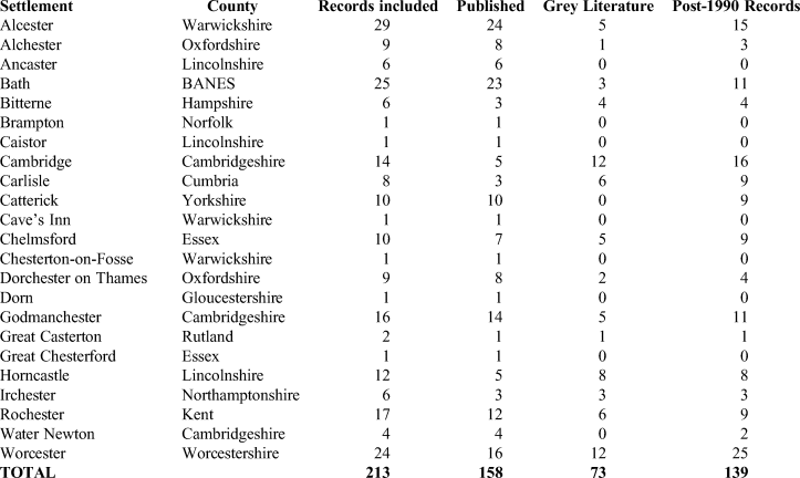
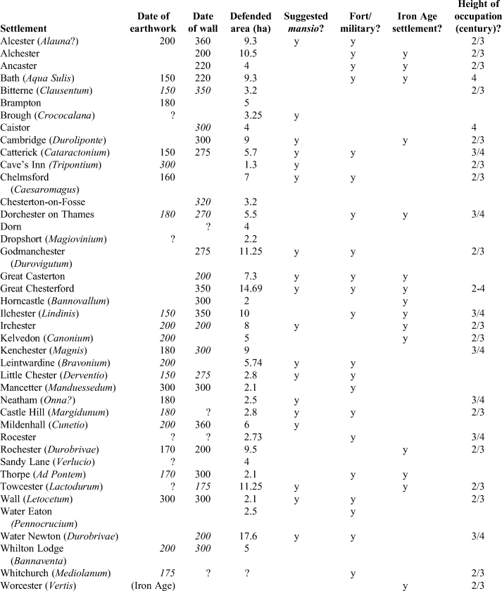
Completed in 2018, the Roman Rural Settlement Project has collected data on over 2,500 settlements dating from the late Iron Age through to the end of Roman Britain in the fifth century. These include almost 300 nucleated settlements, defined as those believed to cover more than 3 ha, although, on practical grounds determined by the sheer scale of the data, ‘small towns’ characterised by earthwork or masonry defences were initially omitted from the project.Footnote 3 Due to a subsequent generous donation by Paul Chadwick, the project team was later able to collect data from a selected sample of such settlements, derived from both published and grey literature reports (table 1), and these were used in the analyses of economy, rituals and lifestyles in Volumes 2 and 3 of New Visions of the Countryside of Roman Britain.Footnote 4 This article is intended to take these analyses a step further, to assess how our understanding of defended ‘small towns’ has changed since Burnham and Wacher's survey and the complementary studies which have followed: on architecture and identity, and on the late and post-Roman periods.Footnote 5 Primarily using a small number of case studies from central Britain (Roman Rural Settlement Project's Central Belt), our survey considers aspects of their material culture and other attributes in order to determine how such sites fit into the broader settlement pattern. We also discuss their role and development within the wider political and economic context of Roman Britain. Finally, ideas for new research agenda are presented that may take us forward in our understanding of such sites.
NUMBER OF RECORDS OF ARCHAEOLOGICAL INVESTIGATIONS INCLUDED FOR SELECTED DEFENDED VICI

TOWNS, SMALL TOWNS, VILLAGES, VICI AND ROADSIDE SETTLEMENTS: ISSUES OF TERMINOLOGY AND CLASSIFICATION
The issue of whether or not a site can be classified as urban is one that has recurred in much of the literature on Romano-British settlement, particularly in discussion of minor nucleated sites, where the term small town is often placed in parentheses or associated with the epithet ‘so-called’, primarily because there is little consensus over which sites should be included in this category.Footnote 6 Further problems occur when trying to classify different types of ‘small town’, with, for example, Burnham and Wacher dividing their 54 sites into six categories: potential cities, minor towns, specialised sites (religious and industrial), minor defended settlements and undefended settlements.Footnote 7 In their classification the urban descriptor is only associated with the first two categories, some 18 towns altogether, with size of the enclosed area being the principal criterion separating the potential cities and minor towns (>4 ha/10 acres) from minor defended settlements.Footnote 8 These three categories account for the majority (29) of the defended settlements, with Bath the only defended religious site and Brampton, Droitwich, Little Chester and Worcester the only defended industrial sites.
There is little doubt that, despite their variety in form and scale, the principal towns (coloniae, municipium, civitas capitals) of Roman Britain with their public buildings and town-houses were ‘urban’ in a way that would have made sense to Roman citizens from across the Empire. Most developed fairly rapidly in the later first and second centuries a.d., and by the end of that century they were likely to have had a set of ‘urban’ attributes — baths, a central place (forum basilica), temples and a street-grid, often alongside other facilities like a theatre, amphitheatre and defensive circuit. Through the development of their associated town-houses they also have a strong association with the elite of the Roman province. Such features have been argued as a conscious re-creation of an interpretation of what it was to be Roman, linking peoples of the provinces into wider ideologies of the Empire and thus creating a sense of belonging.Footnote 9 Outside such towns, as is so evident in Burnham and Wacher's study, there was a sliding continuum of what was construed by them as urban. This contrasts with the language of continental scholars who, in using terms such as ‘agglomération’, vicus, ‘station routière’ and ‘Strassensiedlung’ emphasise a sense of difference from the larger, chartered towns.
This notion of an urban continuum in Roman Britain stems in large part from the economic models developed in the 1970s and a Darwinian optimism of economic growth and evolutionary, civic development through the Roman period in Britain into the fourth century. In his model of urbanism in Roman Britain, published in the same year as The ‘Small Towns’ of Roman Britain and echoing its conclusions, Martin Millett argued that a high water point was reached where the ‘small towns’ were seen as prosperous economic centres, reaching the peak of their wealth in the later Empire and contrasting with the civitas capitals ‘which are not dominated by the same evidence of vibrant economic activity’.Footnote 10 In support of this optimistic view was the work on pottery distributions by Hodder, who, having demonstrated the non-random spacing of Romano-British walled towns, proceeded to argue that the best explanation for the spacing of his second-level centres (‘small towns’) was their function as marketing and service providers which could be traced back to the late Iron Age.Footnote 11 Empirical evidence in support of ‘small towns’ acting as market centres was found in his study of the distribution of late Iron Age and early Roman Savernake Ware, which, on the basis of the concentration of finds of this type of pottery within about 15 km of the kilns, themselves some 3 km from Mildenhall (Cunetio), he argued was marketed through this ‘small town’, the distribution defining its probable market or service area.Footnote 12 Yet, as Timby pointed out in her reappraisal of Savernake Ware, this type of pottery was reaching distant settlements like the late Iron Age oppidum at Bagendon, more than 60 km north of the kilns, before the Roman conquest and before the establishment of the Roman road network and what, initially, would have been no more than a roadside settlement, whose existence was probably due to the establishment of a mansio.Footnote 13 Indeed, by the probable late first-/early second-century date for the foundation of the mansio, the Savernake industry was in decline. The relationship between the Mancetter-Hartshill pottery industry and the development of the ‘small town’ at Mancetter is also more apparent than real. In so far as the distribution of stamped mortaria can be taken as representative of the market area of the industry as a whole, it is clear that, as well as local consumers in the Midlands like Wroxeter, this coincides with military establishments occupying the northern half of Britain and extending as far as the Antonine Wall; the scarcity of stamped mortaria finds to the south of the kilns being a notable feature of their distribution.Footnote 14 Given the difficulty of demonstrating the market function of larger towns, such as Silchester and Wroxeter, it should not perhaps come as a surprise that it is just as difficult to define market or service areas of ‘small towns’.Footnote 15 This finds support in broad perspective from the countryside, including nucleated settlements, which, excepting the development of villas, provides no evidence for growth in Roman Britain beyond the turn of the second and third centuries.Footnote 16
In challenging the assumption that ‘small towns’ fulfilled a market role, intermediate between the larger towns, we should also remind ourselves about the weakness of the case for other urban attributes associated with the ‘small towns’. For example, not one has convincing evidence of a street-grid, as opposed to lanes running off the main through-road(s), and public buildings are limited to structures which are generally considered to be mansiones or, less certainly, mutationes and their associated bath-houses. The service role of those settlements, with their evidence of probable mansiones or mutationes in support of the cursus publicus and the movement of goods, units of the Roman army and the negotiatores who supplied the army along the major roads of the province, was, however, paramount. The province-wide distribution of terra sigillata or Dressel 20 olive-oil carrying amphoras and the northern British distribution of the Mancetter-Hartshill mortaria are good examples of the movement by road of goods which survive in the archaeological record. One way, then, of thinking of the service area of a roadside settlement with a mansio, would be the road corridor between it and its nearest equivalent neighbours.
Against this background the Roman Rural Settlement Project took a fairly broad approach to settlement classification from the outset, in order to encompass the enormous variety of sites within the province.Footnote 17 Nucleated settlements were simply divided into those that lay on the major transport routes — termed roadside settlements — and those that did not, which were termed villages, though with the understanding that such sites were far removed from the medieval and modern concepts of the village.Footnote 18 In addition, a selected sample of nucleated settlements attached to military forts was included, termed military vici to distinguish them from the general term vici (sing. vicus), which can be translated as, simply, village, or as referring to a neighbourhood or street of a larger town.Footnote 19 Interestingly the only epigraphic evidence which sheds any light on what these ‘small towns’ were called in Roman times is provided by two mortaria which carry the stamp Cunoarus vico Duro(brivae). Footnote 20 However, the term ‘vico’ could refer either to the whole settlement, which also happens to be the largest of the ‘small towns’ in Roman Britain, or just the potters’ quarter. Some roadside settlements in central England in particular developed on the sites of military vici, or of the forts themselves after their abandonment, and there is a strong correlation with those that were later associated with defensive circuits (see discussion below). It is these defended roadside settlements that this paper is primarily concerned with, and it is the provision of such defences that is one of the primary reasons they have typically been referred to as ‘defended small towns’. The lack of, or at least ambiguity of, any urban characteristics has led to the preferred use of the term ‘defended vici’ within this article. An alternative, but more cumbersome solution, might be to use the term ‘defended roadside settlement’, but this would equate sites like Caistor and Horncastle (Lincs.) and Irchester (Northants.), which were not located on major roads, with the great majority which were thus located.
RECENT INVESTIGATIONS AT DEFENDED VICI
At the time of Burnham and Wacher's Reference Burnham and Wacher1990 survey, and even Brown's Reference Brown1995 edited volume on the small towns of eastern England, many of the settlements classed as ‘small towns’ had received relatively little archaeological attention, or at least little that had been fully published. Yet quite a number of these sites lay within historic towns, and the redevelopment of many of these towns over the past 30 years has led to a surge in developer-funded excavations, evaluations and watching-briefs, which continues apace to this day.Footnote 21 Unfortunately, many interventions have been on a very small scale, and by themselves are insufficient to address wider research issues, although the cumulative value of such fieldwork can be somewhat greater. However, larger investigations have certainly taken place, providing evidence from material culture and environmental remains that is starting to transform our understanding of such settlements. Recent excavations in advance of regeneration within and outside the walled area of Roman Towcester, Northants. (Lactodurum), for example, were over 3 ha in extent. These investigations revealed relatively intense early to mid-Roman activity, though with suggestions of a later decline coming after the building of the defences, and with evidence of agricultural activity within the walls at this time.Footnote 22
On a much larger scale, excavations in advance of the A1 road scheme at Catterick, N Yorks., have revealed significant parts of the nucleated settlement, which was founded in association with the Flavian fort during the a.d. 80s.Footnote 23 The vicus expanded rapidly along Dere Street, developing into a more formal settlement during the early second century, including a supply depot, and was enclosed by a ditch and rampart. The fort and defences fell out of use during the third century, though the settlement continued to develop, and was partially enclosed by masonry defences, probably in the later third century, at the same time as a new fort was constructed. After a possible period of decline in the earlier fourth century, activity seems to have been renewed, and included the construction of a number of substantial stone buildings. Occupation certainly continued to the end of the fourth, and probably into the early fifth century, its longevity and apparent late prosperity undoubtedly due to its key location on military supply routes (see discussion below).
It is not just developer-led excavations where advances are being made. At Dorchester-on-Thames in Oxfordshire, for example, research excavations from 2008 to 2018 within the heart of the walled Roman settlement, now an allotment, have revealed evidence, including cob and beamslot buildings, for earlier Roman occupation that had previously been scarce.Footnote 24 The overall scale of new archaeological work at defended Roman vici is such that, of the approximately 40 settlements that have been classified as such, just 23 had some data collected as part of the Roman Rural Settlement Project, and even then this was far from a complete inventory of all investigations, some settlements just relying on one or two published accounts (see table 1).Footnote 25 Nevertheless, it still represents a useful resource with which to start to re-assess their development, function and relationships with other settlements; all data are available on the ADS website.Footnote 26
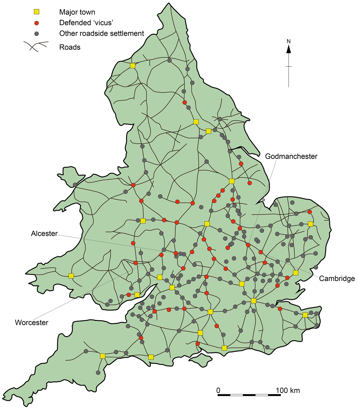
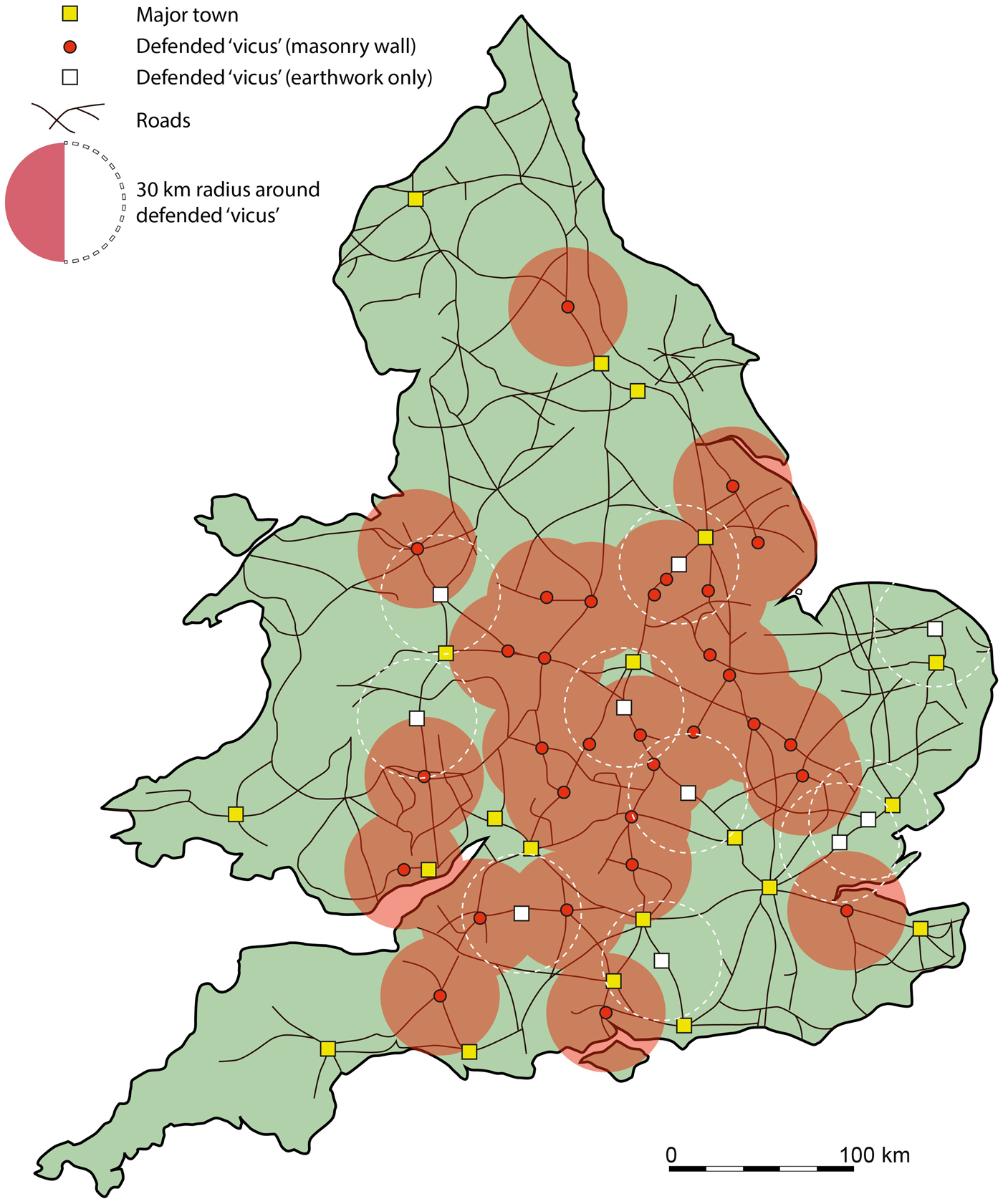
In deciding on our choice of case studies we have been guided by the number of reports, including ‘grey literature’, produced for any of these settlements since 1990 and the amount of information, such as detailed finds reports, they contain. On this basis four settlements, with the highest number of reports (11–25), have been selected as case studies to enable a more detailed assessment of how new investigations have increased our understanding of such sites, though also highlighting areas where information is still deficient. Although Bath also had 11 reports, we have not included it here as it has been the subject of a recent synthesis.Footnote 27 All of the chosen settlements lie within the Project's Central Belt region, which also has the highest density of defended vici (fig. 1).Footnote 28 In the case of Worcester, although there is now less certainty of Roman-period defences in the light of recent work, there is a compelling case for synthesis given the number of post-1990 reports (25).
Distribution of nucleated settlement in Roman Britain (excluding military vici), with case studies indicated.

GODMANCHESTER
Godmanchester in Cambridgeshire lay on a gravel spur along the line of Ermine Street just south of where the road crossed the river Ouse, with other roads leading south-east towards Cambridge and south-south-west towards Sandy. The town has seen significant archaeological investigation since the mid-twentieth century, in particular the work of Michael Green, who undertook excavations spread across c. 10 ha, mostly in the central, intramural part of the Roman settlement. This work has only very recently been published, though earlier interim results allowed Burnham and Wacher to present a detailed summary of the development of the town, including its mansio, bath-house, other possible public buildings, road layout, defences, religious infrastructure and economy.Footnote 29 Archaeological investigations since 1990 have been mostly outside the late Roman walls, in the suburbs of the settlement, providing valuable further insights into the economy, burial rituals and later development of the town.Footnote 30 Much of this work has comprised very small scale excavations and watching-briefs, though larger investigations took place to the north (The Parks) and south (London Road) of the town.Footnote 31 In the wider hinterland, this part of Cambridgeshire has witnessed extremely high levels of development over recent years, continuing with the current major road scheme work on the A14.Footnote 32 This has resulted in more detailed archaeological knowledge of surrounding settlement patterns and farming regimes, which should ultimately facilitate an improved understanding of the social and economic relationships between ‘town’ and country.Footnote 33 Of particular significance has been the discovery and excavation of numerous Romano-British farmsteads of varying scales, especially on the southern periphery, such as that at Bearscroft Farm excavated c. 600 m south-east of the later walled settlement, which indicate a far more complex agricultural organisation than the simple town/villa model suggested by Green.Footnote 34
Godmanchester was one of a number of nucleated Roman settlements in eastern and central Britain that developed on the site of a possible fort (see discussion below), though scatters of Iron Age finds suggest that there may have been some pre-conquest activity.Footnote 35 The nearby Roman farmstead at Bearscroft Farm just noted certainly developed from the Iron Age, while many of the Roman farmsteads excavated as part of the recent A14 road scheme also had Iron Age antecedents.Footnote 36 The possible Claudian and Neronian forts nevertheless represent the first substantial occupation at Godmanchester itself, with traces of an associated vicus settlement, including timber buildings, being found during early excavations just to the north. No further trace of the military vicus has been conclusively demonstrated from more recent investigations. The ‘forts’ were abandoned c. a.d. 70 and during the later first century the settlement developed as an essentially agricultural community alongside the newly built Ermine Street; rectangular and circular timber buildings and ditches of roadside plots and droveways have been revealed within many excavations, though the systems of land management are not thought to have been as extensive as previously believed.Footnote 37 At this point, there is little to distinguish Godmanchester from any number of nascent roadside settlements emerging across southern and central parts of the province; this was to change during the early second century, when a range of substantial masonry buildings was established in the north-west of the settlement. The complex of mansio, bath-house, temple and large aisled building is well-known in outline; the few more recent small-scale excavations in this area have revealed little new information except that there were further structures built on the same alignment as the mansio, and that there was at least one high-status child cremation burial, dating to the mid-second century a.d.Footnote 38
The ‘official’ masonry buildings at Godmanchester clearly represent a major investment, which is almost certainly related to larger-scale developments in the region and province as a whole, and to its position on the road network. This was a period when agricultural strategies in the West Anglian Plain (incorporating the Nene and Ouse Valleys) were rapidly changing, with an expansion of areas under arable cultivation and an almost total dominance of spelt wheat production, alongside an increase in numbers of cattle, which were primarily used as traction for ploughing.Footnote 39 Complex farmsteads developed on the gravel terraces and claylands, linked by trackways and surrounded by networks of fields and pasture, all geared towards producing an increasing agricultural surplus. This was also a period when great changes were occurring in much of the Fens, with major drainage projects and an expansion of settlement and no doubt cultivation.
Godmanchester lay in a key location with regard to collection (probably as part of taxation) and transportation of agricultural surplus to the military in the North, being on the principal north–south road of the province and near to the Fen edge sites such as Camp Ground, which is interpreted as an inland port, with official connections.Footnote 40 Features such as corn-driers, quernstones and threshing floors indicated that cereal processing was being carried out in Godmanchester, and, despite evidence for other craftworking and commercial activities, agriculture clearly remained its key economic base.Footnote 41 Whether or not it had the same level of arable processing capacity as in some nearby ‘specialist’ farms such as Langdale Hale is uncertain,Footnote 42 but it is likely to have played a key role in the distribution network of cereal grain, perhaps alongside other specialist ‘depots’ in the vicinity, one possible example of which was recently excavated along the A14 road scheme.Footnote 43 Tower granaries have been identified attached to the mansio at Godmanchester, while the substantial masonry aisled building may also have been used for grain storage. It is feasible that even the large gravel-floored basilican building constructed during the early third century just to the east of the mansio complex could at least partially have acted as an ‘official’ grain store, although, despite bearing no resemblance to the forum basilica of the larger towns, it has been interpreted as a town hall, argued as marking the community's achievement of self-government.Footnote 44
Godmanchester's key location on crucial supply networks was probably the reason for the erection of its walled defences, thought to date to the later third century a.d., based upon a stratified coin and a radiocarbon date.Footnote 45 Prior to this point, the likelihood is that the town remained unenclosed, though a second-century ditch on a different alignment has been argued to be part of a smaller (c. 8.06 ha) defensive circuit.Footnote 46 The fire which destroyed most of the mansio, bath-house and temple in the late third century, seems to have halted the completion of the walled circuit, though this was recommenced in the fourth century, resulting in the closing off of the north-west corner. Here, the ruined mansio was eventually replaced with two timber structures, and the aisled building was now used for metal-working, as many other public buildings in late Roman towns.Footnote 47 This zone, which also included one of the original tower granaries attached to the mansio, the partially re-built bath-house and a replacement temple of non-Romano-Celtic form, thus became the most protected space in the settlement, and may have acted as a temporary safe area for the increasingly valuable agricultural products needed by the state in Britain and on the Continent, as discussed below.
Unfortunately, the late Roman sequence within this central part of the town is still not well understood, but the evidence suggests a degree of dereliction and a decline in traffic along the main road. More recent excavations in the suburbs have revealed a zone of pottery production to the north at the Parks, which appears to have ceased during the early fourth century, at around the same time as an inhumation cemetery was established; the 62 graves are thought to represent the periphery of a larger, perhaps more ‘managed’ funerary zone, though with no direct evidence.Footnote 48 Further to the south, along London Road, various excavations have revealed second- to third-century enclosures and domestic occupation, with slight indications of specialist horse ranching, perhaps to support official travellers along the road system.Footnote 49 Large areas of this suburb appear to have been abandoned during the later third century, and parts of a late Roman inhumation cemetery were revealed in the vicinity.Footnote 50 There was some renewed non-funerary activity in the mid-fourth century, including various agricultural features such as corn-driers, which may possibly have been linked with renewed activity in the area of the mansio.Footnote 51
Overall, the evidence from both the settlement core and the suburbs suggests a contraction of the area occupied during the fourth century, though with continued activity, perhaps focusing on its role within the distribution network of agricultural produce, including cereal processing and temporary storage. Agricultural settlements in the hinterland of the town show evidence for a re-alignment during the later Roman period, with a number of farmsteads going out of use, and others developing modest villa architecture,Footnote 52 perhaps representing a consolidation into smaller numbers of agricultural estates in an attempt to boost agricultural productivity, or at least maintain productivity in the face of a declining population and worsening climatic conditions (see discussion below). If this was the case, then it does not appear to have been to the benefit of Godmanchester, where any ‘civic’ attributes that may have existed must have largely disappeared.
CAMBRIDGE
Cambridge lies c. 23 km to the south-east of Godmanchester, linked by a road that runs through areas of clays and gravels on the southern edge of the Fenland landscape; another road (Akeman Street) ran from Wimpole Lodge on Ermine Street to the south-west, through Cambridge and northwards towards the eastern edge of the Fens. The site of the Roman defended vicus is dominated by a gravel-capped hill and ridge, which provides a strategic crossing of the river Cam. A series of excavations took place in the latter half of the twentieth century, largely within the limits of the late Roman walls, though most of these had not been fully published at the time of Burnham and Wacher's Reference Burnham and Wacher1990 survey. Interim results, nevertheless, enabled some characterisation of the internal walled area of the settlement and its morphology, which they categorised as a ‘Minor Defended Settlement’, highlighting the apparent paucity of ‘urban’ facilities.Footnote 53 There have been numerous archaeological investigations of Roman Cambridge since 1990, mostly by the Cambridge Archaeological Unit, and the results of earlier work have now been published, albeit with many issues still remaining.Footnote 54 Discussion of how far Cambridge can be classified as a Roman town has recurred through much of the resultant literature on the settlement.Footnote 55 In part this is because of the small-scale nature of the investigations, these rarely being more than keyhole excavations, which are unlikely to reveal much of the settlement's wider character. Exceptions include an area of 60 m2 excavated at Castle Street in the heart of the walled area,Footnote 56 and numerous extramural sites, which are now providing better insights into the nature and development of the settlement.
Unlike Godmanchester, there is evidence for significant late Iron Age activity at Cambridge. Ditched and palisaded enclosures of late Iron Age date were found in earlier excavations at Castle Hill in the centre of the later walled Roman settlement,Footnote 57 while other features of a similar date were revealed on the periphery at sites like New Hall and St Edmund's College.Footnote 58 The apparent scale of occupation, together with the volume and types of associated artefacts, which included many brooches and imported Roman pottery, suggest a regionally significant late Iron Age settlement, which developed through into the early Roman period. There appears to have been minimal disruption to the physical character of Iron Age occupation, at least up until c. a.d. 60, when many of the earlier pits and enclosures were filled in.Footnote 59 It is around this time that there are tentative suggestions of a Roman fort, based upon the presence of a substantial V-shaped ditch, thought to have been constructed in the aftermath of the Boudiccan revolt (contemporary with the second fort at Godmanchester),Footnote 60 though the evidence is very equivocal, and only a single item of early military equipment has been recovered in all investigations.Footnote 61 Jeremy Evans et al. have also recently dismissed an early military presence, based on evidence from coins and samian ware.Footnote 62 Nevertheless, even if military occupation cannot be conclusively demonstrated, this period was one of noted change, both within Cambridge and in the wider hinterlands, with some farming settlements, such as Addenbrookes 4 km to the south, being abandoned or replaced by field-systems, and others, such as North-West Cambridge Site IV, starting to expand rapidly.Footnote 63
There seems little doubt that the later first and particularly the second century a.d. was the period of major development at Cambridge. As with Godmanchester, this was part of significant wider landscape changes, demonstrated by the major expansion of rural settlement in the hinterlands, including the complex farmstead at Vicar's Farm, c. 1 km to the west, which seems to have been a specialist processing facility for locally grown spelt wheat.Footnote 64 The status of Cambridge itself at this time remains uncertain, though apart from what appears to be a relatively modest-sized building with a heated room, suggested to be part of a mansio,Footnote 65 there are no masonry buildings certainly of this date (but see discussion of Kettle's Yard below), and the settlement may have been largely agricultural in nature, as suggested by systems of fields, trackways and paddocks revealed around its fringes.Footnote 66 There was also some evidence for industry on the periphery, including localised iron smithing and possible pottery production and horn-working at Jesus Lane to the south of the river Cam, but nothing on any significant scale.Footnote 67 Religious activity is attested through the cellared-shrine building dating from the later second to early third century near the main road junction in the centre of the settlement, and the subsequent group of ritual pits and small pentagonal shrine in the vicinity.Footnote 68 Although undoubtedly of local importance, the nature and scale of these features does not suggest any wider religious significance, with temples of much greater size and longevity being found in other rural and nucleated settlement contexts.Footnote 69
The later Roman period appears one of mixed fortunes for Cambridge and its hinterlands. Burnham and Wacher describe a third-century decline for the settlement, with a number of abandoned buildings, though this was believed to have been followed by a slight revival in the fourth century, indicated by re-metalled lanes and new timber buildings.Footnote 70 This may have been stimulated by the building of an irregular walled circuit, which enclosed c. 9 ha of the settlement,Footnote 71 centred on the higher ground by the road junction, and cut through a number of existing buildings, including the supposed mansio. The rammed footings of a masonry structure excavated in 1994 at Kettle's Yard just inside the line of the wall may have been part of the defences, or else were built as part of the ‘revived’ occupation, though their dating remains very poor.Footnote 72 More recent small-scale excavations in 2011 and 2015 in this same area revealed evidence for extensive terracing, probably undertaken at the same time as the construction of the defences, along with two wells which contained material suggestive of a high-status building, possibly of the earlier Roman period.Footnote 73
Just how extensive a ‘revival’ there was in the late Roman period is uncertain, but hints that it may have been quite patchy come from the recent excavations at Castle Street, where very little late Roman pottery was recovered from the disturbed upper levels, and from a watching-brief carried out in 2000 on the southern side of Castle Hill, where late Roman material was absent.Footnote 74 Within extramural areas, relatively little late Roman domestic activity was found in any of the archaeological investigations, with recent excavations at the School of Pythagoras revealing a dark earth layer of third-century date covering earlier intensive activity belonging to the second century.Footnote 75 Overall, it appears that while there may have been some re-invigoration of occupation within the newly walled area during the fourth century, most of the settlement remained without evidence of new development.
In many extramural areas, earlier activity was succeeded by evidence for late Roman burial. Cemeteries were poorly known at the time of Burnham and Wacher's survey, but an increasing number have been revealed since, all in relatively small groups, although some potentially form part of much larger burial grounds. The 32 inhumation burials from Jesus Lane, c. 550 m south-east of the walls, for example, have been suggested as being connected with further burials found in Park Street, 170 m to the north-west, indicating a possible late Roman burial ground of up to 1,000 individuals.Footnote 76 Even if this is eventually proved correct, it only amounts to about ten burials a year over a 100 year period, a rate that is quite compatible with the overall impression of a contracting population. Based upon recent excavations in north-west Cambridge and elsewhere, it is far more likely that there was a series of smaller cemeteries around the periphery of the settlement, similar to the situation seen at other nucleated roadside settlements of limited size in the province.Footnote 77 Interestingly, a palaeopathological study of the skeletons from Jesus Lane indicated that the people had led tough working lives, and in this respect is similar to other results from later Roman rural contexts within central England in a recent study by Rohnbogner, which were somewhat different from the urban signature of skeletons from Roman Winchester used as comparison.Footnote 78
The variable late Roman sequences observed in excavations in Cambridge correspond with mixed development in the wider hinterland. Over half of all excavated rural settlements in the vicinity were found to be reducing in size and complexity, or had been abandoned, by the end of the third century, while others were at their height during this time, notably the specialist agricultural-processing farmstead at Vicar's Farm, and also, perhaps, the recently excavated complex farmstead at NIAB Huntingdon Road, 1.4 km to the north; the latter had mid- to late Roman cemeteries of over 50 inhumation burials, although the majority of Roman pottery from the site was second- to third-century in date.Footnote 79 Complex farmsteads such as these, along with a number of poorly-understood mid- to late Roman villas in the vicinity of Cambridge, may have consolidated land and resources into larger estates in order to maintain or increase agricultural capacity, as was suggested above for the landscape around Godmanchester.
So, with all the recent archaeological work in and around the modern city, where does this leave our understanding of Roman Cambridge? Although the settlement may have been of considerable size,Footnote 80 occupation was probably not intensive, and like most other nucleated roadside settlements, it is likely to have been a community with a strong agricultural economic base, from the late Iron Age to the late Roman period. Unlike Godmanchester, it does not seem to have developed any significant craftworking capacity. In a recent study of the nearby pottery industry at Horningsea, Evans et al. concluded that Cambridge's pottery assemblage (or at least a partial sample of it) is not typical of urban sites, instead being more akin to ‘something between a village and a small town’.Footnote 81 Aside from the putative mansio, and possibly a high-status building in the vicinity of Kettle's Yard and the relatively short-lived shrine, no official or public buildings have been located, and it is only the fourth-century walls, and perhaps the appearance of cellared buildings and a slightly more complex system of metalled side lanes (whose arrangements are still largely uncertain), that differentiate it from most of the other nucleated roadside settlements that are so prolific across central and eastern parts of the Roman province. As previously noted by Taylor, it was probably in the context of the agricultural supply network that Cambridge was fortified at this time, rather than for any intrinsic civic or economic importance.Footnote 82 Indeed, Evans and Ten Harkel have suggested that it was largely topographic considerations that led to this settlement in particular being fortified in this way, as the core settlement lay on a more easily defensible hill rather than the more typical flat and low-lying contexts of other places in the vicinity.Footnote 83
WORCESTER
Roman Worcester lay on the eastern bank of the river Severn, at the site of a probable ford across the river. It has been identified as Vertis in the Ravenna Cosmography, lying on the road from Gloucester to Droitwich, with other possible roads leading towards Kenchester and Alcester, though there is little direct evidence for these. In Burnham and Wacher's survey, it was stated that ‘Less is known about the small town of Worcester than probably almost any other in Britain’.Footnote 84 At the time they were largely reliant upon Barker's Origins of Worcester, with very little being known beyond the major earthwork fortifications, which were thought to date to the mid- to late Roman period, the existence of a substantial ‘suburb’ to the north, and the fact that iron smelting was carried out on a considerable scale, so much so that it was classified as an ‘industrial settlement’.Footnote 85 Since then, there has been a great deal of archaeological work undertaken in the city, almost all of it within the area of the northern Roman ‘suburb’, which has done much to increase our understanding of its character and development (discussed below). Very little investigation has taken place within the defended area, and indeed the exact course and nature of the defences remains uncertain. However, a recent programme of work at the King's School, on the site of the Castle, has, crucially, confirmed earlier suggestions that the huge defensive rampart and ditch (the latter up to c. 30 m wide and 7.6 m deep) revealed previously in small sections further to the north (notably at Lich Street) did in fact date originally to the early Iron Age, and not to the mid- to late Roman period.Footnote 86 At least some parts of the Iron Age ditch and rampart appear to have been re-utilised within the Roman settlement; however, Napthan has argued that much of the ditch may have been almost entirely silted up by this time, and further suggested that there was little evidence for the settlement being formally defended or enclosed on its southern edge, though this remains disputed.Footnote 87 Whether or not the earlier defensive ditch and rampart were fully utilised, the evidence currently available suggests that Worcester was not among those nucleated settlements that appear to have received ‘new’ defences during the mid- to late Roman period. In this respect, it may be more similar to the many other undefended roadside settlements of the region, and indeed, it bears many similarities with Ariconium, a major iron-producing settlement in the Wye Valley, 37 km to the south-west.Footnote 88
As with Ariconium, the Roman settlement at Worcester clearly developed from Iron Age origins, although the scale and nature of late Iron Age activity remain uncertain. Scattered evidence for occupation of this date was found in investigations to the north of the defensive enclosure, including pits, a possible roundhouse and a horse burial at Deansway.Footnote 89 Reasonable numbers of Iron Age Dobunnic coins recovered from the city also attest to occupation of this date, possibly indicating a site of some status.Footnote 90 Evidence for early military activity at Worcester is equally ambiguous, though the Roman military objects recovered from the Sidbury and Deansway excavations certainly suggest some presence.Footnote 91 A short-lived early Roman settlement lying just over 1 km to the west of the river Severn at St John's was suggested as a trading post established by locals to exchange goods with the army.Footnote 92 Much clearer is the evidence for significant expansion of the settlement during the later first and particularly the second century a.d.; this accords well with other rural settlements in the Severn and Avon Vales, which increase sharply in number during the second century.Footnote 93 Activity in Worcester at this time is characterised by reasonably dispersed areas of occupation alongside agricultural activity and industrial zones. One of the largest areas of recent excavation, at the University of Worcester City Campus, saw activity primarily of second- to third-century date spread over 2 ha along the edge of the gravel terrace and onto part of the reclaimed floodplain.Footnote 94 Features included timber buildings, gravel quarries and dumps of refuse, alongside evidence for bone-, copper-alloy- and shale-working.Footnote 95 Just to the south of these excavations, a number of fairly recent archaeological investigations at the Hive, the Butts and Farrier Street have revealed more intense levels of activity, particularly at the Hive, where a series of timber strip-buildings appear to have been part of a small-scale commercial district along a road leading to the riverside, and where there is also evidence for extensive floodplain reclamation.Footnote 96 The majority of buildings encountered in all excavations of Roman Worcester were relatively simple timber structures, though a stone-footed building was revealed at Deansway, and there is evidence for higher-status buildings with tessellated floors at Britannia Square to the north, and a masonry building with mortared floors and painted walls further south at the City Arcade.Footnote 97 Further evidence for more substantial buildings comes from scatters of high-status building materials (masonry blocks, tesserae, painted wall-plaster, etc.) at various places in the city, with a notable concentration within a late Roman stone-lined well at the Butts.Footnote 98
While there is clearly a substantial agricultural element to the economy of Roman Worcester, its industrial capacity would appear to have been its mainstay, at least during the second and third centuries. An ‘iron-smelting factory’ was revealed during early excavations at Broad Street, while further shaft furnaces or tapping pits have been found further south at City Arcade.Footnote 99 The extent of iron production in the settlement is indicated by the presence of large quantities of smelting slag found in many excavations across the city and being used for road surfacing and floodplain reclamation. Iron production seems to have been carried out at various places across a wide area, with deposits of smelting slag and furnace lining found during excavations at the former Worcester City football club, almost 2 km north of the large Iron Age ditch.Footnote 100 Until fairly recently much of the evidence for iron-working at the settlement was concerned with smelting, but indications of large-scale smithing are now also coming to light, most notably from a large and well-preserved smithy complex revealed at the Magistrates Court, dating from the later third to early fourth century.Footnote 101 Together this evidence indicates a significant manufacturing centre, especially when seen alongside that for bone-working, shale-working, copper-alloy-working, glass-working and possibly pottery production. For the present, our inability to provenance iron artefacts prevents us from assessing the geographic extent of the distribution of products from Worcester.
The main floruit of activity at Worcester appears to have been in the second and third centuries a.d., with evidence for widespread and sustained contraction after this point, mirroring the pronounced fourth-century drop in rural settlements in the Severn and Avon Vales.Footnote 102 Iron production seems to have lessened considerably, as at other significant iron-working centres, both in the vicinity, such as Ariconium in Herefordshire and Dymock in Gloucestershire, and across much wider parts of the Roman province, perhaps responding to increased production in parts of the Forest of Dean and the Severn Estuary, which may have deprived Worcester of at least some of its ore which has been sourced to the Forest of Dean.Footnote 103 Occupation certainly continued, however, and there are some indications of an economic re-alignment towards a more overtly agricultural base. Later Roman stock enclosures were suggested at the City Campus and Deansway sites, while soil micromorphology also indicated that animal penning was taking place at Farrier Street.Footnote 104 At the Hive there was a change of land use with the construction of an aisled building, thought to have been of agricultural function, and an accumulation of tillage soil occurred from the late Roman period onwards. Recent strontium, oxygen and carbon isotope analyses on cattle remains from the Hive indicated that some adult animals dating to the mid- to late Roman period were not bred locally, part of an increasing body of evidence suggesting long-distance droving in Roman Britain.Footnote 105 Roadside settlements like Worcester may have been important nodes on this droving network. The evidence overall from Worcester, which includes finds of late Roman shelly wares from midden deposits at the County Education Offices, points to continued occupation at some level to at least the end of the fourth century, and it could be that most resources by this point were focused upon maintaining agricultural production (see discussion below).Footnote 106
There is no doubt that our knowledge of Roman Worcester has come a long way since Burnham and Wacher's Reference Burnham and Wacher1990 survey, yet there is still plenty of uncertainty with regard to its overall status. Most syntheses and excavation reports for sites in the city still allude to an ‘urban core’ within the defended area, yet it is far from clear if any such core existed, especially as the defensive ditch now seems to be more a partially silted (though certainly re-utilised in places) relict of much earlier times, rather than a late Roman initiative to defend the principal part of the settlement. Instead, what have been purported to be the northern ‘suburbs’ probably represent the greater part of the main settlement, which seems likely to have developed in a piecemeal fashion over a very wide area, with systems of more organised metalled side lanes and dispersed pockets of settlement, industry and agriculture situated throughout. Its economic importance beyond that of a ‘typical’ agriculturally-based roadside settlement lies in its impressive industrial capacity during the second and third centuries a.d., in which respect it is one of a number of such nucleated settlements lying to the north of the major Forest of Dean ore fields.
ALCESTER
The Roman nucleated settlement at Alcester in Warwickshire is located c. 25 km east of Worcester, at the confluence of the rivers Alne and Arrow, the latter a tributary of the river Avon. It has been identified, though not universally accepted, as Alauna in the Ravenna Cosmography, and lies by the intersection of two main Roman roads, Ryknield Street, which runs north–south from Derbyshire to Bourton on the Fosse Way in Gloucestershire, and the ‘Salt Way’, which runs west–east from Droitwich in Worcestershire to past Lower Lea in Oxfordshire.Footnote 107 In terms of its context within the Roman Rural Settlement Project, it lies almost directly on the boundary between the Central Belt and Central West regions, which is reflected in the varied settlement patterns to the north and south.Footnote 108
The Roman vicus has seen much archaeological investigation since the 1950s, mostly outside the late Roman defended area, though at the time of Burnham and Wacher's survey there was only limited publication of the results.Footnote 109 This has now been largely rectified for the pre-1990 work with the Alcester monograph series. There have been many excavations, evaluations and watching-briefs since then as a result of increasing development, much of which work has been summarised (for the period 1990–2004) by Hodgson.Footnote 110 Most of the post-1990 work has been of very small scale and remains as unpublished ‘grey literature’, though more extensive excavations were undertaken at the Hockley Chemical works in the north-eastern part of the southern extramural area of the Roman settlement and at Bleachfield Street a little further to the west.Footnote 111 In addition, recent excavations over 1.5 ha in extent were undertaken immediately to the west of the main Roman settlement at Allimore Lane, north of the Salt Way road.Footnote 112 Most of the more recent archaeological work in the town has not fundamentally altered Burnham and Wacher's characterisation of the Roman settlement, though it has provided a clearer picture of its morphology, extent, development and economy.Footnote 113
There is no definite evidence for late Iron Age occupation within the core of Roman Alcester, though finds of Iron Age coins and brooches hint at pre-conquest activity.Footnote 114 Furthermore, recent excavations on the periphery are starting to reveal more extensive Iron Age landscapes, with pottery of late Iron Age to early Roman date being recovered from a sub-rectangular ditched enclosure to the north, and possible continuous settlement activity from the early Iron Age to Roman period being revealed at Allimore Lane to the west.Footnote 115 Into this seemingly dispersed Iron Age occupation was introduced an early Roman military presence, with a fort, possibly of Claudian date, being identified from cropmarks on higher ground to the south.Footnote 116 The existence of an early fort within the area of later Roman settlement is thought most likely, suggested as being located around Bleachfield Street on the basis of military finds from nearby excavations.Footnote 117 Excavations in 2005 at Bleachfield Street revealed timber beam-slot buildings and ditches thought to have been part of the possible fort dating to the later first/early second century a.d., though definitive evidence is still lacking.Footnote 118
The main settlement appears to have developed in the later first and second centuries around the east–west route of the Salt Way to the east of Ryknield Street, with an irregular and evolving system of lanes developing principally to the north of this road. The precise extent and development of the road/lane system remains unclear, however, and there is even uncertainty over whether the line of Ryknield Street does indeed mark the western boundary of the settlement or whether it was diverted to run directly into the main settlement, perhaps aligned upon the early fort, as has been suggested.Footnote 119 There is also some ambiguity concerning the overall extent of the settlement, though recent investigations on the periphery have provided further clarification. In particular, excavations as part of a flood alleviation scheme in 2002, revealed more intensive occupation than expected over 500 m south of the later walled area, including minor industrial activity and large quantities of finds, though much of this may have derived from middens on the edge of the settled area.Footnote 120 As already stated, the supposed north–south line of Ryknield Street to the west is thought to mark the western edge of the settlement, with a poorly understood cemetery lying immediately to its west. However, excavations to the north-west, near where the Salt Way road crosses Ryknield Street, revealed further low-intensity domestic and agricultural activity, thought to represent part of a ribbon development alongside the Salt Way.Footnote 121 Although suggested as a separate and possibly long-lived agricultural settlement, it seems likely that by the early second century at least it became part of the extended nucleated settlement of Alcester, which appears to have been spread over a considerable area, albeit with varying levels of intensity and without necessarily having a more concentrated, built-up ‘urban core’.
The major period of growth and economic prosperity for Alcester seems to have been the second to earlier third centuries a.d., which corresponds with the peak in numbers of rural settlements in use within the surrounding 25 km radius. It has been estimated that the maximum extent of Alcester (c. 30 ha) was reached by the end of the second century, by which time there were large numbers of timber and masonry buildings of different forms and construction methods found across the settlement.Footnote 122 Most of the buildings were too fragmentary to determine function, but they would seem to comprise the usual array of domestic, workshop and agricultural structures. There is, as yet, no evidence for densely packed ‘commercial’ strip-buildings along road frontages, typical of many larger urban centres, though a few of these buildings have been located.Footnote 123 Compared with many other ‘small towns’, there appears to be reasonable evidence for buildings with architectural elaboration and finery, such as painted plaster walls, marble fragments, tiled roofs, opus signinum and tessellated floors. A possible mansio with heated rooms was identified alongside the Salt Way, though other buildings of note were probably private residences, pointing to the relative economic and social importance of the settlement.Footnote 124
A significant episode in the development of Roman Alcester was the construction of a substantial curvilinear banked enclosure encompassing an area of 8 ha to the north of the main occupied zone. Relatively few excavations have taken place in this enclosed area, and its generally cited construction date of the start of the third century is based on very little direct evidence.Footnote 125 It would seem, however, that the area was largely agricultural prior to its encirclement, possibly being used for horticultural crops, although the excavated sample remains too small to be certain of its nature.Footnote 126 This also ensures that it is difficult to define the character of subsequent intramural development. Several timber and masonry buildings were constructed, some seemingly of relatively high status, though without any evidence for any regular alignments that would indicate a planned street-grid. Too little has been investigated either to confirm the character of the settlement or to help us understand why this area was chosen for enclosure.
The development of this essentially new area of enclosed settlement appears to have had an effect on parts of the remaining settlement. Although there was no large-scale abandonment, there was a lessening of activity in some parts of the settlement closer to the defences, perhaps leading to a separation into two main settlement foci — the intramural area and a zone alongside the Salt Way directly to the south, with at least some of the area in-between either being abandoned or used for burial.Footnote 127 There are also indications of a late Roman contraction of occupation in more outlying parts of the settlement to the south and west.Footnote 128 This corresponds with a general late Roman decline in rural settlement numbers in the environs of Alcester, although this decline may be partly due to aggregation into larger villa estates, particularly in and around the fertile agricultural valleys to the south at places like Salford Priors.Footnote 129 Despite the contraction witnessed at Alcester, there was clearly still wealth within the settlement, with late Roman aisled buildings and ‘villa-like’ buildings excavated at Birch Abbey, and a substantial masonry granary built c. a.d. 300 just outside the southern earthwork defences, which had a possible timber predecessor.Footnote 130 This granary was later demolished to make way for the final major building work at the settlement — masonry wall defences encompassing 9.3 ha, seemingly built in the later fourth century.Footnote 131
The tremendous financial investment in this walled circuit must have been part of the same broad state initiative as at many other defended vici, though it was built far later than most.Footnote 132 However, whether it was for the same reasons of protecting grain distribution as has been proposed for places such as Cambridge or Godmanchester is uncertain, particularly as the walls cut through (clipping the edges of) the only positively identified granary. Nevertheless, Alcester does lie within the very agriculturally productive Arrow Valley, and it would seem from the evidence of corn-driers and plant remains that a significant part of the site's economy was based upon arable cultivation.Footnote 133 The overall indications are that Alcester was following the general regional pattern of spelt wheat cultivation during the mid- to late Roman period, and it is possible that further grain storage buildings lay within the still ill-understood walled area.Footnote 134 Certainly the late Roman aisled and ‘villa-like’ buildings to the south of the defences would conform to a nucleated, relatively high status but essentially agricultural settlement, perhaps operating alongside smaller, more dispersed villa estates in the region, to feed the growing need for surplus arable produce.
SETTLEMENT HIERARCHIES
Many previous studies have argued for a social and economic hierarchy of settlements within Roman Britain, from the major urban centres such as London and Cirencester, through to the larger defended vici (e.g. Water Newton and Ilchester), minor nucleated settlements, villas and smaller rural farming settlements.Footnote 135 Yet, although settlement hierarchies undoubtedly existed, it is not always easy to define consistent hierarchical relationships between different ‘categories’ of site, largely because such categories encompass such heterogeneity. As discussed above, there are considerable difficulties with the catch-all ‘small town’ categorisation, and it is clear from just the few synopses outlined that, even among those that were defended, there was much variety in terms of development, size and the economic and social basis of settlements. Indeed, there are much greater divergences at the upper and lower ends of the range of such defended sites; the relatively small defended settlements, arguably burgi, along the Fosse Way and Watling Street (e.g. Wall, Staffs., Castle Hill, Notts.), whose walled areas generally range between 2 and 4 ha, clearly operated on a different scale to Water Newton, Cambs., whose defences encompassed over 17 ha, and whose extensive extramural suburbs are suggested as covering up to 144 ha.Footnote 136 Irrespective of their size, the great majority of the defended settlements are located on major Roman roads such as Ermine Street, Watling Street and the Fosse Way, with the Lincolnshire sites of Caistor and Horncastle exceptions to this generalisation. In addition, even though the remains are fragmentary, all our examples have some evidence for masonry structures, though, as at Alcester, not necessarily always situated within the defences (see further below). Whether these are the remains of mansiones and/or associated bath-houses, as at Godmanchester, or other forms of high-status building cannot always so far be determined, but they do provide a link with certain other, apparently undefended nucleated settlements on the road network, which also have evidence of high-status masonry buildings, such as Braughing or Staines. The question then arises that if the common factor linking defended settlements on the major roads was that they supported the cursus publicus with provision of facilities like mansiones or mutationes, why were not all such settlements provided with defences? For example, was size an issue?
Calculating differences based upon the size of the settlement is highly problematic, as nucleated settlements may be spread over very wide areas, which would only be discerned through extensive use of surface survey techniques.Footnote 137 Through such methods, some undefended roadside settlements have been estimated as covering up to between 40 ha (e.g. Old Sarum, Wilts.) and 80 ha (e.g. Baldock, Herts.), though, where stated, most appear to lie in the region of 10 to 30 ha.Footnote 138 The majority of those settlements that had some defensive provision would seem to be within the same broad size range, with exceptions such as Water Newton noted above, even if the defended area only encompassed a small proportion of this (e.g. Ancaster, Lincs., where the defensive wall encircled less than 4 ha out of an estimated 24–28 ha of settlement). This all suggests that population size was not a particularly relevant factor in the decision to add defences to a settlement; indeed, as discussed below, there is often some evidence for a contraction of occupation following the building of defences.
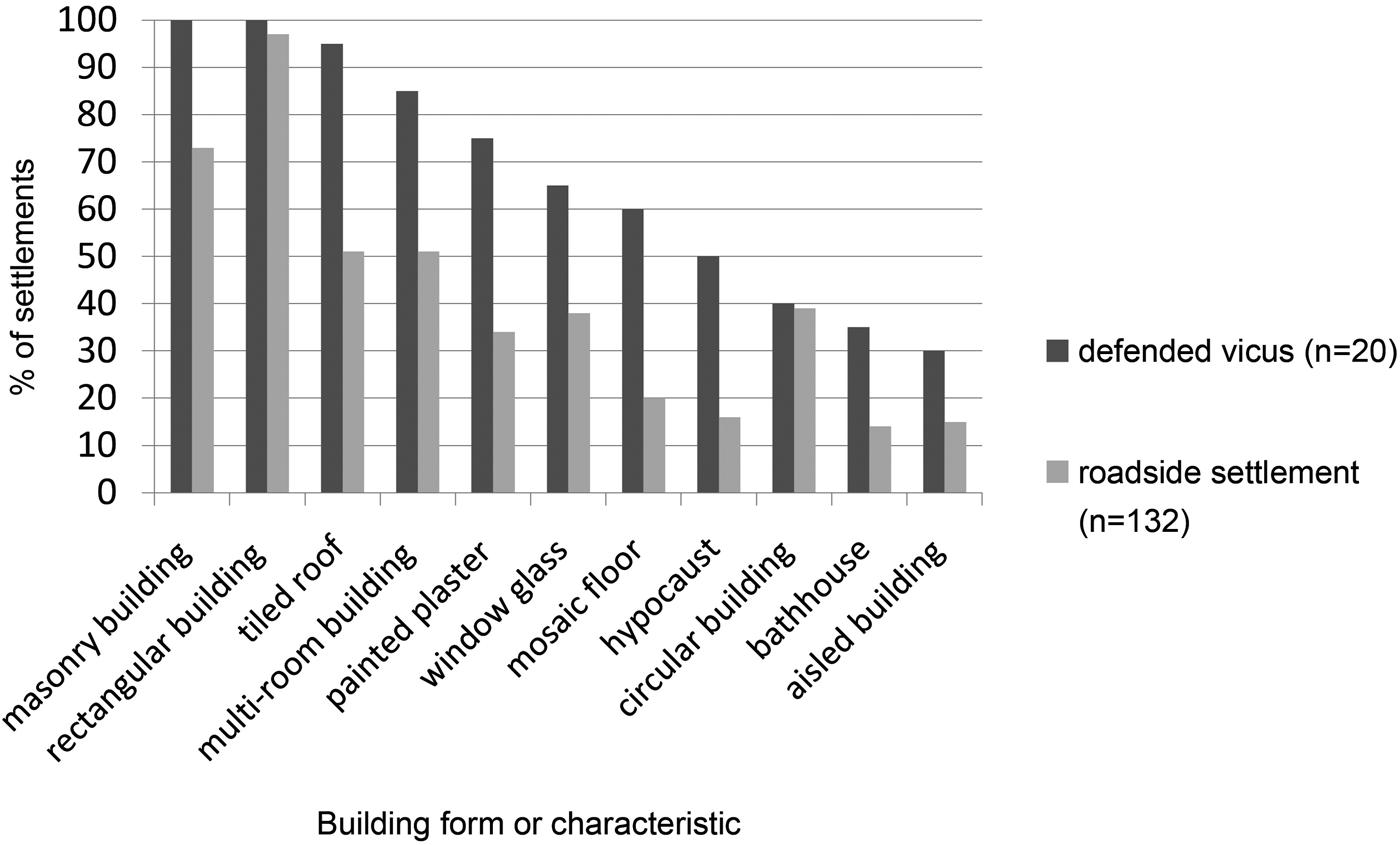
There is a considerable degree of architectural diversity within Romano-British nucleated settlements, demonstrating the broad social and economic spectrum of their population, as well as regional and site-specific traditions.Footnote 139 Nevertheless, in the sample of such settlements included within the Roman Rural Settlement Project, there do appear to be some broad differences in certain aspects of architectural expression between defended and non-defended nucleated sites (fig. 2). Where buildings of any sort have been recorded, both forms of settlement are dominated by rectilinear structures, with much smaller (though similar) proportions having evidence for curvilinear structures. However, there is consistently greater evidence for defended sites having at least one building with higher levels of architectural elaboration, in terms of tiled roofs, painted plaster walls, tessellated floors, hypocausts, etc. In many cases, this may reflect the presence of a mansio building, and/or a bath-house, both of which appear to be more common in defended sites, though, as noted above, these are not all necessarily enclosed by the defences or even contemporary with them.Footnote 140 There are also a number of examples (e.g. Alcester and Rochester, along with Kenchester in Herefordshire) of defended settlements with apparently wealthy domestic houses, similar to those found in most larger towns; however, in reality the interpretation of such structures as domestic dwellings is not always straightforward, and some may be hard to distinguish from more ‘official’ buildings such as mansiones. Of course there are also many examples of more elaborate buildings within undefended roadside settlements, such as the ‘villa-like’ buildings at Stanwick, Northants., and Camerton in Somerset, but these do appear on the whole to have been less common than at defended sites.
Comparison of architectural characteristics within defended and undefended nucleated settlements.

One useful method of attempting to understand the relative status and function of different types of settlement is through comparison of finds and environmental assemblages, both in terms of variety and quantity.Footnote 141 This was attempted to some extent within the three volumes of New Visions of the Countryside of Roman Britain, where, by using data from large numbers of settlements, relatively clear distinctions between nucleated settlements, villas and different forms of farmstead were demonstrated.Footnote 142 In Volume 1 such analysis was undertaken by region, though the data from defended vici were not yet available.Footnote 143 fig. 3 reproduces fig. 5.46 of that volume, concerning object types present in different settlement categories within the Central Belt (extending westwards from the Fens to parts of Somerset and South Wales), with the addition of data from 11 defended vici from the region. While there are many caveats that must be reiterated — notably the relatively small size of the sample and the selection of mostly more extensively excavated and substantial vici — it does appear that such settlements were more likely to have a wider range of object types, perhaps relating to a broader social and economic base. Coins are virtually ubiquitous at all site types in the region except farmsteads; there are more fundamental differences with most other categories, such as personal objects. The notably higher presence of objects associated with security, lighting and recreation in defended vici has already been highlighted in Volume 3, probably indicating a greater association with wealth and status along with increased insecurities in settlements of this type.Footnote 144 In his account of the social distribution of objects associated with writing, Brindle also noted the strong link with nucleated settlements along the road network, particularly defended vici, perhaps indicating a greater role played by such settlements in the infrastructure and bureaucratic management of the province.Footnote 145 The much greater incidence of military equipment and equine transport objects may also support such a suggestion, possibly associated with the mansiones that appear a more regular feature of defended sites (see discussion below).
Frequency of major artefact categories on different types of settlement in the Central Belt region.

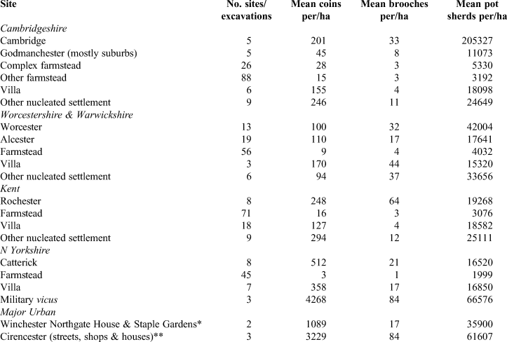
The simple presence or absence of objects does not necessarily make for the best comparison between sites, and so table 2 presents the mean numbers of three of the most commonly encountered finds — pottery, coins and brooches — by hectare of excavation from selected sites and regions. Although still a relatively crude measure and not without many methodological issues, until volumes of excavated soil are routinely recorded, this remains the most effective and simplest comparative tool for analysis of material culture.Footnote 146 In terms of the relative density of pottery recovery, Cambridge stands out as unusually high, particularly when compared with nearby Godmanchester, though the excavations with quantifiable data at the latter site were mostly those located within the suburbs, which may account for the reduced figure.Footnote 147 The relatively high density of pottery from Cambridge, which may even be an underestimate, may be partly due to the 100 per cent recording of features from earlier excavations; however, as Evans and Lucas have pointed out, it still seems a huge amount and quite disproportionate to the archaeology outlined in the Roman Cambridge volume.Footnote 148 Elsewhere, the pottery density from defended vici does not appear strikingly different from that from other nucleated sites, or indeed villas, though all, unsurprisingly, are much higher than for farmsteads.
COMPARISON OF THE DENSITY OF SELECTED FINDS CATEGORIES FROM SELECTED SITES AND SITE TYPES (*data from Ford and Teague Reference Ford and Teague2011; ** data from Holbrook Reference Holbrook2008)

Aside from pottery, coins are the most prolific object recovered from most Roman sites, and table 2 shows that all nucleated settlements in Cambridgeshire, Warwickshire, Worcestershire and Kent have fairly similar densities of coinage, with the exception of a lower density from Godmanchester, which, as with the pottery, is probably accounted for by the fact that the quantified data come from excavations in the suburbs rather than the main core. Chronology could also be a factor here, as areas lacking, or with low levels of fourth-century occupation will inevitably have much lower levels of coin loss. Nevertheless, the evidence overall suggests that in terms of the use of coinage there was no great difference between defended and undefended sites in these areas, and this correlates with Brindle's study showing similar coin distribution profiles between the two categories on a province-wide basis, reflecting their common role as service centres on the road network.Footnote 149 The relative density of coins from Catterick in North Yorkshire far surpassed that of the southern defended vici, almost certainly due to its strong military connections (see below).
Brooches were far less numerous than coins in Roman Britain, though their strong association with nucleated settlements, particularly those on the road network, has been demonstrated by Brindle, argued as partially reflecting the size of some of these settlements, and also because the regular interaction with others in such communities ensured a greater desire for presenting the self in particular ways.Footnote 150 As table 2 shows, their relative density between nucleated settlements is quite varied, though this is largely to do with whether or not sites had late Iron Age antecedents, this being the period when brooch use became common. This is seen, for example, with the high density of brooches at Cambridge, Worcester and Rochester, which all developed from Iron Age centres.
The evidence overall indicates that there appears to have been a broader variety of object types at defended settlements when compared with other roadside settlements, and there are particular categories of objects, such as those associated with literacy, transport and the military, which hint at a more official function within such settlements. This may be correlated with the higher incidence of ‘managed’ cemeteries at locations on the periphery of defended settlements, which could be indicative of more official involvement;Footnote 151 these patterns make sense given that it was almost certainly official impetus that provided the defences in the first place (see discussion below). In other ways, however, the differences are less marked, particularly in the overall densities of the more common types of artefacts, probably reflecting similarities in the overall population sizes of these settlements, as well as in access to and the desire for such objects.
The economic base of nucleated settlements varied on a site by site basis, though there are a few broad observations that suggest some shared role or status. Analysis in Volume 2 of New Visions indicated relatively consistent evidence for craftworking activities (metal-working, bone/antler-working, leather-working, glass production, etc.) within nucleated settlements, sometimes within specific ‘industrial zones’, with a particular emphasis on defended sites.Footnote 152 Nevertheless, with the exception of certain places such as Worcester, most industrial activity in these settlements does not appear to have been on any great scale, but rather catered for the needs of the resident population and of the through-traffic on the road system — these settlements essentially functioning as service centres.Footnote 153
In terms of their agrarian economy, it remains difficult to differentiate consumer from producer sites (i.e. those settlements which predominantly consumed rural resources and those that were farming settlements in their own right) and it is quite probable that some of the larger nucleated settlements, defended or not, belong in the former category, alongside the major towns and military sites of Roman Britain. However, it would appear that the great majority of nucleated settlements, where evidence allows, including most, if not all, of the case study examples, remained primarily agricultural in nature, on the basis of associated animal and plant remains, agricultural structures (corn-driers, granaries, etc.), their physical layout (animal pens, field-systems and integrated droveways) and agricultural tools.Footnote 154 Recent excavations around the walled vicus at Alchester in Oxfordshire have revealed a network of ditched boundaries seemingly conceived as a single integrated scheme during the early second century a.d.Footnote 155 Such a managed landscape, which included canalised water courses, would have been created with considerable effort, and points to the importance of providing agricultural capacity around such nucleated settlements, possibly in this case with some official stimulus. There are also strong indications of livestock breeding at some roadside settlements, as indicated by the presence of neonatal remains of domestic animals,Footnote 156 and the data from the sample of defended vici provide similar results.Footnote 157 Nevertheless, while most, if not all, of the nucleated settlements appear to have had some agricultural capacity, they may not have necessarily been major producers in the same way as certain complex farmsteads and villa estates. At the same time, although they were unlikely to have been major consumers, drawing in much of the produce of surrounding farming establishments in the same way as some of the larger towns, there were still the needs of the passing traffic, official and unofficial, to meet. Whether the community was expected to support both, or whether the official travellers, represented by the mansiones and mutationes, could also look elsewhere for resources is not known. The resident populations, however, were probably largely self-sufficient in terms of their agricultural needs. Moreover it remains very probable that the defended vici also played a more specialist role in the agricultural economy, in being primary collection centres for surplus arable crops and other goods produced in the vicinity, which were then exported further afield.Footnote 158
To conclude, whatever the distinctions between defended and undefended minor nucleated settlements, they can both be differentiated clearly from other, smaller rural settlement types, particularly farmsteads, reflecting a broad settlement hierarchy seen through the likes of architecture and the type, diversity and quantity of material culture. At the same time there were obvious close connections between all these settlement types. As we have seen above, it is less clear to what extent roadside nucleated sites would have served as local market centres through which objects flowed into the countryside, in addition to supporting the cursus publicus and other passing traffic, while also acting as conduits for the collection and distribution of agricultural produce, at least in areas where such sites were common in parts of southern, central and especially eastern Britain.Footnote 159
At the top of the settlement hierarchy lay the major towns of Roman Britain — the coloniae, civitas capitals and municipium. Comparative data from excavations in two of these towns, Cirencester and Winchester, in table 2 show them to be far above almost all of the other settlements, particularly in terms of coin density.Footnote 160 Recent studies of such towns in parts of southern Britain have highlighted their virtual isolation from other settlement types — comparisons of material culture in particular have suggested they were not socially or economically integrated with surrounding rural landscapes in the same way as smaller nucleated settlements, at least during the early Roman period.Footnote 161 Such a lack of engagement between large Roman towns and their rural hinterlands was also highlighted by Timby in terms of pottery supply in the west of England, while similar conclusions have been reached in studies of Silchester and Wroxeter.Footnote 162 This is not to say that all major towns can be grouped together as they show considerable variability in scale and levels of monumentality.Footnote 163 It is clear that even amongst the larger urban centres, London stands out as very different, not only in scale but also in terms of the quantity and variety of artefacts, and can only be loosely compared with the likes of Caistor-by-Norwich, the relatively small civitas capital of the Iceni (walled area of 14 ha), which recent excavations have indicated developed gradually during the second century a.d.Footnote 164 Nevertheless, despite this variety, the evidence to date suggests that such towns operated on a different level to other settlements in the province, and with their focus on provincial administration, they arguably exhibited closer connections to other, similar urban centres across the Empire than with surrounding rural communities. As noted above, such similarities in urban landscapes probably facilitated greater integration with the wider ideologies of the Roman Empire. The same may be said to some extent of military vici in the north and west of the province, which appear somewhat insular in being associated primarily with their own and other military communities, and with little apparent connection with those in the surrounding countryside.Footnote 165 Such disparity can clearly be seen in the very high artefact densities from the long-lived North Yorkshire military vicus settlements of Healam Bridge and Malton, shown in table 2. Although comparative data are very limited, the artefact densities here are only really paralleled within the civitas capital at Cirencester.
Ultimately, the evidence certainly indicates that a settlement hierarchy existed within Roman Britain, though there was not a straightforward linear progression of inter-dependent ‘site types’. Most major towns appear to have stood apart as ‘separate worlds’ at least until the later Roman period, while the myriad of smaller, roadside nucleated settlements probably helped to support the social and economic engine of the province's heartlands in the south. The defences that were erected at some of these settlements reflect certain differences in administrative and strategic functions, although it does not necessarily place them higher up any perceived hierarchy, or make them any more ‘urban’. Indeed, as we have seen, in some cases they were built at the expense of buildings used as part of the case for considering the settlement as urban.
DISCUSSION
The forty or so settlements identified as defended vici represent just under 20 per cent of all known nucleated settlements sited along the road network in Roman Britain, excluding the major towns and military vici (table 3). The majority of these defended sites lay within the central part of the province (the Roman Rural Settlement Project's Central Belt region), and on some of the major roads towards the principal concentrations of the military in the north-west and north-east (figs 1 and 4). Traditionally, most so-called urban defences have been suggested as either a response to threat, or as a sign of urban status and civic pride.Footnote 166 However, the reasons why particular settlements became defended were undoubtedly diverse and complex, as reflected in their varied scales, methods of construction and chronologies.Footnote 167
30 km radii around the defended vici of Roman Britain.

CHARACTERISTICS OF DEFENDED VICI IN ROMAN BRITAIN (italic = date uncertain)

The significant variation in the scale of defences has been well-observed (table 3),Footnote 168 though of course these rarely relate to the size of the wider settlement, as noted above.Footnote 169 At the lowest end of the scale were sites like Redhill (Uxacona), Shrops., on Watling Street, where defences encompassing less than 0.3 ha can best be viewed as forming a defended compound within the settlement rather than a defended vicus.Footnote 170 The defended area at this site was small even compared with the relatively modest defended circuits constructed at roadside settlements elsewhere along Watling Street, such as Cave's Inn, Mancetter and Wall, which ranged between 1.3 and 2.5 ha. These have been interpreted as late Roman official military installations, analogous with the many burgi of northern Gaul and Germany, or essentially as defended wagon parks for the cursus publicus.Footnote 171 Gould has argued, however, that the Watling Street sites (Redhill possibly excepted) were quite different from the continental burgi, which were designed as small, purely military defended zones, as they were generally much larger and have indications of civilian occupation within the defences, though the evidence for such occupation is often somewhat ambiguous.Footnote 172
The construction methods for vicus defences also varied between sites, some having just earthwork embankments (and typically ditches), while others had masonry walls with associated earth ramparts, the walls sometimes being a later addition to the defences (table 3).Footnote 173 Given the scale of most of the circuits, even building the earthwork ramparts would have been a considerable undertaking, with the masonry walling requiring significant resources (see discussion of Alcester walls above), probably beyond what was available to many of the communities and necessitating wider state involvement (discussed below).
It has long been recognised that there are particularly high numbers of Romano-British towns with early defences (pre-a.d. 200) when compared with elsewhere in the Empire. While only a few major cities (primarily coloniae such as Colchester and Gloucester) had defences dating to the first century a.d., around half of all defended vici have been suggested as receiving at least some defensive provision during the second century, typically at some point towards the end of this century, along with many of the large towns (table 3).Footnote 174 There is thus what appears to be a relatively concentrated period of defensive construction that has sometimes been related to the period of historical upheaval at this time, with further ‘waves’ of defence construction towards the end of the third century and in the mid-fourth century, again sometimes related to specific periods of historical unrest.Footnote 175 However, aside from the well-recognised problems of attempting to shoe-horn disparate archaeological evidence into historical narratives, there are also distinct issues with the chronological phasing of many urban defences, as previously noted by Wacher.Footnote 176 A brief assessment for the current survey suggests that the majority (c. 66 per cent) of defended vici have poorly dated defences, dependent upon minimal stratigraphic and finds evidence, often from old excavations, or no dating at all in some cases (table 3), though these defences are still often grouped together chronologically, typically in the traditional ‘later second to early third century’ or ‘later third to early fourth century’ brackets. Even the chronology of defences at settlements with slightly more secure dating, including most of the case studies presented above, is rarely that precise, so that the building of defences at individual sites may have been far more spread out chronologically than has often been supposed. Further work with scientific dating and Bayesian modelling may help to clarify such details.
Not all vici provided with earthwork defences around the late second and early third century were subsequently enhanced with masonry defences in the late third or fourth century (though we should not overlook the possibility that further defensive circuits, either of earthwork or of masonry, remain to be discovered) (fig. 4). Whether this was because the earthwork defences were still thought to be effective or because the perceived need for building anew at the site in question had passed is extremely difficult to resolve. However, there is a degree of patterning which may support the second interpretation: two places, Chelmsford and Kelvedon, lie on the road between London and Colchester and in a region where settlement was in decline in the later third and fourth century, while Brampton, Norfolk, whose heyday appears to have been in the period between the mid-second and mid-third century, also lies in a region where coastal forts could provide protection.Footnote 177 Apart from Brampton there are no other defended vici in the East region. To the west, at Leintwardine and Whitchurch, the need for continued defence may also have passed by the late Roman period. But there are also major differences in the density and size of defended vici along the major roads. In comparison with the Antonine Itinerary,Footnote 178 we see significant changes in emphasis: no walled vici between London and Caistor-by-Norwich (via Colchester) on Itinera V and IX; between London and Chichester (via Winchester) on Iter VII; between Silchester and Caerleon (via Gloucester) on Iter XIII; or between Silchester and Exeter via Dorchester on Iter XV. On the other hand, whereas routes to the north out of London privileged St Albans and Watling Street (Itinera II, VI and VIII) or, very circuitously, Colchester and Caistor-by-Norwich (Iter V), by the late Roman period Great Chesterford, Cambridge, Godmanchester and Water Newton provided substantial and closely spaced defended circuits on a more direct route to the north from London. Indeed, whereas Whilton Lodge and Towcester on Watling Street with walled areas of, respectively, 5 ha and 11.25 ha were exceptional in the size of their defended circuits compared with the other walled vici (<3 ha) along Watling Street between London and Wroxeter, all walled vici between London and Lincoln except Ancaster (4 ha) were provided with circuits in excess of 5 ha. Indeed the total capacity of walled vici between London and Lincoln at c. 64 ha was more than twice that of the vici between London and Wroxeter (c. 27 ha). Although this suggests a perceived strategic necessity to give much greater protection to the eastern route between London and the northern frontier, the concentration of walled vici with a total defended area of c. 60 ha between Great Casterton and Great Chesterford, a distance of only some 90 km as the crow flies, is exceptional. These lie in the West Anglian Plain, an area where recent archaeobotanical research demonstrates a clear dominance of the cultivation of spelt, a crop vital to military supply, and which also includes the relatively large walled vici of Irchester (8 ha) and Towcester (11.25 ha) (see below).Footnote 179
Although there are a few areas within central and southern Britain which were not within 30 km of a defended vicus (fig. 4), when the defended larger towns are added, the coverage is almost comprehensive, with the addition of the coastal forts making little difference (fig. 5). It is perhaps not surprising to find gaps in the agriculturally poor and wooded areas of the Weald and the New Forest, but it is less easy to account for the still large area of the East region which remained more than 30 km from a defended major town, defended vicus or coastal fort (albeit that it includes heathland and marsh), other than that it is a region which sees a decrease in settlement numbers in the third and fourth centuries (fig. 5).Footnote 180 To speculate further, is it just a coincidence that some of the great late Roman treasure hoards — Hoxne, Mildenhall and Thetford — are found in this potentially unsupervised area? By bringing into the discussion the defended large towns of the province, a further reason for the decisions not to upgrade the defences of certain vici from earthwork to masonry can perhaps be seen, in that the larger towns were sufficiently close to provide that potential defensive role.
30 km radii drawn around the major towns, the defended vici and the coastal forts (blue) of Roman Britain.

Despite the variety in scale, form and date of the defences, there are some common factors in the earlier development of vici that may help to explain why some became defended and others did not. As seen from some of the case studies discussed above, certain defended sites would seem to have developed from Iron Age settlements, though the nature of any transition is often ill understood. The proportion of such sites with Iron Age antecedents (c. 35 per cent) is somewhat above the 26 per cent of other roadside settlements believed to have had such origins, though the disparity is far greater when it comes to early military establishments. Here, over 50 per cent of what would later become defended vici appear to have had some kind of military phase (forts or supply bases), while at many others, such as Cambridge, the evidence is equivocal. Although there are also undefended roadside settlements with military origins, these only formed c. 15 per cent of this site type and were particularly rare in much of the South and Central Belt regions.Footnote 181
A further possible indication of differences in nucleated settlements that may be related to the later establishment of defences lies in the presence of a mansio, an official posting station on the imperial communications network, or a mutatio, which provided a change of horses but no accommodation. In Black's study of the cursus publicus in Roman Britain, he argued that such official facilities were a major spur to the growth of surrounding settlement, possibly leading to them becoming places for tax collection and local administration.Footnote 182 The number of certain mansio buildings in Britain remains fairly modest, with the best excavated examples still at places like Godmanchester, Chelmsford and Catterick, and a clear example known from aerial photographs at Wanborough, Wilts., though many others have been postulated, as in Cambridge and Alcester discussed above.Footnote 183 In all, at just under half of all defended vici the presence of a mansio has been suggested, with greater or lesser certainty, while this declines to less than 10 per cent of other roadside settlements. Therefore, even though in quite a few cases the mansio building appears to have been destroyed or abandoned prior to the defences being built (e.g. at Wall, Catterick and Godmanchester), there appears to have been a close connection between the presence of such official facilities and the eventual provision of defences. Whether destroyed or abandoned mansiones were replaced in some way within the new defended circuits remains to be established.
The evidence overall suggests that there were certain settlements on the road network, perhaps in places of greater strategic value, that often had a first-century military presence and a subsequent official mansio establishment, and which at various times between the mid-second and mid-fourth centuries received defensive enclosures of varying scales and construction methods, often, but not always, around the ‘core’ area of existing settlement. Whatever the specific reasons that led to the creation of these defences, the responsibility for their initiation lay with the state rather than the individual communities, and it targeted settlements that, by and large, already had some measure of official interest. Indeed, as suggested above, there appears to be a strategic logic behind the choice of which settlements to defend. This correlates with the evidence from the finds data discussed above, where there were particular affiliations noted with certain object types associated with literacy, the military and transport.
One possible explanation, though certainly not the only one, for why these sites generated and maintained greater levels of official involvement may be their roles within state supply networks, particularly of agricultural produce that was so vital to the state. As already noted, the major concentration of defended vici lay in the Central Belt, which was the agricultural heartland of the province, particularly during the middle to later Roman period.Footnote 184 It has been suggested that the defences of such settlements may have provided secure places where grain could be collected and redistributed, either using fixed granaries or mobile grain stores (wagon trains) that could be temporarily assembled before moving on.Footnote 185 The general expansion of agricultural production in many parts of central Britain typically involved more extensive cereal cultivation, almost exclusively of spelt wheat in most areas, and increased scales of processing seen through the frequency of corn-driers and high density crop-processing waste deposits.Footnote 186 Such changing agricultural strategies lie within the context of falling numbers of farmsteads, and potentially population, in most areas, and perhaps the resulting reorganisation and expansion of some villa estates in order to fulfil the growing state demand for wheat. The changes would undoubtedly have involved increased systems of control over agricultural labour and resources, possibly using military detachments to oversee the supply network, perhaps based largely within the defended vici of the region.Footnote 187
Whether or not the protection of agricultural produce and resources was a primary reason for the erection of defences in the first place is, of course, uncertain, though in most cases such strategic economic considerations were probably higher up the agenda than any demonstration of urban status and civic pride. Indeed, where data allow, it seems that many defended vici reached their greatest extent during the mid-Roman period (second to third centuries a.d.; see table 3), and so any provision or embellishment of defences in the later Roman period often lay in the context of a settlement already reducing in size and density of occupation, as indicated by many of the case studies above. These have further demonstrated a clear correlation between the fortunes of the vici and those of the surrounding rural settlements — evidence for contraction of occupation at the former generally coinciding with a decrease in rural settlement numbers, suggesting that there was not simply a shift of population into such nucleated centres. Although there is evidence at a number of defended sites for the continued investment in relatively high status architecture (painted plaster walls, heated rooms, etc.), which may in any case be related to buildings of public/state function (e.g. ‘official’ accommodation), it is unlikely in such contexts that the communities would have had the desire or resources to invest in large defensive schemes for the sake of civic pride.
Ultimately, despite what appears to have been a greater degree of engagement from the state, perhaps relating to specific economic and administrative functions, most of these sites where we have more detailed information can still be seen as essentially large, agriculturally self-sufficient settlements, with economic roles linked to servicing traffic along the road system, similar to other roadside settlements. Some places, such as Alcester and Godmanchester, may have played more key roles in the agricultural system, perhaps as intensive estate/distribution centres. Although most would also seem to have had further economic functions and sometimes evidence for high-status occupation, they were not ‘urban’ in the sense of the contemporary major towns of the province/diocese. Indeed, they may have been increasingly relied upon as an important source of labour for maintaining agricultural production — the concentration of this labour within such settlements probably making it easier to exert control over them. In this context, the bioarchaeological study of the skeletons from Jesus Lane, Cambridge, noted above, is interesting, suggesting as it does that the people there had led tough working lives, seemingly more in line with data from other late Roman rural populations than those from urban centres.
AGENDA FOR FUTURE RESEARCH
It is clear both from the analysis above, and that contained within the three volumes of New Visions of the Countryside of Roman Britain, that large numbers of minor nucleated settlements developed after the Claudian conquest, and that these settlements are key to understanding subsequent social and economic developments in the province. Yet, although the past 30 years of developer-funded archaeology have significantly improved our understanding of many of these sites, there is still a great deal more work needed to get a firmer grasp on their varied roles, development and relationships with surrounding settlements, infrastructure and landscape features. Commercial archaeological work has generally been more focused on the extramural zones of many defended sites, and so the nature and status of intramural areas still remain obscure. A major problem is that most archaeological investigation within such sites has been at a very small scale, and so more detailed studies of individual settlements and their hinterlands through more extensive excavation are needed, taking account of chronology, region, scale and quality of excavation, analysis of buildings, etc., and collating all these data to produce more coherent accounts of their development.Footnote 188 Further in-depth analyses of the finds and environmental material are needed that will not only enable meaningful comparison with other settlements, but also between different areas within the same settlement, in order to better understand their spatial organisation and multi-functional nature. The mass of new evidence from some settlements should enable more advanced thematic studies of, for example, religious expression and burial customs within nucleated sites. The number of known burials in particular has increased with more excavations in the outer reaches of settlements, and these should be subject to detailed bioarchaeological analysis to enable the health of more populations to be compared with those of other rural and urban sites, furthering the work of Redfern et al. and Rohnbogner.Footnote 189 A substantial programme of isotope analysis on the skeletal material would also be extremely useful for assessing population mobility at such minor nucleated sites, and how this compared with urban and smaller rural sites.Footnote 190
CONCLUSIONS
Our defended vici represent a sample of those settlements which would have played a role as mansiones or mutationes supporting the cursus publicus across the road network of Roman Britain. Our best insight into the network, at least at one moment in time, is probably the Antonine Itinerary but, while a great many named places can now be linked to sites on the ground, only a very few have produced evidence which is consistent with their assumed role.Footnote 191 We are sceptical of the urban character of these settlements, noting that the provision of defences does not correlate with any other form of aggrandisement of the settlement. Indeed, open areas in which to muster troops or supplies appear to be a consistent feature of defended sites. From the limited evidence so far available, we are doubtful, too, of the extent to which they served as markets beyond meeting the needs (if indeed, they always did) of those using the road system. In line with continental scholarship our preference is to think of these roadside settlements as vici — villages, rather than towns, but also recognising that the very small defended settlements, such as those on Watling Street and the Fosse Way, are probably best regarded as burgi. In confronting the difficulty of the overall lack of urban attributes among our roadside settlements, we thereby establish a greater degree of distance between these and the (generally) larger towns and cities of Britannia.
Roadside settlements, whether ultimately defended or not, represent a coherent group for future comparative research and analysis. Settlements with an industrial or religious focus (agglomerations?) also present themselves as coherent groups for further research in a similar way. Given what we now know of their variety, an all-embracing ‘small town’ approach no longer seems appropriate.
ACKNOWLEDGEMENT
We are very grateful to Daniel Wheeler for preparing the illustrations.