1. INTRODUCTION
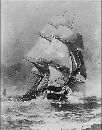
It is difficult to imagine an ocean–going vessel more beautiful than a classic tall sailing ship of the eighteenth or early nineteenth centuries, tacking into a stiff wind, with a full set of sails (See Figure 1). But as beautiful as such sailing ships were, so also were they dangerous. Historical records list hundreds of sailing ships and crews that went to sea, never to be seen or heard of again.
This scanned copy of a painting by Marshall Johnson depicts the frigate Constitution, a classic wooden-hull sailing ship, fully rigged and sailing in a brisk wind. (US National Archives).

Dava Sobel, author of the book Longitude, The True Story of a Lone Genius Who Solved the Greatest Scientific Problem of His Time, would have us believe that the common thread linking the disappearances of many, if not most, sailing ships during the age of sail (roughly the fifteenth through the early nineteenth centuries) was “the loss of their longitude at sea” (Sobel, Reference Sobel1995, p. 7). The underlying problem, she claims, was that there were no clocks that could keep accurate time onboard ships over the weeks to months it took to make ocean crossings, and not knowing their longitude led to disastrous endings for the ships and crews. Sobel was not the first to make this claim, see for example (Landes, Reference Landes1983; Lopez, Reference Lopez1986), and certainly not the last (Danson, Reference Danson2006; Bodenmann, Reference Bodenmann2010). But Longitude, buoyed by the enthusiastic endorsement of television celebrity Oprah Winfrey, quickly became a national and international best seller, and the basis for television shows watched (and apparently accepted as true) by millions.
It is not our intent here to review Longitude, but rather to present the conclusions that we reached in revisiting the challenges that confronted those who would explore remote regions, mount military actions and trade goods on a global scale using vessels propelled only by the wind. We found little or no evidence that the inability of seamen to determine longitude at sea was a major factor in the loss of ships and their crews. Indeed, because there were no accurate maps and charts available for most of the world, knowledge of the exact location of a ship, such as is now available from the Global Positioning System (GPS) would have been of little use to the captains in the age of sail.
The real problem was simply that both coastal waters and the open oceans were dangerous environments for ships powered only by the wind; without an on-demand self-contained source of propulsion, sailing ships were at the mercy of too little or too much wind, wind blowing from the wrong direction, currents, and heavy seas. And because sailing ships were so slow, taking weeks or months to make ocean crossings, they were almost certain to run into poor sailing conditions during some portion of virtually every lengthy voyage.
2. SAILING SHIPS OF THE FIFTEENTH TO EARLY NINETEENTH CENTURIES
Most classical sailing ships, even those built as late as the first half of the nineteenth century, were made almost completely of wood – except of course for the cloth sails, ropes, and a thin copper, lead, or zinc sheathing that protected the exterior of the hull from infestations of wood-boring worms. The materials, as well as the facilities available in the shipyards before the development of heavy machinery, limited the overall size and weight of the ships built. Most ranged from 25 to 50 metres in length, were 7 to 10 metres across the beam, had drafts of 3 to 4 metres, and their burdened weights were a few hundred tons.
The HMS Bark Endeavor, captained by James Cook on the first of his three voyages of discovery (to Polynesia, New Zealand, and Australia) from 1768 to 1771, was only 32 metres in length, 8·9 metres across the beam, and had a draft of about 4 metres with a fully burdened weight of 368 tons. The HMS Beagle, captained by James FitzRoy during its famous 1831 to 1836 voyage on which Charles Darwin served as the ship's naturalist, was even smaller than the Endeavor, only 27·5 metres long, 7·5 metres across the beam, with a draft of 3·8 metres and a burdened weight of 240 tons (Paine, Reference Paine2000).
Designs of ocean-going sailing ships differed somewhat from nation to nation, and evolved with time, but most had two to four masts. By the eighteenth century the masts were often as tall or taller than the ships were long, reaching heights of 35 to 40 metres, and could be rigged with dozens of sails of different sizes and shapes to deal with different wind and sea conditions. Still, the average speed of a fully rigged sailing ship was only about three to five knots (one knot is equal to one nautical mile (1·85 kilometre) per hour), with top speeds reaching eight to ten knots (Winfield, Reference Winfield2007).
Even sailing at speeds of only a few knots in moderate seas, sailing ships were subjected to strong torsional (twisting) stresses, caused by the large offsets between the forces acting on their hulls (drag, impacts of waves, shifting of freight) and the driving forces of the wind, captured by the sails and coupled to their hulls by the masts and rigging. Tacking into the wind, their hulls creaked and groaned with every twist, eventually developing leaks that required regular repairs. But structurally, the ships were surprisingly rugged— often surviving 100 to 150 kilometre per hour winds and 15 to 25 metre high waves. It was not unusual for them to stay afloat even after being run hard aground.
The Endeavour ran aground on the Great Barrier Reef during Cook's first voyage. The crew was able to free the ship, temporarily patch the hull, and sail to Batavia, in the Dutch East Indies, for repairs. The Beagle's primary mission was to map the coastlines and chart the coastal waters of Patagonia. Two years into the mission it was discovered that a piece of the secondary copper keel had been knocked off. Captain FitzRoy intentionally grounded his ship at the mouth of the Santa Cruz River in Argentina, laid it on its side, and worked during low tide to make the necessary repairs (Stone, Reference Stone and Stone1980).
3. REACHING THE OPEN SEA AND RETURNING TO PORT
The first challenge that the captain of a sailing ship faced when setting out on any voyage was simply making his way out of port into the open sea. Even sailing out of a well developed port could be like running a gantlet, requiring the captain to manoeuvre his ship through narrow inlets and channels, or along kilometres of rugged coastline, while dealing with such problems as strong currents, capricious winds, rain squalls, fog, shifting sand bars, or perhaps even sudden encounters with other ships departing or making port.
In 1831, after waiting for weeks in Plymouth, England, for favourable weather, the HMS Beagle set out on its historic five-year journey around the world. Sailing with a light northwest wind and a master onboard to provide expert knowledge of the local waters, the ship hit a rock just off Drake's Island. Captain FitzRoy managed to free-up the ship, but before the Beagle made it twenty kilometres out to sea a gale blew in from the southwest, and FitzRoy decided to return to port and await more favourable weather to make a new start (Stone, Reference Stone and Stone1980).
FitzRoy knew that he was fortunate to escape hitting the rock with no injuries and only minor damage to his ship. As a lieutenant, he had served on the HMS Thetis. Sailing out of Rio de Janeiro on December 4, 1830, the Thetis was forced to tack against a southern wind. Running under full sails the ship was making an estimated nine knots when it encountered a fast moving squall. Within minutes the visibility dropped to less than a ship's length. Suddenly the shear rock cliffs of Cape Frio appeared dead ahead. There was no time to change course and the ship crashed headlong into the cliffs. All three masts were broken and crashed down on the deck, crushing several members of the crew. Fortunately the boatswain succeeded in throwing a rope into the rocks and most of the crew was able to escape the sinking ship. Still, 25 perished (Stone, Reference Stone and Stone1980).
Making anchorage in foreign ports, or returning to home port, could be every bit as hazardous as setting out on a voyage. In 1707, Admiral Sir Cloudesley Shovell led his fleet to disaster by sailing into the Scilly Isles, just 30 kilometres off the southwest tip of England. Four ships and the lives of more than 2000 sailors were lost. Sobel, (Reference Sobel1995) asserts that this disaster demonstrated the urgent need for a way to determine longitude at sea. Perhaps, but only an all-weather navigational system could have prevented the disaster. Admiral Shovell and his fleet had been sailing in fog and overcast skies for twelve days, unable to make astronomic observations or sight known landmarks. Trying to make port under such conditions was foolhardy.
4. NAVIGATING THE HIGH SEAS WITHOUT A MARINE CHRONOMETER
Centuries before the invention of the marine chronometer, even before the first voyage of Christopher Columbus to the West Indies, captains of sailing ships practiced the art of navigation using a compass to determine direction, various means to estimate the speed of their ship through the water, astronomical (celestial) observations, indicators that land was nearby (such as the presence of birds and changes in the colour of the water), sightings of land (with or without the aid of a telescope) and sometimes even by making soundings with a weight and rope. These techniques are often lumped together under the heading of dead reckoning.
It is true that the uncertainty in the location of a sailing ship navigated by dead reckoning tended to grow with time at sea. However, Sobel's pronouncements that “…sailors throughout the ages of exploration had been literally lost at sea as soon as they lost sight of land,” and that “For the lack of a practical method of determining longitude, every great captain in the Age of Exploration became lost at sea despite the best available charts and compasses. From Vasco da Gama to Vasco Nunez de Balboa, from Ferdinand Magellan to Sir Frances Drake – they all got where they were going willi-nilly, by forces attributed to good luck or the grace of God” (Sobel, Reference Sobel1995, p. 7) are pure hyperbole, unsupported by facts.
Vasco da Gama, Vasco Nunez de Balboa, Ferdinand Magellan, and Frances Drake, and many other captains including Christopher Columbus, were skilled in the art of dead reckoning and to claim that they were “literally lost at sea as soon as they lost sight of land” is essentially equivalent to declaring anyone who has less than 20–20 vision blind. The very successes of these renowned captains in exploring the far corners of the world, discovering previously unknown lands, and returning safely to their home ports after months or even years at sea, belie Sobel's assessment of their navigational skills.
5. THE DANGERS OF SAILING THE OPEN SEAS
With no source of on-demand power, pure sailing ships were susceptible to both too weak and too strong winds. Able to carry only limited supplies of food and water, becoming becalmed and waiting for days or weeks for the wind to freshen, was perhaps a seaman's worst nightmare. And for good reason; the longer they were at sea, away from supplies of fresh fruits and vegetables, the more danger they were in of contracting scurvy.
At the opposite end of the spectrum were the high winds and rough seas that often seemed to come out of nowhere and suddenly descend on a ship with frightening ferocity. In a matter of minutes captains were faced with “a dilemma as old as the sail itself” (Mitchell, Reference Mitchell1966, p. 70); caught with even a modest set of sails deployed, a ship could quickly be overpowered, broach, and be immediately placed in danger of swamping or capsizing. There were no satellites to monitor the weather, or radios on which to receive bad weather warnings. The captains of sailing ships were left to read the signs of approaching bad sailing weather on their own, and what we have learned about global weather patterns over the past two centuries goes a long way toward explaining why so many sailing ships were lost at sea.
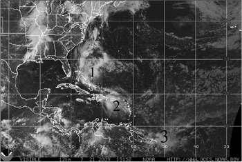
In the Atlantic, for example, during the period from the beginning of June until the end of November, six full months out of each year, tropical disturbances and storms develop off the west coast of Africa and move in the general direction of the Caribbean Sea. It is not unusual today for images collected by weather satellites to display three or four storms following one after another across the Atlantic, only to fan out as they approach the West Indies and encounter varying upper atmospheric steering winds (See Figure 2). The frequency of these storms and the slow speed of sailing ships made it nearly impossible for vessels to make the long voyage from Europe to the West Indies during hurricane season without encountering at least one or two strong storms. Caught up in a full-blown hurricane, a ship could be battered for days or even weeks. Sailors could be washed overboard, crushed by broken masts or yards. Rogue waves could over-wash the deck, flood the lower compartments and sink the ship at sea, or the ship could be driven onto a reef or island and destroyed.
This image from a National Oceanic and Atmospheric Administration (http://wwwnhc.noaa.gov/gifs/pastprofileAT.gif) weather satellite shows three small storms moving northwestward toward the Caribbean Sea. On average, each year ten storms develop into named tropical storms and six reach hurricane status.

Because of the favourable flow of the Gulf Stream and the prevailing wind patterns in the north Atlantic, ships often returned to Europe from the West Indies or Central and South America by sailing close ashore along the eastern coast of the North American Continent. Many sailing ships met disaster along this route. We now know that, particularly during the winter months, strong nor'easters (macro-scale storms that develop along the east coast of the United States and Canada when low pressure fronts bring frigid Arctic air masses south and they collide with the warmer waters of the Gulf Stream, most commonly between 30 and 35 degrees north latitude) can produce hurricane force winds and whip up heavy seas that could severely damage or destroy sailing ships.
Sailing into the Arctic region north of North America was a particularly dangerous undertaking, not only because there were no accurate maps locating the many islands in the region, but also because winds could suddenly move free-floating masses of ice, cutting off open water and trapping a ship. Or, the sudden onset of winter weather could cause the sea surface to freeze before a sailing ship had time to make its way to the open sea. More than one whaling expedition and fur trading voyage ended in tragedy when a ship struck ice and sank in the icy waters, or became trapped in the ice and the crew froze to death during the long winter (Lopez, Reference Lopez1986).
Reaching the Pacific Ocean from Europe by sailing through the dangerous Arctic waters was attempted only because other routes were longer and might prove equally dangerous. Sailing south from Europe and around the tip of South America to reach the Pacific, entailed crossing both the hurricane belt and the equatorial doldrums, just to reach Cape Horn. Rounding the Cape required sailing through some of the most tumultuous waters on the planet. And even after reaching the Pacific, sailing ships had to deal with typhoons and other storms that could be just as lethal as storms in the Atlantic Ocean.
In 1741 Commodore George Anson's fleet of six warships and two supply ships headed to Manila, rounded the Cape and was caught up in severe storms that lasted for nearly two months. The crews suffered from scurvy – six to ten died each day. When the storms finally abated Commodore Anson, aboard the HMS Centurion, found that his ship was just west of Tierra del Fuego, at approximately 53 degrees south latitude. He decided to head for Juan Fernandez Island, which was located off the coast of Chile, at 35 degrees south latitude. Reaching the correct latitude, but being unsure of his longitude, Anson wasted several more days sailing west, east, and again west before finding the island and making port.
According to Sobel, “The two weeks of zigzag searching for the island had cost Anson an additional eighty lives…then [Anson] watched as the scourge picked off his men one by one…until more than half of the original five hundred were dead and gone.” (Sobel, Reference Sobel1995, p.12). It is, of course, impossible to know how many of the sailors who died might have survived had the months-long journey been shortened by two weeks, but there seems to be no basis for Sobel's claim that “…a grand tragedy unfolded, founded on the loss of their longitude at sea.” (Sobel, Reference Sobel1995, p. 17). At worst, the uncertainty in longitude made an already dire situation worse.
After resting and replenishing his provisions, Commodore Anson resumed his mission. Sailing on toward Manila, the Centurion managed to intercept and capture a number of Spanish merchant ships, and to raid coastal settlements. After sailing to Macau to refit, the Centurion returned to the Philippines where it fought a battle with the 36 gun treasure galleon Nuestra Senora de la Covadonga (Winfield, Reference Winfield2007). Anson captured the Covadonga and his crew sailed both ships to Canton, where he sold the Covadonga, refitted the Centurion, and set sail around the tip of Africa and back to England, arriving home on June 15, 1744. The Centurion was the only ship of the original fleet to make it back to home port, but even without a chronometer onboard and having run into terrible storms and fighting battles at sea, Commodore Anson managed to find his way to ports on the opposite side of the Earth to obtain the services and supplies he needed to complete his mission and return home (Paine, Reference Paine2000).
Anson's attacks on the Spanish merchant ships point out another problem that could prove more dangerous to sailing ships, during certain periods of time and regions of the world, than the forces of nature or the occasional navigational error. The on-again off-again political relationships among the European nations competing to build global empires, particularly England, France, and Spain, resulted in commercial ships being attacked on the high seas by military ships, pirates, and privateers (pirates thinly veneered with authorization from the crown). Ships thought to be carrying gold, jewels and other riches were highly favoured targets, but even ships dispatched purely for scientific research were subject to attack by military ships during periods of war (Carter and Carter, Reference Carter and Carter2006).
6. REDUCING THE LOSS OF LIVES, CARGOES, AND SAILING SHIPS AT SEA
During the seventeenth century a number of European nations began systematically to build lighthouses to warn ship captains of particularly dangerous coastal features and enable them to update their positions while still at sea. Sporadic efforts were also made to chart troublesome coastal waters, but there were hundreds of ports and hundreds-of-thousands of kilometres of coastlines around the globe. And not only was there little or no international cooperation, but different industries and competing companies within the same nation often refused to share knowledge of the waters their ships sailed regularly.
In the aftermath of Admiral Shovell's disaster, there was increasing pressure on the British government to take actions to make travel at sea safer. In truth, there was not a lot that could be done until a better means of propulsion for ships could be found, but some show of action was needed and on July 8, 1714, the British Parliament passed the Longitude Act.
The Longitude Act established the Commission for the Discovery of Longitude at Sea, more commonly referred to as the Board of Longitude, and provided for three prizes based on the accuracy of the longitude measurement: £20,000 for one-half degree, £15,000 for two-thirds degree, and £10,000 for one degree (Sobel, Reference Sobel1995). Sobel argues that the British Parliament was prompted to pass the Longitude Act because of concerns that the very fortunes of the nation hung on finding a solution to determining longitude at sea. But this is hard to reconcile with the fact that seventeen years later, long before the problem of determining longitude at sea had been solved, and knowing full well the extreme dangers of sailing through the Arctic waters, the British Admiralty established a £20,000 prize (equal to the longitude prize) for the discovery of a Northwest Passage – a sailing route passing north of North America to the Orient. And some years later a second prize of £5,000 was added for the first ship to sail within one degree of the North Pole, as well as a third prize of equal amount for the first ship to reach one hundred and ten degrees west longitude by a northern route (Lopez, Reference Lopez1986).
Regardless of questions about the motives of Parliament, members of the Board of Longitude took their charge seriously and turned to Isaac Newton for advice and guidance. And Newton took valuable time from his scientific work to review the potential solutions that were then known to the longitude problem. He started with the conceptually simplest method, measuring the altitudes of celestial objects, noting that it required an accurate clock which “…by reason of the motion of the ship, the variation of heat and cold, wet and dry, and the difference of gravity in different latitudes, such a watch [clock] hath not yet been made.” (Sobel, 1995, p. 52). But he went on to outline other astronomical methods based on the relative positions of celestial bodies that had been worked out.
Lunar occultations, when the Moon crosses between an observer and a celestial object (star, planet, or minor planet), were routinely observed by astronomers to determine longitude at permanent and temporary land-based observatories. But with the limited aperture telescopes that could be used in hand-held instruments, there simply were too few occultations of sufficiently bright objects for the method to be made practical for navigating at sea. However, the same basic idea could be implemented in a much more robust manner, simply by measuring the angular separations, referred to as lunar distances, between the Moon and bright stars, planets, or even the Sun. In practice this method would require the development of specialized instruments and significant observing skills, but if the Moon was up and the skies were clear, there would nearly always be a few bright identifiable celestial objects about that could be used to determine longitude at sea.
It is clear from Newton's overview that the problems that remained to be solved before astronomical observations could be used to determine longitude at sea were not scientific (astronomers knew well how to make the required observations and calculations) but rather, practical and technological. Practically speaking, astronomers needed to collect many thousands of observations to prepare ephemerides for the celestial bodies necessary to navigate the ships globally. Technologically speaking, accurate clocks (marine chronometers) were needed to enable observations of the altitudes of celestial bodies, already routinely made to determine latitude, to also be used to determine longitude. Or alternatively, there was a need to develop improved observing instruments and procedures to measure accurately the angular separations between celestial bodies (such as the Moon and stars) from which longitude could be derived using existing clocks (watches).
7. SOLVING THE LONGITUDE PROBLEM
The Board of Longitude was seeking a practical every-day solution to the problem of determining longitude at sea. It most certainly would have preferred an inexpensive all-weather instrument that could directly display longitude, much as the mariner's compass displayed direction. Celestial navigation depended on being able to observe the Sun, Moon, planets, or stars and therefore was decidedly not all-weather. Still, even infrequent position updates during long intercontinental voyages that could take months to complete would enable ship captains to limit the accumulation of error in their dead reckoning, and be a significant improvement in navigation at sea.
From a practical point of view, for a method to find wide usage by both commercial and military vessels, it had to be based on an instrument, or instruments that could be built in large quantities, at reasonable costs, and that could be operated by personnel with moderate observing and computing skills after limited training. Again, the most obvious choice among the proposed methods of celestial navigation was that based on measuring the angular altitudes of celestial bodies above the horizon with an instrument such as a sextant, and using an accurate clock to relate the apparent local hour angle to the Greenwich Meridian, or another reference meridian.
In 1730 John Harrison prepared a preliminary design for a clock that he thought could be made to keep time accurately enough to facilitate the use of astronomical observations to determine longitude at sea. We will not recount the details of Harrison's work and his increasingly acrimonious relationship with certain members of the Board of Longitude here; interested readers may find detailed accounts in (Landes, Reference Landes1983; and Sobel, Reference Sobel1995). Suffice to say that for some four decades John Harrison worked continuously to develop a clock that would meet the approval of the Board of Longitude. Finally, his fourth clock, designated H4, successfully completed sea trials in 1764, and the Board offered him half of the Longitude Prize, £10,000 when and if he delivered all four of his clocks and the details of their designs, and an additional £10,000 if he would supervise the building of two copies of H4. The Board also hired Larcum Kendall to make an exact copy of H4. Both Kendall and Harrison completed copies of H4 in 1770, the former designated K1 and the latter H5.
8. NAVIGATING THE HIGH SEAS WITH A MARINE CHRONOMETER
With the approval of H4 by the Board of Longitude it may appear as though the problem of determining longitude at sea was solved. After all, according to (Sobel, Reference Sobel1995, p. 99) “this device [clock] of Harrison's had all the complexity of the longitude problem already hardwired into its works. The user didn't have to master math or astronomy or gain experience to make it go...In an earlier era, Harrison might have been accused of witchcraft for proposing such a magic-box solution.” Unfortunately, that is pure fantasy! The only complexities “hardwired” into the workings of Harrison's clocks were those mechanical contrivances intended to make them display the passing of time as accurately as possible, at sea.
But if a ship had a clock that accurately maintained the time of a port of known longitude, wasn't determining longitude at sea virtually a formality? Again, according to (Sobel, Reference Sobel1995, p.5), “Every day at sea, when the navigator resets his ship clock to local noon when the sun reaches its highest point in the sky, and then consults the proper home-port clock, every hour discrepancy between them translates into another fifteen degrees of longitude.” Sounds simple enough, but exactly how is the navigator supposed to accurately guage when the Sun reaches its highest point in the sky?
At latitudes north of the 66·5°N and south of 66·5°S the Sun does not even rise above the horizon during certain times of the year. Even in mid latitudes the path followed by the Sun is gently arched and it appears to move nearly parallel to the horizon for periods of several minutes before and after reaching its highest altitude. For an observer at thirty degrees latitude, when the Sun is at a declination of minus fifteen degrees, the difference in the elevation of the Sun at zero and one-half degree hour angle (the goal set for the longitude prize) is only one fifth of a minute, or 12 seconds, of arc – too small for the most skilled observer to discern using a hand-held instrument standing on the deck of a sailing ship.
The Sun (as well as the Moon, planets, and stars) is an acceptable target for determining latitude as it crosses an observer's meridian, precisely because the altitude remains nearly constant long enough that there is no need to know the exact time of the observation. For the same reason, it is a poor target for determining longitude. The uncertainty in setting a clock to local noon, based on directly observing the Sun at its highest point in the sky, would generally be much greater than that required to determine the longitude of a ship to within one-half of a degree, or even a few degrees.
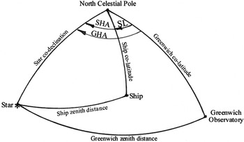
Having an accurate chronometer onboard a sailing ship did not negate the need to make astronomical observations to fix the ship's latitude and longitude at regular intervals. The Sun, Moon, planets, or brighter stars could be used, but to determine longitude accurately they had to be observed well east or west of the ship's meridian, when their altitudes were changing rapidly enough to estimate their local hour angles accurately (See Figure 3). Or, a combination of celestial objects, such as the Moon and bright stars could be used, as in the method known as lunar distances. In any case, making these astronomical observations required experience and at least enough knowledge of mathematics and astronomy to use the tables of a nautical almanac, prepared by knowledgeable astronomers.
This sketch shows the two astronomical triangles formed by the North Celestial Pole, a Star, and the zenith points of Greenwich Observatory and a Ship. The latitude and longitude of Greenwich Observatory are known, and the coordinates (right ascension and declination) of the star are tabulated in a nautical almanac. If the ship has a clock keeping Greenwich time, it is possible to calculate the Greenwich Hour Angle (GHA) at the time that the altitude of the star is observed onboard the ship. Assuming that the latitude of the ship is known, for example from observations of the altitude of the pole star (Polaris), the Ship Hour Angle (SHA) is easily computed. GHA minus SHA is equal to the Ship's west Longitude (SL).

When weather conditions prevented astronomical observations, the uncertainty of the position of a ship with an accurate clock grew just as rapidly as it did for a ship without an accurate clock. But, the captain of a ship with an accurate clock did not have to sight a known landmark, or return to port, to recover his longitude after an extended period of fog, clouds, or storms. As soon as conditions allowed astronomical observations to be made, he could get an astronomical fix and resume dead reckoning of his ship from that new position. There is no doubt that an accurate clock was a valuable addition to the tools used to navigate sailing ships, but it was certainly no magic-box solution.
Readers interested in learning more about the details of historical methods of navigating at sea, including examples of the mathematical and graphical procedures commonly used, may wish to read (Hill, Utegaard and Riordan, 1958).
9. IMMEDIATE IMPACT OF HARRISON'S CLOCKS
In 1772, forty-two years after John Harrison first revealed his preliminary design for a clock that he believed could keep time accurately enough to determine longitude at sea, Captain James Cook set sail in the HMS Resolution on his second voyage of exploration to the Pacific Ocean. Cook took K1 along and three additional clocks made by John Arnold.
During his first voyage Cook's entourage had made observations of the 1769 transit of Venus (when Venus passed directly between Earth and the Sun) from Papeete, Tahiti (Carter and Carter, Reference Carter and Carter2006), and he was well acquainted with the procedures for making precise astronomical observations, including lunar occultations and lunar distances. Cook was quick to realize that the new clocks he had onboard did an excellent job of keeping time over periods of weeks, and perhaps as long as a month or two. But just as with dead reckoning, the errors in the time kept by the clocks grew with time.
Cook had no reason to favour one method of determining longitude at sea over another. Rather than viewing the various methods of determining longitude (altitudes of celestial bodies, lunar occultations, and lunar distances) as competitive, he saw them as being complementary to each other. For periods of hours to a few days, dead reckoning served him well. Over periods of weeks, or perhaps as long as a few months, the time kept by K1 and Arnold's clocks enabled him to conveniently update his position (both latitude and longitude) based on relatively simple observations of the altitudes of celestial objects contained in his nautical almanac. And finally, by periodically making more complex lunar distance observations to reset his clocks, he was able to accurately find his longitude, virtually anywhere his exploration took him.
Cook's report on the performance of K1, the clock built by Kendall using Harrison's design, was both favourable and succinct. It had, he said “…exceeded the expectations of its most zealous advocate and by being now and then corrected by lunar observations has been our faithful guide through all vicissitudes of climates.” (Sobel, Reference Sobel1995, p. 150). And, should anyone harbour any doubts about his sincerity, Cook was more than pleased to take the same clock along on his third voyage.
10. LONGER TERM IMPACTS OF MARINE CHRONOMETERS
James Cook was obviously an extraordinary captain, and the fact that he could use a clock that was hand-built by an expert to determine his longitude at sea did not mean that a practical solution to the problem was in hand. It would take decades before clocks (marine chronometers) in the number needed and at affordable costs could be developed to supply the many military and commercial ships. And the captains of such ships had also to be trained in the proper maintenance and use of the chronometers, as well as learn to collect and reduce the required astronomical observations.
Nearly six decades after Cook's evaluation of K1 and John Arnold's three clocks, the Beagle set out with a total of 22 chronometers (six belonging to captain FitzRoy, one loaned by Lord Ashburnham, 11 provided by the navy and four provided by manufacturers for testing). Fitzroy housed his chronometers in a cabin dedicated just to the purpose of keeping accurate time onboard his ship. The chronometers were individually mounted on gimbals, in separate boxes. The boxes were arrayed on shelves and packed in sawdust to ameliorate the effects of jolts from impacts of the hull with the sea, as well as diurnal and other short period changes in the temperature of the clock room. Still, land based astronomical observations were made as opportunities presented themselves, to check the times and rates of the chronometers (Stone, Reference Stone and Stone1980).
Combining dead reckoning, astronomical fixes, and astronomical updates of the times and rates of an ensemble of several clocks proved to be a reasonably accurate and robust method of navigating ships during voyages of nearly any length. But the clocks and astronomic instruments required were expensive to purchase and maintain. The entire process was time consuming and still was not all-weather. Seamen continued to search for a simpler all-weather method to determine longitude at sea, eventually leading to the development of electronic navigation systems such as Loran-C and GPS.
11. THE UNITED STATES JOINS THE SEARCH FOR SAFER MARITIME OPERATIONS
In 1789 the United States established the Bureau of Lighthouses, which placed lighthouses under federal control. Eventually dozens were built and operated along both the Atlantic and Pacific coastlines, saving untold lives and ships.
In 1807 President Thomas Jefferson authorized the establishment of the Survey of the Coast (Dick, Reference Dick2003). The first mission of the new agency was to chart the port of New York. Eventually the agency evolved into the Coast Survey and then the Coast and Geodetic Survey, with responsibilities for establishing a national geodetic control system, mapping the major ports, and charting the nation's coastal waters.
In 1830 the US Navy established the Depot for Charts and Instruments, with responsibilities that included the purchase, maintenance, and rating of the chronometers used aboard US Naval vessels. Maintaining accurate time and setting the rates of the chronometers required the regular collection of astronomical observations, and the US Naval Observatory began operations in 1842. Seven years later, in 1849 the Nautical Almanac Office was established to provide American ships with ephemerides for the Sun, Moon, planets and stars needed for celestial navigation at sea, without relying on nautical almanacs purchased from European nations (Dick, Reference Dick2003).
After more than a decade of on-again-off-again debate and planning, in 1838 the United States decided to join in the international effort to explore the remaining unknown regions of the world. Lieutenant Charles Wilkes, then in charge of the Navy Depot, was assigned to lead an expedition consisting of six sailing ships, staffed with geologists, botanists, biologists, and mapmakers on a voyage of discovery to the Pacific Ocean.
During the four years of the expedition the Americans discovered and named Antarctica and charted dozens of previously unknown islands across the south Pacific, then sailed north along the Pacific coast of the United States where they surveyed the lower reaches of the Columbia River, before returning home by sailing around the Cape of Good Hope, completely circumnavigating the globe. The expedition lost one ship. The 36 metre sloop-of-war Peacock ran aground trying to enter the mouth of the Columbia River, and was eventually destroyed by the pounding waves. Fortunately, the crew was rescued (Philbrick, Reference Philbrick2003).
Lieutenant Wilkes and many others in the US Navy considered the 38·7 metre long sloop-of-war Vincennes to be one of the finest sailing ships ever built. Completed in 1826 the Vincennes had already circumnavigated the globe twice before it was assigned to Wilkes to serve as the flagship of the US Exploring Expedition. But, by 1842, when the Vincennes returned home, it was clear that the era of pure sailing ships was coming rapidly to a close.
In 1819, even before the hull of the Vincennes had ever been wet, the American ship SS Savannah, an hybrid sailing-steamer (side-wheeler) crossed the Atlantic from Savannah, Georgia, to Liverpool, England, in 18 days. The side-wheel configuration did not prove well suited for the open ocean, but the United States was a large nation with thousands of kilometres of navigable rivers, as well as the Great Lakes. Steam driven paddle-wheelers quickly came into use for moving freight and passengers relatively quickly and inexpensively between cities spread out thousands of kilometres apart along the Ohio, Missouri, and Mississippi Rivers.
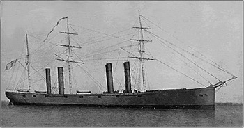
The principles of the screw propeller had been known since the time of Galileo, and it was only a matter of time before its many advantages for driving steamers would be recognized. Screw propellers created on-demand thrust directly coupled to the hull and nearly collinear to the drag forces opposing the motion of the hull through the water, dramatically reducing the torsional stresses placed on the ship. The development of heavy machinery in shipyards and the use of iron meant that much larger and stronger ships could be built, making them less vulnerable to the winds and waves of storms. By the 1870s steamers regularly provided safe and economical transportation of goods and passengers among the major ports of the world (See Figure 4).
Edited picture of the USS Wampanoag in 1868, a typical iron-hull hybrid screw-propeller steamer-sailing ship of that era. (US National Archives).

12. HARRISON'S PLACE IN THE HISTORY OF SCIENCE
John Harrison was a skilled and brilliantly innovative clockmaker. He was not a scientist, and he most certainly did not solve “the greatest scientific problem of his time.” In fact, to suggest that learning how to determine longitude at sea was the greatest scientific achievement of the eighteenth century is absurd, considering the advances in astronomy, chemistry, mathematics, and physics that were made during that same time frame – the first century of “Enlightened Science” (Gribbin, 2004, p. 241).
Nor did Harrison invent a “clock that would carry the true time from home port, like an eternal flame, to any remote corner of the world.” (Sobel, Reference Sobel1995, p. 8). What Harrison did do was to demonstrate that it was possible to build a clock that could keep time aboard a sailing vessel with an accuracy of a few seconds a day, during voyages of weeks to perhaps a few months.
Landes, (Reference Landes1983) describes the designs and inner workings of clocks H1 through H5 in some detail, before concluding that:
“…Harrison's sea clocks, for all their art and precision, are not the ancestors of the modern marine chronometers. Of Harrison's many ingenious inventions, only the maintaining power (the spring that keeps the clocks beating time while they are being wound) has been retained in later mechanisms. The rest were superseded by simpler solutions. His contribution, then, lay not in his devices but in the simple fact of their effectiveness: he demonstrated that the job could be done. He proved that a clock that could eliminate those last significant sources of error (friction, expansion and contraction due to temperature changes, and the influence of irregularities in the train) would indeed serve to tell the longitude.” (Landes, Reference Landes1983, p. 156).
Others would pick up the task of building marine chronometers in the numbers and cost required for them to become truly operational. But for proving that it was possible, John Harrison was awarded a total of £23,250 (about $4,000,000 today (Nye, Reference Nye2010)) and was elected a Fellow of the Royal Society of London. It is left to the reader to decide if John Harrison was treated fairly by the Board of Longitude.
13. CONCLUDING REMARKS
Long before Christopher Columbus's first voyage to the West Indies, the costs of going to sea in vessels propelled only by wind were well known – the frequent loss of lives, cargoes, and ships. But the fame to be gained by exploring remote corners of the world, the great wealth to be made through international trade and the national pride that came with building global empires were so alluring to individuals, companies and governments alike that there was no shortage of those willing to pay the cost.
It was well into the nineteenth century before exploration parties even visited, let alone mapped, the coastlines of all of the continents – not to mention the thousands of islands that dot the oceans. No responsible captain was willing to bet his ship and the lives of his crew on the assumption that the available maps and charts, and the estimated latitude and longitude of his ship, were accurate enough to safely navigate the globe, most particularly dangerous coastal waters. Navigating coastal waters was based almost exclusively on sightings of landmarks, not on coordinates (latitudes and longitudes).
The technological breakthrough needed to dramatically reduce the loss of ships and crews at sea was not a better means of navigation, but the development of a reliable self-contained source of propulsion. This came initially with the development of the steam engine, and later with the diesel engine, that could be coupled to a screw propeller which, in-turn, enabled the construction of much larger and stronger ships made of iron and later steel.