INTRODUCTION
The study of sea-level changes from the late Pleistocene to the Holocene is among the most important research areas in Quaternary studies (Clark et al., Reference Clark, Farrell and Peltier1978; Shennan, Reference Shennan1982; Nakada and Lambeck, Reference Nakada and Lambeck1989; Yokoyama et al., Reference Yokoyama, Okuno, Miyairi, Obrochta, Demboya, Makino and Kawahata2012; Okuno et al., Reference Okuno, Nakada, Ishii and Miura2014; Lambeck et al., Reference Lambeck, Rouby, Purcell, Sun and Sambridge2014; Khan et al., Reference Khan, Ashe, Shaw, Vacchi, Walker, Peltier, Kopp and Horton2015; García-Artola et al., Reference García-Artola, Stéphan, Cearreta, Kopp, Khan and Horton2018; Horton et al., Reference Horton, Shennan, Bradley, Cahill, Kirwan, Kopp and Shaw2018; Vacchi et al., Reference Vacchi, Engelhart, Nikitina, Ashe, Peltier, Roy, Kopp and Horton2018) because the cycle of eustatic sea-level changes has been more clearly recognised during the Quaternary period than prior (Lisiecki and Raymo, Reference Lisiecki and Raymo2005; Naish and Wilson, Reference Naish and Wilson2009).
Holocene relative sea-level changes exhibit spatial and temporal variability that arises mainly from the interaction of eustatic and isostatic factors (Clark et al., Reference Clark, Farrell and Peltier1978; Khan et al., Reference Khan, Ashe, Shaw, Vacchi, Walker, Peltier, Kopp and Horton2015). The records of Holocene relative sea-level changes in far-fields exhibit a mid-Holocene high stand, the timing (between 8 and 4 ka) and magnitude (between <1 and 6 m) of which vary among South America, Africa, Asia, and Oceania regions (Khan et al., Reference Khan, Ashe, Shaw, Vacchi, Walker, Peltier, Kopp and Horton2015). However, it is difficult to obtain quantitative sea-level data from tectonically active zones such as subduction zones. The coastal lowland of Japan is within such a zone (Fig. 1a); thus, relative sea-level changes reconstructed from late Quaternary sedimentary deposits incorporate tectonic effects (Yokoyama et al., Reference Yokoyama, Nakada, Maeda, Nagaoka, Okuno, Matsumoto, Sato and Matsushima1996, Reference Yokoyama, Okuno, Miyairi, Obrochta, Demboya, Makino and Kawahata2012; Sato et al., Reference Sato, Okuno, Nakada and Maeda2001; Tanabe et al., Reference Tanabe, Tateishi and Shibata2009; Tanigawa et al., Reference Tanigawa, Hyodo and Sato2013). In other words, through a detailed reconstruction of the palaeogeography and local tectonic effects after separating both, we may be able to better understand both sea-level changes and tectonics.
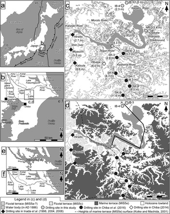
Maps showing: (a) the location of the study area in Japan; (b) the Kanto Plain; and drilling sites described in (c) the studies of Chiba et al. (Reference Chiba, Sugihara, Matsushima, Arai and Endo2016; SK-3–SK-9) and Inada et al. (Reference Inada, Ohama and Shimamura1998, Reference Inada, Saito, Ohama, Kaneko, Shimamura, Shimizu and Natsuaki2004, Reference Inada, Saito, Nirei, Nishimura, Ohama, Kaneko, Kaneko, Shimamura and Shimizu2008; Hirado, Miyauchi, and Katsuta) and (d) this study (IB-1, 3, 4, and NR-2). The contour interval in (c) is 10 m (Tani Reference Tani2015, Reference Tani2016) and the lake shoreline is based on the Jinsokuzu map created in AD 1886 (Iwasaki et al., Reference Iwasaki, Sprague, Koyanagi, Furuhashi and Yamamoto2009; National Institute for Agro-Environmental Sciences 2016). The map in (d) shows the geographic setting of the study area (modified from Sugihara, Reference Sugihara1970; Sugihara et al., Reference Sugihara, Kurozumi and Horikoshi2011) and contours representing the height of a marine terrace formed during Marine Oxygen Isotope Stage 5e (Koike and Machida Reference Koike and Machida2001). (e) Map showing the water body area during the Holocene transgression period based on Endo et al. (Reference Endo, Sekimoto, Takano, Suzuki and Hirai1983). (f) The modern water body area.

On the eastern Kanto Plain of central Japan (Fig. 1a and b), the vast lowland along the Tone River has yielded evidence of landform development and palaeoenvironmental changes caused by the Holocene transgression and the subsequent regression (Kikuchi, Reference Kikuchi1969; Ota et al., Reference Ota, Matsushima, Miyoshi, Kashima, Maeda and Moriwaki1985; Saito, Reference Saito1995; Saito et al., Reference Saito, Ikehara, Tamura, Moreno, Wallis, Kojima and Gibbons2016). During the Holocene transgression, the present-day lowlands along the middle and lower reaches of the Tone River (Fig. 1b) were covered by a shallow bay (Endo et al., Reference Endo, Sekimoto and Takano1982, Reference Endo, Sekimoto, Takano, Suzuki and Hirai1983), whereas during the subsequent regression, the area was characterised by lagoons and drowned valleys filled with marine mud. Moreover, during the Holocene, prehistoric human inhabitants (the Jomon culture during the early to late Holocene and the Yayoi culture during the late Holocene) left behind many shell mounds near contemporary shorelines (Yoshino, Reference Yoshino1998; Editorial Committee of History in Noda-shi, 2010; Masubuchi and Sugihara, Reference Masubuchi and Sugihara2010). The relationship between the palaeoenvironment and human activity have been actively studied (e.g., Masubuchi and Sugihara, Reference Masubuchi and Sugihara2010). Evidence of Holocene sea-level change is abundant on the eastern Kanto Plain (Endo et al., Reference Endo, Sekimoto and Takano1982; Ota et al., Reference Ota, Umitsu and Matsushima1990; Chiba et al., Reference Chiba, Sugihara, Matsushima, Arai and Endo2016). The topography of the southern Kanto Plain has also been strongly influenced by Quaternary tectonics (Sugimura and Naruse, Reference Sugimura and Naruse1954; Yonekura, Reference Yonekura1975; Matsuda et al., Reference Matsuda, Ota, Ando and Yonekura1978; Nakata et al., Reference Nakata, Koba, Imaizumi, Jo, Matsumoto and Takeshi Suganuma1980; Kaizuka, Reference Kaizuka1987; Shishikura, Reference Shishikura2003, Reference Shishikura2014; Hashima et al., Reference Hashima, Sato, Sato, Asao, Furuya, Yamamoto and Kameo2016; Noda et al., Reference Noda, Miyauchi, Sato and Matsu'ura2018); for example, the present height of the deposits associated with the Holocene high stand increases toward the southern Kanto. Therefore, to understand the formational processes of the geomorphic history in the Kanto area, it is necessary to reconstruct palaeogeographic changes resulting from both sea-level changes and tectonics.
Despite the importance of tectonics, the magnitude and timing of tectonic movements of the central to eastern Kanto Plain at a millennial scale are poorly understood mainly for two reasons (Kaizuka et al., Reference Kaizuka, Koike, Endo, Yamazaki and Suzuki2000). First, the central to northern Kanto Plain has been subsiding (Kaizuka et al., Reference Kaizuka, Koike, Endo, Yamazaki and Suzuki2000) and the pre-Holocene sediments and erosional topography formed during the last glacial maximum are covered by thick, marine sediments deposited during the Holocene transgression whereas the southern Kanto Plain underwent uplift. Second, the coastal environment and landforms have been greatly altered by human activities (Kaizuka et al., Reference Kaizuka, Koike, Endo, Yamazaki and Suzuki2000).
However, a long, narrow, inner bay, the so-called Palaeo-Kinu Bay (or Sea of Katori), formed in the eastern Kanto area during the transgression period (Fig. 1e; Endo et al., Reference Endo, Sekimoto, Takano, Suzuki and Hirai1983; Komatsubara et al., Reference Komatsubara, Ishihara, Ishihara, Kazaoka and Mizuno2017). The bay existed for a long time before disappearing (Fig. 1f), although it is estimated that the Palaeo-Kinu Bay contracted and desalinated during the regression. One theory states that the water body area remained until the fourteenth century (Oya, Reference Oya1969); however, the details remain unknown. Chiba et al. (Reference Chiba, Sugihara, Matsushima, Arai and Endo2016) analysed the diatomaceous record in cores (SK-3 and -4 and SK-6–9) collected at sites along the Kashima River south of Lake Inba and estimated the palaeotidal range at 7000 yr, inferred sea-level changes and the timing and height of the Holocene high stand, and estimated the effect of residual uplift during the last 8000 yr (Fig. 1c). The estimated uplift trend is consistent with the model of Okuno et al. (Reference Okuno, Nakada, Ishii and Miura2014). The crustal uplift trend over ~125,000 yr in the Kanto region suggests that tectonic movements have been approximately consistent during the past ~125,000 yr. Moreover, the uplift trend can be explained by crustal deformation owing to subduction of the Philippine Sea plate beneath the Kanto region (Fig. 1a and b; Hashima et al., Reference Hashima, Sato, Sato, Asao, Furuya, Yamamoto and Kameo2016; Noda et al., Reference Noda, Miyauchi, Sato and Matsu'ura2018). However, the area south of Lake Inba (including along the Kashima River) is tectonically active; thus, the standard sea-level curve is not necessarily applicable. Moreover, it is possible that the mode of vertical crustal movement varies between the southern and northern parts of the Lake Inba area. The present heights of the marine terraces (Koike and Machida, Reference Koike and Machida2001) suggest that the residual uplift rate differs between the upland area south of the lake and the low-elevation area around its outlet (Fig. 1d).
To assess in detail the effects of tectonics on the eastern Kanto Plain during the latest Pleistocene, we obtained four drill cores from the central and northern Lake Inba area and reconstructed the palaeogeography and relative sea-level changes by means of fossil diatom analysis and 14C dating. Using these data together with diatomaceous and 14C data from Obukai, an upland site south of Lake Inba (Fig. 1c and d; Chiba, Reference Chiba2014), we compared the rate of sea-level rise to that of the relative sea-level model calculated by Okuno et al. (Reference Okuno, Nakada, Ishii and Miura2014). We also compared the rate of sea-level rise to that of the Tokyo and Nakagawa lowlands (Fig. 1b, Endo et al., Reference Endo, Kosugi, Matsushita, Miyaji, Hishida and Takano1989; Ishihara et al., Reference Ishihara, Toshihiko Sugai and Hachinohe2012; Tanabe et al., Reference Tanabe, Nakanishi, Ishihara and Nakashima2015; Tanabe, Reference Tanabe2019), where the effect of crustal deformation during the Holocene is considered to have been small (Endo et al., Reference Endo, Kosugi, Matsushita, Miyaji, Hishida and Takano1989; Tanabe, Reference Tanabe2019).
GEOLOGICAL SETTING
The lowlands along the lower reaches of the Tone River are covered by Holocene sediments (Endo et al., Reference Endo, Sekimoto, Takano, Suzuki and Hirai1983; Sugihara et al., Reference Sugihara, Kurozumi and Horikoshi2011), but the distribution of marine and fluvial terraces at 20–30 m elevation, dating from Marine Oxygen Isotope Stage (MIS) 5a–5e, attests to gradual uplift occurring during the late Pleistocene and Holocene (Sugihara, Reference Sugihara1970; Kaizuka, Reference Kaizuka1987). In addition, Holocene sea-level changes have influenced the topography of the eastern Kanto Plain (Kaizuka et al., Reference Kaizuka, Koike, Endo, Yamazaki and Suzuki2000). During the Holocene transgression, many stream valleys that were incised during the last glacial period became filled by marine sediments, and coastal landforms were formed (Endo et al., Reference Endo, Sekimoto, Takano, Suzuki and Hirai1983). During the sea-level high stand, fluvial deposits blanketed the marine sediments, and lagoons formed that became lake basins following the ensuing regression. For example, Lake Kasumigaura (Saito et al., Reference Saito, Inouchi and Yokota1990), Lake Kitaura (Naya et al., Reference Naya, Tanimura, Kanai, Kumon and Amano2007), and Lake Tega (Kashima et al., Reference Kashima, Nemoto and Kobayashi1988) are former lagoons (Fig. 1b). Lake Inba, another former lagoon (Kusuda and Nirei, Reference Kusuda and Nirei1994; Sugihara et al., Reference Sugihara, Kurozumi and Horikoshi2011), has been divided by land reclamation into northeastern and southwestern parts. At present, its surface area is 11.55 km2, its average depth is 1.7 m, and its maximum depth is 2.5 m (Chiba Prefectural Environmental Research Center, 2016). The Kashima, Shin, Kanzaki, Moroto, and Teguri rivers flow into Lake Inba, and the lake drains from its north end into the Tone River (Fig. 1c and d). The present elevation of the lowlands around the lakeshore is ~12 m, and this lowland area is underlain by about 10–40 m of Holocene deposits (Sugihara et al., Reference Sugihara, Kurozumi and Horikoshi2011). From AD 1946–1968, reclamation works were carried out around Lake Inba (Takada et al., Reference Takada, Uwagawa, Asada, Sato and Kudara1971), and most of the reclaimed lands are now used for farming.
MATERIALS AND METHODS
Lithology and dating
We used samples collected from cores IB-3 and -4 (Fig. 1d and 2), which were obtained near where Lake Inba connects with the Tone River, from core NR-2 (Fig. 1d and 2), which was collected near the Daikatahanawa shell mound (Chiba et al., Reference Chiba, Kanauchi, Kamiya and Sugihara2011), and from core IB-1, which was obtained near where the Kashima River flows into Lake Inba (Fig. 1d and 2). Lithological characteristics of the cores were described, based on changes in grain size and colour of sediments, content, and conservation of biogenic material such as fossil shells and plants. The cores were subsampled first for 14C dating (Sugihara et al., Reference Sugihara, Kurozumi and Horikoshi2011) and later by us to obtain samples for diatom and grain-size analyses. We used the 14C age data reported by Sugihara et al. (Reference Sugihara, Kurozumi and Horikoshi2011) along with new 14C date obtained from IB-3 and -4 (Table 1). All dates were calibrated by using the database of Reimer et al. (Reference Reimer, Baillie, Bard, Bayliss, Beck, Bertrand and Blackwell2004) and the IntCal 6.0 program, and calendar ages and their 2-sigma range (cal yr BP) are used here. For dates obtained on marine materials such as shell, we assumed a value of 0 for the reservoir effect, ΔR (the difference between regional and global marine 14C ages; Stuiver and Braziunas, Reference Stuiver and Braziunas1993), because the correct value for this area is unknown.
Cross section along line A–B in Figure 1d.

List of 14C ages in this study. All elevations and calibrated dates are rounded to the nearest 10 cm and 10 yr, respectively. Tidal range showing sea-level index points; F, freshwater environment (non-tidal wetland); UIT, just below the marine limit and upper intertidal zone; IT, intertidal zone, ST, subtidal zone

Sand content
To assist observation of the core lithology, we measured sand content (%). The samples were collected from cores IB-1, -3, and -4 and NR-2 at 0.1- to 0.5-m intervals (88 samples from IB-3, 50 samples from IB-4, 20 samples from NR-2, and 52 samples from IB-1). The samples were pretreated with H2O2 and plant materials such as wood fragments were picked out. After the pretreatment, samples were divided into mud and sand by sieving through a 4-phi (0.063-mm) mesh.
Diatom analysis
Samples for diatom analysis were collected from cores IB-1, -3, and -4 at 0.1- to 1.0-m intervals (52 samples from IB-3, 32 samples from IB-4, and 38 samples from IB-1). Diatoms of core NR-2 have been reported by Chiba et al. (Reference Chiba, Kanauchi, Kamiya and Sugihara2011), so we also collected and analysed eight samples from core NR-2 and added the results to the reported data. The samples were pretreated with H2O2, and then the cleaned diatom frustules were mounted in Pleurax. Relative abundances of diatom species were determined by counting at least 300 valves under an optical microscope at 1000× using oil immersion. Diatom identifications were made and environmental conditions were interpreted by reference to Hasle (Reference Hasle1978), Krammer and Lange-Bertalot (Reference Krammer, Lange-Bertalot, Ettl, Gerloff, Heyning and Mollenhauer1986, Reference Krammer, Lange-Bertalot, Ettl, Gerloff, Heyning and Mollenhauer1988, Reference Krammer, Lange-Bertalot, Ettl, Gerloff, Heyning and Mollenhauer1991a, Reference Krammer, Lange-Bertalot, Ettl, Gerloff, Heyning and Mollenhauer1991b), Krammer (Reference Krammer2000), Witkowski et al. (Reference Witkowski, Lange-Bertalot, Metzeltin and Lange-Bertalot2000), Sawai (Reference Sawai2001), Nagumo (Reference Nagumo2003), Sawai and Nagumo (Reference Sawai and Nagumo2003), Idei et al. (Reference Idei, Osada, Sato, Toyoda, Nagumo and Mann2012), Watanabe et al. (Reference Watanabe, Tanaka, Reid, Kumada and Nagumo2013), Chiba and Sawai (Reference Chiba and Sawai2014), Chiba et al. (Reference Chiba, Nishimura and Ohtsuka2018), and Cocquyt et al. (Reference Cocquyt, Olodo and Abou2018).
Reconstruction of palaeoshorelines and sea-level changes
To reconstruct palaeoshoreline changes, we used diatom analysis results from cores IB-1, -3, and -4 and NR-2, along with previously reported results from Obukai (Chiba Reference Chiba2014) and cores SK-3–SK-9 (Fig. 1c and d; Chiba et al., Reference Chiba, Sugihara, Matsushima, Arai and Endo2016). We also used palaeoenvironmental changes along the Shin River, which flows into the western end of Lake Inba, reported by Inada et al. (Reference Inada, Ohama and Shimamura1998, Reference Inada, Saito, Ohama, Kaneko, Shimamura, Shimizu and Natsuaki2004, Reference Inada, Saito, Nirei, Nishimura, Ohama, Kaneko, Kaneko, Shimamura and Shimizu2008), in our reconstruction. In general, we used tidal flat sediments, which we identified by an abundance of diatom species considered to be tidal flat indicators (Chiba and Sawai, Reference Chiba and Sawai2014; Chiba et al., Reference Chiba, Sugihara, Matsushima, Arai and Endo2016) as a palaeoshoreline indicator, because tidal flats are typically in intertidal areas (at around mean sea level). These sea-level index points, however, have an error equal to the palaeotidal range. Pseudopodosira kosugii is a useful indicator diatom species for the upper limit of marine deposits (Tanimura and Sato, Reference Tanimura and Sato1997; Sawai, Reference Sawai2001), but this species is not always abundant in Holocene sediments in the northern part of the study area. Therefore, we determined the high-tide level (the upper limit of the tidal range) from the upper limit of the low-salinity diatom assemblage, which is typically found just below the upper marine limit, and the core lithology (in particular, the presence of peaty deposits). Where we could identify the high-tide level near the marine limit, we considered the tidal range to be 3.3 m (Chiba et al., Reference Chiba, Sugihara, Matsushima, Arai and Endo2016); otherwise, we assumed a tidal range of 6.6 m where we were unable to determine the upper and lower limits of the tidal range. We also used changes in the diatom assemblage type (freshwater, freshwater-brackish to brackish-marine, and marine) to identify changes in the depositional environment (Appendices 1–3).
Estimation of the subsidence rate
The mean subsidence rate was calculated from the amount of subsidence divided by the amount of time over which the subsidence occurred; this information was derived from the elevations and ages of each sea-level index point obtained by dating and diatom analysis in this study or simulated values from prior studies (e.g., Okuno et al., Reference Okuno, Nakada, Ishii and Miura2014). The mean subsidence rate was calculated from the following equation:
 $${\rm mean \; subsidence\; rate} = {{{E_1-E_2}}\over{T}} $$
where E 1 is the elevation of a sea-level index point or a simulated value, E 2 is the elevation of a sea-level index point or a simulated value, and T is the time period for which the subsidence was estimated by palaeoenvironmental reconstruction.
RESULTS
Palaeoenvironments inferred from the lithology and diatom assemblages of IB-3
Core IB-3 contained Holocene deposits (Fig. 3). The interval from 39.0–38.5 m consisted of peaty sediments (sand content 30–68%) overlying fine to medium sand from 40.0–39.0 m depth (sand content 65–79%). The sediments of the upper sandy muddy deposits consisted of sandy mud from 38.5–37.9 m depth; the interval from 38.5–37.9 m depth consisted of sandy mud (sand content 6–52%). The interval from 37.9–10.0 m depth consisted of mud, containing fossil shells, and that from 8.0–5.2 m depth also contained shell fragments (sand content 8–59%). The interval from 2.6–2.2 m depth consisted of peat and that from 4.1–3.8 m depth consisted of organic-rich muddy sand and a 1.2-m-thick coarse sand bed overlying a lower mud with an erosional contact (sand content 31–58%). An organic-rich sandy mud from 2.2–1.9 m depth with an erosional contact (sand content 2–24%) underlies an upward-fining sequence from medium to fine sand from 1.9–1.1 m depth. The natural sediments consisted of muddy sand from 1.1–0.9 m in depth; below the artificial fill occupied the uppermost 0.9 m.
Stratigraphy, diatom assemblages, and 14C ages in core IB-3.

In core IB-3, we identified diatom zones 1 to 5 in ascending order (Fig. 3). Zone 1 was characterised by freshwater diatoms such as Eunotia spp. and Planothidium lanceolatum and mainly sandy sediments; thus, it was interpreted as representing a freshwater environment. In diatom zone 2, freshwater diatoms decreased and freshwater-brackish, brackish-marine, and marine diatoms such as Amphora arenicola and Diploneis smithii increased in relative abundance. Lithologically, this zone was characterised by peat or organic-rich mud. Given the mixed diatom assemblage and lithology, this zone was interpreted as representing a muddy tidal flat environment. In diatom zone 3, marine planktonic diatoms such as Cyclotella litoralis and Thalassionema nitzschioides dominated and the lithology was very fine mud; therefore, this zone was interpreted as representing a subtidal inner bay environment. In zone 4, freshwater diatoms such as Staurosira construens and freshwater-brackish diatoms such as Pseudostaurosira brevistriata and Pseudostaurosira sp. increased; furthermore, the intertidal diatom Terpsinoë americana was recognised. Given the diatom assemblage and the mud or sandy mud lithology, this deposit was interpreted as representing a brackish water environment such as tidal flats. In zone 5, the relative abundance of brackish-marine species decreased to near zero, and freshwater-brackish species such as P. brevistriata and freshwater species such as S. construens increased. Lithologically, this zone consisted of sandy or peaty deposits. Therefore, zone 5 was interpreted as representing a freshwater or low-salinity marsh environment with a fluvial influence.
The tidal flat environment suggested by the lithologic and diatomaceous data of zone 2 indicates that mean sea level during the period 9090–8750 cal yr BP was at approximately 38.1 m core depth (elevation −36.3 m). A subtidal environment prevailed at the site from approximately 8750 to 4850 cal yr BP (8.5 m core depth; elevation −6.7 m). However, by 2660 cal yr BP (2.6 m core depth; elevation −0.8 m), the environment at the site was again tidal flats and thus was near mean sea level. During the period 1870–1710 cal yr BP, the site was characterised by a low-salinity environment (2.3–2.6 m core depth; elevation −0.5 to −0.8 m).
Palaeoenvironments inferred from the lithology and diatom assemblages of IB-4
Core IB-4 contained sandy mud with shell fragments extending from 22.0–20.4 m depth (sand content 34–66%) and mud containing shells and shell fragments extending from 20.4–3.0 m depth (sand content 2–41%). Upward-fining sandy mud deposits were found from 3.0–2.6 m depth (sand content 66–88%). The interval from 2.5–2.0 m depth consisted of peat; fine sand with reverse grading was found from 2.6– 2.5 m depth (sand content 1–13%). The sand deposits overlie organic-rich, peaty mud from 2.0–1.8 m depth with an erosional contact (sand content 9–40%). The interval from 1.4–1.0 m depth was characterised by mud sand and that from 1.8–1.4 m depth by fine to coarse sand (sand content 93–98%). The sediments from 1.0–0.9 m depth consisted of fine and medium sand with normal grading in the upper part and reverse grading in the lower part (sand content 95%); artificial fill was found from 0.9 m depth to the surface.
In core IB-4, we identified diatom zones 1 to 5 in ascending order (Fig. 4). Zone 1 was characterised by marine and brackish-marine diatoms such as Thalassionema nitzschioides, Thalassiosira spp., and Cyclotella litoralis and lithologically mainly consisted of sandy mud or mud. Thus, zone 1 was interpreted as representing a marine environment. In diatom zone 2, marine planktonic diatoms decreased and brackish-marine diatoms such as Diploneis smithii, Planothidium delicatulum, and Petroneis marina increased. Freshwater-brackish species such as Pseudostaurosira brevistriata also increased. Lithologically, the zone was characterised by mud and poorly sorted sand. Therefore, zone 2 represents a tidal flat environment. Zone 3 was characterised by the freshwater and freshwater-brackish species Staurosira construens, Pseudostaurosira brevistriata, Pseudostaurosira subsalina, Pseudostaurosira sp., and, in peat, Pinnunavis elegans. Thus, zone 3 represents a salt marsh environment. In diatom zone 4, marine diatoms disappeared and freshwater-brackish species and freshwater species increased. Therefore, zone 4 represents a freshwater marsh environment. Zone 5 was characterised by freshwater diatoms such as Staurosira construens, Ulnaria ulna, and Cocconeis placentula and a sandy lithology. Thus, it represents a freshwater environment.
Stratigraphy, diatom assemblages, and 14C ages in core IB-4.

The lithologic and diatomaceous data suggest that mean sea level at approximately 9000 cal yr BP was at 22.0 m core depth (elevation −19.7 m), though there is a high probability that the 14C-dated materials from 19.9 m and 21.6 m depth were reworked because they consisted of shell fragments. A subtidal environment prevailed at the core site from 7510 cal yr BP until at least 5970 cal yr BP. Subsequently, a tidal flat environment formed, but its duration is unknown because of a lack of dated samples. The high-tide level during the period 2030–1880 cal yr BP was at 2.4–2.5 m core depth (elevation −0.1 to −0.2 m); the environment changed to a freshwater marsh during the period 1260–1070 cal yr BP (2.2 m core depth; elevation 0.1 m).
Palaeoenvironments inferred from the lithology and diatom assemblages of NR-2
Core NR-2 (Fig. 5) consisted of muddy to sandy sediments. Relatively well-sorted fine to medium sand with shell fragments occurred from 20.0–6.7 m depth (sand content 44–75%) and an upward-fining sequence of fine sand from 6.7–6.3 m depth. The sediments consisted of mud from 6.3–1.9 m depth (sand content 2–37%), peat from 1.9–0.7 m depth, and organic-rich mud from 0.7–0.5 m depth. The boundary between the lower mud and the upper peat was gradual. Artificial fill deposits were recognised from 0.5–0 m depth.
Stratigraphy, diatom assemblages, and 14C ages in core NR-2.

We identified four diatom zones in core NR-2 (Fig. 5). The lowermost zone 1 consisted of medium or coarse sand and broken marine diatoms such as Thalassiosira spp. were slightly recognised; this zone was interpreted as a shallow marine, wave-influenced environment. Although diatom zone 1 contained nearly no diatoms, fragments of marine species such as Cyclotella litoralis and Grammatophora spp. were found, suggesting that it represents a marine environment. Diatom zone 2 was characterised by marine and brackish-marine diatoms such as Thalassionema nitzschioides, Thalassiosira spp., and Cocconeis scutellum and it consisted mainly of muddy sediments. Thus, it was interpreted as representing a shallow marine environment. In diatom zone 3, marine diatoms decreased and brackish-marine diatoms such as Mastogloia sp., Planothidium delicatulum, and Tryblionella granulata increased. Freshwater-brackish species such as Rhopalodia acuminata also increased; the lithology of this zone was organic mud and peaty deposits. Therefore, zone 3 represents muddy tidal flat and salt marsh environments. The uppermost zone 4 was characterised by freshwater, freshwater-brackish, and brackish-marine diatoms such as Staurosira construens, Pseudostaurosira brevistriata, and Cocconeis scutellum. The lithology of zone 4 was peat; thus, this zone represents a low-salinity salt marsh environment.
The lithologic and diatomaceous data suggest that the shoreline reached the NR-2 core site during the period 8200–8000 cal yr BP (10.0 m core depth; elevation -6.6 m). A subtidal environment prevailed at the core site from 8000 to 2000 cal yr BP, but by 1860 cal yr BP a tidal flat occupied the site; thus, during the period 1860–1710 cal yr BP (4.2 m depth; elevation -0.8 m) the core site was near mean sea level. Later, a salt marsh occupied the site (0.7–1.9 m core depth; elevation 2.7–1.5 m).
Palaeoenvironments inferred from the lithology and diatom assemblages of IB-1
Core IB-1 contained late Pleistocene and Holocene deposits (Fig. 6). The interval from 26.8–26.5 m consisted of peaty sediments (sand content 60%) overlying fine to medium sand from 27.0–26.8 m depth. The interval from 26.5–25.8 m depth consisted of sand (sand content 45–60%) overlying peat with an erosional contact. The sediments from 25.8–25.1 m depth consisted of peaty deposits (sand content 45%). The interval from 24.6–24.2 m depth consisted of muddy deposits and included a 0.1-m-thick unidentified late Pleistocene tephra layer (sand content 30%). The sediments beneath the mud consisted of sand or muddy sand with shell fragments (24.2–22.5 m depth; sand content 49–80%) overlying muddy deposits with an erosional contact. The interval from 22.5–18.6 m depth was mud with shell and shell fragments (sand content 14–57%). A sandy deposit (sand content 45%) was recognised in the upper muddy deposits and that from 18.2–16.7 m depth consisted of muddy sand with shells (sand content 44–78%). The interval from 16.7–16.0 m depth consisted of sand (sand content 88%). The interval from 16.0–15.0 m depth consisted of muddy sand with shells (sand content 64–73%). The interval from 15.0–2.9 m depth was sandy (sand content 74–93%) with some gravel from 7.0–6.2 m depth. The natural sediments consisted of mud from 2.5–2.4 m depth (sand content 4%) overlying peat from 2.9–2.5 m depth (sand content 1–70%). Artificial fill occupied the uppermost 2.4 m.
Stratigraphy, diatom assemblages, and 14C ages in core IB-1.

We identified diatom zones 1 to 7 in ascending order (Fig. 6). Zone 1 was characterised by freshwater diatoms such as Planothidium lanceolatum and Gomphonema parvulum; therefore, zone 1 represents a freshwater environment. Zone 2 above zone 1 was a sand deposit containing nearly no diatoms; however, a few broken frustules of brackish and marine diatoms were recognised; thus, this zone was probably an intertidal environment such as sand flat environment. Above the sand, zone 3 was characterised by intertidal diatoms such as Diploneis smithii and Planothidium delicatulum and was interpreted as a muddy tidal flat environment. Zone 4 was characterised by marine planktonic diatoms such as Cyclotella litoralis, Thalassionema nitzschioides, and Thalassiosira spp. and it lithologically mainly consisted of mud. Thus, zone 4 was interpreted as representing a marine environment such as an inner bay environment. In diatom zone 5, marine planktonic diatoms decreased and intertidal diatoms such as Navicula alpha and Planothidium delicatulum dominated the assemblage. Lithologically, it consisted mainly of sand. Therefore, this zone was interpreted as a sandy tidal flat environment. Zone 6 was characterised by freshwater and freshwater-brackish species, in particular, Pseudopodosira kosugii, and peat. Thus, this zone was a salt marsh very near the marine limit. Zone 7 was characterised by freshwater diatoms such as Cymbella aspera and Diploneis yatukaensis and a sandy lithology. Thus, it represents a freshwater environment.
The lithology and diatoms suggest that a freshwater environment prevailed from 18,000–17,000 cal yr BP. Thereafter, sea level rose and the environment changed to a subtidal, inner bay environment; at 8370 cal yr BP sea level was at 22.0 m core depth (elevation −17.7 m). Subsequently, a sandy tidal flat occupied the site, but its duration remains unknown because of a lack of dated samples. The subtidal environment changed to a sandy tidal flat environment by at least 1530 cal yr BP (4.8 m core depth; elevation -0.5 m). Salt marsh, indicating the marine limit, was found at 2.9 m core depth (elevation 1.4 m). The environment was a freshwater marsh during the period 1390–740 cal yr BP.
DISCUSSION
Reconstruction of palaeogeographic changes in the northern Lake Inba area
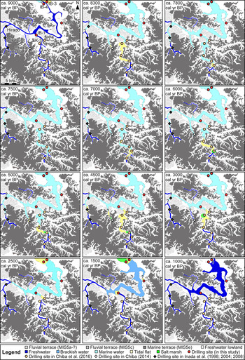
We reconstructed the palaeogeography in the Lake Inba area using the diatomaceous and dating results of cores IB-1, -3, and -4 and NR-2. The lake outlet area was occupied by a freshwater environment from 18,000 to 9000 cal yr BP. In 9000 cal yr BP, seawater inundated the Lake Inba outlet area (IB-3 and -4), and until 8300 cal yr BP, the area from the outlet to the mouth of the Kashima River (IB-1) was an inner bay. Seawater influences in the present lake area continued until 1000 cal yr BP.
Sedimentation rates at the sites of cores IB-1, -3, -4 and NR-2 (Fig. 7) showed similar patterns. Before 10,000 cal yr BP, the sedimentation rate was 0.5–0.6 mm/yr. After seawater inundated the Lake Inba area, mainly owing to the Holocene transgression (9000–8000 cal yr BP), the sedimentation rate abruptly increased to 16.1–28.9 mm/yr at the core sites. It is a possible that a hiatus occurred around 8000 cal yr BP in NR-2 for the exceptionally low deposition rate tha was recognised. Then, from 8000–2000 cal yr BP, the sedimentation rates decreased to 0.6–2.4 mm/yr at the core sites. During the period 3000–2000 cal yr BP the sedimentation rate increased at only two of the core sites (from 1.2–3.1 mm/yr in IB-1 and from 0.6–1.2 mm/yr in NR-2). These sedimentation rate changes reflect the palaeogeographic changes that occurred in the study area.
Sedimentation curve in IB-1, 3, and 4; NR-2; SK-4 (Chiba et al., Reference Chiba, Sugihara, Matsushima, Arai and Endo2016); and Obukai (index points based on Chiba [2014]).

The sediment supply for the Tone River over the past 13,000 years has been reconstructed by means of a simulation (Kubo et al., Reference Kubo, Syvitski and Tanabe2006). Although there was no major change in the amount of suspended sediment supplied during this period, the amount of bed load sediment was 97.7–115.3 kg/s from 8–6 ka and was lower (11.8–16.5 kg/s) from 4–0 ka. The amount of bed load sediment varied with changes in the riverbed slope and reached a maximum during the Holocene high stand (Kubo et al., Reference Kubo, Syvitski and Tanabe2006; Tanabe, Reference Tanabe2019). The results of this study are not inconsistent with those of these previous studies.
Reconstruction of palaeoshoreline changes in the Lake Inba area
Next, we reconstructed the palaeoshoreline in the Lake Inba area using the results from cores IB-1, -3, and -4 and NR-2 together with results reported by Chiba et al. (Reference Chiba, Kanauchi, Kamiya and Sugihara2011, Reference Chiba, Sugihara, Matsushima, Arai and Endo2016) and Inada et al. (Reference Inada, Ohama and Shimamura1998, Reference Inada, Saito, Ohama, Kaneko, Shimamura, Shimizu and Natsuaki2004, Reference Inada, Saito, Nirei, Nishimura, Ohama, Kaneko, Kaneko, Shimamura and Shimizu2008; Fig. 8). The Lake Inba outlet area was characterised by a freshwater marsh until approximately 9000 cal yr BP. During the Holocene transgression, the palaeoshoreline, as indicated by the presence of a tidal flat environment, reached the IB-3 and -4 sites at approximately 9000 cal yr BP, but it did not reach the IB-1, SK-3, -4, and -6–8 sites until 8300 cal yr BP. The palaeoshoreline reached the NR-2 and Obukai sites at approximately 8000 cal yr BP (Chiba, Reference Chiba2014); at this time, the area between the lake outlet and the SK-7 site was characterised by a subtidal inner bay environment, which also extended to the Miyauchi site (Inada et al., Reference Inada, Saito, Nirei, Nishimura, Ohama, Kaneko, Kaneko, Shimamura and Shimizu2008). By approximately 7000 cal yr BP, the palaeoshoreline had reached the SK-9 site and Obukai was in the inner bay (Chiba, Reference Chiba2014). Regression began after 6000 cal yr BP, and the salinity began to decrease at many sites, such as at SK-9 along the upper Kashima River. The tidal flat environment that had prevailed at SK-8 changed to a salt marsh, and at SK-7 and Obukai, the inner bay changed to a tidal flat (Chiba et al., Reference Chiba, Sugihara, Matsushima, Arai and Endo2016). As sea level continued to fall during the period 5000–4500 cal yr BP, the Kashima River area was characterised by less-saline environments: a freshwater marsh prevailed at SK-8, a salt marsh at Obukai (Chiba, Reference Chiba2014), and tidal flats at SK-3 and -4 (Chiba et al., Reference Chiba, Sugihara, Matsushima, Arai and Endo2016). During this period, brackish-marine diatoms such as Diploneis smithii and Tryblionella granulata increased at the Miyauchi site (Inada et al., Reference Inada, Saito, Nirei, Nishimura, Ohama, Kaneko, Kaneko, Shimamura and Shimizu2008), suggesting that a tidal flat had formed. By 3000 cal yr BP, a freshwater environment prevailed at SK-7, Obukai, and Miyauchi and there was a salt marsh at SK-3. By 2600 cal yr BP, as sea level continued to fall, tidal flats were found at the IB-3 and -4, and NR-2 sites and a salt marsh had formed at the SK-4 site. In addition, the Daikatahanawa shell mound (Fig. 1c and d), which was composed mainly of Corbicula japonica shells, accumulated on the shore of Lake Inba near the NR-2 site during the Yayoi period (from several centuries BC to the third century AD; Chiba et al., Reference Chiba, Kanauchi, Kamiya and Sugihara2011). Corbicula japonica is a bivalve that inhabits a brackish water environment; it has difficulty surviving in a marine environment (Tanaka, Reference Tanaka1984). If Corbicula japonica occurred in Lake Inba during the Yayoi period, then the salinity of the lake at that time was lower than that typical of a marine environment. After approximately 1000 cal yr BP, a freshwater environment characterised the IB-1 and -4 sites. The timing of these changes is consistent with some historical documents (Yamaji, Reference Yamaji2004). The changes in the species composition of Jomon shell mounds in the Lake Inba area are also consistent with these palaeoshoreline changes (Yoshino, Reference Yoshino1998). These lines of evidence suggest that Lake Inba's change from a saline lagoon to a freshwater lake may have partly resulted from late Holocene sea-level changes and was not caused by the effects of the so-called Tonegawa Tosen, the artificial rerouting of the Tone River channel after AD 1594 (Inazaki et al., Reference Inazaki, Ota and Maruyama2014). These results are consistent with the study of Lake Kasumigaura (Saito et al., Reference Saito, Inouchi and Yokota1990, Reference Saito, Ikehara, Tamura, Moreno, Wallis, Kojima and Gibbons2016) and Kitaura (Fig. 1; Naya et al., Reference Naya, Tanimura, Kanai, Kumon and Amano2007); desalination had progressed long before the two downstream side lakes. The Jinsokuzu map created in AD 1886 (Fig. 1c and d) shows a reverse delta in the lake outlet. This suggests that the sediment supply of the Tone River changed as a result of its artificial rerouting (Kusuda and Nirei, Reference Kusuda and Nirei1994).
(color online) Palaeogeographic maps of Lake Inba area at at approximately 9000, 8300, 7800, 7500, 7000, 6000, 5000, 4500, 3000, 2500, 1500, and 1000 cal yr BP.

Comparison of the timings of salinity changes in Lake Inba, Lake Kasumigaura, Lake Kitaura, and the Tone River lowland
In the inland lake, the timing of the salinity change is slightly later than Lake Kasumigaura and Kitaura during the Holocene transgression period (Fig. 9). The period was approximately 10,000–9000 cal yr BP and after which the inner bay environment expanded. In Lake Kasumigaura, the sea area expanded until approximately 4000 cal yr BP (Saito et al., Reference Saito, Ikehara, Tamura, Moreno, Wallis, Kojima and Gibbons2016), but in Lake Inba it began to contract at approximately 5000 cal yr BP; the sea area also contracted from approximately 2500 to 2000 cal yr BP. At that time, a closed inner bay environment formed in Lake Kasumigaura. The desalination in Lake Inba was complete approximately 1000 yr; however, the influence of seawater remained in the downstream area and Lake Kasumigaura and Lake Kitaura (Naya et al., Reference Naya, Tanimura, Kanai, Kumon and Amano2007; Naya, Reference Naya2016; Saito et al., Reference Saito, Ikehara, Tamura, Moreno, Wallis, Kojima and Gibbons2016). These differences reflect the respective positional relationships and the extended range of the tide level.
Comparison of the timing of salinity changes in Lake Inba, Lake Kasumigaura (Saito et al., Reference Saito, Ikehara, Tamura, Moreno, Wallis, Kojima and Gibbons2016), and Lake Kitaura (Naya et al., Reference Naya, Tanimura, Kanai, Kumon and Amano2007; Naya Reference Naya2016; Ito et al., Reference Itoh, Naya, Kanai, Kumon and Amano2017).

In the lowland along the Tone River, in the eastern part of the Lake Inba area, palaeogeographical changes associated with sea-level changes at approximately 7 ka were reconstructed by Tanabe et al. (Reference Tanabe S., Nakashima R. and Mizuno2014). According to Tanabe et al. (Reference Tanabe S., Nakashima R. and Mizuno2014), a spit or barrier formed in the river mouth area (the bay mouth area of the Palaeo-Kinu Bay; Fig. 1; Kikuchi, Reference Kikuchi1969; Saito et al., Reference Saito, Inouchi and Yokota1990). The tidal current reached more inland at 5 ka. Thereafter, the range that the tidal current reached moved to the seaward side because of the sea-level fall at 3 ka. The range also moved to the seaward side at 0.5 ka. The palaeogeography of the northern part of Lake Inba is also harmonious with the palaeogeographical changes reconstructed by Tanabe et al. (Reference Tanabe S., Nakashima R. and Mizuno2014).
Residual subsidence rate in the northern Lake Inba area
Lakes Kasumigaura and Kitaura did not form via damming of sandbars in the lake inlets and outlets because of sea-level changes but as a result of tectonic subsidence, similar to Lake Bradley (Kelsey et al., Reference Kelsey, Nelson, Hemphill-Haley and Witter2005) in Oregon and Lakes Biwa (e.g., Tsutsui et al., Reference Tsutsui1990) and Mikata (e.g., Yasuda, Reference Yasuda1982) in Japan. If Lake Inba, in a more inland area, formed via similar processes to these lakes, it is important to study the palaeoenvironmental reconstruction to identify the signal of subsidence and estimate the influence of the subsidence rate. Tectonic subsidence has been identified by the recognition of an abrupt increase in the sedimentation rate (Tanabe et al., Reference Tanabe, Tateishi and Shibata2009) or by lowering the levels of reconstructing points or a curves comparison between the level of sea-level index points or the reconstructing curve and the calculated or simulated sea-level curve or fitted global sea-level curve (Tanigawa et al., Reference Tanigawa, Hyodo and Sato2013; Okuno et al., Reference Okuno, Nakada, Ishii and Miura2014). The palaeosea-level change during the past 8500 yr in the northern part of Lake Inba area was reconstructed by Chiba et al. (Reference Chiba, Sugihara, Matsushima, Arai and Endo2016). According to their work, the sea level reached −9.0 m elevation in 8550–8410 cal yr BP, and then reached the Holocene high stand of + 2.8 m in 6500–6400 cal yr BP. After that, the sea level started to decrease toward the present. However, the palaeo-sea-level before 8500 cal yr BP was not revealed. We added new sea-level index points into the sea-level curve (Chiba et al., Reference Chiba, Sugihara, Matsushima, Arai and Endo2016), and revised it (Fig. 10). The possibility that an increase in the sedimentation rate and a sea-level rise in this study area is a result of subsidence centres around the IB-3 site.
(color online) (a) Relationship of relative sea-level changes among the southern part of Lake Inba area and Obukai and Kashima River areas (southern part of Lake Inba area; Chiba et al., Reference Chiba, Sugihara, Matsushima, Arai and Endo2016). (b) Relationship of relative sea-level changes among this study data, corrected values (modified from Chiba et al. [Reference Chiba, Sugihara, Matsushima, Arai and Endo2016]), the modelled sea-level curve (Okuno et al., Reference Okuno, Nakada, Ishii and Miura2014), and the sea-level curve in the Tokyo lowland (Endo et al., Reference Endo, Kosugi, Matsushita, Miyaji, Hishida and Takano1989; Tanabe, Reference Tanabe2019).

Okuno et al. (Reference Okuno, Nakada, Ishii and Miura2014) examined the tectonic crustal movements along the Japanese coastlines on three timescales (~50, ~6000, and ~125,000 yr) using several sets of sea-level observations and model predictions based on glacio-hydro isostatic adjustment processes and recent melting of mountain glaciers and the Antarctic and Greenland ice sheets. The sea-level observations applied to infer the rates of crustal movement for ~50, ~6000, and ~125,000 yr are tide gauge records at 34 sites, Holocene RSL changes at 43 sites, and the altitudes of marine terraces formed during the Last Interglacial phase (Koike and Machida, Reference Koike and Machida2001), respectively. Okuno et al. (Reference Okuno, Nakada, Ishii and Miura2014) calculated a relative sea-level curve based on geophysical modelling including glacio-hydro isostatic adjustment along the Japan coast. The mean sea level in Tokyo at 9 ka was concluded to have been −10.7 m by Okuno et al. (Reference Okuno, Nakada, Ishii and Miura2014); however, in this study, the sea level is inferred to have been -36.3 m during this period. Tanabe et al. (Reference Tanabe, Nakanishi, Ishihara and Nakashima2015) added new sea-level index points to the sea-level curve of Endo et al. (Reference Endo, Kosugi, Matsushita, Miyaji, Hishida and Takano1989) for the Tokyo and Nakagawa lowlands and obtained additional details of the changes during the sea-level rise, confirming the work of Ishihara et al. (Reference Ishihara, Toshihiko Sugai and Hachinohe2012). Tanabe (Reference Tanabe2019) further developed this research (Tanabe et al., Reference Tanabe, Nakanishi, Ishihara and Nakashima2015; Tanabe and Nakashima, Reference Tanabe and Nakashima2016) and drew a new sea-level curve. Based on the index points of Tanabe et al. (Reference Tanabe, Nakanishi, Ishihara and Nakashima2015) and Tanabe (Reference Tanabe2019), the mean sea level at 9 ka was -16.0 m.
The mean subsidence rate was calculated from the amount of subsidence divided by the time over which that subsidence occurred; this information was obtained from the elevations and ages of each sample. We adopted E 1 = −10.7 m (Okuno et al., Reference Okuno, Nakada, Ishii and Miura2014), E 2 = −36.3 m, and T = 9000 yr, which yielded:
 $$ {\lpar {-10.7 - \lpar {-36.3} \rpar } \rpar \over 9000} {\risingdotseq} \, 2.8 \ {\rm mm}/{\rm yr}$$
As the index point set by Chiba et al. (Reference Chiba, Sugihara, Matsushima, Arai and Endo2016) includes an error of at least ± 3.3 m, the actual value may have been less than 2.8 mm/yr. However, even if this error is considered, it is certain that subsidence had occurred. Similar calculations revealed that the northern part of the Lake Inba area subsided at a rate of 2.3 mm/yr relative to the Tokyo and Nakagawa lowlands. In addition, the timing of sea-level rise slightly differs from that in the Kashima River area (Chiba et al., Reference Chiba, Sugihara, Matsushima, Arai and Endo2016), which was 8500–7000 cal yr BP. This difference may reflect the difference in crustal movement patterns between the northern downstream (subsiding) and the southern upstream (uplifted) parts of the Lake Inba area (Fig. 1).
The minute influence of the subsidence was also recognised at the IB-4 site and decreased toward the south part of the Lake Inba area reviewing the cross section and isochrones (Fig. 2 and 10). On the other hand, the reduction of the scale of the water body was a result of the regression after Holocene transgression. This reconstructed palaeo environmental change is consistent with what is written in historical literature (Oya, Reference Oya1969; Yamaji, Reference Yamaji2004). If the poor drainage in this area and associated long-term bay formation during the late Holocene was the effect of subsidence as shown in this study, this does not contradict these historical records; however, the timing of the subsidence event is unknown. Namely, one possible reason that Palaeo-Kinu Bay (or Sea of Katori) was a long narrow lake until the Medieval period is subsidence. Additionally, formation of the reverse delta shown in the Jinsokuzu map developed in AD 1886 (Fig. 1c and d) possibly reflected the sediment supply resulting from subsidence. Because the influence of sediment compaction was not considered, it is possible that the estimated subsidence rate is a slight overestimation. However, subsidence in the northern part of the Lake Inba area is not inconsistent with the Quaternary tectonics and active geological structures estimated by Kaizuka (Reference Kaizuka1987).
CONCLUSION
To reconstruct the palaeogeographic and lake environmental changes resulting from the Holocene transgression and residual subsidence in the eastern Kanto Plain of central Japan, we analysed four drill cores obtained from northern part of the Lake Inba area and reviewed other core data from the southern part of the area. The palaeogeographic history resulting from sea-level changes since the Late Pleistocene was reconstructed. We determined that seawater inundation into the Lake Inba area during the Holocene transgression occurred approximately 9000 yr and the environment in Lake Inba changed from brackish to freshwater no later than 1000 yr. We also recognised the occurrence of residual subsidence during the Holocene (at a rate of 2.8 mm/yr) by comparing the model data with our palaeosea-level change data. Thus, comparison of palaeosea-level reconstructions based on modelling and the diatom fossil record is effective in interpreting long-term subsidence during the Holocene.
ACKNOWLEDGMENTS
We thank Mr. Tokuo Fujimori to accommodate in core sampling. We also thank Dr. Jun'ichi Okuno for referring to the model data in Kanto. We also thank Dr. Toshihiko Sugai, Dr. Susumu Tanabe, Dr. Arata Momohara, Dr. Shigehiro Fujino, Dr. Takahiro Shiina, and Dr. Naomitsu Yamaji for valuable discussions to improve this study. We are very grateful to Dr. Kazuo Masubuchi, Dr. Taiji Kurozumi, Dr. Kunio Yoshida, Mr. Takeji Toizumi, Mr. Kensuke Tsurumaki, and Mr. Tatsuaki Hara for helping with the sampling. And we also thank Dr. Takato Takemura, Dr. Yuriko Nakao, Dr. Akira Ono, and Mr. Taro Kannari for help and use of measuring instruments. We would like to acknowledge Dr. Taisuke Ohtsuka, Dr. Itsuki Suto, and Dr. Tsuyoshi Watanabe for discussions about diatoms. This work was supported, in part, by the Academic Frontier Project for private universities and the Program to Disseminate Tenure Tracking System, MEXT, Japan.
SUPPLEMENTARY MATERIAL
The supplementary material for this article can be found at https://doi.org/10.1017/qua.2019.69