

The number of known structures in the British Mesolithic has significantly increased during the last decade. This has enabled new interpretations of settlement patterns, some of which challenge conventional views of this period by promoting notions of hunter-gatherer sedentism. Nevertheless, the corpus of such structures remains limited and the interpretation of archaeological features remains challenging. In this contribution we report on a cluster of features from the Mesolithic site of Criet Dubh, Isle of Mull, and compare them to previously reported evidence in Britain to identify what type of structure they might represent. To do so, we initially follow Waddington and Bonsall’s (Reference Waddington and Bonsall2016, 267) identification of a suite of British Mesolithic structures as ‘pit-houses’ and contrast these with what appear to be less substantial structures, referring to the latter as ‘shelters’. We ask whether the inferred Criet Dubh structure supports or challenges this two-fold division. We then consider the radiocarbon dates from Criet Dubh and those Mesolithic structures categorised as pit-houses, contrasting two methods of analysis: those based on occupation spans as derived from Bayesian analyses and those based on activity events as derived from the extent of statistical consistency between radiocarbon dates. We note how these imply different tempos of occupation for structures and different interpretations for Mesolithic settlement patterns.
HUNTER-GATHERER STRUCTURES & SETTLEMENT PATTERNS
Lewis Binford (Reference Binford1990) argued that hunter-gatherer settlements are rarely without some form of artificial shelter. Fretheim (Reference Fretheim2017), reviewing a range of ethnographic studies as part of a comprehensive study of Mesolithic dwellings in Norway, agreed and noted their considerable diversity, ranging from insubstantial huts to pit-houses and from stand-alone structures to extensive settlements. The size, internal organisation, form, and number of structures can indicate past settlement patterns, group size, and social organisation, with a general correlation between the extent of labour investment and the degree of residential mobility (Binford Reference Binford1990; Kelly Reference Kelly1995; Fretheim et al. Reference Fretheim, Piana, Bjerck and Zangrando2016; Reference Fretheim, Bjerck, Breivik and Zangrando2018; Fretheim Reference Fretheim2017). Nevertheless, the relationships between structures and behaviour are not straightforward: even the most substantial dwelling might be used on an intermittent or seasonal basis. Moreover, before addressing questions of settlement pattern, archaeologists face the challenge of inferring what type of structure might have once been present from its residual material traces, such as stake-holes, post-holes, hearths, and discrete distributions of occupation debris.
MESOLITHIC STRUCTURES IN BRITAIN
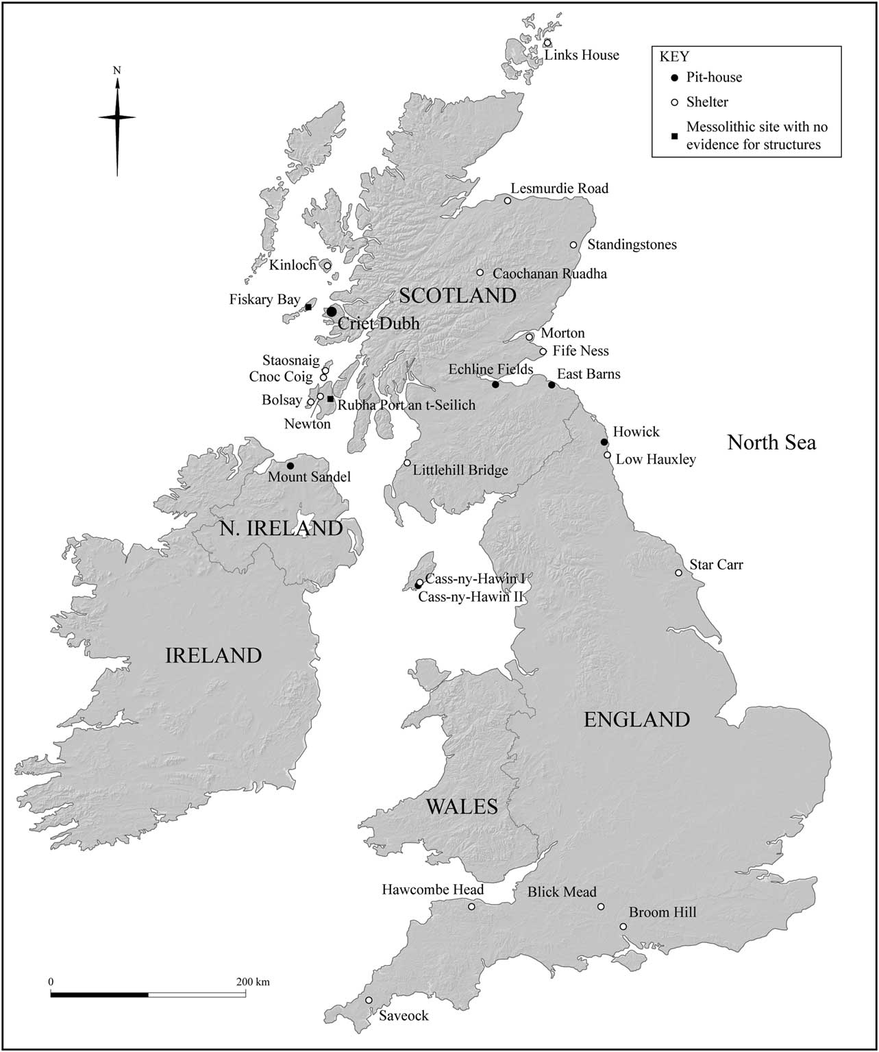
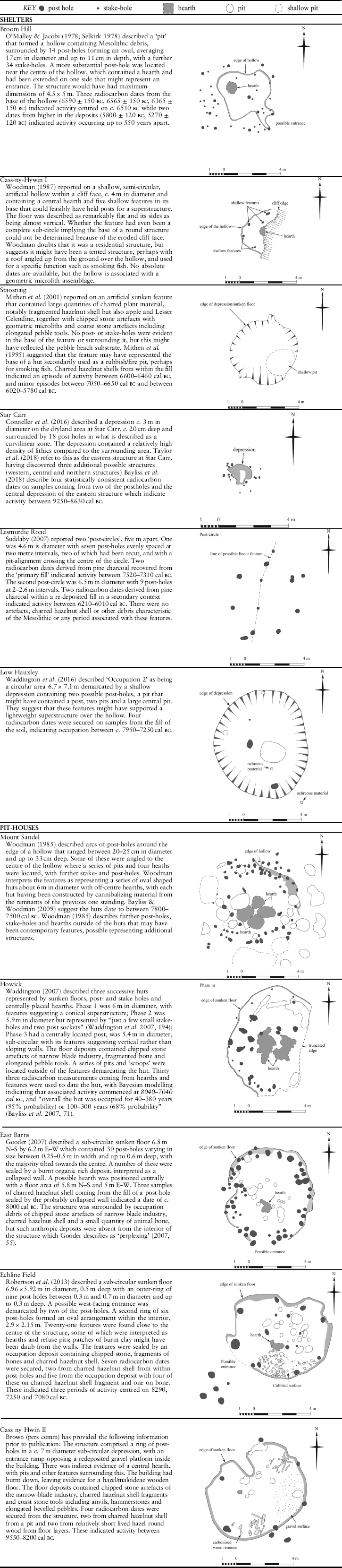
During the 1970s traces of structures were excavated at two Mesolithic sites in Britain: Mount Sandel, Northern Ireland (Woodman Reference Woodman1985) and Broom Hill, Hampshire (Selkirk Reference Selkirk1978; O’Malley & Jacobi Reference O’Malley and Jacobi1978). Both provide a suite of stake-holes, post-holes, and pits in sub-circular arrangements surrounding floor deposits, suggesting substantial structures (Table 1). That at Mount Sandel has since been categorised as a ‘pit-house’ (Waddington & Bonsall Reference Waddington and Bonsall2016, 216), while the type of structure represented by the features at Broom Hill remains unclear (Gooder Reference Gooder2007; Bayliss & Woodman Reference Bayliss and Woodman2009); we suspect it was less substantial than that at Mount Sandel and refer to Broom Hill as a ‘shelter’. Further structures have since been discovered, some appearing less substantial than those at Broom Hill and Mount Sandel and others providing further examples of the proposed ‘pit-house’ category (Fig. 1; Table 1).
Location of Mesolithic sites referred to in text

A SAMPLE OF SHELTERS AND PIT-HOUSES FROM THE BRITISH MESOLITHIC

In addition to pit-houses and shelters, two further categories of structure have been discovered. Wooden platforms and possible trackways are known from Star Carr, despite the platform originally proposed by Clark (Reference Clark1954) being an accumulation of debris rather than a deliberate construction (Mellars et al. Reference Mellars, Schadla-Hall, Lane and Taylor1998; Bamforth et al. Reference Bamforth, Taylor, Taylor, Robson, Radini and Milner2018). These have been comprehensively discussed by Bamforth et al. and will receive no further consideration. Also excluded is the evidence for probable monumental structures, notably the Mesolithic pit alignments at Warren Field, Aberdeenshire (Gaffney et al. Reference Gaffney2013) and Stonehenge (Cleal et al. Reference Cleal, Walker and Montague1995, 43–56). Both appear to have been for substantial posts. While such wooden platforms and pit alignments are evidently crucial to a full understanding of the Mesolithic, our study will be restricted to the more extensive evidence for shelters and pit-houses.
Shelters
The term ‘shelters’ has been adopted to avoid implying that such structures were necessarily for human occupation; this category encompasses racks, storage contraptions, supports for cooking devices, windbreaks, tents, huts, and composite structures (a combination of portable and stationary elements; Cribb Reference Cribb1991). These might involve minimal alterations or additions to natural features such as rock overhangs, boulders, or trees, with the boundary between the artificial and the natural being problematic (Ingold Reference Ingold2000). The remains of probable shelters are now known from numerous Mesolithic sites, with a sample illustrated in Table 1: Broom Hill (Selkirk Reference Selkirk1978; O’Malley & Jacobi Reference O’Malley and Jacobi1978); Cass-ny-Hawin I, Isle of Man (Woodman Reference Woodman1987), Staosniag, Isle of Colonsay (Mithen et al. Reference Mithen, Finlay, Carruthers, Carter and Ashmore2001), Lesmurdie Road, Elgin, Moray (Suddaby Reference Suddaby2007), Star Carr, North Yorkshire (Conneller et al. Reference Conneller, Milner, Taylor and Taylor2012, now referred to as the ‘eastern structure’, Taylor et al. Reference Taylor, Milner and Conneller2018, 63–5), and Low Hauxley, Occupation 2, Northumberland (Waddington & Bonsall Reference Waddington and Bonsall2016).
The excavators are appropriately cautious when making their interpretations of the features at these sites: a ‘light windbreak’ or a hollow sheltered by an angled roof at Cass-ny-Hawin I (1987, 18); a structure that was ‘a place of intense activity’ at Star Carr (Conneller et al. Reference Conneller, Milner, Taylor and Taylor2012, 1012); ‘a light timber frame with tent or other lightweight covering … of impermanent construction’ at Low Hauxley (Waddington & Bonsall Reference Waddington and Bonsall2016, 267), and no more than ‘post-circles’ at Elgin (Suddaby Reference Suddaby2007).
Additional sites with features and artefact distributions implying shelters are found throughout Britain. Those in Scotland include: arcs of stake-holes from Cnoc Coig (Isle of Oronsay; Mellars Reference Mellars1987); a sunken sub-rectangular area at Newton (Isle of Islay; McCullagh Reference McCullagh1989); oval scoops from Littlehill Bridge (Ayrshire; MacGregor et al. Reference MacGregor, Donnelly, Miller, Ramsay and Alldrit2010); stake-holes, post-holes, and pits from Morton (Fife; Coles Reference Coles1971), Kinloch (Isle of Rum; Wickham-Jones Reference Wickham-Jones1990), Fife Ness (Fife; Wickham-Jones & Dalland Reference Wickham-Jones and Dalland1998), and Bolsay (Isle of Islay; Mithen et al. Reference Mithen, Lake and Finlay2000); and constrained artefact distributions from Caochanan Ruadha (southern Cairngorms; Warren et al. Reference Warren, Fraser, Clarke, Driscoll, Mitchell, Noble, Paterson, Schulting, Tipping, Verbaas, Wilson and Wickham-Jones2018). A cluster of stake- and post-holes, scoops, pits, and shallow hollows interpreted as several 2–3 m diameter Mesolithic structures and a windbreak have recently been excavated at Links House, Orkney (Lee & Woodward in prep.). At Standingstones, 13 km to the north of the River Dee, an arc of eight pits enclosing an area of 3 m diameter containing a central hollow(hearth), has been interpreted as the remains of a Mesolithic structure within a ‘short-lived camp’ (Dingwall, pers. comm.).
Evidence for Mesolithic shelters from England include a green clay floor surrounded by stake-holes at Savelock (Cornwall; Wood Reference Wood2007); post-holes and a clay floor from Hawkcombe Head (Somerset; Gardiner Reference Gardiner2007); a ‘gully defined structure’ designated as Occupation 1 at Low Hauxley (Northumberland; Waddington & Bonsall Reference Waddington and Bonsall2016); and a modified tree-throw from Blick Mead in the vicinity of Stonehenge that might have been used as a shelter (Jacques et al. Reference Jacques, Lyons and Phillips2017). In addition to the eastern structure from Star Carr, illustrated in Table 1, three further clusters of shallow post-holes have been identified, referred to as the western, central, and northern structures (Taylor et al. Reference Taylor, Milner and Conneller2018). The central structure is the most substantial but is still relatively ephemeral when compared to the pit-houses, with a shallow hollow, c. 3.0×2.5 m, surrounded by post-holes. The northern structure consists of two arcs of post-holes and the western structure is a cluster of post-holes that might derive from a hut, a raised storage area, or a drying rack (ibid., 59). In addition to these putative structures, there are further isolated post-holes and pits at Star Carr, some or all of which might relate to past shelters. At Mount Sandel, Northern Ireland, an arc of stake-holes and gullies to the north of the main cluster of post-holes, pits, and hearths is likely to derive from a light shelter, which might come from a later period of activity at the site (Woodman Reference Woodman1985).
Quite what types of shelters such features from Mesolithic sites represent, if any, remain unclear in all cases. There are numerous methodological problems with their interpretation, which are shared with the pit-houses described below. These include:
∙ Contemporaneity: the difficulty of being confident about which features derive from the same structure and whether the debris contained within a floor represents the primary or a secondary use of the structure;
∙ Preservation: features such as stake-holes and post-holes might be truncated or removed entirely by later human activity, natural erosion, or soil development such as podsolisation. This constrains assessing their number, dimensions, and depth, and hence the scale of the structure that might have been supported by the surviving evidence;
∙ Equifinality: substantial structures might leave no archaeological traces or those identical to light shelters. Tents, for instance, might be either archaeologically invisible or leave highly ambiguous features while providing substantially larger and more robust shelters than small huts that leave an impressive pattern of stake- and post-holes.
Absolute dating is also problematic partly because of the limited number of radiocarbon determinations available from the sites that have ephemeral deposits. Cass-ny-Hawin I has no directly associated radiocarbon dates, and there are just two from each post-hole circle at Elgin (Table 1). The eight radiocarbon dates from the fill of the main feature (F24) at Staosnaig indicate predominant activity between c. 6800 and 5880 cal BC (with earlier and later episodes) but these might derive from a secondary use of the structure (Mithen et al. Reference Mithen, Finlay, Carruthers, Carter and Ashmore2001). That might also be the case for Occupation 2 at Low Hauxley that has four radiocarbon dates on samples from within its fill suggesting activity c. 7990–7610 cal BC (Hamilton Reference Hamilton2016). Conversely, the dating of the post-holes at Lesmurdie Road is problematic because the charcoal contained within their fills might have been redeposited from earlier activity at the site unrelated to the structure represented by post-holes (Suddaby Reference Suddaby2007). The eastern and western structures at Star Carr are dated by multiple and statistically consistent radiocarbon samples from secure contexts to 9260–8625calBC, while the central structure has a dispersed range of dates suggesting that its features have a disturbed formation history (Bayliss et al. Reference Bayliss, Taylor, Ramsey, Dunbar, Kromer, Bamforth, Conneller, Elliot, Knight and Milner2018). The Standingstones structure has been dated to approximately 7000–6700 cal BC (Dingwall, pers. comm.). Despite the limited and ambiguous dating evidence from the shelters in Table 1 and the other sites referred to above, the range of dates available and/or their relative dating based on associations with both early and later Mesolithic artefacts, suggest shelters are found throughout the entire span of the Mesolithic. Indeed, we suspect that shelters were ubiquitous at Mesolithic settlements.
Pit-houses
The shelters from Mesolithic Britain have been contrasted with a number of more substantial structures, described by Waddington and Bonsall (Reference Waddington and Bonsall2016, 216) as ‘pit-houses’ as listed in Table 1: Mount Sandel (Northern Ireland; Woodman Reference Woodman1985; Bayliss & Woodman Reference Bayliss and Woodman2009); Howick (Northumberland; Waddington Reference Waddington2007), East Barns (East Lothian; Gooder Reference Gooder2007); Echline Fields (South Queensferry, West Lothian; Robertson et al. Reference Robertson, Lochrie and Timpany2013), and Cass-ny-Hawin II (Isle of Man), which remains unpublished (Brown pers. comm.).
The term ‘pit-house’ was adopted from Norwegian terminology where it is used to describe structures with sunken floors and robust timber supports (Bjerck Reference Bjerck2007; Reference Bjerck2008; Waddington & Bonsall Reference Waddington and Bonsall2016, 266; Fretheim et al. Reference Fretheim, Piana, Bjerck and Zangrando2016; Reference Fretheim, Bjerck, Breivik and Zangrando2018; Fretheim Reference Fretheim2017). Appearing in the early part of the Norwegian Middle Mesolithic (8000–7000 cal BC) pit-houses are recognised as the oldest unambiguous houses in Norway, with ‘house’ being defined as a structure designed to withstand local ambient conditions during all seasons, even if only occupied for a few weeks each year. While Britain can now boast to having potentially five pit-houses, there are several hundred at least in Norway, often found in small groups (3–4) and sometimes in larger clusters (>10), with a similar number of other types of structures (Frethiem 2017).
The term ‘pit-house’ is problematic on various grounds, especially for the British examples. The word ‘house’ implies a range of domestic activities including sleeping, cooking, easting, socialising, and child-care, whereas some or all of these structures might have been for specialised functions, such as smoking fish or ritual activities. Equally, they might have changed their functions over time, either temporarily within the course of an annual settlement pattern, as described by Binford (Reference Binford1982) for the Nunamiut, or more permanently over a longer period of time: on some occasions used for domestic activities and at others for hunting or fishing camps.
In light of these caveats, the term ‘pit-house’ is most appropriately used as a descriptive rather than an interpretative label. In this regard it captures significant similarities between the Mount Sandel, Howick, East Barns, and Echline Fields structures. These are all circular, c. 6 m in diameter with sunken floors and have a combination of post-holes, stake-holes, and hearths (Table 1); only the phase 3 structure at Howick has a central post, this also being anomalous by having a sub-rectangular form. The better preserved – Howick and Mount Sandel – suggest multiple rebuilds on the same footprint. These pit-houses appear to be stand-alone structures rather than parts of multi-pit-house settlements. This might, however, reflect the limited extent of excavation and/or preservation. Surrounding structures might have been less substantial, falling into our category of shelters that includes storage and drying racks. Such shelters might be represented by the occupation horizon around the periphery of East Barns (Gooder Reference Gooder2007), and the range of features outside of the hut/pit-house area at Mount Sandel (Woodman Reference Woodman1985), while a number of structures smaller than the pit-house have been recorded at Echline Fields (Robertson et al. Reference Robertson, Lochrie and Timpany2013).
With regard to chronology, Bayliss and Woodman (Reference Bayliss and Woodman2009, 121) note that Mount Sandel, Howick, and East Barns were all built during one short period of time between c. 8000 and 7600 calBC referring to this as a ‘curious aspect of the settlement archaeology of the British Isles’. The hut at Echline extends this period by having a date of c. 8300 calBC leading Robertson et al. (Reference Robertson, Lochrie and Timpany2013) to invoke a ‘house horizon’, while the pit-house from Cass-ny-Hawin II is similarly dated to 8200–7950 calBC (Brown pers. comm.).
Waddington et al. (Reference Waddington, Bailey, Bayliss and Milner2007, 207) suggest this limited chronological range for pit-houses derives from a ‘particular response to a specific set of historical, social, economic and environmental circumstances’ – namely sea level rise and a secondary colonisation of Britain as documented by the appearance of a Narrow Blade industry with its preponderance for geometric microliths. Waddington associates the pit-houses with the appearance of the Narrow Blade industry and a predominantly coastal exploitation pattern by a newly arriving population, viewing these as three elements of a cultural package: pit-houses, geometric microliths, and coastal adaptation (Waddington Reference Waddington2015; Waddington & Bonsall Reference Waddington and Bonsall2016). He contrasts this with a proposed terrestrial-focused lifestyle for the pre-existing Mesolithic population in Britain associated with a the Broad Blade technology, as represented at Star Carr.
CRIET DUBH, ISLE OF MULL
Discovery and excavation
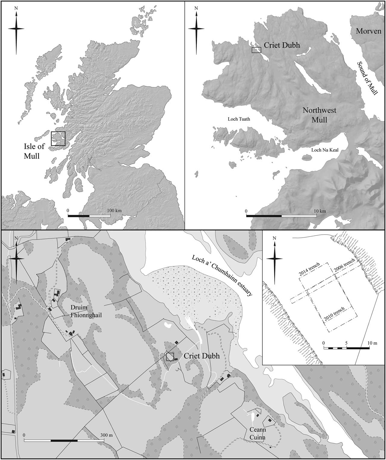
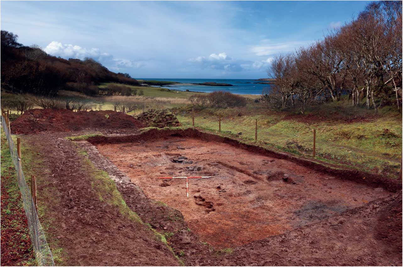
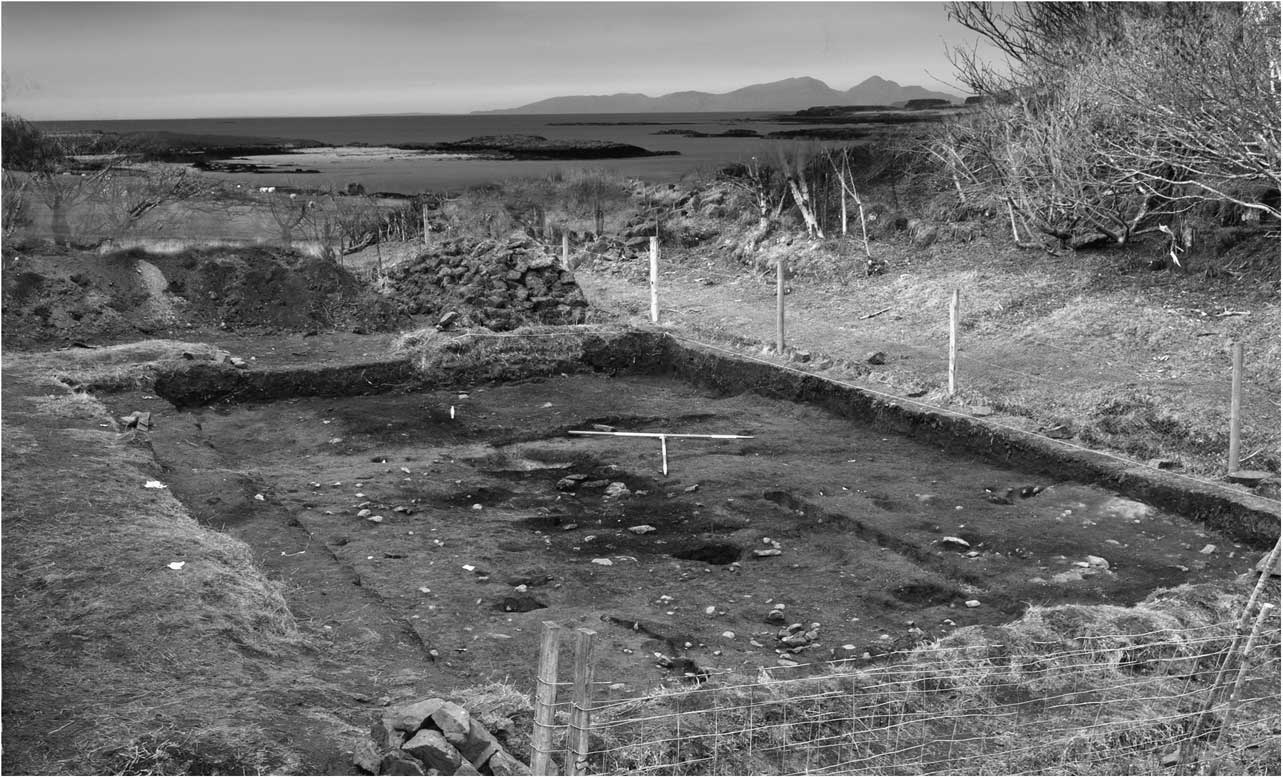
Criet Dubh is the name of a modern house situated c. 500 m from the south-west side of Loch a’ Chumhainn estuary on the Isle of Mull, western Scotland (NGR: NM40923 753118) (Figs 2 & 3), and adjacent to a small burn. The archaeological site is located to its immediate north, between two linear outcrops of rock that enclose Criet Dubh’s sheltered garden. Chipped stone was exposed in 2000 while the garden was being cultivated, and inspected by the authors in November 2005. The artefacts were typical of the Mesolithic Narrow Blade industry as found elsewhere in western Scotland (Mithen Reference Mithen2000; Saville Reference Saville2004), mixed with some later material including a barbed and tanged arrowhead.
Map showing the location of Criet Dubh situated within a few hundred metres of the western shore of Loch a’ Chummhain estuary in north-west Mull, western Scotland, and plan of excavation showing 2006 trial trench, 2010 test trench, and the 2014 excavation

View of Criet Dubh Mesolithic site, looking north

A 2006 trial trench exposed a heavily cultivated soil containing chipped flint, glazed pottery, and modern debris. Its removal exposed the fill of a feature 1.6 m wide that had been cut into a sterile weathered bedrock deposit. The feature (later designated as Feature 55) was sectioned to reveal several flat slabs that appeared to have been deliberately positioned and embedded within a greasy, black organic rich deposit. The full extent of the feature was not exposed and so whether it was the terminus of a linear ditch-like feature, a pit, or a hearth, remained unclear. A fragment of charred hazelnut shell from its fill returned a date of 7830±80 BP (Beta-221402; Table 2).
THE INTERPRETATION OF FEATURES FROM CRIET DUBH

A 2010 exploratory excavation (7×7 m) exposed an amorphous spread of greasy, organic and artefact rich black sediment (later designated as Feature 1; Fig. 4), from which a charred twig (of indeterminate species) provided a date of 7900±40 BP (Beta-288420). A number of discrete features were also exposed, the majority of which remained unexcavated (Mithen & Wicks Reference Mithen and Wicks2011; Wicks & Mithen Reference Wicks and Mithen2011). One feature, later designated as Feature 83, provided a charred hazelnut shell fragment dated to 9080±40 BP (Beta-288421) (Table 2).
The ‘capping spread’ (Feature 1) that sealed the stone-lined fire-pits in the centre of the trench, looking north towards the Isles of Rum, Muck, and Eigg

In 2014 the site became at risk from further cultivation. As a consequence, the suite of features was fully excavated within a 15×7 m trench. This demonstrated that the greasy spread (Feature 1) was an amalgam of the redeposited fills from multiple underlying and surrounding features that had been heavily truncated by recent gardening activity. A second amorphous spread of redeposited fill was located at the northern end of the Trench (Feature 70), and was most likely a continuation of Feature 1 but separated by a baulk of the excavation.
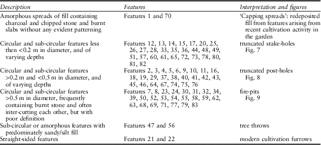
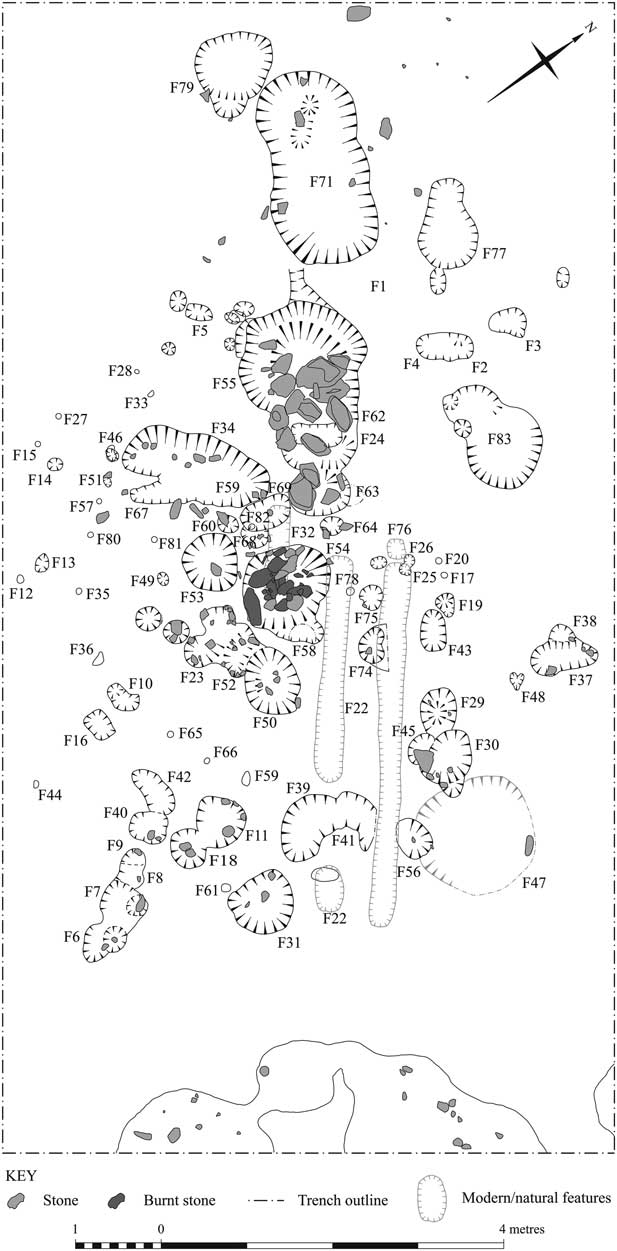
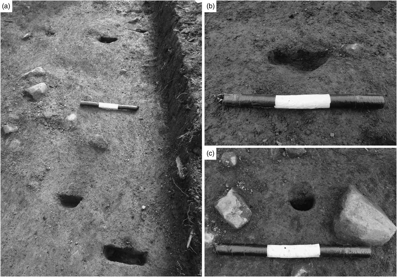
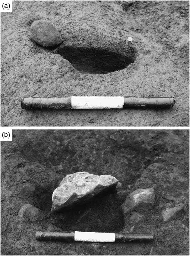
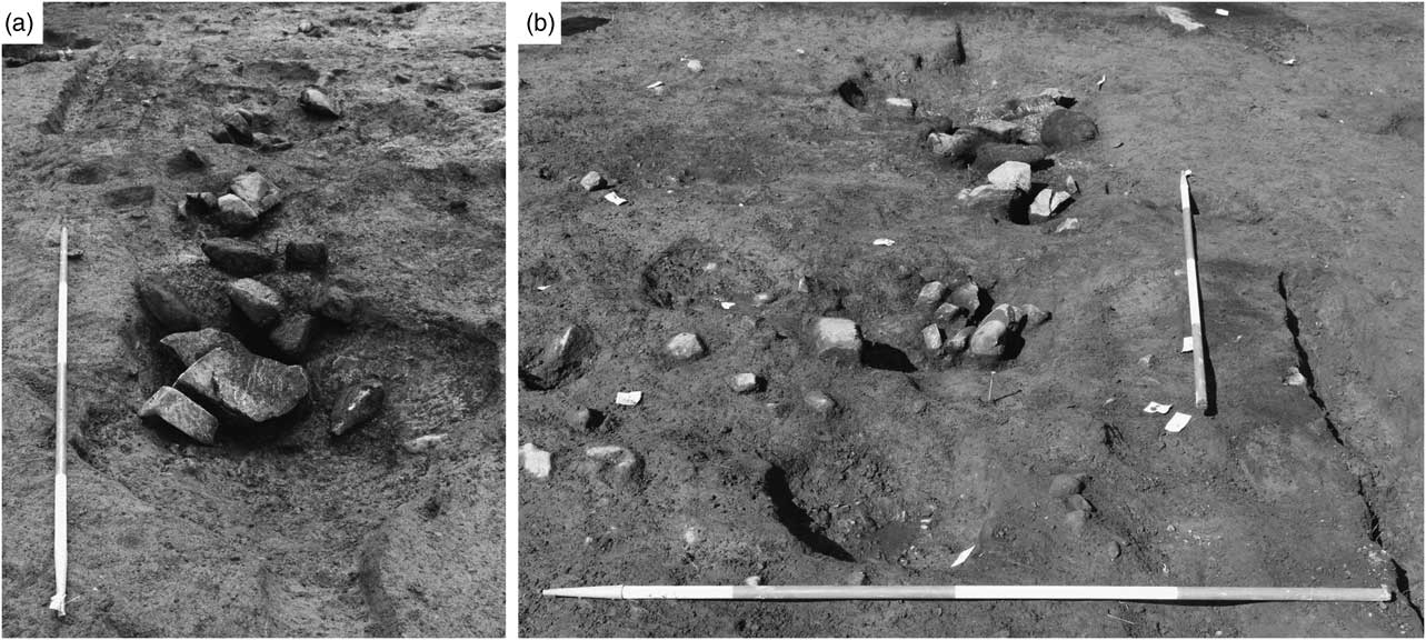
Below and around these amorphous spreads 81 features of varying character were identified (Fig. 5). The majority of these were filled with a similar organic rich, black greasy fill, often containing chipped stone artefacts and charcoal. The larger features contained stone slabs and rocks, some of which had been heavily burned and sometimes appeared to provide a lining to the feature. The majority of these larger features were in clusters with considerable but poorly defined intercutting, while the surrounding smaller features were isolated from each other. A classification system was devised according to the general shape, size and fill of the features, resulting in six broad categories with associated interpretations: capping spreads, stake-holes (Fig. 6), post-holes (Fig. 7), fire pits (Fig. 8), tree throws and modern cultivation furrows (Table 2).
Distribution of features at Criet Dubh below and around the ‘capping spreads (Features 1 & 70)

A sample of features interpreted as stake-holes: a) Features 12, 13, 14, 15; b) Features 25 & 26; c) Feature 57

A sample of features interpreted as post-holes: a) Feature 46; b) Feature 45

A sample of features interpreted as fire-pits: a) Feature 55 looking south-east; b) Feature 63, 62, 55 looking north-west

With the exception of the capping spreads (F1 and F70), a 100% sample of the fill was removed from the majority of features, generating 68 bulk samples for wet sieving through a 3 mm mesh. Sieve residues were air-dried and sorted to recover flint and quartz artefacts, wood charcoal, and charred hazelnut shell; bone was entirely absent. A 5% sample of the sediment from Features 1 and 70 (the ‘capping spreads’) was processed in an identical manner.
Associated artefacts
Anne Pirie
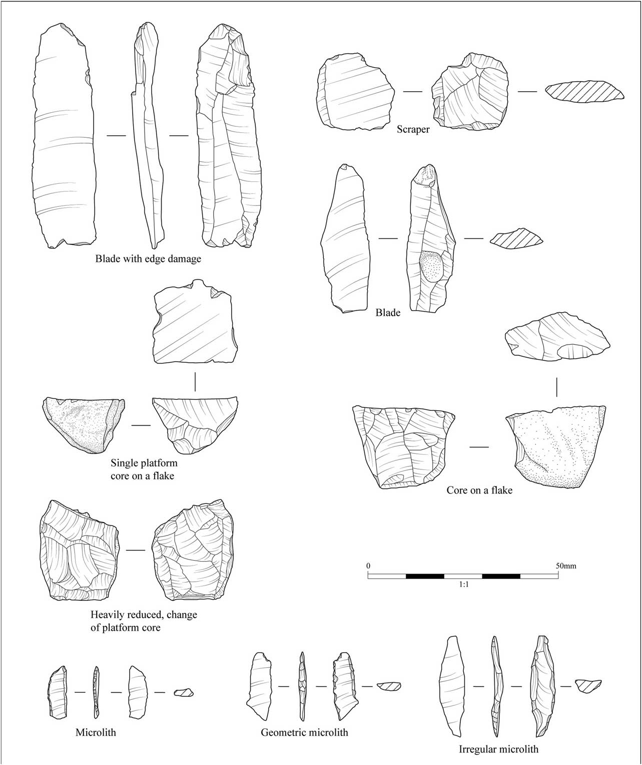
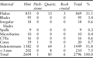
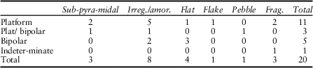
In striking contrast to other Mesolithic sites in the region, such as Staosnaig (Colonsay), Bolsay (Islay), and Rubha Port an t-Seilich (Islay) (Mithen Reference Mithen2000; Mithen et al. Reference Mithen, Wicks, Pirie, Riede, Lane, Banjerea, Cullen, Gittins and Pankhurst2015), coarse stone artefacts such as spherical hammerstones and elongated pebble tools were entirely absent from Criet Dubh. An assemblage of 2796 chipped stone artefacts, predominantly on flint, was collected during excavation in 2014 (Table 3), a sample of which is illustrated in Figure 9. Any surviving cortex suggested the use of beach pebbles as raw material. Burnt artefacts are frequent, resulting in large numbers of fragmentary indeterminate pieces (51%). The assemblage has a predominance of flakes and very few cores, most of which are notably small (Table 4; Fig. 9). Over half of the cores (55%) are platform cores and a further 15% show mixed platform and bipolar reduction; only 25% are purely bipolar with no extant signs of platform reduction.
Sample of the chipped stone artefacts from Criet Dubh

CHIPPED STONE ASSEMBLAGE RECOVERED FROM CRIET DUBH FEATURES, 2014

CORES, CRIET DUBH 2014

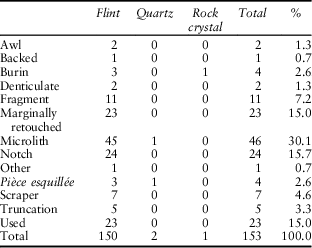
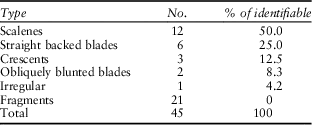
The tool assemblage (Table 5) is largely on flint (98%), and frequently on blades (41.3%). A wide range of tools is present; microliths constitute the dominant tool class (30%), with scalenes making up 50% of the identifiable forms (Table 6). Many of these have retouch on the lateral edge opposite to the backing, and a number of them have a tang-like end, often on the proximal end. There are small numbers of other tools present, made on flakes – truncations, awls, denticulates, backed flakes, pièces esquillées, and burins (often showing edge damage).
TOOL ASSEMBLAGE, CRIET DUBH 2014

MICROLITHS, CRIET DUBH 2014

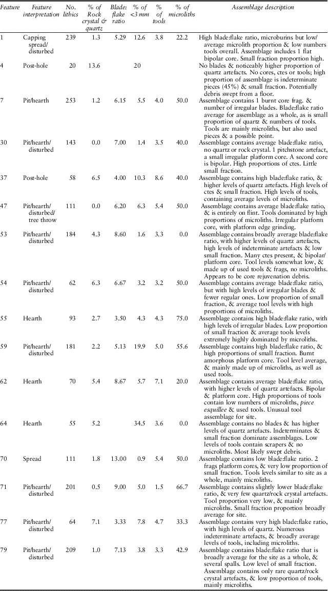
Of the 83 features recorded at the site, 15 yielded chipped stone artefacts mostly concentrated in the capping spreads (F1 & F70), the northern part of the sequence of stone-lined fire pits (the fill of Feature 55) and the fill of the intercutting pits/hearth (Features 6–8) to the south of the site. Table 7 provides a summary of the main measures of variability between these assemblages.
INTER-ASSEMBLAGE VARIABILITY OF CHIPPED STONE CRIET DUBH FEATURES, 2014

In summary, the chipped stone assemblage from Criet Dubh falls into the Narrow Blade tradition, with close similarity to Mesolithic assemblages within the region. Two aspects of the assemblage are especially notable. First, there is little sign of knapping activities at Criet Dubh, with low levels of small fraction, and few cores. Those present are small and heavily worked. Only one shows extant bladelet removals, but many could have been used for bladelet removal in earlier stages of their reduction. The small and irregular nature of both platform and bipolar cores suggests they were being used in their final stages at Criet Dubh. It is interesting that platform reduction remains dominant, even in the final, heavily used stages of these cores. A pitchstone core is also likely to have been heavily curated, as seen in its small size and irregular form.
Secondly, the Criet Dubh assemblage is made up of a series of sub-assemblage types: quartz dominated rather than flint; flake dominated rather than blade; no microliths; very few tools of any sort. No chronological patterning is evident and we suspect that the principle determinant is variation in activities across the site from which waste was deposited into features, either by primary discard, such as into the edge of fire-pits, by secondary discard, such as being swept into rubbish pits, or by post-depositional erosion.
Dating and chronology
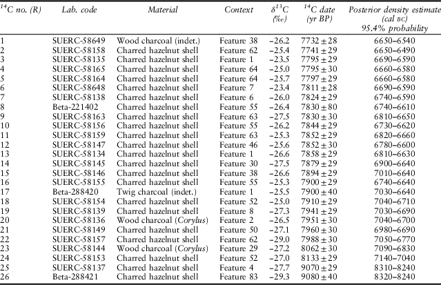
Twenty-six samples of charred plant remains were submitted to the SUERC and Beta Analytic radiocarbon laboratories for AMS dating (Table 8). Twenty-two of these were single-entity fragments of charred hazelnut shell collected in sieve residues extracted from the black organic-rich deposits containing artefacts found in-filling the multiplex of Mesolithic features. A further four samples were obtained from single fragments of burnt Corylus (SUERC-58136 & SUERC-58144) and wood charcoal (SUERC-58649, indeterminate; Beta-288420, twig wood).
RADIOCARBON DATES & POSTERIOR DENSITY ESTIMATES FOR MESOLITHIC ACTIVITY AT CRIET DUBH, ISLE OF MULL

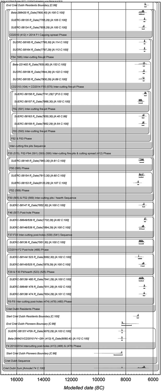
To provide a chronological framework for the start and end of Mesolithic activity at Criet Dubh we constructed a Bayesian site model (Fig. 10) using OxCal v. 4.2 radiocarbon plotting software (Bronk Ramsey Reference Bronk Ramsey2009) using the IntCal13 atmospheric curve for calibration (Reimer et al. Reference Reimer, Bard, Bayliss, Beck, Blackwell, Bronk Ramsey, Grootes, Guilderson, Haflidason, Hajdas, Hatte, Heaton, Hoffmann, Hogg, Hughen, Kaiser, Kromer, Manning, Niu, Reimer, Richards, Scott, Southon, Staff, Turney and van der Plicht2013). We acknowledge that modelled outputs are built on our current chrono-stratigraphic interpretation of the features recorded – these being subject to revision in light of new priors being added to existing Bayesian chronological frameworks. Following standard protocol for the reporting of modelled radiocarbon dates, posterior density estimates are indicated by italicised text and are given as 95% probability ranges (Fig. 10; Table 8). Using the Sum command in OxCal, we extracted a summed calibrated probability distribution from the Bayesian chronological site model to provide a prima facie indication for the degree of continuity in Mesolithic occupation at the site (Fig. 10).
Bayesian chronological plot showing posterior density estimates for Mesolithic activity at Criet Dubh, with a summed probability distribution at the base of the plot indicating two separate phases of occupation

The validity of the model can be measured by its agreement index value ([Amodel]), which in this study falls above the acceptable threshold of >60% with convergences [C] in excess of 95% (Bronk Ramsey Reference Bronk Ramsey2011). The range of radiocarbon determinations indicated two main phases of Mesolithic occupation. The first falls between c. 8320 and 8230 calBC (Table 8) and relates to just two of the 26 dates, these coming from two adjacent features (Feature 4 & 83) from which no artefacts were recovered. The second phase of Mesolithic activity at Criet Dubh is centred on the multi-phase sequence of stone-lined fire pits located within the interior of the purported hut dating to c. 7100–6580 calBC (Table 8).
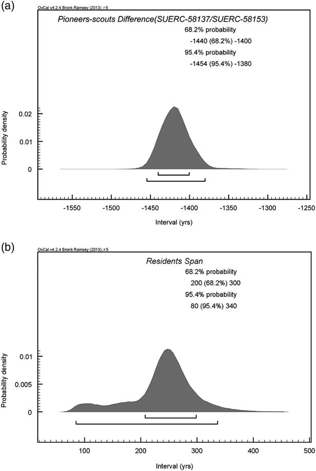
Difference and Span commands were used to extract information concerning the period of time between phases of occupation and their duration. These suggested 1454–1380 years of separation (at 95.4% confidence) and a duration of 80–340 years for the second phase of activity (at 95.4% confidence) (Fig. 11).
(a) OxCal plot showing the likely separation in time between the two phases of occupation at Criet Dubh; (b) Oxcal plot showing the likely span of the second phase of occupation at Criet Dubh

A shelter, a pit-house, or something else?
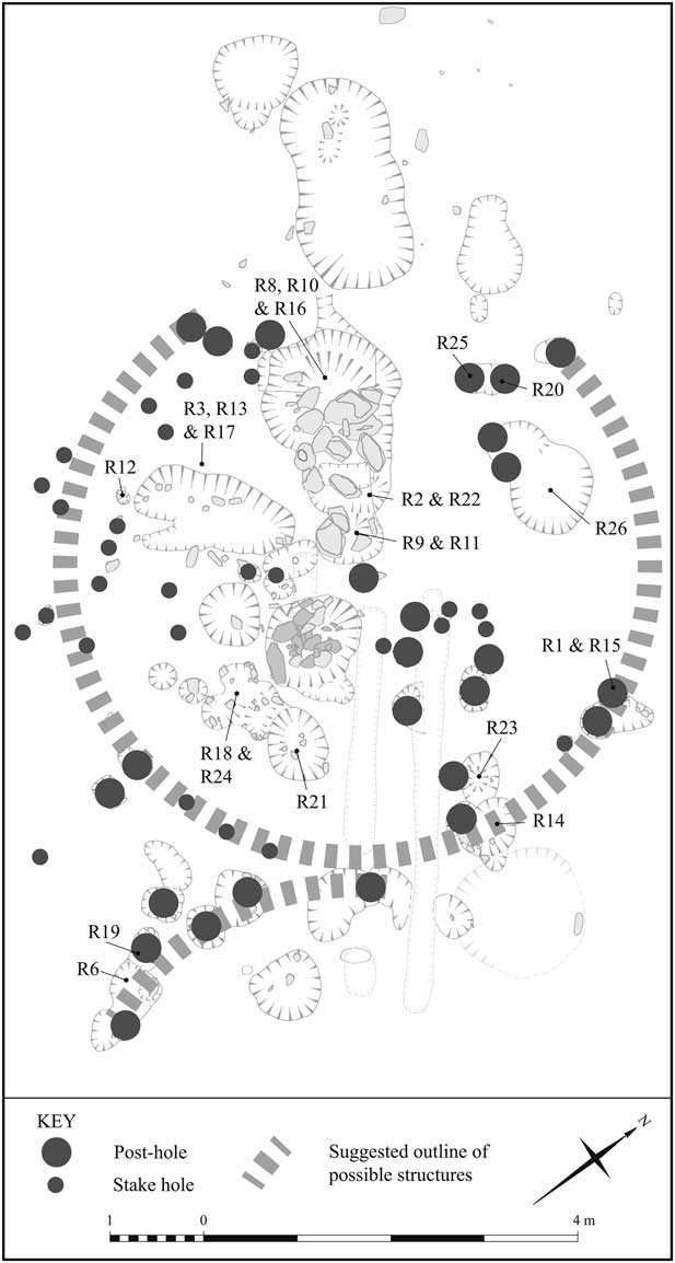
Does Criet Dubh fit into the ‘shelter’ or ‘pit-house’ categories, or neither? Figure 12 draws on the interpretations of features as stake-holes, post-holes, and fire-pits proposed in Table 2. We recognise that these interpretations are problematic, because of the issues noted above: contemporaneity, preservation, and equifinality; we also note that the low rocky crags between which the features are located might reasonably be considered as part of the structure. Nevertheless, the number and distribution of features has similarities to those from Mount Sandel, Howick, and East Barns, and indicate a more substantial structure – or structures – than the shelters in Table 1, with the possible exception of Broom Hill. Notable similarities to pit-houses include: the circular arrangement of features; the overall dimension of that arrangement (c. 6 m); the mix of post-holes and stake-holes; the absence of a central post-hole (which is otherwise only known at Howick Phase 3 structure); and the location of hearths within the arrangement.
Schematic distribution of the stake-holes, post-holes, and fire-pits at Criet Dubh, indicating where samples were taken for radiocarbon dating and interpreted as remains of a hut

Conversely, Criet Dubh appears to lack some key features of the pit-houses. It seems unlikely that truncation of the deposits can account for the absence of a sunken floor and of post-holes for timbers of an equivalent size to those inferred at Mount Sandel, Howick, East Barns, and Echline Fields – although the shelter provided by the adjacent rocky outcrops might have made such timbers unnecessary. Pebbles tools are notably absent at Criet Dubh while prominent at Howick and East Barnes. With regard to dating, the initial phase of activity fits with that of the pit-houses (8300–7600 calBC), but this is only represented by two dates coming from adjacent features at Criet Dubh, and has no directly associated chipped stone artefacts. The majority of dates relate to a second phase of activity, c. 7100–6560 calBC, during which the structure is likely to have been (re?)constructed and in use.
In summary, Criet Dubh does not comfortably fit into either the shelter or the pit-house categories of Mesolithic structures. The most reasonable interpretation is that the features represent a hut with an entrance at the north-east, hearths just within the interior, and internal features, possibly racks. As such, in terms of its size and construction, Criet Dubh, appears to sit between shelters and pit-houses, as is the case for Broom Hill. This serves to emphasise the continuous range of variability in Mesolithic structures in Britain, as seen within and between the shelter and pit-house categories, while leaving the pit-houses as a distinct and chronologically limited category of structure. We suspect that the absence of coarse stone artefacts at Criet Dubh, the limited evidence for flint knapping, and its already sheltered location between two linear outcrops of rock, suggest the structure was used for a specialised economic activity, perhaps smoking fish and meat, rather than – or in addition to – its use for domestic activities.
OCCUPATION SPANS OR ACTIVITY EVENTS?
Interpretations based on occupation spans
The interpretation of pit-houses has been influenced by the perceived labour and time costs of their construction, as explored through experimental archaeology (Waddington Reference Waddington2007). Interpretation has also drawn on the use of multiple radiocarbon determinations and the techniques of Bayesian analysis. On the basis of a Bayesian analysis of the 33 radiocarbon dates from Howick, Waddington et al. (Reference Waddington, Bailey, Bayliss and Milner2007, 196–8) argued that a hut stood at the site for 100–300 years, describing it as a ‘a permanent structure’ and discussed various scenarios for its use, ranging from seasonal to fully sedentary occupation, concluding that it was a structure ‘that was used for much of each year’. Gooder (Reference Gooder2007, 57) similarly interpreted the ‘robust and time-consuming construction’ at East Barns as representing a ‘planned, long duration of occupation’, that was described as ‘near permanent’ and an ‘economic strategy of sedentism’. Bayliss and Woodman (Reference Bayliss and Woodman2009, 118) reached similar conclusions from Mount Sandel, suggesting its use persisted over 80–290 years, representing ‘one or two generations’, while Robertson et al. (Reference Robertson, Lochrie and Timpany2013, 57) proposed that Echline and the other pit-houses indicates ‘a degree of sedentism or extended residence not traditionally identified with sites of this period’ (i.e., the Mesolithic).
These are all reasonable interpretations when based on the occupation spans as derived from Bayesian analysis, the construction costs of the pit-houses as inferred from the features present, and/or the presence of intercutting features suggesting multiple occupations. The evidence from Criet Dubh could provide a similar interpretation: the Phase 2 occupation has a span of 80–340 years (Fig. 11) during which there appears to have been a substantial structure with repeated recutting of interior fire-pits.
While reasonable, we are cautious about such interpretations invoking partial or full sedentism. When such behaviour is attested in the archaeological record, such as for the Early Natufian of south-west Asia, the Ertebølle of southern Scandinavia, the Jomon of Japan, and the north-west coast of America, there is a considerable elaboration of material culture, sites with multiple dwellings, and the creation of cemeteries (see Mithen Reference Mithen2003 for a review). Such evidence is unknown in the ‘pit-house’ phase (8300–7600 calBC) of the British Mesolithic. As such, we suggest an alternative method for the analysis of radiocarbon dates from the pit-houses and Criet Dubh, which leads to interpretations that stress mobility within a sparsely populated landscape.
Interpretations based on activity events
We will consider the radiocarbon evidence from the view of activity events (Wicks & Mithen Reference Wicks and Mithen2014) rather than span analysis. An activity event analysis simply provides a measure of the degree of statistical consistency amongst radiocarbon determinations, the premise being that a tally of groups of statistically consistent dates plus individual statistically inconsistent dates provides a proxy for the minimum number of events at the site that would be necessary to account for the radiocarbon record. The term ‘event’ is of course problematic because statistically consistent radiocarbon dates might still allow for a number of successive events occurring at any point in time bracketed within a calibrated date range, distributed either uniformly or randomly.
Acknowledging this caveat, assessing the number of activity events is the radiocarbon equivalent to assessing the MNI required to account for an assemblage of animal bones at an archaeological site. Just as it is prudent to refer to the minimum number of individuals when cataloguing a faunal assemblage, it is equally prudent to refer to the minimum number of events (MNE) required to create the assemblage of radiocarbon dates – an event being either a single moment in time or a succession of moments that cannot be distinguished between by the radiocarbon dating evidence. It could be argued that Bayesian span analysis does the opposite: it provides the maximum duration of time that the radiocarbon dates might represent, which seems equivalent to citing the maximum number of individuals that might have contributed to a faunal assemblage. The Bayesian span analysis appears inherently more suited to sites when the default assumption is of continuous occupation, such as a farming or urban settlement; when dealing with hunter-gatherers the default should be a pattern of intermittent occupation, whether seasonal, of an inter-annual, or a sporadic basis. That does not preclude the possibility of identifying sedentary behaviour, just as we might identify highly mobile behaviour in the later prehistoric and historic periods.
As with the MNI of a faunal assemblage, there might be a variety of reasons why an MNE under-estimates the true number of activity events at an archaeological site: plateaus in the calibration curve might bias the distribution of dates; disparities between the actual duration of activity and the age of related dated material; the destruction of evidence of earlier events by later activity; excavation sampling strategies; human activities that fail to leave any archaeological traces containing material that can be radiocarbon dated.
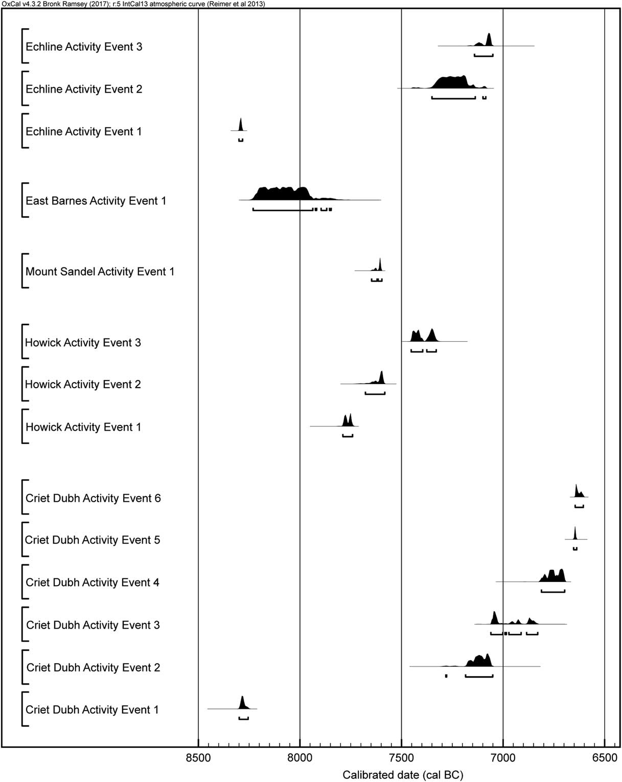
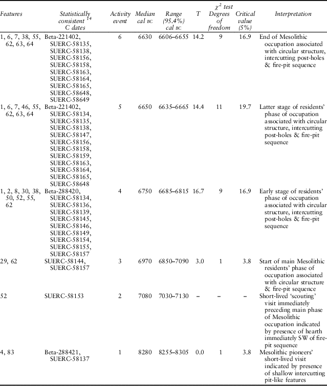
We used the Combine command in OxCal to determine statistical consistency. This indicated that the existing chronological evidence at Criet Dubh could be accounted for by six activity events. Five groups of dates were statistically consistent with some dates being members of two groups, whilst a single date (SUERC-58153) was entirely statistically inconsistent (MNE=6; Table 9; Fig. 13). Noting that an ‘event’ might be a series of successive visits that cannot be distinguished chronologically, we used the combined calibrated date ranges to provide an indication of the span of years within which an event could have occurred (at 95.4% confidence levels). The earliest activity event indicated a single occupation, or a series of visits in close succession, falling at any point within a 50 year period centered on 8280 calBC (Phase 1). Subsequent activity events occurred across a 100 year span centred on 7080 calBC, a 240 year span centred on 6970 calBC, a 130 year span centred on 6750 calBC, a 30 year span centred on 6650 calBC, and a 50 year span centred on 6630 calBC (all within Phase 2). Hence the span of 80–340 years for Phase 2 as derived from Bayesian analysis (Fig. 11), might be accounted for by no more than five separate visits to the site, with events 2 and 3 possibly separated in time by as much as 280 years, events 3 and 4 by 405 years and events 4 and 5 by 180 years. The uppermost events fall in closer succession separated in time by up to 60 years (Fig. 13).
Activity events at Criet Dubh and pit-houses in Mesolithic Britain

MESOLITHIC ACTIVITY EVENTS AT CRIET DUBH

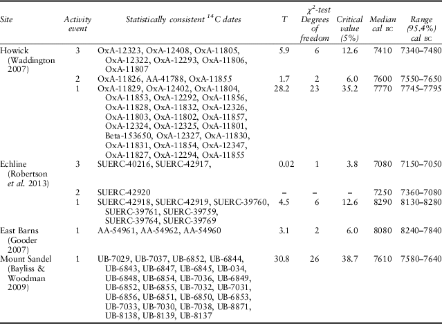
For Howick, Waddington & Wicks (Reference Waddington and Wicks2017, Table 1) calculated an MNE of three. Using the Combine command in Oxcal, the 33 radiocarbon dates, that provided an occupation span of 100–300 years, fall into no more than three statistically consistent groups indicating the occurrence of activity events within a 50 year span centred on 7770 calBC, a 100 year span centred on 7600 calBC, and a 140 year span centred on 7410 calBC (Table 10; Fig. 13). Separations in time by up to 245 years between events 1 and 2 and 310 years between events 2 and 3 conflict with the field observations of no evident hiatus in any of the archaeological deposits that could denote episodes of prolonged abandonment (Waddington Reference Waddington2007, 196). We note the word ‘evident’ and the difficulty of inferring periods of abandonment within re-used structures. A scenario of intermittent occupation at Howick matches the caution expressed by Waddington et al. (Reference Waddington, Bailey, Bayliss and Milner2007, 198) that a permanent structure does not necessarily imply permanent and continuous residency. As illustrated in Figure 13, the entire span of activity at Howick might be represented by no more than three events; alternatively there might have been 33 separate visits to the site, each represented by one of the radiocarbon dates, with these being clustered into three periods of activity separated by periods of abandonment.
ACTIVITY EVENTS AT MESOLITHIC PIT-HOUSES

Using the same OxCal Combine method, the radiocarbon dates from Echline also have an MNE of three, with events widely separated in time by as much as 1195 years after the first event, centered on 8290 calBC, and 360 years after the second event, centred on 7250 calBC (Table 10; Fig. 13). Only the first of these events relates to activity within the hut structure itself – the later events arising from deposits that sealed the post-holes (Robertson et al. Reference Robertson, Lochrie and Timpany2013). Even more striking, the 27 radiocarbon single-entity dates drawn upon by Bayliss and Woodman (Reference Bayliss and Woodman2009) in their re-analysis of the Mount Sandel hut(s)/pit-house(s) are all statistically consistent with each other giving an MNE of one: there might have been one single event at Mount Sandel that fell within a 60 year span centered on 7610 calBC, located within the Bayesian derived occupation span of 80–290 years (Table 10; Fig. 13); alternatively there might have been as many as 27 separate events (each represented by a single radiocarbon date) falling within this 60 year period. As such, the sequence of huts/pit-houses at Mount Sandel might have been built in quick succession within a time period contained within that single activity event (60 years). The three radiocarbon dates from East Barns are also statistically consistent with each other (MNE = 1), indicating the possibility of a single event centred on 8080 calBC (Table 10; Fig. 13).
Broom Hill is also interesting in this regard, although the radiocarbon dates are less helpful by having relatively large standard deviations. Nevertheless, the three dates from the base of the occupation hollow indicate one activity event at c. 6510 calBC. The two later dates from higher in the archaeological sequence represent independent events occurring c. 5800 calBC and 5270 calBC separated in time by up to a 550 year interval, with the uppermost archaeological deposits showing a period of abandonment.
Even when one recognises that a single activity event might represent a close succession of events and bears in mind how, as with MNI for a faunal assemblage, the MNE of a site might be an under-estimate, the small number of activity events for the pit-houses and their potentially wide spacing apart in time appears incongruous with interpretations of these structures being continuously used over several generations with economic strategies of partial or full sedentism. This is most notable for Howick with its large number of radiocarbon dates, suggesting that the low number of activity events is unlikely to be a consequence of sample bias from the archaeological record.
FURTHER ARCHAEOLOGICAL, ETHNOGRAPHIC & ARCHAEOLOGICAL PERSPECTIVES
Were pit-houses for winter occupation?
The low number of activity events at the pit-houses is even more striking when one considers that several Mesolithic sites lacking any evidence of structures and having fewer radiocarbon dates, have higher numbers of activity events: Rubha Port an t-Seilich (Isle of Islay) has only nine dates but six events (Mithen et al. Reference Mithen, Wicks, Pirie, Riede, Lane, Banjerea, Cullen, Gittins and Pankhurst2015) and Fiskary Bay (Isle of Coll) has only six dates but three activity events (Wicks & Mithen Reference Wicks and Mithen2017).
Both Rubha Port an t-Seilich and Fiskary are in attractive coastal locations for fishing and foraging, and with good harbours for small boats. Hence, such repeated visits are not surprising. Neither location appears to have required ‘investment in place’ as represented by the construction of a hut – although neither site has received sufficient open area excavation to absolutely discount this possibility. The estuarine and coastal settings of Mount Sandel, East Barns, Howick, and Echline are unlikely to have been significantly different from those at Rubha Port an t-Seilich and Fiskary, and hence it is unclear why such structures were constructed and then appear to have been used so infrequently.
One possible reason for constructing pit-dwellings at some locations but not at others relates to seasonality. Fretheim et al. (Reference Fretheim, Piana, Bjerck and Zangrando2016) note that pit-houses known from the ethnographic record are consistently associated with three conditions: (1) a non-tropical climate; (2) a seasonal settlement pattern with pit-house occupation in the cold season; (3) a reliance on stored food while the pit-house is inhabited. As such, the pit-houses from the British Mesolithic might relate to winter occupation in locations where stored food could be accumulated, while occupation at sites with multiple activity events but without structures, such as at Fiskary and Rubha Port an t-Seilich, might have been predominately in the spring and summer months. The archaeological evidence is not supportive of this proposition: neither Mount Sandel nor Howick provide compelling evidence for winter occupation alone (Woodman Reference Woodman1985; Waddington Reference Waddington2007), although the problem of secondary re-use and the mixing of occupation deposits remain. Moreover, large quantities of charred hazelnut shells at Fiskary Bay and Rubha Port an t-Seilich suggest autumn/winter occupation.
Were the pit-houses re-occupied after lengthy periods of abandonment?
A further ethnographic observation by Fretheim et al. (Reference Fretheim, Piana, Bjerck and Zangrando2016) is that pit-houses are often re-used, with people having been attracted to where others had once lived. They note how this effect can be seen along the Beagle Channel in South America today as modern campers often take advantage of archaeological features, lighting their fires or pitching their tents within the remnants of past hunter-gatherer structures. That is no more than the continuation of the traditional occupation pattern of hunter-gatherers from the region, encompassing various groups known as the Ona (also known an Selk’nam), the Yahgan (also known as the Yaghanes,Yámanas), the Alacalufes, and the Chonos.
Lothrop (Reference Lothrop1928, 179) described how the Yahgan’s conical wigwams were substantial structures: up to 10 ft (c. 3 m) high, built from branches and thatched with leaves; they were 10–15 ft (c. 3–4.6 m) in diameter with sunken floors on average 2 ft (c. 0.6 m) deep and with internal bunks made from logs secured with stakes. These wigwams, perhaps better described as conical log dwellings (Vidal Reference Vidal1999), were only occupied intermittently – rarely did these and other hunter-gatherers from the region pass a few weeks or even a few days at a given spot (Lothrop Reference Lothrop1928; Orqueral et al. Reference Orquera, Legoupil and Piana2011). The structures were not dismantled but left for use on a future occasion, these being located at a preferential foraging locations. Re-occupation involved minor repairs, making use of the former poles and presumably with a new thatch when required (Vidal Reference Vidal1999; Orqueral et al. Reference Orquera, Legoupil and Piana2011). Had a death occurred within a Yahgan wigwam, it might remain unoccupied for many decades until the memory of the deceased had passed (Lothrop 1928).
From this perspective, and in light of the activity event analysis, one might imagine dilapidated structures at, say, Criet Dubh, Howick, and East Barns, being rebuilt and reoccupied after an extended period of abandonment within a sparsely populated landscape. They were returned to because they had been originally built at a particularly advantageous foraging location, notably next to both estuaries and terrestrial woodland.
The re-use of past structures might involve the gradual development of what has the appearance of a substantial pit-house on excavation, despite never having received a single episode of large-scale labour investment. The intermittently occupied Yaghan dwellings illustrate how sunken floors might be inadvertently enhanced: wild current bushes and other shrubs would take root in the midden deposits that accumulated around the wigwams, followed by a tall, broad-leafed perennial grass forming a surrounding screen and exaggerating the extent of the hollow floor (Bridges 1947, 73).
Might the sunken floors at Howick, East Barns, and Echline have been created by gradual attrition of the ground surface or soil development on the exterior rather than by intentional design? O’Malley and Jacobi (Reference O’Malley and Jacobi1978) suggested that the hollow at Broom Hill might have been caused by erosion. In summary, Fretheim et al. (Reference Fretheim, Piana, Bjerck and Zangrando2016, 188) provide a warning that we need to heed: ‘dwellings that appear to be pit-houses should not automatically be given the status of permanent dwellings, for long term or repeated occupations’.
Ingold’s (Reference Ingold2000) ‘dwelling perspective’ is of relevance here. He suggests that houses should be considered as ‘living organisms’ and notes how, in addition to people, they might have many and diverse animal inhabitants. That would certainly have been true for Mesolithic structures with a range of insects, spiders and so forth arriving with the construction materials and the structures being used by rodents and birds, and potentially larger animals, when humans are absent. Such animals ‘contribute to its [i.e. a house] evolving form, as do the house’s human inhabitants in keeping it under repair, decorating it or making structural alterations in response to their changing domestic circumstances … Building, then, is a process that is continually going on, for as long as people dwell in an environment. It does not begin here with a pre-formed plan, and end there, with a finished artifact’ (Ingold Reference Ingold2000, 187).
Intermittent use of the British pit-houses and Criet Dubh, interspersed with long periods of abandonment, with an on-going modification of form arising from human, animal, and plant activity, along with physical processes of erosion caused by wind and rain, provides an alternative interpretation to the proposals for continuous occupation, either on a recurrent seasonal basis or from partial/full sedentism as forwarded by Bayliss and Woodman (Reference Bayliss and Woodman2009), Waddington (Reference Waddington2007; Waddington & Bonsall Reference Waddington and Bonsall2016), Gooder (Reference Gooder2007), and Robertson et al. (Reference Robertson, Lochrie and Timpany2013).
Were the pit-houses used primarily for social, symbolic &/or ceremonial activity?
The apparently isolated character of at least some of the British pit-houses might even question whether these structures were constructed for an economic purpose. Bayliss and Woodman (Reference Bayliss and Woodman2009, 121) noted that insufficient attention is paid to ‘other types of structure’ in the Mesolithic, while Gooder (Reference Gooder2007, 57) raised the possibility of huts acting as symbolic and visible markers expressing rights to land tenure. Waddington et al. (Reference Waddington, Bailey, Bayliss and Milner2007) considered, and rejected, the possibility that the Howick structure might have been a sweat lodge or other type of ceremonial structure, but this should be revisited.
Hunter-gatherers use a wide range of structures for social, ritual, and ceremonial purposes, notably sweat lodges (eg, Gamble Reference Gamble1995; Hyrnick & Betts Reference Hrynick and Betts2014; Sutton Reference Sutton2016). The British pit-houses have some of the expected archaeological attributes for sweat-lodges, notably interior hearths with fire cracked stone, and sunken floors (for Howick, Mount Sandel, and Echline). Their size suggests comparison to the larger sweat lodges of Native Americans that were designed for ceremonial purposes, such as the apayik rather than the uqstilulu of the Chumas (Sutton Reference Sutton2016).Footnote 1 Construction for this purpose might explain the isolated nature of the British pit-houses, assuming that surrounding shelters served the economic and domestic needs of the hunter-gatherer group. Such surrounding activity might be represented by the occupation horizon around the periphery of East Barns (Gooder Reference Gooder2007), the smaller structures at Echline Fields (Robertson et al. Reference Robertson, Lochrie and Timpany2013), and the range of features outside of the hut/pit-house area at Mount Sandel (Woodman Reference Woodman1985).
Conversely, however, the quantity of artefacts recovered from the interior of Criet Dubh, Howick, and Echline suggest something other than sitting, sweating, singing, praying, and so forth. One possibility is that these structures were originally constructed as ceremonial centres or territorial markers and were then reused for domestic activities at a later date, possibly when partially collapsed and beyond the memory of their original purpose. This might accord with Waddington’s idea of a secondary colonisation of Britain: social and ritual activities might have been of particular significance for a pioneer population within an uncertain environment needing to maintain strong social ties, with the need for these being alleviated once the landscape had become familiar and a settlement pattern established.
CONCLUSION
Criet Dubh adds to the increasing number of sites with both evidence for structures and a robust chronological model. It appears sufficiently different to Mount Sandel, Howick, East Barns, Echline, and Cass-ny-Hawin II to sustain the view that these constitute a distinct group of structures chronologically restricted to 8300–7600 calBC (for initial construction) appropriately described as pit-houses. We are sympathetic to Waddington’s model that such pit-houses first appeared in Britain as part of a cultural package with coastal adaptation and Narrow Blade technology, representing a secondary colonisation of Britain in response to environmental change, notably the inundation of the North Sea basin. Nevertheless, we also note that inferred structures such as Criet Dubh and Broom Hill share features with the pit-houses, and may have appeared significantly more similar had their upper deposits not been so eroded. Also, we note that the chronological separation between the most recent activity events at Howick (7410 calBC) and Echline (7080 calBC) are closer to the two earliest activity events of Phase 2 at Criet Dubh (7080 calBC, 6970 calBC), than they are to the initial activity at Howick and Echline. This suggests that Criet Dubh might have been constructed within the same mode of settlement pattern.
Our consideration suggest three alternative interpretations for the pit-houses and Criet Dubh structure:
1. Following Gooder (Reference Gooder2007), Waddington (Reference Waddington2007; 2016; Waddington et al. Reference Waddington, Bailey, Bayliss and Milner2007; Waddington & Bonsall Reference Waddington and Bonsall2016), Bayliss and Woodman (Reference Bayliss and Woodman2009) and Robertson et al. (Reference Robertson, Lochrie and Timpany2013, 57), these structures reflect ‘a degree of sedentism or extended residence not traditionally identified with sites of this period’ [i.e., the Mesolithic] with various degrees of nuance and caution from each of these authors. This interpretation places most emphasis on the occupation spans as derived from Bayesian analyses of radiocarbon dates, the substantial nature of the structures, the lack of any evident hiatus in occupation from the archaeological deposits at Howick, and the evidence for economic activities.
2. These structures reflect intermittent occupation within a sparsely populated landscape by mobile hunter-gatherers, rebuilding dilapidated structures after lengthy periods of abandonment. This interpretation prioritises the activity event approach, notes that archaeological records of partial or full sedentism by hunter-gatherers are considerably more elaborate than that found in the British Mesolithic, draws on ethnographic analogy, and places greater emphasis on the long-term formation processes of the archaeological record. In this interpretation, the substantial nature of the pit-houses might derive from either (i) original construction for ceremonial purposes by a pioneering population, or (ii) being an artefact of multiple occupations and natural processes during periods of abandonment that have left an archaeological impression of a more substantial structure than would have ever been constructed at a single moment in time.
3. A combination of (1) and (2): short periods of partial or full sedentism (of the type referred to by Robertson, Gooder, and Waddington et al.) lasting for durations that are contained within the uncertainty limits of a cluster of statistically consistent radiocarbon dates, interspersed with lengthy periods of abandonment of the structure, and possibly the entire landscape. While this prioritises the activity event approach it notes that each ‘event’ might have lasted for a human generation and attributes the substantial nature of the pit-houses and Criet Dubh, with their domestic debris, to a combination of investment in place for economic purpose and the development of the structures through repeated usage.
While there remains uncertainty over such interpretations, what appears indisputable is that with the new discoveries of structures, the use of multiple radiocarbon determinations, the application of Bayesian analysis, and the ability to connect cultural and environment change, the Mesolithic has become a particularly interesting period of study in British prehistory.
Acknowledgements: The authors are grateful to Billy and Jason Smith for permission to excavate at Criet Dubh and to Historic Environment Scotland for supporting the 2014 rescue excavation and provision of radiocarbon dates. Anne Pirie provided a report on the chipped stone artefacts. Previous work at Criet Dubh was kindly supported by the University of Reading. Elaine Jamieson supported the preparation of this publication. We are grateful to Clive Waddington and Caroline Wickham-Jones for commenting on an earlier version of this manuscript, and to the comments from three anonymous referees. Historic Environment Scotland generously provided a grant towards the cost of publication.