

1. INTRODUCTION
Nowadays maps are ubiquitous and universal. Wherever we go, whatever buildings and spaces we construct, maps are used to depict our material world. Universal technical skills and topographical symbols are used to create increasingly uniform maps, with an inherent claim to neutrality and objectivity. The structure of the map seems to be a direct transcription from the structure of the world, a feature Tim Ingold calls ‘the cartographic illusion’.Footnote 1 Maps, however, are never neutral. Like any other textual or visual representation of reality, they only depict one particular side of material reality, the one that interests the producer or the consumer of the map. Furthermore, mapmakingFootnote 2 not only depicts the material world, it also reshapes this world and the way we perceive it. Modern mapmaking has become the predominant means of understanding and gaining control over the world and, therefore, an active strategy in shaping one's surroundings rather than simply depicting them.Footnote 3 No wonder, therefore, that the rise of modern cartography, from the sixteenth century onwards, has been a very prominent subject in historical and anthropological studies investigating spatial and temporal variations in the construction of space by individuals or groups. It took until the sixteenth century for mathematical cartography – based on triangulation – to be applied when defining territories, landed property and states. By the early seventeenth century, millions of maps were circulating in Europe, compared with a few thousand one century before.Footnote 4 Once available, detailed territorial or estate maps became powerful tools to claim physical places and to give meaning to them. Inevitably, political elites tried to influence the way other stakeholders appropriated or identified with places, bestowing on these places their own meanings and values, and in return imposing these on the other stakeholders within society. In other words, maps rapidly came to dominate ‘the politics of space’.Footnote 5
In several studies, the early modern rise of mapmaking is portrayed as being linked to state formation.Footnote 6 As early as the fifteenth century, the French Crown realised the power of mapmaking as a tool in the creation of an idea or concept of France.Footnote 7 According to Chandra Mukerji, maps were increasingly used as capital goods to facilitate the reorganisation of patterns of political control. During the sixteenth century, as state formation progressed, territorial maps were used to strengthen the political authority of state-bound elites.Footnote 8 The anthropologist James Scott arrived at the same conclusion starting from a different perspective, involving the comparison of modern states. Maps, when allied with state power, enabled much of the reality they depicted to be reworked. This reworking was possible because mapmakers could use their mathematical and technical knowledge to create a selective view of reality, in which space was represented in an abstract and symbolic way. The choice of elements to be portrayed and the schematic manner in which it is performed give the producer of the map a high level of control and manipulation of how others should perceive that space.Footnote 9 In order to understand this impact of mapmaking on people's dealing with space, Henri Lefebvre's concept of ‘production of space’ is very useful. In Lefebvre's view, space, as opposed to place, is always a social product that is created by groups or individuals through a combination of their values and meanings when using and appropriating a place. The production of space is not limited to the conscious or active construction of space by spatial planners, architects or politicians, but also covers daily routines in the practice of everyday life and the constantly changing imagination of space by individuals (the lived space). As a result each group or even individual appropriates space in a particular way, starting from different values and meanings.Footnote 10 Through mapmaking, states and their administrators engaged in a process that would eventually lead to the creation of meticulous national cadastral surveys and topographical maps, constituting a uniform and powerful tool for the administration and control of their territory. Its impact on the production of space was enormous, as people gradually started to incorporate this way of representing and living space, although constantly merging it with other (individual or group) values.Footnote 11
When focusing on the intimate link with state power, the success of mapmaking is usually seen as a ‘top-down’ process played out at a national level. However, the social and political history of mapmaking was often much more complex and multi-layered. In a recent study of the visual reproduction of early modern London, Andrew Gordon has demonstrated how maps were created in line with experiences of space of both the producers of the maps and their consumers. For example, a sixteenth-century map of London ordered by the royal court would depict the city as predominantly a space for the enactment of ceremonial authority. By contrast, a map commissioned by the city government would focus on the city's commercial centre and places of trade, economic transaction and commerce. For the city government the delineation and definition of the city was thus fundamentally different from that of the royal court because of their dissimilar perspectives on the city and their divergent way of appropriating the urban space.Footnote 12 For Gordon, the subtle power balance between different local political stakeholders, each one acting on the basis of a different production of space, explains how local maps were produced and the uses to which they were put.
In this article we wish to take this argument a step further, by looking at the spread and use of cartography from a ‘bottom-up’ perspective. Most of the literature on how mapmaking changed the active construction and perception of space in the course of the early modern period focuses on elitist, prestigious products, representing national territories, commissioned by state authorities or urban magistrates and produced by famous cartographers.Footnote 13 However, the large majority of territorial maps were produced at the sub-state level, favouring representations of regional and local territories. If there was one truly revolutionary aspect of the ‘cartographic revolution’ of the sixteenth centuryFootnote 14 apart from technical innovation, it was the massive penetration of mapmaking into almost every aspect of daily life, from litigation over taxation to property administration.Footnote 15 In this great mass of cartographic products, an important degree of spatial and temporal variation both in quality and in quantity can be discovered, which cannot solely be explained by looking at the process of state formation. From a bottom-up perspective, both the meaning and social distribution of power in pre-modern Europe differed greatly from region to region, even within the territory of the same state.Footnote 16 As we will argue in this article the production, consumption and meaning of maps differed significantly between regions characterised by different balances of power, and by actors viewing space from dissimilar perspectives.
As the cradle of famous cartographers such as Gerard Mercator, Jacob Van Deventer and Abraham Ortelius, the Low Countries are considered to be the shining example of cartographical innovation.Footnote 17 Yet, despite the role of the Low Countries as a leading centre of innovation in cartography, the role of mapmaking in the social and political production of space remained highly differentiated from one region of the country to another throughout the early modern period. In particular, we will argue that the success of mapmaking as an instrument of power and as a tool to model and impose authority over a territory was a far less uniform process than is often assumed. In some regions of the Low Countries, characterised by a dominant economic and political elite with a clear interest in mapmaking as a tool of governance, mapmaking was adopted on a massive scale and in a very precocious way. In regions, however, where an entirely different attitude towards mapmaking developed, the drawing of maps did not become a major tool of government, administration or territorial representation until well into the eighteenth century. How can such a striking divergence in the use of mapmaking within a relatively small territory be explained?
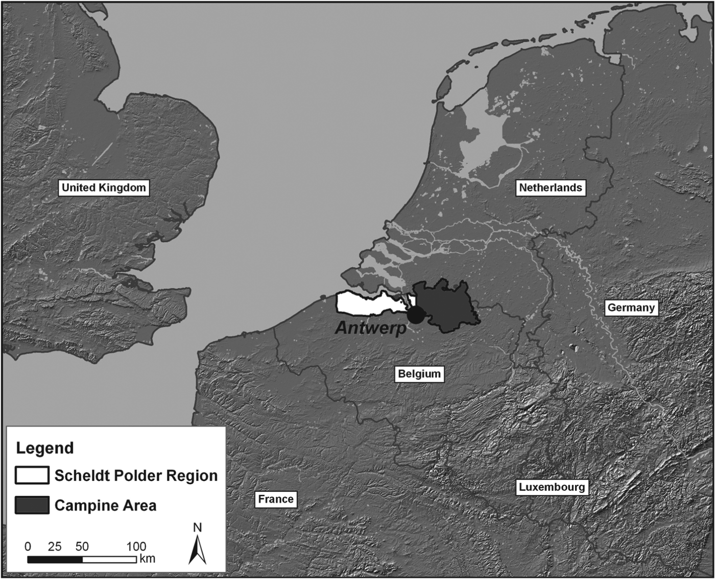
To answer this question, this article examines the cartographic evidence from two regions in the southern Low Countries, the Campine area and the Scheldt polder region, both situated in the densely populated and urbanised core of the Low Countries, and both within the immediate reach of major centres of cartographic production such as Antwerp, Bruges and Ghent (see Figure 1).Footnote 18
Map indicating the location of the two study areas (I. Jongepier).

Having equal access to technical knowledge, differences in the reception of cartography therefore cannot be explained by differences on the supply-side of mapmaking, such as whether or not land surveyors were involved in the production of local and regional maps, an element singled out by Paul Harvey as determining the spread of local-scale maps in sixteenth-century England.Footnote 19 The question remains how it was that such ‘expertise’ penetrated some areas earlier than others and why it became a political instrument in some regions but not in others. We will therefore consider the elements that hampered or stimulated the demand for accurate maps in the early modern period. The success and spread of cartography in a particular region, we will argue, can only be understood by looking at the ‘prehistory’ of cartography in that region, that is, we need to understand how space was constructed before the spread of geometrical maps in the sixteenth century. David Lord Smail has proved, using the case of medieval Marseille, that ‘textual maps’, descriptions of the urban landscape by notaries or clerks, were vital for the perception of space and for urban identity until the end of the eighteenth century.Footnote 20 Moreover, in addition to written documents, spatial performances, rituals and communal practices, such as visitations and processions, also played a major role in the active construction and appropriation of space. According to Nicola Whyte, visitations and processions provided both a powerful sense of the indivisibility of the physical experience of landscape and a demarcation of local social and economic relations.Footnote 21 Even in the eighteenth century, village communities in Devon and Kent still relied on processions and visitations to define their territory, according to David Fletcher.Footnote 22
In order to enquire which stakeholders relied on a ‘cartographic’ way of organising space, as opposed to alternative ways, we will concentrate on so-called ‘local’ or ‘regional’ cartography: maps of individual parishes or counties, maps of lands, forests and farms, which, as mentioned before, constituted the bulk of pre-modern cartographic production. Furthermore, it was not small-scale ‘national’ maps but large-scale local or regional maps that were essential tools in the defining of power within a territory, as they provided the owner of the land with a powerful instrument through which wealth, particularly taxable wealth, land and people could be controlled. To detect changing practices in the production and perception of space, and the role that mapmaking played in this evolution, we will concentrate on the delimitation of territorial boundaries. By looking at maps of territorial boundaries, the function of a map as an instrument of power used to create a hegemonic space can be explicitly tested. We consider developments from the thirteenth to the eighteenth century, allowing us to discern the long-term evolution of attitudes towards maps and mapmaking as instruments of power.
2. DIVERGING REGIONAL HISTORIES, DIVERGING CARTOGRAPHIC LEGACIES
In order to understand social relations, and the social production of space in both the Campine area and the Scheldt polder region at the dawn of the early modern period, we have to look back into the preceding medieval era. During the later Middle Ages, communities in both regions could be labelled as peasant societies, but ones where the regional lord and local elites had to reckon with powerful peasant communities who retained their independence cultivating smallholdings on which they enjoyed secure forms of tenure. Our first case study, the Campine area, had dry, sandy soil, with infertile heath lands, peat marshes and wet pastures in lower areas and along the many small rivers.Footnote 23 On the whole, the Campine ecosystem was a challenge to cultivate. Arable production was therefore concentrated on intensively exploited infields near each village. In addition, almost 80 per cent of the territory belonging to each village remained uncultivated and unenclosed, used as common wasteland by the local communities.Footnote 24 The political integration of the Campine area into the Duchy of Brabant only occurred in the twelfth and early thirteenth centuries, and the dukes of Brabant did not try to reduce the independence of the local peasant communities. On the contrary, in an effort to curb the strength of the local lords, they gave privileges to many village communities, guaranteeing personal freedom, political autonomy and market rights.Footnote 25 Some local lords nevertheless managed to retain seigniories Footnote 26 and they were joined, in the Burgundian–Habsburg period, from 1430 onwards, by a new class of ‘state’ nobility, who were entrusted with renewed seigneurial power over parts of the Campine area.Footnote 27 Apart from the nobility, the area saw the proliferation of important ecclesiastical institutions, such as the abbeys founded by the Norbertine or Premonstratensian order, which were equally favoured by the dukes of Brabant from the thirteenth century onwards. The common heath lands defined the Campine society: the local lord, an abbey or the Duke of Brabant himself typically owned this land, but the village communities were granted strong usage rights during the thirteenth century.Footnote 28 Important for our analysis, these vast, open heath lands proved difficult for any stakeholder to delimitate or claim. Since property claims were never clear-cut or simple, power struggles between neighbouring villages or even within a community itself were frequent.Footnote 29 In the early modern period, the Campine area retained its socio-political and economic structure even though the region adjoined the booming metropolis of Antwerp. Village communities proved resistant to change and defended their common rights, privileges and independent status. Therefore, no major shifts in the balance of power or any great economic transformations took place until the end of the eighteenth century.
Our second test case, the Scheldt polder region, formed the northernmost part of the County of Flanders. Following the Eighty Years War and the Treaty of Munster in 1648, the region was divided between the Dutch Republic in the North and the Habsburg Netherlands in the South. The environmental history of this region has been dominated by the estuary of the River Scheldt. From the mid-Holocene period, about 5,500 BC onwards, the region gradually turned into a freshwater marsh and became covered with a thick layer of peat. In the Roman period, renewed incursions by seawater and human exploitation of the peat meant that the region began to gradually acquire an estuarine landscape that would eventually consist of mudflats and salt marshes. The latter were gradually embanked from the High Middle Ages onwards, although periodic episodes of flooding would characterise the region throughout the medieval and early modern periods.Footnote 30 Not unlike the Campine area, medieval society in the Scheldt polder region was dominated by an independent peasantry living under the overlordship of the Count of Flanders. While local peasants were the first to engage in drainage and embankment activities in the region, from the twelfth century onwards they were joined by numerous abbeys and the Count of Flanders himself, along with wealthy citizens from the towns of Bruges and Ghent, all of whom had particular interests in the reclamation of the peat.Footnote 31 Within the dike, common land ceased to exist. However, the large stretches of un-embanked estuarine lands and undrained peat lands were considered as a type of common, claimed by both village communities in their vicinity, and, with increasing success, by the Count of Flanders.Footnote 32 While the medieval balance of power in the Scheldt polder region was not unlike the one in the Campine area, this changed in the later Middle Ages when the peasant smallholding economy in the Scheldt polder region virtually collapsed. Along with the rest of coastal Flanders, the region was heavily hit by the economic and demographic crisis of the later Middle Ages. In the Scheldt polder region the situation was exacerbated by huge storm floods and so-called ‘military inundation’ of the land during periods of civil war that took place in the last quarters of both the fifteenth and the sixteenth centuries.Footnote 33 The region was re-embanked, but, as in other coastal regions, embankment was usually undertaken by commercial entrepreneurs, backed by urban capital and state power, in the late medieval and early modern periods.Footnote 34 As a result, leasehold tenure came to predominate in the region and farm sizes increased considerably, turning the early modern Scheldt polder region into an area of large-scale, commercial cereal production, with only a minority of smallholders remaining.Footnote 35
In theory, the cartographic knowledge available in both regions was relatively equal. From the sixteenth century onwards both land surveyors – who were increasingly being trained at the Brabantine University of Louvain – and other cartographers produced a growing number of estate, territorial and dispute maps.Footnote 36 However, when looking at the cartographic legacy of both regions in more detail, a remarkable discrepancy becomes clear. As Harvey has demonstrated, regional diversity already existed in the limited production of local maps in the fourteenth and fifteenth centuries.Footnote 37 Over the latter centuries territorial cartography merely consisted of sketches, often produced in the context of a dispute or territorial claim, which aimed to lay out the situation of the village, land, watercourse or other landscape element in question. Whereas older literature on cartography often dismisses these vague sketch-maps as inaccurate predecessors of ‘modern’ map-making, they are now increasingly studied as maps in their own right. The regional variation in their production and use should also be taken into account.Footnote 38
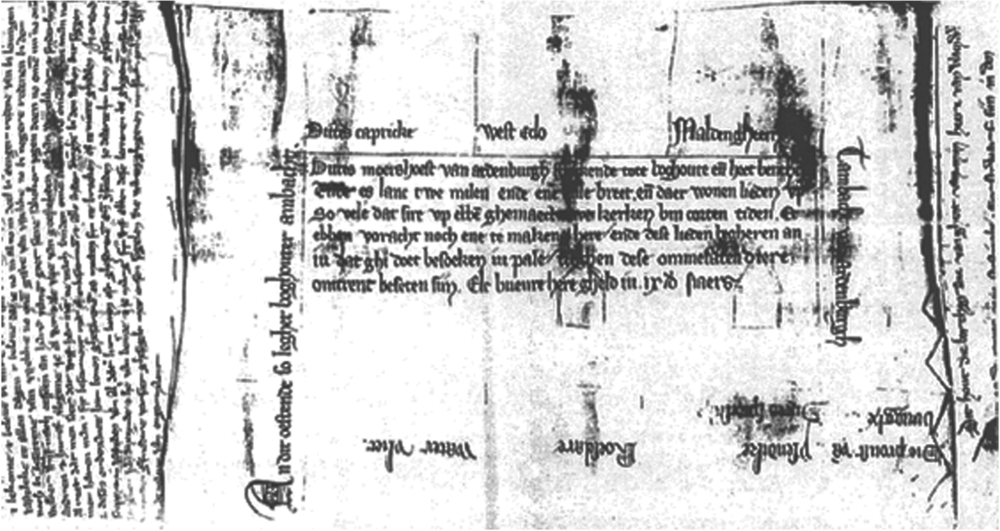
As far as the coastal region of the Low Countries is concerned, quite a few local sketches from the fourteenth and fifteenth centuries have been preserved. These show an increasing level of detail, and were mostly produced in the context of embankment projects or conflicts between different stakeholders (see Figure 2 for a very early example).Footnote 39
‘Map’ of the Moershoofd, or peat reclamation district of Aardenburg, c. 1300.
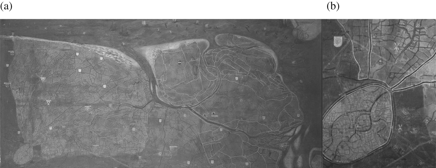
In the wake of the cartographic advances of the sixteenth century, coastal Flanders – like many other coastal districts in the North Sea area – enthusiastically embraced the possibilities of cartography.Footnote 40 Between 1561 and 1571, for instance, the Bruges painter and cartographer Pieter Pourbus produced a giant map of the castellany of Bruges (the so-called Heraldic Map of the Franc de Bruges, which can be found today in the Bruges City Archives), presenting a wealth of topographical detail (see Figure 3). Pourbus also included territorial boundaries, for instance the banlieu, or direct rural surroundings that belonged to the jurisdiction of Bruges.
(a) Territorial map of the district of Bruges (Franc de Bruges) by Pieter Pourbus, 1561–1571. (b) Bruges and its banlieu. Fragments.
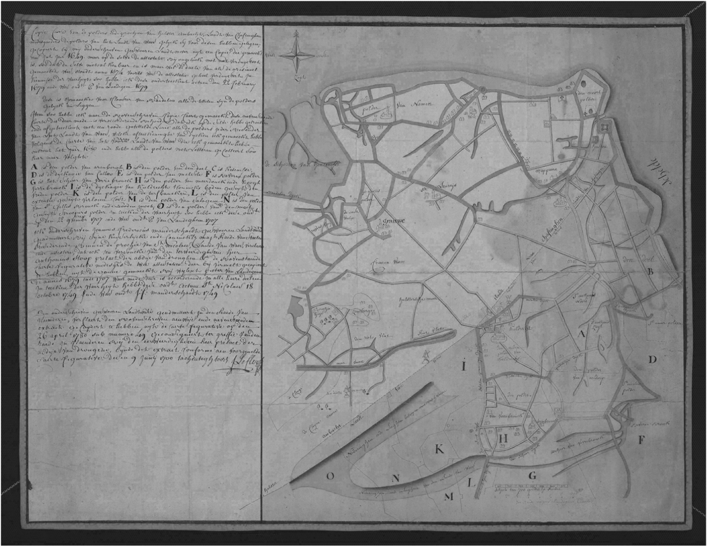
Very similar and detailed topographical maps were produced for other parts of coastal Flanders, for example those by François Horenbault, including his 1569 map of Zaamslag-Hulst.Footnote 41 In 1574 Horenbault was joined by three sworn lantmeters, or land surveyors, and they produced the only detailed territorial map of the Scheldt polder region on the left bank of the River Scheldt before this was flooded during the siege of Antwerp of 1583–1585 (see Figure 4). A territorial map is a map depicting political, administrative or jurisdictional boundaries of a particular region. This territorial map not only plots the location of dikes, tidal channels and villages, but also shows territorial boundaries, such as the boundary between the seigniories of Saeftinghe in the North and Beveren in the South.
Map of the Scheldt polder region by Franchois Horenbault, 1574 (copy J. Leclercq, 1780).
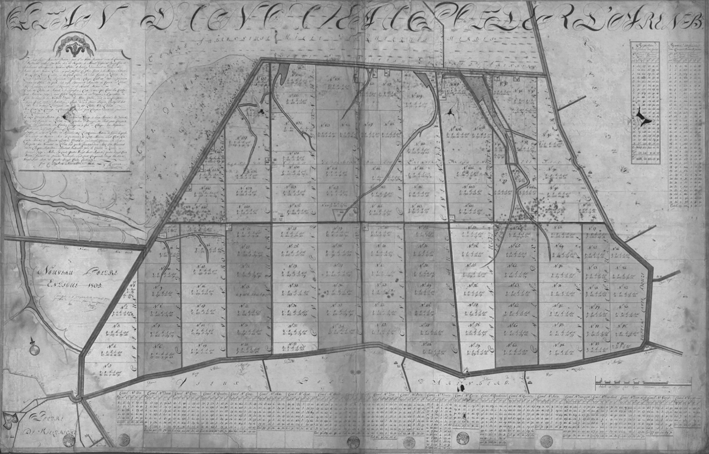
During the seventeenth and eighteenth centuries, the Scheldt polder region was intensively mapped. For each and every polder, village, seigniory or estate, several detailed maps, based on accurate surveys by official surveyors, have been preserved (for an example, see Figure 5). The prime goal of these maps was fiscal, to aid the levying of the land tax, but as we will see below, these large-scale maps also provide evidence of a changing attitude towards space.
Map of the Nieuw-Arenberg polder, 1806.
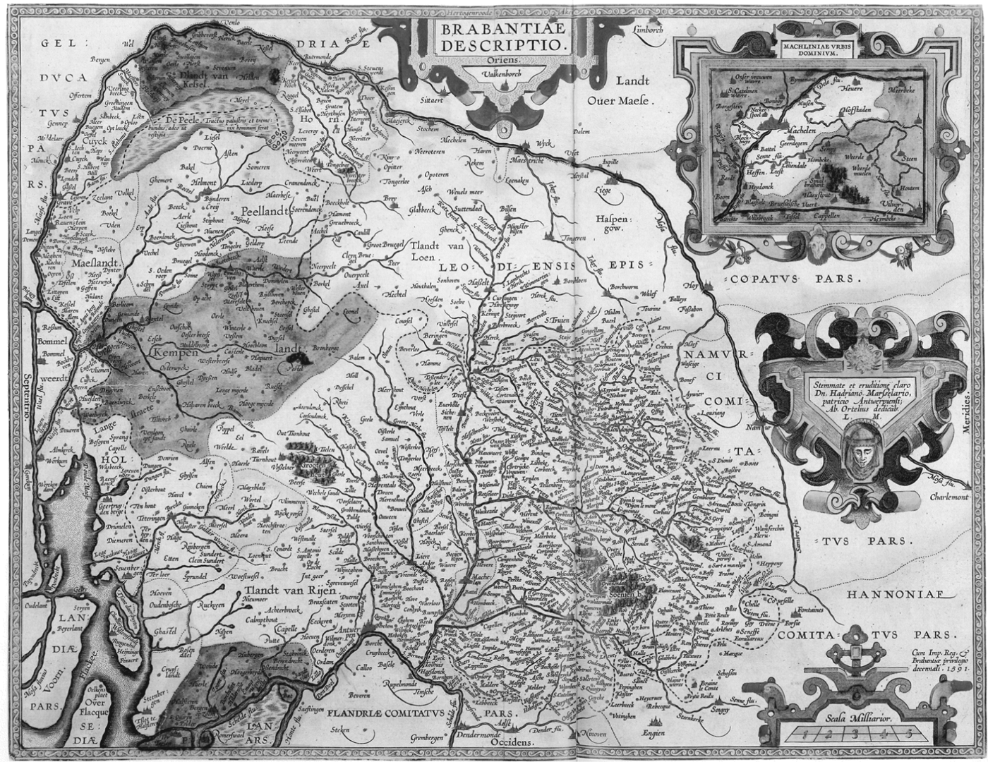
The different stakeholders of the Campine area showed much less enthusiasm for cartography. Even though the area was regularly depicted on small-scale territorial maps of the Duchy of Brabant (for an example, see Figure 6), no specific large-scale maps were created. Moreover, the accuracy and details of the maps that did exist were far from perfect.
Example of a small-scale, territorial map: Brabantiae, Abraham Ortelius, 1592.
The maps produced in many other regions of north-western Europe were also vague and lacked detail.Footnote 42 Apparently, in some regions no investment was made in territorial maps; they were not seen as capital goods with which to reorganise or perpetuate power claims. In fact, for most of the Campine villages, the famous Ferraris map of c. 1771–1778, produced by the artillery section of the Austrian army under the supervision of the Count de Ferraris, was the very first map to depict the whole of their territory with a high degree of topographical detail.Footnote 43
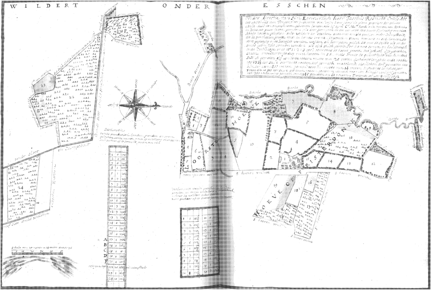
The production of large-scale maps of individual estates, villages or seigniories in the Campine area also lagged behind that in the Scheldt polder region, although the picture is more nuanced. In the seventeenth and eighteenth centuries, the Campine abbeys were very active in ordering sumptuous maps depicting their estates in great topographical detail (for an example, see Figure 7). These maps had an administrative function but also represented an important degree of symbolic capital, showing the wealth and status of the abbey.Footnote 44
Map depicting the tenant farmstead of the abbey of Tongerlo, 1692.
The seventeenth- and eighteenth-century estate maps produced for the Campine abbeys show that maps and cartographical skills were not lacking in this area. However, these maps were mostly limited to the abbeys’ own estates. The kind of large-scale maps of whole villages, detailing individual plots with a sufficient degree of topographical accuracy, which became very frequent all over Flanders in the course of the seventeenth and eighteenth centuries, remained limited to some individual and exceptional endeavours of, for example, ecclesiastical institutions depicting their estates. Elite groups used maps for various reasons, but alternative methods were preferred well into the eighteenth century for perpetuating power claims or territorial interests. Just as Christopher Lloyd and Keith Lilley argue for medieval maps, the apparent lack of accuracy or veracity of the early modern Campine maps should not be interpreted as a sign of backwardness, but rather as a reflection of the norms, values and purposes of the mapmakers.Footnote 45
3. THE PREHISTORY OF MAPS: TEXTUAL MAPS AND THE IMPLEMENTATION OF BOUNDARIES
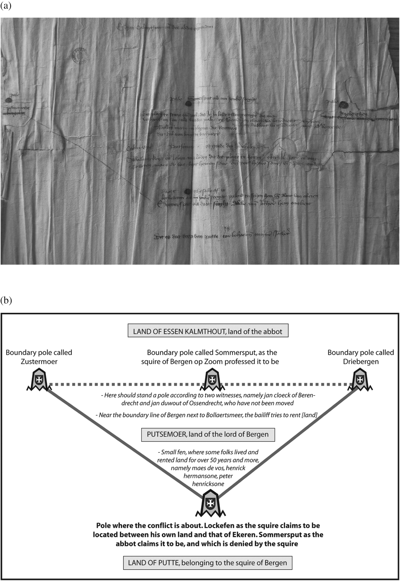
Maps were not an ordinary part of everyday life in medieval Europe. To give directions or show the boundaries of a property in the Middle Ages, written descriptions would be composed.Footnote 46 Smail has called these kinds of document ‘verbal’ or ‘textual’ maps, where the material world was translated into descriptions of nodes of social focal points, cultural centres and areas of production, rather than an abstract or geometric image of reality. The use of street names and a schematic representation of a place via a bird's-eye view to portray a city landscape were developed much later.Footnote 47 For local and rural boundaries similar textual sources such as records of perambulation, sources describing the public visitation of the territorial boundaries, were used until well into the eighteenth century.Footnote 48 In the Campine area such textual maps can be found in abundance in the grants and charters that were used to perpetuate boundaries and limits of all kinds, including local territorial boundaries. This was the way that legal spaces were created. As only a selective view of reality was described, these documents often omitted most details referring only to limited numbers of boundary markers were mentioned – typically 5 to 15, mostly wooden stakes or environmental elements – even for an area of several square kilometres encompassing several different villages. Verbal maps remained silent about any real and helpful details, symbols or recognisable boundary elements. As a result, the actual boundary line remained rather vague both in practice as well as in written documents.Footnote 49 As we have seen above, little sketches sometimes accompanied juridical sources. These ‘maps’, such as the one in Figure 8, were only an abstract visualisation of the written documents, rather than an independent map. Without the text, nobody could ever locate or interpret any of the elements depicted in the sketch, but the latter helped to re-enact the narrative of the dispute or the claim in a graphic way.
(a) Juridical sketch map of 1440, attached to the juridical files.
Charters were not, and could not be, the only tools used to demarcate a seigniory. In a medieval context, power also had to be demonstrated and ‘performed’, and, through this performance, accepted by other parts of society as well.Footnote 50 If lords wanted to transform contentious border zones or vague limits into political sites that represented their hegemony and power, a process of self-representation had to be developed in order to create a cohesive space, one recognised and accepted by all other interest groups. In order to create such a dominant and shared perspective of space, the users of these boundary spaces had to be convinced of this creation. Fletcher, for example, has demonstrated in the case of England that boundary visitations were not only one of the most important social events in the annual calendar, but also served the practical purpose of demarcating the parish boundaries.Footnote 51 In order to determine the boundaries the entire community was summoned and during a day of festivities and social events, the boundaries were ‘visited’, that is, the community walked round them together. Oral wisdom and the memory of the eldest and wisest community members were the most important sources of information. Fletcher stated that this was one of the most inclusive forms of administration and politics within the pre-modern village, since the knowledge and acceptance of the boundaries only increased when the proportion of the community aware of the boundaries increased.Footnote 52 The charter of Kalmthout-Essen describes the delimitation of the village boundary with the term Driebomende, which literally means metrically paced-out limits.Footnote 53 In the fifteenth century, details of these rituals become abundant thanks to the earliest recorded Campine boundary disputes. In 1441 a visitation was organised by the ruling elites of Kalmthout-Essen. It had to be attended by at least the bailiff of Brabant, the sheriff of the manor and aldermen of the community.Footnote 54 Community members were not mentioned, but these being institutionalised practices, known in most village communities throughout early modern Europe, they were probably present. When all parties were gathered, the crowd or procession ‘paced off’ the boundaries of the manor. References have been found that it was a requirement that the boundary markers had to be touched to indicate that they were acknowledged as legitimate symbols. At each marker, all the parties had to publicly declare they recognised these stakes as legitimate or not, before the procession could continue.Footnote 55 The ruling elites thus used institutionalised rituals to show their power and publicly demarcate their jurisdiction. By visualising limits in a very literal way instead of via abstract maps, and by involving competing interest groups, the elites tried to safeguard the manorial boundaries as they conceived them to be.
Nevertheless, the adoption of this elitist perspective on the nature and function of boundaries was hard to secure. Different interpretations and competing appropriations of the same spaces always remained in existence. A striking example was a conflict between the abbey of Tongerlo and a neighbouring Lord of Bergen op Zoom over the right of pasture on the commons of the manor Kalmthout-Essen in 1440. A century after the original delineation of the commons, tensions began to arise about the exact location of two boundary markers on the heath lands. Herdsmen who crossed the border between the two manors were arrested by the sheriff of Kalmthout. Yet both local villagers and the ruling elite of Putte claimed that they possessed the right to graze their animals on the piece of heath land in question. According to the ruling elites and the Lord of Bergen op Zoom, they possessed plots of private property of Putte, so that the area could be used as grazing ground for their sheep. Kalmthout and the abbey of Tongerlo, on the other hand, claimed that two fens, Schommersputte and Bollaartsmeer, were the official boundary markers according to the foundation charter of Kalmthout-Essen. Since the Lord of Bergen op Zoom doubted these boundary markers, witnesses and officers of the manor and neighbouring villages were ordered to be present at the visitation of the limits and had to declare which natural or man-made elements were the rightful boundary markers.Footnote 56 This indicates that no agreement existed between the two lords and the strategy to visit and indicate environmental elements as boundary markers was not convincing enough for the plaintiff, nor for the defendant and the court. As a result the court fell back on local traditions and modes of mediation, namely collective visitations and testimonies at the actual site of the boundaries.Footnote 57 Even though interests could clash again, in the long run, these public displays were the most efficient way for the ruling elites to demonstrate, and impose, their vision of where boundaries lay.
Underneath this ‘elite-driven’ active construction of space, yet another attitude existed. In some instances, we see that the elite perspective on boundaries was challenged by a totally different mode of appropriation and concept of space. The same principle was discovered by Smail for medieval Marseille. During the sixteenth century, those notaries working at the episcopal palace in the city systematically referred to urban space using the word ‘quarters’, while other notaries in the city all accepted and employed a uniform style of reference to the same space which was based on street names.Footnote 58 In the case of the Campine area, the elites might have quarrelled about the exact location of the boundaries but they shared the same concept of a linear, strict and hierarchical boundary, which shaped and emphasised their power. It would appear, however, that peasant communities maintained a separate belief. Their testimonies given in court show that most villagers actually did not know, or rather did not want to confirm, the exact location of the borders or the names of the fens that were supposed to be markers. One member testified that ‘He had never heard someone mention the name of Schommersput, but that he did know that folks used these lands to graze their animals, cut heather and timber’.Footnote 59 As we can deduce from village bye-laws, Campine community members performed their basic agricultural practices in a communal manner and this latter was determined by rules, symbols and traditions. Herdsmen had to drive their sheep and cattle along pre-defined roads, during prescribed periods and in particular areas.Footnote 60 Zones were appointed according to the type of agricultural practice. These collective sheep drifts created zones of agricultural performance: grazing on selected heath lands, drifting to watering places and collecting the sheep in folds during the night. Being perfectly aware of the importance of herding sheep in their common heath lands, boundary zones and zones of contact between neighbouring communities were preferred to linear limits. Since lords were unable to impose their conception of boundaries on the peasant communities, they had to accept the co-existence of different perceptions of the territorial boundaries. The bottom-up perspective of boundaries, created by a repetitive performance of crossing the village limits used by herdsmen and farmers, was translated into the materialisation of vague border zones, in which markers were kept to a minimum.
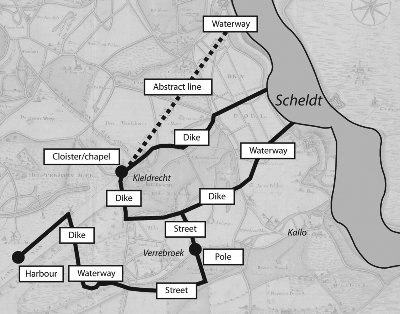
In the Flemish Scheldt region, detailed information on the delimitation of territorial boundaries became more readily available from the twelfth century onwards. Most of these delimitations took place in the context of reclamation activities. In 1257, for instance, when the Count of Flanders and the Lord of Beveren engaged in more intensive reclamation of the vast peat district near Kieldrecht and Saeftinghe on the left bank of the river Scheldt, the Bishop of Tournai marked out the boundary between ‘his’ parishes in the Waasland territory and the adjacent seigniory of Saeftinghe, which fell under the bishopric of Utrecht. In this and similar cases, the newly constructed boundaries typically consisted of a combination of pre-existing ‘natural’ and ‘man-made’ landscape elements such as water courses, dikes and streets, purpose-built poles or crosses and virtual, linear boundaries between two points, in this case the village of Kieldrecht and the Scheldt, as shown in Figure 9.Footnote 61
Boundaries of 1257.
Just as in the Campine area, the visualisation of boundaries was not clear and convincing enough. Delimitations of jurisdictions, such as the one carried out by the Bishop of Tournai in 1257, also had to be performed through a circumitio, a ceremonial tour of the area to be delimited. Such ceremonial tours greatly resembled the numerous religious or civic processions that gave colour to medieval urban and village life.Footnote 62 To ensure impact, they invariably required the attendance of an elaborate audience, and we can surmise that when the Bishop of Tournai, or his representatives, marked the boundary between the Land of Waas and the Land of Saeftinghe, local elites and officials certainly attended the show. We are even better informed on another type of boundary construction in the Scheldt polder region. This took place every time new pieces of marsh or peat land were enclosed and was called the equitatio, a feudal ritual that required one of the court officials of the Count of Flanders to ride round the land on horseback preceded by someone blowing a horn.Footnote 63 The equitatio perpetuated the actual enclosure by showing this latter to the local inhabitants and worthies. This demonstrates a form of ritualised top-down boundary construction that, nevertheless, required a minimal level of participation by local inhabitants, as we will state.
Just as in the Campine area, ordinary inhabitants in the medieval Scheldt polder region did not always comply with the boundaries imposed on them by their betters. When the Bishop of Tournai delimited his jurisdiction in 1257, the village community of Kieldrecht raised objections.Footnote 64 According to the villagers the boundary cut through an area that had always been used by the community and could not, therefore, be alienated from them. Although their objections were not accepted, it is significant that the opinion of the local community about the boundaries was voiced during the proceedings of the episcopal court. As in the Campine case, the resistance by the inhabitants of Kieldrecht draws attention to two different constructions of space: linear, juridical boundaries on the one hand, and boundary zones observed in everyday practice on the other hand. Activities such as cattle or sheep herding, reed cutting and wood gathering did not easily comply with strict linear boundaries.Footnote 65
4. TOWARDS AN EARLY HEGEMONY OF MAPMAKING IN COASTAL FLANDERS
In the later Middle Ages, before the ‘cartographic revolution’ of the sixteenth century, spatial practices in the Scheldt polder region began to change. As we will see, verbal maps such as land registers became increasingly geometric and based on land surveys using modern geographic descriptors. Instead of simply mentioning the plots and perhaps an indication of their size, they were described in detail, listing their exact size, located by their wind direction or street names. This testifies to a ‘geometric’ way of organising space before the actual spread of cartography. As early as the end of the thirteenth century in the Scheldt polder region, the equitatio mentioned above was being replaced by measurements done by land surveyors.Footnote 66 Detailed measurements of drainage and embankment systems and of landed property became common practice in the later Middle Ages. This is most clearly seen in the appearance, during the fifteenth century, of a specific type of land register, the so-called ommeloper. This must be considered as one of the most superb examples of a geometrically ordered, textual cartography. In a systematic way, the land surveyor described every single plot within a given territory, describing its shape, size, owner, particular distinguishing features and geographical location, based on a grid of roads, waterways, and compass directions.Footnote 67 As such, this kind of source was nothing less than a direct precursor to the modern ‘cadaster’ or land register. Between 1456 and 1560, a large water board such as that of Blankenberge, north of Bruges, measuring c. 15,000 hectares, ordered several new surveys, each of them resulting in monumental volumes depicting more than 12,000 plots of land. This practice introduced a most systematic and modern way of territorial organisation. It was of particular use to large landowners, both in the administration of their landed estates and in the monetarisation of the fiscal system, which, of course, disadvantaged smallholders who preferred payments in kind to those in cash.Footnote 68
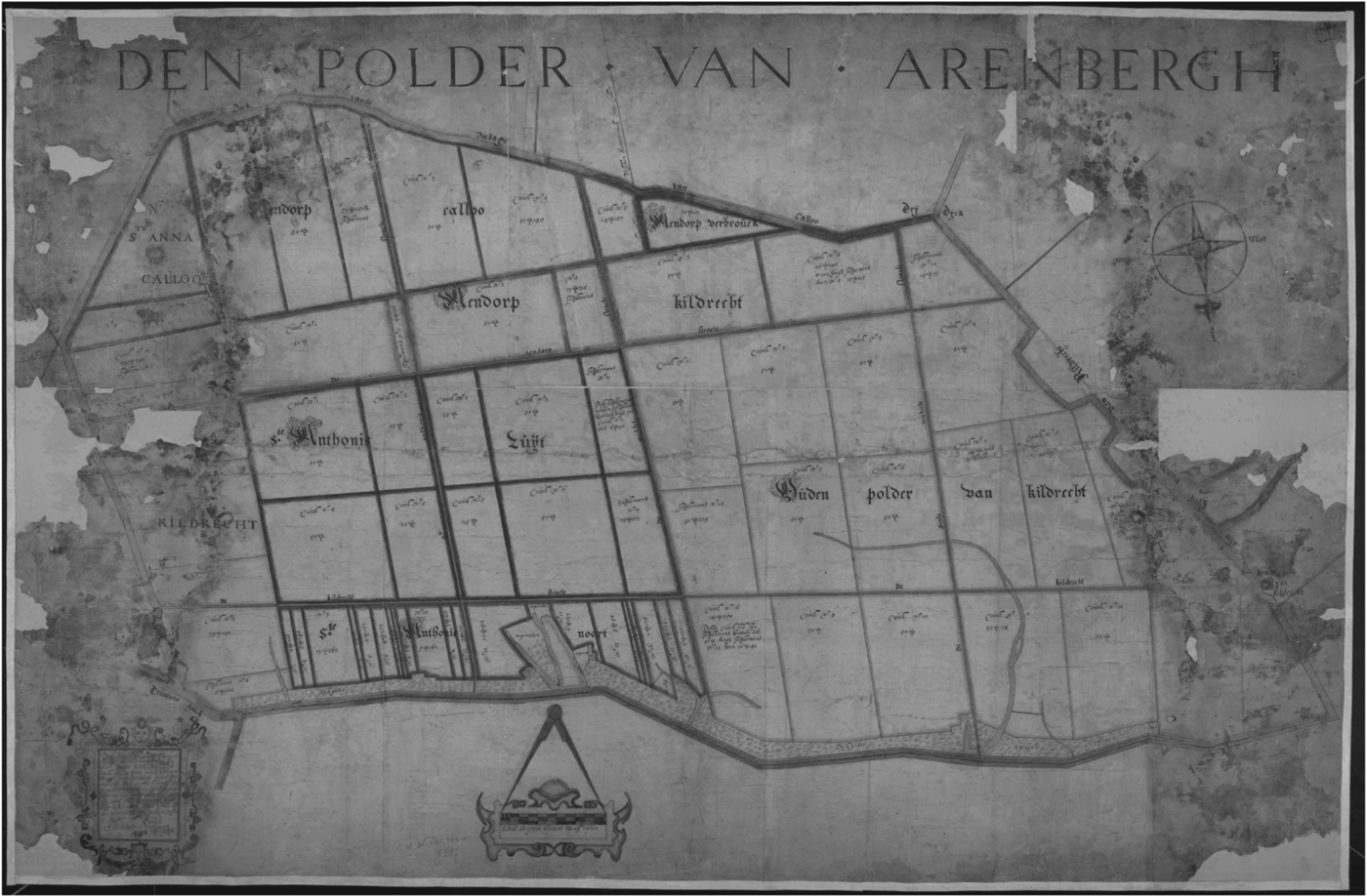
The availability of such detailed ‘geometric’ inventories as early as the end of the fifteenth century certainly helps to explain the rapid adoption of cartography in the sixteenth century in these coastal areas. Whereas the rapid success of cartography in coastal Flanders certainly testifies to a changing perception of space, it also became instrumental in turning this geometric and commoditised form of space into a dominant one. In the coastal region cartography even began to affect material space itself. This is most clearly seen in the many drainage projects started in the coastal region during the early modern period following the floods and inundations of the fifteenth and sixteenth centuries. Many areas had been depopulated and the former power of village communities, which had already been weakened by the steady decline of peasant smallholdings over the course of the fourteenth and fifteenth centuries, was annihilated. Just as Gordon has argued with respect to London after the Great Fire of 1666, this destruction of the previous production of space would pave the way for a new, geometric definition of space delimited by new, geometrical boundaries. From the early seventeenth century onwards, the flooded areas were gradually re-embanked by commercial consortia of entrepreneurs and financiers, who became active in land drainage and embankment projects all over the North Sea area.Footnote 69 The embankment permit or license (octrooi) granted by the central government of the Habsburg Low Countries almost invariably implied that land surveyors were instructed by the political elites ordering the embankment to make maps of the new embankment. In 1650 a license prescribed that ‘the grantees will have to submit to the council of State a perfect map of the land and jurisdiction’.Footnote 70 In 1688 it was ordered that ‘the sworn land surveyor has to do the separation and division concerning the plots next to ditches’.Footnote 71 Land surveyors and cartographers thus started to design abstract grids and plans, with geometrical allotments, roads and ditches, which were subsequently implemented in the real landscape. This resulted in wonderful artwork on the maps, depicting a perfectly man-made and rational landscape, without the imperfections caused by the natural landscape development or previous stages of human occupation (for an example, see Figure 10).Footnote 72
Map of the Oud-Arenbergpolder (1688), showing the newly imposed geometric property structures of this new embankment.
On its own the instrumental use of maps was not very exceptional. As mentioned above, state- or city-driven incentives to depict and subsequently implement their ideal version of landscapes, to meet political ends, were quite frequent. Vesa-Pekka Herva and Timo Ylimaunu have shown, for instance, the power of mapmaking as an instrument to reconstruct space in the case of seventeenth-century Sweden. Not surprisingly, when the Swedish government was expanding its political power in the Baltic and attempted to transform the heterogeneous and geographically loosely defined monarchies into absolute and internally homogenised states, maps depicting their ideal and imagined landscape were used as powerful political instruments. They did not passively describe the world but influenced the world view of the percipients of these maps to a vision of what the world should have been like according to the Swedish government.Footnote 73
One might have expected that the hegemony of the geometrical, ‘cartographic’ way of boundary construction would provoke resistance. In the course of the seventeenth and eighteenth centuries, numerous lawsuits were initiated by wealthy landlords regarding the location and ownership of land – with its tithes and rents – that had been drowned and later re-embanked. Most of these lawsuits did not bother with the topographical location of an often ancient boundary. When formerly flooded tithing districts had to be reinstated after the embankment of an area, stakeholders often preferred to share the profits of the land rather than resurrect old boundaries.Footnote 74 A similar claim on rents near Meerdonk, initiated by the abbey of Drongen around 1765, was settled by simply reassigning old rents to new plots distributed at random, without taking into account the former estate boundaries.Footnote 75 This was in line with the idea of a ‘blind lottery’, prescribed by many drainage licenses as the proper way of assigning land to the investors in a drainage project.Footnote 76 Such conflicts do not reveal fundamental disagreements in relation to the concept of territorial boundaries. At best there were competing claims over property rights of certain pieces of land. It seems that the new geometrical boundaries created on the drawing tables of cartographers or land surveyors were actually accepted, and that, at least among the upper layers of polder society, a social consensus existed on the definition and application of these boundaries. Only a few eighteenth-century lawsuits reveal a glimpse of what might have been a competing boundary construction. The first disputeFootnote 77 arose in 1721 to the south-west of Kieldrecht. A treaty between the Spanish Crown and the Dutch Republic of 1664 had specified the borders between the northern and the southern Netherlands. The boundary resulting from this treaty was drawn on a map but was not immediately materialised in the landscape through the placement of markers. In marginal areas – the Wilde Landen – in between Sint Janssteen, which belonged to the Republic and the Waasland, which belonged to the Habsburg monarchy, the boundary remained unclear. The council of Sint Janssteen initiated legal procedures in order to tackle problems with ‘some pagan or Egyptian people, wastrels, tramps, vagabonds and in general all suspicious persons’,Footnote 78 who apparently used the undefined character of the boundary to escape justice. As a result of these processes the vague, earlier border was replaced by a clear-cut and well-defined boundary, following both watercourses and roads and demarcated by four new marker poles. Whereas elite groups largely agreed on the idea of linear, geometrical boundaries, conceived on a map from the sixteenth century onwards, there were other groups in society that transgressed boundaries in their daily activities, deliberately or not. Like the supposed ‘criminals’ in the Wilde Landen, they were often deemed ‘marginal’ and their voice was not easily heard in court, except when they were sued by the government. Coastal Flanders thus confirms Mukerji's prediction that once one group of stakeholders could impose their spatial vision on others, maps would become hegemonic.Footnote 79
5. THE SURVIVAL OF COMPETING SPACES IN THE CAMPINE AREA
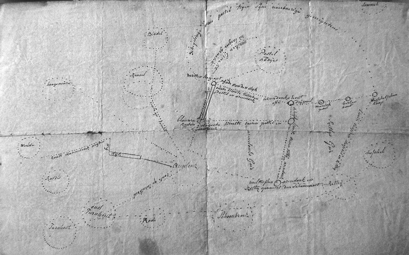
As mentioned above, the spread of cartography was much less pronounced in other parts of the Low Countries, including our second case study, the Campine area. In this region, on the one hand we saw the production of sumptuous estate maps, ordered by monastic institutions and lay lords from the seventeenth onwards, and, on the other hand, an almost complete absence of detailed topographical or cadastral maps showing individual villages, parishes or districts.Footnote 80 Abbeys such as the Premonstratensian one at Tongerlo commissioned land surveyors to measure and make inventories of their estates as early as 1510. The owner or occupier, the land surface, and land use and location of particular plots of land were all described, although the location was given with less precision than in contemporaneous sources in the Scheldt polder region.Footnote 81 In the seventeenth century lavishly decorated maps were added to the written sources, which resulted not only in beautiful but also surprisingly accurate estate maps, and these were then collected in atlases.Footnote 82 Apart from these sumptuous estate maps of the Campine abbeys, however, territorial maps of the region were vague and lacked detail; they were merely figurative without any topographical elements or triangulation.Footnote 83 Apparently, the Campine village communities, landlords and even the Duke of Brabant had no appetite for prestigious maps or drawings of their jurisdictions. There are few sketches or abstract depictions of their seigniories, cities or other power symbols, such as estates or exploitation centres, which contain territorial boundaries. Compared with the Scheldt polder region, this situation may seem striking, yet when other peasant societies are drawn into the comparison this lack of maps comes as less of a surprise. According to Fletcher, even in eighteenth-century Devon and Kent, maps were the exception rather than the rule.Footnote 84 Therefore, textual mapmaking remained dominant. In the course of the seventeenth century, charters listing boundary markers and jurisdictional limits – the type of non-geometric ‘verbal maps’ we discussed above – were sometimes accompanied by sketches. Both the topographical accuracy and the symbolic strength of such sketches, like the one in Figure 11 which shows the territorial boundary of Arendonk through the common heath land, drawn up during a dispute with the abbey of Postel in the later seventeenth century, remained limited.
Dispute map between Arendonk and Postel, 1665–1699. Rijksarchief Antwerpen, Belgium, Oud Gemeentearchief, Arendonk, 721.
Maps like that shown in Figure 11 were so vague and unrevealing that one can hardly believe that any boundary dispute was ever resolved by them. Furthermore, when looking at boundary disputes settled before the council of Brabant, maps were seldom or never ordered by either the defendant or the plaintiff and, in fact, rarely ever functioned as decisive evidence. Although maps were almost always mentioned in the court proceedings, arguments or sentences were never based solely on maps.Footnote 85 One defendant even objected to the use of maps as evidence for he considered them vague and prejudicial. He argued that the land surveyors employed to draft the maps were invariably biased.Footnote 86 During another conflict, members of the community of Arendonk stated of the defendant, ‘… the abbey of Postel has created as many maps as they have met opponents, so they can expand their territory like a peacock opening up its tail into a fan’.Footnote 87
Why did Campine villages not invest in detailed and correct territorial village maps? Furthermore, why did Campine lords confine themselves just to depicting their real estate and refrain from ordering detailed maps of the areas over which they had jurisdiction? It has been claimed, for example by Fletcher, that regional and national players had no real interest in visualising the local level and that the rural communities themselves were too familiar with the actual landscape to engage in drawing maps of their surroundings.Footnote 88 In our opinion, however, neither poor technical skills nor the lack of interest in mapmaking are a satisfactory answer to these questions. The existence of estate maps and cartographic inventories immediately rules out the first argument. The latter can be refuted by focusing on seventeenth-century boundary disputes. For instance, an analysis of such disputes in the Land of Turnhout, a seigniory which was part of the Campine area, shows that the manorial lords, along with the abbots of Postel and Tongerlo and administrators from the villages of Ravels, Retie, Turnhout and Arendonk, did try to produce a space composed of hierarchal boundaries and strict linear limits. For example, the village government of Arendonk stressed that a written report of the recurrent boundary control of the seigniorial boundaries mentioned a straight line, while a dispute ‘map’, or rather ‘sketch’, depicted a curved one. This discrepancy had to be solved immediately by the placement of new markers on the land.Footnote 89 Yet the production of a territorial map to replace the juridical sketches was never requested by any of the elite stakeholders. As Mukerji has argued, maps could easily replace memory and collective visitations in order to re-organise patterns of power and space, but only once political, economic and cultural life was organised to fit the interests of one stakeholder.Footnote 90 In the Campine area, this hegemony was never achieved during the Ancien Régime. The power of local lords – and the Habsburg state – remained permanently contested by well-organised village communities who, in contrast to their neighbours in the coastal region, were able to maintain their medieval privileges and political autonomy. Therefore, top-down constructions of space were seldom implemented easily. As a result, the Campine elites still needed to negotiate with the peasant communities during the seventeenth century, as they did in previous centuries. Therefore, village elites instigated collective visitations to visualise their authority and the territorial claims of their communities. Both the inhabitants of neighbouring villages as well as local community members had to be convinced of the validity of the latter's claims.Footnote 91 This permanent need to show and negotiate boundaries promoted the survival of ‘medieval’ collective rituals of boundary demarcation until the end of the eighteenth century, not unlike those described by Fletcher and Whyte for some parts of England.Footnote 92 Following the abstract descriptions of their textual maps, the Campine communities paced out their parish boundaries which ran through vast heath lands, together with their neighbouring communities and villagers, as was the practice for boundary marking in general. Not all rituals, however, had the desired effect.Footnote 93
Nevertheless, the Campine villagers still herded their sheep on their common wastelands irrespective of village or manorial boundaries. The early modern villagers and herdsmen benefited from vague borders and the possibility of crossing territorial boundaries into neighbouring lands. Clear-cut boundaries would have impeded this. During a lawsuit of 1743, when witnesses were heard, Laureys Beckers, a labourer and villager of Oosthoven, a hamlet of Turnhout, stated that he knew the village boundaries, but had always identified the area by his peaceful use of the common wastelands instead of through symbolic demarcations, such as boundary poles or environmental elements. The same image was invoked by other witnesses and even by administrators such as church officials.Footnote 94 Boundary zones, instead of linear boundaries, were necessary for both herdsmen, who had to drive their sheep onto vast heath fields in order to feed their animals and prevent overexploitation of the wastelands, as well as for villagers who needed flexible rules to allow them to cut sod and dig peat on the heath land. These communal practices, which had been tolerated and even institutionalised through bye-laws, were crucial to the Campine agrosystem. The Campine peasant society had enough vitality to resist the top-down pressures to delineate the manors and jurisdictions. Even though the symbols and markers of the elite were known and collectively visited, no shared perspective of the function, usefulness and definition of boundaries was formed until the eighteenth century. Both visions of the local area existed side by side in the same villages and regions, and this prevented mapmaking and geometrical space from gaining hegemony. The spatial organisation of the Campine area, and the way it was perceived by the population in the eighteenth century still resembled the medieval situation, and so did the conflicts that resulted.
It was only from the eighteenth century onwards that the central government accumulated a sufficient degree of political hegemony with which to break the local resistance to mapmaking. Starting in the second half of the eighteenth century, maps were increasingly drawn of Campine villages, a process that was intimately linked to the efforts of the central government, backed by local elites, to enclose or reclaim the common heath lands.Footnote 95 Only when village communities were stripped of their privileges could a geometric, top-down construction of space become hegemonic and the area finally be fully mapped.
6. CONCLUSION
Thanks to advances in triangulation, cartographic production witnessed exponential growth from the second half of the sixteenth century onwards. For the first time, maps became a practical instrument with which to define, administer and control territories and people – a role they would never lose again. It is often presumed that with mapmaking came a new, geometrical and unequivocal way of representing and constructing space, eagerly embraced by the early modern states. What, at first sight, seems to be a story of a technological breakthrough initiating changes in spatial practices and territorial administration does not hold when one looks in more detail at the highly divergent experiences and practices concerning space both before and after the ‘cartographic revolution’ of the sixteenth century. In this article we have demonstrated that even neighbouring regions with similar access to cartographic knowledge and production often reacted very differently in the way they adopted and used mapmaking. The explanatory force of cartography itself turns out to be rather limited. Instead we found we had to look for elements that could explain regional divergence in both the spread and agency of maps. Following previous studies that emphasised the history of power in the early modern construction of material space, we demonstrated that different constellations of regional power resulted in either a rapid consensus on the use of cartography as the major tool to represent and reshape material reality, or in prolonged competition between alternative means of spatial representation. In our first case study, the Campine area, only some actors, such as the large Norbertine abbeys, embraced mapmaking at an early stage to pursue their private patrimonial interests. No consensus on mapmaking occurred, as well-organised village communities actively or passively counteracted the implementation of territorial mapmaking and geometrical representations of space, especially where the vital common heath lands were concerned. At the same time, in our second case study, the Scheldt polder region, all political and economically predominant actors after 1500 shared a preference for geometrically represented and constructed spaces, guaranteeing clear and unequivocal power claims and property rights. In this context the appeal of mapmaking occurred both early and on a massive scale, becoming an uncontested and powerful tool with which to reconstruct material space.
Second, we have demonstrated that maps, as pictorial sources, are insufficient to fully understand the evolving production of space. Our attention was directed at what could be called the prehistory of mapmaking: spatial practices and representations of space before the sixteenth century, which, as Smail demonstrated for the city of Marseille, made a great impact on the social and regional adoption of mapmaking in the early modern period. The highly geometric and systematic ‘textual maps’ that had already become popular instruments of spatial organisation and fiscal control in the Scheldt polder region in the fifteenth century no doubt fostered the easy adoption of cartography from the sixteenth century onwards. Furthermore, alternative modes of actively constructing space, including spatial performances such as pacing off and crossing boundaries, or textual maps, often coexisted with mapmaking for a long time. A construction of space through performances in particular fitted situations in which space needed to be constantly negotiated by different interest groups. In this respect, it is highly significant that the popular medieval practice of ceremonial processions as a way of delimiting boundaries had already begun to disappear in the Scheldt polder region during the fourteenth century, but survived in the Campine area until well into the eighteenth century. Only the latter region remained characterised by political competition between actors with divergent concepts of space, keeping a need to negotiate space alive. In this region, alternative, more ‘bottom-up’ concepts of space could not be easily overrun by the linear and geometric space depicted by cartography. We would argue this provides a strong case for a social history of cartography to be written, one that considers the views of the different consumers of maps, the highly divergent ways these consumers organised and constructed space and the role mapmaking did, or did not, play in the permanent effort to shape and reshape material reality around them.
ACKNOWLEDGEMENTS
The research reported in this article was enabled by two research grants from the University of Antwerp Research Council, Belgium. A first draft of this article was presented at the Sixth European Society for Environmental History Conference in Turku, Finland in June 2011. The authors would like to thank the participants in the session on ‘Contesting land and water in pre-modern Europe’ for their valuable suggestions and remarks. We would also like to thank several colleagues of the Antwerp Department of History, as well as the anonymous referees, for their comments on earlier drafts. For language correction, the authors are indebted to Imke de Gier.