

INTRODUCTION
Over the past forty years, the indigenous people of northern Canada have engaged the federal and territorial (or, in some cases, provincial) governments in the negotiation of comprehensive land claim and self-government agreements. These modern treaties spell out the nature of government-to-government relations among the signatory governments and grant northern First Nations real (if limited) powers of self-government and a role in the management of northern lands and resources. As a result, First Nation governments across the Canadian north have emerged as significant players in regional politics. This is very different from the days, not so long ago, when they lived under the colonialist dictates of the federal Indian Act and had virtually no say either in their own governance or in the management of the lands and resources upon which they depend. Land claim and self-government agreements, then, have clearly empowered northern First Nation people and their governments and helped foster a significant shift in indigenous-state relations.
Empowerment, however, is never simply a matter of “giving power” to formerly disempowered people, as if power were a substance that one could possess only in varying amounts. To the extent that it requires formerly disempowered peoples to alter their personhood and society as a prerequisite for the exercise of that power, “empowerment” must also be viewed as a form of subjection (Henkel and Stirrat Reference Henkel, Stirrat, Cooke and Kothari2001: 182). Northern First Nation people have had to restructure their societies in dramatic ways just to gain a seat at the negotiating table (Nadasdy Reference Nadasdy2003). To be heard at all, they have had to frame their arguments in a language intelligible to lawyers, politicians, and other agents of the Canadian state. By and large, this has been the language of territorial sovereignty. First Nation political activists, like other marginalized peoples around the world, have found this language quite useful in their quest for an end to colonial oppression.Footnote 1 Perhaps surprisingly, the U.S. and Canadian governments have generally accepted the notion of indigenous sovereignty, although the nature and degree of that sovereignty remains deeply contested (see Biolsi Reference Biolsi2005), and there is, in fact, a long history of government-to-government relations between settler and indigenous governments in North America. A considerable body of treaties and Indian law in both Canada and the United States is built upon an explicit recognition of Indian nations as sovereign entities (Wilkins and Lomawaima Reference Wilkins and Lomawaima2001).
However useful the language of sovereignty has been for indigenous peoples, it has also been to some extent obligatory. Numerous scholars (Agnew Reference Agnew1994: 103; Malkki Reference Malkki1992; Murphy Reference Murphy, Biersteker and Weber1996: 103) have argued that our conception of the world as a “modular” system of sovereign states has by now become so naturalized as to be nearly hegemonic. This idea structures not only our understandings of the contemporary political order, but also shapes and constrains the possibilities for resisting that order. Despite—and perhaps in part because of—the obligatory nature of sovereignty discourse, there has been considerable debate about whether concepts such as nation, state, and sovereignty are appropriate in the indigenous context, and many are skeptical of indigenous claims to sovereign status. In Canada, such skeptics range from conservative critics opposed to granting “special rights” to what they see as a racial minority (Flanagan Reference Flanagan2000) to some indigenous scholars who are wary of the cultural baggage that necessarily accompanies assertions about sovereignty and nationhood (Alfred Reference Alfred1999). Although there are compelling legal and historical reasons for treating North American Indian polities as sovereign nations (see Wilkins and Lomawaima Reference Wilkins and Lomawaima2001), most of these critics, despite their radically different perspectives, object to indigenous adoption of terms like “nation,” “state,” and “sovereignty” on the grounds that such terms have origins in a particular, European cultural and historical context and are therefore inapplicable to indigenous circumstances.Footnote 2
That such terms are of European origin, however, does not mean that they have no resonance for First Nation people, who long governed themselves in accordance with their own quite varied political ideas and institutions and who, by and large, wish to continue doing so. To express their ideas and practices of governance and human-land relations in the language of sovereignty, however, requires a process of translation. Given the diversity of indigenous political systems in North America, it is impossible to generalize about the consequences of this for all First Nation peoples; the language of sovereignty is a better fit for some than for others. Even when the fit is good, cultural translation of this sort is fraught with peril, despite the best efforts of scholars and activists to indigenize sovereignty and related concepts (e.g., Barker Reference Barker2005; Cattelino Reference Cattelino2008; Richland Reference Richland2009). Terms associated with the sovereign state system have very specific meanings in European legal and political discourse, and it is these meanings that tend to inform the actions of negotiators, politicians, and other agents of settler states, who are for the most part either ignorant of or opposed to the implications of indigenous political theory. It could hardly be otherwise, since these meanings are both created by and reflected in the complex legal and political institutions of the state system.
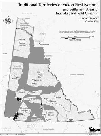
Because treaties are generally taken to be “agreement[s] between two or more fully sovereign and recognized states operating in an international forum, negotiated by officially designated commissioners and ratified by the signatory powers” (Prucha Reference Prucha1994: 2), the treaty-making process necessarily projects onto First Nation societies very particular assumptions about the kinds of political entities they must be to participate in the process at all. Just by framing their arguments in terms of “sovereignty” and “self-government,” northern First Nation people have had to accept—in practice if not in theory—a host of Euro-American assumptions about power and governance that are implicit in such terms. In this article, I focus on a central premise of the sovereignty concept: territorial jurisdiction. As we shall see, jurisdiction, a government's ability to exercise power and authority within its territory, is a fundamental aspect of the sovereignty concept. That is, sovereign power is fundamentally territorial, a fact that informs commonsense notions of the world as divided up among political entities, each exercising jurisdiction over discrete mutually exclusive territories separated by linear borders (Malkki Reference Malkki1992; Murphy Reference Murphy, Biersteker and Weber1996). Such a vision of political space implies that to qualify as a government in the first place, a political entity must have jurisdiction over a clearly defined territory. This vision plainly informs the Yukon agreements, which carve the Yukon into fourteen distinct First Nation “traditional territories” (see map 1).
Yukon First Nation Traditional Territories.

Although many people—First Nation and Euro-Canadian alike—assume that these traditional territories reflect “traditional” patterns of land-use and occupancy, indigenous society in the Yukon was not in fact composed of distinct political entities each with jurisdiction over its own territory; such entities are a quite recent phenomenon in the Yukon. Land claim and self-government agreements are not simply formalizing jurisdictional boundaries among pre-existing First Nation polities; they are mechanisms for creating the legal and administrative systems that bring those polities into being. In fact, the agreements, conceived and written as they are in the language of state sovereignty, are premised on the assumption that First Nation governments must be discrete politico-territorial entities if they are to qualify as governments at all.
Thus, although the Yukon agreements do grant First Nations some very real powers of governance, those powers come in the peculiarly territorial currency of the modern state. Not only does this implicitly devalue aboriginal forms of socio-political organization, it is also helping transform First Nation society in radical and often unintended ways. One of the most significant aspects of this transformation is the emergence among Yukon First Nation peoples of multiple ethno-territorial identities and corresponding nationalist sentiments. To examine this process, I focus on two specific cases of contemporary boundary making among Yukon First Nations. Before doing so, it is necessary to say a bit more about the territorial assumptions that underlie the Yukon agreements.
TERRITORIALITY AND THE STATE
The Territorial State
Over the past two decades, political geographers, anthropologists, and others have analyzed the territorial dimensions of the modern state. Rather than simply taking for granted its territorial boundedness, as scholars did previously, they have begun systematically examining the role of territory—and of territoriality itself—in the constitution of the state as a particular socio-historical phenomenon. Geographer Robert Sack defined territoriality as “the attempt by an individual or group to affect, influence, or control people, phenomena, and relationships, by delimiting and asserting control over a geographic area” (1986: 19). Sack concedes that while there are many other, non-territorial ways of exercising power, “territoriality is the primary spatial form power takes” (ibid.: 26). Territoriality is thus a particular kind of political strategy, one that focuses on controlling people and processes through the demarcation and control of space.Footnote 3
Building on this political conception of territoriality, contemporary political geographers now agree that modern state power is largely—though by no means exclusively—an exercise in territoriality; that is, states seek to control people and resources principally through the demarcation and control of space.Footnote 4 Indeed, the demarcation and control over territory, within which the state supposedly exercises exclusive sovereign power, has long been viewed as an essential aspect of the modern state. Max Weber's famous definition of the state as “a human community that (successfully) claims a monopoly of the legitimate use of physical force within a given territory” (Reference Weber, Gerth and Mills1946: 78), for example, recognizes its fundamentally territorial character. More recently, Anthony Giddens reformulated Weber's definition in even more explicitly territorial terms. For him, the state is “a political organization whose rule is territorially ordered and which is able to mobilize the means of violence to sustain that rule” (1981: 20). The establishment and maintenance of clear boundaries both among and within states is essential to the concept of the modern state and to the exercise of state power. Though specific boundaries, both external and internal, may change over time, the idea that such boundaries exist is so fundamental to the state form that it is generally taken completely for granted.Footnote 5 Political geographers now view territoriality as such an intrinsic aspect of the modern state that many have taken to referring to it as the “territorial state” to distinguish it from other kinds of historical states (Agnew Reference Agnew1994; Reference Agnew2005).Footnote 6
The boundaries of the territorial state delimit, at least in theory, the spatial extent of its legal and administrative jurisdiction, its authority to levy taxes, and the extent of its control over people and resources. In recent decades, though, scholars from across a range of disciplines (e.g., Agnew Reference Agnew2005; Appadurai Reference Appadurai, Low and Lawrence-Zúñiga2003; Raustiala Reference Raustiala2009) have argued that the link between state territory and state power, or sovereignty, is not nearly so clear-cut in practice. Although territorial sovereignty is the ideal basis for state power and perceptions of its legitimacy (Murphy Reference Murphy, Biersteker and Weber1996), the exercise of that power, like the territorial claims upon which it is based, is always contingent and open to contestation. In the context of indigenous struggles against settler colonialism, however, the distinction between de facto and de jure sovereignty can obscure the cultural hegemony of sovereign territoriality. As suggested above, the territorial state has become virtually the only template available to indigenous peoples seeking a measure of self-determination, even when that template is culturally inappropriate. Thus, because they represent a tacit agreement to play by the rules of the political game as formulated by the colonizer, even those indigenous assertions of sovereign territoriality that are successful in practice can be viewed as part of the legacy of colonial domination.
Internal Territoriality
Following Benedict Anderson (Reference Anderson1991), scholars have pointed out the homogenizing tendencies of the modern state, arguing that its creation entails, at least ideally, the melding of previously distinct populations into a single territorially constituted “imagined community.” Yet, ongoing processes within territorial states at the same time produce administrative differences among citizens and carve the landscape into different geographical sub-units. Sack (Reference Sack1986: 53) observes that the modern state is territorial not only externally (i.e., vis-à-vis other states), but also internally: it produces a hierarchy of nested territories right down to the level of individual factories and households, which are themselves internally territorialized. For, although the creation of a unified state requires the erasure of certain kinds of difference, other kinds of differences among people and places are essential for the practice of governance. Internal boundaries allow for the delegation of authority and the rationalization of jurisdiction among different levels of government, the coordination and delivery of government services, the management of people and resources, and so on.
Internal boundary making of this sort is far from politically neutral. Malcolm Anderson points out that boundaries within states, though “often presented as technical adjustments to promote efficiency of administration, are never independent of changes in power relationships” (1997:107). Indeed, as Vandergeest and Peluso (Reference Vandergeest and Peluso1995) show, processes of internal territorialization have played a key role in efforts to expand and consolidate state control over peoples and resources, particularly, but not exclusively, in colonial and post-colonial contexts. In settler states, such processes have resulted in the (often violent) reworking of indigenous social relations, transforming in fundamental ways how certain kinds of people can relate to one another as well as to the land and resources.
Yet, internal territorialization is not always a top-down process, nor are its socio-political consequences always those intended by state officials. “Like international boundaries,” Anderson asserts, “some sub-state boundaries are the outcome of long historical processes of conflict and adjustment between competing interests” (1997: 106–7). He points out that from a historical perspective the distinction between internal and external boundaries can be quite difficult to maintain, since internal boundaries have a tendency to become external ones and vice versa (ibid.; see also Agnew Reference Agnew1994). Even when created within states for purely administrative purposes, internal boundaries can be constitutive of new, and sometimes oppositional political identities (Anderson Reference Anderson1997: 107).Footnote 7 Geographer Anssi Paasi (Reference Paasi1996: 32–38) refers to this as the “institutionalization of regions,” a process that can lead to the rise of regional identities which, like national identities (which they can become), distinguish an “us” from a “them” along territorial lines. One need only glance at a map of the post-colonial world to see that what were once internal administrative boundaries of empire ended up shaping in fundamental ways the nationalist movements that arose in opposition to imperial rule and the geographical configuration of post-colonial states that resulted from those nationalist struggles.
As we shall see, there is a similar political ambiguity in the territorially ordered political system currently emerging in the Yukon. Rooted as it is in colonial administrative practices, the new configuration of territorially constituted First Nations must be viewed as a legacy of colonial rule, of federal efforts to incorporate Yukon First Nation peoples more firmly into the Canadian state. But at the same time, this territorial system is also the product of First Nation resistance to colonial incorporation, a result of thirty years of struggle and compromise. In other words, the new territorially ordered system must be viewed as both an assertion of territorial sovereignty by Yukon First Nations (and recognition of that sovereignty by Canada) and, simultaneously, as a process of internal territorialization that is creating new territorial units (and identities) within the Canadian state (cf., Bruyneel Reference Bruyneel2007).
TERRITORIALITY IN THE YUKON
Until the middle of the twentieth century, Yukon Indian people were nomadic, covering large distances in the course of their annual subsistence round; and for much of the year they lived in small hunting groups. These groups were extremely flexible; there were no formal rules for membership, and their composition was constantly changing as the result of seasonal and longer-term variations in the availability of resources, social tensions among group members, marriage, long-distance trading, and even the mundane desire for a change of pace. Catharine McClellan characterized nineteenth-century Yukon socio-political organization: “A very sparse population was spread over a vast area, making a loosely linked social network with very few sharply defined linguistic and cultural boundaries.… Cohesive political units did not exist—just widely scattered clusters of living groups whose composition and size changed throughout the year as people moved about in quest of food” (1975: 14). She noted that aboriginal leaders “certainly never had clearly defined judicial or punitive powers over all persons living in a delimited territorial unit” (ibid.: 481). Social relations among Yukon Indian people were ordered by principles of kinship and reciprocity rather than territoriality. People drew on far-flung networks of bilateral kin to travel widely and exploit resources more or less where they pleased.Footnote 8 Although these kinship networks certainly existed in space, they were not defined by—nor did they define—specific territories, in Sack's sense of the term. This is not to say that Yukon First Nation people never used territorial strategies of the sort Sack described. It seems clear, for example, that some important fishing sites were “owned” by particular moieties, the members of which regulated access to them. In practice, though, because the moieties are exogamous, everyone had close relatives from the opposite moiety on whom they could prevail for access (ibid.: 483).Footnote 9
Yukon First Nation people were not organized into distinct “tribes” with control over fixed territories. Nor did tribal categories organize their kinship practices, trade, or political relations. In fact, it is questionable whether they had “tribal” categories at all. In her ethnographic survey of the southern Yukon, McClellan did divide up Yukon Indians geographically on the basis of language and referred to these divisions as “tribes,” but she stressed that this was purely for the convenience of the ethnographer and warned that “it is not the kind of classification which the Indians themselves are likely to stress, or perhaps even recognize.” “Tribe” was a particularly problematic term, she suggested, because “usually it implies a sense of political unity which the Yukon natives … never had” (ibid.: 13).Footnote 10
Yukon First Nation people did, of course, have ways of classifying one another; but they did not regard themselves as divided into distinct territorially organized “peoples.” McClellan sketched the outline of a very complex indigenous system for classifying people that, she maintained, “is highly relative, depending on the particular vantage points in time and space of both the classifier and the classified. Also various modes of classification crosscut each other. Finally, the Yukon Indians prefer to think in terms of selected individuals rather than of total geographically bounded groups” (ibid.: 14).Footnote 11 So, although social and geographic boundaries did exist in the Yukon in aboriginal times, those boundaries did not mark off the territories of distinct political units (McClellan Reference McClellan1992). It seems that Yukon First Nation people did not organize themselves into distinct politico-territorial units until well after European contact.
The Expanding State, Territoriality, and First Nation Land Claims in the Yukon
Although Yukon First Nation political organization did change in response to the fur trade, the pace of change accelerated markedly in the 1940s and 1950s when federal officials began asserting control over the lands and peoples of the Canadian north. To this end, they divided the nomadic indigenous population into distinct administrative “bands,” each with its own elected chief and council. These bands, created under the federal Indian Act, had no relation to any existing political units; rather, they were composed of different families who had in many cases very different patterns of seasonal movement and who had settled—or sometimes had forcibly been settled—in a number of central locations.Footnote 12 The enforced settlement of nomadic populations in easily accessible locations is a strategy that has been used by expanding states the world over; it enables officials to assert control over these peoples and to provide them with government programs and services. The bands themselves, despite having elected chiefs and councils, had little real self-government authority, and acted instead as bureaucratic intermediaries between the federal government and local populations, helping to administer government programs such as the provision of social assistance, medical care, and housing (Coates Reference Coates1991: 233). So the division of the Yukon First Nation population into separate administrative bands had more to do with federal administrative objectives than with any cultural or linguistic factors. As we shall see, the federal government occasionally amalgamated and otherwise reorganized previously distinct bands for purely administrative reasons, principally to streamline and decrease the cost of service delivery.
In contrast to the situation in much of southern Canada and the United States, the Canadian government never negotiated any land cession treaties in the Yukon.Footnote 13 Even so, it claimed to control all lands in the Yukon and maintained the position that Yukon First Nation people had no legal entitlement to the land, except that with which the government had explicitly provided them, of which there was very little.Footnote 14 Yukon Indian people made no unified effort to assert their rights to land until 1973. In that year, Elijah Smith, president and co-founder of the newly formed Yukon Native Brotherhood, a political organization representing status Indians throughout the Yukon, presented the federal government with a document entitled Together Today for Our Children Tomorrow. This was the first comprehensive land claim formally accepted for negotiation by the government of Canada.
Despite this, a Yukon land claim agreement was still a long way off. Negotiations dragged on for twenty years, until, in 1993, representatives of the federal and territorial governments along with the Council for Yukon Indians, the Yukon Native Brotherhood's successor organization, signed the Yukon Umbrella Final Agreement (UFA). This is not in itself a land claim agreement; rather, it is a framework for the negotiation of specific Final Agreements between each of the fourteen individual Yukon First Nations and the federal and territorial governments. It is a complex document of twenty-eight chapters that deal not only with land and financial compensation, but also with heritage, taxation, renewable and non-renewable resources, economic development, and more. The UFA contains many general provisions that apply to the entire Yukon and also identifies the areas in which individual First Nations may negotiate provisions specific to their own needs. Each individual Yukon First Nation was to negotiate its own specific Final Agreement within the framework of the UFA. It is important to recognize that the complex structure of the Yukon agreement was the result of compromise between Yukon First Nations, who were generally wary of a single Yukon-wide agreement, preferring instead multiple agreements that would be more sensitive to local First Nation needs, and the federal government that preferred a Yukon-wide agreement so as to avoid the administrative nightmare of having fourteen completely distinct treaties in the Yukon.
I will discuss here relationships among three First Nations, each of which is in a different position with respect to the land claim process: (1) The Champagne and Aishihik First Nations (CAFN) was one of the first four Yukon First Nations to sign and ratify their land claim and self-government agreements, which came into effect in 1995. The CAFN government, which has been up and running for over fifteen years now, is in the vanguard of self-governing Yukon First Nations. (2) The Kluane First Nation (KFN) negotiated its final and self-government agreements in the period from 1995 to 2002. These were signed and ratified in 2003 and came into effect on 1 February 2004. As a result, KFN is still in the relatively early stdialects (Mc of setting up its structures of self-government. (3) The White River First Nation (WRFN) was engaged in negotiations during the same period as KFN, but its leadership refused to bring the agreement-in-principle (initialed in 2002) before the WRFN membership for a ratification vote. As a result, it has no land claim or self-government agreements and its members—unlike those of self-governing Yukon First Nations like CAFN and KFN—are still subject to the provisions of the federal Indian Act.
Territorial Dimensions of the Yukon Land Claim Agreements
With the signing of land claim and self-government agreements, self-governing First Nations have replaced Indian Act bands throughout much of the territory. Although the transformation from band to First Nation has led to some important changes in their demographic composition, there is a great deal of continuity between these new self-governing First Nations and their Indian Act predecessors. To some extent, this was probably inevitable. As we saw, First Nation people were loath to enter into a Yukon-wide agreement, preferring instead a series of individual First Nation Final Agreements that would allow them to address local issues and concerns. Since popularly elected band governments already existed throughout the territory when land claims negotiations began in the 1970s, they naturally played an important role in the political organization of Yukon Indian people. It was individual bands that entered into negotiations with the federal and territorial governments and ultimately became signatories to the Agreements. In fact, people regularly referred to “Band Final Agreements” (rather than the official “First Nation Final Agreements”) through the mid-1990s.
The political continuity between Indian Act bands and self-governing First Nations is also evident in the fact that First Nations inherited responsibility for the delivery of programs and services that had previously been administered by bands (and, in fact, funding levels for First Nation self-government were based directly on the bands' historical spending levels). Although First Nations have also assumed responsibility for additional programs and services that were not administered by bands, there is nevertheless an important sense in which self-governing First Nations evolved from the Indian Act bands that preceded them. The current configuration of First Nations in the Yukon, then, reflects quite closely the legacy of the Department of Indian Affairs' administration of Indian people in the territory.
There is, however, one very important difference between Indian Act bands and the self-governing First Nations that are succeeding them. Unlike bands, First Nations are all associated with bounded geographical areas, known as “traditional territories.” Traditional territories are defined and mapped in the land claim agreements, and they are essential to the structure of both final and self-government agreements in the Yukon. First Nations do not “own” their traditional territories; rather, the traditional territory of each is that region within which it has a recognized role in the management of wildlife, heritage, and other resources, primarily through co-management boards and councils created for this purpose. It is also the region within which that First Nation's citizens have hunting rights and special opportunities for employment and other forms of economic development.Footnote 15
The federal and Yukon governments did not play a major role in the original creation of First Nation traditional territories; instead, they left it up to the bands to work out their future boundaries among themselves, presumably based on patterns of historic land use. Several officials (both federal and territorial) told me their governments had been loath to get involved in disputes over territory among the different bands. Yet, as we have seen, administrative bands were themselves recent and fairly arbitrary amalgamations of different families and individuals, each with their own historically distinct patterns of land use and residency. In some cases, members of the same immediate family—with very similar land-use practices—became members of different administrative bands. Intermarriage among members of different bands was also common. These factors, along with increased individual mobility, made extremely problematic any attempt to map a band's traditional territory based on the historical use and occupancy of its members and their ancestors.Footnote 16 Different First Nations seem to have pursued different strategies when confronted with the task of mapping their traditional territories. Some took an inclusive approach, drawing their boundaries as widely as possible to capture the historic land use of all their members; others were more conservative, giving up their claim to certain areas in an apparent effort to minimize potential overlap with other First Nations. The amalgamated Kluane Tribal Council (discussed below) took the latter approach, since a number of areas used by its members and/or their ancestors now fall well outside their traditional territory.Footnote 17
There are two direct results of this ad hoc process for drawing up First Nation traditional territory boundaries. First, there is a great deal of overlap among First Nation traditional territories in the Yukon (see map 2). Some First Nations are in a situation where well over half their traditional territories overlap with those of their neighbors. Second, some First Nation people feel that they have been cheated since they have lost all say in the management of certain areas of special importance to them personally. Today, the question of traditional territory boundaries is quite contentious in some parts of the Yukon.
First Nation Traditional Territory Overlap in the Yukon. Shading denotes overlap; cross-hatching indicates areas not included in any First Nation traditional territory (author's map).

Although the federal and Yukon territorial governments played a minimal role in the creation of traditional territory boundaries per se, they have generally been adamant about the need to minimize and even eliminate overlap. Because traditional territories are essentially administrative boundaries that determine the jurisdiction of various management boards and councils set up under the land claim agreements, any territorial overlap necessarily creates jurisdictional conflict. In anticipation of this problem, First Nation Final Agreements require First Nations to “resolve” any overlap by negotiating an “Overlap Resolution Boundary,” a contiguous line that in effect eliminates the conflict by specifying where one board's jurisdiction begins and another's ends (e.g., Kluane First Nation 2003: 37). Until overlap is resolved in this way, overlap areas exist in a jurisdictional void, and a number of very important provisions of the Final Agreements do not apply within them. So, for example, Renewable Resources Councils, those co-management bodies established under the agreements as “principal instrument[s] for renewable resource management” throughout a First Nation's traditional territory (ibid.: 241), have no jurisdiction at all in overlap areas. Although this does prevent jurisdictional conflicts between Renewable Resources Councils, it also means that First Nation people have virtually no say over the management of fish, wildlife, and timber in overlap areas (except on settlement lands).Footnote 18
In theory, overlap resolution boundaries would be used only to establish the jurisdiction of a few co-management boards and to bring a handful of other provisions (mostly regarding economic development) into effect in the overlap areas. For most other things, most importantly the exercise of hunting rights, the First Nations could continue to “share” the overlap areas (i.e., citizens of both First Nations could hunt there). In fact, there has been some interest in and activity around the negotiation of “sharing accords.” These are reciprocal agreements among First Nations that go beyond the shared use of overlap areas by extending to one another's citizens certain rights, particularly hunting rights, throughout the signatory First Nations' entire traditional territories.Footnote 19 In practice, however, the negotiation of overlap resolution boundaries has often been contentious and difficult. This is not surprising, since it requires First Nation people to do something they have never done before: construct firm political boundaries between themselves and their neighbors (who are, often enough, close kin). The notion of a contiguous line separating “us” from “them” flies in the face of important cultural values of kinship and reciprocity, which continue to structure social relations among First Nations people (Nadasdy Reference Nadasdy2003: ch. 2; see also Easton Reference Easton2007; Thom Reference Thom2009).
Technically, First Nations could continue to share most everything in the overlap area, since an overlap resolution boundary applies only to certain jurisdictional issues, but in my experience this is often poorly understood. The very term “traditional territory,” with its invocation of “tradition,” seems to imply a link to historical use and occupancy, and First Nation people (along with government negotiators) by and large think of them in this way. Yet, any well-defined territorial boundary between First Nations must necessarily be crosscut by kinship relations and inconsistent with historical and contemporary patterns of use and occupancy. What is more, in the minds of many First Nation people traditional territories have come to be emblematic of self-governing First Nations' history and sovereignty.Footnote 20 As a result, there is often great reluctance to “give up” land to neighboring First Nations through the “resolution” of overlap, because to many this seems tantamount to denying their affective ties to the land derived from historical and contemporary use. This is precisely what happened in failed efforts to resolve overlap between the Kluane and White River First Nation territories.
CASE STUDY 1: TERRITORIAL OVERLAP BETWEEN THE KLUANE AND WHITE RIVER FIRST NATIONS
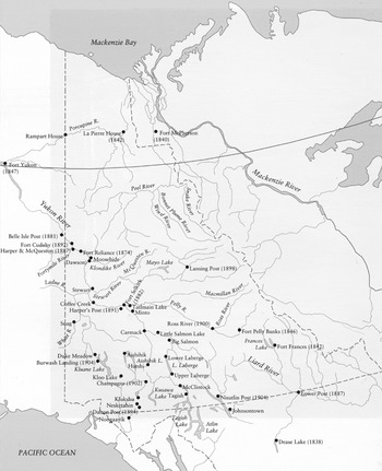
The White River Band, composed of Upper Tanana and Northern Tutchone speakers and based in the present-day village of Beaver Creek, was actually created by the government through the amalgamation of the distinct Snag and Stewart River Bands in 1956 (see map 3). Further to the south, the government created the Burwash Band, based in the village of Burwash Landing. Then, in 1961, in the interests of economy and efficiency of administration, the federal government amalgamated the distinct White River and Burwash bands (Nadasdy Reference Nadasdy2003: 48–49). It created in their place the Kluane Band, which subsequently was renamed the Kluane Tribal Council. This amalgamation led to the relocation of most White River people from the village of Beaver Creek to Burwash Landing, which caused hard feelings and tensions that persist to this day. In 1990, the Kluane Tribal Council, amidst a great deal of acrimony, separated again into the distinct Kluane and White River First Nations, and WRFN subsequently filed a wrongful amalgamation suit against the federal government.
Some Early Yukon Trading Posts and Camps. Map from the book Dän Dhé Ts'edenintth'é Reading Voices: Oral and Written Interpretations of the Yukon's Past, © 1991 by Julie Cruikshank, published by Douglas & McIntyre: an imprint of D&M Publishers Inc. Reprinted with permission from the publisher and author.

This final split did not occur, however, until after the amalgamated Kluane Tribal Council had already established its traditional territory under the Yukon Umbrella Final Agreement.Footnote 21 In a relatively last-minute scramble to adjust this Agreement to reflect the new situation, negotiators divided the land quantum and compensation money that had been earmarked for the amalgamated Kluane Tribal Council and reallocated it on a per capita basis to the once again distinct White River and Kluane First Nations. Negotiators also included a provision (UFA 2.9.1) requiring the KFN and WRFN to submit amended traditional territory maps prior to its ratification (Kluane First Nation 2003: 21). For reasons that will become clear, this never occurred. As a result, KFN and WRFN are currently in the unique position of having identical traditional territories (or, in the parlance of Yukon land claims, 100 percent overlap). This situation has caused considerable tension and has profound implications for the final and self-government agreements of both First Nations, since, as we have seen, significant parts of those agreements—especially those related to the management of fish and wildlife—do not apply in overlap areas. As a result, both First Nations have put considerable effort into trying to resolve their overlap. Yet after twenty years of trying, they have failed to do so.
At one meeting in 1995, elders from both First Nations met to discuss the overlap issue. After two days of talks, they unanimously agreed to share the traditional territory, in effect refusing to draw a line resolving the overlap. Central to their discussions was the notion that a boundary was incompatible with their cultural values; they had always shared the land and intended to continue doing so. As Bessie John, a respected White River elder, put it:
We are one nation to this country where we was born! That's what they should tell the government, I say. Where is our mother? There was one that came from the ground to this earth here. And government people they think they're our bosses. We should be boss of our country. One trail from all the way to Alaska. All the way down from Alaska to that river there. I talk about that river, that Yukon River, belong to Indian for Earth. God, who made that river for Indian food. That's our food, that river. No one made for us, only Earth and God can make for us our food. Government should know that.… Every day I stay home I was thinking. We should share the land with each other. We are one First Nation. We are Indian on our land. We should share our land now, together.Footnote 22
Another elder who attended those talks told me she had had ambivalent feelings about them, so she had consulted her own mother, who had been too old to attend. She asked her which areas White River people had used and which Kluane people. She told me that for a long time her mother had not even understood what she was trying to ask, and that when she finally did understand she became angry, saying only that White River and Kluane people had always shared the land (see also Easton Reference Easton2001). Many elders at the meeting explicitly attributed the purported need for a boundary to a divide-and-conquer strategy on the part of government, and many talked about the need to reject any talk about a contiguous line for this reason.Footnote 23 In fact, a common theme in all of the overlap talks I examined—from 1990, 1995, and 2002—was that it was the government that had imposed the need for a line, and that if it were left up to the First Nations they would just continue to share the land.Footnote 24
When I discussed this with a federal negotiator, he disagreed with that characterization of the government position. He acknowledged that neither he nor other officials were qualified to make judgments on traditional use, so they had intentionally left the process of overlap resolution to the First Nations; government played only a facilitating role (e.g., they had paid for a moderator in the 2002 talks between KFN and WRFN). In fact, he told me, in the final overlap talks that took place in the spring and summer of 2002, Canada and the Yukon had been open to any solution that would have permitted Kluane and White River to finalize their agreements. At the time, he said, a number of the First Nation people at the table had suggested that there be no boundary line at all, that Kluane and White River should just share the entire traditional territory. He said that both Canada and the Yukon had been open to this approach, but that in the end it had been the First Nations people themselves who had rejected it.
When I later discussed this negotiator's comments with one of KFN's negotiators, she acknowledged that what he had told me was technically true; Canada and the Yukon had been willing to go with whatever the First Nations decided, even if that meant refusing to draw a line at all. She pointed out, however, that such a solution would have required one of two things: either the renegotiation of both First Nation final agreements to deal with the intractable jurisdictional issues that would arise from 100 percent overlap—essentially a completely different kind of agreement—or else the re-amalgamation of Kluane and White River First Nations. Practically speaking, the first option was out of the question. The federal negotiating mandate was set to expire, memoranda of understanding had already been signed committing the parties to take the existing deals to ratification, and federal funding for negotiations had just about come to an end. This left re-amalgamation the only viable option. Legally speaking, this seems the more straightforward of the two options, although in practice it, too, would have required a renegotiation, since it would have meant combining two different agreements into one. Re-amalgamation also seems consistent with the First Nation preference for sharing the land. Politically, however, this option was out of the question, because the wrongful amalgamation of the White River and Kluane bands in 1961 has since become for First Nation people of the region one of the most salient symbols of the history of their oppression at the hands of the federal government. They had spent years fighting to be allowed to separate, so that White River people could return to their homes on the Alaska/Yukon borderland, and the split when it finally came was messy. In talking to me about the split with White River, several KFN citizens likened it to a divorce; there was fighting over who would get the property (i.e., band assets), which led to bitterness that is still palpable. To imagine that re-amalgamation was a viable solution is to completely ignore the region's colonial history. This same KFN negotiator added that at the 2002 meeting even those elders who advocated sharing the entire territory ultimately balked when she pointed out that it would mean re-amalgamation.
In this light, it is noteworthy that at the 1995 elders meeting mentioned earlier (at which the elders unanimously agreed to share the land) there was no discussion whatsoever of what an overlap resolution boundary actually is or its relation to the final agreements. Instead, they talked about who had historically used what land and when. It is no surprise, then, that the elders ultimately decided to share the land and allow members of both First Nations to continue to hunt anywhere within the traditional territory. Recall, though, that they came to this decision in spite of the lingering bitterness over the 1990 split. This illustrates, I think, the power and ongoing importance of the belief among Yukon First Nation people that the land and animals should be shared, a legacy from the time before the existence of territorially ordered First Nation polities. It is important that the elders at this meeting never discussed the implications of their decision for their land claims agreements. This is probably because the negotiators, who were familiar with the legal context of the discussions and might have called attention to these implications, were not present.
Thus, the government negotiator's assertion that it was essentially up to the First Nations whether or not they wanted a contiguous line is only accurate if one ignores the legal and historical contexts in which the overlap discussions took place. This is not to say that the need for a contiguous line was part of a conscious government plot to divide and conquer, as some First Nation people believed. Rather, it reflects the territorial structure and associated jurisdictional and administrative arrangements of the land claims agreements themselves.
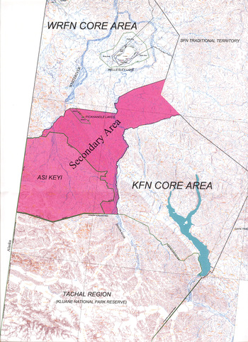
The issue of overlap came to a head in 2002–2003 as KFN's negotiations neared completion. (Recall that WRFN had not signed an agreement and seemed unlikely to do so.) Without an overlap resolution boundary, 100 percent overlap meant that important provisions of KFN's agreement would not come into effect at all. For example, the Renewable Resources Council for their traditional territory would have no jurisdiction anywhere. When it became clear that the First Nations would not reach a mutually agreeable solution, KFN, along with the federal and Yukon territorial governments, came up with a solution that would allow those provisions of their agreement to come into effect in at least part of their traditional territory (see map 4). They divided the overlapped territory into three sections: a WRFN Core Area, a KFN Core Area, and a shared Secondary Area between them. Each First Nation would enjoy exclusive jurisdiction in its Core Area and only limited shared jurisdiction in the Secondary Area. This solution allows KFN to exercise jurisdiction in at least part of its traditional territory, but the solution is only provisional, and possibly illegal. It is subject to change depending on the terms of any future WRFN Final Agreement, any overlap resolution boundary the two First Nations might negotiate in the future, and/or a successful court challenge (and WRFN threatened at one point to mount one). In the end, this solution, creative as it is, is still based on a clear demarcation of the two First Nations' (core area) boundaries.
Core and Secondary Territories as Defined in KFN's Final Agreement.

One of the most important changes associated with the territorial ordering of First Nation political space is the emergence among Yukon First Nation peoples of multiple ethno-territorial identities, and corresponding nationalist sentiments. Geographer Adam Moore usefully defines ethno-territoriality as “a political project the goal of which is to establish an explicitly spatial basis for various ethnic claims—such as identity, cultural rights, autonomy, etc.—by constructing territories belonging to or appropriate for certain ethnic categories of people and practice…” (Reference Moore2010: 20). He observes that ethnic/national categories are themselves often created, or given new significance, by ethno-territorial strategies, which can cause “others to be ‘imagined’ as members of the same cultural and political community based upon a shared relationship to a specific territory” (ibid.: 38). This suggests that the process of internal territorialization currently taking place in the Yukon is dialectically linked to the emergence of new First Nation ethnic/national identities.
SOVEREIGN TERRITORIALITY AND THE RISE OF FIRST NATION NATIONALISM
We have made Italy, now we have to make Italians.
———Massimo d'Azeglio, quoted in Hobsbawm (Reference Hobsbawm1992: 44)Among the many consequences of territoriality identified by Sack is that “territoriality acts as a container or mold for the spatial properties of events” (1986: 33). This aptly characterizes the territorial state, which Giddens has famously described as “a power-container whose administrative purview corresponds exactly to its territorial delimitation” (1981: 172).Footnote 25 As many scholars (e.g., Anderson Reference Anderson1991; Giddens Reference Giddens1981) have noted, the administrative power of the state depends in large part on its ability to gather and manipulate statistical and geographical information about the populations and resources within its borders (e.g., censuses, maps, economic indicators). The rise of the territorial state was accompanied by the emergence of a vast machinery for the production of these official data, and it was the state itself, as container, that provided the spatial unit for their collection and analysis (Murphy Reference Murphy, Biersteker and Weber1996: 102–3). Because the emerging social sciences relied heavily upon official data generated by the state, and, indeed, were intimately involved in their production, and because the assumptions underlying those data, territorial and otherwise, informed the operational categories of the new social science disciplines, they tended to regard the boundaries of “society” as congruent with those of the state (Agnew Reference Agnew1994: 69–70; Smith Reference Smith1979: 191; Wolf Reference Wolf1982: 7–19). These official data, then, are not just “about” the state as a pre-existing social entity, they are also in part constitutive of it and of the particular notion of society it engenders and contains (Giddens Reference Giddens1981: 180).
Maps have played a particularly important role in this process. In his study of the birth of the Thai nation, Thongchai Winichakul argues that early government-generated maps of the country were not simply abstract representations of reality. The situation was rather the reverse: “A map anticipated spatial reality, not vice versa. In other words, a map was a model for, rather than a model of, what it purported to represent.” In particular, he shows how maps served as models for the construction of Siam as a modern territorial state: “All the requisites of a map of a nation had not been given in pre-modern Siam and thus had to be created to meet the demands of a map … the regime of mapping did not passively reflect Siam. Rather, it has actively structured ‘Siam’ in our minds as well as on earth” (1994: 130). In particular, maps were essential for developing the Thai state's administrative and military mechanisms.Footnote 26 Ultimately, Thongchai argues, these maps, along with all the political and administrative structures they envisioned and facilitated, helped bring about the rise of the Thai nation, an imagined community whose “geo-body” was inscribed on those maps.
If the state is a container for society, then the borders of the state must separate members of distinct societies; that is, they serve to divide an “us” from a “them.” It is this tendency to assume that the borders of the state separate distinct peoples—along with all the data-gathering activities entailed in such an assumption—that Anthony Smith has referred to as “methodological nationalism” (1979: 191). The territorially bounded institutions, knowledge, and practices associated with the state can play an important role in creating the imagined political-economic community that is a nation. Scholars have argued persuasively that the emergence of the territorial state system preceded and contributed to the rise of nationalism, and not the other way around (Hobsbawm Reference Hobsbawm1992: 78; Murphy Reference Murphy, Biersteker and Weber1996: 95).Footnote 27
Nationalism is fundamentally a territorial ideology, one that is intimately and dialectically bound up with the territoriality of the state system. Geographer Edward Soja puts it succinctly: “The nation-state is probably the most territorial of human political organizations. Its basic ideological force—nationalism—is, in essence, the drive by a particular group for a state—a territory—of its own” (Reference Soja1971: 16).Footnote 28 So intimate is the link between territorial state and nation that there is a widespread tendency to conflate the two concepts (often lamented by scholars of nationalism). Indeed, the very term “nation-state” assumes that the state and the nation are conterminous, an ideal that has rarely if ever been achieved. Yet this tendency to conflate state and nation is not simply the result of sloppy word choice; it reflects the nationalist ideal, an ideal that animates the nation-building visions of state politicians as much as it does the state-building dreams of ethno-nationalist separatists (Gellner Reference Gellner1983: 1).
Benedict Anderson has written, “The nineteenth century colonial state (and policies that its mindset encouraged) dialectically engendered the grammar of the nationalisms that eventually arose to combat it” (1991: xiv). A key aspect of this grammar was, and remains, ethno-territoriality. For a case in point, scholars of ethnogenesis in many parts of indigenous North and South America have viewed the emergence of relatively distinct ethnicities/nations/tribes associated with fixed territories as largely the product of colonial interactions (Hill Reference Hill1996; Sider Reference Sider1994; Sturtevant Reference Sturtevant, Leacock and Lurie1971). For example, Patricia Albers, in her account of ethnogenetic processes among the Assiniboin, Cree, and Ojibwe of the northern plains, argues,
Ethnicity in the generic and highly abstract sense of a ‘tribal’ name did not always function as a marker of geopolitical boundaries. Given a pluralistic pattern of land use and alliance making, most of their ethnic categories did not have a high level of salience or any a priori power to organize and distribute people across geographic space.… it was only after the imposition of US and Canadian sovereignty that their ethnic names took on any real importance, and then it was only because these were invested with the legal power of treaties written by nation-states (Reference Albers and Hill1996: 91).
Similarly, the drawing of traditional territory boundaries between Yukon First Nations was initially devoid of social meaning for most Yukon First Nation people. Over time, however, this has begun to change. Like Thongchai's maps of Siam, the maps attached to the Yukon land claim agreements were created as models for a new, territorially ordered form of governance, as mechanisms for the creation of a particular system of legal, administrative, and jurisdictional relations. To the extent that they now undergird a whole complex system of political and legal relations, First Nation traditional territorial boundaries have gradually assumed significance not only in the realm of aboriginal-state relations, but among First Nation people as well, as is evident in the conflict between KFN and WRFN.
Although enmity and conflict among Yukon First Nation people is certainly nothing new,Footnote 29 what is new is the way in which such conflict has become territorialized. Whereas in the past Yukon Indian people drew on relations of kinship, reciprocity, and co-residence to enlist allies in their conflicts with one another (with the consequence that one could generally find both allies and enemies in any camp), today Yukon First Nation people are increasingly likely to view conflict as taking place between ethno-territorial entities, such as KFN and WRFN. And indeed, as a result of amalgamation and the legacy of conflict it engendered, many First Nation people now distinguish clearly—at least in some contexts—not only between Kluane and White River territories, but also between Kluane and White River people, a distinction that would have made little sense to their grandparents (which is why elders insisted on sharing the land).Footnote 30 KFN and WRFN have thus increasingly become the repositories of ethno-territorial sentiments and loyalties that crosscut, and sometimes now override relations of kinship and reciprocity.Footnote 31
The conflict between KFN and WRFN predates the finalization of Yukon agreements and the territorial order they helped to create. Yet the conflict clearly has its roots in the colonial history of the region and derives its shape from the territorializing nature of those agreements, the negotiation of which had profound effects on First Nation society long before they were ever signed and ratified (Nadasdy Reference Nadasdy2003: ch. 6). To understand the role played by the agreements themselves in the emergence of ethno-territorial distinctions among Yukon First Nations, it is useful to examine the relationship between KFN and its neighbor to the south: the Champagne and Aishihik First Nations (CAFN).
CASE STUDY 2: KFN, CAFN, AND THE RISE OF NATIONALIST SENTIMENT
Relations between the KFN and CAFN are friendly. There is not much overlap between their traditional territories (see map 1), and efforts to resolve the little there is have been relatively amicable. There is also considerable day-to-day social interaction between Kluane and Champagne/Aishihik citizens, nearly all of whom have very close relatives (e.g., spouses, parents, children, siblings, or cousins) in the other First Nation.
That is why I was surprised in the summer of 2006 when Joe Johnson, a citizen of KFN and a good friend, told me he had obtained a Yukon hunting license so he could hunt around Fourth of July Creek, just across the KFN-CAFN border. Under the terms of KFN's Final Agreement, Kluane citizens are free to hunt anywhere in their own traditional territory without a Yukon hunting license. To hunt within another First Nation's territory, however, they have a choice: they can either get permission to hunt there from that First Nation, or they can obtain a Yukon hunting license in the same fashion as any non-First Nation Yukon resident. Those First Nation citizens who choose the latter strategy are subject to Yukon—rather than First Nation—hunting regulations.Footnote 32 That Joe would have done the latter frankly stunned me. In practical terms, it is not much more difficult for a Kluane citizen to obtain a Yukon hunting license than to get permission to hunt from another First Nation, but to do so is to submit to the authority of the Yukon Fish and Wildlife Branch.
As I have detailed elsewhere (2003: 38–41), fish and game laws were among the principle mechanisms used by federal and territorial officials to establish and maintain control over Yukon Indian people, beginning in the 1940s. The consequences of this were particularly dire for First Nation people in the southwest Yukon where the creation of the Kluane Game Sanctuary (later Kluane National Park) threatened their very survival; on at least one occasion, the government had to truck beef into the region to prevent starvation. Fish and game laws also undermined important cultural practices; years before, Joe himself had risked imprisonment by “illegally” hunting Dall sheep for his father's funeral potlatch, without which, he felt, it would have been impossible to carry out a proper ceremony.Footnote 33 Indeed, opposition to Yukon fish and game laws was one of the prime factors that motivated Yukon Indian people to organize politically and push for the settlement of land claims in the 1970s. They had been staunch defenders of what they saw as their aboriginal hunting rights and would never have agreed to a treaty that subjected them to Yukon hunting regulations (ibid.: 55). Hence my surprise when I learned about Joe's choice to obtain a Yukon hunting license rather than go through the CAFN fish and wildlife office.
When I asked Joe why he had done so, he explained that the summer before, the last time he and I had hunted together up Fourth of July Creek, he had asked CAFN for permission to hunt. In response, they sent him a letter granting him permission to hunt there for one specific week only. After telling me this, he looked at me for a while, his eyes smoldering. Then he went on to say that if a CAFN citizen asks for permission to hunt in Kluane territory, “we give them as much time as they want.” He said he had decided to get a Yukon license so he could hunt wherever he wanted and would not have to put up with such insulting treatment anymore. The language of “us and them” that Joe used is, I think, significant. Some of his closest relatives were citizens of CAFN, including his paternal uncles who helped raise him and taught him to hunt. Yet, because of the territorial boundary and the regulatory regime it engenders, it had become possible for him to draw a distinction between “us”—Kluane people—and them—Champagne and Aishihik peopleFootnote 34—in a manner that would have been unthinkable just two decades earlier.
Two decades ago, it would also have been unthinkable for a Yukon First Nation person to deny or limit another's right to hunt anywhere he or she wanted. In light of the continuing cultural and economic importance of First Nation hunting in the Yukon and the colonial legacy of wildlife management in the territory, it is hard even now to imagine one First Nation person denying another's right to hunt. In the case of Joe's application to CAFN the previous year, wildlife officials were able to restrict his ability to hunt in the way they did only because of the prior creation of a bureaucratic apparatus for managing fish and wildlife, a development that was itself wholly dependent upon the creation of jurisdictional boundaries between the two First Nations. As noted above, CAFN's agreements have been in place since 1995, so in 2006 they were much further along in the process of establishing their own government institutions than was KFN, which had been self-governing only since 2004. CAFN had by then established a Fish and Wildlife office to manage the lands over which they have jurisdiction and had set up a formal permitting process to deal with requests like Joe's. As a result, the limitation on Joe's ability to hunt was issued not by a specific person, but by the First Nation's bureaucratic apparatus. Thus, Joe's anger was directed not at a particular person acting in a culturally inappropriate manner, but at “them”—CAFN as an ethno-territorial whole.
Joe's impression that KFN regularly and routinely granted citizens from other First Nations permission to hunt in their territory was rooted in his many years of experience in the KFN office where he served in various capacities, including several terms as chief, until his retirement in 1996. During those years, KFN dealt with requests for permission to hunt in an informal, ad hoc, and personalized manner. From my own observations in the KFN office between 1995 and 2003 I, too, got the impression that KFN always granted such requests from citizens of other First Nations; the issuance of letters of permission—mostly to CAFN hunters—had seemed to me little more than a formality. But things began to change after KFN's agreement came into effect on 2 February 2004. On 15 April of that year, the director of KFN's Fish and Wildlife department told me that CAFN citizens were regularly calling the office for permission to hunt in KFN territory. Since the newly self-governing KFN as yet had no policy in place for dealing with these requests, she said, she had no choice but to deny them permission. She admitted this was a difficult situation, because many of them got quite angry when she told them they could not hunt. She said she hoped KFN and CAFN would soon sign a sharing accord to deal with the problem. In fact, KFN and CAFN, along with the Ta'an Kwäch'än Council (the third member of the Southern Tutchone Tribal Council), had signed a sharing accord in 1997, but KFN had never ratified it because of concerns about whether they had the legal authority to do so given their 100 percent overlap with WRFN. As I have explained, the legal implications of the overlap issue did not disappear when KFN became self-governing, and one result was that there was still no sharing accord in place in 2006 when Joe Johnson wanted to hunt on Fourth of July Creek.
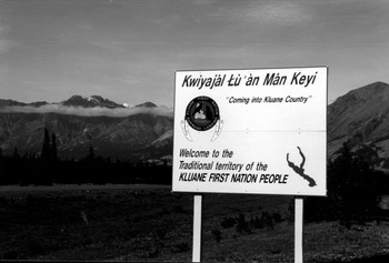
Overlap with WRFN was not the only obstacle to formalizing reciprocal hunting rights between CAFN and KFN citizens. By 2006 there was a growing concern, especially among some younger KFN citizens, about possible over-hunting of moose in KFN's territory owing to encroachment by CAFN citizens. Several of them independently expressed to me their concerns about the number of CAFN citizens who had recently been hunting in the Donjek River valley, deep in Kluane territory. One man—the same, incidentally, who orchestrated the raising of signs on the Alaska Highway to mark the boundaries of Kluane territory (see figure 1)—told me it was imperative that KFN get its government up and running as soon as possible so that Kluane people could control hunting by citizens of other First Nations and thereby protect their animal populations. The implication of his statement was clear: without a bureaucratic screen of laws and regulatory processes in place, it would remain very difficult for any KFN citizen to deny—or provide only limited approval to—requests by citizens of other First Nations to hunt in Kluane territory.Footnote 35
Entering Kluane First Nation Territory (author's photo).

It is becoming ever more common to hear First Nation people invoke language of “us” and “them” to assert their First Nation's exclusive rights to control the resources within its territorial boundaries. Ethno-territorial sentiments of this sort do not always take precedence over crosscutting relations of kinship and reciprocity,Footnote 36 and in fact these non-territorial social relations remain strong and provide the basis for a trenchant moral critique of the growing ethno-territoriality and nationalist sentiments. But there can be little doubt that the new maps and boundaries—which as we have seen contradict the explicit desires of many First Nation elders—function as “models for” a powerful new system of legal and administrative relations, a system that is transforming how First Nation people relate to one another and to the land.
CONCLUSION
Land claim and self-government agreements in the Yukon resulted from decades of struggle against colonial policies, and they grant Yukon First Nations significant powers to govern their peoples and resources. Those powers, however, come in the currency of territorial sovereignty, and to wield them Yukon First Nation people have had to alter their forms of social and political organization in dramatic and often unforeseen ways. One of the most important results of these changes has been the rise of ethno-territorial nationalisms among First Nations. Although using the discourse of nationalism and self-determination has enabled Yukon First Nations, like colonized peoples elsewhere, to score important political victories in their struggle against colonial domination, this discourse takes for granted a deeper colonial logic about the modernity of the colonizer and the backwardness of the colonized (Chatterjee Reference Chatterjee1993: 30).
The ethno-territorial assumptions underlying nationalist discourse are so fundamental a premise of contemporary political thought that non-territorial forms of governance are not even recognized as potential alternatives to colonial rule: First Nation self-government must be territorially ordered or it will not qualify as “government” at all. Michael Asch (Reference Asch and Havemann1999) has argued convincingly that the Canadian government's claim to sovereign jurisdiction over Canadian territory is itself rooted firmly in the underlying assumption that contact-era First Nation people were too primitive to have governments. A central challenge for Yukon First Nations in the land claim process has been to convince the federal government that they are capable of self-government (i.e., that they are no longer too “primitive” to govern themselves), and the only permissible evidence of this capacity is the ability to establish and run a European-style territorially ordered government. Kluane negotiators were regularly forced to counter veiled suggestions that they were not yet ready for self-government with assurances that they would indeed develop Euro-Canadian style laws and political institutions (Nadasdy Reference Nadasdy2003: 250–51). This same paternalistic subtext is evident in by now taken-for-granted calls in the Canadian self-government discourse for First Nations to “build capacity,” a euphemism for Euro-Canadian-style training that will enable them to serve as the bureaucratic functionaries increasingly required by land claim and self-government agreements—as if they had not had the “capacity” to govern themselves before the arrival of Euro-Canadians (Irlbacher-Fox Reference Irlbacher-Fox2009). Yukon First Nation negotiators thus found themselves in a grimly ironic position: the only way they could convince federal negotiators that they were politically mature enough to handle “self-government” was to agree to the establishment of a socio-political system that was not their own. In an important sense, then, the Yukon agreements can be viewed as part of an ongoing process of internal territorialization in Canada. Because this process compels First Nation people to adopt Euro-Canadian forms of governance, it serves to extend the colonial project even as the agreements grant newly emerging First Nation polities a measure of power within the state context.