Introduction
Wetlands are transitional areas between terrestrial and aquatic ecosystems that support important functions such as water filtration, flood regulation, drought prevention, pollution control, carbon sequestration and climate regulation (Wan et al. Reference Wan, Zhang, Zhang, Qi and Na2015). Globally, wetlands cover c. 1280 million ha and have undergone a 21–35% reduction from 1700 to 2020 (Das & Mehrotra Reference Das and Mehrotra2023, Fluet-Chouinard et al. Reference Fluet-Chouinard, Stocker, Zhang, Malhotra, Melton and Poulter2023). India possesses only 4% of the global accessible water resources but supports 17% of the global human population (Das & Mehrotra Reference Das and Mehrotra2023). Indian wetlands covering 15.26 million ha have declined by 38–42% since 1970 due to urbanization and agricultural expansion (MoEFCC 2018). Approximately 64% of Indian wetlands have experienced degradation primarily due to intensive agricultural practices, encroachments, deforestation, overgrazing, industrialization, tourism and mining activities (Ahmad et al. Reference Ahmad, Ahmad, Ahmad, Jamal and Saqib2024). Understanding impacts of land-cover change on the spatial characteristics of wetlands in urban areas is essential for conserving existing wetlands.
Remote sensing (RS) and Geographic Information Systems (GIS) have been extensively used in various studies for quantifying changes in Indian wetlands across various domains (Garg Reference Garg2015). They include changes in land cover, landscape patterns, vulnerability, valuation of ecosystem services, hydrology, coastal ecosystems and development of wetland databases (Singh et al. Reference Singh, Bhardwaj and Verma2020, Chopra et al. Reference Chopra, Khuman and Dhyani2022). However, most of these studies largely focus on wetlands located in the lowlands or plains of India, neglecting the distinct hydro-geomorphic dynamics of the high-altitude Himalayan wetlands. Moreover, cities in the Himalayas are ecologically sensitive, with fragile wetlands that are highly vulnerable to environmental changes, climate variability and intensifying urbanization, which accelerate fragmentation and water loss in these high-altitude ecosystems. Furthermore, RS and GIS have been integrated with various machine learning models which include cellular automata (CA), artificial neural network–cellular automata (ANN–CA), constrained CA, patch-based CA, fuzzy CA, multi-CA, weight of evidence (WoE) and land change modelers (LCMs) to predict future land-cover changes in wetland areas (Chettry & Manisha Reference Chettry and Manisha2022, Salas et al. Reference Salas, Kumaran, Bennett, Willis and Mitchell2024). Predicting land-cover changes in rapidly urbanizing Himalayan urban wetlands is crucial for sustainable resource management and informed urban planning. However, few studies explicitly examine the extent to which projected land-cover changes affect landscape pattern metrics in these ecologically fragile areas.
This study investigates urbanization’s impacts on wetlands in a densely populated city within the ecologically sensitive north-western Indian Himalayan region. The wetlands of Srinagar exhibit regional ecological significance within the Kashmir Himalaya through their unique high-altitude characteristics and socio-ecological roles (Dar et al. Reference Dar, Bhat, Rashid and Dar2020). They support 52 migratory bird species (including 18 near-threatened taxa), provide 15–20% of the city’s freshwater supply and regulate local microclimate through a 72% contribution to evapotranspiration (Dar et al. Reference Dar, Bhat, Rashid and Dar2020, Rashid & Aneaus Reference Rashid and Aneaus2020). These wetlands also buffer flood peaks during Jhelum River overflows, which is critical in a region receiving 25–30% of its annual rainfall during single monsoon events, and they maintain groundwater recharge that contributes 8–12% of water to regional aquifers (Meraj et al. Reference Meraj, Romshoo, Yousuf, Altaf and Altaf2015).
In this context, the study hypothesizes that the transformation of land cover driven by urban growth adversely affects the ecological integrity and spatial configuration of Srinagar’s wetlands. To test this hypothesis, this study combines a spatiotemporal land-cover assessment with future landscape predictions using a ANN–AN framework and analyses landscape pattern metrics for both existing and predicted scenarios. It extends previous land-cover change models by integrating a multi-scenario ANN–CA framework with detailed landscape pattern indices in Himalayan urban wetlands, where predictive landscape pattern research remains limited. Furthermore, it explicitly evaluates the effects of projected changes on the spatial configuration and connectivity of wetland landscapes to support informed urban planning and conservation. This approach provides novel, scalable frameworks for managing Himalayan wetlands under urban pressures, aligned with Sustainable Development Goals (SDGs) 6 and 11. Such studies provide targeted insights for managing urban wetlands in high-altitude regions and for formulating policy, particularly addressing land-cover changes driven by increasing tourism pressure, expanding floating gardens and improper waste management in rapidly urbanizing Himalayan cities.
Methods
Study area
Srinagar is the summer capital of Jammu and Kashmir and a major tourist destination due to its picturesque scenery. The Jhelum River divides the city into two parts. The city (33°59ʹ14ʺ–34°12ʹ37ʺN and 74°41ʹ06ʺ–74°57ʹ27ʺE) lies at an elevation of 1580 m above sea level (Fig. 1) and covers an area of 245 km2. The population of Srinagar increased from 0.122 million in 1901 to 1.27 million in 2011 (Zahoor et al. Reference Zahoor, Rao, Hajam, Kumar and Najar2021), and Srinagar is now a major tourist destination in India, attracting 1.25 million tourists in 2024 (NDTV 2024).
Diagrammatic maps of the study area and its location in India.

Land-cover classification, accuracy assessment and prediction
The study utilized Landsat imagery from the years 1991, 2001, 2011 and 2021, which were acquired from the United States Geological Survey’s (USGS) Earth Explorer platform (see details in Table S1 and methodology flowchart in Fig. S1).
Land-cover classification was conducted in ArcGIS 10.3 for the years 1991, 2001, 2011 and 2021 using the Maximum Likelihood Classification (MLC) tool for six land-cover classes: wetlands, river, vegetation, agriculture, fallow land and built-up. Vegetation represents forest cover, woodland and tree cover, while fallow land corresponds to temporarily uncultivated agricultural areas. An accuracy assessment was conducted using a random sampling strategy to validate the land-cover maps using Google Earth Pro. This was achieved by plotting a confusion matrix to obtain the overall accuracy (OA) and kappa coefficient (
 ${\kappa _i}$
), providing insights into the distribution of classification errors among the various land-cover classes. MLC, OA and
 ${\kappa _i}$
are derived using Equations S1–S3.
This study utilized a range of physical and socioeconomic spatial variables to predict land cover. These included elevation, slope, aspect, hill shade and distances to various features such as roads, waterbodies, airports, railways, urban cores, tourist sites and industrial estates, as shown in Fig. S2. A detailed description of all the variables employed in this study is presented in Table S2.
The MOLUSCE 4.2.1 plugin in QGIS 3.40.1 was used for land-cover prediction with the CA–Markov model. Transition probabilities were assumed to be relatively stable, consistent with Srinagar’s observed decadal land-cover transformation patterns. The Euclidean distance tool was used to generate proximity maps in ArcGIS to represent distances from roads, waterbodies, airports, railways, urban cores, tourist sites and industrial estates. The land-cover maps of 1991 and 2021, combined with spatial variables, served as input data for predicting the land-cover map of 2031. An area change map was generated to visualize the transition of areas between land-cover classes. A Pearson’s correlation analysis was conducted for evaluating linear association between land cover and spatial factors (Equation S4). Coefficient (r) value ranges from –1 to +1, where a perfect positive correlation is depicted by +1, a perfect negative correlation is depicted by –1 and no linear correlation is represented by 0.
The transition modelling was performed using ANN–MLP due to its superior computing performance. The ANN was trained using 1991 and 2021 land-cover data, along with other geographical variables, to predict the land cover of 2031. Parameter sensitivity analysis was used to test the learning rates (0.0005–0.01), momentum (0.05–0.9), neighbourhood sizes (1–3 pixels) and hidden layers (5–10). The final configuration (1-pixel neighbourhood, 10 000 iterations, learning rate 0.001, momentum 0.050, 10 hidden layers) was selected as training loss decreased steadily and stabilized before 8000 iterations, with there being no validation accuracy gains from alternatives.
A predicted land-cover map of 2021 was produced using actual land-cover maps of 2001 and 2011, along with other spatial variables. It was validated using a chi-square test comparing the predicted 2021 land-cover map to the actual 2021 land-cover map. According to the chi-square distribution table, the critical value for a level of significance (α) = 0.05, degree of freedom (df) = 5 and confidence level 95% is c. 11.070. A chi-square statistic smaller than the critical value suggests a good fit between the observed and expected data. Chi-square goodness of fit was calculated using Equation S5.
Land-cover transition and landscape metrics
The quantification of losses and gains in the land-cover map was identified using a cross-tabulation method. Equation S6 shows the calculation of the transition metrics. A combined map of two land-cover classes can be superimposed to illustrate the variations between the early and later time periods. FRAGSTATS 4.2 was used to analyse spatial patterns in the landscape according to various indices, quantitatively assessing characteristics such as patch composition, shape complexity, spatial configuration and fragmentation within wetlands. Patch composition was analysed according to the number of patches (NP) and patch density (PD). Shape complexity was assessed using the Landscape Shape Index (LSI). Spatial connectivity was evaluated using the Contiguity Index (CONTIG_AM) and Aggregation Index (AI), whereas fragmentation intensity was determined using the Splitting Index (SPLIT; Table S3).
Results
Land-cover change analysis
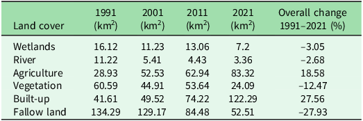
Land-cover maps generated using the MLC tool for the years 1991, 2001, 2011 and 2021 exhibited high accuracy, with overall accuracies ranging from 90% to 94% and kappa coefficients ranging from 0.86 to 0.91 (Table S4). Sensor differences between Landsat-5 and Landsat-8 may account for the lower producer accuracies in earlier years such as 1991 and 2001, potentially introducing minor bias to the historical trend analyses. From 1991 to 2021, fallow land cover declined from 134.29 to 52.51 km2, followed by vegetation cover from 60.59 to 24.09 km2, wetland area from 16.12 to 7.2 km2 and rivers from 11.22 to 3.36 km2 (Fig. 2). In contrast, built-up areas expanded from 41.61 to 122.29 km2, and agricultural land increased from 28.93 to 83.32 km2 (Fig. 2) during the study period. The areas of rivers, wetlands, vegetation and fallow land declined by 2.68%, 3.05%, 12.47% and 27.93%, respectively, whereas built-up and agricultural land increased by 27.56% and 18.58%, respectively, during 1991–2021.
Land-cover map of Srinagar Municipal Corporation for 1991, 2001, 2011 and 2021.

The most significant land-cover transformations occurred in built-up areas and agriculture land cover during 1991–2021 (Fig. S3). The greatest transformation was observed in fallow land, wherein 60.21 km2 were converted to built-up areas and 42.61 km2 were converted to agriculture land cover. All land-cover types contributed to increases in built-up areas: 1.40 km2 of wetland, 1.96 km2 of river, 10.86 km2 of agricultural land, 13.91 km2 of vegetation and 60.21 km2 of fallow land. The rise in agricultural land cover was observed due to the conversion of 3.18 km2 of wetland, 1.01 km2 of river, 24.46 km2 of vegetation and 42.61 km2 of fallow land. In addition to the major conversion of vegetation to agriculture, the analysis indicated a transition of 13.91 km2 to built-up areas and 8.68 km2 to fallow land. Approximately 1.27 km2 of vegetation was transformed into wetlands, while c. 0.12 km2 of wetlands were converted to built-up areas. The conversions of 3.84 km2 of wetlands and 4.56 km2 of river to fallow land highlight the shrinking of waterbodies in the city. Tables 1 & S5 provide detailed overviews of the land-cover changes and transition patterns observed between 1991 and 2021.
Land-cover quantification within Srinagar Municipal Corporation in 1991, 2001, 2011 and 2021.

Table 1 Long description
A table comparing land cover changes in Srinagar Municipal Corporation over four years: 1991, 2001, 2011, and 2021. The table has six rows and six columns. The columns are labeled as follows: Land cover, 1991 (km^2), 2001 (km^2), 2011 (km^2), 2021 (km^2), and Overall change 1991-2021 (%). The rows are labeled with different types of land cover: Wetlands, River, Agriculture, Vegetation, Built-up, and Fallow land. Each row shows the area in square kilometers for each year and the overall percentage change from 1991 to 2021. Notable trends include a significant increase in built-up areas and agriculture land cover, while wetlands, rivers, vegetation, and fallow land have generally decreased. The greatest transformation was observed in fallow land, with a notable conversion to built-up areas and agriculture land cover.
The six landscape indices indicated the characteristics of the wetlands in Srinagar (Table S6). The NP (from 308 in 1991 to 116 in 2021) showed a significant reduction in the number of wetland patches. The PD of wetlands (from 19.11 in 1991 to 7.74 in 2021) indicates a reduction in the number of patches per unit area, with less connectivity among them. Decreases in the LSI (from 15.27 in 1991 to 11.18 in 2021) demonstrate that the landscape shape became more regular, with fewer patches. The SPLIT value decreased from 4.42 in 1991 to 1.30 in 2001 but increased significantly again to 3.13 in 2021, signifying overall greater wetland fragmentation. The decrease in the CONTIG_AM from 0.87 in 1991 to 0.86 in 2021 indicates that the wetland patches were becoming increasingly disconnected. Similarly, the decline in the AI from 89.24 in 1991 to 88.48 in 2021 demonstrates wetland disintegration.
Land-cover validation (2021) and wetland prediction (2031)
Comparison of the projected 2021 land-cover map with the actual 2021 land-cover validated the predicted 2021 land-cover map (kappa = 0.80; chi-square = 9.8522). Details of the chi-square test are presented in Table S7. The Markov chain model showed high accuracy in predicting land-cover changes within the study area. Subsequently, the land-cover map for 2031 was generated using the same model.
The land-cover change analysis conducted for the period 2021–2031 indicates a decline in the spatial extent of wetlands, rivers, agricultural land and fallow land, along with an increase in built-up areas (Fig. S4). Wetlands are expected to decline by c. 0.54% during the period 2021–2031. Rivers are projected to decrease by c. 0.33%, while fallow land is anticipated to decline substantially by c. 1.99%. In contrast, built-up areas are expected to expand considerably, showing an increase of c. 7.27% during 2021–2031. Despite a slight increase of c. 0.11%, vegetation areas remained relatively stable between 2021 and 2031 (Table S8).
Predictions for land-cover transitions between 2021 and 2031 indicate that a total of 26.99 km2 of land, including 0.62 km2 of wetlands, 0.73 km2 of river area, 13.49 km2 of agricultural land, 3.51 km2 of vegetation and 8.64 km2 of fallow land, are projected to be converted into built-up areas (Fig. S5 & Table S9). Approximately 0.33 km2 of wetlands and 0.19 km2 of rivers are expected to be converted to fallow land, signifying the shrinking of these waterbodies. The loss of 1.13 km2 of vegetation to fallow land highlights the growing problem of deforestation in the area. Transformation of land cover from wetlands and rivers to vegetation is anticipated, driven by the encroachment of weeds and other invasive plants, affecting 0.32 km2 of wetlands and 0.04 km2 of river area. Although a significant proportion of agricultural land is predicted to be transformed into built-up areas, other transitions are also expected to contribute to agricultural land increases. Specifically, 0.31 km2 of wetlands, 0.02 km2 of rivers, 1.03 km2 of vegetation and 1.56 km2 of fallow land are anticipated to be converted into agricultural land. These findings indicated that wetlands and rivers may be converted into another land-cover types if current trends in land-cover transition persist.
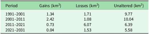
Change detection analysis at Dal Lake and its 2-km peri-lacustrine zone revealed fluctuations in open surface water area, decreasing from 11.49 km2 in 1991 to 11.11 km2 in 2001, increasing to 12.45 km2 in 2011 and declining further to 7.11 km2 in 2021 (Table 2). These fluctuations also exhibited gains primarily attributable to spatiotemporal variability in surrounding land-cover types such as fallow land, vegetation and agriculture. The maximum increase in area was observed during 2001–2011, with a gain of 2.42 km2. The minimum gain occurred during 2011–2021, measuring only 0.73 km2. Similarly, the maximum open surface water area was found in 2001–2011 at 10.04 km2, and this land type then decreased up to 2021 by 6.39 km2. These findings reveal an overall decline in open water surface area at Dal Lake and its 2-km peri-lacustrine zone from 11.49 to 7.11 km2 over the study period, as illustrated in Fig. S6. Projected land cover based on current trends suggests further shrinkage in the open water surface area to 5.62 km2 by 2031.
Change detection within 2-km peri-lacustrine area of Dal Lake.

Table 2 Long description
A table showing changes in gains, losses, and unaltered areas around Dal Lake over different periods. The table has four rows and four columns. The columns are labeled 'Period', 'Gains (km²)', 'Losses (km²)', and 'Unaltered (km²)'. The rows are labeled with different time periods: 1991-2001, 2001-2011, 2011-2021, and 2021-2031. Row 1: 1991-2001, Gains: 1.34, Losses: 1.71, Unaltered: 9.77. Row 2: 2001-2011, Gains: 2.42, Losses: 1.08, Unaltered: 10.04. Row 3: 2011-2021, Gains: 0.73, Losses: 6.07, Unaltered: 6.39. Row 4: 2021-2031, Gains: 0.04, Losses: 1.53, Unaltered: 5.58.
Landscape pattern analysis (1991–2031)
The predicted land-cover map of 2031 shows a reduction of landscape patches from 308 in 1991 to 180 (Fig. S7). The increase in the PD from 19.11 in 1991 to 22.75 in 2031 shows increasing fragmentation, as a higher PD indicates greater fragmentation of the landscape. The shape of the landscape is predicted to simplify with time, as LSI values decreased from 15.27 in 1991 to 13.25 by 2031. In addition, some major wetland patches may become more consolidated, but their overall size could decrease due to peripheral erosion or fragmentation, leading to a more uniform landscape pattern. The anticipated decrease in the SPLIT from 4.42 in 1991 to 2.66 in 2031 highlights the alarming trend of fragmented wetland patches transitioning completely into agricultural and built-up land-cover types. Given the current trends in land-cover change, the decline in the CONTIG_AM from 0.87 in 1991 to 0.81 in 2031 indicates reduced patch connectivity, suggesting that habitat destruction within the wetland is likely to accelerate in the future. The projected decline in the AI from 89.24 in 1991 to 84.21 in 2031 is directly linked to the substantial reduction in wetland area. These negative trends are characterized by a loss of aggregation, resulting in the diminishing of essential ecosystem services.
Discussion and conclusion
The decline in the number of wetlands patches in Srinagar is probably due to the disappearance of smaller and more fragmented wetlands, primarily resulting from agricultural and built-up land-cover type expansion. This pattern was also observed in the Ramsar-designated marshes in California’s Central Valley, wherein decades of agricultural development and urbanization have caused extensive patch loss (Blankenbuehler Reference Blankenbuehler2016). Land-cover transitions in the vicinity of wetlands of Srinagar between 1980 and 2017 have led to a 223% increase in built-up areas and a 95% expansion of road networks (Dar et al. Reference Dar, Bhat and Rashid2021). The region’s floating gardens are gradually solidifying, leading to significant portions of Dal Lake becoming dry land (Rashid et al. Reference Rashid, Romshoo, Amin, Khanday and Chauhan2017). Dal Lake also faces eutrophication due to algal and aquatic weed growth. Moreover, the reduced flow of the streams in the catchment has resulted in decreased inflow into the lake due to changes in the climatic conditions and unplanned urbanization (Rashid et al. Reference Rashid, Romshoo, Amin, Khanday and Chauhan2017). A similar decline in inflows is observed in Lake Naivasha, Kenya, under comparable urban and hydrological pressures (Odongo et al. Reference Odongo, van Oel, van der Tol and Su2019).
Although previous studies have documented similar trajectories of wetland degradation in Srinagar, the present study advances this understanding by integrating multi-temporal RS images, GIS and landscape metrics with predictive modelling up to 2031, thereby identifying future areas of wetland vulnerability and land-cover transition. This approach aligns with international frameworks, such as those applied to predict fragmentation in the Everglades, USA, facilitating achievement of SDG indicator 6.6.1 through systematic monitoring of temporal variations in wetland spatial extent (Ordoyne & Friedl Reference Ordoyne and Friedl2008). The results of this study substantiate the hypothesis that rapid and haphazard urban growth contributes to the degradation and spatial reconfiguration of wetland ecosystems in Srinagar. This is reflected through decreasing wetland areas over decades, with smaller wetlands disappearing completely while larger, intact ones such as Dal Lake undergo fragmentation at both core and edge regions. These patterns are comparable to those observed in Istanbul’s urban wetlands, where edge fragmentation has reduced core areas (Bayraktar et al. Reference Bayraktar, Cegielska, Sökmen, Noszczyk, Yener and Kukulska-Kozieł2024).
To address these trends and mitigate projected fragmentation in ecologically sensitive areas identified through land-cover analysis and predictive modelling, targeted conservation measures should be implemented to prevent further wetland fragmentation. Low-impact development practices, such as permeable pavements and rain gardens, should be promoted in urban catchments to reduce runoff and enhance water retention. Adjacent artificial wetlands should be developed in low-lying areas to preserve vegetation cover, protect bird habitats, promote the growth of endangered plant species and prevent the subdivision of forested patches. Regular desilting of waterway channels and encroached fringes should be conducted to widen outflows, reduce eutrophication and merge fragmented water patches. Riparian buffers and native vegetation should be restored in low-connectivity corridors to enhance aggregation and ecosystem service value. Regular inspection and proper management of sewage treatment plants are essential to connect houseboats and settlements, thereby targeting nutrient inflows from agricultural and urban runoff areas associated with increasing land-cover transitions. Seasonal de-weeding and solid waste removal should be implemented using municipal systems and native techniques. Collectively, these interventions would enhance landscape connectivity by merging smaller water patches into larger contiguous zones without fragmenting lake bodies.
The results from this study provide spatial evidence for planners and policymakers to formulate effective urban growth and wetland conservation strategies to limit future land-cover transformations. Similar patterns of wetland degradation are evident in rapidly urbanizing regions worldwide. Therefore, this integrative approach combining RS, GIS, landscape metrics and predictive modelling provides a replicable framework for other areas facing comparable ecological challenges. This study has only utilized topographic and proximity variables for land-cover predictions. Future research could improve predictive accuracy by incorporating additional climatic and socio-economic factors such as precipitation, land surface temperature, population density, urban centres and suburban areas.
Supplementary material
To view supplementary material for this article, please visit https://doi.org/10.1017/S0376892926100411.
Acknowledgements
The authors are thankful to the editor and the anonymous reviewers for their reviews of this manuscript. AM thanks the Ministry of Education, Government of India, for the PhD fellowship at IIT(BHU), Varanasi. Both authors gratefully acknowledge IIT(BHU), Varanasi, for providing research infrastructure.
Author contributions
AM and VC confirm their responsibility for the following: study conception and design, data collection, analysis and interpretation of results and manuscript preparation.
Financial support
This research received no specific grant from any funding agency, commercial or not-for-profit sectors.
Competing interests
The authors declare none.
Ethical standards
Not applicable.