The McMurdo Dry Valleys are the largest ice sheet-free portion of Antarctica. But just how large are they? Published mentions of the area of the McMurdo Dry Valleys (MDV) are highly variable: 2000 km2 (Chinn Reference Chinn1988), 2500 km2 (McKendry & Lewthwaite Reference McKendry and Lewthwaite1992), 3000–4000 km2 (Keys & Williams Reference Keys and Williams1981), 4000 km2 (Priscu Reference Priscu1998), 4500 km2 (Priscu et al. Reference Priscu, Wolf, Takacs, Fritsen, Laybourn-Parry, Roberts, Sattler and Lyons1999), 4800 km2 (Doran et al. Reference Doran, McKay, Clow, Dana, Fountain, Nylen and Lyons2002), 6000 km2 (Seybold et al. Reference Seybold, Harms, Paetzold, Kimble, Balks, Aislabie and Sletten2009), 6692 km2 (Bockheim & McLeod Reference Bockheim and McLeod2008), 6700 km2 (Bockheim et al. Reference Bockheim, Campbell and McLeod2007), 15 000 km2 (Hopkins et al. Reference Hopkins, Sparrow, Novis, Greorich, Elberling and Greenfield2006). The goal of this list is not to single out individual authors, but rather, to highlight the range of published values. These area estimates derive from diverse sources, including remapping of USGS satellite image maps or GIS tabulations of the areas of mapped surface features (e.g. Bockheim et al. Reference Bockheim, Campbell and McLeod2007), but are overwhelmingly reported without citations of mapping methodology.
Some of this variability can be attributed to which portions of the MDV are considered. For example, including ice-free regions on the Brown Peninsula increases MDV area (Bockheim et al. Reference Bockheim, Campbell and McLeod2007), while defining the MDV as the region bounded by the Ferrar and Mackay glaciers reduces their area (Denton et al. Reference Denton, Sugden, Marchant, Hall and Wilch1993). Likewise, inclusion of ice-covered areas (e.g. glaciers, snow packs) will increase the size of the MDV, while only mapping bare surfaces reduces their size.
These divergent area values propagate through the scientific literature, producing a nearly eightfold range of geographic uncertainty. Accurately determining the ice-free area of the McMurdo Dry Valleys is essential for planning management and science operations in this complex natural laboratory. This note describes an attempt to determine the ice-free area of the McMurdo Dry Valleys using satellite image data.
Methodology
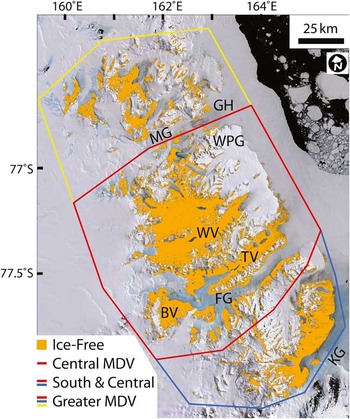
Landsat Image Mosaic of Antarctica (LIMA) (Bindschadler et al. Reference Bindschadler, Vornberger, Flemming, Fox, Mullins, Binnie, Paulsen, Granneman and Gorodetzky2008) tiles covering the MDV were used to map ice-free areas (Fig. 1). LIMA tiles are composed of pan-sharpened Landsat 7 ETM+ data from bands 1–3 (blue, green, and red, respectively, at 15 m/pixel) that were collected under cloud-free conditions from 1999–2002. LIMA tiles were mosaicked into a single image in ArcMap and were resampled to 100 m/pixel using a cubic interpolation in order to reduce the impact of small, seasonal snowbanks on landscape albedo (cubic interpolation weights resampled pixels in favour of surrounding rock/sediment over isolated patches). This also smooths the LIMA mosaic by using a pixel resolution coarser than the ± 54 m one-sigma geolocation error inherent in the mosaic (Bindschadler et al. Reference Bindschadler, Vornberger, Flemming, Fox, Mullins, Binnie, Paulsen, Granneman and Gorodetzky2008).
The McMurdo Dry Valleys. Ice-free areas mapped in orange. MG = Mackay glacier, FG = Ferrar Glacier, KG = Koettlitz glacier, TV = Taylor Valley, WV = Wright Valley, BV = Beacon Valley, GH = Granite Harbour, and WPG = the Wilson Piedmont Glacier. Base image is the true colour LIMA mosaic. The Brown Peninsula is located east of the Koettlitz Glacier.

LIMA data extend past the limits of the MDV, so it is necessary to define the region where the ice-free portions of the MDV could be present (Fig. 1). LIMA data were clipped based on three boundaries: 1) the greater MDV, adapted from the MDV Antarctic Specially Managed Area (ASMA) boundary (USAP/ANZ/PNRA 2011), 2) the south and central MDV (approximately from the Wilson Piedmont to the Koettlitz glaciers), and 3) the central Dry Valleys from the Ferrar to Mackay glaciers.
Ice-free areas can be identified by inspection of three-band LIMA mosaics. To automate the mapping of ice-free areas, Band 1 (blue) data were reprocessed to exclude all pixels with scaled reflectance digital number (DN) values >110. This removes snow/ice pixels because snow and ice reflect strongly at short wavelengths, while rock and soil do not. The 110 threshold was selected by test-fitting DN cut-offs from 100–150 using sites in Taylor, Wright, and Beacon valleys, and manually comparing the results to inspection of natural colour images. Differences in Band 1 threshold of ten DN are visually apparent and produce relative differences in mapped ice-free area of c. 6% per ten DN based on intercomparison of reclassified rasters: a threshold of 100 DN under-represents ice-free regions, while 120 DN over-classifies ice-free regions. Ice-free pixels were converted into a vector shapefile, and the ice-free surface area was calculated. Transformation of the data into a shapefile removes projection errors in pixel area in the raster dataset by accounting for geographic variation in pixel size inherent to data projection. The shapefile is available at www.mcmlter.org.
Results and discussion
The greater MDV have a total area of 22 700 km2 and an ice-free area of 4500 km2. The south and central MDV have a total area of 16 400 km2, of which 3800 km2 is ice-free. The central MDV have a total area of 12 200 km2 and an ice-free area of 3000 km2. Intercomparison between different mapping thresholds (see previous section) suggests that the actual ice-free area of the MDV is within c. 10% of the values reported here.
Notably, these ice-free area values are smaller than the previously discussed areas (modal around 4000–4800 km2). Possible sources for this discrepancy may come from previous papers conflating total area with ice-free area (e.g. c. 15 000 km2), or using hand-mapped area estimates made at c. 1:500k from 1:100k USGS satellite image maps (e.g. 4000–5000 km2), which would overestimate area. Determining the ratio of MDV area to ice-free area may prove to be valuable for planning logistics for future airborne science operations, including LiDAR, airborne geophysics etc., which may attempt to characterize the physical properties of small and spatially-isolated ice-free areas. Most importantly, these results provide a common baseline for providing geographical context for future MDV-related publications. I strongly encourage MDV researchers to be specific about which portion of the Dry Valleys they are describing when area estimates are given, and to consider using the reproducible baseline reported here as an empirical alternative to the propagation of diverse estimates of MDV ice-free area.
Acknowledgements
This work was supported in part by the NSF Office of Polar Programs Antarctic Earth Sciences Program, award ANT-1212307. The constructive comments of the reviewer are gratefully acknowledged.