Introduction
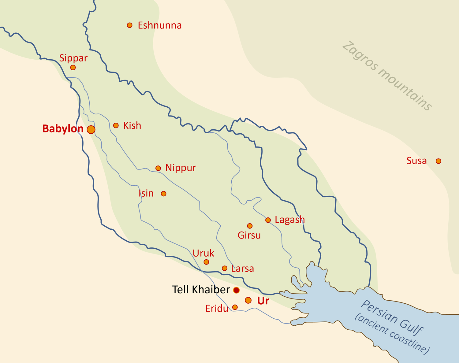
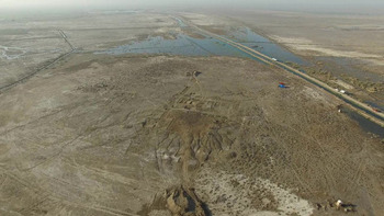
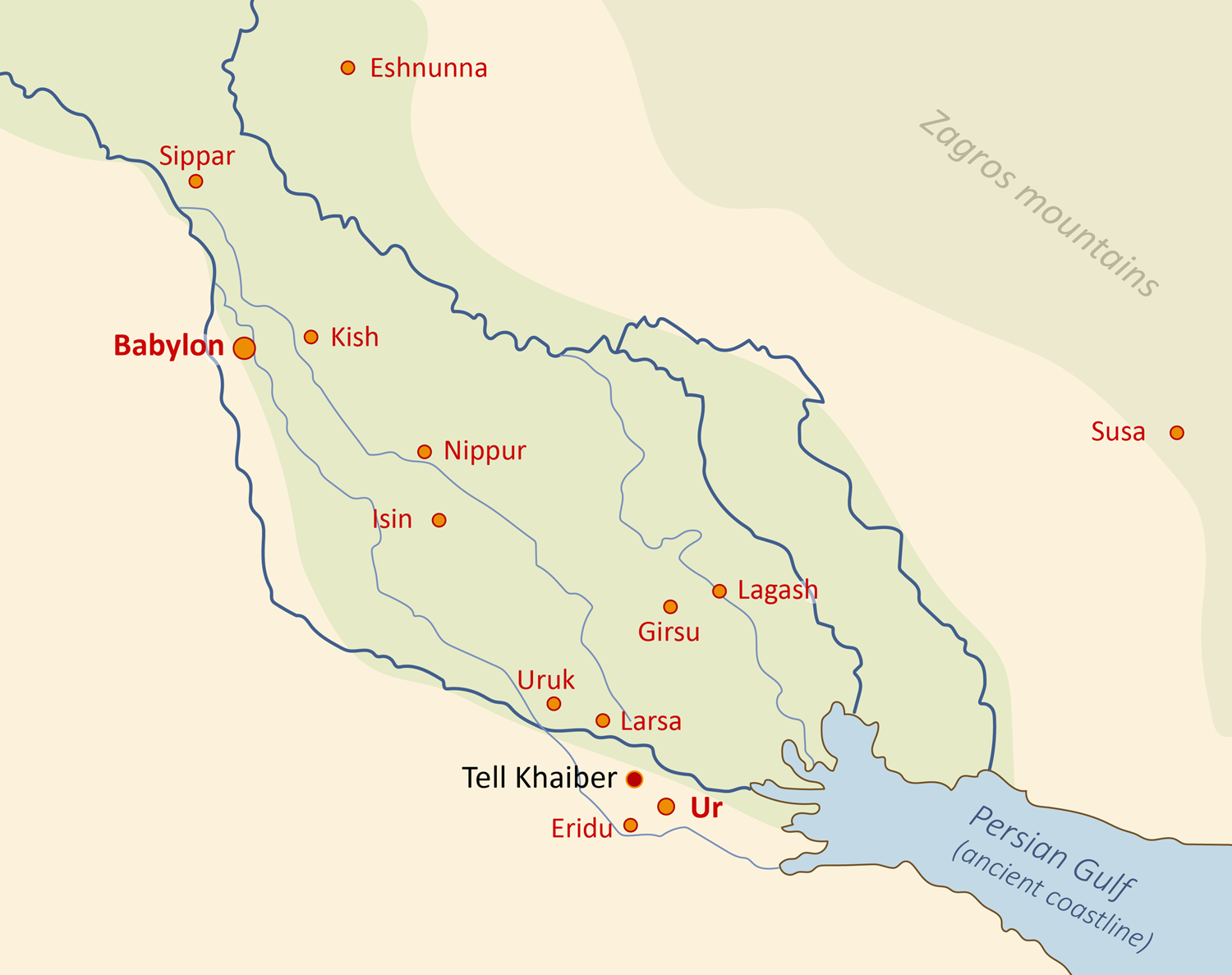
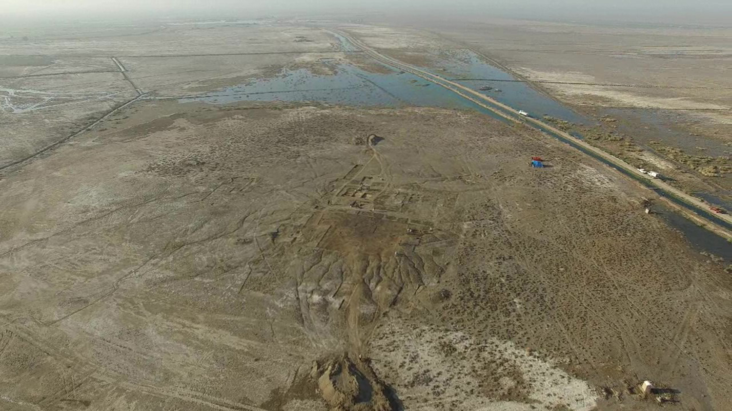
The site of Tell Khaiber lies in southern Iraq, 19 km northwest of Ur and 25 km south of Larsa (Fig. 1). It consists of a small, low mound, measuring just c. 300 m x 250 m and rising no more than 2–3 m above the surrounding plain (Fig. 2). Tell Khaiber was excavated by the Ur Region Archaeology Project, based at the University of Manchester, over five seasons between 2013 and 2017. This was one of the first field projects to return to southern Iraq in the post-Saddam era. Survey and remote sensing showed the site to be dominated by a large, fortified building with only ephemeral traces of a few smaller, possibly contemporary, buildings closely adjacent to it. The material culture associated with the building was Old Babylonian in character with little to distinguish the ceramics from any other site of this period. Later remains were limited to a robbed-out Kassite baked brick tomb, dating to the period in which the site served as a burial place for the nearby Kassite successor settlement of Tell Khaiber 2.
The location of Tell Khaiber relative to other major second millennium b.c. sites and the contemporary Gulf coastline.
Tell Khaiber under excavation in 2016.
The recovery of a cuneiform archive from the fortified building proved key to its interpretation. The texts are dated primarily to the reign of king Aya-dara-galama, the eighth king of the first Sealand Dynasty (c. 1500 b.c.). The context in which the texts were found securely dates the use of the building and makes it clear that the settlement was part of the Sealand state.
The Sealand Kingdom was a second millennium b.c. kingdom which emerged in the southern alluvial plain as a rival to Babylon during the political instability following the death of Hammurabi. Relatively little is known about the Sealand Kingdom, and no other securely identified Sealand settlement has been excavated prior to the project at Tell Khaiber. The extent and settlement hierarchy of the Sealand Kingdom cannot currently be reconstructed, as there is no way to securely identify Sealand settlements from surface material, but the period is characterised in southern Mesopotamia by the contraction of major urban centres, presumably in favour of smaller, more rural sites (Stone Reference Stone, Young and Levine1977). Tell Khaiber represents our first clue to the kind of settlements the Sealand state built.
In light of the identification of the Tell Khaiber building as belonging to the little-known Sealand State, the major research questions for the project became: what was the function(s) of the building, what can it tell us about the economic and administrative structure of the Sealand Kingdom, and how can it add to our knowledge of the wider political context of the Sealand State in the mid-second millennium b.c.?
The form and development of the Tell Khaiber building
The Sealand period settlement at Tell Khaiber re-occupied a much earlier settlement mound, dating from the Uruk to the Early Dynastic period (Calderbank and Moon Reference Calderbank, Moon, Heffron, Stone and Worthington2017). It lies close to an old branch of the Ur Channels, a series of smaller branches of the Euphrates which supported ancient settlement in the area (Wright Reference Wright and Adams1981: 330; Pournelle Reference Pournelle2003: fig. 26). Today, the land around the site is often waterlogged during the winter months, but in the mid-second millennium b.c. the area was wetter, possibly to the extent that it could be considered to be part of the marshes (al-Dafar Reference al-Dafar2015: 126). The old settlement mound would have provided higher, drier ground on which to construct the new building. There were two distinct phases of construction: a small original building, which was later expanded by the addition of a much larger extension.
The original building
The initial Sealand building at Tell Khaiber was small compared to the building's final form. It was placed on the highest point, at the centre of the pre-existing mound, suggesting that at this time the large extension which would later be added to the northeast was not yet envisaged.
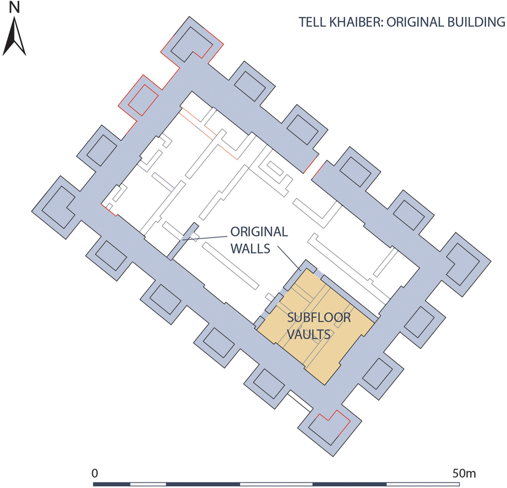
The first part of the structure to be built was the 3.3 m thick perimeter wall with its distinctive towers, describing a rectangle measuring approximately 53 m x 27.5 m. The wall and towers were constructed as a single structure built from the same level. The first few courses of mudbrick acted as a foundation, with the bases of the towers built as solid blocks without the internal voids characteristic of their superstructures. This solid foundation brickwork, underlying the upper walls of the towers, was the only floor provided to the chambers within the towers; they do not have packed earth or plaster floors as the rooms inside the building do. This, along with the deposits found in the excavated chambers, suggest that the internal spaces within the towers were not originally accessible.
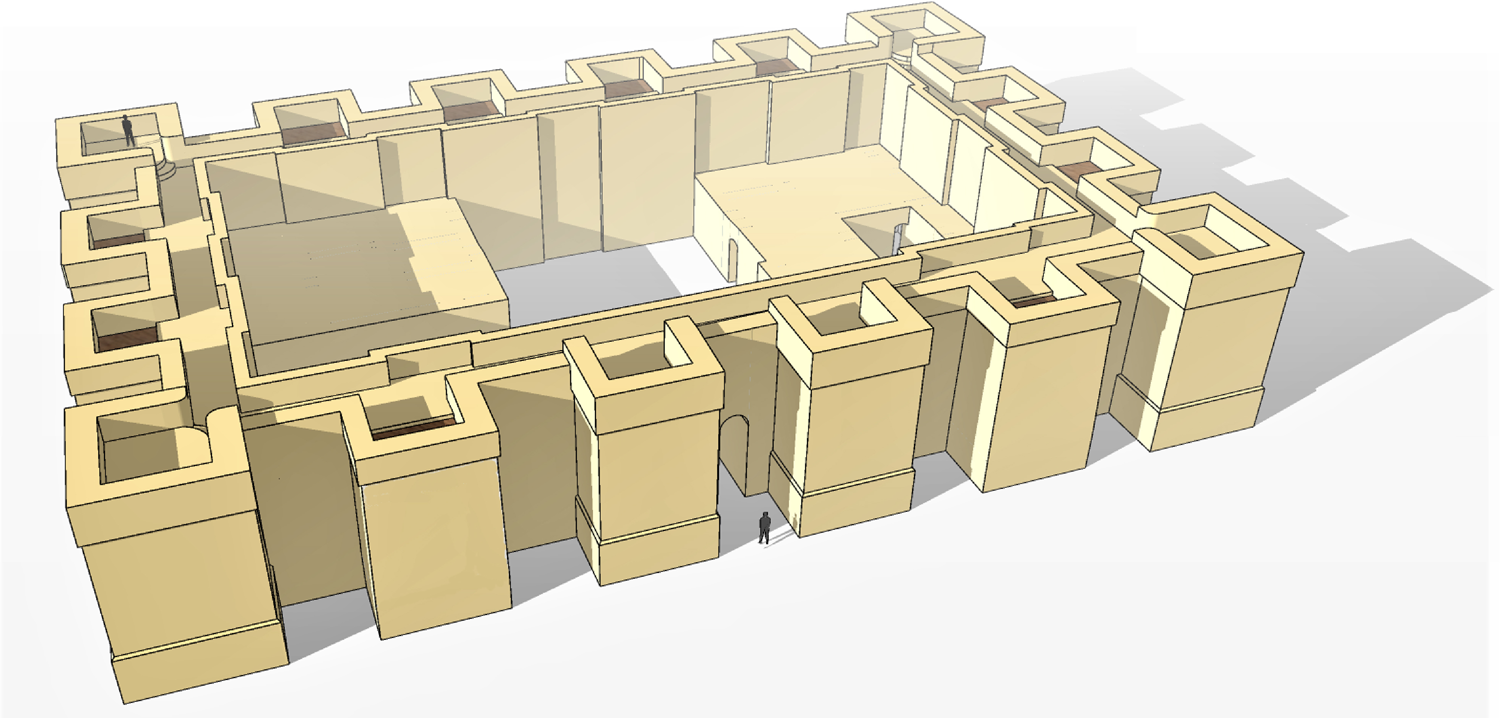
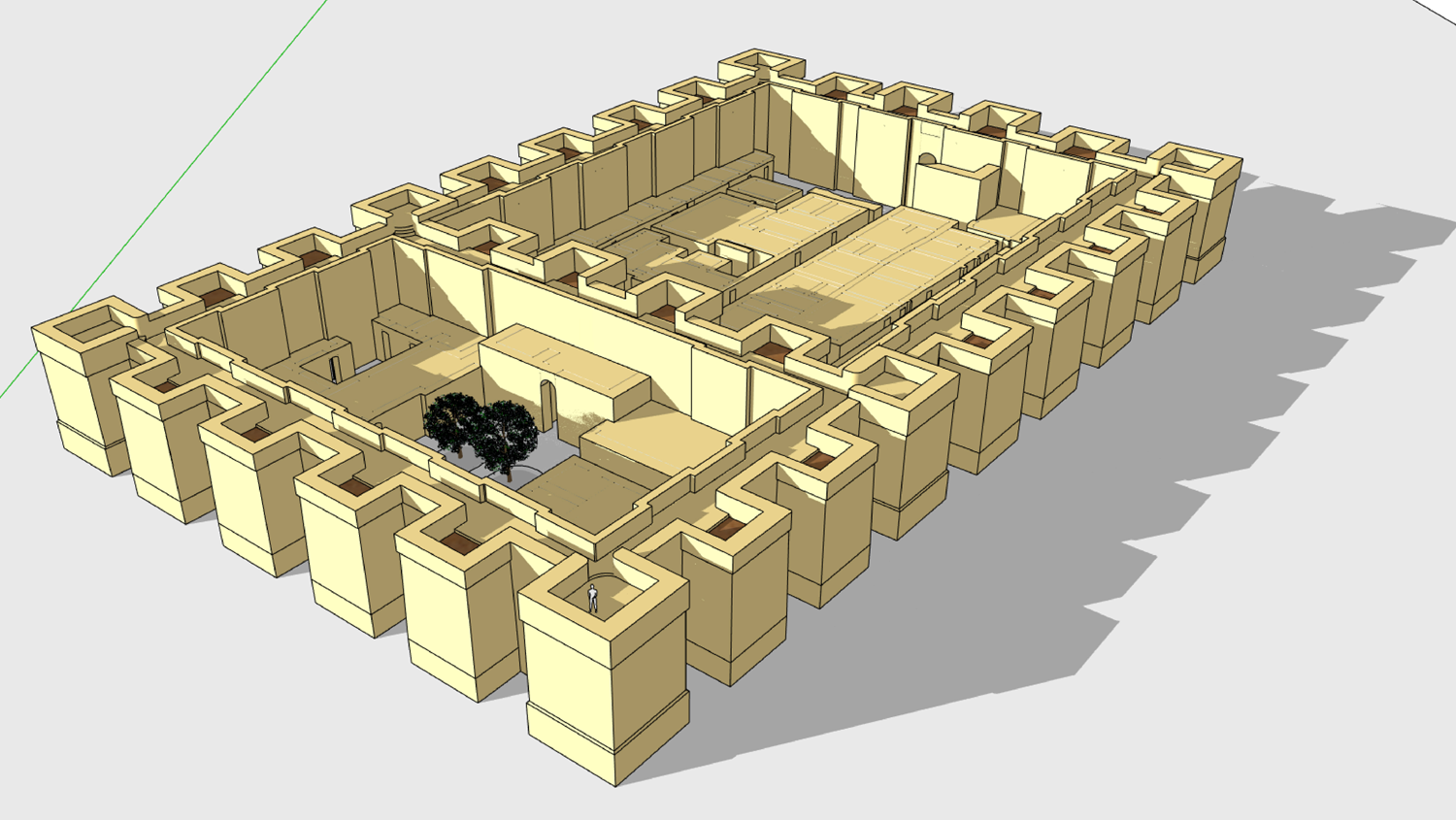
The massive outer wall and prominent towers would have given the small building a heavily fortified appearance and made it a strong defensive structure. There was just a single narrow entrance between two towers at the centre of the long northeast side (Fig. 3).
Reconstruction of the appearance of the original building at Tell Khaiber. The perimeter walls and towers are modelled at 8 m high; the interior is largely conjectural but is based on the scant evidence for the early layout provided by excavation. View facing SW to show the entrance; lighting approximates 8 AM equinox shadows.
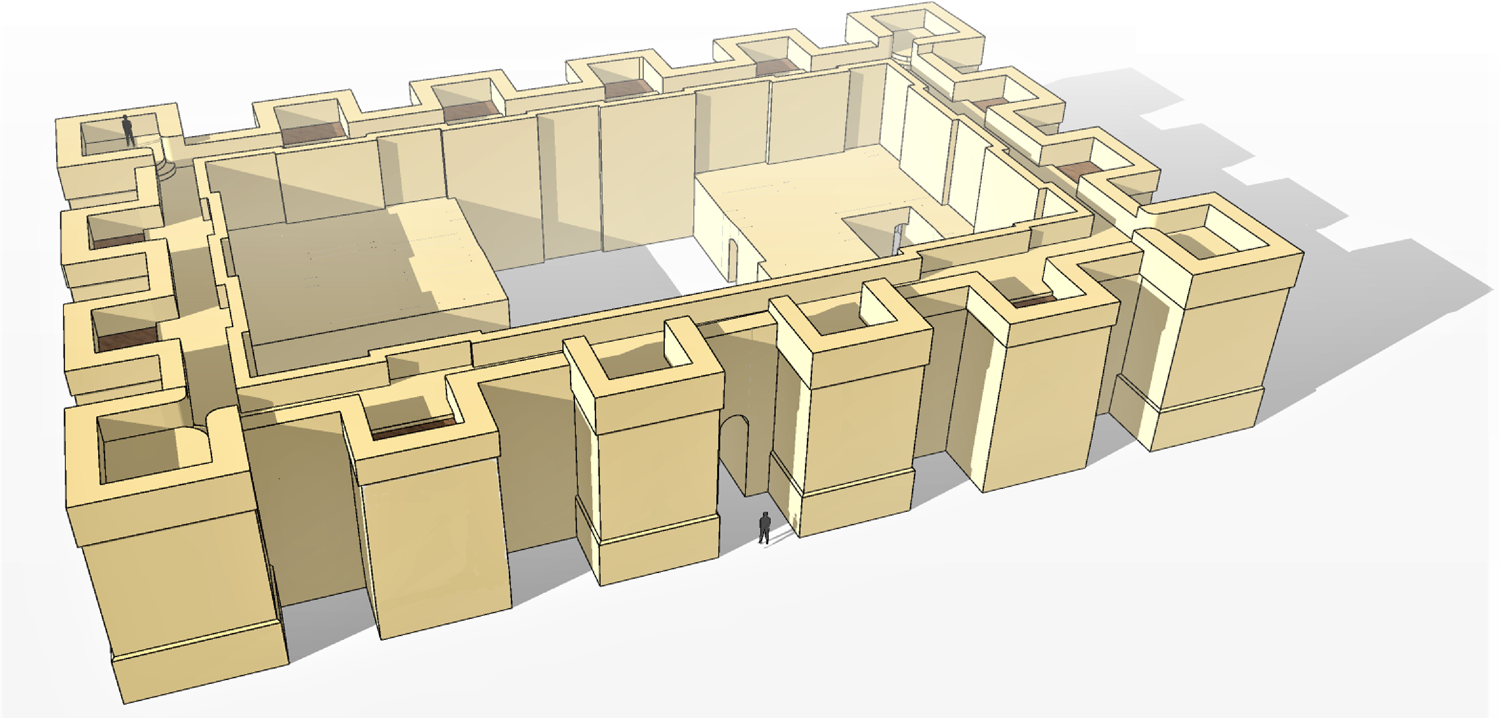
As well as projecting almost 3.5 m outward from the exterior face of the wall, each tower, except the two by the entrance, also had a small corresponding projection on the inside face of the perimeter wall, just one mudbrick wide, so that the internal façade of the wall was stepped in a continuous, regular pattern which appears purely decorative. At first this was thought to indicate that the inside of the building was originally meant to be open space so that this design could be seen, but this possibility appears to be contradicted by excavation which identified several internal architectural features built from the same construction horizon as the main perimeter wall. What seems more likely is that the main wall rose well above the height of the building's internal architecture, so that a substantial portion of this decorative façade remained visible above.
Sub-floor vaults
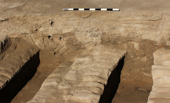
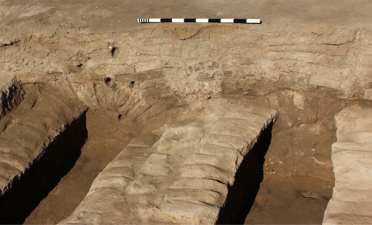
Very little is known about the early internal layout of the original building. The interior was almost completely remodelled at a later point, most likely when the extension was added. The main surviving original feature is a series of long, narrow, sub-floor vaults, which run below the southern corner of the building for a length of 12 m, between the southeast outer wall and the central courtyard. They are not found under any other excavated part of the building (Figs. 4, 5).
The ends of the northern-most sub-floor vaults meeting the arches in the courtyard wall.
Plan of the original Tell Khaiber building. Walls identified as original are shaded grey (blue in online version), and the area underlain by the subfloor vaults is indicated in light grey (orange in online version).
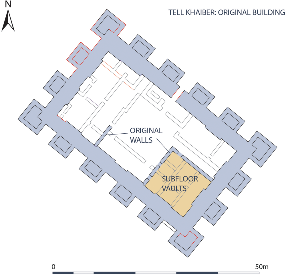
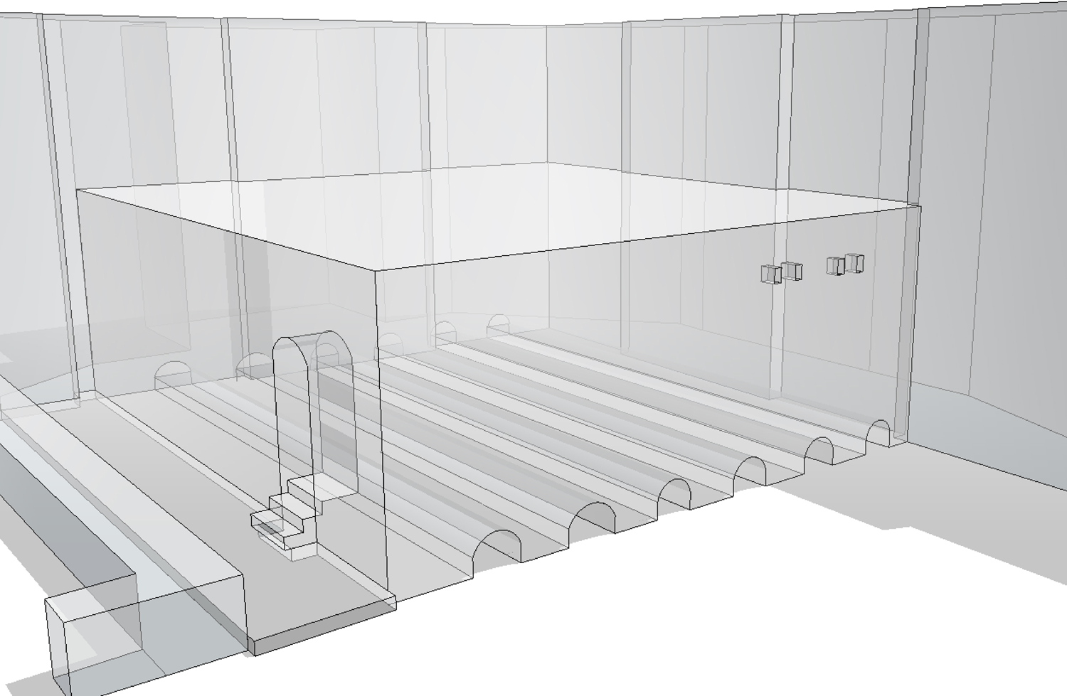
The vaults themselves are 75–85 cm wide and would have stood approximately 80 cm high, roofed with pitched barrel vaults. The bases of the vaults lie at exactly the same level as the base of the main outer wall, showing them to be part of the original construction. The same applies to the walls marking the limits of the vaults within the building. The wall separating the vaults from the courtyard is of particular interest because, at its lowest level, arches were built into the wall to receive the ends of the long vaults. These arches are not a continuation of the long barrel vaults but are separately constructed as part of the courtyard wall. Excavation in the courtyard showed that the arches would have stood at least partially above ground level in the courtyard during the building's early phase, so that the long vaults would have had openings into the courtyard, with the rooms over the vaults raised above the courtyard level (Fig. 6).
Reconstruction showing the sub-floor vaults under the southern quarter of the original building, with their ends opening into the courtyard area. Image produced using SketchUp.
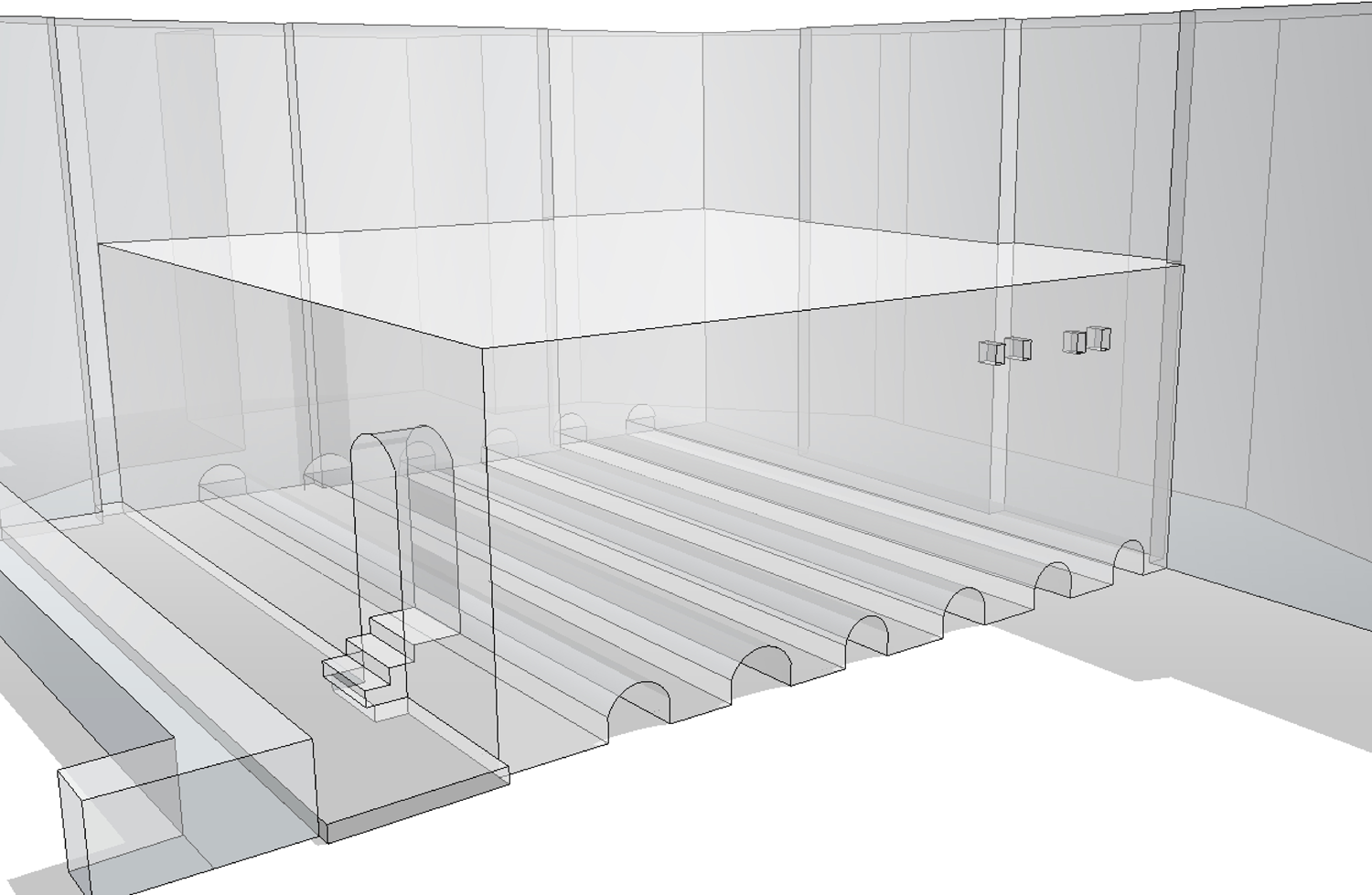
As the sub-floor vaults seem extremely ill-suited to storage, we must look for other possible functions. Ventilation is one. Elevating this quarter of the building over open vaults would result in greater airflow, which would have kept the rooms above much drier. This was necessitated either by the use of this part of the building for the storage of goods, such as grain, which needed to be kept especially dry (Breckwoldt Reference Breckwoldt1996: 65), or because this area had a particular problem with dampness. The former appears more likely, as this corner lies on relatively high ground, and the need for the vaults did not persist after the remodelling of the building.
Surrounding structures
Traces of a few buildings surrounding the large fortified building could be seen on drone and satellite images, the clearest lying in an area approximately 40 m southeast of the fortified building. A combination of surface scraping and excavation revealed the poorly preserved foundations of three mud-brick buildings. The thin walls were preserved to just a few centimetres high and doorways were difficult to identify. It remains unclear what these buildings represent, and there are some ceramic indications that they may post-date the fortified building, but they have been tentatively interpreted as private houses (Campbell et al. Reference Campbell, Moon, Killick, Calderbank, Robson, Shepperson and Slater2017: 7–8). Less substantial building traces to the southwest yielded little on excavation, just a wall fragment and a tannur base. Other test trenches outside the fortified building revealed no further traces of second millennium b.c. occupation. These results suggest that the surrounding settlement was relatively limited and that it was dominated by the fortified building, both in its original and later expanded form.
From the excavated evidence we can say that the original Sealand building at Tell Khaiber was relatively isolated, built on high ground, heavily fortified, with a central courtyard and a raised architectural space protected from damp.
The Northeast Extension
Sometime after construction of the original building, a larger extension was added to its northeast side. This tripled the size of the building, taking its area from 1,460 m2 to 4,400 m2. The outer wall and towers of the extension exactly mimicked those of the original building in both form and material, and the base of the new construction lay at almost the same level as the older building. This suggests that relatively little time had elapsed between the completion of the original building and the addition of the extension. It even seems likely that they were constructed by the same builders. However, the fact that the extension was never part of the original plan is made clear by the necessity of incorporating what were plainly once external towers along the northeast side of the original building into the internal plan of the extended building. The original narrow entrance through the northeast wall became an internal doorway, with a new external entrance almost certainly situated on the same alignment through the new northeast fortification wall; although this area is poorly preserved there is nowhere else it could be, and small fragments of preserved wall are consistent with the proposed gate structure. It should be noted that the tripling of the building's size did not give rise to a second entrance. This suggests that the defensive advantage of a single entrance was prioritised over day-to-day convenience for the expanded use and population of the building.
Most of the internal plan of the northeast extension was recovered through surface scraping, so it is not clear how much of it reflects the original layout and how much represents later alterations or incomplete preservation. However, our limited excavation suggests that only relatively minor changes were made to the internal plan after the initial construction phase, and that the main features of the currently visible organisation and layout are original. Only seven of approximately eighty rooms were excavated, but the results provide important insights.
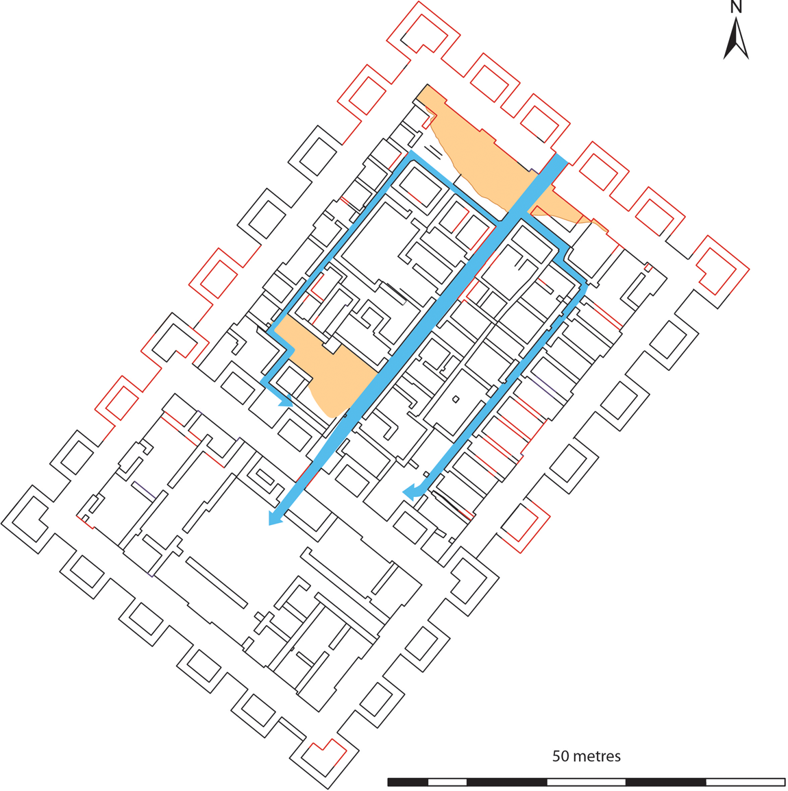
Unusually, the interior of the northeast extension was organised around three long, parallel passageways, rather than one or more courtyards (Fig. 7). Excavations suggest that these passageways were part of the original plan and present throughout the life of the building. The central passage is wider than the other two, at approximately 2 m. It runs from the northeast entrance gate, down the central axis of the building, to the old gateway into the early building. This was clearly the main route through the Tell Khaiber building, and it meant that the original part of the building could be accessed without passing through any other architectural space in the extension. The two narrower passageways, which are just 1 m wide, run parallel to the main central route, one on each side, and gave access to the ranks of small rooms which line the long outer walls of the extension. The southeast passageway was accessed from the northern entrance gate but led down to a dead-end, terminating in two irregular-shaped larger spaces which seem likely to be unroofed to supply light and air to the surrounding rooms. These perhaps provided some outdoor activity space in lieu of the large central courtyards usually found in contemporary buildings of this size. The northwest passageway was also accessible from the entrance gate, but its western end is uncertain due to an area of poor preservation caused by a large surface rainwater gully. Like the southeast passageway, it appears to terminate into larger architectural spaces and does not seem to connect back to the central passageway.
Overall plan of the Tell Khaiber building in its latest preserved form. The three passageways around which the Northeast Extension is arranged are highlighted in dark gray (blue in online version); dashed wall lines (red in online version) are uncertain or reconstructed; light grey shading (orange in online version) indicates areas where the architecture was unrecoverable.
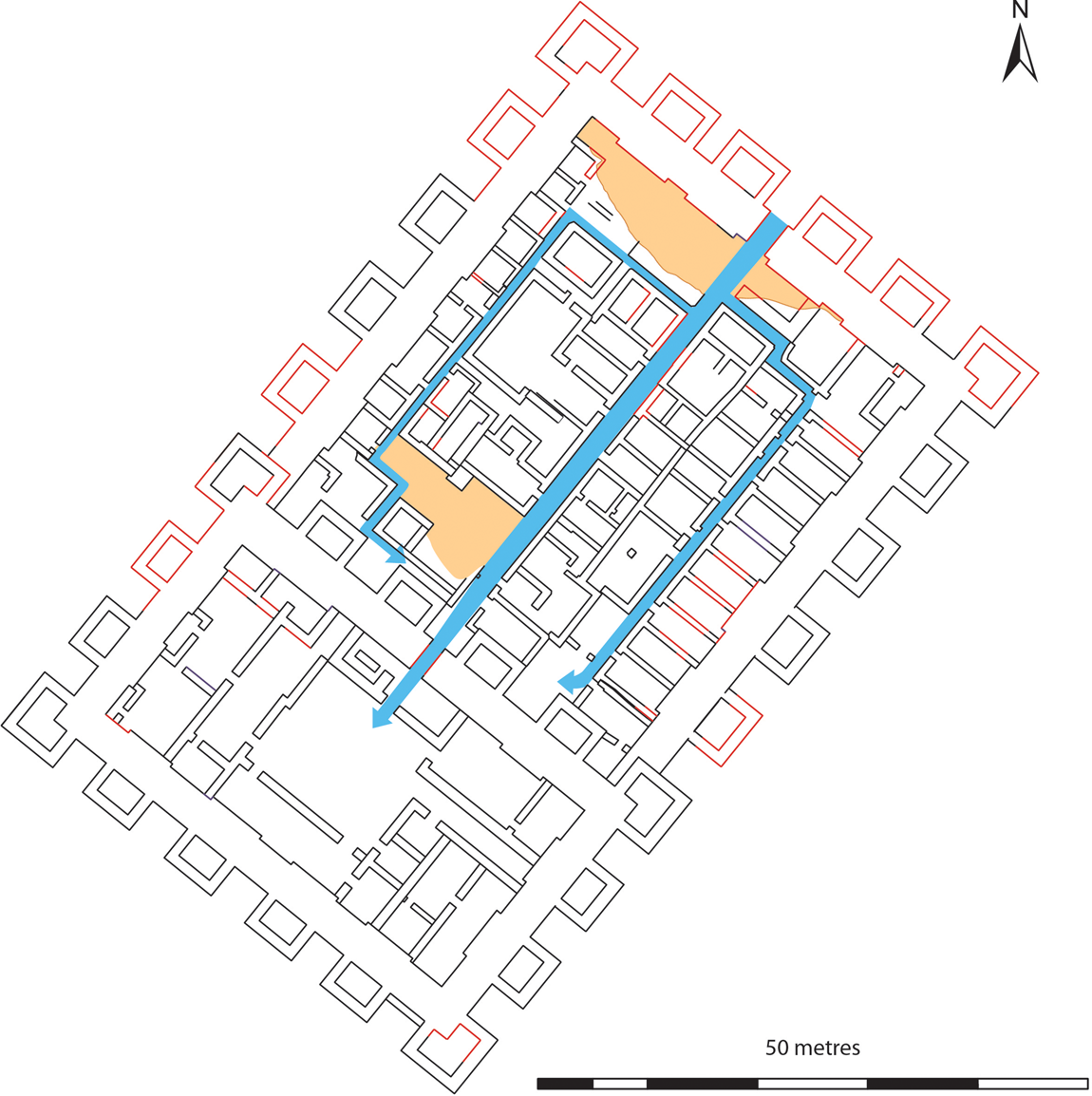
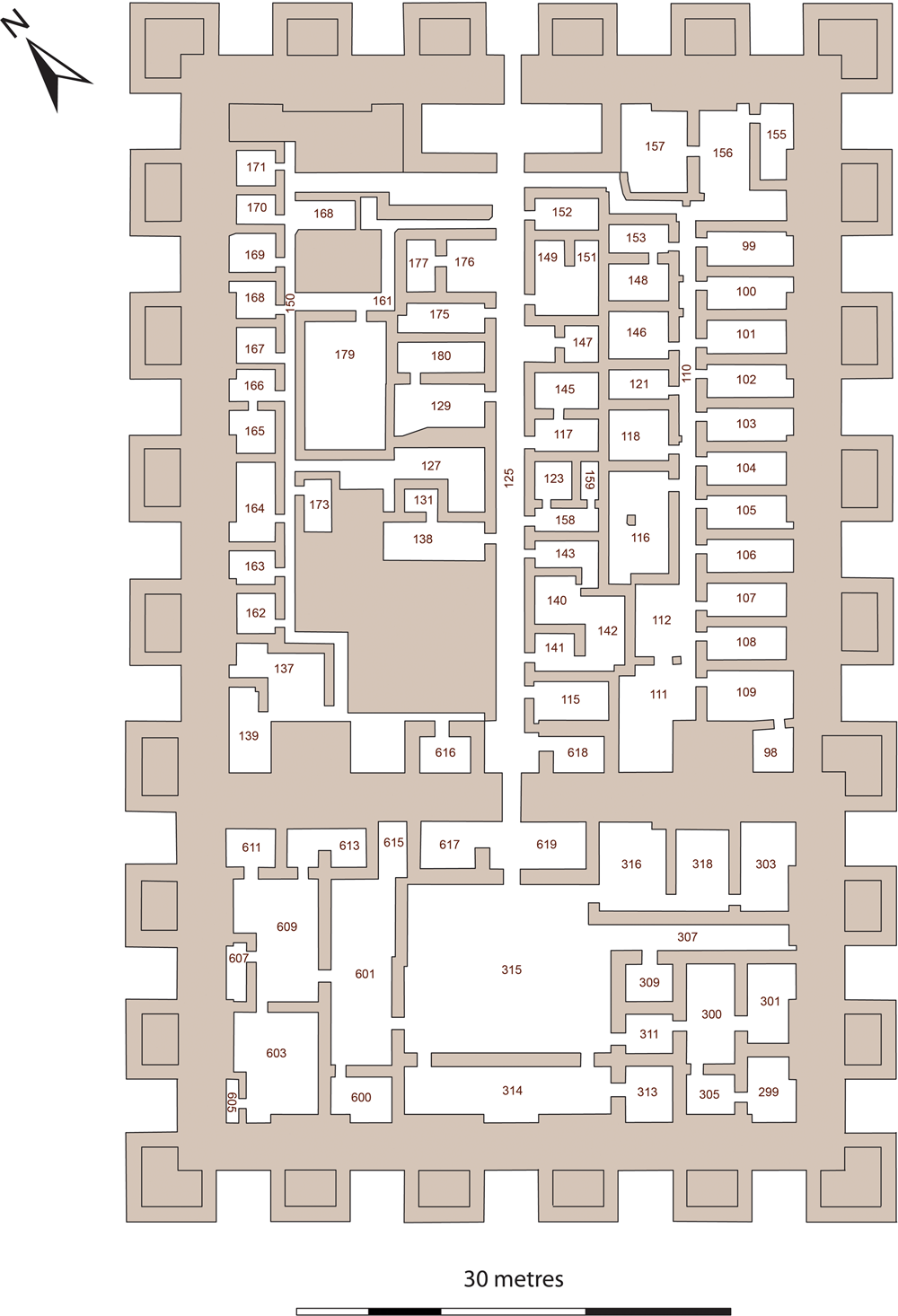
The ranks of small rooms which line the long outer walls of the extension were initially thought to be storage magazines, related to one of the building's main functions as revealed in the cuneiform archive, the collection and redistribution of agricultural products (Campbell et al. Reference Campbell, Moon, Killick, Calderbank, Robson, Shepperson and Slater2017). However, this does not appear to be the case. The most regular set of these small rooms is the rank of ten virtually identical rectangular rooms, 99–108 (for room numbers, see Fig. 11), along the southeast side of the building, each measuring approximately 5.4 m x 2.5 m. One of these, room 101, was excavated down to the earliest floor levels, at a depth of 1.2 m, and the results showed not only that these rooms were part of the original layout of the building, but they were likely to be residential. The walls of the room were constructed from the same level as the building's main outer wall. In the northern corner of the room was a bread oven, which was a recurring feature of the room, having been rebuilt multiple times on various plaster floor levels. Instead of storage vessels, most of the pottery from this room consisted of cooking vessels, bowls and cups. The room fill was made up of many fine layers of compacted ash and greenish material, often containing reed or straw impressions, suggesting a build-up of oven waste and organic material over time, perhaps including reed matting or loose bedding. There was a high density of ceramic fragments, animal bones and other small finds suggestive of living quarters.
Surface scraping of the other rooms in this row indicates a uniform function. The tops of bread ovens were visible in almost all of the rooms, all of these located at the northwest end of the rooms adjacent to the long passageway 110. Each of these rooms probably had a doorway letting onto the passageway, although not all of these doorways were detectable at the surface. Overall, this rank of rooms appears to represent an accommodation block, with each of the ten identical rooms large enough to sleep perhaps up to ten people, and each equipped with a small oven for cooking and warmth. Room 155 in the northeast corner of the building may also serve the same function, as it has almost identical dimensions. Its doorway is on the long side of the room rather than the short end, but it opens in the same direction as the other long narrow rooms and also connects to passageway 110. The fact that narrow passageway 110 which gives access to these rooms terminates in a dead end would have made the accommodation block private in terms of access, as discussed below, with no through-route to any other part of the building.
The rank of rooms along the opposite northwest wall (162–171, for numbers see Fig. 11) is considerably less regular than the southeast accommodation block, but it still presents a series of rooms of sufficient uniformity to imply a common function. There are nine small square rooms, each measuring approximately 3 m x 3 m. Where doorways are recoverable, most of these small rooms open onto the other narrow flanking passageway 150, along which they are arranged, but at least one (166) opens into an adjacent room. Roughly at the centre of the row is a larger rectangular room (164), approximately double the size of the square rooms, leaving space for uncertainty about whether a dividing wall might have been missed.
Interpretation of the northwest row of rooms is more difficult because none of these rooms were excavated. However, it seems likely, due to the symmetry of form and position with the southeast row of rooms, that this was also an accommodation block. The absence of ovens in the northeast rooms is likely explained by their much smaller size, and it is notable that, possibly in compensation, there are at least three bread ovens in the area in which the northwest passageway terminates, perhaps representing a communal cooking area for this accommodation block. With smaller rooms, presumably holding a smaller number of residents, and situated on the opposite side of the building to the larger accommodation block on the southeast, we can speculate that this wing accommodated a different type or rank of personnel.
Unlike the southeast accommodation block, which appears mostly unaltered, the northwest row of rooms shows signs that some walls represent alterations or additions to the original layout. The presence of multiple phases of reconstruction and alteration in the northeast extension are confirmed by excavations carried out in a suite of rooms (140–143) near to the internal gateway into the original southern building, accessed from the main central passageway. Although the outer walls of this suite were unchanged from the earliest phase, the internal division of the space and positioning of features varied over time, with at least five phases of minor alteration in evidence and several distinct floor levels, one bearing clear impressions of carefully laid reed matting. The function of this suite remains unclear, as is the case for most of the rooms of the central part of the northeast extension, but appears broadly residential and domestic. Presumably many of the central rooms were used for activities other than accommodation, such as storage, food preparation, workshops and communal spaces. The irregularity of parts of their layout appears to be a product of these diverse functions, multiple phases of change and the vagaries of wall preservation at the surface.
The original building in its later phase
The original southern part of the fortified building underwent a significant remodelling at some point, taking on the form now traceable at the surface of the tell. This remodelling may be linked to the addition of the extension, although this was not demonstrated conclusively in excavation. The development of the structures leaves the original building and the northeast extension highly isolated, linked stratigraphically through just a single narrow doorway. However, when the extension was added, many of the functions crammed into the small original building must have been transferred to the new structure, so some re-arrangement was almost certainly necessary at this time.
One of the original features which became redundant is the sub-floor vaulting under the southern corner. Whatever structures may originally have stood over the vaults were removed and the floor level was reduced to truncate the tops of the vaults. The vaults were then packed to the top with a sterile, homogeneous fill. New walls were laid out, with their foundations cutting into the tops of the truncated vaults below, and fresh floors were laid in each of the rooms. This new suite of rooms appears to have been the administrative or scribal wing. More than 150 tablets and tablet fragments were recovered from this area, the majority spread through three of the rooms (309, 311 and 300). Whatever purpose was originally served by the elaborate system of vaulting, it was no longer required for the scribal suite. Between lowering the floor height in the formally vaulted area and the gradual rise in the level of the courtyard as the plaster floor was continually renewed, the new administrative wing and the courtyard were now more or less on the same level.
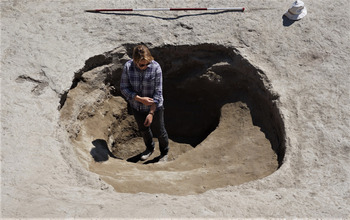
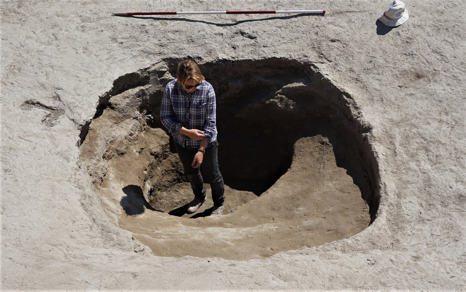
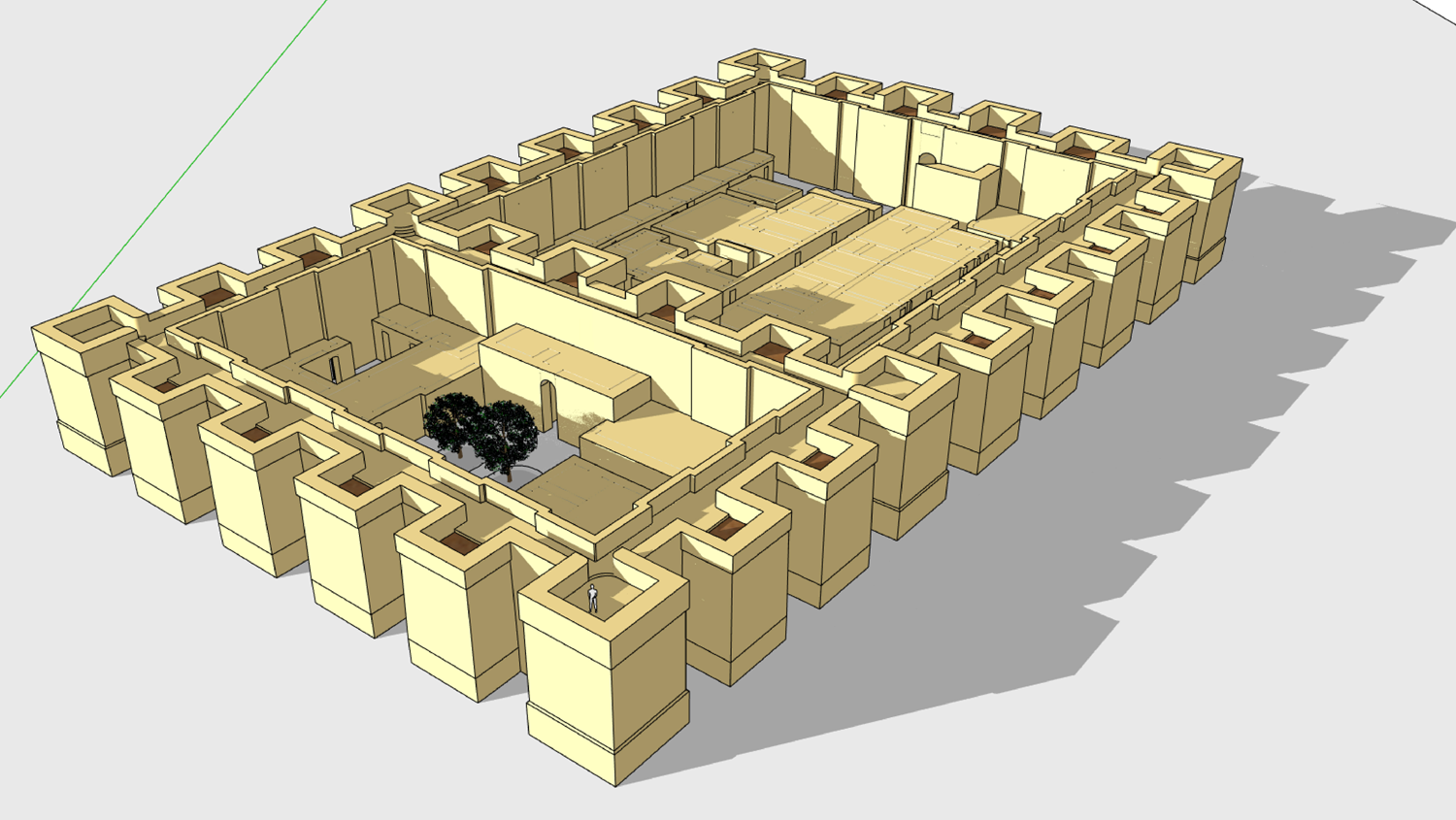
The courtyard, which seems to be an original feature from the building's first phase, measures approximately 14 m x 12 m. Due to this large area, only the southeastern half was excavated, but even so, the earliest floors were not reached. The excavated stratigraphy shows a dense series of mud plaster floors with a depth of more than a metre. The courtyard was clearly a busy and constantly changing activity area, and a different set of benches, bases, bins and clay ovens was provided on each of the excavated floors. The most notable and persistent feature, however, was a large, roughly square depression in the centre of the excavated half of the courtyard (Fig. 8). Excavated to its base, the nature of this deep pit and its deposits makes it highly probable that the depression was produced by the presence of a large tree, which must have stood in the courtyard for some considerable time. The courtyard is large enough that much of its space would have been unshaded for long periods of the day, so a substantial tree, as indicated by the size of the depression, would have provided welcome shade. Trees also help to cool the air of semi-enclosed spaces such as courtyards through transpiration, making the addition of a tree a good climatic adaptation, common in traditional courtyard houses to the present day. The stratified deposits suggest that the courtyard tree had a long life, predating the lowest excavated floor and persisting through all but the latest few preserved floor levels. All of the excavated floors slope significantly towards the large depression caused by the tree over time. It is tempting to hypothesise a second tree placed symmetrically in the unexcavated half of the courtyard (Fig. 9), but this is of course unproven.
The large tree pit at the centre of the excavated half of the courtyard, into which all excavated floors dipped.
Reconstruction of the Tell Khaiber building, viewed from the south, with a pair of trees modelled in the courtyard of the original building.
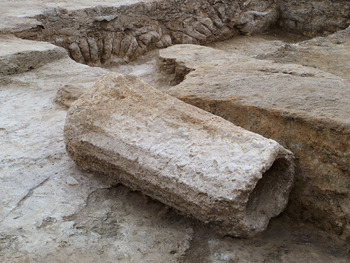
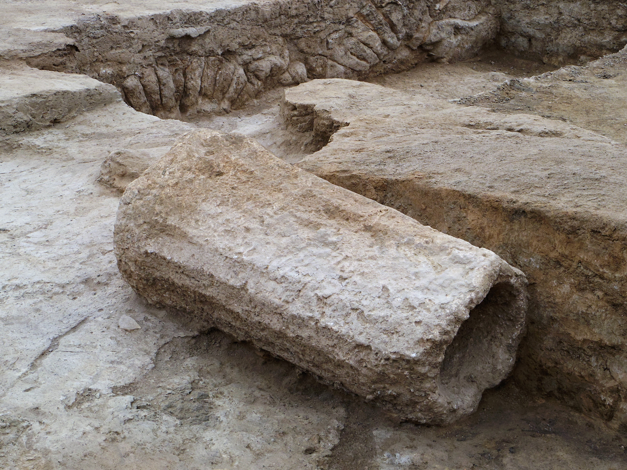
Large trees were not the only touch of grandeur in the courtyard. On the lowest excavated floor, traces of a row of mudbrick pedestals were found running close to the southwest wall, as well as a tall stone basin lying on its side next to the southern doorway. This is the only large piece of stonework found at Tell Khaiber (Fig. 10). It lies outside the doorway leading to a long room (314) separated off from the courtyard, which was added when the original building underwent its major remodelling. This large room on the southwest side of the courtyard is positioned as the main reception room in the standard spatial organisation of second millennium b.c. Mesopotamian domestic and palatial architecture. At least in its later phase, the reception room was provided with two doorways from the courtyard, allowing access from either end of its length and providing the room with extra lighting from the courtyard. Although the floor levels of the reception room were not well preserved, there are hints of more palatial elements in the form of yellowish plaster applied to the floor and walls. Similar plaster also occurs in some rooms of the administrative suite.
The stone basin outside the eastern doorway into the reception room.
The presence of a reception room in the Tell Khaiber building suggests that it had some formal or elite functions and may indicate the presence of a governor or senior administrator of some kind, who was expected to entertain peers or superiors from time to time. The later addition of a reception room could indicate that the formal functions of such a space were only acquired after the northeast extension was added and the expanded building assumed a greater level of importance within the Sealand administrative system. As a whole, the original part of the building in its later form has strong similarities with the layout of an elite residence and may in some respects have functioned as such.
Interpreting the building at Tell Khaiber
Spatial analysis
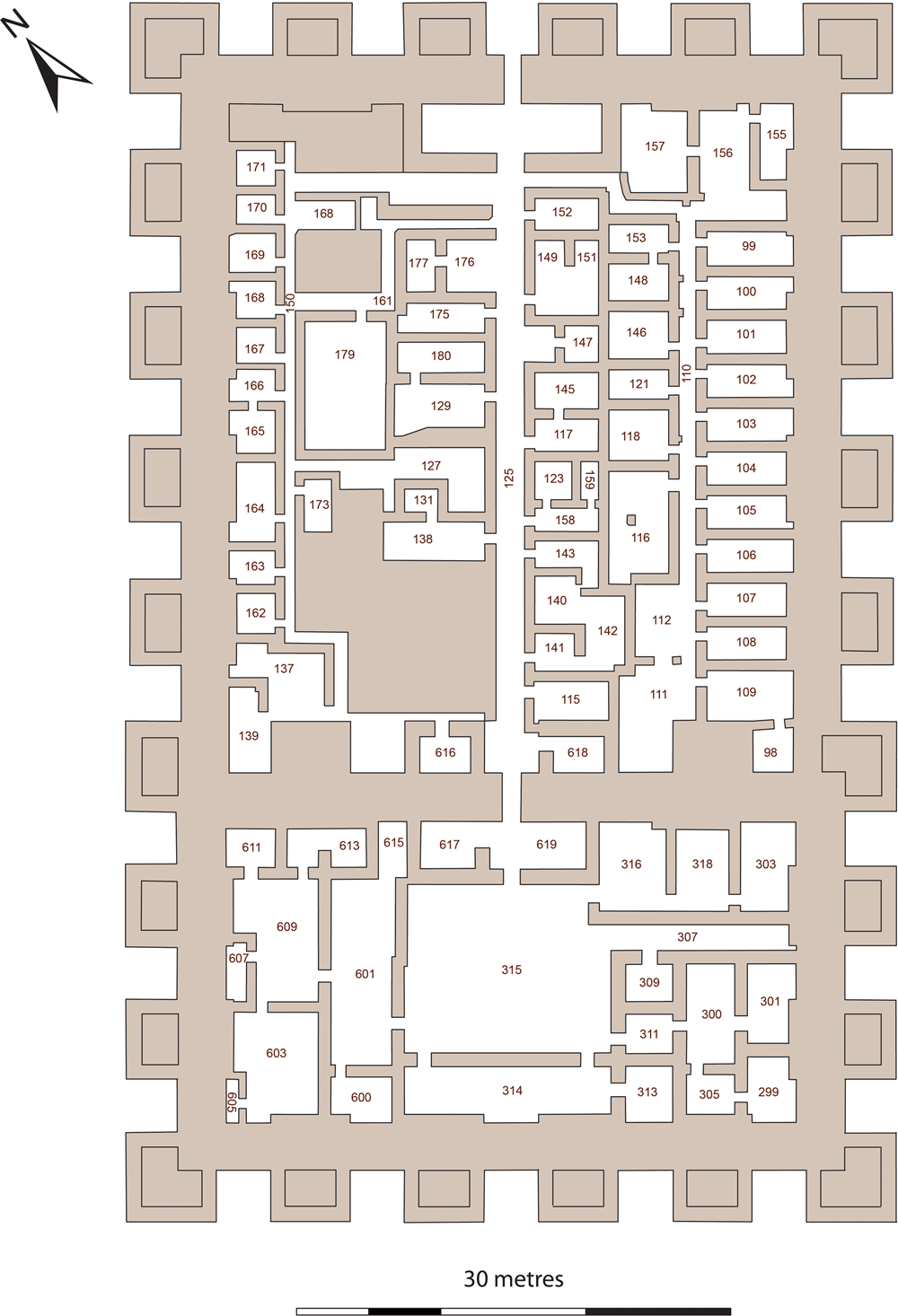
In considering the functions and nature of the Tell Khaiber building, basic space syntax analysis can highlight some key characteristics of the architecture's spatial organisation. Although the architectural plan recovered through surface scraping is impressively complete, there remain areas of uncertainty, including the positioning of some doorways, as well as areas where the walls were only partially visible or completely unrecoverable. As the mathematical processes of space syntax do not allow for such uncertainty, a slightly altered plan of the building (Fig. 11) was used, in which doorways which can be inferred with some certainty have been added, while areas where the access is not deducible or the walls are simply not preserved have been blocked off and discounted from the analysis. Consequently, there is more uncertainty than the exactitude of the quantitative results suggests.
Plan of Tell Khaiber building altered for use in space syntax analysis, with additional doorways hypothesised and areas where the division of space is unknown discounted.
Justified plan graphs
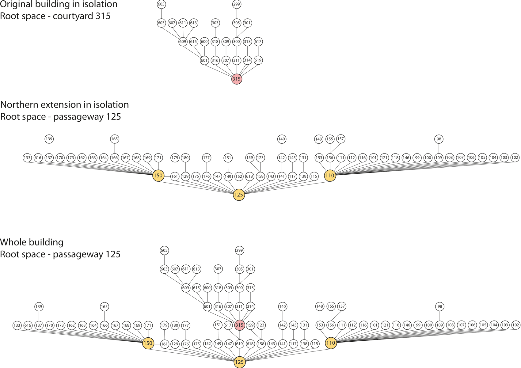
When the Tell Khaiber building is laid out as justified plan graphs (Fig. 12), schematically layering the rooms in terms of access steps from a ‘root’ space, the effect of the three passageways in the northeast extension becomes very apparent. For a building with 65 (included) spaces, the extension has just three layers of depth above the root space, when the root space is the central passageway, making the access graph extremely shallow. It is instructive to compare this to the smaller original building, which itself is rendered relatively shallow by its central courtyard, but with 24 spaces still has greater plan depth than the much larger northeast extension.
Justified plan graphs showing the original building (top), the northeast extension (centre) and the whole building (bottom) with their most integrated spaces as the root space. The three passageways of the extension are indicated in light grey (orange in online version), while the courtyard of the original building (315) is indicated in dark grey (red in online version).
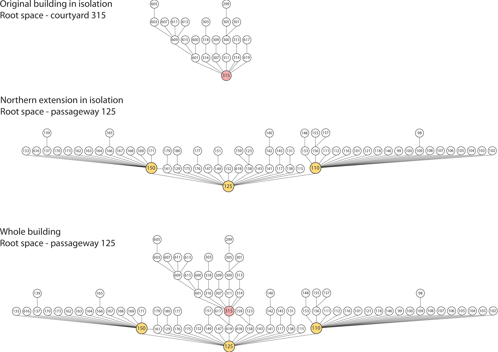
A further unusual and significant feature is that there are almost no circular routes in the building, rather the justified graphs show access routes branching to a series of dead ends. There are no links between rooms with the same depth. The only exception to this is the circular route provided by the short passage 161, which allows an alternative access to the northwest passageway 150. A further anomaly is the two doorways which both access the reception room 314 from courtyard 315; this is the only example in the building of such an arrangement.
In the terminology of space syntax, these properties render the Tell Khaiber building highly symmetric and nondistributed. If the northeast extension is considered in isolation, the building is a good example of what Hillier and Hanson call the ‘no neighbours’ model (1984: 132, 152–153), described as “a powerful way of achieving the greatest segregation of the greatest numbers” (ibid. 153). Relative asymmetry (RA) is a measure of the segregation of a space: the higher the relative asymmetry, the more isolated and private the space is; the lower the value, the more integrated and accessible it is. Relative asymmetry is calculated according to the method of Hillier and Hanson and ranges between 1 and 0 (Hillier and Hanson Reference Hillier and Hanson1984: 108–109; Ostwald Reference Ostwald2011: 451–453). RA numbers are all low in this range for the Tell Khaiber building due to the high degree of symmetry, i.e., the shallowness of the justified plan graph.
As might be anticipated, the most integrated space is the central passageway 125, which gives direct access to the two side passageways and to the original building, as well as more than a dozen rooms. It has the lowest RA value of 0.033 within the building as a whole. By comparison, passageway 110 has RA of 0.043, and the courtyard of the original building is slightly further segregated with an RA value of 0.055, these being the next most accessible, integrated spaces. The most isolated rooms are 605 and 299 in the furthest corners of the original building, with RA values of 0.138 and 0.142 respectively. The excavated barracks-type accommodation room, 101, has a moderate RA value of 0.066, as do all of the other accommodation rooms along the southeast passageway 110. All of the preserved rooms which open off the other flanking passageway, 150, have a very similar RA value, 0.070, to that of the known accommodation rooms (except for rooms 165, 166 and 139). This further supports the hypothesis that this rank of small rooms against the northwest wall had the same accommodation function as the corresponding rank of rooms against the southeast wall.
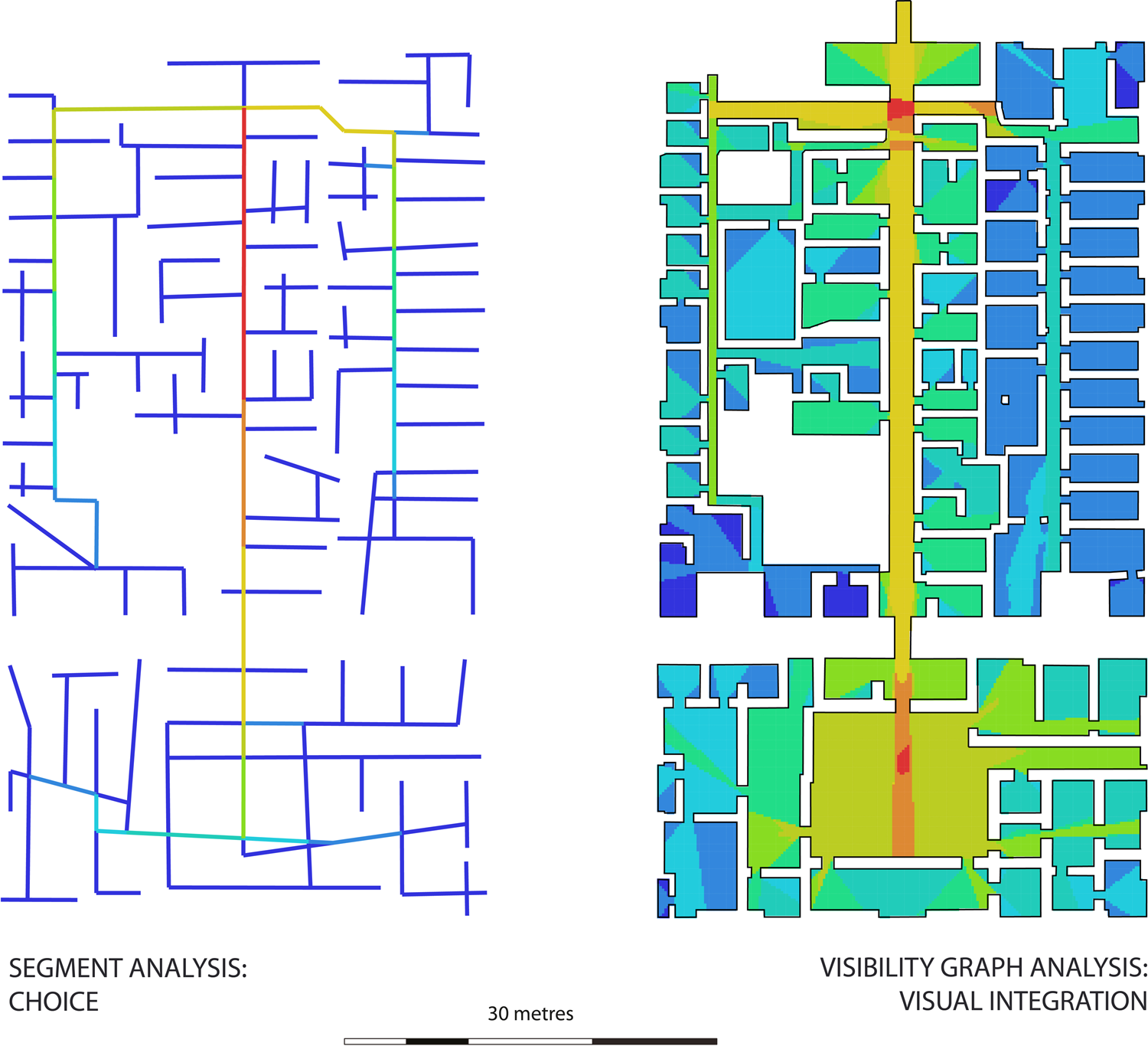
The segment analysis (Fig. 13, left) shows the building's pedestrian routes graded by connectivity, or the number of spaces to which each segment is closely connected, which is an indicator of encounter probabilities, meaning the likelihood of meeting other people in the space. Lighter greys (red/orange in the online version) indicate routes on which social interaction is likely, while darker greys (blues in the online version) represent more isolated routes. This type of analysis is usually applied to the road networks of urban landscapes, so its applicability to the fortified building may be a matter for debate. However, the passageways which control circulation in the extension make the layout similar in some ways to a street system, so the model has a degree of applicability. This analysis is less appropriate to the original building, which is organised around a courtyard rather than passageways. The choice of segment analysis highlights the primacy of the extension's central passageway in terms of the potential for social interaction, followed by the two flanking passages. The roofed spaces of the building are almost all coloured dark grey/dark blue, reflective of the segregation indicated by the justified plan graph; none of them constitutes through-routes to other parts of the building.
Spatial analyses produced using depthmapX software. Segment analysis (left) models the pedestrian routes of the Tell Khaiber building as a street system, with each segment shaded or coloured according to ‘choice’. The visibility graph analysis (right) is based on an overlapping grid of isovists, analysed here for visual integration, the mutual visual distance between points.
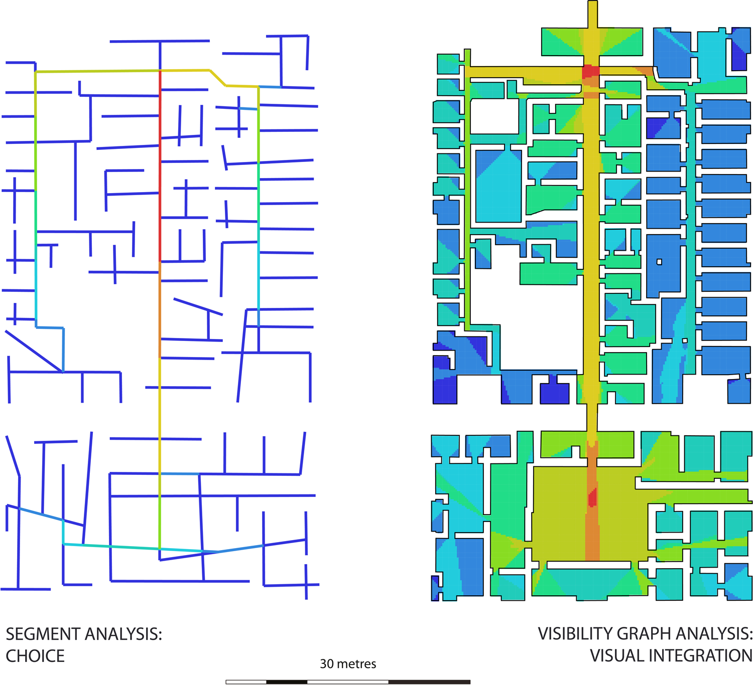
The visibility graph analysis (Fig. 13, right) illustrates the inter-visibility of space within the Tell Khaiber building. The lighter greys (warmer colours in the online version), indicating high visual integration, are concentrated along the central passageway through the northeast extension and in the courtyard of the original building. The two flanking passageways also have slightly enhanced visual integration, but their inter-visibility is undermined by their narrowness. It is notable that the original building generally has higher visual integration than the northeast extension, probably as a result of the subdivision of the extension into more, smaller spaces with shorter fields of vision than the somewhat larger spaces of the original building. It is notable that the least visually integrated spaces in the building, indicated in dark greys (blues in online version), are the small rooms proposed as accommodation.
Public and private
The spatial analyses presented above serve to distinguish the more public spaces of the Tell Khaiber building from the private areas. By public, it is not meant that these areas were accessible to anybody; access to the building itself and to areas within it, such as the original building, was likely to be restricted to certain people and according to circumstances. ‘Public’ here refers to the visibility and accessibility of the space for those who are admitted to and act within the spatial environment.
By all the metrics examined, the most public areas in terms of relative asymmetry value, the potential for social encounter and visual integration, are the central passageway 125 in the extension and the courtyard 315 in the original building. These areas are the focus of both accessibility and visibility in the building. The visibility graph analysis suggests that the rooms which lead directly off these public spaces are also of a more visually public nature than the other areas of the building. In considering the roofed spaces of the building, the two most visually integrated rooms are the chamber behind the main entrance gateway and rooms 619/617 at the entrance into the original building. Both of these spaces may have acted as vestibules for the regulation of access to the whole building and the original building respectively, making them public spaces which visitors were expected to access. The next most visually integrated rooms are those surrounding courtyard 315: room 316, the first room of the scribal suite 311, the proposed reception room 314, and large room 601. A more public spatial character fits with the proposed functions of at least the reception room, where guests would be received, and the entrance to the scribal suite, where frequent visitors might be expected on administrative business.
The two flanking passageways, 110 and 150, which give access to what are thought to be accommodation areas, appear to have a more private character. Although they are fairly accessible in terms of their RA values because they give access to so many spaces, their choice values are significantly lower than the central passageway, and their visual integration is particularly low. The fact that neither passageway leads to further areas, but rather terminates in a dead end, limits their connectivity. In terms of visual integration, the rooms accessed from these two passageways are the most private in the Tell Khaiber building. This is particularly marked for the rooms along passageway 110, which are known to be residential.
Functional analysis
Defence
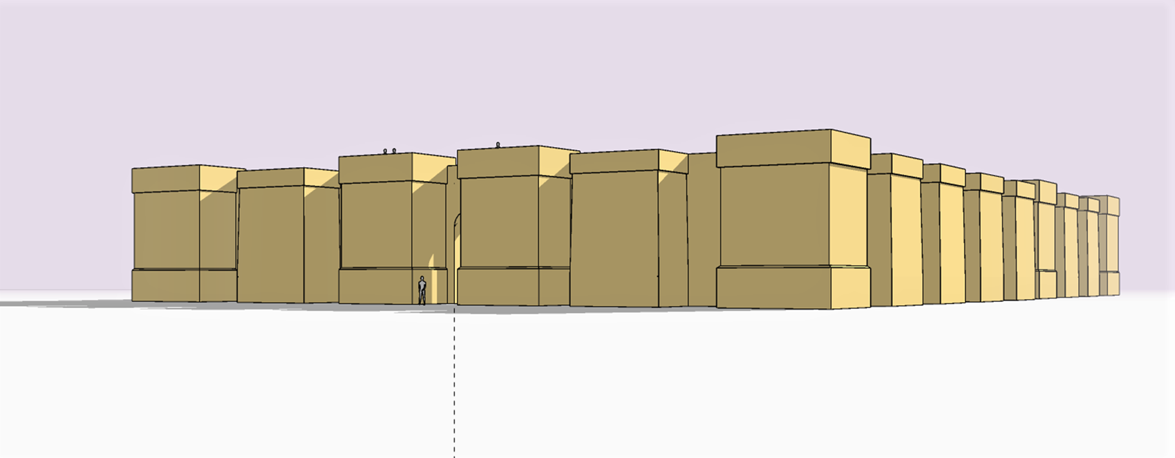
The most obvious architectural priority of the Tell Khaiber building is defence. The fortified nature of the structure is most apparent in the outer walls and towers, beginning with the visual effect of its exterior design, which is clearly intended to give an impression of strength and impregnability. The frequency and magnitude of the perimeter towers would have presented a façade of stark vertical lines, emphasised through much of the day by alternating stripes of bright brickwork and deep shadow, enhancing the visual impression of height. The single entrance, semi-concealed between two towers and on the more shaded northern side of the building, would have been shadowed for most of the day and only visible at all from a small range of angles (0-70° from N). This visually de-emphasised the one access point, effectively hiding it from almost all viewpoints, giving potential attackers the impression that the building was essentially a solid block with no way in (Fig. 14). The positioning of the gate on the most northerly facing side of the building may also have offered the advantage that during the majority of the day and year, attackers would have had to approach the entrance with the sun in their faces, while their target would have been silhouetted; a distinct disadvantage to the attackers and advantage to the defenders, for whom the approaching enemy would have been strongly lit and as visible as possible. Unlike on the southern side of the building, there are no traces of surrounding structures to the north of the main building. This may just be a quirk of preservation; erosion appears to have been more severe on the northern slope, but it may be that the area approaching the building's entrance was kept clear so that no structures could provide cover for attackers.
Reconstruction of how the exterior of the Tell Khaiber building may have appeared to a person approaching from the north at an angle 5° east of north so that the entrance gate is just visible. Mid-afternoon light conditions are modelled, eye level is estimated at 168 cm (5ft 6in), and the viewer is positioned 100 m from the entrance gate.
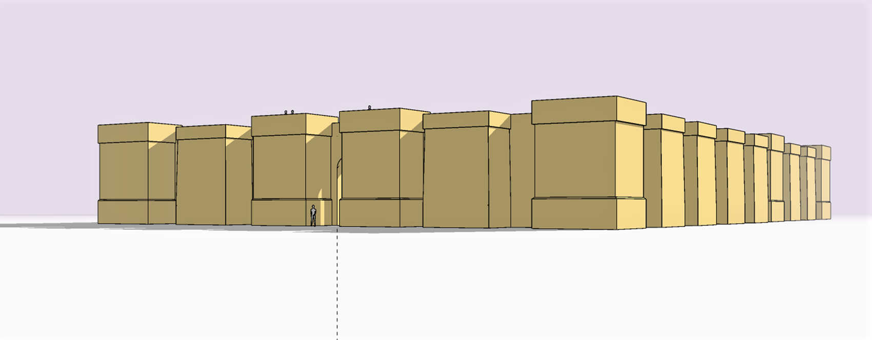
Tell Khaiber's perimeter towers have two main defensive advantages in addition to their formidable visual appearance. They make the scaling of walls with siege ladders much more difficult, as they allow defenders on adjacent towers to pour flanking fire onto any such attempt. The other effect of the large, close-set towers at Tell Khaiber is that they would have considerably strengthened the perimeter wall, acting as huge supporting buttresses. Whereas a straight, free standing wall of the width of Tell Khaiber's 3.30 m wide outer rampart might be expected to be structurally sound to a height somewhat over 6 m (Trzciński et al. Reference Trzciński, Zaremba, Rzepka, Bogusz, Godlewski and Szczepański2017), with the support of the 26 towers it may have been far higher. For the purposes of the reconstructions presented in this paper, the outer walls and towers are modelled at 8 m, but a height above 10 m is not improbable. The walls of the internal architecture are generally 60–80 cm wide, less than a quarter of the width of the outer walls, and could not have supported a similar height. There is no evidence for a second storey in the internal architecture, either in the form of stairs for access or as second storey collapse, indicating that the architecture within the walls probably did not exceed the approximately 3–4 m one-storey height suggested by the Old Babylonian period housing at Ur (Woolley and Mallowan Reference Woolley and Mallowan1976: 144, 152).
The suggestion of further defensive measures can be seen immediately inside the building's single entrance. Although the preservation of walls is poor in this area due to slope erosion, one traceable wall on the southeast side of the entrance is approximately double the width of the building's other internal walls. This indicates the presence of some kind of taller or more robust structure directly behind the gateway, perhaps providing a larger platform for defenders and equipment to be massed behind and above the gate, or possibly a structure allowing defenders to pour missiles down on any attackers who managed to breach the outer gate.
Collection and dispatch of agricultural produce
The texts recovered from the archive are from the later, expanded phase of the building and mostly date to the reign of Aya-dara-galama (c. 1500 b.c.). They show that at this time a major function of the building was the collection of agricultural products, primarily grain, and the onward dispatch of these to ‘The Palace’. Knowing that the users of the building at Tell Khaiber collected relatively large quantities of grain, it was expected that the building would incorporate substantial storage areas, but this does not appear to have been the case. Other than the inference that the subfloor vaults indicate an area of specialised storage in the first phase of the original smaller building, there is no evidence for extensive dedicated storage areas at Tell Khaiber. It therefore appears likely that the collected agricultural products were not stored for any significant time but rather dispatched onward as soon as possible. The palace to which Tell Khaiber sent its grain was recently identified as the source of an unprovenanced palatial archive in the Schøyen collection (Boivin Reference Boivin2018: 71–72), first published by Stephanie Dalley (Reference Dalley2009), but the location of this palace is still a matter of conjecture.
Accommodation
Instead of large-scale storage, the northeast extension seems to provide extensive accommodation for personnel within the protection of the fortified walls of the building. The usual Mesopotamian architecture of rooms arranged around courtyards was replaced by a more compact arrangement organised around three parallel passageways, providing rows of barracks-like accommodation down the two long sides of the building. The passageways acted almost as streets, and the whole northeast extension was organised more like a small compact settlement than a second millennium b.c. building interior. The apparent need to maximise accommodation may in part be explained by the defensive function of the building; a fortress needs a garrison. Evidence for the presence of troops is found in the cuneiform archive, which mentions two squads of ten royal auxiliary troops drawing rations.
The compact packing of residential space into the northeast extension, however, suggests that the accommodation may have been for more than a garrison. The scanty remains of additional structures outside of the main building at Tell Khaiber (Campbell et al. Reference Campbell, Moon, Killick, Calderbank, Robson, Shepperson and Slater2017: 23) suggest the possibility that the vast majority of the settlement's population, civilian as well as soldiery, resided inside the fortified building, or at least could be crammed in if the settlement was threatened. This would again suggest a strong prioritisation of defence, with most of the settlement's functions and almost all of its personnel situated safely inside the fortified walls of the main building, despite this necessitating what were clearly very cramped living conditions.
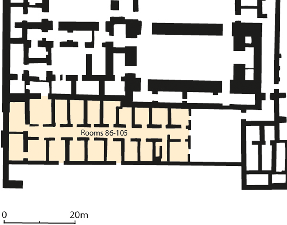
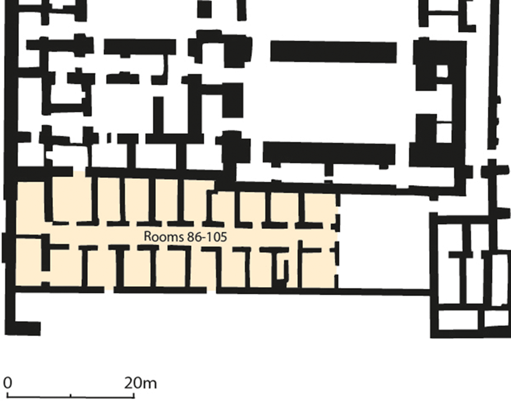
A strong architectural parallel for the barracks-style accommodation at Tell Khaiber can be found in the Palace of Zimri-Lim at Mari, which predates the Sealand occupation of Tell Khaiber by a couple of centuries. Although the rest of the palace is organised conventionally around a series of courtyards, rooms 86–105 near the southwest limit of the building form two ranks of small rectangular rooms opening onto a central passageway (Fig. 15). This arrangement is very similar to that found in Tell Khaiber's northeast extension, and the rooms at Mari are of similar, although slightly larger, dimensions. Like those at Tell Khaiber, the rooms along the passageway at Mari are interpreted as being residential, for the accommodation of minor personnel (Margueron Reference Margueron1982: 340–342).
The southwestern quarter of Zimri-Lim's Palace at Mari. Along the southern edge, two ranks of residential rooms are arranged along a straight central passageway. To the north of this area the rooms are arranged around courtyards, adhering to conventional Mesopotamian spatial organisation.
Estimating the number of people who could have been accommodated inside the Tell Khaiber building is of course subject to numerous unknowns, but some informed speculation is possible. Each of the long narrow rooms down the south east side of the northeast extension could easily sleep ten adults, perhaps the ten-man squads of troops mentioned in the archive, meaning that the eleven rooms could accommodate as many as 110 individuals without too much trouble. Most of the rooms along the north west side are smaller and could sleep perhaps four or five comfortably, with the larger rooms closer to ten, adding perhaps another 60–70 people. The excavation of suite 140–143 suggests that at least some parts of the central blocks were also domestic. An estimate of 200 individuals in the northeast extension may therefore be considered to have some basis in the architectural remains. The southern part of the building seems likely to have been less densely populated, as it contained the official and administrative areas, but it may reasonably have accommodated another 20–30 people. The total population of the building may have been far higher if, for instance, parts of the plan had a second storey, or if roof space was used for sleeping. The excavated rooms may also have been significantly more or less densely populated than suggested above, affecting the estimated total.
Palatial functions?
As discussed above, the formal layout of the southern area of the building, at least in its later form, suggests that it may have partly functioned as an elite residence for a governor or senior administrator, with some efforts made towards creating a grand built environment. However, the excavated remains indicate that the Tell Khaiber building was far from palatial. There are very few high-status goods of any kind from the Sealand levels, and the pottery assemblage is overwhelmingly utilitarian (Campbell et al. Reference Campbell, Moon, Killick, Calderbank, Robson, Shepperson and Slater2017). In terms of the architectural remains, the building is entirely made of unbaked mudbrick with no evidence for the use of more costly baked brick or stonework for any architectural elements. The indications of higher status – the courtyard trees, the row of mudbrick pedestals and the use of coloured plaster – all consist of locally available materials attainable at little expense. The courtyard's rough stone basin is the only significant indication of imported ‘luxury’.
Another notable absence from the archaeological and architectural record is cult. Votive finds are limited to a handful of clay plaques and a single fragmentary figurine dedicated to the goddess Gula. No mention is made in the cuneiform archive of any religious personnel, despite extensive lists of other professionals, and no temple or shrine was identified within the architectural plan, although this absence is far from conclusive given the limited areas excavated.
The general impression is that the building at Tell Khaiber is of an overwhelmingly utilitarian nature, with little or no indications of elite status or religious practice. The building is primarily military and administrative.
Political context
Relatively little is known about the political history of the Sealand Kingdom because the disintegration of the Old Babylonian state, out of which the Sealand emerged, was accompanied by a depopulation of major settlements and a sharp reduction in scribal activity (Stone Reference Stone, Young and Levine1977). At least this is the case at the large urban centres which have been the main focus of excavation. Until recently, the only sources were texts written about the Sealand Kingdom by the rival Babylonian state, often authored long after the facts (Boivin Reference Boivin2018: 20, 93). These suggest that during the early years of the Sealand state the boundary between Sealand control and Babylonian control was fluid and changed rapidly as military advantage ebbed and flowed. Sealand power seems to have reached at least as far as Nippur by late in the reign of Šamšu-Iluna, before receding again under the more aggressive Babylonian tactics of Abī-ešuh (Boivin Reference Boivin2018: 89–95).
Abī-ešuh appears to have begun a process of militarisation of the disputed border area, which involved the construction of fortresses as a bulwark against further Sealand incursions, as implied by texts originating in one of these forts (Van Lerberghe et al. Reference Van Lerberghe, Kaniewski, Abraham, Guiot and Campo2017). The following king, Ammiditana, also records the construction of forts (Boivin Reference Boivin2018: 113) and letters of his successor, Ammiṣaduqa, mention a series of fortresses out in the countryside, not connected to urban centres (Richardson Reference Richardson and Van Soldt2005). These appear to be recent foundations of the crown, some bearing the names of these later Old Babylonian kings; Dūr-Ammiditana and Dūr-Ammiṣaduqa, for example. The apparent stabilisation of the border and reduction in open warfare indicated by the texts during the mature phase of the First Sealand dynasty (Boivin Reference Boivin2018: 115) suggest that both sides adopted a defensive stance, aimed at protecting their territory from incursions rather than at territorial expansion. Although textual evidence is lacking from the Sealand side, it seems plausible that this relative equilibrium was reached by the Sealand state constructing a corresponding network of fortresses in the border region to counter those known to have been constructed by the Babylonians.
Related architectural traditions
While there are no direct architectural parallels for the highly unusual Tell Khaiber building from Mesopotamia in the second millennium b.c., there are architectural traditions both preceding and following the Sealand Kingdom which bear some similarities in nature and function. There is reason to connect the later Old Babylonian fortresses described above with the pre-existing second millennium b.c. tradition of dimtu settlements known largely from written sources. Although the precise form of dimātu is unclear and may have changed over time, their key characteristics included a rural location away from urban centres, a large fortified building of some kind, and ownership or control over an area of agricultural land (Koliński Reference Koliński2001: 103–104). This obviously coincides well with the apparent features of the Tell Khaiber building, being an isolated, fortified structure with administrative control over an area of agricultural production. Dimātu, however, do not appear to have been serious fortresses, as indicated by texts which describe the conversion of dimātu into true fortresses. The Dimtu of Enlil is recorded as having been changed into a fortress by Šamšu-Iluna, for example (Koliński Reference Koliński2001: 27).
After the First Sealand Dynasty, a related tradition of dunnu settlements is present during the Middle Assyrian period. Similar to dimātu in their fortified character and control of agricultural land, dunnu were primarily military posts containing soldiers and were related to the control of border areas (Koliński Reference Koliński2001: 32).
The only settlements tentatively identified as a dimtu and dunnu respectively are Tell Faḫar (Koliński Reference Koliński2002) and the Middle Assyrian structure at Tell Sabi Abyad (Akkermans et al. Reference Akkermans, Limpens and Spoor1993; Düring Reference Düring2015). Both of these northern Mesopotamian settlements have features in common with Tell Khaiber, although their architectural forms bear little resemblance to the symmetrical, regular plan of the Tell Khaiber building. Both Tell Faḫar and Tell Sabi Abyad began as small forts and were later expanded, just as at Tell Khaiber. Both are heavily fortified with thick walls, and Tell Faḫar's later plan includes seven irregular mudbrick towers. However, the fortified buildings at both these sites are much smaller and far more irregular than that at Tell Khaiber, and neither has the sort of accommodation provision seen in the Sealand building. Although the Tell Khaiber building may owe part of its functional concept to the dimtu/dunnu model of a fort controlling agricultural production in a disputed border region, the symmetry and scale of the Tell Khaiber building displays significant variance from these architectural traditions.
Conclusions
The Sealand building at Tell Khaiber is a type of structure not previously encountered in the region. It appears to have been founded as a small fort, perhaps a military outpost intended to provide a Sealand foothold in a disputed area, laying claim to an agriculturally productive area on the Ur channels of the Euphrates. As the Sealand state solidified its power and territory, the Tell Khaiber building was greatly expanded, becoming a contained, fortified community, the main functions of which were military defence and the collection of agricultural production from the surrounding land on behalf of the Sealand administration.
The architectural layout of the Tell Khaiber building is of a formal, planned design rather than having an organic, evolved character. This suggests a state-founded building with a defined role in a centrally controlled system. In architectural terms, the highest priority is given to the defence of the structure, with ease of access and the comfort of living conditions subservient to defensive needs. Considering materials and labour, a disproportionate amount of the construction cost went into the defensive walls and towers compared to the space they enclose. The perimeter of large, closely spaced towers has no known parallel within second millennium b.c. Mesopotamian architecture and seems to represent an extraordinary effort of fortification for the modest scale of the building.
The interior plan of the building has two distinct parts. The original part was the southern block, which after the addition of the large extension appears to have hosted executive and administrative functions, as indicated by the scribal suite and the presence of a formal reception room. The northeast extension appears to be focused on the accommodation of a very large number of personnel in the limited available space. Spatial analysis suggests that the system of passageways along which the rooms are arranged was intended to provide the maximum possible privacy for the cramped accommodation areas, while minimising the unbuilt space inside the walls.
The fortified building at Tell Khaiber may represent the Sealand response to the known construction of fortresses by the Babylonian state in the border area between itself and the Sealand Kingdom. The mutual construction of defensive strongholds, making territorial gains by either side very difficult, is possibly the cause of the apparent stabilisation of the Babylonian-Sealand border during the height of the Sealand state when the building at Tell Khaiber appears to have been active. If this is the case, Tell Khaiber may be just one of a series of similar fortified Sealand settlements which are yet to be identified. This would represent an intriguing example of the development of border infrastructure between two second millennium b.c. Mesopotamian states.