


Introduction
How do we know a mountain? Do we know it by memorizing the poems carved on its rocks and the names of its pine trees, or by understanding its position on the globe? Do we know it by reading descriptions in texts, or by capturing its image in photographs? Do we know a mountain by recording its elevation above sea level, or by supplicating the gods that call the mountain home? Do we need to know a mountain's nationality or can our knowledge about mountains transcend the political?
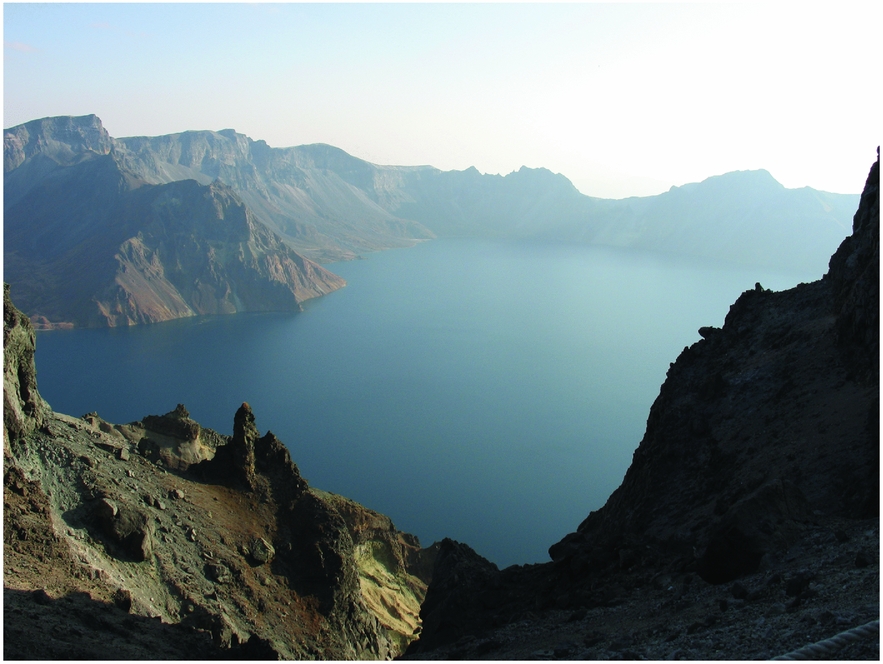
These questions about the creation of knowledge animate my enquiry into one particular mountain in northeast Asia, known most often as ‘Paektusan’ in Korean and ‘Changbaishan’ in Mandarin Chinese.Footnote 1 Mount Paektu/Changbai is an extraordinary mountain in an extraordinary place. A view of mainland northeast Asia in Google Earth clearly shows the mountain's white-capped form rising like a solitary giant from a sea of green forest at the top of the Korean peninsula. Measuring over 9,000 feet (approximately 2,743 metres) above sea level, Mount Paektu/Changbai is the highest peak in the region, but at one time it was much taller. Known today for its placid beauty, the mountain is actually an active stratovolcano. Scientists estimate that around 1,000 CE, the volcano experienced a catastrophic eruption considered to be one of the largest volcanic events in historic times, with an estimated Volcanic Explosivity Index (VEI) of seven (a number dubbed ‘Super-colossal’, one rank below ‘Apocalyptic’). This ‘Millennium eruption’ blew off much of the cone of the volcano, reducing its height by as much as a third and sending a Plinian plume of smoke and ash an estimated 15 miles (24 kilometres) into the stratosphere. A brilliant blue caldera lake, dubbed ‘Heaven Lake’ (Ch’ŏnji in Korean, Tianchi in Chinese), lies in the crater at the centre of the mountain (see Figure 1). Water from the lake plunges over the northern rim in a spectacular waterfall, forming the beginnings of the Songhua River in the valley below. Jagged peaks tower above the lake, silent reminders of the extraordinary violence that created the mountain's stunning landscape.Footnote 2
Heaven Lake, from the summit of Mount Paektu/Changbai.

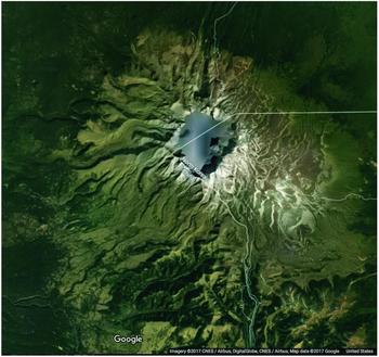
Adding political boundaries to the Google Earth image reveals another important fact about the mountain: the national border between China and North Korea runs through the middle of its peak, bisecting Heaven Lake (see Figure 2). Like many significant mountains around the world, including Mount Blanc, Ojos de Salado, and Mount Everest, Mount Paektu/Changbai is split between different political entities.Footnote 3 This border, however, is particularly fraught. A hike around the lake is a political impossibility: the vast majority of visitors to the mountain today (including those from South Korea) must approach the mountain from its northern ‘Chinese’ slopes and avoid the peaks on the North Korean side. While tourists cautiously trek along the mountain's designated paths, Chinese and South Korean scholars, and political leaders in capital megacities hundreds of miles away have passionately debated the legacy of the mountain. Each side vies for the right to represent the mountain in international arenas, and each side claims that evidence from history and culture support their polity's claim to the mountain.Footnote 4
Satellite image of Mount Paektu/Changbai, showing the People's Republic of China/Democratic People's Republic of Korea border.

If we extend our consideration of the mountain several centuries back into the past, then Mount Paektu/Changbai appears situated not just on a fraught border between two countries, but on the contested edge of multiple Eurasian empires—including the Qing, Romanov, Japanese, and, in a curious way, the British empire. Mount Paektu/Changbai, then, is an intriguing example of a natural formation that has been an object of curiosity and desire for multiple intersecting polities from the early modern to modern eras. What sort of strategies were deployed to create knowledge about the mountain across time? And how was knowledge about the mountain related to the multiple political projects that laid claim to the region?
To address these questions, this article examines narratives of ascents of Mount Paektu/Changbai written by elites who climbed the mountain from the seventeenth to the early twentieth centuries, including a Manchu explorer, a Chosŏn mathematician, a Chinese photographer, a British adventurer, a Japanese ecologist, and a Korean historian. Focused attention on the ways these climbers engaged with the terrain of the mountain opens new windows on the role of space in the production of knowledge about nature. As scholars such as Steven Shapin and David Turnbull have noted, knowledge is not a ‘view from nowhere’, but is instead ‘constructed at specific sites through embodied engagements’.Footnote 5 Many previous examinations of the mountain have considered the role of history, myth, and border-making in the construction of knowledge about it, but few have considered the role of the mountain itself in the formation of this knowledge.Footnote 6 This article puts the physical presence of Mount Paektu/Changbai at centre stage, and examines how its physical/spatial characteristics—including but not limited to its volcanic activity, immense size, and location within a specific terrain—served to shape, limit, and inspire the understanding of those who climbed it.Footnote 7
Putting the mountain at the centre of inquiry not only allows us to understand the interaction between humans and their environment, but also facilitates examination of human-to-human interactions. A spatial focus reveals Mount Paektu/Changbai as a ‘contact zone’, described by Mary Louise Pratt as a site where people from different origin-points ‘meet, clash, and grapple with each other’.Footnote 8 Recent scholarship in the history of science has demonstrated that non-Western participants in scientific explorations were far more than subordinate guides, and instead were important participants in the creation of what has previously been seen as Western knowledge.Footnote 9 Encounters on Mount Paektu/Changbai confirm the importance of local guides, but diverge in a significant way: the first explorers who produced narratives of the climb in the seventeenth and eighteenth centuries were not Westerners, but northeast Asian elites who journeyed to the remote mountain from political centres hundreds of miles away. These men brought with them tools of scientific investigation, and their reverence for the mountain was tinged with Confucian scepticism. Their local guides—men who might be recognized as ethnically similar compatriots—often possessed a strikingly different knowledge of the mountain. Drawn from populations who lived in close proximity to the volcano, they viscerally sensed the mountain as a sentient being, a god that rewarded good or punished evil through the visible agency of wind, storms, and fire. Returning to Seoul or Beijing, elites created a hybrid form of knowledge, weaving together belief in the mountain as a sentient being with science in order to bolster projects of political consolidation.
This hybrid knowledge became embedded in emerging global networks of science and power in the age of late empire. By the end of the nineteenth century, the spatial and political landscape centred on Mount Paektu/Changbai became more complex as representatives of Great Britain, Tsarist Russia, and Imperial Japan climbed the mountain. The presence of these empires altered both the positioning and the nature of northeast Asian elite knowledge of the mountain. As the mountain itself became nested within spatially expanded layers of power, metropolitan Asian knowledge was made ‘local’ vis-à-vis more distant power structures. By the twentieth century, this knowledge of the mountain would become righteously ‘indigenous’, an emotionally charged locus for sovereignty and national resistance. Spatial considerations of journeys to Mount Paektu/Changbai complicate our understanding of the relationship between knowledge about nature and projects of state-building at multiple levels.
My goal in examining Mount Paektu/Changbai, then, is not to make a pronouncement about the passionately contested boundary question, nor do I seek to determine to whom the mountain really belongs. Instead I follow the traces of footsteps over the terrain of the mountain in order to illuminate the ‘conjunctural tangle of science, space, and affect’ that informed the production of politically charged knowledge.Footnote 10 I undertake this exercise, mindful of boundaries but not dictated to by them, in the hopes that spatial history can generate productive ways of thinking about environment, empire, and nation in northeast Asia.
From the deer hunter to the emperor: locating Golmin šanggiyan alin
In the spring of 1677, the Kangxi emperor (r. 1661–1722) of the Qing dynasty (1644–1912) proclaimed a troubling problem. The Manchu's northeastern homeland was increasingly becoming the site of conflict and confusion.Footnote 11 Yet the problem Kangxi pondered on this day was geographical: no one at his court in Beijing seemed to know the exact location of Golmin šanggiyan alin, the Long White Mountain (in Chinese, Changbaishan). Golmin šanggiyan alin was where a divine spirit had come down from heaven in the form of a magpie and impregnated an earthly woman, who then gave birth to the hero Bukuri Yongson, the progenitor of the imperial Aisin Gioro clan. This foundation story, though of murky provenance and possibly of fairly recent vintage, was featured at the beginning of histories that detailed the rise of the Manchus from scattered Jurchen tribes in northeast Asia to become the rulers of the mighty Qing empire.Footnote 12 How could it be that no one at court had ever set foot on the mountain? To remedy this problem, the emperor dispatched an imperial clansman named Umuna on an expedition to ‘visually inspect’ Golmin šanggiyan alin, in order to facilitate the ‘judicious execution of the sacrificial rites’.Footnote 13
Scholars have noted that Kangxi sought to monopolize the region's rich natural resources for his own court and generate cartographic data, but the Umuna expedition had multiple meanings.Footnote 14 Throughout East Asia, for millennia certain mountains had been revered as powerful, numinous entities. Within China proper, five mountains became officially codified as ‘sacred peaks’, one for each of the cardinal directions, and one for the centre, with the eastern Mount Tai (Taishan) the most esteemed mountain of all. Imperial courts throughout the dynasties sponsored official rites honouring these mountains, performing dominion over their imperial terrain while at the same time accessing the mountains’ spiritual power.Footnote 15
Kangxi sought to bring Golmin šanggiyan alin into the pantheon of sacred mountains through empirical observation. Influenced by Chinese Practical Learning studies (shixue) and tutored in mathematics and astronomy by European Jesuit advisers, empirical evidence had become a central element in Kangxi's approach to ruling the Qing empire. Whether manipulating cones and spheres for a geometric proof, wielding astrolabes to plot the heavens, or ordering mapping surveys of his entire realm, Kangxi used direct observation of nature as a way to perform his power.Footnote 16 In seeking this mountain, Kangxi sought more than economic control of a geological formation—he was also in search of a god. Kangxi desired empirical evidence of the mountain's spiritual power and sent Umuna on a journey to bring back proof.
A spatial consideration of the narrativeFootnote 17 of Umuna's journey helps us understand the remove between the urban court-Manchus and the diverse, rugged denizens of the northeastern borderlands.Footnote 18 Umuna's team departed from Beijing in early June of 1677, and travelled northeast for 600 miles (966 kilometres) before arriving at Girin Ula, a Manchu military outpost located 200 miles (322 kilometres) northwest of the mountain. At this rough-hewn frontier fort, they sought a local guide with knowledge of Golmin šanggiyan alin's whereabouts, but no one had direct experience of the mountain. As they were consolidated into the Eight Banner military machine through conquest and alliance over the course of generations, families had been relocated into garrison towns, leaving home settlements near the mountain a distant memory. Only one old hunter-forager named Niyahan Daimubulu had a vague sense of the distance the mountain lay from his ancestral village near the Ehe Neyen River at the foot of the mountain. While he himself had never climbed the mountain, he had heard his father say, ‘If you go hunting at the foot of Golmin šanggiyan alin and carry the deer home on your shoulders, it takes three nights on the road, and by the fourth day you can make it home.’Footnote 19 The Beijing team had to translate this fragment of embodied local knowledge—a sense of distance and direction measured by the heavy steps of a tired hunter, recalled decades later—into forms that could guide the journey of the imperial expedition. Umuna further enlisted the guidance of local manpower: the Jilin-born Sabsu, a colonel in the Ula garrison who would later become famous for defeating the Russians at Albazin; Ehei, the commander of the hunters who worked in the Ehe Neyen region, and the hunter Kara, who led the way for the expedition.Footnote 20 While none of these men had set foot on the mountain, they organized logistics and plotted both riverine and land routes in its general direction.
Under the command of Sabsu, the overland expedition set off in a southerly direction towards the mountain, but it was travelling blind. Umuna's narrative emphasizes that it was impossible to see their goal from the ground. Dense forests that went on ‘as far as the eye could see’ obscured lines of sight, and the mountain cloaked itself in clouds and mist.Footnote 21 Before we dismiss these details as mythologizing narrative, we must consider that the very physical embodiment of Mount Paektu/Changbai makes it truly difficult to see. On the approach from the north, the massive basalt shield of the stratovolcano rises very gradually from a height of around 700 metres above sea level to a height of 1,000 metres at the base of the cone, producing an incline of only 2 per cent over the course of 60 miles (96 kilometres). Much of this long, low slope is covered in dense forest consisting of mixed deciduous and broadleaf evergreen trees, which give way to tall Korean pines as the altitude increases.Footnote 22 From this extended base, the cone of the volcano rises to a relatively modest height. The mountain was known as ‘Long White’ in Manchu and Chinese for a reason: the Millennium eruption considerably reduced the cone of the volcano, leaving the mountain with a low-slung vertical profile in relation to its broad horizontal expanse. As a result of these features, as the traveller approaches the mountain, it stubbornly refuses to appear in view. Indeed, until one ascends to the peaks and gazes down at the spectacle of Heaven Lake, the mountain evades visual comprehension, giving, in the words of one European climber, ‘the impression of something broad and confusingly arranged’.Footnote 23
Not only does the geometry of the mountain and its surrounding environment block lines of sight, the climate also mitigates against clear vision. The northern slopes of Mount Paektu/Changbai and the surrounding Changbai mountain range form a barrier that stalls the advance of the seasonal monsoon as it moves from southwest to northeast across East Asia. The region experiences heavy snowfall in the winter months and perpetual drizzle the rest of the year: data gathered in the late twentieth century show precipitation at the mountain's peak as high as 70 inches (178 centimetres) per year, roughly equivalent to the average rainfall in Kolkata in India and Guangzhou in China.Footnote 24 The gradual rise of the mountain, tall trees, low clouds, and even the curve of the earth, all conspire to conceal the mountain from the gaze of those who seek it.
According to Umuna's account, it was only through the power of the mountain itself that the expedition succeeded. Sensing they were near, but surrounded by a dense fog, members of the expedition knelt and read the imperial orders. As if in response to the edict, the clouds dispersed and the mountain allowed itself to come into full view, its white peaks capped in glory. The awe the men felt at seeing the mountain did not deter them from their imperially mandated task of ‘visually inspecting’ the mountain, and Umuna's report includes some description of the mountain's topography along with estimates of height of the peaks and the circumference and depth of the caldera lake. As the expedition descended from the mountain, the mountain then withdrew itself from sight: ‘We turned to gaze once again at where Mount Changbai had been, but suddenly it disappeared from their sight, enveloped by clouds and mist.’Footnote 25
With the return of the expedition to Beijing, the emperor was now in possession of eyewitness reports both of the mountain's location and of its miraculous powers. Kangxi elevated the mountain to an imperial object of worship, but simultaneously suppressed the ability of his subjects to see it. As early as the 1650s, the Qing court prohibited movement east of the Liao River valley, making the area for hundreds of miles around Mount Changbai officially off-limits to Han Chinese migrants. This proscription is generally linked to the Manchu desire to monopolize the economic and strategic resources of the northeast, but the boundary could also be seen as an attempt to make space spiritually and environmentally ‘pure’ by rendering it invisible and inaccessible, part of what Jonathan Schlesinger has felicitously termed ‘the Qing invention of nature’.Footnote 26 The spectacular contours of the mountain, the existence of a stunning crater lake, and the waterfall source of the Sungari River were known and frequently alluded to in texts through stock phrases by elites across the empire, but the mountain was not to become an object of direct experience for metropolitan elites—for them, Golmin šanggiyan alin remained a mountain of the mind.
While Kangxi tried to keep the mountain hidden, he himself commanded both distal and proximal knowledge about it, and used this knowledge to make a very specific political statement about his empire. While Kangxi was an enthusiast for new map-making technologies from the West, at times he put maps (and the new modes of aerial-view visuality they inspired) to work in surprising ways. Footnote 27 In December of 1709, shortly after the return of the Jesuit surveying expedition to Manchuria, the emperor penned a statement that reoriented the sacred geography of the Qing, producing what Stephen Whiteman has termed ‘the auspicious empire’.Footnote 28 In a long and technically brilliant essay, the emperor established that the ‘dragon vein’ of Taishan, the premier sacred mountains of China proper, actually originated with the Manchu sacred mountain of Changbaishan.Footnote 29 In East Asian cosmography, the ‘dragon vein’ was thought of simultaneously as the visible elevations of land formations (such as mountain ranges) as well as the invisible qi energy embodied within those formations. Kangxi proudly touted his command of direct knowledge of the mountain:
WE have studied with precision the earth's form, deeply researched the [qi] channels of the earth, dispatched men who have navigated the seas and conducted geographical surveys. WE therefore know that the Dragon Vein of Mount Tai actually originates at Mount Changbai.
In a visually vivid essay, written from a bird's-eye perspective of terrain, Kangxi traced the progress of the dragon vein from Mount Changbai, following its main branch southwest down the Liaodong peninsula (while another offshoot extended southeast into Korea). Continuing southwest, the dragon vein plunged under the Bohai gulf and re-emerged on the Shandong peninsula, where it finally accumulated its energies and became Taishan, ‘its towering peaks twisting majestically into the sky, first among the five sacred mountains’.Footnote 30
For millennia, Mount Tai had been esteemed as the most sacred mountain in China. But now Kangxi demonstrated what he saw as the natural coherence of his empire and the superiority of the Manchu over other peoples in East Asia. He did this by constructing a hybrid form of knowledge, one that combined the standardized vision and number of geographical surveys with the sacred power of sentient natural forms confirmed by direct experience of the mountain. Kangxi subjected the environment of his empire to the rational dictates of number, not in order to remove its valences of enchantment, but in order to enhance them. Kangxi wanted both accuracy and miracles, and in translating the footsteps of the deer hunter into both maps and state-sponsored worship, he created a hybrid tool for political consolidation.
Local knowledge in the eyes of the metropolitan: Chosŏn journeys to Mount Paektu
Long before Umuna's expedition, Mount Paektu had occupied an important place in the pantheon of sacred mountains of Korea. Legends recorded in the thirteenth century marked the mountain as the birthplace of Tan'gun, the mythical founder of the ancient kingdom of Kojosŏn (ended 108 BCE) which had once occupied much of Manchuria and part of the Korean peninsula. The mountain was also revered as the birthplace of the ruling house of Koryŏ, a unified kingdom that controlled the entire Korean peninsula from 918 CE to 1392 CE. Centuries before the Kangxi emperor made his geomantic claims about the connection between Changbaishan and the mountains of China proper, the Koryŏ court conceptualized Mount Paektu as the originating point of the Paektudaegan (the Great Paektu Range), the ‘dragon vein’ whose energies sustained the unified kingdom.Footnote 31
Yet the area around Mount Paektu had long been a site of conflict between Korean states and other inhabitants of northeast Asia. Generations of warfare between Jurchens and Koreans in the mountainous borderlands stabilized only after traumatic invasions of Chosŏn Korea by the ascendant Qing army in the early seventeenth century and the subsequent reluctant recognition of Qing suzerainty by the Chosŏn court in Seoul.Footnote 32 In spite of the end to hostilities, competition over natural resources (sometimes resulting in murder) continued in the borderlands. To settle the chaos, in 1712, the Kangxi emperor dispatched an emissary, Mukedeng, who climbed Mount Paektu and established border markers well to the south of its slopes. This move was deeply resented by the court in Seoul, but it also reinvigorated Korean interest in the physical manifestation of the mythical mountain. After 1712, creating concrete knowledge about Paektusan became a central issue in defining and defending the entire kingdom. Footnote 33
Throughout the eighteenth century, Chosŏn's Sirhak (Practical Learning) scholars produced a flood of geographical treatises that probed the position and significance of Mount Paektu.Footnote 34 These scholars participated in the same global intellectual exchanges that inspired the Practical Learning trends in China, including technologies of astronomy, mathematics, and surveying which we have already seen influencing the Kangxi emperor. While some Sirhak scholars perused maps and historical documents in their studies, other elites journeyed northwards and climbed the mountain themselves, producing the first extensive, detailed eyewitness narratives of journeys to the mountain, not only in Korean history, but in the history of the world.Footnote 35 These narratives not only reveal urban-based scholars' experience of the mountain's terrain, but also highlight interactions between metropolitan elites and the ordinary residents of the mountain region who served as their guides.
One of the first Korean narratives of a climb up Mount Paektu is Hong Se-t'ae's ‘Paektusan gi’, a narrative of the 1712 Mukedeng expedition.Footnote 36 Two individuals stand out in ‘Paektusan gi’: the Manchu official Mukedeng, vividly described as a vigorous but haughty military man who wielded telescopes and maps on behalf of the Qing emperor, and the expedition's local guide, a humble but wily ginseng picker from the borderland known simply as ‘Aesun’. These two individuals provide a contrast between technological knowledge and the proximal knowledge derived from direct experience of the mountain.
The expedition hired Aesun in Samsu, an outpost approximately 70 miles (113 kilometres) southwest of Mount Paektu's summit. Aesun feigned ignorance when asked about his experience of the mountain, but as the party ascended, his intimate and accurate knowledge of it became apparent. He possessed expert knowledge about the terrain, the names of different features of the landscape, and the habits of the mountain's animals. Aesun's in-depth knowledge frequently saved the visitors from the consequences of their metropolitan ignorance. As dusk approached, the visitors insisted that they were close to the summit and wished to press on, but by reading the shape of the trees, Aesun determined they were still far from the top and needed to stop for the night. In the last leg of the ascent, the climbers were oblivious to the ominous clouds gathering around them, but Aesun refused to continue, arguing that the increase in altitude would mean snow, high winds, and freezing temperatures at the summit. To halt the storm, Aesun insisted that the party stop in the fading light and offer a prayer to the spirit of Mount Paektu. The brash Manchu Mukedeng scoffed at the idea, insisting that he was not a common hunter or ginseng gatherer, but a representative of the emperor himself. The Korean interpreters intervened on Aesun's behalf, informing Mukedeng that since ancient times, climbers had offered prayers to the mountain and those who skipped them ran the risk of death. Seemingly convinced, Mukedeng called for a light and proceeded to offer prayers. After the ritual was completed, so the narrative goes, the clouds miraculously dispersed, revealing a starry firmament overhead.
Once the party reached the summit (without the out-of-shape Korean officials who did not make the ascent), the Koreans and Manchus alike marvelled at the spectacular beauty of the mountain and the lake. Aesun began to regale Mukedeng with tales of magical pearls that lay beneath the surface of Heaven Lake, but then suddenly ordered everyone to be silent: a terrifying sound like thunder rose from the lake, as if the mountain itself wished to show what resided in its depths. As the colour drained from Aesun's face, the Manchu emissary calmly walked to the edge of the lake, chanted an incantation, and the waters were stilled. After these remarkable experiences, the party went on to fulfil its more mundane mission: finding the sources of the Yalu and Tumen rivers and establishing the border between Qing and Chosŏn territories.
Hong's narrative was subsequently invoked to castigate the two Korean officials who could not make it to the summit and to decry the injustice of Mukedeng's inaccurate determination of the Chosŏn boundary. But the narrative can also be read as illuminating the differences between local knowledge of the mountain and that of the elites who travelled from distant political centres. Both Manchus from Jilin and Koreans from Seoul were described as neophytes to the mountain, unable to gauge distances or find paths in spite of their command of maps, treatises, and telescopes. The unlettered local guide Aesun not only possessed accurate knowledge of the mountain's geography, flora, and fauna, but was also astutely aware of the dangerously capricious nature of the mountain and the importance of appeasing its spirit with prayer and offerings. Mukedeng was portrayed as a haughty outsider who wilfully ignored the divinity of the mountain, yet later, when thunder rose from the lake (indicating a displeased spirit or perhaps due to volcanic activity beneath the lake's surface), he intervened with his own private prayer, becoming a convert to the local modes of worshipping the mountain.
Another vivid Korean narrative of a Paektu climb, ‘Yu Paektusan'gi’ (A Record of Travels to Mount Paektu) by Sŏ Myŏng-ŭng (1716–1787), reveals an early modern Korean scholar's encounters with the terrain of the mountain and with the belief systems of local guides.Footnote 37 Sŏ was an astronomer and mathematician who was one of Chosŏn's leading Sirhak intellectuals.Footnote 38 In 1766, Sŏ baulked at accepting a royal assignment and was exiled from Seoul to the northern prefecture of Kapsan in today's Ryanggang Province of North Korea. Sŏ and his companions set out from Seoul to the northern mountains, a 500-mile (805 kilometre) trek that brought them from the cosmopolitan capital near the western coast—at 125 feet (about 38 metres) above sea level—to the rugged Kaema Plateau—at over 4,000 feet (about 1,220 metres) above sea level—which is a massive volcanic plateau in the north-central mountains of the peninsula known today as the ‘Roof of Korea’.Footnote 39 During the later Chosŏn, southern literati viewed the denizens of the north with contempt, deeming even the educated of the region to be rugged frontier folk who were less refined than their southern counterparts, but an ascent of Mount Paektu relied entirely on the expertise of such men.Footnote 40 Upon arriving in the northern outpost of Samsu, the party hired two men to serve as guides: an educated Kapsan local named Cho Hyŏng-yu, and a local military man from Samsu named Wŏn Sang-t'ae. From Samsu, the guides assured Sŏ, it would be a four-day journey north to the mountain, keeping the Amnok (Yalu) River on their western flank.Footnote 41
Sŏ’s ‘Record’ vacillates between hard-nosed geographical observations and spiritual enchantment. Many passages of the narrative read like a textual map, with dozens of place names and numerical distances standing in for cartographic symbols. At night, Sŏ determined his coordinates by taking readings of the stars with a quadrant made by a local carpenter. Sŏ noted that his mathematical calculations (which included multiple observations of sunrise and sunset times) produced a latitude for his position of slightly less than 42 degrees, a reading, he noted, that was similar to that of Shenyang, a city of the Qing empire located on the Liaodong peninsula 300 miles (483 kilometres) to the west.Footnote 42 For Sŏ, the landscape served to generate crucial cartographic data, and the Silhak scholar was proud of his abilities to do calculations in the field.Footnote 43
As he approached Mount Paektu, Sŏ’s narrative shifted to reflect the awe he felt at the remarkable landscape of the mountain, but he never realized that he was climbing on the changeable landscape of a volcano. The rough hills opened up to a broad plain with bizarre rocks that stretched to the north for many miles—the basalt shield of the volcano, characterized by porous grey soils and punctuated by jagged black formations from recent volcanic activity. The party encountered thousands of blackened, leaning tree stumps, a desolate burned forest where no larger animals could be found—a clear description of a blowdown zone. In the midst of the plain the travellers encountered three pristine ponds, known as Samji. Sŏ marvelled at how fish abounded within the crystal-clear water, water birds floated on the surface, and animals were not afraid of the approach of humans. The party proceeded, and suddenly the south face of Paektu loomed before them. The stunned Sŏ described it as white and pure, ‘like a fragment of a porcelain vase’.Footnote 44
As in other narratives of Mount Paektu climbs, ‘Yu Paektusan'gi’ presents the local guides as possessed of superior knowledge of the terrain, a proximal expertise that also entailed a deep knowledge of the mountain's god. Excited by the prospect of reaching the top, Sŏ and his Seoul friends spurred their horses and rushed towards the mountain. The local guides dismounted and refused to go further, insisting that the travellers make an offering to the mountain spirit before beginning an ascent. Without the ritual, the guides warned, the party would become lost in the fog and mists and the entire journey would have been in vain. Like the Manchu official Mukedeng 50 years before, the civil officials from Seoul looked askance at the ritual, mocking it as an ‘absurd’ attempt at creating a ‘temple in the wilderness’. The exile Sŏ Myŏng-ŭng, not as duty-bound by office-holding to adhere to strict Confucian principles, took a different perspective and agreed to contribute to the ritual by providing texts for the prayers.Footnote 45 Addressing the mountain in reverent tones, the prayers entreated Mount Paektu to ‘look down from on high’ and ‘accept the sincere offering’, but also included a brief Sirhak-style lecture for the mountain god on the sacred geography of East Asia:
There are thirty-six sacred mountains, and among them, Kunlun is the Progenitor of them all. Among the Chinese, there is none who would not climb Kunlun to see its magnificence, and Kunlun would never think to hide its magnificence from them . . . Our nation's Paektusan is like China's Kunlun . . . As the Spirit of Kunlun would not hide itself from the people of Central Country [China], so Paektusan's Spirit should not be stingy with the people from the Eastern Country [Korea].Footnote 46
It is difficult to detect exactly the emotions that lay behind Sŏ’s texts. His narrative made it clear that the Seoul-appointed magistrates in the party saw the ritual as superstition, while the local guides were following ‘the local custom of the common people’. Sŏ seemed to function more as visiting ethnographer than an engaged participant, and he used the petition as an opportunity to reflect further on geographical truths. After completing the ritual to the spirit of Paektusan, he rapidly quit the sacred and returned to his Practical Studies, making another siting of the stars with his rough-hewn quadrant. Since they had travelled a few miles north, the latitude had increased ever so slightly to 42 degrees and three minutes. Sŏ was again pleased with the accuracy of his measurements.
The next day, the weather was clear and Sŏ and his party were able to view the glories of Mount Paektu. (Sŏ’s narrative does not attribute the clear weather to the agency of the mountain nor to the effectiveness of the prayers.) He was stunned by the beauty of Heaven Lake and marvelled at the shapes and colours of the peaks. Standing on the summit overlooking the lake hundreds of feet below, the rational mathematician found he was too fearful and awestruck to move. In his stead, the local guide Cho Hyŏng-yu confidently descended the peak and explored the shoreline of the lake below, making sketches and using a compass to site the positions of the surrounding peaks. As the party began their descent off the mountain, they saw black smoke roil and rise from the centre of the lake. Sŏ neither attributed the smoke to volcanic activity, nor did he mention the local legend of a dragon residing in the waters. He simply quickened his pace to escape and returned to the safety of camp on a nearby hill. That evening, the elated members of the party played instruments and sang songs into the night in celebration of their successful ascent. By contrast, Sŏ felt disappointed because clouds hid the stars and he could not get a reading of his position.Footnote 47
Sŏ’s ‘Record’ contrasts distal and proximal experiences of the mountain, and demonstrates the role of local knowledge in shaping elite ideas. Sŏ paced the ground around Paektu with a reductionist cartographer's eye, seeing around the complexity of nature to the schematic terrain and routes that could aid in developing military strategies. He was certainly awed by the physical presence of Mount Paektu, but his reverence for the mountain's spirit seemed an afterthought appended to geographical concerns. Sŏ’s local northern guides, on the other hand, clearly sensed a presence at Paektusan that both incorporated and went beyond the mountain's visible form. They were intimately familiar with the physical contours of the mountain, and understood the bodily effort required to ascend it. They also knew the mountain as a sentient being, one that required food and communication before it would grant safe passage to humans.
These narratives of journeys to Mount Paektu reveal the process whereby local knowledge was translated into national emotion. Sŏ’s ‘Record’ was one of many travelogues involving Mount Paektu produced in the eighteenth century. Decades of exploration and scholarly production clearly delineated the mountain's location and form in maps of the kingdom.Footnote 48 As a result of this geographical renaissance, in 1767, the year after Sŏ’s ascent, the Yi court incorporated Mount Paektu into the roster of Chosŏn sacred mountains and established official ritual sacrifices to the spirit of the mountain.Footnote 49 Increased experience of the mountain's terrain, coupled with northerners’ knowledge of the landscape, inspired a renewed faith in a sentient Paektusan as central to the Chosŏn kingdom.
The European obsession with height
As we have seen, Mount Paektu/Changbai was certainly no stranger to being considered through number, but by the time Europeans started climbing the mountain in the late nineteenth century, for them number had become the primary mode of determining the significance of all mountains. As the age of Alpining emerged in Europe, mountain ascents continued to contain elements of the sublime, associated with character building and national myth, but at the same time, Europeans also began to think about mountains as sites for generating data.Footnote 50 Mountains became ‘the laboratory of nature’, places where extreme phenomena of nature manifested themselves—and the higher the mountain, the more extreme the numbers.Footnote 51 The search for data became combined with a desire to pit man's strength—and national reputation—against extreme environments around the world. As they clambered up peaks in Europe, Africa, and Asia, Europeans created a hierarchy of mountains, but a mountain's position in this hierarchy relied almost entirely on its height.
It is not surprising, then, that the first thing Westerners thought about when they saw the famed ‘Long White Mountain’ was its height and, on that account, they were all disappointed. The British imperial adventurer Francis Younghusband, almost two decades before his infamous 1904 invasion of Tibet, began his first monumental exploration through ‘the heart of a continent’ with a climb of the Long White Mountain in 1886.Footnote 52 Younghusband approached the mountain from the north, traveling from Jilin on a route similar to that followed by Umuna's expedition almost 200 years before. After journeying for days through impenetrable forests, a trek which he found ‘utterly depressing’, his first glimpse of the mountain was a decided let-down: ‘I cannot say that here in its solid reality it inspired us with awe commensurate with the mystery which had been attached to it . . . perhaps in the British Isles it would pass muster as a mountain, but it was not the snow-clad monarch we had expected to see, and afterwards proved to be but 8,000 feet in height.’ Similarly, in 1891, the British military attaché Alfred Cavendish dismissed the ‘Sacred White Mountain’ with comments more suited to a judge at a beauty contest: ‘I was rather disappointed with it, for it looked too long, and without any corresponding height to carry off its length.’Footnote 53
For these observers, measurement took precedence over experience: they focused on instruments and numbers instead of landscape. Historian of science Kapil Raj has offered a delightful mise en scène of mid-nineteenth century British and Indian surveyors treading spectacular Himalayan heights in Kashmir: surrounded by some of the most gorgeous sights on earth, they spent their time counting their paces (stopping every 2,000), making fires, boiling water, and scrutinizing thermometers, compasses, and sextants.Footnote 54 We see the same preoccupation in the British ascent of Mount Paektu/Changbai. Cavendish's narrative is more about measurement than mountain: ‘Where we stood was as nearly as possible 4,000 feet above the sea, and a careful observation with a clinometer showed that all the ridges were about on the same level; and assuming the distance to the White Mountain to be thirty-three miles . . . the height of the mountain came to about 8,600 feet (subsequently measurements with an aneroid made it about 8,900 feet).’ To arrive at his 8,000-foot (2,438 metres) figure, Younghusband had similarly relied on barometric pressure, measured by determining the boiling point of water atop the mountain.Footnote 55
It is perhaps at this moment that Mount Paektu/Changbai became an ‘Asian’ mountain. The three British subjects who climbed and wrote about the White Mountain—Younghusband, Cavendish, and Henry Evans James—were all well-travelled members of the colonial service, familiar with terrain from Afghanistan to Australia. For Younghusband in particular, Mount Paektu/Changbai served as a gateway to the Great Game, a prelude to adventures and intrigues in the Pamirs and the Himalayas. In their descriptions, these men seemed to understand the mountain's environs primarily through analogy to other spots in the British empire. The fields of the White Mountain's slopes were either as pretty, not as pretty, or prettier than those of Kashmir; in contrast with India, in this part of Asia there was no milk or butter to be had. When his food supplies ran out on his arduous trek to the mountain, Younghusband had to resort to eating eggs made edible ‘only with the aid of a very strong curry’.Footnote 56
These adventurers were aware that their local guides thought the mountain was sentient, but they saw it as an inconvenience to the business of the trip. Cavendish registered annoyance at porters who refused to climb the mountain because ‘they did not wish to bring down the wrath of the Paik-tu-san spirit on their stupid heads’. He reluctantly agreed to allow his Korean porters to buy a tiny amount of rice in order to ‘propitiate the evil spirits of the mountains’. Cavendish described the ritual as nothing but ‘mumbling, hand-shaking, rice-offering, and expectoration’, and watched as the porters cooked ‘the miserable little pinch and spread it out on the trunk of a fallen tree’ before the ascent.Footnote 57 Where Sŏ Myŏng-ŭng had learned to appreciate the knowledge of his guides and eventually participated in the rituals of his northern compatriots, Cavendish and his fellow Brits had nothing but contempt for local knowledge of the mountain as a sentient entity, even as they relied on local expertise of the mountain's terrain in order to make the climb.
These and other European climbers of Mount Paektu/Changbai at the end of the nineteenth century all identified the Long White Mountain as an ‘extinct’ volcano whose summit ‘had been blown out long ago’.Footnote 58 Most failed to connect local lore of fire-breathing dragons lurking in the depths of Heaven Lake to the phenomenon of continuing volcanic activity. One exception was Nikolai Garin-Mikhailovski, a Russian engineer and writer, who climbed Mount Paektu in 1898 as part of a Russian strategy of economic expansion in the region. Garin-Mikhailovski claimed to have witnessed a ‘whirlwind’ of black smoke and water that emerged from depths of Heaven Lake. Both the Russian climber and his urban Korean interpreters found it somewhat quaint that the local guides attributed this phenomenon to the dragon of the lake. As his local guides fearfully offered prayers for their safety, Garin-Mikhailovski expressed bemused annoyance that the eruption had foiled his chance to ‘photograph the palace of the dragon’.Footnote 59
Capturing the spirit of the mountain: Liu Jianfeng's photographic expedition
As European adventurers were busily measuring the Long White Mountain, the relationship between empire and the territory around the mountain had become dangerously complex. Throughout the 1880s, representatives of the Chosŏn court and the Qing court clashed in heated debates over the presence of Korean farmers to the northeast of the mountain in an area that became known as Kando in Korean and Jiandao (or Yanbian) in Chinese. Japan aggressively asserted military and political dominance in the region, and by 1905 had defeated both the Qing and Romanov empires in war and made Korea a protectorate. In 1907, Japanese troops clashed with Qing forces in the Kando/Jiandao region. Long-standing conflict over the border had now become a dispute between the Qing empire and the empire of Japan.Footnote 60
In an attempt to reassert their control in the border region, Qing reformers in the northeast launched new explorations of Mount Changbai. Led by a local Han Chinese literatus named Liu Jianfeng, an expedition under the Qing flag climbed the mountain in 1908 and reconnoitred the territory around it. The expedition generated massive reports about the history, terrain, and settlements in the region, in preparation for launching development projects and encouraging more Han settlement in the remote region.Footnote 61 Perhaps the most remarkable aspect of the expedition was the inclusion of a camera. We do not know what kind of equipment was used, and the name of the photographer, Wang Ruixiang, does not appear anywhere else in the historical record. Photographs from the expedition were published in an album entitled Changbaishan ling ji quan ying (Complete Photographic Collection of the Manifestations of the Spirit of Changbaishan).Footnote 62
In spite of its grand title, the album is a modest, slender volume. The album's four photographs of the landscape of Mount Changbai itself, including the lake, waterfall, and peaks, are blurry and disappointing.Footnote 63 Rather than dwell on the images, it is perhaps more productive to examine the expedition's stated goals in using photography. Even though the emperor was a four-year-old boy and the Qing dynasty was on the verge of collapse, the preface to the photographic album is formally addressed to the Qing throne, as if the photos were taken for the eyes of an august and powerful emperor. In the preface, Liu Jianfeng critiqued earlier Qing explorations, saying that their focus on geographical surveying meant that they never really captured Changbai's ‘true nature’. Liu also critiqued Chinese texts about the mountain, and castigated authors for basing their understanding on imagination alone: ‘their feet have never stood on the peak of Changbaishan, nor have their eyes ever gazed upon the flow of its rivers. It has been like the blind dissertating on the sun, or the deaf explicating the sound of bells.’Footnote 64 Photography would allow the expedition to capture and transport this embodied experience directly to the throne in ways that hundreds of years of poetry and map-making never could.
Liu placed his photographic expedition squarely in the political context of the turn-of-the-century clash of Asian empires. While turning a blind eye to the Qing's legacy of aggressive empire-building and the irony of a Han Chinese representing himself as a local, Liu lamented the machinations and naked power-grabs of the ‘conniving’ Russians and Japanese who had used force to try to grab territory. Liu was not entirely clear how the photographs of the mountain would aid in the Qing court's territorial claims, but he suggested that the images could be converted into political power. Indeed, it is around this same time that the empress dowager Cixi sat for multiple portraits, and even had her photograph distributed as the new ‘face’ of the Qing empire. In this new era, for both monarch and mountain, to become seen before a mass audience meant to become real in a way that could translate into mastery on the international stage.Footnote 65
Subjecting the mountain to the technologically accurate gaze of the camera did not result in any disenchantment. The title of the album—Complete Photographic Collection of the Manifestations of the Spirit of Changbaishan—suggests that the goal of the camera was not only to capture the mountain's physical appearance, but its spiritual essence (ling) as well. By using the term ‘ling’, Liu did not expect that the camera would detect an umbra or ‘aura’ of the mountain in the mode of a turn-of-the-century spirit photography; rather, it seems that Liu hoped the camera, by capturing a ‘mechanical objectivity’ unmediated by human artifice, could directly transport the awe-inspiring essence of the mountain to audiences back in the capital.Footnote 66 That said, Mount Changbai was still an active spirit that could decide whether or not it wanted to be photographed. According to Liu, no expeditions led by foreigners had succeeded in photographing the mountain, either because their chemicals had failed to work or because the mountain kept itself shrouded in mists. Just as the mists had cleared after Umuna's prayers in 1677, so had the mountain parted the mists for the 1908 expedition, and even ensured the cooperation of the Chinese photographer's chemicals.Footnote 67
Perhaps the mountain had performed its miracles for the wrong people: Liu Jianfeng turned out to be a member of the anti-Manchu Revolutionary Alliance and as soon as the 1911 Revolution began (less than a year after the imperial photo album was published), he helped raise the flag of the ‘Datong (Great Unity) Republic’ in the region around Mount Changbai. For Liu, with the fall of the Qing, the mountain immediately became Chinese. He escaped the violence of the revolution by travelling to Japan, where he climbed Mount Fuji and found it less impressive than Changbai.Footnote 68
The Changbaishan photo album languished. Unlike the landscape photography of Carlton Watkins and William Jackson, which had spurred expansion in the American West, Liu's photographs did not seem to inspire any visions of a northeast ‘Manifest Destiny’ among Han Chinese.Footnote 69 With the Qing replaced by the Republic, the slender volume meant to embody the mountain's essence went unnoticed, and the destruction of the imperial system severed the spiritual connection between the distant mountain and the political centre. Golmin šanggiyan alin may have joined the Republic as Changbaishan, but the new Chinese nation initially evinced little interest in its miracle-producing slopes.Footnote 70
Mount Paektu/Hakutō and empires of the sun
Although it was representatives of the British, Russian, and Qing empires who scaled the summit of Mount Paektu/Changbai at the turn of the century, it was Japan that ultimately created an empire that grew to encompass both sides of the mountain. After victory in the Russo-Japanese War (1904–05), Japan established economic and military advantage in the Liaodong Peninsula, located in Manchuria to the west of Mount Paektu/Changbai. In 1910, Japan formally annexed Korea as a colony, thus extending its empire up to the mountain's southern slopes. After the Manchurian Incident of 1931 and the establishment of the client state of Manchukuo, Hakutōsan (‘Paektusan’ in Japanese) became firmly placed within the imperial orbit of Japan.
Hakutōsan became an object of geological curiosity tightly linked to Japan's economic and political exploitation of the mainland. As early as 1893, Japanese geologists began publishing reports about the mountain as part of a series of explorations of the peninsula's mineral resources.Footnote 71 The most extensive early Japanese survey of Korea's mountain topography was conducted by Kotō Bunjirō (1856–1935), the first Japanese professor of geology at Tokyo Imperial University and an expert in seismology and vulcanology.Footnote 72 As brilliantly analysed by Jin Jong-heun, Kotō’s survey mixed science with overtly political goals. Deploying seemingly objective geological concepts, Kotō concluded that the mountain ranges of Korea were not unified, but rather divided the peninsula into north and south, a geological construct which he backed up with murky historical allusions to the territories of past kingdoms in the region. With these ‘empirical findings’, Kotō attempted to use science to destroy the idea that a unified Korea originated from Mount Paektu and its sacred energies.Footnote 73
At the same time, Hakutōsan became enfolded within the global array of mountain-objects that were suitable for climbing. As Kären Wigen has shown, modern mountaineering emerged in Meiji Japan in the context of turn-of-the-century imperial competition. While Japanese pilgrims, painters, and poets had long climbed their country's mountains as a private pursuit, awareness of European mountain expeditions (including several to Japan's peaks) spurred Japanese desire to know their mountains through exploring and mapping. Men such as Shiga Shigetaka and Kojima Usui helped turn domestic mountains into the ‘Japanese Alps’, a site for ‘youth mobilization and geographic pedagogy’ linked to the cultivation of hardy and knowledgeable imperial subjects.Footnote 74 The project of ‘geographical enlightenment’ in the context of imperial competition inspired Japanese mountaineers, scientists, and university personnel to explore other mountains around the globe, though expeditions to climb the Himalayas fell through due to the ‘international political climate’ after the 1931 Manchurian Incident.
It was in this climate that Imanishi Kinji, one of Imperial Japan's most influential ecologists and nature writers, led a Kyoto Imperial University expedition to Hakutōsan in 1934.Footnote 75 The climb was an exercise in managing an overseas snow-terrain scientific expedition, complete with all-weather tents, state-of-the-art radio and photographic equipment, and cross-country skis. The report from the expedition detailed the physics of terrain and atmosphere, catalogued the plant and animal life on the mountain, and even presented a chemical analysis of the water in Heaven Lake.Footnote 76 In spite of the expedition's scientific goals, what Imanishi termed ‘international affairs’ could not be avoided on such a trip. Imanishi clearly recognized that Japan was in competition with Europe and the United States for the mastery of the world's summits. He obliquely acknowledged that politics inflected science, admitting that ‘the nature of expeditions differ depending on the destination they choose’. Photographs included in the Kyoto University report show the expedition jubilantly planting the Flag of the Rising Sun on the summit of the mountain. ‘Is it due to coincidence,’ Imanishi wrote, ‘that we shouted banzai for both Japan and Manchuria on top of Hakutōsan?’Footnote 77
Intense imperial competition in northeast Asia at the turn of the twentieth century also spurred Koreans to deepen their knowledge of Mount Paektu. As the Japanese empire threatened to take over the Chosŏn kingdom in the late nineteenth century, Korean patriots reimagined Paektusan as the birthplace of the Korean people. Andre Schmid has vividly shown how the historian Sin Ch'aeho (1880–1936) and others mined medieval Korean texts for legends tracing the Korean people's origins back to Mount Paektu and even further north to Manchuria.Footnote 78 For these scholars, Mount Paektu was where the son of the Lord of Heaven descended to earth, established Sinsi, the City of the Gods, and gave rise to Tan'gun, the founder of the ancient Kojosŏn kingdom. In these imaginings, the significance of Mount Paektu lay not in the qualities of the mountain itself, but in texts that told the political and symbolic truth about the mountain. This truth was in turn circulated through impassioned essays, newspaper articles, and poems. By the early twentieth century, just as Japan formally annexed Korea as a colony, Korean intellectuals had firmly established Mount Paektu as the central symbol of an independent nation, one newly conceived but tragically denied. Unlike the Qing court's last efforts that withered with the end of the dynasty, this knowledge became absolutely central to the creation of a modern Korean national identity after the demise of the Yi dynasty.Footnote 79
It is at this moment that we would expect to find the emergence of a clear linkage between nation (Korea) and nature in the history of the mountain. But under the enforcement of Japanese colonial rule, and especially with the advent of a ‘cultural policy’ that encouraged Korean subjects to conduct (limited) exploration of their history and heritage, the link between nation and nature in Korea became complicated by the persistence of empire. Mount Paektu, mythologized and measured, belonged to the Korean people, but in the minds of some, it stood at the head of the entire Asian continent. This complexity is captured in an extraordinary project mounted in the 1920s by the Korean historian and literary figure Ch'oe Nam-sŏn. Ch'oe, a celebrated historian and poet, was one of the founders of the failed Korean independence movement of 1919. He emerged from a Japanese colonial prison to become a scholar of a reimagined Korean past, one where Korean civilization flourished in a greater northeast Asia with Mount Paektu as its centre. Through philological excavations of archaic Asian languages, Ch'oe claimed to have discovered an ancient, universal form of religion that had its origins in Korea's mountain-focused shamanistic traditions. For Ch'oe, Paektusan (and Korea) stood at the centre of a great pan-Asian cultural sphere, the most glorious altar from which ancient Asians, from Mesopotamia to Japan, had revered the sun.Footnote 80
In 1926, determined to add personal experience to his textual research, Ch'oe climbed Mount Paektu. The resulting narrative of this pilgrimage, Paektusan kunch'amgi, is a tour-de-force that combines detailed observations of the mountain's environment, panoramic photos of the caldera lake, and a full-blown treatise on Ch'oe's theory of ‘Park’ culture, the Pan-Asian, Korean-led culture of sun-mountain worship.Footnote 81 Ch'oe's Paektusan narrative achieved a remarkable synthesis of universal science, a sense of the sacred, and deeply personal emotion. As he climbed the mountain, Ch'oe's gaze was simultaneously engaged with both the natural and the supernatural landscape, and at times he achieved a mystical union with both. Within the space of a single page, Ch'oe could enumerate plant species, suggest that the arrangement of plants mirrored the geography of the Korean peninsula, swerve to a discussion of chlorophyll, and then praise the way in which looking at plants ‘dyed’ the human mind with green and brought spiritual refreshment. Cartographic description of the direction and flow of streams merged seamlessly with expositions of the ways that energy within the human body flowed even more buoyantly when experiencing Paektu's environment. When trekking through the impenetrable forests leading to the mountain (a situation that had frustrated Umuna and left Younghusband feeling ‘depressed’), Ch'oe felt as if the entire world had melted into one giant tree, and he himself had become a tree with eyes and moving legs.Footnote 82
Like the local men who had guided metropolitan climbers to Mount Paektu/Changbai for centuries, Ch'oe knew the mountain as a thinking, emoting subject capable of benevolence and malice, a sentient being to which he offered frequent prayers. Gendered female, the mountain was a sacred mother who was alternately loving and punishing, gazing up from Heaven Lake in holy radiance, or pelting climbers with rain and hail like ‘tears and whips’.Footnote 83 Above all, Ch'oe's trek to Mount Paektu was coloured by his knowledge that a semi-divine Korean progenitor had emerged from the mountain. Ch'oe interpreted many of Mount Paektu's physical features—remnants of its volcanic nature—as artefacts of Tan'gun's historical presence. The broad flat plain at the foot to the mountain, formed by tephra deposits from past eruptions, became the location of Sinsi, the sacred ancient city built by Tan'gun. Large boulders and towering lava formations were altars for worship of the sun.Footnote 84 For Ch'oe, who experienced a ‘holy intoxication’Footnote 85 while climbing Mount Paektu, the mountain was simultaneously a volcano and a deeply personal talisman to ward off the effects of colonial domination.
Conclusion
This consideration of Mount Paektu/Changbai highlights the virtues of making space and environment central to the political and cultural history of northeast Asia. Often lost in considerations of the contested border region between China and Korea is the fact that Mount Paektu/Changbai is a massive and active stratovolcano. The remarkable terrain of the mountain was created by the colossal Millennium eruption, and volcanic activity has continued on the mountain throughout the more recent past. Mount Paektu/Changbai remained elusive and remote, far removed from centres of elite political power, but legend and lore accumulated around it. As first-hand narratives of journeys to the mountain emerged in the early modern period, experience of the mountain's terrain had a profound impact on elites’ understanding of the mountain's significance. Regardless of what position we take in debates over the agency of nature in environmental history, whether we see it as simply an ‘attention-getting metaphor’Footnote 86 or we hold that even the tiniest (malaria-carrying) mosquito can ‘speak’,Footnote 87 it is clear that the physical/spatial characteristics of Mount Paektu/Changbai shaped human knowledge of it, and that knowledge, in turn, played an important role in political formations in northeast Asia.
A consideration of journeys to Mount Paektu/Changbai highlight the mountain as a zone of significant human contact, and demonstrates that Europeans were not the only ones who required brokers and go-betweens to negotiate distant terrain.Footnote 88 Even for Asian elites, Mount Paektu/Changbai was a faraway place that required expeditions of discovery—journeys that could be executed only with the aid of local guides. Centuries of elite narratives of ascents of Mount Paektu/Changbai demonstrate that local inhabitants possessed their own perspective on the mountain as a sentient being: a sensing, thinking, powerful entity that commanded awe, fear, and worship. Elites from the Qing and Chosŏn had differing reactions to this perspective, but rather than erase the local, both Beijing and Seoul enacted their own rituals to the mountain, incorporating aspects of the indigenous into the state centres of political power.
This hybrid form of knowledge proved to be very durable. Many scholars have assumed that since the nineteenth century, states have tended to view nature through a rationalizing and standardizing vision emerging from the political centre. This process, in the words of Linda Nash, was ‘predicated on the erasure of local and contingent environments and their attempted re-creation as homogeneous and controlled space’.Footnote 89 Modern state-formation, as theorized by the anthropologist Arturo Escobar, requires the ‘subalternization’ of any knowledge that ‘enacts a continuity between the natural, human, and supernatural worlds’.Footnote 90 The case of Mount Paektu/Changbai complicates this perspective on the formation of knowledge about nature and its relationship to political forms. Northeast Asia's sentient landscapes could coexist or even be augmented by rationalizing technologies, whether those of surveying and mapping in the eighteenth century, or the use of photography to catch the ‘traces of the spirit’ of the mountain in the twentieth. Even after the fall of polities that formally worshipped the mountain—China through republican revolution, Korea through colonization—the spiritual valences of Mount Paektu/Changbai survived well into the twentieth century. For Korean elites in particular, the spirit of Mount Paektu became incorporated into transcendent modes of thinking about nature that provided an important vehicle for national identity and political resistance.
This spatial consideration of Mount Paektu/Changbai's history allows us to ‘fragment traditions of knowledge on all sides’, and demonstrates that the local and metropolitan did not exist as stable binaries.Footnote 91 As East Asian polities became incorporated into a global system of empires and nation-states, the question of who and what constituted ‘the local’ shifted. Did the addition of an imperial agent from a more remote metropole—represented by a Sir Francis Younghusband or an Imanishi Kinji—immediately mark Liu Datong or Ch'oe Nam-sŏn as local? A spatial history of Mount Paektu/Changbai makes us more attentive to multiple layers of power inherent in the formation of knowledge about nature, and allows us to see how ‘the local is socially and historically produced through dynamic interaction . . . and not a space where indigenous sensibilities reside in any simple sense’.Footnote 92
+++
Today, the nation-states that control Mount Paektu/Changbai have significantly altered the mountain's landscape. Beginning in the 1990s, the People's Republic of China (PRC) promoted traditional Chinese-style tourism on the northern slopes of Mount Changbai, setting up statues of Taoist deities and naming volcanic rocks with bright red calligraphy. A stele with the calligraphy of Deng Xiaoping announcing the name of ‘Tian chi’ (Heaven Lake) was erected on the highest peak. A heavy plastic statue of the ‘Tianchi Monster’ was even placed at the edge of the lake, morphing the mountain's traditional dragons into a ‘Loch-Ness’ phenomenon popularized through China's globalizing media. In the twenty-first century, the PRC switched to a model that combined capitalist-consumer development with globalized ecological awareness. In 2006, China attempted to have Mount Changbai registered as a UNESCO Natural World Heritage/World Geopark Site, a move vigorously countered by the government of South Korea, which saw the petition as part of a PRC strategy to claim possession of the region on an international stage.Footnote 93 Undeterred, in 2008, China constructed an international airport near the mountain to promote ‘forest tourism’, and four years later, the Chinese Wanda real-estate conglomerate constructed an ‘international resort’ complex on a hill just a few miles to the west of Mount Changbai. Now affluent tourists from around the globe can enjoy multiple ski lifts, a Jack Nicklaus-designed golf course, and Vail-like luxury accommodations at international chain hotels, including the Sheraton, Hyatt, and Westin. The profile of Mount Changbai, once difficult to see from any distance, is now clearly visible to snowboarders on the resort's slopes.Footnote 94
On the other side of the mountain, North Korea enacts strict control of its side of Paektusan, as if access to the power of the sacred white peak is what ensures the perpetuation of an otherwise fragile state. While the physical mountain remains invisible to most, the stylized image of Mount Paektu is perpetually visible in symbols related to the state. The national emblem of the Democratic People's Republic of Korea (DPRK) features the low profile of snowy Mount Paektu topped by a shining red star.Footnote 95 The guerrilla struggle of Korean resisters against Japanese imperialism, led by the Great Leader Kim Il-Sung and centred in the areas north of Paektu, has become enshrined in national myth and is replicated over and over in the national visual imagination. According to official DPRK history, Kim Il-Sung's son Kim Jung-il was born on the slopes of Mount Paektu while his father was resisting the Japanese. Paintings, billboards, and postage stamps have depicted Kim Jung-il (clad in a long wool coat) and his son (clad in trademark tan windbreaker) heroically facing the wind and snow on the peaks of the mountain.Footnote 96 This revolutionary history is, in turn, directly inscribed onto the landscape of Mount Paektu. The shores of Samji, the three beautiful lakes so admired by Sŏ Myŏng-ŭng and Ch'oe Nam-sŏn, are crowded with statues of revolutionary heroes and guerrilla fighters. A rustic cabin on the slopes of Paektusan purports to be the actual birthplace of the Dear Leader. Both sides of the mountain have become inscribed with symbols (shopping malls/revolutionary statues) that link the natural environment directly to the political vision of the states that control it.
In the face of this co-optation of the landscape by the modern nation-state, perhaps Mount Paektu/Changbai is again exercising its agency for a particular purpose known only to itself. The mountain's seismic activity has increased dramatically over the past few years, foreshadowing a new and potentially catastrophic eruption. Is the mountain protesting the presence of the ‘international resort’ built by Chinese capitalists to its north or the revolutionary DPRK statues on its southern slopes? Is it tired of the discord and debate between China and South Korea over the mountain's ‘nationality’? Perhaps it simply wishes to be seen and more widely recognized for the powerful entity that it is. Indeed, the volcano's rumblings prompted the reclusive North Korean state in 2014 to invite volcanologists from the University of Cambridge to study its southern slopes, a rare opportunity that the scientists described as ‘a voyage into the unknown’.Footnote 97 The mountain's agency may eventually free it from the obfuscating space of nation and place it on a global stage, its nature visible to the world.