WILTSHIRE
(1) Cricklade, land south of The Forty (SU 0965 9310): evaluation detected parts of a Romano-British field-system, a buried soil and two possible pits. The quantity of artefacts suggests that a settlement existed nearby.Footnote 307
(2) Devizes, land at Coate Bridge (SU 0212 6220): evaluation identified early and late Roman occupation layers and boundary and enclosure ditches.Footnote 308
(3) Hilperton, land at Marsh Farm (ST 8680 6079): evaluation revealed an early Roman agricultural settlement with a later phase of remodelling and evidence of associated metal working.Footnote 309
(4) Idmiston, land at Hale Farm (SU 1830 3915): evaluation revealed a hollow way and associated flint bank sealed by colluvium from which late third- to fourth-century pottery, animal bone and a possible polished whetstone fragment were recovered. The hollow way probably linked an area of settlement to a previously discovered late Romano-British cemetery.Footnote 310
(5) Langley Burrell Without, Kellaways Farm (ST 952 753): geophysical survey and evaluation excavation of a rectilinear Roman enclosure followed the initial aerial photographic phase of the National Archaeological Identification Survey (NAIS) West Wiltshire Project, which covers an area of 199 sq km broadly following the (north–south) A350 road corridor between the towns of Chippenham and Trowbridge. The aerial record indicated a subdivided, rectilinear ditched enclosure (approximately 45 m by 60 m) with a south-east-facing entrance, together with possible evidence for a linear group of internal quarry-type features aligned along the inner edge of the ditch on the south-east side of the enclosure. Caesium magnetometer and earth resistance surveys were undertaken over an area of approximately 0.7 ha covering the enclosure and external areas to the south-east and north-west. The magnetometer survey detected a series of large pits and a curvilinear anomaly in the centre of the enclosure with a further L-shaped internal ditched feature in the north-east quadrant. The internal partition on the south was verified; a single large pit-type anomaly is present in the separated area. The strength of some of the magnetic anomalies and also anomalies from the western section of the enclosure ditch suggested an association with burning or semi-industrial activity. A series of strongly magnetic amorphous anomalies immediately outside the entrance may be evidence of infilled quarry-type features or natural geological variation. The linear group of internal possible shallow scoops or quarries running along the inner edge of the perimeter ditch on the south-east side of the enclosure indicated by the aerial survey appears to have also been detected as a group of low-resistance responses although there is no indication of these features in the magnetic data.
Excavation revealed that the enclosure was defined by a series of recut ditches, first laid out very early in the second century. The ditches demonstrated an increasingly rapid sequence of dumping of quite substantial amounts of domestic waste, interspersed in earlier parts of the sequence with episodes of weathering. The assemblage included notable quantities of burnt cereals, a fair-sized assemblage of local pottery and a small number of imported wares including part of a Drag. 33 samian ware cup. The enclosure has two main internal subdivisions, of which the north-eastern fell within the area of excavation but contained no internal features. A stone-lined hearth lay in the centre of the enclosure, with associated areas of dumping and an additional rectilinear area of heavy in-situ burning. A narrow but deep curvilinear ditch in this vicinity may be structural, but did not fully extend around the hearth area, which was contemporary with the establishment of the enclosure. Occupation ends in the late second century.
Aerial photograph plotting demonstrates that this enclosure is within (but not aligned with) a wider system of fields, enclosures and trackways of probable Roman date. Given the evidence from the evaluation, it is plausible that these features post-date the enclosure, continuing the intensification of activity in this landscape demonstrated by the later phases of the excavated enclosure.Footnote 311
(6) Malmesbury, land at Tetbury Hill (ST 9271 8865): evaluation identified ditches and a deposit possibly relating to second- to third-century settlement.Footnote 312
(7) Melksham: (a) land east of Spa Road (ST 916 631): five trenches of a 49-trench evaluation contained significant archaeological features of Roman date, all concentrated in a field to the south-east of Bowerhill Lodge and corresponding closely with a complex of enclosures previously detected by geophysical survey. The overall layout appears to be an organised rectilinear plan, with at least two phases of ditched enclosure, with an entrance track to the south and possible building plots in the middle. The overall footprint of the Roman settlement, as it appears on the geophysical survey plot, is c. 70 m by 120 m (0.84 ha), with some outlying features identified in trenches to the east of the main site.
The settlement consists of a small enclosed domestic plot, with associated small paddocks/enclosures. The associated pottery assemblage was quite large, given the very limited extent of the investigation, and indicated that the site was occupied in the second and third centuries a.d. A single coin, from the fill of an enclosure ditch, dated c. a.d. 260–96, supports the pottery dating evidence. The settlement does not appear to have been occupied beyond c. a.d. 300. The artefact assemblage suggests that the site was of comparatively low status. Small amounts of slag from the sieved soil samples indicate some metalworking activity in the vicinity. The amount of animal bone found was comparatively large, given the limited scale of investigation.Footnote 313
(b) Melksham Town Football Club, land north of Melksham Community Oak School, Bath Road (ST 9210 6291): evaluation and excavation revealed ditches, gullies, pits, post-holes and ovens, indicative of a small Romano-British farmstead. Three phases of enclosure were suggested by some of the ditches, pottery from the earliest of them being predominantly early Roman in date. Associated with the enclosures was a circular arrangement of gullies possibly indicating a structure, a series of ovens probably used for corn-drying, and clusters of pits and post-holes. Although no buildings were positively identified, the finds assemblage is consistent with domestic waste, while the recovery of both roofing and box-flue tiles suggests the possible presence of a high-status building in the vicinity. Another series of parallel ditches, with a similar orientation to that of the majority of the enclosure ditches, represents the organised division of the landscape into fields and a possible trackway. Because the relationship between these ditches and the enclosures was not firmly established the sequence of activity remains unclear.Footnote 314
(8) Swindon, land north of Hook Street, Lydiard Tregoze (SU 1055 8400): excavation recorded a field-system dating to the late first to early third centuries a.d. Abundant pottery within the upper ditch fills may have derived from a Roman settlement previously identified north and north-east of the site. A few pits, predominantly of second- to third-century date were also present.Footnote 315
(9) West Knoyle: 6 base silver denarii to Severus Alexander (a.d. 222–35). Further Roman coins found in the fields to the east of the hoard are treated as single losses.Footnote 316
DORSET
(1) Holt: (a) ‘Holt I’: a hoard of 295 AE radiates to c. a.d. 286.Footnote 317 (b) ‘Holt II’: a hoard of 78 AE radiates deposited c. a.d. 282.Footnote 318
(2) Wareham St Martin: a hoard of 1 denarius and 751 AE radiates to c. a.d. 286 contained within the plough-truncated remains of a thin-walled black burnished ware jar.Footnote 319
HAMPSHIRE
(1) Andover, land at Shepherds Spring School (SU 3665 4716): evaluation and excavation revealed settlement activity in the form of gullies, ditches, post-holes and pits. The site was situated close to the intersection between the Icknield Way and the Portway. Possible roadside gullies were tentatively proposed as evidence for the route of the Portway. A moderate assemblage of artefacts included pottery of indigenous late Iron Age origin, and some wheel-thrown ‘Romanised’ wares, indicating a potential date range of first century b.c. to first century a.d.Footnote 320
(2) Droxford: 7 AE nummi, additional to a hoard which now totals 22 AE nummi to c. a.d. 375.Footnote 321
(3) Hedge End, land at St Johns Road (SU 4845 1189): an evaluation on a 4.8 ha site found no trace of a Roman road, the route of which was thought to pass through the site; the road may instead coincide with the line of the current parish boundary on the very southern edge of the site.Footnote 322
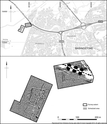
(4) Manydown, land off Rooksdown Lane (SU 6075 5343 and SU 6097 5355): a gradiometer survey on fields to the north-west of Basingstoke targeted a Scheduled Monument (No. 1001855) comprising a double-ditched rectangular enclosure and two smaller enclosures first identified as cropmarks in 1936 (fig. 18). Surface finds of pottery, tile and glass suggest these may relate to a Romano-British building. The survey results corroborated the aerial evidence and established the presence of additional smaller features.Footnote 323
Manydown, Basingstoke, results of geophysical survey showing double-ditched enclosure and two other enclosures. (Wessex Archaeology)

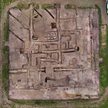
(5) Silchester (Calleva Atrebatum) (SU 64 42): excavation of the area of 3025 m2 in the north-east of Insula IX, first opened in 1997, was completed with further additions to the plans of the late Iron Age and earliest Roman phases (Periods 0–1). In Insula III (fig. 19): the area investigated in 2013Footnote 324 was extended to the north to include the complete footprint of the remains which the excavators in 1891 had tentatively interpreted as those of a bath-house. The Victorian trenches were re-excavated and the remains found in 1891 re-examined. The sequence is as for 2013, but with further complexities. The foundations of the substantial masonry structure fronted by a colonnade constructed on tile foundations on its eastern frontage, with traces of a second along the southern frontage, were observed to extend beyond the excavated area to north and west, i.e. with a ground plan of more than 900 m2. In addition there were traces of two other pre- or early Flavian phases: remains of an earlier opus signinum floor and one or two phases of construction or robber trenches apparently unconnected with the laid foundations. Three small sondages excavated through the associated make-ups produced pottery indicating a pre- or early Flavian date for this structure. Later occupation re-exposed by the excavation included the large hypocaust structure, constructed on the first-century make-up layers, which appeared to have been unused, and more of the north–south-aligned drain, partly re-exposed in 2013, which cut through the first-century foundations. Neither of these could be more closely dated than to the second century or later. A rubbish pit and the fills of street-side drainage ditches cut into the first-century foundations contained pottery of late second-century date.Footnote 325
Silchester, aerial view of south-east corner of Insula III (north at top), showing pre- or early Flavian foundations and robber (or construction) trenches. (Photo: Mike Fulford)

(6) Thruxton: 8 silver miliarenses and 45 silver siliquae, to c. a.d. 402.Footnote 326
(7) West Tytherley, West Dean Roman Villa (SU 258 271): a ground-penetrating radar (GPR) survey was carried out over Roman buildings in the grounds of West Dean House to establish the precise location of, and gauge the depth to, the surviving remains. The survey covered an area of 1.15 ha and successfully identified building remains that correspond well with plans from nineteenth-century antiquarian excavations. Roman remains at West Dean were first reported in 1741 following recovery of a mosaic pavement and subsequently through excavations in the nineteenth century prompted by discovery of a substantial building during construction of the London and South Western Railway line.Footnote 327 The antiquarian excavations revealed the site of a Roman villa consisting of two buildings, one aisled and one of courtyard type; part of a third building was also uncovered. The GPR survey successfully detected a series of anomalies associated with the known buildings, particularly the ‘Villa Urbana’. The remains appear to survive well although, if the fidelity of the Victorian excavation plan is to be believed, they extend beyond the currently designated area.Footnote 328
(8) Winchester (Venta Belgarum), 2–4 St Cross Road (SU 4785 2922): an excavation within the former Garrison Mews investigated a section of the city defences immediately west of the site of the south gate.Footnote 329 The Roman defences comprised two phases of earthen rampart and the later masonry wall, thought to have been added in the third century. The Roman fabric of the wall comprised mortar-bonded flint and a tile string course. The sequence of two ramparts and the wall was identical to that recorded during the excavation of the south gate in 1971,Footnote 330 however no late Roman bastion was identified to pair with that found in Biddle's excavation.
WEST SUSSEX
(1) Slindon, Bignor Hill (SU 9613 1196–SU 9719 1289): installation of a water-pipe within the Slindon Estate was monitored. The pipe trench crossed the Scheduled Monument of Stane Street (No. 1016621), the Roman road linking Eartham and Bignor. Two intercutting roadside ditches were recorded along the southern edge of the Roman road north of Gumber Farm and a partially surviving agger was also seen. No evidence for the road was found to the east, highlighting the comparatively poor preservation of archaeological remains outside the scheduled area.Footnote 331
EAST SUSSEX
(1) Chalvington with Ripe: a hoard of 336 radiates, mostly irregular, to a.d. 274, within a fragmented coarse ware jar.Footnote 332
SURREY
(1) Charlwood: 2 silver denarii are addenda to earlier finds of 2 Iron Age coins, 18 denarii, a quinarius and six objects with an end date of c. a.d. 161.Footnote 333
(2) Ewell: (a) Roman roadside settlement (centred at TQ 2219 6293): a second season of excavation was undertaken (in 2013) on a 10 m-wide strip of meadow, in advance of incorporation into the adjacent cemetery.Footnote 334 Beneath a previously excavated pit were two Roman wells. The earlier square wood-lined well, which had a barrel incorporated into one corner, was truncated by a later square well offset at an angle of 10–15 degrees. A number of rubbish pits, both Roman and post-mid-nineteenth century, were found in the vicinity. A further pit excavated the previous season, and found to be lined with part of an amphora, revealed a well-constructed flint and chalk lining, beneath which there was evidence for burning. Where it was anticipated that Stane Street would traverse the trench there was a 12 m-wide corridor devoid of Roman features, bordered on the western side by a ditch and gully; this may represent the ploughing out of the road over time. A possible parallel roadside gully and a fourth-century pit to the east were also identified. A large quantity of Roman pottery was recovered together with more than 200 coins and items of personal adornment.
(b) Nescot, Animal Husbandry Land, Reigate Road (TQ 224 619): the majority of 51 evaluation trenches were devoid of archaeology, but evidence of activity of several periods was found, mostly at the north end of the site. Much of this activity was prehistoric, but to the east, a group of other quarry pits or shafts was found, and one more on the south edge of the site. A hand-excavated slot was dug into one of the group and showed that it was at least 10 m across and 2.2 m deep, with a very irregular profile. The fills contained Roman finds, including the burial of several neonatal infants, and two largely complete pots, which date the infilling between a.d. 100 and 250. The animal bones were mostly of dog, pig and horse, unlike domestic sites, where most bones are of cattle and sheep, and support the view that this was not simply used as a rubbish dump, but was filled with carefully selected material. The other quarry pits were tested by machine, and only one was bottomed. Roman shafts are particularly characteristic of Ewell, having been found just over the A24 in the nineteenth century, at Hatch Furlong to the north-west between 2006 and 2009, and in the playing fields of Nescot to the south-east in the 1940s, but quarries containing such deposits are more unusual.
In the late Roman period a ditch was dug across the very north edge of the site, and this contained domestic rubbish. It was aligned north-west to south-east, and probably followed the line of a late Roman road on the same alignment, found next to the Cheam Road at Hatch Furlong just to the north.Footnote 335
KENT
(1) Ash-next-Sandwich, Richborough Castle (TR 2347 0017): limited excavation,Footnote 336 prior to construction of a new toilet block outside the defences of the fort, but within the civil settlement of Rutupiae, identified stratified deposits including a possible walking surface, but no significant structural remains. Finds included seven coins, a quantity of pottery, brick and tile, two pieces of marble veneer derived from the late first-century triumphal arch, an iron knife and a possible piece of scale armour.
(2) Canterbury (Durovernum Cantiacorum): (a) 1–2 Marlowe Arcade (TR 1491 5763): excavation prior to installation of a lift shaft and escalatorFootnote 337 uncovered the northern edge of a late Iron Age ditch, part of a triple-ditched enclosure recorded on the site in 1978 and 1980.Footnote 338 The ditch was infilled and an agricultural ‘grey loam’ had developed over the area by c. a.d. 80. During the first century a number of refuse pits were dug and there then followed a period of occupation with potential evidence for a hitherto unknown building respecting the alignment of the second-century street. This occupation phase was sealed by dumped deposits, possibly levelling in preparation for a metalled courtyard equating with that located immediately to the north-west of an early second-century building (R11).Footnote 339 Occupation and dumped deposits overlying the courtyard date to the late second to third century and overlying these were the remains of an oven, flue and burnt clay floor — again a structure respecting the second-century street.Footnote 340 These features were sealed by a demolition spread containing wall-plaster, mortar and ceramic building material likely to date to the mid- to late Roman period. A number of late refuse pits were excavated containing material dated up to the late fourth century; some had been sampled in the earlier excavations, others truncated by the 1980s shopping arcade.
(b) Rhodaus Town (TR 1502 5725): continuing excavationFootnote 341 prior to construction of student accommodationFootnote 342 uncovered a small cemetery within a square ditched enclosure measuring (internally) 17 m by 17.5 m with an entrance in its north-east corner. Twenty graves were identified and excavated and have been dated to the mid/late third century to the late fourth/early fifth century. The graves contained a range of furnishings, including 19 complete pottery vessels, some of which are potentially unique. Other finds included glass beads, glass vessels and hobnailed footwear. Two graves, one male, one female, located close to the entrance were particularly deep (over 2 m) and might represent founder burials. Each was accompanied by a timber box or casket. In the female grave this was placed over the thighs and contained a coin, a brooch, a pebble and a boar's tusk. A glass vessel had been placed behind her head. The casket in the male's grave was placed above the head. Two further enclosures, possibly established as early as the first or second century, continued in use adjacent to and east of the cemetery and a large linear feature, potentially a hollow way, traversed the site from east to west throughout all periods of Roman activity.
(c) St Peter's Lane (TR 1478 5810): limited excavationFootnote 343 on a redevelopment site encountered levelling deposits, clay floors and a plaster floor abutting a mortared flint wall. This was on the same alignment, and may have been part of the same property, as a hypocausted town-house previously identified under the neighbouring Marlowe Theatre.Footnote 344 On both sites, a similarly aligned later Roman phase with clay floors and wide beam slots was also identified. Excavation and auger data at both sites indicated that the builders took advantage of a rise in natural gravels on the north-western bank of the Great Stour's south-eastern branch, forming a low island in the generally marshy floodplain. The contemporary water table presumably lay just below the lower hypocaust floor (at 6.4 m OD), whilst the earliest other floors and yard surfaces were built up to at least 6.9 m OD.
(d) Westgate Gardens (TR 1436 5785, centred): excavationFootnote 345 outside and to the north of the site of London Gate uncovered an early roadside ditch and the latest surface of the metalled road at a depth of c. 0.8 m beneath present ground level. Continued use beyond the fourth century was indicated by what appear to be hollow ways worn into the surface by wheeled traffic. These seem to encroach on the road from either side, probably at the point of a ford or causeway across the Stour.
(e) 65 London Road (TR 1397 5814): excavationFootnote 346 revealed a 15 m-long section of north-east–south-west-aligned road formed in a shallow hollow cut into brickearth and capped by a single layer of graded road gravel. Pottery recovered from within the gravels all dated to the last quarter of the first century, suggesting an early and short-lived street. No side-drain was observed. A ditch, located 3 m to the south and set parallel to the street, was of contemporary date and probably a field boundary. Two pits and a post-hole were located south of this ditch. (f) New Dover Road (TR 1638 5586): two ditches, recorded during excavation in advance of the extension of a park and ride car park,Footnote 347 were interpreted as field boundaries in an agricultural landscape south-east of the Roman town. Running north-east to south-west, the ditches were aligned perpendicular to the line of the Roman road to Dover some 200 m to the north-east. Pottery recovered from the ditches dated to the late first or early second century.
(3) East Farleigh, Oaklands, Lower Road, (TQ 7280 5359): excavations concentrated on the Roman and Iron Age ditches which underlay the third-century buildings on the site. A Roman ditch which was dug into brickearth in the first century was 2.5 m below the Roman land surface which was covered with 600 mm of hillwash. An Iron Age ditch was parallel to the Roman ditch and dug 1.5 m into the underlying ragstone bedrock.Footnote 348
(4) Peter's Village and Medway Crossing (TQ 722 622): excavation was carried out in advance of the development of a new village, roads and bridge. Most of the areas examined were on the east side of the river Medway between the villages of Burham and Wouldham. An extensive late Iron Age and Roman landscape was revealed. By the village of Wouldham, there was a proliferation of field boundary ditches in the first century b.c. with the density of features, including pits and post-holes, suggesting that a settlement may have existed just off the site. This agricultural landscape appeared to extend across the flat ground just above the floodplain of the river Medway and the hills to the east. Close to St Mary's church, which stands on the site of medieval Burham, where the underlying geology was gravel, a section of double-ditched enclosure was identified. This substantial feature could be part of a much larger enclosure but is only dated by a single coin of a.d. 43–65. To the east, the remains of an early Roman farmstead were found in the same location as the earlier settlement, including a boundary ditch, palisade and a metalled trackway. A second Roman track was traced parallel to the river in two separate areas of excavation. However it seems that this late Iron Age–early Roman activity ceased about the end of the first century a.d. The only evidence for later Roman activity comprised post-a.d. 240 pottery and building material close to the suggested site of possibly more than one Roman masonry building, south of the site of Wouldham Hall.Footnote 349
(5) Sittingbourne, Hempstead Farm, Hempstead Lane, Tonge (TQ 9354 6314): evaluation prior to construction of new farm buildingsFootnote 350 uncovered an east–west-aligned ditch, running parallel with the line of Watling Street (A2). Two worn sherds of late Iron Age pottery and a possible potin coin recovered from within suggest that the ditch may form part of a late Iron Age or Romano-British field-system.