Nomenclature
 $\boldsymbol\alpha$:
The kernel parameter for α quadratic entropy definition
- $\boldsymbol\sigma$:
Conditional parameter defined for bird track information filtering
- C:
Bird activity degree
- d:
The parameter defining a specific date for database construction
- h:
The hour interval defined for hour track count computation
- En:
The alpha quadratic entropy
- P:
The probability of bird existence at specific hour and date
- N:
Track numbers corresponding to the specific date and conditional parameter
- N:
The track count database integrating all track count information
- G:
The grade database constructed from database N
- I:
Bird activity intensity database constructed through normalisation from database N
- Te:
Entropy threshold value defined for weighing factor computation
- w:
The weighing factor defined for integrating intensity and uncertainty information of bird
activities
- CAST:
China academy of Civil Aviation Science and Technology
- UAV:
Unmanned Aerial Vehicle


1.0 Introduction
Bird strike accidents are problematic and threatening to civil and military aviation safety. Minor bird strikes cause damages on aircraft components like engines or wind shields with high economical lost. Severe bird strikes would cause the engine shutting down or even crash [Reference DeFusco, Hovan, Harper and Heppard1–Reference Eleanor, Jacquelyn and Travis4]. Technical and management solutions are proposed to solve bird strike problems especially in airport airspaces. One important area is the timely bird detection before accidents. Optical sensors are good choices as they could capture and identify birds, but their limitations on detection range, scanning efficiency, locating accuracy and environment dependence make them only applicable for short range surveillance. Radar is considered a better choice for wide-area bird detection. Researchers have been working on bird surveillance using radar systems in both platform and technology developments [Reference Weishi5–Reference Vaughn9]. Many representative avian radar systems were developed and tested by worldwide research institutes (DeTect, Accipter, Robin, CAST (China Academy of Civil Aviation Science and Technology)) [10–Reference Huansheng, Weishi and Wenming13]. Experiments prove that avian radar systems could detect and track birds with acceptable accuracy. Some systems could distinguish birds and UAVs through micro-doppler signatures or track dynamic characters [Reference Rahman and Robertson14–Reference Muhammad, Menouar and Eldeeb17]. Derivation research achievements like bird strike risk evaluation models provide more intuitive references for air traffic managers with respect to bird strike accident avoidance [Reference Huansheng and Weishi18–Reference John21]. These functionalities could be categorised as short-term as they are dependent on real-time bird detection feedbacks from avian radar systems. However, their practical application significance is currently still controversial.
Avian radar systems are preferred to be deployed and tested in airports, which are the areas with most bird strike accidents. As aircrafts in low-altitude airspace are mostly in status of taking-off or landing, it is challenging for large aircrafts to make large manoeuverings for bird avoidance. Moreover, existing radar systems cannot guarantee a 100% accuracy of detection and identification. If detection results and strike-risk information are adopted strictly, this might result in chaos in air traffic managements and secondary risks for aviation safety. This limits the significance of existing functionalities as well as the marketing of avian radar systems.
Therefore, there is a necessity to further promote and enrich the functionality of avian radar systems. The radar’s long-range detection capability and all-weather working mode make it possible to record large amounts of data, especially for systems that have been tested for a few years. Bird surveillance information is recorded in the form of radar datasets with a target track as the fundamental recording unit [Reference Sidney, Ann-Marie and Dave22–Reference Hans, Karen and Nadine24]. If bird activities could be extracted and interpreted from historical radar observation datasets, this long-term functionality could be a good complement to the existing short-term ones with more abundant reference information. The integration of short-term and long-term functionalities could also be associated with environmental factors to make contributions in ecological remote sensing, which is favourable to enhance application significance of avian radar systems [Reference Weishi and Yifeng25–Reference Gerringer, Lima and DeVault27].
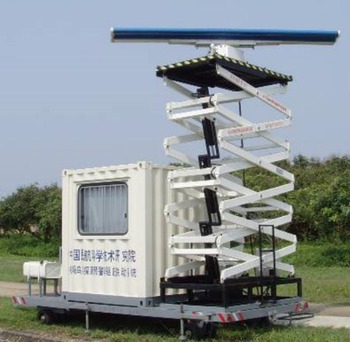
Avian radar systems developed by CAST.

Bird activities could be interpreted in spatial and temporal domains. Numerical descriptors are essential for quantitative description of their activities. The number of bird tracks is the most intuitive quantitative descriptor, but it has many limitations in practical applications:
1. There usually exists the blind zone of radar systems in many bird surveillance scenarios. The track count could not fully represent the real number of birds in coverage spaces. As existing radar systems could hardly distinguish a single or a flock of birds, the track count is also inconsistent with real bird number. Therefore, track count might fluctuate and provide misleading information in activity interpretation.
-
2. Bird activities are dependent on environments, and corresponding track counts are highly variable in temporal domain. This makes track count suitable for short-term descriptions, but its absolute number property constrains its compatibility of information integration.
-
3. The bird track count is positively correlated with radar coverage space. As radar scanning and coverage strategies need to be frequently adjusted in many scenarios, the track count might provide misleading information, which limits its application significance for long-term functionality mining.
-
4. The bird-track count does not have a positive correlation character with bird-strike risk. In many cases if dominant flight routes are predicted to have little overlapping with aircraft routes, a large track count indicates a lower strike risk. In contrast, if bird activities present larger uncertainties, the bird strike is high due to unpredictable property. Therefore, ambiguous correlation between track count and risk makes it not suitable for bird activity interpretation.
Track count limitations motivate the development of new bird activity descriptors for temporal character interpretation. This paper introduces a novel bird activity modelling and quantification method. The new descriptor is an integration of activity intensity and uncertainty information through a customised weighing algorithm based on the entropy essence. Mining results from historical radar observation datasets indicate that the proposed method could provide effective quantitative interpretation of bird activities at hour and minute scales. Daily roosting activities of local birds are clearly presented quantitatively, and its association pattern with sunrise and sunset time is plausible. Evening activities of bat swarms are also discovered by activity degree distribution, which is ambiguous using conventional quantification approach. The migration activities in night hours are also presented with reasonable temporal characters. Summarised temporal characters present good consistency and reasonability with other information sources. The other prominent benefit of the proposed descriptor is its flexibility of information integration from multiple time spans and environmental conditions, which also makes bird activity interpretation possible at arbitrarily temporal scales.
This paper is organised as follows. Section 2 introduces the radar system and airport overviews. Limitations of existing bird situation interpretation methods are discussed in Section 3. Section 4 presents the data mining method including datasets construction, feature modelling and interpretation at hour and minute scales. Experiment results are demonstrated and discussed in Section 5. Section 6 draws the conclusion.
2.0 Radar system and experiment setup
Radar datasets adopted in this paper are from the avian radar system developed by the airport technology research institute in CAST. The system is demonstrated in Fig. 1. The system is composed of a climate-controlled cabin with computer systems, data processors, wireless data transmitters and two towers mounting the dual-scanning array antennas with both vertical and horizontal scanning modes. The radar works at S band. The horizontal scanning antenna is mounted on a tower with adjustable heights. Solid state amplifiers are taken for both scanning devices with peak power of 0.4KW. The rotational speed is 25 revolutions per minute. Bird detection and tracking algorithms are developed to provide real-time functions [Reference Weishi28].
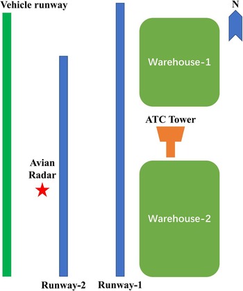
The radar system was deployed within an airport in northeast China. Due to special property of the airport and administration regulations, airport details like geographical information are not allowed to be published. Figure 2 illustrates a sketch of the airport to provide an airport overview. The airport has two runways for aircraft landing and taking off. Lengths of two runways are 3,600 and 2,900m. The red star indicates the location of radar deployment. The air traffic control tower is in the east end of two runways, and there are some warehouses around the tower.
Sketch of the airport for field experiment.

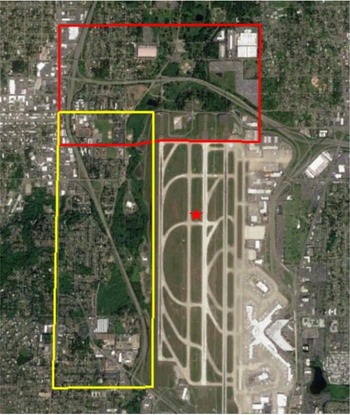
To enhance the demonstration effect, a compromised solution is proposed by selecting the map of a public airport with high similarity. Figure 3 demonstrates the map of the Seattle Tacoma International Airport (SeaTac airport) selected from the Google Earth software. Compared with Fig. 2, the selected airport has one less runway compared with the SeaTac airport, but runway directions and lengths are highly similar. Air traffic towers of the two airport are both on the east ends of runways. Warehouse locations in the adopted airport are highly similar with terminal locations of the SeaTac airport. Moreover, since the adopted airport is in northeast China, its latitude is also close to the SeaTac airport. Therefore, choosing the SeaTac airport as an alternative for presentation is a reasonable and implementable solution.
Electronic fence demonstration using SeaTac airport map.

North and west regions of the airport are selected for analysis and radar observation datasets are constructed by defining a longitude-latitude electrical fence as in Fig. 3. The red star indicates the radar setup location, its position is calculated according to its real relative position with the air traffic control tower. Historical observation indicates that local birds are mostly active in the north airport region, and the west airport region is the dominant flight path for migration birds.
3.0 Discussion on existing bird situation interpretation methods
3.1 Density heat map
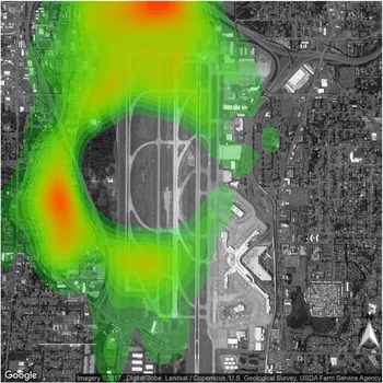
The bird track density heat map is generated within a particular region and time span [Reference Chilson, Frick and Stepanian29]. The density is calculated using the kernel density algorithm.
A bird density heat map projected on SeaTac airport map.

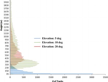
Track altitude histogram for different radar elevation angles.

Figure 4 presents an example of a density heat map that is projected over the SeaTac airport map. It is straightforward for understanding spatial distribution characters of birds. However, density heat maps are not proper for temporal character descriptions such as migration bird situations. Technically it is not very challenging to construct density heat maps for migration birds. The problem is that dynamic characters of migration birds make density heat map variations difficult for intuitive information extraction and interpretation. Since migration routes usually cover a wide area, migration birds might distribute with prominent difference among time spans in an unpredictable manner. This makes density heat maps reflect perturbations on high density area distribution within a time span. This perturbation is presented as a random flashing in the heat map animation from consecutive time spans. This flashing provides little information for migration character interpretation, and the lack of quantitative description also confines the density heat map to the static analysis. The work presented in Ref. [Reference Kranstauber, Bouten, Leijnse, Wijers, Verlinden, Shamoun-Baranes and Dokter30] introduces a novel concept of vertically integrated reflectivity (VIR) to demonstrate the migration bird situation within the effective surveillance range of weather radar systems. One motivation of developing VIR is complementing the insufficiency of existing density heat maps in bird situation presentation and quantification. Moreover, the heat map generation principle makes it difficult for information integration with other spatial-temporal configurations.
3.2 Altitude histogram
Histogram is a representative statistical tool for data modelling and fitting [Reference Balzanella, Rivoli and Verde31–Reference Rauch and Šimůnek33]. Bird track altitude could be presented in histogram forms either. Compared with the density heat map, the altitude histogram completes bird spatial character interpretation in the altitude dimension. Figure 5 demonstrates an example of altitude histogram under different elevation angles. The dataset comes from a field experiment using the system as demonstrated in Fig. 1, which is deployed at another airport. This histogram is used to evaluate track quantities at different altitude spans and choose a proper elevation angle for monitoring the area with large bird densities. More birds at larger altitude spans are observed with increasing elevation angles, which is consistent with radar scanning characters. Like density heat maps, altitude histograms are confined to a single spatial domain. Its temporal variation characters are difficult to be interpreted effectively.
3.3 Direction histogram
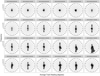
Flight direction could be deduced from spatial-temporal information in track plots. Statistical characters of flight direction are valuable for bird activity analysis and identification. Figure 6 presents a representative flight direction histogram in polar form. Bird quantity and flight direction variations at different hour spans are prominent and intuitive. However, this histogram is not suitable for information integration with multiple conditional parameters. Moreover, for local birds that might fly more arbitrarily, polar histograms of flight directions might be misleading and not intuitive for activity interpretation.
Polar histogram of bird track directions.

Existing bird situation interpretation methods have their respective advantages and limitations. They generally provide static visualisation results with intuition but are not suitable for information integration under multiple conditional parameters. A new bird activity modelling and interpretation method for flexible temporal domain description is required.
4.0 Bird activity characters mining in temporal domain
Temporal activities could be characterised at multiple scales such as day, hour or minute scales. This paper focuses on the temporal character mining at hour and minute scales. Characters mining at other scales are future works.
4.1 Data filtering
The database construction is fundamental for bird activity mining. In this paper the database is constructed through radar data filtering at day scale. Radar observation data of one specific day is characterised by an hourly track count vector whose dimension is 24-by-1. The track count distribution is not only dependent on bird activities but also environments especially weather conditions. Historical works have demonstrated close relevance between bird activities and weather conditions [Reference Coates, Casazza, Halstead, Fleskes and Laughlin34, Reference Mary35]. Therefore, it is more reasonable to extract and interpret bird activity characters based on similar weather conditions.
This paper defines a conditional parameter  $\boldsymbol\sigma$ which includes various weather information for data filtering. The filtered database is denoted as
 ${\bf{N}} = \left\{ {N\!\left( {{d_1}\!\left| {\boldsymbol{\sigma }}\! \right.} \right),N\!\left( {{d_2}\left| {\boldsymbol{\sigma }}\! \right.} \right), \ldots ,N\!\left( {{d_K}\!\left| {\boldsymbol{\sigma }}\! \right.} \right)} \right\}$. The symbol
 $N\!\left( {{d_k}\!\left| {\boldsymbol{\sigma }}\! \right.} \right)$ represents a track count at the date d k with parameter
 $\boldsymbol\sigma$.
Mapping relationship between normalised intensity and grade

4.2 Bird activity mining at hour scale
A novel concept of activity degree is introduced as a descriptor for quantitative bird activity interpretation. It is assumed that bird activity is characterised from intensity and uncertainty aspects. The activity degree computation is composed of intensity extraction, uncertainty extraction and their integration, which is decomposed of four steps.
STEP 1: Normalised intensity calculation. The normalised intensity is calculated from track count information at hour scale. For date d k, its normalised intensity is denoted as  ${\bf{I}} = \left\{ {I\!\left( {1\!\left| {{d_k}}\! \right.} \right),I\!\left( {2\!\left| {{d_k}\!} \right.} \right), \ldots ,I\!\left( {24\!\left| {{d_k}}\! \right.} \right)} \right\}$ with
 $I\!\left( {i\!\left| {{d_k}}\! \right.} \right)$ representing the hour interval between hour i-1 and i. The normalisation range is between 20 and 100. The lower bound is 20 instead of 0 as it is unreasonable to define minimum track count as no bird activity. It should be noted that this time span for normalisation is not confined to one hour but adjustable for specific problems.
STEP 2: Intensity grading. Normalised intensities from all selected dates compose a database N. A normalised intensity array is formulated as I(h k, d) for hour h k. The symbol d indicates all dates within N. Intensity fluctuations from slight track count variations might be misleading in activity interpretation. To solve this problem, a smoothing procedure is proposed by categorising intensity into 10 grades. The mapping relationship between grade and intensity is presented in Table 1. The new database after the mapping is denoted as G(h, d) with consistent definition of h and d as in I(h k, d).
STEP 3: Uncertainty quantification. Large grade variations indicate higher uncertainty and corresponding bird activities are difficult to be predicted. This mechanism is realised through the entropy concept. Since the grade mapping refrains the impact from intensity fluctuations, a more sensitive entropy evaluation method is required. This paper selects the α-quadratic entropy [Reference Fauvel, Chanussot and Benediktsson36] to quantify activity uncertainty:
 \begin{align}E{n^\alpha }\!\left( {{\bf{G}}\!\left( {h,{\bf{d}}} \right)} \right) = \frac{1}{{{2^{ - 2\alpha }}}}\sum\limits_{j = 1}^{10} {{{\!\left( {{P^j}\!\left( {{\bf{G}}\!\left( {h,{\bf{d}}} \right)} \right)} \right)}^\alpha } \cdot {{\left( {1 - {P^j}\!\left( {{\bf{G}}\!\left( {h,{\bf{d}}} \right)} \right)} \right)}^\alpha }} \end{align}
The term  ${P^j}\!\left( {{\bf{G}}\left( {h,{\bf{d}}} \right)} \right)$ indicates the probability of G(h, d) at grade j. The larger uncertainty enlargement parameter α indicates a higher uncertainty sensitivity of entropy. This paper selects α as 0.7. It is larger than recommended value of 0.5 as the grade definition limits intensity fluctuation, and the α value needs proper enlargement to maintain its entropy sensitivity [Reference Pal and Bezdek37, Reference Dai38].
The flexible definition of α makes it applicable for various scenarios. For complicated bird activities with large track count fluctuations, it does not indicate a definite higher activity uncertainty, and the α value should be small to constrain uncertainty enlargement. If bird activities have limited interference, the count fluctuation is small and a larger α value is required to enlarge the uncertainty interpretation capability. This is the dominant reason for selecting α-quadratic entropy instead of the conventional entropy.
STEP 4: Weighing factor and activity degree calculation. Intensity and uncertainty information should be integrated to interpret bird activity characters. The straightforward integration of their numerical value is improper due to their independent physical meaning and dimensions. This paper develops a weighing strategy for uncertainty characters and applies it on intensity descriptor for information integration. An uncertainty weighing factor based on α-quadratic entropy is defined as [Reference Jia, Ning, YongJun and BaoFa39]:
 \begin{align}w\!\left( {E{n^\alpha }\!\left( {h,{\bf{d}}} \right)} \right) = 1 + \left( {{2^{ - 2\alpha }}} \right) \cdot \exp \!\left( {E{n^\alpha }\!\left( {h,{\bf{d}}} \right) - {T_e}} \right)\end{align}
The weighing factor is larger than one, indicating its extra enlargement of intensity. The parameter T e is the entropy threshold. Equation (2) indicates when the entropy is smaller than T e, birds present a smooth track count variation pattern, the weighing factor provides a limited intensity enlargement. When the entropy is larger than T e, the weighing factor presents a nonlinear increment to enlarge uncertainty contributions.
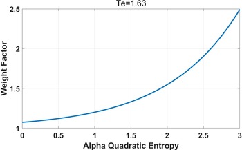
Relationship between entropy value and weight factors.

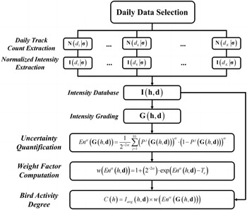
Flowchart of bird activity degree extraction at hour scale.

The current threshold selection takes a half-manual strategy. Bird activities are categorised into large and small variation groups according to track count information, and two groups of entropy information are presented in histograms. The threshold is a value which minimise the overlapping probability between large and small variations. The threshold extracted from our database is 1.63. The relationship between weighing factor and entropy in Fig. 7 indicates an exponential increment of weighing factor when the entropy is larger than the threshold.
Flowchart of bird activity degree extraction at minute scale.

Daily track count distribution and selection within the north airport region in 2018.

Bird activity pattern within the north airport at hour scale-August.

Bird activity pattern within the north airport at hour scale-September.

Bird activity pattern within the north airport at hour scale-October.

The activity degree at hour h is calculated by integrating intensity and weighing factor:
 \begin{align}C\!\left( h \right) = {I_{avg}}\!\left( {h,{\bf{d}}} \right) \times w\!\left( {E{n^\alpha }\!\left( {{\bf{G}}\!\left( {h,{\bf{d}}} \right)} \right)} \right)\end{align}
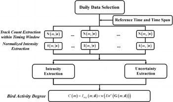
The term  ${I_{avg}}\!\left( {h,{\bf{d}}} \right)$ indicates an average value of I. The bird activity degree is not confined within 100 but this does not influence its interpretation capability for bird activities. Figure 8 presents a flow chart of activity degree extraction at hour scale.
4.3 Bird activity mining at minute scale
Compared with the hour scale analysis, the mining procedure at minute scale is similar except for the selection of temporal sampling interval, which is critical in minute scale analysis. If the sampling interval is set to one minute, the track count information might not be sufficient to support statistical analysis. It is also unreasonable to interpret bird activity characters in every single minute. Track count fluctuations from small sampling intervals also influence intensity and uncertainty information quality. This paper sets the sampling interval to 10 minutes as a fundamental temporal unit. A time span distributed around a reference time is defined for intensity and uncertainty extraction.
The flow chart for minute scale analysis is presented in Fig. 9. Compared with Fig. 8, some mathematical formulas are replaced by text description. The major differences are reference time and time span definitions.
5.0 Results and discussion
5.1 Database construction
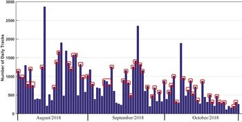
Radar observation data in August, September and October from 2017 to 2019 is selected for database construction. Figure 10 presents an example of daily track count distribution which is arbitrarily selected from data in 2018. Track count fluctuations are contributed by both bird activity characters and environmental interferences. Dynamic clutter signals from moving precipitations are dominant source of false bird tracks. These false tracks are obviously not applicable for activity character mining and excluded through conditional parameter filtering.
Bird activity pattern within the west airport at hour scale-August.

Bird activity pattern within the west airport at hour scale-September.

Bird activity pattern within the west airport at hour scale-October.

In this experiment, the conditional parameter  $\boldsymbol\sigma$ is composed of a series of weather parameters within the normal range. Normal days are selected from the original radar observation datasets by excluding days with strong gusts, precipitation, fog and radar hardware problems. Weather records corresponding to normal days are collected to build a weather parameter dataset. Each weather parameter is denoted by a sub-dataset. For a weather parameter like the temperature, its lower and upper bounds are 20% and 80% percentile values extracted from the corresponding sub-dataset. In this paper, the temperature (unit: degree), air pressure (unit: hPa), humidity (unit: %) and wind speed (unit: m/s) are adopted to compose the conditional parameter
 $\boldsymbol\sigma$. Their numerical ranges are [15, 28], [980, 1,030], [67, 81] and [3.2, 9.1], respectively. According to these conditional parameters, selected dates are marked with red rectangles in Fig. 10. The same filtering procedure is applied on other datasets collected from 2017 to 2019, including datasets for the west airport region.
5.2 Hour scale analysis
North and west airport regions are consisted of different bird types, feature extractions at hour scale are proceeded in north and west airport regions, respectively.
5.2.1 North Airport Region
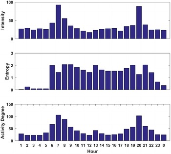
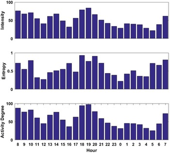
Intensity, entropy and activity degrees in the north airport region are presented from Figs. 11, 12 and 13. There is a prominent consistency between activity intensity and degree. One distinctive character is that birds are more active in morning and evening hours. This is consistent with local bird habitats according to local observers’ understanding [Reference Carmen, Katherine and Amy40].
Explorations and mining on differences between intensity and activity degree could extract more interesting and useful information. Birds behave more active in noon hours in activity degree than intensity. This is contributed by their larger activity uncertainties around noon hours. One reasonable explanation is that birds fly toward further north residence areas where an outdoor garbage yard is located as a food source. The residence area is out of the radar beam coverage so that track counts present large fluctuations. Another distinctive difference between intensity and activity degree occurs around dawn hours after sunsets. Intensities present prominent decrement after the sunset but activity degrees still reflect bird activities. This phenomenon is discussed with local observers and ornithologists. It probably indicates bat swarm activities rather than birds. Bat swarms usually fly at low altitude layer among trees, which are difficult to be detected by radar. Their track counts possess high fluctuation patterns which is reflected as a larger weighing factor. Therefore, even though track counts of bat swarms are much smaller, their activities could still be reflected from activity degrees. This proves that activity degree is more proper and sensitive for bird activity interpretation.
5.2.2 West airport region
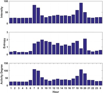
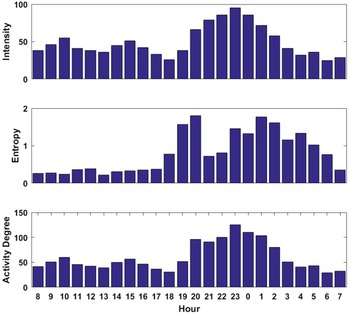
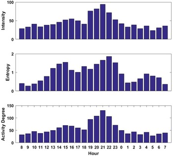
Both local and migration birds exist in the original west airport region. In the locating and environmental evaluation stage before airport construction, local birds in this region are considered as a threat to aviation safety. During the airport construction the original wood vegetation in this region was replaced with vegetation which are not suitable for bird habitation. This strategy was effective with prominent local bird activity reduction. This ecological management strategy does not work for migration birds and they are not considered as threats since their overlapping degree with flight routes is low. To demonstrate the activity variation consistency in night hours, the time axis is shifted from 08:00 to 07:59 in Figs. 14, 15 and 16.
Autumn migrations in the airport area usually start around the middle of August, and the temporal character of night migration is not prominent. It could be observed from Fig. 14 that dominant migration activities occur between 17:00 and 20:00. This time span is challenging for other types of sensors to conduct cross validations. Migration activities get distinctive in September and the dominant hour span is [22:00, 01:00], as illustrated in Fig. 15. In contrast, activity characters in the day time does not reflect clear patterns due to limited track samples.
Migration activity pattern gets more prominent in October as illustrated in Fig. 16. Compared with September, the dominant migration hour span is shift to [19:00, 22:00]. However, local bird activities presented in Fig. 16 are worthy of further discussion. According to local observers, there are occasional bird activities in specific dates of October. Visual observations about these activities are biased on the consideration of local birds but this needs more verification works.
These results demonstrate that extracted characters present plausible temporal activity patterns and good consistencies through comparison with conventional understanding. These characters are promising to be integrated with track motion characters to build a more reasonable bird strike evaluation model for arbitrarily selected time span.
5.3 Minute scale analysis
5.3.1 Temporal characters around sunrise
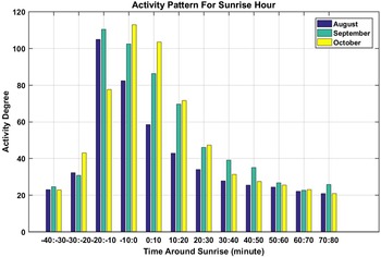
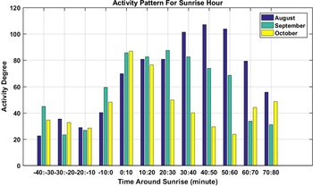
This section presents temporal activity characters at minute scale with sunrise as a reference time point. Figures 17 and 18 demonstrate activity degree distributions in north and west airport regions, respectively. The negative value indicates the time before sunrise. The minute span for sunrise analysis is [−40, 80]. In August, birds demonstrate higher activity degrees at the span of [−20, −10]. Features in September are similar with slightly higher activity degrees. In October the dominant active time span is shifted to [−10, 20] with a higher activity decrement rate. One possible explanation for this difference might be larger temperature decrement in October. These characters are discussed with local observers and ornithologists. What presented in Fig. 17 are consistent with their understandings.
Bird activity at minute scale around sunrise-North Airport Region.

Bird activity at minute scale around sunrise-West Airport Region.

Temporal characters in the west airport region around sunrise are presented in Fig. 17. Due to the ecological management, local bird activities in this region are not prominent any more. Compared with Fig. 16, activity degrees in the west region demonstrates larger monthly differences. This is not a phenomenon related to bird activities but contributed by insufficient track samples. As mentioned, dominant active birds in this area are migration birds but their behaviours do not have close relevance with sunrise or sunset, but concentrate in night hours. Therefore, track count is small within the span for minute scale analysis. Insufficient samples limit the accuracy of intensity and uncertainty extraction. Therefore, it is difficult to interpret representative local bird activities around sunrise in the west airport region.
Figures 17 and 18 indicate local bird activities could be effectively interpreted around sunrise. Moreover, the analysis method at minute scale is not confined to sunrise or sunset time. Reference time and time span selections are flexible to accommodate application requirements. For example, the reference time could be set within airport rush hours. The extracted activity character might provide useful references for intelligent bird strike risk evaluation [Reference Weishi, Jie and Jing41].
5.3.2 Temporal characters around sunset
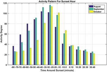
Temporal studies around sunset are similar. The sampling interval is also 10 minutes and the time span is shifted to [−80, 40]. Figures 19 and 20 demonstrate activity degrees around sunset in the north and west airport regions, respectively.
Activity pattern at minute scale around sunset hour-North Airport Region.

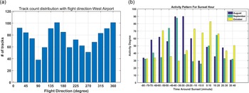
(a) Bird flight direction histogram in the west airport region around sunset. (b) Activity pattern at minute scale around sunset hour, West Airport Region.

For north airport region, birds are active around 30 minutes before the sunset with a smooth activity degree decrement in August. Distribution patterns in September and August are similar. The maximum activity degree distributes about 20 to 30min before the sunset. This time span has close relevance with birds roosting activities. Monthly differences of activity degree distribution are reasonable with season variations.
Like the case of sunrise study, activity characters in the west airport region around sunset are ambiguous and difficult for interpretation either. Besides the insufficient track count, the ambiguity in this region is also caused by randomness property of bird activities. Figure 20(a) illustrates the flight direction histogram for bird tracks in the west airport region within sunset association time span. Compared with north airport region, the track quantity in the west airport region is much less. The direction distribution reflects randomness, which is contributed by both the limited track quantity and occasionality of local bird activities in this area. These make association patterns in Fig. 20(b) present distinctive difference with the north airport region. Moreover, from another viewpoint, it might be deduced that birds in this region are not local type or they do not habitat in this region. This also provides a chance to utilise temporal characters for bird type deduction or identification.
6.0 Conclusion
Avian radar systems have unique advantages in long-range surveillance compared with other types of sensors. Existing technologies and systems demonstrate good performance for most bird targets detection and tracking. However, existing systems and methods are confined to short-term functionality mining and interpretation. Data mining over historical radar dataset is also biased on spatial domain modelling which is not suitable for bird activity description in temporal domain. These make information from avian radar systems doubtful and controversy for airport managements. A long-term temporal bird activity modelling and interpretation method are required based on historical radar observation datasets.
In this paper, a bird activity modelling and interpretation method in temporal domain is proposed to complement existing methods. A novel concept of activity degree is defined to integrate activity intensity and uncertainty information with a specific weighing strategy according to the entropy essence. The method is applicable at both hour and minute scales with slight configuration adjustment. Radar observation datasets selected from an avian radar system deployed in the airport are built to verify the proposed method. Electronic fences are defined in datasets construction for local and migration bird activity analysis, respectively. Local bird activities like daily commuting and roosting are clearly presented in temporal domain, the activity association pattern within sunrise and sunset time spans is reasonably presented. The hidden bat swarm activity in evening hours is discovered, which is ambiguous using conventional descriptors. Extracted migration activities present clear and reasonable temporal characters. Summarised temporal activity characters demonstrate plausible patterns and consistency with bird observers and ornithologists understanding. These prove that the proposed method is promising for long-term bird situation study and prediction in a more comprehensive manner. Its integration with bird strike risk evaluation model could further elevate the application significance of avian radar systems. However, the method’s performance is highly dependent on sample sufficiency and confined by specific conditional parameters. Moreover, the method currently focuses on the temporal activity modelling and interpretation within a fixed spatial domain and lacks the joint description capability in spatial-temporal domain. These would be the future extension of bird activity modelling and interpretation method.
Acknowledgements
This paper is supported by Beihang Zhuobai Program under Grants KG21000501, Guangxi Natural Science Foundation under Grant 2020GXNSFBA297119, the Guangxi Science and Technology Plan Project under Grant GuiKe-AD20238025, the National Key Research and Development Program (2016YFC0800406), and jointly funded by the National Natural Science Foundation of China (NSFC) and Civil Aviation Administration of China (CAAC) (U1933135, U1633122).