Introduction
Stilt-house settlements are found in a variety of archaeological and contemporary contexts built next to, or above, lakes, rivers and coastlines to facilitate aquatic resource exploitation or defence. Present-day stilt-house settlements, such as those of Brunei, Myanmar and Thailand, are often located in areas prone to variable tides and tropical rains, and comprise clusters of variously sized houses, connected by bridges and usually inhabited by extended family groups (Rudovsky Reference Rudovsky2003). Historical examples include the stilt-house settlements of Ganvié, on Lake Nokoué, in Benin, which were built in the sixteenth century AD for defensive purposes and, in total, accommodated up to 20 000 inhabitants (Bahamón & Álvarez Reference Bahamón and Álvarez2009); and the riverside settlements of the Warao people of the Orinoco delta in Venezuela who were encountered by Columbus, Vespucci and Alonso de Ojeda, and who continue to live in stilt houses today (Granberry Reference Granberry, Keegan, Hofman and Ramos2013).
The first-millennium AD stilt-house villages of the Maranhão—a state in the east Amazon lowlands of north-eastern Brazil—are among the least-known archaeological sites of that country (Prous Reference Prous1992). They are the subject of scant research due to their relatively poor preservation and the lack of suitable field methods for their investigation. This paper reports the results of recent non-invasive fieldwork that has collected new data from a series of stilt-house settlements in the Turiaçu River Basin, with the aim of increasing awareness of the Maranhão sites and contributing to the wider study of this settlement type around the world.
Previous archaeological research
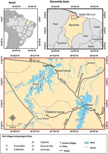
The study region, 200km south-west of the state capital, São Luís, comprises an estuarine territory of approximately 20 000km2 in the northern part of the state of Maranhão, and is situated within an area of environmental protection (APA; Decree 11 900 of 11 June 1991, reissued 5 October 1991, see Franco Reference Franco2012; Figures 1–2). The area is drained by the Pindaré, Pericumã and Turiaçu rivers (Ab’ Sáber Reference Ab'Sáber2006; Franco Reference Franco2012) and, climatically, is characterised by two seasons, with rain from January to June, and drought from July to December.
Map of the River Turiaçu and the sites discussed in the article. Map by Adolfo Okuyama.

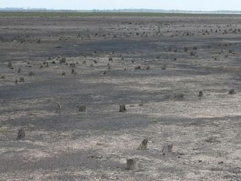
The pile dwellings of the Coqueiro stilt village of the Maranhão, taken during the dry season of 2012. The village, which is not included within the study presented here, nevertheless provides a good illustration of how the sites appear when identified in areas where they are fully exposed during times of drought. Photograph by Alexandre Navarro.

The Maranhão stilt-house settlements are scattered across a floodplain comprising river channels and lakes of varying sizes; they were constructed in locations where rivers broadened out to form lakes, using tree stumps to support elevated structures above the water before subsequently adopting the use of purposefully shaped piles (Simões Reference Simões1981; Correia Lima & Aroso Reference Correia Lima and Aroso1989; Corrêa et al. Reference Corrêa, Machado and Lopes1991; Leite Filho Reference Leite Filho, Pereira and Guapindaia2010; Navarro Reference Navarro2013, Reference Navarro, Barreto, Lima and Betancourt2016).
Ongoing archaeological investigations suggest that the various river floodplains of the Amazon were densely populated in pre-colonial times (Roosevelt Reference Roosevelt1991; Balée Reference Balée1994; Petersen et al. Reference Petersen, Neves, Bartone, Silva, Lehmann, Kern, Glaser and Woods2003; Politis Reference Politis2003; Schaan Reference Schaan2004; Heckenberger Reference Heckenberger2005; Hornborg Reference Hornborg2005; Moraes & Neves Reference Moraes and Neves2012). This corroborates the ethnohistorical reports of Carvajal on the Orellana expedition and the accounts of Acuña and Rojas from the expeditions of Aguirre and Ursúa in the sixteenth century (Porro Reference Porro1992). Stilt-house settlements in the neighbouring state of Pará were described in the mid eighteenth century thus:
Many nations live on lakes, or in the middle of them, where they build, on top of the water, their similar two-storey houses, erected from sticks and palm branches, and there they live happily like fish in the water. The reason why they build their populations and shelter in the lakes is for the great abundance in turtles, manatees, and other aquatic animals, and for being more protected from the attack of enemies (Daniel Reference Daniel2004 [1772–1776]: 280).
The earliest record of such structures in Maranhão comes from the topographical mapping of the captaincy by the engineer Pereira do Lago. When visiting the village of Viana, he wrote that it was connected to seven lakes, including the Cajari—in the “margin of this lake, in parts that the water covers in winter, appear remains and signs that there once were buildings and even street-like lines” (Pereira do Lago Reference Pereira do Lago2001 [1872]: 40). In the early twentieth century, Raimundo Lopes (Reference Lopes1916, Reference Lopes1924, Reference Lopes1970) made a series of observations regarding these stilt houses, and published sketches and maps showing the extent of Cacaria, which at 2km in length, is the largest site at Cajari Lake.
Methods
The study area focuses on the Turiaçu Basin, the largest river drainage in western Maranhão. The Turiaçu River is 720km long and flows into the Atlantic Ocean through the reentrâncias maranhenses, a complex estuarine system of islands, bays and coves largely covered by mangrove forest. The settlements are located in an area where the river widens to form numerous lakes, before narrowing again and discharging into the ocean (Figure 1).
The sites were discovered during the drier period of the year, between July and December, when water levels were lower. Local informants guided archaeologists to the sites before they were again submerged during the following wet season, between January and June.
Identification of the extent and organisation of each site was made possible by mapping the tops of the wooden piles, which were either partially submerged or fully exposed. The positions of these piles were marked with stakes, either on foot or by canoe, and then mapped using a total station. In some cases, sands deposited by the river have reduced the visibility of the piles, so it is probable that not all of them have been identified. Generally, the piles are positioned close together. In circumference, they reach up to 0.5m, but most are between 0.2 and 0.3m. The majority of the timbers are hardwood, mainly masaranduba (Manilkara huberi) and araguaney or yellow ipê (Tabebuia sp). The thickest piles are generally set vertically and their tops have been smoothed by centuries of erosion from submersion and exposure. The overall length of these piles remains unknown, although one pulled loose by erosion measured 4m. Archaeological materials on the riverbed surface within each concentration of piles were systematically collected using 1 × 1m grids. During the dry season, the riverbed surface was recorded as being between 0.3 and 0.5m deep at all the sites that remained submerged, with the exception of Encantado. Pile concentrations were plotted using GPS. The results presented here were collected over a period of four years.
Site layouts and dates
Boca do Rio
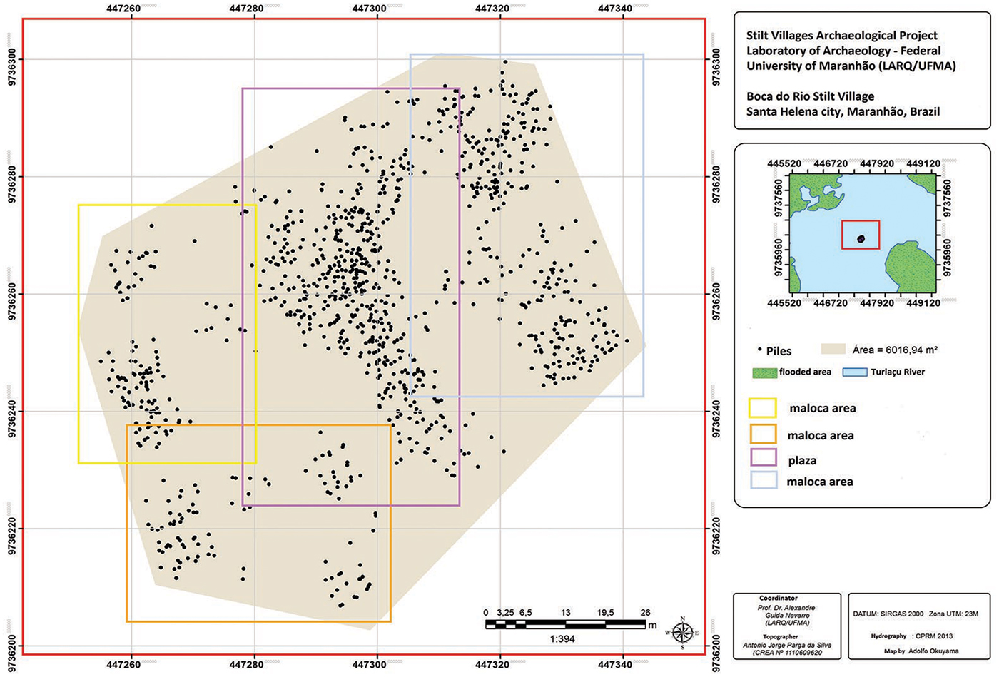
The Boca do Rio site is located in the middle of the Turiacu River channel. Fieldwork has identified 1071 in situ wooden piles across an area of approximately 0.6ha. The nucleus of the site is a linear arrangement of piles, around 65m in length (and up to 25m wide) oriented north-west to south-east. Four smaller clusters of piles, on a similar alignment, lie to the immediate north-east and south-west (Figure 3).
The mapping piles were carried out with total station and satellite georeferencing (GPS and GIS) at the Boca do Rio site. The colours refer to maloca and plaza areas. Map by Adolfo Okuyama.

Cabeludo
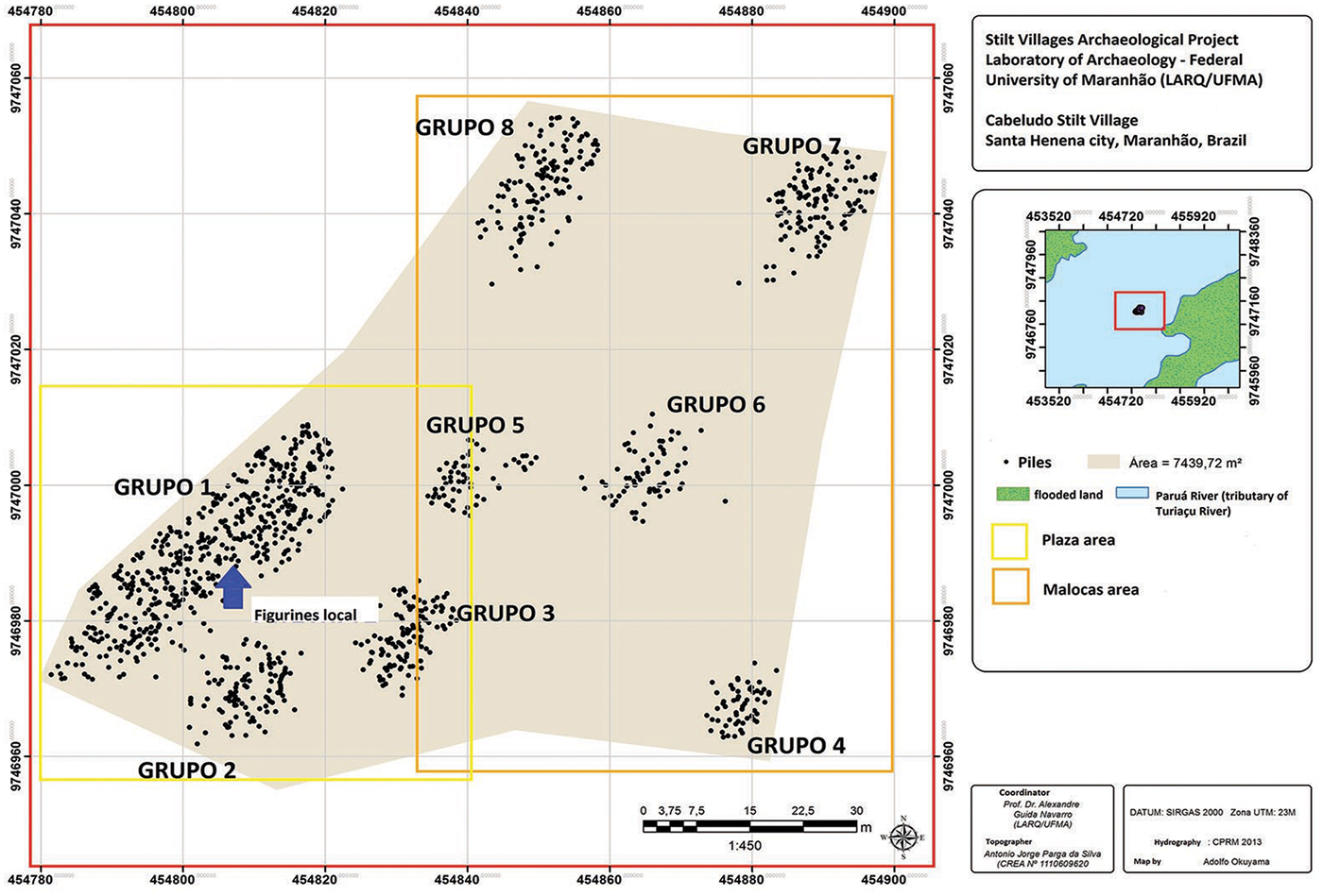
Cabeludo is the largest of the sites investigated in terms of the number of piles that we were able to document, with 1150 recorded across an area of 0.74ha in the middle of the Paruá River, a tributary of the Turiaçu. As with the Boca do Rio site, Cabeludo consists of several concentrations of piles. The largest nucleus is an area of approximately 55 × 15m, oriented north-east to south-west. Seven smaller clusters of piles, on a broadly similar alignment, lie to the east and north-east. The main concentration appears to have been connected by a bridge or causeway to the cluster located closest to it; the other clusters may also have been connected, although the accumulation of large quantities of sand means that this cannot be verified (Figure 4).
Location of the stilts recorded at the Cabeludo archaeological site, surveyed using satellite geo-referencing. Map by Adolfo Okuyama.

Armíndio
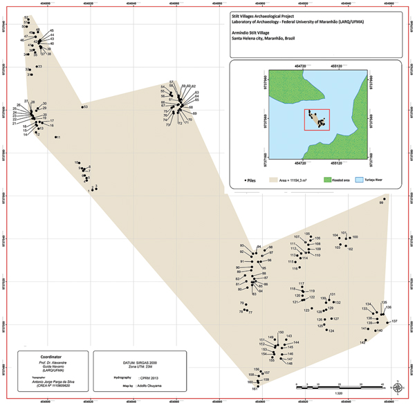
The Armíndio site comprises 145 piles, but these are spread across an area of 1.12ha. Located in the middle of the Turiaçu River channel, the piles are broadly aligned north–south, with the settlement as a whole oriented north-west to south-east. It comprises a number of pile concentrations grouped into two larger sets (Figure 5), with clusters of piles ranging between 12 and 24m, and with no evidence for a larger primary concentration or nucleus, as was shown at Cabeludo and Boca do Rio.
Location of the stilts recorded at the Armíndio site, surveyed using satellite geo-referencing. Map by Adolfo Okuyama.

Caboclo
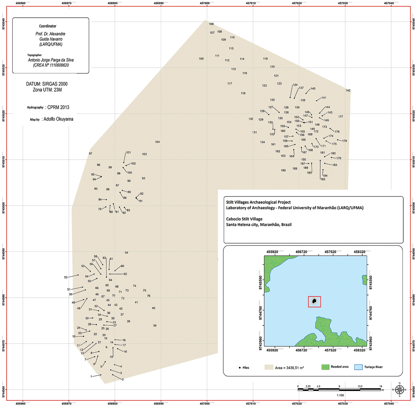
The Caboclo site is the smallest of the sites included in this survey, covering an area of 0.3ha. It comprises 161 piles grouped into three clusters located in the middle of the river channel and oriented north-east to south-west (Figure 6).
Location of the stilts recorded at the Caboclo site, surveyed using satellite geo-referencing. Map by Adolfo Okuyama.

Bathymetric measurements, taken during peak flood season (May, 2017), recorded the maximum water depth at each of the submerged sites: Cabeludo, 5.08m; Caboclo, 4.2m; and Armíndio, 5.46m; the depth at Boca do Rio could not be measured due to the strong waves during the survey season. There is currently limited evidence for if and how water levels may have differed during the first millennium AD.
Encantado
The site of Encantado is located in a different basin and has not yet been studied; it was, however, visited in the dry season and a sample (wood stilt) was collected for dating in order to determine whether it was contemporaneous with the sites of the Turiaçu Basin. Although it is part of another basin, it appears that the settlement pattern is similar and that it is indeed contemporaneous with the other sites, thereby suggesting the concept of one great overall territory.
Radiocarbon dating
Wooden piles from each site were sampled for radiocarbon dating (Table 1). The size of the piles used for construction may bias estimates of settlement age as a result of the old wood effect; using dendrochronology, Vieira et al. (Reference Vieira, Trumbore, Camargo, Selhorst, Chambers, Higuchi and Martinelli2005) have found Tabebuia trees in the Brazilian Amazon with ages varying between 104 and 182 years. The dates obtained from the largest concentration (or nucleus) of each settlement give a range of AD 770–1040 for the sites as a group, indicating that at least these central areas are all broadly of the same period. Two dates from the Cabeludo site, one from the nucleus and another from the cluster farthest from it, demonstrate that these were also contemporaneous with one another (Table 1). It was not possible, however, to submit samples from every individual pile cluster, meaning that it remains unknown whether all the structures at each site are of the same date.
Radiocarbon dating of the wooden piles of stilt villages surveyed in Maranhão, modelled using BetaCal3.21: HPD method and the SHCAL13 calibration curve (Bronk Ramsey Reference Bronk Ramsey2009; Hogg et al. Reference Hogg, Huan, Blackwell, Niu, Buck, Guilderson, Heaton, Palmer, Reimer, Reimer, Turney and Zimmerman2013).

The artefacts
The systematic collection of artefacts at regular intervals allowed for the demarcation of settlements and their mapping. Finds include complete and broken ceramic vessels (painted and unpainted), ceramic figurines, ceramic griddles (many with basketry and leaf marks) used for cooking food, spindlewhorls, lithics (with an emphasis on polished small axes), a muiraquitã (a polished nephrite pendant in the shape of a frog) and various wooden remains, including an axe-haft and what is either an oar or a borduna (mace or club). Burnt seeds from the babassu tree (Attalea speciosa) and other palms were also recovered from within some of the ceramic vessels, which themselves were dated to the pre-colonial period. A large quantity of charcoal was also found in a dense concentration within these vessels.
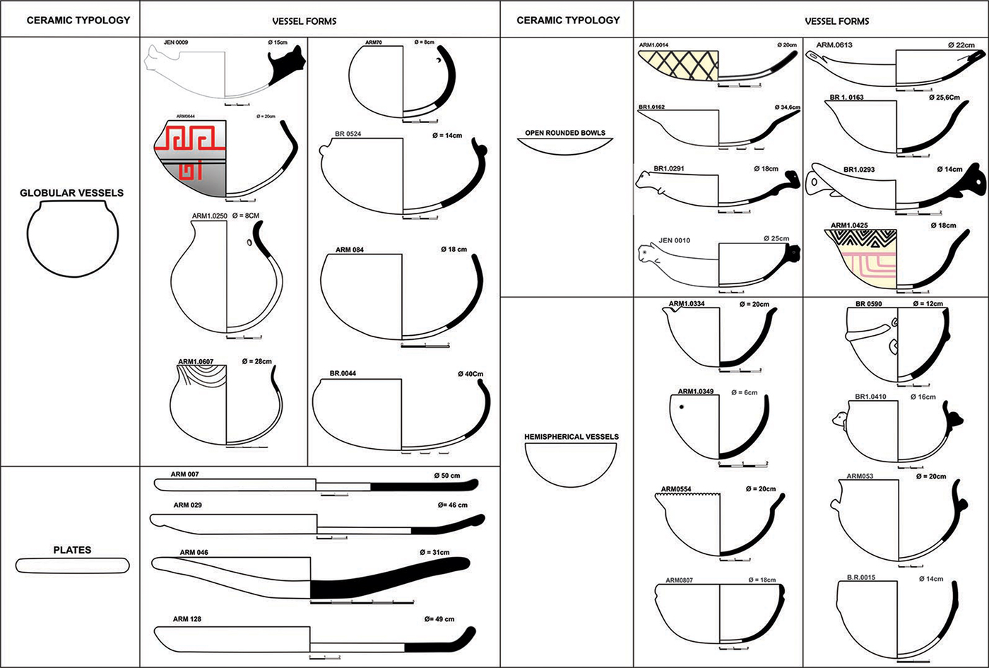
Analysis of the 2500 sherds collected from the sites has identified 74 types of vessel, indicating a complex ceramic industry (Figure 7). While the assemblage exhibits great variability, the broadly even distribution of the 74 wares across all the sites suggests a close social and economic integration between the settlements.
Ceramic typology showing different vessel types found across the stilt villages. Drawing by Flaviomiro Mendonça and Wilson Garcia.

Vessels were classified according to typological categories: plates, griddles, open rounded bowls, globular vessels, hemispherical vessels, figurines and spindles (Sheppard Reference Shepard1956; Rice Reference Rice1987). The capacity of the hemispherical vessels is less than half a litre, while the globular containers are larger, often holding more than a litre. Small ceramic vessels were probably used for the storage of liquids and food, as well as resin—an important material locally available at these sites and used as a protective coat for decorative paintings on the vessels. There are carbonised residues on the surfaces of many sherds, indicating the use of vessels for cooking (Arnold Reference Arnold1985; Rice Reference Rice1987; Gomes Reference Gomes2017).
The distribution of the ceramic material was concentrated around the densest pile clusters, becoming sparser towards the edges of the settlements. The ceramics are of a high quality, coil-built from clay tempered with cauxi (spicules of freshwater sponges) and grog, and well fired. Most of the vessels have carinated forms, with either direct (undifferentiated) or everted rims, and with either flat or rounded rim lips; they were slipped, painted and burnished before and after firing. Polychrome decoration is an important feature, with many pieces painted with black and red on a white slip, probably belonging to the wider Amazonian Polychrome Tradition (Roosevelt Reference Roosevelt1991). Many sherds, for example, are decorated with zig-zag or spiral motifs, similar to those found on vessels of the Marajoara regional style. Decorative ceramic appliqué, found at each of the sites, predominantly take the form of mammiforms, although geometrical shapes, amphibians, fish, mammals and poultry are also represented.
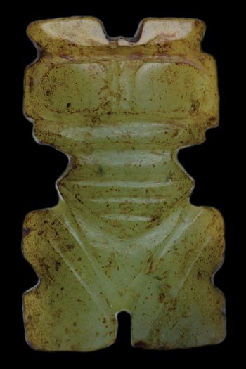
Mineralogical analysis, using micro-Raman spectroscopy and X-ray diffraction, of a greenstone muiraquitã recovered from the central nucleus at Boca do Rio shows the artefact to be made of nephrite (tremolite/actinolite; Navarro et al. Reference Navarro, da Costa, da Silva, Angélica, Rodrigues and Gouveia Neto2017) (Figure 8). The piece has two perforations and marks indicative of retouch and polish on the back. The abdomen and feet are identical to traditional Amazonian muiraquitãs, but the head resembles Caribbean and Central American examples, particularly the ‘axe god’ amulets of the Nicoya culture of Costa Rica (Hartman Reference Hartman and Holland1907; Snarskis Reference Snarskis1979; Helms Reference Helms1979). In other respects, it resembles those of the South American Highlands, including the square eyes and bipartite motif on the head, which recall the Tolima culture from Colombia and the Tiwanaco of Bolivia (Isbell Reference Isbell, Silverman and Isbell2008). The artefact also has anthropomorphic features that are unknown among Amazonian muiraquitãs (Boomert Reference Boomert1987; Rodríguez Ramos Reference Rodríguez Ramos, Keegan, Hofman and Ramos2013; Keegan & Hofman Reference Keegan and Hofman2017; Navarro et al. Reference Navarro, da Costa, da Silva, Angélica, Rodrigues and Gouveia Neto2017). Given that nephrite outcrops are rare in Maranhão, especially on the Amazon coastline, the greenstone used for this object was probably imported.
The green stone nephrite muiraquitã from the Boca do Rio archaeological site, measuring 29.2 × 17 × 4mm, and with a weight of 5.12g. Photograph by Áurea Costa.

Discussion
Spatial organisation
The pile dwellings of the Alpine lake villages consist of one- or two-roomed houses of 25–60m2, occasionally up to 100m2; these were predominantly domestic structures, with limited associated communal spaces (Ebersbach Reference Ebersbach, Menotti and O'Sullivan2013: 287). Similarly, the present-day Warao settlements of the Orinoco River consist of clusters of houses arranged in linear rows—each house measuring 7–13m in length—which serve both for domestic and ritual activities (Heinen Reference Heinen1988). Some of the Maranhão sites are rather different from these examples and, therefore, presumably differed in organisation too.
Two of the settlements, Boca do Rio and Cabeludo, for example, demonstrate a large linear arrangement of piles in the middle of the waterway, associated with a series of smaller clusters aligned around it. Some of the latter may have been connected to the former by bridges, as described in ethnohistorical sources (e.g. DeBoer & Lathrap Reference Deboer, Lathrap and Kramer1979). The main concentrations (or nuclei) of piles at these two sites probably represent a communal space, or plaza, used for ritual purposes by the inhabitants, including those of the surrounding residential spaces, or malocas. In contrast, the smaller sites of Armíndio and Caboclo were composed of several similarly sized malocas with no larger space for shared public or ritual functions; these sites are broadly comparable in size to the Warao stilt-house villages of today.
The ceramic data support the interpretation of these spaces as plazas and malocas. Ceramic figurines were recovered only from the largest concentrations (or nuclei) of the villages. These objects include representations of animals, especially owls, monkeys, turtles and toads; some are anthropozoomorphic. A number of figurines are phallic in form and served as rattles, but most had feminine traits, with parted legs forming a half-moon, and some with genitals on display. Many have broken heads, possibly indicating termination rituals (Roosevelt Reference Roosevelt and Miller1988; Schaan Reference Schaan2004; Navarro Reference Navarro, Barreto, Lima and Betancourt2016; Gomes Reference Gomes2017). These, along with the most elaborate ceramic finds, such as painted artefacts and bottleneck vessels, are found in the plaza areas, while less elaborate and domestic ceramics (e.g. cooking wares) are found in the malocas or residential areas.
Settlement layout
Ethnographic studies indicate three types of village layout found throughout Brazil: circular, rectangular and linear (Fénelon Costa & Malhano Reference Fénelon Costa, Malhano and Ribeiro1986). Examples of circular villages include those situated in the upper Xingu River, which have a central space with peripheral malocas (Fénelon Costa & Malhano Reference Fénelon Costa, Malhano and Ribeiro1986; Wüst & Barreto Reference Wüst and Barreto1999). Circular villages have also been described among the Timbira and Canela peoples (in Maranhão), and also among the Bororo people (in Mato Grosso) (Colbacchini & Albisetti Reference Colbacchini and Albisetti1942; Nimuendaju Reference Nimuendaju1944). These circular villages were also found among the Tiriyó, a Karib group from the state of Amapá, and among the Tapirapé, a Tupi tribe from the Araguaia River region (Baldus Reference Baldus1970; Frikel Reference Frikel1973). The rectangular villages found among the Asurini and Surui, along with those arranged around a central plaza—the classic Tupinambá villages—were described by Hans Staden (Reference Staden2006) and Laraia (Reference Laraia1972). The third type, linear villages with houses arranged in rows, is found among the Karajá in the Araguaia River (Meggers Reference Meggers1971), among the Omágua (from the Rivers Japurá to the Coari and Purus, tributaries of the Amazon (Porro Reference Porro1992)) and among the Tukano people of Colombia (Reichel-Dolmatoff Reference Reichel-Dolmatoff1971).
The Maranhão stilt houses are generally rectangular and aligned within linear settlement structures, often reflecting the prevailing orientation of the river's course; there are sometimes two or more alignments within the rivers or lakes. Some of the villages are located on islands for protection, in a manner similar to the houses of the Karajá tribe on the Araguaia River, or the large Omágua villages on (and in) the rivers of the Amazonian headwaters.
Regional settlement organisation
In the past, these rivers and lakes would probably have provided plentiful food resources, especially fish. These conditions may have favoured the sedentary lifestyle of human groups in this region; following on from this, differentiation in location and architecture within and between these sites may reflect the emergence of a wider level of political structuring over time. The largest stilt-house villages in the Turiaçu, the Marajoara settlements of Marajo island, are close to the headwaters of the river. This indicates that, in addition to the exploitation of aquatic resources, strategies of more developed ecological management were also important, including the construction of dams and weirs to divert the normal river course for the storing of water and fish caught during periods of drought. The two main sites, Boca do Rio and Cabeludo, are situated 13km apart in the Turiaçu River, and the distance between neighbouring sites increases if the geographic area is expanded to include other nearby basins. The distance, for example, between Cabeludo and the next nearest known site, Encantado, which lies in the neighbouring Pericumã Basin is almost 50km. Even farther afield, at Cajari Lake, the distance between the settlements of the Turiaçu Basin (both main plaza sites and malocas) reaches up to 115km as the crow flies.
Chiefly societies of the Maranhão
Analysis of the ceramics from the stilt-house settlements, combined with the study of their organisation, demonstrates:
1) Differentiation in the use of space within villages.
2) Homogeneous material culture, generally.
3) Variability in types of ceramics used in different settlement spaces.
4) Decorative motifs shared across all site types and settlement spaces.
The inhabitants of the stilt-house settlements maintained contact with each other at broad regional and territorial scales (Denevan Reference Denevan1963; Carneiro Reference Carneiro1970; Earle Reference Earle, Conkey and Hastorf1990, Reference Earle1991), and this may reflect the social organisation throughout the Brazilian Amazon in the form of chiefdom-like societies; several studies argue for the existence of chiefdoms in Eastern Amazonia, for example, on the basis of mound construction close to stilt houses on Marajo Island (Roosevelt Reference Roosevelt1991; Schaan Reference Schaan2004).
Fieldwork at Cabeludo and Boca do Rio has documented over 1000 wooden piles at each site, indicating the significant investment of labour required to secure these villages into the riverbed. Considering the depth of floodwaters (5–6m in 2017) and the need to secure these piles firmly, thousands of timbers of well over 6m in length would have been required. The scale of the resources needed for such an undertaking may indicate the existence of regional leaders to oversee the construction of these settlements. Although doubts have been recently expressed about theories of chiefdom formation among Mississippian Culture sites (see Pauketat Reference Pauketat2007), it is possible, in Marajo, to document a general trend of increasing social complexity, from small villages to relatively autonomous settlements, and finally regional chiefdom societies (Roosevelt Reference Roosevelt1991; Schaan Reference Schaan2010).
Conclusions
The stilt-house settlements of Maranhão are unique in the archaeological record of the South American Lowlands. The sites are located in areas where rivers broaden out to form seasonally flooded lakes; survey has found no stilt sites farther upstream where such flooding does not occur, and this may suggest periodically submerged areas were actively preferred for settlement. The sites exhibit some variation in size and layout. Some, such as Boca do Rio, are focused on a large, linear communal space or ritual plaza, surrounded by a series of smaller separate structures, probably residential malocas, some possibly connected by bridges. Ceramic assemblages support this spatial differentiation, with ceramic figurines and more elaborately decorated vessels concentrated in the plazas, and with utilitarian vessels, some with evidence for use in the preparation of meals, more common in the malocas. Such differences in the organisation of space, especially the plazas, may point to a level of social hierarchy. This contrasts with interpretations of the egalitarian social organisation of Alpine lake villages based on limited variation in house size and the absence of communal spaces (Ebersbach Reference Ebersbach, Menotti and O'Sullivan2013; Pétrequin Reference Pétrequin, Menotti and O'Sullivan2013).
A second type of settlement documented here, represented by sites such as Armíndio and Caboclo, comprises only malocas, with no evidence for a larger communal plaza. These sites are similar in size and organisation to the riverside stilt-house villages of the present-day Warao, who conduct both domestic and ritual activities within their houses with no need for communal spaces or plazas. It could be speculated that the Maranhão stilt-house settlements are precursors of the Warao villages, although confirmation would require archaeological studies of the pre-colonial Warao sites to be undertaken.
The ceramics used at the Maranhão villages are similar to, and broadly contemporaneous with, the wider Amazonian Polychrome Tradition. Although the nature of the relationship between the inhabitants of the stilt houses and the wider Marajoara culture is still to be defined in terms of contact and stylistic influences, there are clearly strong similarities in the ceramic assemblages, both in terms of production (e.g. tempers) and decorative motifs to those of the wider Amazonian Polychrome Tradition.
Finally, further research is required to understand the reasons for the eventual abandonment of the stilt-house settlements. There is no evidence for significant changes in resource availability or styles of material culture, and it may be useful to look to external factors such as the impact, c. AD 1000, of El Niño in Peru (Andrus et al. Reference Andrus, Sandweiss, Reitz, Reitz, Scarry and Scudder2008). Similarly, it has been suggested that climate change in the thirteenth century destabilised the local Marajo economy by affecting fish farming (Widmer Reference Widmer1988; Roosevelt Reference Roosevelt1991; Schaan Reference Schaan2004). Future research on the Maranhão stilt-house settlements should broaden to investigate all aspects of the emergence, development and abandonment of these sites, and address their social organisation and regional interactions. In doing so, it will contribute to the wider understanding of a global and enduring category of human settlement.
Acknowledgements
I am grateful to the Laboratory of Archaeology of the Federal University of Maranhão (LARQ/UFMA) and for funding received from the Foundation of Amparo to the Research of the state of Maranhão (FAPEMA) through fund 30/2013 REBAX—Process 03464/13 and Museum Fund Process 02818/13. My research was made possible thanks to the institutional support of the National Historical and Artistic Heritage Institute (IPHAN), especially in the encouragement of its National President, Kátia Bogéa. Special thanks go to Anna C. Roosevelt for sharing her knowledge of Amazon archaeology, and to Gustavo Politis and Eduardo Góes Neves for comments on the text. Thanks also go to Adolfo Okuyama, Flaviomiro Mendonça, Wilson Garcia and Áurea Costa for their help with the figures.