

Shaping an imperial urbanism
The outbreak and subsequent spread of the third plague pandemic that radiated from Hong Kong in 1894 brought with it a newfound interest in urban redevelopment schemes in cities across Asia.Footnote 1 Looking to remake urban conditions seen as harbouring the disease, colonial authorities in cities along the Indian Ocean turned to land reclamation, public housing, and communication schemes under the control of newly formed improvement trusts in the first decades of the twentieth century.Footnote 2 In Bombay, where municipal and government authorities created the first improvement trust in Asia in 1898, the Trust was tasked with ‘opening out crowded localities’ in addition to ‘making new streets’ and reclaiming land ‘to provide room for the expansion of the city’.Footnote 3 Justification for these trusts, though not exclusively focused on the living conditions of the urban poor, as was the case for the Rangoon Development Trust (RDT), was often built upon statements outlining that ‘there are in the first place several slums to be cleared away’.Footnote 4 In focusing on slum clearance, squatter resettlement, and redevelopment schemes, these trusts’ efforts, practices, and techniques constitute a way in which an imperial urbanism was constructed around poverty in cities across British Asia.
In describing imperial urbanism centred on poverty, this article is interested in thinking about ways in which British imperialism informed urban policies and spatial practices relating to the urban poor in port cities across British colonial Asia. Examining urban space in Delhi, Stephen Legg argues that ‘interlinked landscapes of ordering’ characterize the governmentality of the colonial state in an urban setting and suggests that Delhi's landscapes of ordering could be further connected to urban spaces around British Asia.Footnote 5 While this article is focused largely on what Legg characterizes as residential ordering rather than interlinked landscapes, it argues that an imperial discourse on urbanism and poverty emerged in British Asia over the course of the twentieth century. Considering the emergence of this discourse, this article takes Rangoon as an important case study and builds upon existing literature connecting and analysing Rangoon. While Penny Edwards and Donald Seekins have examined Schwedagon Pagoda in Rangoon as a site of projecting and protesting power, their analyses are focused on the pagoda and do not consider other urban spaces, like residential areas, as sites of contestation.Footnote 6 Frasch and Kaur take a more comparative approach and analyse Rangoon's transport systems and migrant worker's health, respectively, with actions taken in British Malaya and Singapore.Footnote 7
Beyond the policies and practices that physically shaped urban built environments in Asian cities across the Indian Ocean, the construction of an imperial urbanism also engendered an exchange of people and ideas that wove the conditions of these cities together. Resting upon a port city paradigm, imperial urbanism in this instance illustrates the extent to which urban centres faced a relatable set of challenges around migration and poverty.Footnote 8 While Sunil Amrith, Nile Green, and Su Lin Lewis have connected Burma and Rangoon to Asia littoral through migration, religious economy, and print culture, respectively, urban redevelopment schemes represent another way of linking Asian port cities to one another.Footnote 9 This approach, of connecting cities through imperial urbanisms, has recently been made in the context of Japanese imperialism in East Asia, but has remained less understood in the context of British imperialism in Asia.Footnote 10 In line with recent literature interested in the histories of colonial Burma and how Burma fit into wider histories of the Bay of Bengal and Indian Ocean worlds, this article focuses on analysing Rangoon's urban environment of poverty as it developed over the twentieth century through the late-colonial period, the Second World War, and the early post-colonial period.Footnote 11 In centring a discussion of wider maritime worlds and overseas connections on Burma and Rangoon, this analysis smoothes out the ‘lumpiness’ in the attention and focus of wider oceanic historiographies as well as expands a wider literature connecting twentieth-century Asia.Footnote 12
Though the creation and actions of the Bombay Improvement Trust (BIT), Bombay Development Directorate (BDD), Singapore Improvement Trust (SIT), Singapore Housing and Development Board (HDB), and Hong Kong Housing Authority (HKHA) have attracted varying degrees of scholarly inquiry over the past two decades, Rangoon's urban development remains relatively unexamined.Footnote 13 While the consequences of the RDT have been recently been considered in the context of the city's racial tensions during the 1930s, the housing of the poor in Rangoon has otherwise been of little consequence to historians.Footnote 14 This article, taking into consideration the contributions of scholars of urban development in Bombay, Hong Kong, and Singapore, examines the actions and influences of the RDT as well as its successor, the National Housing and Town and Country Development Board, on poverty and housing in Rangoon.
In addition to broadening an understanding of urban development and poverty in Rangoon, the chronological scale of this study points to the continuities of urban development before and after decolonization. It argues that, although an imperial urbanism and a post-imperial urbanism in Rangoon were not continuous, they did share a contiguous relationship—that is to say that an imperial urbanism in Rangoon informed, but did not direct, the development and application of a post-imperial urbanism in the city. In this way, this examination begins to challenge and extend the chronological horizon of existing scholarship on urbanism in Asia—a literature that often fails to bridge the span of the Second World War.
In examining Rangoon's efforts to clear slums and resettle squatters, this article will be divided into four sections. The first section illustrates Bombay's influence on framing debates about Rangoon's urban environment from 1915 to 1941 and suggests that Bombay was a model for the development of an imperial urbanism across Asia littoral. The second section demonstrates the extent to which Rangoon's municipal authorities adapted a Bombay model to the Burmese context before the Second World War as well as discusses the failings of mass housing for the poor in Rangoon. The third section considers the ways in which Rangoon looked east to Hong Kong and Singapore for examples of urban renewal during the post-war period and the final section argues that (re)construction projects in Rangoon after the Second World War until the military coup d’état in 1962 illustrated an emergence of a new post-imperial urbanism in Asia.
Framing debates in Rangoon with a Bombay model
This section argues that a Bombay model, centred on the BIT and the BDD, was the primary influence on urban development as it related to public housing and an urban environment of poverty in Rangoon before the Second World War. It begins by analysing debates in the 1910s about creating an improvement or development trust in Rangoon and goes on to demonstrate Bombay's continuing influence on Rangoon's discourses until the 1940s. In doing so, this analysis expands a fairly extensive historical literature on the BIT and BDD to consider these institutions’ wider role in promoting a model that was adapted in cities across South and Southeast Asia during the first half of the twentieth century. As the following sections of this article argue, it was this Bombay model that served as the foundation from which an imperial urbanism spread across cities in British Asia.
Before diving into the details of the specific plans and schemes executed in Rangoon and Bombay, this section introduces the institutions of the BIT and BDD. Created in 1898 in response to an outbreak of the bubonic plague, the BIT's board was made up of public officials and some of the city's leading industrialists. Influenced by an analogous Glasgow Improvement Trust, the BIT was seen as a way to lessen the contentions of poverty and vast inequities in living conditions.Footnote 15 While the BIT played an active role in developing and redeveloping Bombay's poorest neighbourhoods and suburban lands along the city's edges in the first two decades of the twentieth century, the improvement trust became increasingly focused on its larger set of improvement schemes—which involved the development of suburban neighbourhoods like Sion, Dadar, and Matunga—rather than on building chawls, or tenement houses, for the poor and working classes.Footnote 16 Though the BIT had constructed 8,861 one-room flats in permanent chawls and an additional 4,575 rooms in semi-permanent chawls by 1922, the housing situation in the city, particularly for the city's poorest residents, still frustrated municipal authorities.Footnote 17
This growing frustration of municipal and provincial officials, along with resistance to the redevelopment projects of the BIT, led to the creation of the Bombay Development Department in 1919.Footnote 18 An arm of Bombay's provincial government, the BDD was an executive authority that did not seek the kind of consensus or input from Bombay's public in the way the BIT had sought.Footnote 19 The BDD took on the BIT's responsibility of building chawls for Bombay's poor and working classes, constructing flats in Worli, De Lisle Road, Naigum, and Sewri.Footnote 20 While the BDD was in the process of building or had built 16,800 flats by 1924, it had already scaled back plans of building 50,000 new tenement flats because of a lack of demand for the units.Footnote 21 Plagued by poor construction quality and a severe lack of demand for the one-room tenement flats it was constructing, the BDD faced financial problems and was dissolved into the Bombay Municipal Corporation 1930.Footnote 22
Bombay's experiences creating an improvement trust to clear slums, resettle squatters, and reclaim land can be seen as influencing the debate over taking similar measures in Rangoon from the outset. A 1917 report on town planning in Rangoon that ultimately justified creating the RDT noted that ‘as long ago as 1899, the Government of India suggested a separate trust to perform the work of Land Reclamation in Rangoon’.Footnote 23 While the Government of Burma made inquiries into Bombay's reclamation projects and a land reclamation fund began operating in the 1910s, it did not have the kind of financial mechanisms of an improvement trust in place to keep it monetarily afloat.Footnote 24 Aside from its financial failings, the land reclamation fund carried out some schemes that would have fallen under the responsibilities of an improvement trust had it existed in Rangoon at the time. A report of a 1917 suburban development committee pointed out ‘that improvement of slum areas upon the Government estate will no doubt be an early duty of the Reclamation Fund when its finances revive’.Footnote 25 Though a trust did not materialize until 1920 in Rangoon, Bombay's experiments clearly played a role in influencing debates in cities around Asia littoral. In addition to setting the stage for the land reclamation projects and the creation of new trusts, the BIT also served as a model that municipal authorities from other cities, like Rangoon, could study. Gavin Scott, the then president of Rangoon's Municipal Committee, specifically visited Bombay and enquired into the city's municipal system and ‘studied the working of the Bombay Improvement Trust’.Footnote 26 For those authorities working to set up the RDT, Bombay's example clearly influenced the ways in which urban redevelopment could be conceived in Rangoon.
Beyond sparking and shaping the creation of the RDT, Bombay and the BIT and BDD continued to influence discourses on slums, squatters, and urban development projects in Rangoon into the 1920s and 1930s. An informal manifestation of this influence is seen in the language used by municipal administrators in Rangoon in describing housing in the city. On multiple occasions from 1910 to 1941, administrators, politicians, and residents submitting depositions for committee reports and refer to the need for chawls.Footnote 27 Borrowed from Marathi, a language spoken in a region of western India roughly corresponding to what is known today as Maharashtra, a chawl roughly describes a tenement block of housing. As the word is derived from Marathi and Bombay was and is the premier urban centre for Marathi speakers, it is clear that it arose in the context of describing and building urban housing in specifically Bombay. Beyond the etymology of chawl, both contemporary and modern usage of the word refer specifically to the context of Bombay—that is to say that it is not used in other Indian cities like Calcutta or Delhi or in the contexts of Hong Kong or Singapore. Using the terminology chawl then denotes a certain awareness of and connection with Bombay's urban environment. While other cities, particularly Calcutta, provided slightly differing models of creating public housing and developing an urban environment of poverty, the use of chawl suggests Bombay's pervasive and primary influence in Rangoon.
While a shared lexicon suggests a powerful connection, Bombay's policies themselves ultimately illustrated solutions to municipal policy makers in Rangoon. A report in the 1920s demonstrates Bombay's primacy within discourses on urban development in Rangoon. In the 1926 public health committee report evaluation of ‘proposed remedies & workman's chawls’, the BDD's mass construction of workmen's housing in the 1920s is raised and deemed too elaborate for Rangoon.Footnote 28 In the notes of dissent, a member of the Rangoon Legislative Council, Narayana Rao, commented: ‘we have waited long, and we now expect the Development Trust to undertake such schemes [similar to Bombay's chawl developments] because no one has come forward to do them.’ In pushing the Development Trust to build mass housing for workers, Rao suggests applying Bombay's contemporary policies to Rangoon. Arguing that ‘the improvement and expansion of the City of Rangoon, for which the Development Trust was created, could not be attained without providing cheap sanitary dwellings to the poor and working classes’, he took the position that the role of development should be an expansive one as it was in Bombay under the BIT and, even more so, the BDD.Footnote 29 That is to say, Rao saw direct poverty intervention as key to development rather than general municipal improvement as a tide that necessarily lifts all boats.
This section has argued that a Bombay model, constructed upon the actions of the BIT and BDD, was a source of ideas, policies, and projects that ultimately framed urban policy and informed policy makers in Rangoon during the early twentieth century. While the next section will explain in more depth the ways in which a Bombay model was adapted to Rangoon's urban environment before the Second World War, this section has demonstrated the extent to which Bombay's experiences shaped debates over how best to improve and construct an urban environment of poverty in Rangoon. Arguing that the spread of a Bombay model constitutes the application of an imperial urbanism upon Rangoon's urban environment, these debates over an urban environment of poverty in Rangoon suggest that Bombay became a centre for urban development during the first half of the twentieth century in a similar way that India as a whole was a centre for Britain's Indian Ocean empire in terms of inspiring architecture, encouraging migrations, as well as supplying police forces and soldiers.Footnote 30
Adapting a Bombay model to a Burmese context
At the same time as developments in Bombay were influencing debates about the built environment of urban poverty in Rangoon, an imperial urbanism was being constructed around poverty in the city. Though Rangoon's development projects and improvement schemes were not built on the same scale as they were in Bombay before the Second World War, these projects and schemes represent both an adaptation of a Bombay model that was also exported to other cities like Calcutta and Singapore as well an application of practices and techniques that constituted an imperial urbanism in Rangoon and beyond. This section examines the works of the RDT during the early twentieth century and discusses the ways in which these schemes represent a remodelling of projects contemporaneously conceived and constructed in Bombay.
To begin to understand the ways in which Rangoon's planning authorities adapted a Bombay model, this section briefly describes the city as well the demography of urban poverty in Rangoon during the late-colonial period. Though J. S. Furnivall—an Indian Civil Service officer and sociologist who founded the Burma Research Society—coined the term ‘plural society’ to describe Rangoon's diverse but segmented communities, Rangoon was often described as an ‘Indian city’.Footnote 31 Characterized as more racially diverse than other port cities in the British Raj like Bombay, Calcutta, and Madras, Rangoon's residents were counted as roughly half immigrants from British India's other provinces in a 1931 census.Footnote 32 In testimony for a 1927 report on public health, Gavin Scott, the Municipal Commissioner Rangoon, estimated there were 250,000 ‘coolies’ in the city most of the year, making up ‘more than half the population’.Footnote 33 Though some of these informal and unskilled workers had ancestral tires to Burma, census figures suggest that Indian immigrants constituted more than 85 per cent of Rangoon's ‘unskilled and semi-skilled’ labour market.Footnote 34 In terms of understanding then the demography of urban poverty in Rangoon, Indians born outside of Burma constituted the largest share of the city's poor.
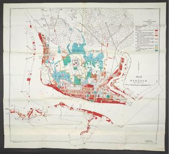
Comprising the most populous segment of the urban poor in Rangoon before the Second World War, Indian immigrants attracted much attention from planning authorities looking to improve their living conditions. A map of Rangoon in 1915 illustrates this focus on a specifically Indian poor from the outset of urban improvement in Rangoon (Figure 1). As part of the report that called for the creation of the RDT to clear ‘slums’ around the city, this map identified in solid orange ‘the poorer classes, largely Indian, in large or small tenements and huts & houses without compounds’.Footnote 35 Conflating Indians with Rangoon's poor, the map confirms that the areas scheduled first to be cleared by the RDT are those inhabited by Indians in the east of the city, towards Pazundaung Creek. Fifteen years later, after a decade of similar RDT schemes, a statement of objects and reasons for a Rangoon Labour Housing Bill argued that ‘a large number of Indian workpeople would be thrown on the streets’ unless ‘the strict enforcement of the Municipal bye-laws governing lodging houses . . . were coupled with the provision of additional accommodation’.Footnote 36 Along with the statement of objects and reasons, the commissioner of the Irrawaddy Division further illustrates this conflation, having written about the Rangoon Labour Housing Bill that ‘in the first place the origin of this problem of deficiency housing in Rangoon is ex hypothesi an Indian cooly problem’. Continuing that ‘without them [the Indian coolies] the problem would be nothing like so serious, and would probably not require the intervention of the Provincial Government at all’, the commissioner further demonstrated the emphasis authorities placed on improving Rangoon's urban environment of poverty vis-à-vis improving the conditions facing Indian immigrants working as temporary and unskilled labourers.Footnote 37
A 1915 map of Rangoon indicating the socio-economic divisions in the city.

While unskilled and semi-skilled labourers born in India attracted attention from government and local planning officials, the duration and nature of these immigrants’ stay in Rangoon posed a challenge to the city's planning authorities. Improvement schemes completed by the BIT and BDD in Bombay were designed largely with workers from the city's mill industry in mind.Footnote 38 Though this kind of millwork would still have been classified as unskilled or semi-skilled labour in Bombay, the demography of poverty in Bombay then varied from Rangoon's urban poor. Rangoon's unskilled and semi-skilled Indian immigrants, overwhelmingly men, often came alone to the city and to Burma on short-term labour contracts.Footnote 39 In contrast, Bombay's urban poor tended to migrate back and forth from the countryside.Footnote 40 While many migrants did not bring their families to Bombay, some retained more conventional family structures—a point often discussed amongst housing and planning officials concerned about families overcrowding single room chawls.Footnote 41 The demography of Rangoon's poverty then necessitated adapting a Bombay model for a more transitory and less conventionally structured population.
The adaptations of this model in Rangoon can be seen in efforts to focus on regulating ‘lodging houses’ meant for more temporary and transitory labour as well as enforcing mandatory requirements guaranteeing each person floor space in shared accommodation for the poor.Footnote 42 A report by members of the Rangoon Social Service League submitted as part of the 1927 public health report highlighted the problems of lodging houses, noting that, on Godwin street, ‘the sleepers swarmed out from the rooms like bees from a hive’. Documenting cases of overcrowding, the report also stated that there were, ‘for example, 25 where 11 were supposed to be; 31 where 11 were supposed to be, etc.’.Footnote 43 It also describes the ventilation in these houses as ‘non-existent’ and continues on that the ‘general filth is indescribable’.Footnote 44 Apart from the report by the Social Service League, the main body of the public health report concluded that ‘the exhalations from overcrowded, sweating humanity lying actually on top of one another, and breathing the same foul atmosphere over and over again, must be sufficient to turn the strongest stomach’.Footnote 45 While this emphasis on the housing conditions for more mobile labourers itself suggests an adaptation of the Bombay model, the report's conclusions represent another adaptation to Rangoon's environment, namely that constructing housing was largely left to private means while Trust monies were instead spent on developing communications (i.e. roads and thoroughfares) and preparing house sites.Footnote 46
The fact that this report was completed seven years after the foundation of the RDT and continues to describe these problems of housing the city's poor in ways reminiscent of the period before the work of the RDT is perhaps the strongest evidence of an adaptation of a pre-war Bombay model. Though a minority of the public health report's authors, represented by Narayana Rao, argued that ‘providing cheap sanitary dwellings to the poor and working classes’ was an integral part of ‘the improvement and expansion of the City of Rangoon’ with which the RDT was charged, the majority agreed that ‘there never was any intention that the Trust should provide buildings’.Footnote 47 Arguing that preparing house sites and constructing communications constituted a means through which Rangoon was improved and expanded, the majority position largely informed the policy decisions of those on the RDT and in Rangoon's municipal government. Though Rao articulated that ‘no one has come forward up to now to undertake the construction of dwellings for labour’, his points ultimately did not push the RDT to take up its own housing schemes.Footnote 48
Even in this less direct method of tackling the problem of housing, the RDT faced calls to be more determinate. The Rangoon Social Services League, which strongly argued, along with Rao, that the RDT should take a more active role in constructing housing, noted that, even on an estate where the RDT had constructed roads and prepared housing sites, ‘there remain many old houses whose construction is very faulty, the general sanitation for which can be described as hopeless’. Suggesting that ‘something more comprehensive is needed which will have to include something like small model dwelling houses’, the League advocated for a stronger role for the RDT in intervening in the living conditions of Rangoon's poor.Footnote 49 Rao and the Social Services League were not the only residents of Rangoon noting that the RDT did not live up to its potential. In a letter translated from Burmese as evidence submitted as part of the public health report, Maung Ba Kyaing, a landowner in Rangoon, expressed that ‘the poor classes are not benefitted by the work of the Rangoon Development Trust’.Footnote 50
This divide that had developed in the 1920s over the work of the RDT continued to be a point of debate into the 1930s. A report on the effects of removing rent-control measures in Rangoon, the controls themselves modelled off of measures adopted in Bombay, highlighted again the views of a minority advocating for the construction of chawls for the poor in the city.Footnote 51 While the main text of the report noted that, by December 1929, a local government committee ‘is in favour of the erection of chawls and recognizes that they could only be built and rented at a financial loss’, it went on to say that that the committee writing the report ‘is unable to favour this suggestion which amounts to subsidizing, at the expense of the general tax-payer of the municipality, certain classes of buildings’.Footnote 52 Though this argument represents an evolution of the position against adopting a Bombay model of construction housing for the poor, it ultimately precluded the large-scale construction of chawls in Rangoon before the Second World War.
Despite the report on rent in Rangoon effectively blocking the RDT from adopting more aggressive anti-poverty measures, evidence submitted by residents of Rangoon as part of testimony for the report demonstrates a public displeasure with a lack of improvement in the city's housing stock, particularly for the poor. Mr S. N. Thakker, a resident at 93/151-155 Fraser Street, gave testimony to the committee about his eviction from his unit and argued that ‘of all the hardships a poor man has to experience in Rangoon, the cruelty of the landlords is the worst’. Explaining the process of his eviction, Mr Thakker, who had lived at the Fraser Street address for almost 15 years, noted that he was asked to leave ‘because he had made a complaint’ about the ‘considerable repairs’ that the house needed.Footnote 53 Dr P. A. Nair, a resident at 207–209 Lewis Street, described ‘many cases where more than one family is sharing the same flat’ and that there was ‘more overcrowding since the removal of rent control’.Footnote 54 Maung Kywin Gyan, a resident of the Tatmye Quarter in Pazundaung, testified that tenants paid double in his quarter for the only available leases: ‘squatter leases’. He described that the ‘sanitation is bad’ and the ‘water supply inadequate’ in his neighbourhood and continued that there was a lack of electric lighting and ‘very defective’ drainage.Footnote 55
Mr S. A. A. Pillay, a pleader in Rangoon, offered testimony on the systemic rent increases that hit the city's tenants, documenting cases in the city's iconic Sofaer's building where rent increased by 40 per cent.Footnote 56 Mr C. K. Tambe, another lawyer in Rangoon, charged that the RDT increased ground rents in East Rangoon ‘by as much as 300 per cent to 400 per cent’ and argued that increases in rent had caused overcrowding and ultimately a spike in cases of tuberculosis.Footnote 57 Mr Tambe was not the only one linking disease and death to overcrowding, Mr C. Thoy, the Secretary of Rangoon's Tenants Association, outlined a similar argument in his deposition to the committee.Footnote 58 For those living in Rangoon's poorer neighbourhoods or for those representing them, the removal of rent-control measures demonstrated the lack of improvement and lack of commitment to improve housing stock for the poor living in the city.
Their testimony stood in stark contrast to those like the Municipal Assessor, Mr C. B. Rennick, who testified that limiting the number of people staying in lodging houses by putting ‘coolies in sanitary buildings’ would call into question whether ‘economic’ or profitable ‘rent will ever be obtained from them’.Footnote 59 Even the dissenters who generally advocated for a more expansive role of government in developing housing for Rangoon's poor noted that ‘we do not see how it is possible in the near future to contemplate the erection of chawls’ because of problems supplying enough water.Footnote 60 In this way, then, the report on rent controls in Rangoon illustrates the obstacles facing the city in adapting a Bombay model of urban development around poverty to a Burmese context.
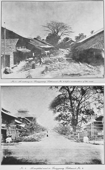
While chawls were ultimately never constructed in Rangoon before the Second World War, the RDT's works laying out roads and developing lands along the edges of the city constituted both the adaptation of a Bombay model of urban development built around poverty as well as the construction of an imperial urbanism in Rangoon. Despite the hurdles facing the development of tenement housing for working-class Rangoon, the RDT did engage in a number of more successful endeavours before the Second World War. Two pictures taken from the 1926–27 annual report of the RDT are a testament to the kind of work carried out by the RDT (Figure 2).Footnote 61 The left image shows the Sangyaung settlement during ‘road works’ while the right picture shows the same settlement after the completion of the RDT's works. Though the captions mentioned only ‘road works’, it is clear the images are meant to convey more a sense of general improvement. The left image depicts thatched roof houses and a curved street winding down the middle of the image in contrast to the rightmost image. Capturing the tiled roof buildings, straight streets with signage, drainage channels, and manicured vegetation pushed to the edges of the road, the rightmost image exemplifies the RDT's reclamation works around the city and illustrates visions of a reclaimed Rangoon.
Pictures from before and after the completion of works around the Sangyaung settlement, Rangoon, carried out by the RDT from 1926 to 1927.

The structure of Rangoon's labour market meant lodging houses for single, male, Indian labourers attracted the most attention from municipal and government authorities. As Osada has pointed out, this emphasis on a specifically Indian poverty in Rangoon inflamed racial tensions in the city at a time when Burma and Rangoon were experiencing some of the most violent protests in the late-colonial period.Footnote 62 Though a Bombay model of urban development loomed large in the minds of officials in Rangoon before the Second World War, the onset of the Japanese invasion shifted the attention of the city eastwards. As the events of the war forever changed Rangoon, a new post-imperial urbanism continued to be informed by the Bombay model and imperial urbanism that had dominated both the minds and the landscape of the city's urban environment during the early twentieth century.
Pivoting east to Hong Kong and Singapore for a new urban model of development after the Second World War
The Japanese Christmas Day bombings in 1941 and the Allied bombings to recapture Burma in 1944 left Rangoon in shambles.Footnote 63 The city's slow recovery was compounded by an unstable political situation—in the span of 11 years, Burma was separated from India, captured by the Japanese and made into an independent client state, recaptured by the Allies and ruled by a military administration, briefly reintegrated into a British imperial framework, and then granted independence.Footnote 64 To complicate things further, Burma's independence sparked a series of armed conflicts that have continued to the present day.Footnote 65
The destruction and political instability in Burma largely mirrored the destruction and political instability more widely in what was Japanese-occupied Asia. From wars for independence in Indonesia and Vietnam to a civil war in China, the post-war situation drew the newly independent Burmese authority's attention eastwards. While cities in India, like Bombay, had historically been points of comparison for administrators in Rangoon, cities like Hong Kong and Singapore—which faced their own post-war problems—quickly became points of comparison and reference for a reeling and reconstructing Rangoon.Footnote 66
This section argues that Rangoon's officials looked eastward, particularly to Hong Kong and Singapore, in devising strategies for both rebuilding the city and dealing with the renewed problems of slums and squatters as a result of ongoing conflicts in Burma. Given that both Singapore and Hong Kong had also looked to Bombay as a model for urban development before the war, this section suggests the emergence of a post-imperial urbanism that reflected changing politics in Asia and across the globe, but also demonstrated influences of the pre-war imperial urbanism that had previously dominated Rangoon.
Though before the war Rangoon most clearly looked to Bombay for sanitation strategies and policies to tackle urban slums and squatter resettlement, municipal authorities did sometimes compare Rangoon to other cities in what is now thought of as Southeast Asia. A section of a 1926 public health report compared the number of malarial deaths in Singapore to those in Rangoon. Noting that the size of the population of Singapore was ‘almost exactly the same as Rangoon’, the report suggests an attempt by municipal authorities to draw points of comparison between the two cities.Footnote 67 Noting that, while ‘it would appear that malaria is not sufficiently bad to justify . . . anti-malarial works’ in Rangoon, ‘a great deal of money has been spent in Singapore and a great improvement effected’.Footnote 68 While Rangoon ultimately did not embark on extensive anti-malarial public works, the report illustrates how examples of other Asian cities were used to influence contemporary debate over the future of the city. Though Singapore-style works were not adopted at the time, they were clearly suggested as an effective strategy for bringing down new malaria infections in the future.
The use of Singapore as a relevant point of comparison for authorities in Rangoon became more pronounced in the post-independence period. As Burmese authorities looked for ways to rebuild Rangoon, they struggled with an influx of refugees from across Burma fleeing the armed conflicts. Owning only what they could carry while fleeing the violence, these refugees often became squatters on the sides of Rangoon's roads, building small bamboo huts for temporary shelter. This problem of squatting along the side of the road and on other dangerous sites around the city attracted the attention of municipal authorities in the early 1950s. They commissioned a joint report between the Government of the Union of Burma and the RDT on the housing problem in Rangoon.Footnote 69
The report laid out the extent of the housing problem. It estimated that there were around 25,000 huts on open spaces, municipal lands, and private property around Rangoon. Compounding the problem were reports of overcrowding in these huts as well as in the pucca area—the brick-and-mortar downtown area—of the old city. To combat these problems, the report outlined the need for a survey of quotidian conditions in Rangoon as well as an extensive town plan that could begin to accommodate the city's burgeoning size. Including as an annex a 1920s report on the housing problem in Singapore, the Rangoon report demonstrates that Burmese officials were looking specifically to Singapore as model for post-war Rangoon.Footnote 70
In the main text of the report, officials clearly drew conclusions from the Singaporean case, noting the costs per head of constructing tenements in Singaporean dollars and then converting them to figures denominated in 1950s Burmese currency. Going on to argue that ‘good housing is, however, a good investment, even though it may not give “economic returns”’, the report cited that house rent in Singapore, regardless of wealth, did not usually exceed 15–20 per cent of income. In raising the issue of affordability and ‘uneconomic rents’, the Rangoon report reflected a consideration of Singapore's house-building efforts and an analysis of their success.Footnote 71
In addition to analysing the recent history of housing in Singapore, the conclusion of the report on the housing problem in Rangoon called for a ‘small technical committee’ to visit Singapore and Jakarta to ‘see and have explained the work done there’. Specifically, the report called for ‘house and tenement building in Singapore’ to be studied.Footnote 72 The 1951–52 report on the housing problem in Rangoon therefore illustrates a shift eastward in comparing and coping with Rangoon's problems.
Beyond studying Singapore, this eastward shift can also be substantiated by documents in the Hong Kong Public Records Office detailing a visit by the Mayor of Rangoon to Hong Kong in 1952.Footnote 73 Taking place contemporaneously to the investigation into conditions and solutions in Singapore, the Mayor of Rangoon and a few Burmese government officials over four days viewed about a dozen sites relating to Hong Kong's public infrastructure.Footnote 74 Expressing to K. M. A. Barnett, the Chairman of Hong Kong's Urban Council, that his chief interest lay ‘in the problem of water supply, refuse removal and resettlement of squatters’, the mayor pointed out that these interests were ‘problems of pressing importance of his own Municipality’.Footnote 75 Drawing a link between Hong Kong and Rangoon's challenges, the delegation toured public water works and hospitals, saw squatter settlements at Blue Pool and resettlement areas at Ching Man, as well as visited the Hong Kong Housing Society at Sheung Li Uk and land reclamation works in Happy Valley along Stubbs Road.Footnote 76 Apart from viewing these sites, closing remarks made by Barnett reiterated the common purpose of the delegation's visit:
It has been evident during our conversations that despite many external differences, Hong Kong and Rangoon do share a number of problems in common. Both suffered extensive damage during the war and experienced a long occupation by hostile forces; both have difficulty in supplying sufficient potable water to a dense urban population; both have difficulty in the disposal of urban refuse and both are attempting to solve it by reclamation schemes. Both suffer from a shortage of housing and it gave me a glow of fellow feeling to hear Your Worship describe the problem presented in Rangoon by squatters and the policy of resettlement outside the town which your administration is pursuing.Footnote 77
Barnett's closing remarks point to the extent to which Burmese and Hong Kong officials thought that solutions to Rangoon's problems lay in looking at Asian cities farther east than more traditionally looking west to India and Europe. They capture a growing sense of commonality that arose as a result of being captured and occupied by Japanese forces during the war as well as from facing the refugee crises resulting from violent conflicts in Burma and mainland China.
Seen in conjunction with Rangoon official's desire to study the case of Singapore, the Burmese delegation to Hong Kong can be seen as a sort of eastward pivot in how municipal authorities in Rangoon imagined the future development of their city. Though Bombay's chawls had previously been a lens through which the housing problem was conceptualized in Rangoon, the focus on Hong Kong and Singapore demonstrates an eastward-leaning reconceptualization of urbanism in the Burmese context. It also points to the emergence of a post-imperial urbanism that emerged in Hong Kong, Rangoon, and Singapore after the war. While not directly influenced by the British metropole, post-independence policies in Rangoon meant to tackle slums and resettle squatters were still largely framed in the context of the imperial urbanism of the preceding decades.Footnote 78 In this way, a new post-imperial urbanism developing in East and Southeast Asia in the 1950s and 1960s was contiguous with and built upon an India-centred imperial urbanism developed in the late nineteenth and early twentieth centuries.
Applying a post-imperial urbanism to post-war Rangoon until 1962
While the previous section of this article argued that the municipal and planning authorities in post-war Rangoon firmly placed themselves within the milieu of an emerging post-imperial urbanism in Asia, this section will demonstrate how these officials applied this post-imperial urbanism to planning and constructing settlements around the city. It will begin with a brief discussion of the transition from an imperial to a post-imperial urbanism during the transition from the British Military Administration (BMA) to an independent Burma from 1944 to 1948. The section will then focus on post-independence source material, previously unavailable to historians and made accessible by the National Archives of Myanmar in July 2014, which points to the development of satellite towns around the edges of Rangoon as the most prominent manifestation of an Asian post-imperial urbanism.Footnote 79 In constructing satellite settlements on the edges of the city from the end of the war until the military coup d’état in 1962, municipal officials not only reflected on, but also cemented, the physical and spatial legacies of a post-imperial urbanism on Rangoon's urban environment.
The transition from an imperial to a post-imperial urbanism in Rangoon coincided with a period of political transition in Burma. Though the BMA in Burma was interested in rebuilding the city's infrastructure and stabilizing living conditions for those flocking back to Rangoon, it lacked the resources to make a significant impact on improving the war-torn city. Despite the efforts of BMA Welfare Department in Burma, a shared name with the Army's Welfare Services that focused on the ‘provision of such luxuries and amenities as could be permitted in active service conditions’, misconceptions ‘regarding the scope and functions of the new department’ persisted and ‘there was in consequence a tendency to attach unduly low priority to its needs’.Footnote 80 In contrast to the Malayan Planning Unit, which operated in London for years before the reoccupation of Malaya, Burma's Welfare Department, which was in time renamed the Relief and Labour Department, worked only intermittently during the war to plan Burma's reoccupation.Footnote 81 Still, the BMA in Burma did attempt to provide shelter through an Accommodation Committee set up in Rangoon as well as appoint C. B. Rennick, the former Municipal Assessor, to manage Civil Affairs in Rangoon as a precursor to re-establishing the Rangoon Corporation.Footnote 82 Through a series of ‘dispersal centres’ and ‘permanent camps’, the BMA also attempted to provide shelter for displaced persons and refugees in Rangoon and across Burma.Footnote 83
When the RDT was reconstituted along with a civilian government in 1946 following two years of military administration in Burma, its Chairman, U Chit Maung, argued that ‘the clock has been set back by many years’ and ‘if therefore, under normal conditions there was justification for the continued existence of the Trust for the completion of various schemes, the case for its continuance under the present abnormal conditions is much stronger than anytime in the past’.Footnote 84 The reconstitution of the RDT in 1946 coincided with a renewed interest Rangoon's built environment, particularly as it related to living conditions for the city's poorest residents.
As had been the case before the war, Burma's post-war administrators continued to view Indian immigration as linked with poverty in Rangoon. Arguing that Indian immigration would make ‘the accommodation position even more difficult’ in the city, one of the government's secretaries ‘enquired if Government proposed to control the numbers [of Indian immigrants] by fixing quotas or otherwise’.Footnote 85 While viewing Indian immigration as at the heart of an accommodation shortage in the Rangoon represents continuity from the pre-war situation, the enquiry into the possibility of adopting measures restricting Indian immigration to Burma represents a shift. These meeting notes point to a new attitude amongst administrators that migration around the Bay of Bengal was not anymore a given and that flows and influxes of immigrants could potentially be controlled.Footnote 86
In addition to addressing concerns about Indian immigrants returning to Rangoon, the reconstituted RDT began in 1947 to focus on housing for populations displaced by the Second World War and ongoing conflict in Burma. While the Trust did not often construct structures for these displaced populations, it did at least attempt to create habitable conditions in Rangoon by clearing roads and providing drainage.Footnote 87 Though the post-war RDT did not succeed at ameliorating Rangoon's harsh living conditions in the short term, it did begin to develop plans for the coming decade. In line with an emphasis on social welfare in Singapore and Malaya in the aftermath of the Second World War, the actions of the RDT echoed larger concerns amongst post-war British officials concerned with the spread of communism in what was Japanese-occupied Asia.Footnote 88 While the RDT was replaced by a National Housing and Town and Country Development Board in 1951, the emphasis on social welfare continued.Footnote 89 With the immediate aftermath of the war behind them and more resources at their disposal, newly independent Burmese officials at the National Housing and Town and Country Development Board pursued this social welfare agenda by framing issues of housing and accommodation in a new way—through the development of satellite towns.
Satellite towns emerged as a key tool in Asian cities, like Hong Kong, for accommodating a burgeoning urban population. Concerned by high-population density figures relative to European and North American cities, post-war urban planners looked to developing along the edges of urban centres to spread out urban populations. Given the connections made before the war between urban congestion and epidemic disease, reducing urban density was seen as essential in developing sanitary cities.Footnote 90 Reports from Hong Kong in the 1950s on how to best develop low-cost housing exemplify these concerns over density. A report of the Reform Club of Hong Kong concluded that ‘on density figures alone, slum clearance is of vital and immediate importance’. In building the case for this conclusion, the report calls estimates of 12.8 square feet of living space per person in the Western District of Hong Kong ‘horrifying’.Footnote 91 In addition to reducing urban density, satellite towns also provided a cost-efficient way to spread out urban populations. Given that land prices, as a result of speculation, had impeded improvement trust efforts in Bombay leading up to the First World War, buying unused land on the urban fringe represented the surest way to control overall development costs.Footnote 92 Satellite towns in the Asian context then developed in the post-war period out of a need to house the influx of urban residents both inexpensively and in a way that reduced urban density.
Though this emphasis on reducing urban congestion in cities like Hong Kong was justified through population figures, satellite towns emerged in post-war Rangoon in spite of a survey concluding that the congestion ‘cannot be considered serious’.Footnote 93 The construction of satellite towns in Rangoon is then less rooted in discussions of conditions in the city as much as in discussions of other Asian urbanisms and regional strategies to tackle squatter settlements and slum redevelopment.Footnote 94 The 1954 survey of social conditions in Rangoon asserted that ‘the development of large fringe areas may not be as essential in the improvement of living conditions in Rangoon as it would be in the more congested areas of other Asiatic cities’ and yet municipal authorities continued to favour satellite towns as a means of redevelopment into the 1960s.Footnote 95 This dominance of satellite towns and decentralization in Rangoon's urban planning began under Burma's democratic government and continued through to military rule from 1958 to 1959 and then again after 1962.
This emphasis on congestion, decentralization, and satellite towns is demonstrated in Burma's period of democratic governance by plans for the construction of the Ba U township to be located across the river from downtown Rangoon at Dalla.Footnote 96 While Dalla had been considered a site for redevelopment as far back as the 1920s, U Nu's government commissioned American consultant John G. Claybourn in the 1950s to draw up plans that provided ‘modern housing accommodation together with religious and civic center areas’.Footnote 97 Claybourn's plans, which included workmen's quarters for 2,560 government labour employees, substantiated concerns of ‘unsightly, insanitary and unhealthy development’ in Dalla.Footnote 98 Reflecting perhaps his experiences working in Latin America, Claybourn suggested a ‘Panama Canal design’ for housing in Dalla—a design that was both ‘adaptable’ and ‘comfortable’.Footnote 99 Claybourn's plans for Dalla highlight the contiguous relationship between an imperial urbanism and Rangoon's post-war-built environment. Based largely on the practices of an imperial urbanism, post-imperial urbanism in Rangoon often borrowed and adapted plans from other imperial and transnational contexts.
Dalla's development as a satellite town of Rangoon in the early 1950s is not the only manifestation of post-imperial urbanism on the city. Under the direction of General Ne Win, who was handed control over Burma's central government from 1958 to 1959, satellite town construction was drastically expanded, at least as told by the regime's propaganda publication Is Trust Vindicated?. On the sites of three satellite towns—North Okkalapa, South Okkalapa, and Thaketa—the military regime claimed to have laid out over 32,000 house plots accommodating an estimated 141,000 people.Footnote 100 Documenting access to health clinics, medical services, roads, drains, and water—though not electricity or sewerage—these satellite towns were represented as an improvement for many of Rangoon's refugee residents. While the buildings themselves were constructed out of bamboo and other timber supplied by the Army and did not fare well in the monsoon and cyclone seasons—168 houses were noted as destroyed in the course of one year in South Okkalapa alone—they were still touted as an alternative to the ‘dwellers of the hutments which has mushroomed all over the City during the years after the War’.Footnote 101 Though this piece of propaganda likely oversold the military government's successes, the framing of these projects—as satellite towns complete with many modern amenities not unlike those in Hong Kong or Singapore—expresses the influence that a nascent post-imperial urbanism had on urban development projects in Rangoon.
Beyond the spectacle of constructing the satellite towns at Okkalapa and Thaketa, their target populations—mostly families fleeing the upheaval of Burma's ongoing conflicts—reflect the changing priorities of post-independence realities. While RDT officials had enquired into the possibility of ending Indian migrations to Burma, the democratic and military governments had made these enquiries a reality.Footnote 102 These development projects then were built with another population in mind—namely families fleeing the ethnic violence of post-war Burma. If the aim of these satellite towns—to house specifically refugee families—does not itself illustrate a shift in policies geared towards accommodating Rangoon's poorest residents, the names of the satellite towns North and South Okkalappa called back to well-known Barmar lore.Footnote 103 This change in the objectives of housing—primarily in the imagination of those deciding what kind of person would be housed—illustrates in part a difference between the influences of a post-imperial urbanism as compared to an imperial urbanism. While an imperial urbanism had been designed to mitigate the problems of migratory populations, a post-imperial urbanism instead focused on managing the challenges associated with an influx of refugee families—a challenged shared by cities like Hong Kong and Singapore as well.Footnote 104
Both the debates around and the development of housing for the poor in Rangoon and Burma shifted markedly after the Second World War. While Rangoon's municipal and planning officials read about, studied, and visited Hong Kong and Singapore for inspiration on how to tackle Rangoon's population of slum dwellers and squatters, they also physically constructed new settlements and satellite towns along the lines of those in Hong Kong and Singapore in the post-war period. Though Bombay's model had proved influential in Rangoon and Singapore during the late-colonial period, a new model developing in Hong Kong and Singapore, which both adapted and expanded upon Bombay's model, came to frame debates around and the construction of a built environment of urban poverty in Rangoon.
Rangoon and an Asian urbanism
This article has illustrated the extent to which and the ways in which debates about housing the poor in Rangoon were influenced by an emerging Asian urbanism. Though this urbanism was initially associated with the imperial project in Asia and was transmitted through a model tackling poverty through urban development that emerged in and emanated from Bombay, a post-imperial urbanism began to take shape in Hong Kong, Rangoon, and Singapore after the Second World War. Based around solutions to a shared set of problems associated with wartime destruction, refugee influxes, and poverty, this post-imperial urbanism remained contiguous with and influenced by the Bombay model and pre-war urban development. After all, the SIT, which became a model institution for Rangoon and Hong Kong after the war, had itself been ‘set up along the lines of the Improvement Trusts in Bombay’.Footnote 105
In locating Rangoon's history of urban development with respect to housing within the wider networks of trade, diaspora, and politics that shaped the city in the early and mid-twentieth century, this article has built upon the work of Sunil Amrith, Nile Green, Tim Harper, and Su Lin Lewis.Footnote 106 Beyond reconnecting the city to more accurately reflect its history of integration with the Bay of Bengal and the wider Indian Ocean, this analysis has begun to address a historiographical ‘lumpiness of cross-border connections’ that has developed in the study of port cities and oceanic connections.Footnote 107 While scholars have tended to focus on connections emanating from certain cities and territories, particularly those that are wealthier and better connected in the present, other cities and places, like Rangoon and Burma, have received relatively little academic attention. In a similar manner, this article has also spanned a gap in Indian Ocean studies that tends to fracture along the division of the Bay of Bengal and the Arabian Sea.
In understanding how an Asian (post-)imperial urbanism shaped and modelled an urban environment of poverty in Rangoon, this article has also demonstrated the ways in which a Burmese and a South Asian identity diverged over the twentieth century while the county and urbanites in Rangoon increasingly identified as Southeast Asian after the Second World War.Footnote 108 Showing that the shifting demography of poverty in Rangoon corresponded with changing regional and national identities, this analysis has demonstrated a way in which urban poverty helped to reshape and reform a Burmese identity.
In addition to a reshaping and reforming of identities, this article has also examined ways in which Rangoon's poor had a meaningful influence on the development of the city. While the city's poor were viewed by planners, politicians, and officials as critical to securing particular visions for the future, poor residents themselves also actively participated in the machinery of planning and policy to communicate their own experiences and positions. The archival material underpinning this article's analysis, which includes testimony translated and experiences transcribed from illiterate sources into English in order to be relevant to government committees, demonstrates the determination with which poor people and advocates for the poor approached contesting policies aimed at lessening poverty and inequality in Rangoon.