Introduction
Great timber longhouses are a defining feature of the first Neolithic communities in Central and Western Europe, belonging to the Linearbandkeramik (LBK) culture of the later sixth millennium cal BC (Coudart Reference Coudart1998). Even in the first recorded phase of longhouse construction (belonging to the LBK ‘formative’ phase), many elements of this architecture, such as longpits, side ditches and internal post rows, were already present (Bánffy Reference Bánffy, Hofmann and Smyth2013). During the succeeding (or earliest) LBK, buildings could be substantial, up to 20m or so long by 6m wide (Stäuble Reference Stäuble2005). From the later LBK onwards, in the Flomborn, Ačkovy, Notenkopf and Keszthely phases, which began c. 5300 cal BC, some longhouses reach over 30m in length and become more elaborate internally, with the typical internal cross-rows of three posts changing to any number of combinations and layouts (Modderman Reference Modderman1970; Coudart Reference Coudart1998). Many settlements have been found, each characterised by larger and smaller groupings of longhouses.
Despite their high archaeological visibility, wide distribution and thousands of excavated examples, many questions remain about these iconic structures. Where did this architecture first emerge? In the virtual absence of preserved floors, what can be said about the use of the interiors? How long did these buildings last, given the substantial oak posts with which the majority of them were framed? How did houses relate to their neighbours? What did variation in house size mean in terms of household composition? Should each house be considered an independent unit, or was household membership distributed across more than one building?
Consideration of such questions was long framed by the Hofplatzmodell, or independent homestead model. This model emerged from pioneering, large-scale rescue excavations on the Aldenhovener Platte in north-west Germany (Boelicke et al. Reference Boelicke, von Brandt, Lüning, Stehli and Zimmermann1988). It is based on a complex set of arguments founded upon a combination of site layouts, horizontal stratigraphy, ceramic sequences constructed through correspondence analysis of decorative motifs on fineware pottery and an inferred house duration of some 25–30 years (summarised in Zimmermann Reference Zimmermann, Kreienbrink, Cladders, Stäuble, Tischendorf and Wolfram2012). The model posits that each longhouse existed in its own space and is separated from irregularly spaced neighbours by a wider area that includes an activity zone spanning approximately 25m (in the case of Langweiler 8: Boelicke et al. Reference Boelicke, von Brandt, Lüning, Stehli and Zimmermann1988). With each succeeding generation, these loose house clusters shifted slightly. Any given community thus comprised a combination of independent households, or groupings of such households, as seen at Vaihingen, south-west Germany, or at Cuiry-lès-Chaudardes, northern France (Bogaard et al. Reference Bogaard, Krause and Strien2011; Hachem Reference Hachem2011).
More recently, the Hofplatzmodell has been strongly criticised (Rück Reference Rück, Hofmann and Bickle2009, Reference Rück, Kreienbrink, Cladders, Stäuble, Tischendorf and Wolfram2012). In its place, and principally on the basis of visual inspection of settlement plans, settlement layout based on rows of closely spaced longhouses aligned long side to long side has been proposed. Concurrently, differing hypothetical house durations up to and exceeding 75 years have been suggested (Schmidt et al. Reference Schmidt, Gruhle, Rück, Freckmann and Gronenborn2005: 162; Rück Reference Rück, Hofmann and Bickle2009). A wide range of row layouts were proposed, essentially covering the LBK areas in Central and Western Europe. Other studies, particularly in the eastern part of this distribution, support the revision of the independent homestead model, without accepting all elements of the row model, or necessarily following the proposed alternative estimated house duration (Lenneis Reference Lenneis, Kreienbrink, Cladders, Stäuble, Tischendorf and Wolfram2012; Marton & Oross Reference Marton, Oross, Kreienbrink, Cladders, Stäuble, Tischendorf and Wolfram2012). Other variations, such as linked house pairs and other close-set clusters, have also been proposed (Czerniak Reference Czerniak, Amkreutz, Haack, Hofmann and van Wijk2016).
The chronology of neither the Hofplatzmodell nor its alternatives, however, has been formally modelled (although note Lenneis Reference Lenneis, Kreienbrink, Cladders, Stäuble, Tischendorf and Wolfram2012). The site of Versend-Gilencsa in south-western Hungary forms the focus of this paper. It provides an opportunity to examine jointly issues of layout and chronology, as it shows clear row layout and has produced large assemblages of faunal remains suitable for radiocarbon dating.
Longhouse architecture and settlement layout in western Hungary
Archaeological research on LBK sites in western Hungary has intensified over the past two decades. By 2010, more than 300 houses from 50 sites were known (Oross Reference Oross2013: 151–77, tab. 5.1, fig. 5.10, 401–402). The real number of excavated house plans is, however, much higher, as numerous discoveries remain unpublished. Their architecture is generally similar to contemporaneous houses in other regions of Central Europe.
The excavated house plans from later sixth-millennium cal BC settlements in western Hungary form clusters arranged into rows that are usually roughly parallel to each other. Each row consists of two to six houses with their long axes perpendicular to the row. Very similar settlement layout can be observed on large LBK sites of the region, with some rows located close to each other, as at Tolna-Mözs (Marton & Oross Reference Marton, Oross, Kreienbrink, Cladders, Stäuble, Tischendorf and Wolfram2012: 225–33, fig. 3). Elsewhere, as at Balatonszárszó-Kis-erdei-dűlő, there were some open spaces between the house rows (Oross Reference Oross2013: 320–45). The nearby Szederkény-Kukorica-dűlő settlement shares the same layout, although the house units were principally associated with early Vinča- and Ražište-style pottery (Jakucs et al. Reference Jakucs, Bánffy, Oross, Voicsek, Bronk Ramsey, Dunbar, Kromer, Bayliss, Hofmann, Marshall and Whittle2016).
Versend-Gilencsa
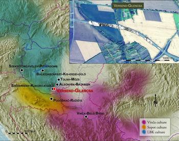
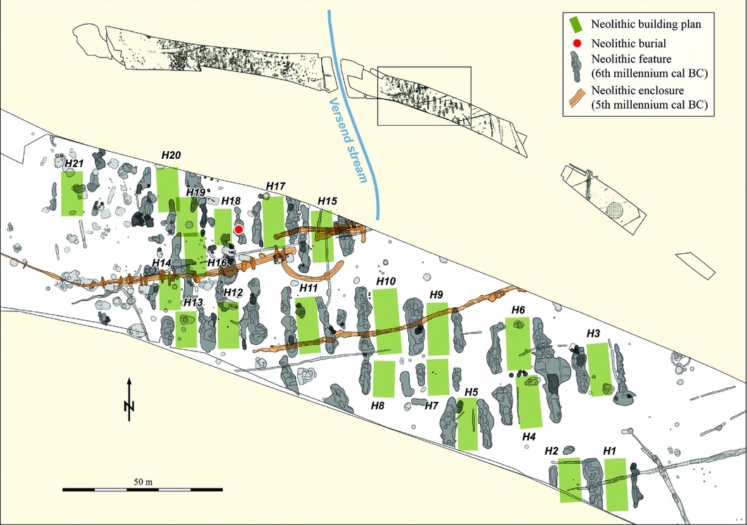
The large archaeological rescue excavation at Versend-Gilencsa (Figure 1) was carried out in 2006–2007 by archaeologists from the Janus Pannonius Museum, Pécs. The site lies in the area of the southern Baranya hills of Transdanubia, south of the village of Versend and less than 3km to the east of Szederkény-Kukorica-dűlő (Jakucs et al. Reference Jakucs, Bánffy, Oross, Voicsek, Bronk Ramsey, Dunbar, Kromer, Bayliss, Hofmann, Marshall and Whittle2016). A 1.2km-long strip, totalling over 6.5ha, was excavated. The Neolithic settlement extends over low, gently sloping ridges (Figure 2) on both sides of the Versend stream.
Map showing the location of the principal sites mentioned in the text.

Layout of the eastern part of the Versend settlement, with at least four rows of longhouses clearly visible.

In the eastern part of the Neolithic settlement, close to the stream, there were numerous traces of longhouses, oriented north–south. Although the postholes of these structures were poorly preserved, house plans could be identified from the characteristic longpits flanking the buildings. In this part of the site, at least 21 Neolithic house plans were identified, clearly arranged in at least four rows and nearly perpendicular to the streamline (Figure 2). Only one Neolithic burial was found here.
The western part of the site is more densely packed with features of different archaeological periods. Some were identified as potential Neolithic longpits due to their form. The locations of the suspected Neolithic houses are yet to be detected, due to later disturbance. This part of the settlement, however, yielded 24 burials, which were mainly cut into larger pit complexes and appeared to form small clusters. Most of the burials were in a crouched position, but none had associated grave goods.
Material culture
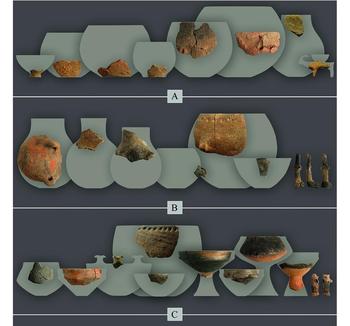
A varied range of pottery styles was found at Versend, including Vinča, Ražište, early LBK and Starčevo (Figure 3). Starčevo was the first Neolithic cultural grouping in Transdanubia, dating to the first half of the sixth millennium cal BC. New evidence from Versend and other south-east Transdanubian sites has shown that inherited elements of the Starčevo pottery style could have persisted longer than previously assumed (Marton & Oross Reference Marton, Oross, Kreienbrink, Cladders, Stäuble, Tischendorf and Wolfram2012). Vinča is the major post-Starčevo cultural grouping to the south of the LBK, the earliest manifestations of which date to the late fifty-fourth century cal BC (Whittle et al. Reference Whittle, Bayliss, Barclay, Gaydarska, Bánffy, Borić, Draşovean, Jakucs, Marić, Orton, Tasić, Schier and Vander Linden2016: fig. 25). The Ražište style, an early variant of the north-east Croatian Sopot culture (on the fringes of the early Vinča culture), may have resulted from interaction between the Vinča and LBK spheres (Marković Reference Marković2012). Additionally, decorative elements of the Malo Korenovo type (a regional variant of the LBK in northern Croatia and south-west Hungary; Težak-Gregl Reference Težak-Gregl1993) also occur.
The range of pottery styles and other material recovered from the eastern part of Versend: A) Starčevo; B) early LBK; C) Vinča.

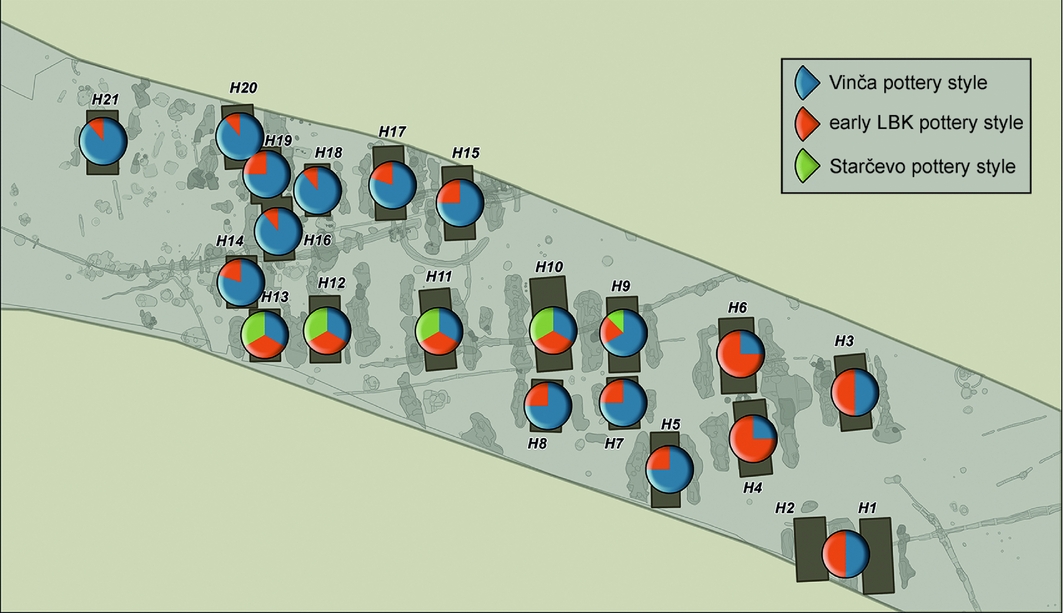
Early Vinča-style ceramics, figurines and bone tools are the dominant artefact types found in the buildings of the northern house row of the eastern settlement area, especially in houses H15 and H17 (Figure 4). In most houses, however, early Vinča-style vessel forms and technological markers occur together with early LBK-style ceramics (and in the cases of H3, H5, H7 and H15, with figurines as well), and also in some cases with material that appears to recall the Starčevo tradition (H10, H11 and H12). Analyses to date suggest relatively strong Vinča influences in the material culture of some houses in the eastern area of Versend, whereas other houses in the eastern area show stronger affiliations to the rest of Transdanubia (Figures 3–4). Ongoing post-excavation analysis has provided a different picture for the western side of the settlement. Although distinctive, early Vinča elements, such as black burnishing, black-topped vessels and red-slipping, are numerous, there were significant differences in vessel forms and decorative techniques. The vessel forms and applied decorative patterns are most analogous to the Sopot-Ražište-style ceramics of eastern Slavonia. Additionally, decorative elements of the Malo Korenovo pottery style are more frequent in this part of the site.
The proportions of different pottery styles by row and longhouse in the eastern part of Versend.

Radiocarbon dating
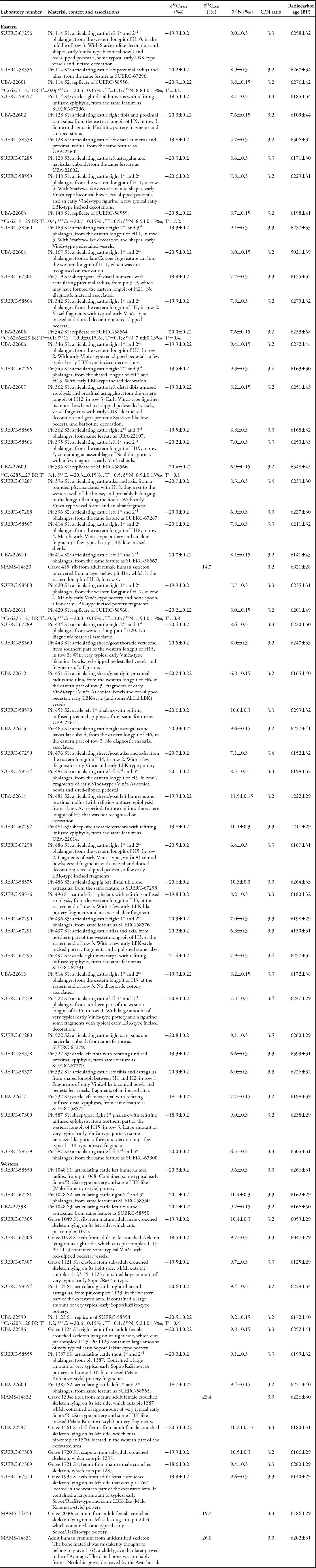
The radiocarbon dating programme for Versend was designed using Bayesian chronological modelling (Buck et al. Reference Buck, Cavanagh and Litton1996), incorporating the four Mannheim radiocarbon dates on human skeletons that had been obtained previously (MAMS, in Table 1). The sampling strategy aimed to date the occurrence of longhouses and Vinča ceramics on the same site, to explore the layout of the eastern part of the settlement and to determine whether occupation at Versend was contemporaneous with that at nearby Szederkény-Kukorica-dűlő.
Radiocarbon and stable isotopic measurements from Versend-Gilencsa. Replicate measurements have been tested for statistical consistency and combined by taking a weighted mean before calibration, as described by Ward and Wilson (Reference Ward and Wilson1978; T′ (5%)=3.8, ν=1 for all).

Sampling was concentrated on the eastern part of the settlement where the layout of the buildings could be reconstructed. A small number of samples were dated from the western area to check that both areas were occupied simultaneously. The entire faunal assemblage from the eastern part of the site was assessed for groups of articulating bones and bones with re-fitting unfused epiphyses (cf. Bayliss et al. Reference Bayliss, Beavan, Hamilton, Köhler, Nyerges, Bronk Ramsey, Dunbar, Fecher, Goslar, Kromer, Reimer, Bánffy, Marton, Oross, Osztás, Zalai-Gaál and Whittle2016: fig. 7). This material must have been rapidly deposited after death for the elements to remain articulated. Strictly, such samples provide a terminus ante quem for the construction of each longhouse. It is probable, however, that the chronological difference between the deposition of the dated animal bones and house construction is relatively small as none of the recovered material came from the upper parts of features (the top 0.4m was mechanically removed prior to excavation).
Sixty-eight radiocarbon measurements are available from Versend, all on samples of articulating animal or human bone (Table 1). Technical details of the results and the methods used to produce them are provided in the online supplementary material (OSM).
Modelling the chronology of the Neolithic settlement at Versend-Gilencsa
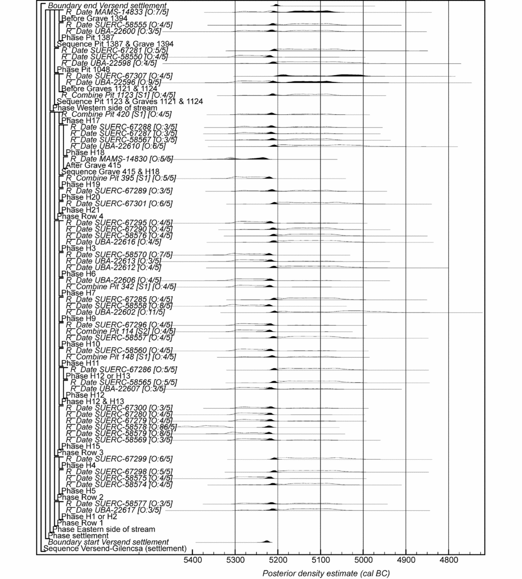
Chronological modelling was undertaken using OxCal v4.2 (Bronk Ramsey Reference Bronk Ramsey2009a; Bronk Ramsey & Lee Reference Bronk Ramsey and Lee2013) and the calibration dataset of Reimer et al. (Reference Reimer, Bard, Bayliss, Beck, Blackwell, Bronk Ramsey, Buck, Cheng, Edwards, Friedrich, Grootes, Guilderson, Haflidason, Hajdas, Hatté, Heaton, Hoffmann, Hogg, Hughen, Kaiser, Kromer, Manning, Niu, Reimer, Richards, Scott, Southon, Staff, Turney and van der Plicht2013) (the model algorithms are defined exactly by the OxCal CQL2 code provided in the OSM). The structure of the preferred model (Model 4) is illustrated by the brackets and OxCal keywords on the left-hand side of Figures 5 and 6 (http://c14.arch.ox.ac.uk/). The outputs from the models, the posterior density estimates, are shown in black, and the unconstrained calibrated radiocarbon dates are shown in outline. The other distributions correspond to aspects of the model. For example, the distribution start Versend settlement (Figure 5) is the posterior density estimate for the time when the settlement at Versend was established. In the text and tables, the highest posterior density intervals of the posterior density estimates are given in italics.
Probability distributions of dates from the settlement at Versend; each distribution represents the relative probability that an event occurs at a particular time. Posterior/prior outlier probabilities are shown in square brackets. The structure of the model is shown by the brackets and OxCal keywords down the left-hand side of Figures 5 and 6. The model is defined exactly by the OxCal code provided as online supplementary material (Versend_Model_4.oxcal).

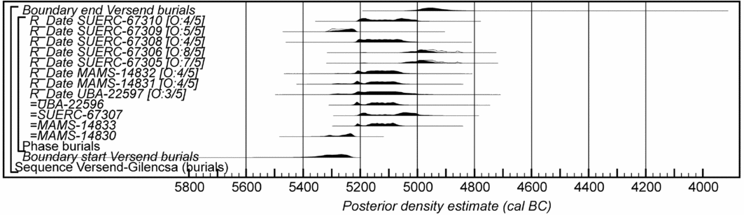
Probability distribution of dates from burials at Versend. Format as for Figure 5. The structure of the model is shown by the brackets and OxCal keywords down the left-hand side of Figures 5 and 6. The model is defined exactly by the OxCal code provided as online supplementary material (Versend_Model_4.oxcal).

A number of alternative models for understanding the chronology of Versend have been constructed. They all include the limited number of stratigraphic relationships between dated features (grave 415 is earlier than pit 414 of H18, pit 1123 is earlier than graves 1121 and 1124, and pit 1387 is earlier than grave 1394). Replicate radiocarbon measurements are combined by taking a weighted mean (Ward & Wilson Reference Ward and Wilson1978) before calibration and inclusion in the models, and the three measurements on intrusive samples of post-Neolithic date are excluded.
Model 1 (Versend_Model_1.oxcal) includes all of the settlement features and burials in a single, continuous uniform phase of activity (Buck et al. Reference Buck, Litton and Smith1992). It has poor overall agreement (Amodel: 46; Bronk Ramsey Reference Bronk Ramsey2009a: 356–57), with burials 1049 (SUERC-67305) and 1078 (SUERC-67306) clearly continuing later than the dated settlement. Model 2 (Versend_Model_2.oxcal), therefore, places the settlement features and the burials in separate, potentially overlapping, continuous uniform phases of activity (cf. the model structures illustrated in Figures 5 and 6). This model has poor overall agreement (Amodel: 56) and poor overall convergence (C: 85), with three samples having poor individual agreement (Bronk Ramsey Reference Bronk Ramsey1995: 429; UBA-22596, A: 42, UBA-22602, A: 46 and SUERC-58578, A: 1). A variant of this, Model 3 (Versend_Model_3.oxcal), which splits the settlement into its eastern and western parts, has good overall agreement (Amodel: 63) but poor overall convergence (C: 83), with the same three measurements having poor individual agreement (A: 44, A: 47 and A: 4 respectively). SUERC-58578 is statistically significantly earlier than the other measurements on similar samples from the longpits of H15 (T’=20.4; T’(5%)=11.1; ν=1; Ward & Wilson Reference Ward and Wilson1978), and indeed is clearly earlier than all the other dated samples from the site (see Figure S1). Given its articulation, it appears unlikely to be residual from an earlier feature and so is probably a laboratory outlier.
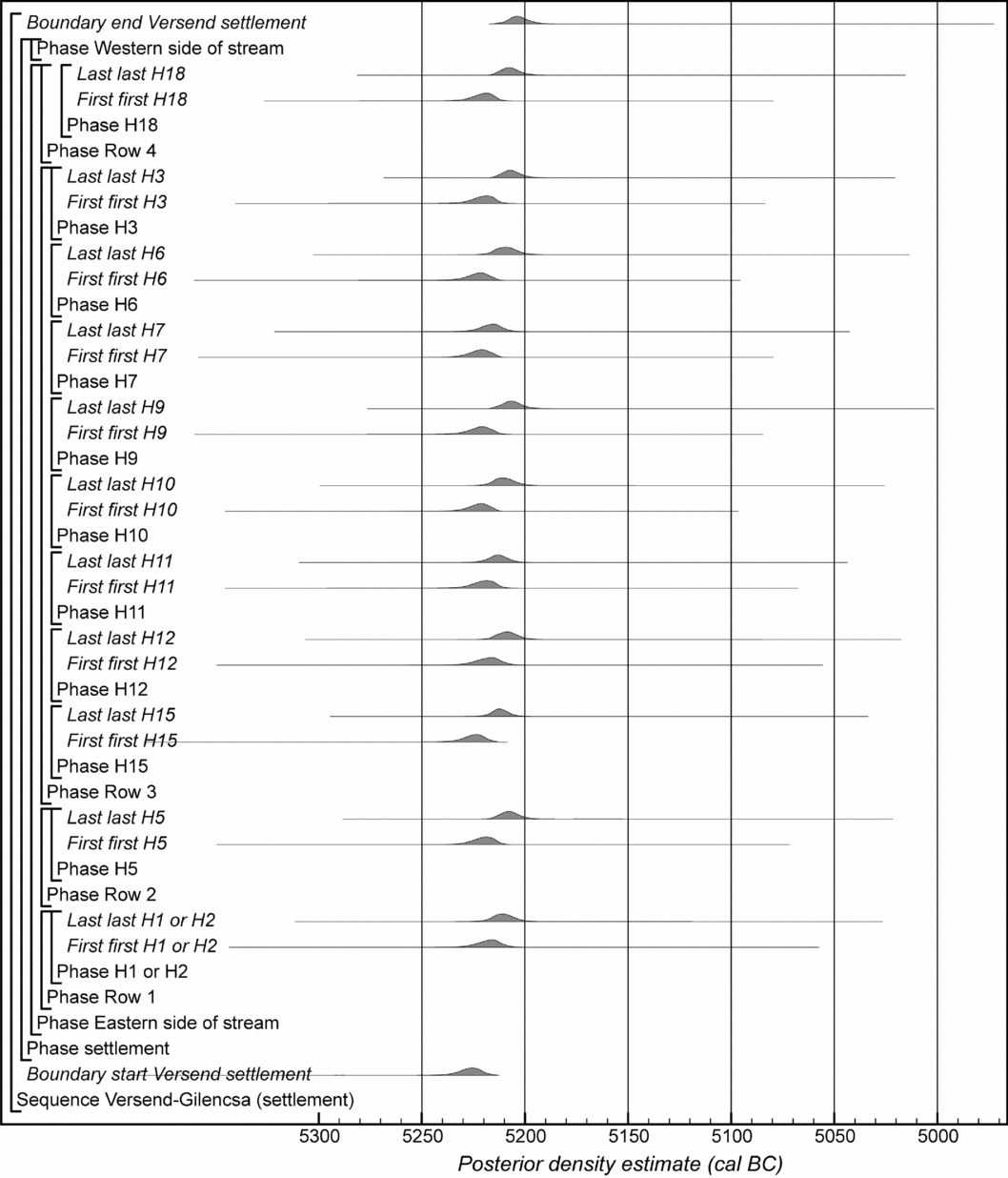
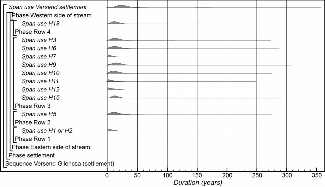
Model 4 (Versend_Model_4.oxcal), therefore, implements outlier analysis to identify and proportionally weight any statistical outliers arising from unquantified laboratory error in the data (Outlier_Model(“SSimple”,N(0,2),0,“s”); Christen Reference Christen1994; Bronk Ramsey Reference Bronk Ramsey2009b). This model is identical in form to Model 2, but implements s-type outlier analysis in OxCal, with each radiocarbon measurement being given a prior outlier probability of 5%. Only SUERC-58578 (83%) and UBA-22602 (11%) have posterior outlier probabilities of more than 10%, and it is again clear that SUERC-58578 is a significant outlier from the main body of data from the settlement (the outlier analysis downweights this date proportionately). Model 4 is defined by the CQL2 code provided as OSM (Versend_Model_4.oxcal), although its overall form is illustrated in Figures 5 and 6. The first and last dated events have been calculated for each longhouse that has yielded more than two radiocarbon dates. The difference between them provides an estimate for the duration of use of each building, bearing in mind that the upper longpit fills are probably missing. These key parameters are illustrated in Figures 7 and 8, and their highest posterior density intervals are given in Table 2.
Key parameters for the first- and last-dated events for houses with more than one radiocarbon date, and for the establishment and abandonment of the settlement, derived from Model 4 (Versend_Model_4.oxcal).

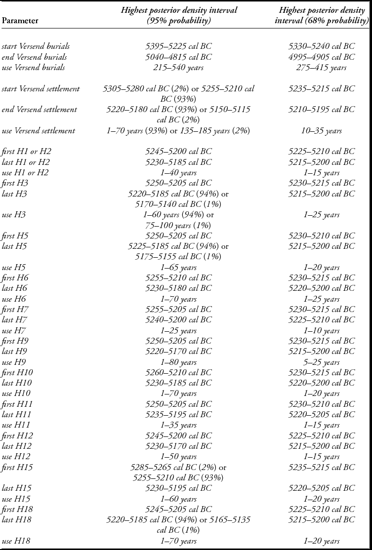
Highest posterior density intervals for key parameters from Versend-Gilencsa, derived from Model 4 (Figures 4–5).

Obtaining a statistically plausible and stable model for the chronology of Versend has been challenging, due to the shape of the radiocarbon calibration curve between c. 5300 and c. 5000 BC (Figure S1). This consists of two small plateaux separated by a pronounced wiggle, which leads to strongly bi-modal posterior distributions. Consequently, the models are extremely slow to converge or are unable to achieve adequate convergence at all (Bronk Ramsey Reference Bronk Ramsey1995: 429). The highest peaks of probability in all of our variant models, however, suggest a short-lived settlement occupied for a few decades around 5200 cal BC. As this coincides with a steep part of the calibration curve separating two small plateaux, we were concerned that our results could be an artefact of the shape of the curve. For this reason, we ran 14 simulation models identical in form to Model 1, each spanning 30 years and starting from 5270 BC–5130 BC. The posterior distributions produced by these simulations included the actual dates in accordance with statistical expectation (Table S1), and so we feel that the model outputs presented should be accurate to within the quoted uncertainty.
The model shown in Figure 5 suggests that the Versend settlement was established in 5305–5280 cal BC (2% probability; start Versend settlement; Figure 5) or 5255–5210 cal BC (93% probability), probably in 5235–5215 cal BC (68% probability), and was abandoned in 5220–5180 cal BC (93% probability; end Versend settlement; Figure 5) or 5150–5115 cal BC (2% probability), probably in 5210–5195 cal BC (68% probability). It was in use for 1–70 years (93% probability; use Versend settlement; Figure 8) or 135–185 years (2% probability), probably for 10–35 years (68% probability). Given the short overall duration of the settlement, most houses were probably in use for no more than a decade or two (Figure 8). Burial occurred for longer on the site, beginning in 5395–5225 cal BC (95% probability; start Versend burials; Figure 6), probably in 5330–5240 cal BC (68% probability) and ending in 5040–4815 cal BC (95% probability; end Versend burials; Figure 6), probably in 4995–4905 cal BC (68% probability). It continued for a period of 215–540 years (95% probability; use Versend burials; distribution not shown), probably for a period for 275–415 years (68% probability). This persistence in burial is in stark contrast to the brevity of settlement on the site.
Key parameters for the duration of houses with more than one radiocarbon date and the overall settlement, derived from Model 4 (Versend_Model_4.oxcal).

Discussion
Model 4 suggests not only short durations for individual longhouses in Versend-Gilencsa (median values not exceeding 20 years; Figure 8), but also, in complementary fashion, a short life for the settlement as a whole, in the late fifty-third century cal BC. Although fewer in number, dates from the western part indicate a similar period of use to the eastern part. The longer duration for burial on the site, although unusual in this type of context, does not conflict with the modelled brevity of settlement. In assessing the implications of these formally modelled estimates, we must restate the nature of our dated samples. Our short-life samples came mainly from pits flanking the longhouses in the eastern part of the settlement, and it is believed that those features were truncated over time. Furthermore, it is not entirely clear how the filling of these pits relates to the lifespan of individual buildings. Did these features fill up quickly? Were the finds in them foundational deposits? Were they recut periodically? These are questions that apply across the whole LBK distribution (cf. Stäuble Reference Stäuble and Lüning1997), and are therefore open to testing at other sites. Our proxy, however, is the best available for Versend-Gilencsa, and is probably the kind of proxy found in many other LBK contexts.
The estimated short house durations, therefore, have not only local significance (discussed below), but also potential wider implications for the debate concerning the forms and timings of LBK settlements. The eastern part of Versend-Gilencsa is unequivocally arranged in rows, as is probably the western part. This example—and plenty of others in Transdanubia and east-central Europe—therefore confirms the spatial dimension of the row model (Rück Reference Rück, Hofmann and Bickle2009, Reference Rück, Kreienbrink, Cladders, Stäuble, Tischendorf and Wolfram2012). Our date estimates for house longevity, however, conform well to the estimates produced by the Hofplatzmodell (Zimmermann Reference Zimmermann, Kreienbrink, Cladders, Stäuble, Tischendorf and Wolfram2012), and are considerably shorter than those proposed as a corollary of the row model. It remains to be seen, of course, whether similar results can be produced by formal modelling of other LBK longhouse settlements. The few other available formally modelled estimates for house duration in other Neolithic contexts generally support shorter rather than longer house lives. In the tell settlements of Vinča-Belo Brdo, Serbia, and Uivar, Romania, for example, median house durations range from 4–55 years and from 11–82 years respectively (Tasić et al. Reference Tasić, Marić, Filipović, Penezić, Dunbar, Reimer, Barclay, Bayliss, Gaydarska and Whittle2016: fig. 10; n = 10; Draşovean et al. Reference Draşovean, Schier, Bayliss, Gaydarska and Whittle2017: fig. 7; n = 8); many houses appear to have lasted from one to two human generations. All such estimates must be contextualised.
We have suggested that some houses in the early stages of tell development could have been deliberately abandoned to create memory and renown (Draşovean et al. Reference Draşovean, Schier, Bayliss, Gaydarska and Whittle2017), and that house life in the late stages of the Vinča-Belo Brdo tell could have been shortened by circumstances of very unsettled times (Tasić et al. Reference Tasić, Marić, Penezić, Filipović, Borojević, Borić, Reimer, Russell, Bayliss, Barclay, Gaydarska and Whittle2015). Precise dendrochronological dating suggests that short house lives (<20 years) were also the norm in the Alpine foreland (Hofmann et al. Reference Hofmann, Ebersbach, Doppler and Whittle2016). Although variation is possible, it appears probable that Neolithic housing was rarely long-lived, even when solidly constructed. If such estimates are robust, we need to consider the reasons why. That involves thinking not only about the individual house and household, but also the nature of communities and the specific circumstances in which they found themselves.
There seems no reason why, with adequate maintenance (especially of the roof), LBK longhouses could not have been long-lasting. Their shorter lives, if that is what they normally had, must therefore be due to the social context in which they were built and used. People may have relocated buildings (and indeed whole settlements) for a number of practical reasons, including escape from infestation and unsanitary conditions (Whittle Reference Whittle and Topping1997). There are also well-documented ethnographic cases where the death of household heads and the associated pollution are sufficient motive to abandon particular buildings (Whittle Reference Whittle and Topping1997). A well-known counter-example is the Zafamaniry house in Madagascar, which can endure in parallel with long-lasting marriage (Bloch Reference Bloch, Carsten and Hugh-Jones1995).
There is no specific evidence from individual houses at Versend-Gilencsa and rarely elsewhere that enables us to identify such influences. We must, however, consider flexibility and fluidity in household composition and durability, the wider context of groups of houses and the circumstances in which they were built and used. The closely set rows at Versend-Gilencsa surely project a strong sense of community. Evidence suggests that the rows were relatively fully populated at the same time; only a few relationships (for example, H19 and 20; H14 and 16; Figure 2) suggest successive building. Setting out rows of houses in the manner seen at Versend-Gilencsa—facing each other across narrow lanes and with their long sides very close to neighbours—was surely a deliberate act of community construction. Earlier settlement history in the region lends further support to this claim, when many occupation sites of both the Starčevo and Körös cultures might have had a less concentrated character (Bánffy et al. Reference Bánffy, Marton, Osztás, Kozłowski and Raczky2010). By analogy, whatever the situation may be with individual houses and households, it is probable that community was often fragile and divided; in settling in the same place, people probably had to work hard to stay together (Cohen Reference Cohen1985; Canuto & Yaeger Reference Canuto and Yaeger2000; Amit Reference Amit and Amit2002; Birch Reference Birch and Birch2013: 8). In the American Southwest, early Mesa Verde villages have been called ‘social tinderboxes’, which rarely lasted beyond 30–70 years (Wilshusen & Potter Reference Wilshusen, Potter, Bandy and Fox2010: 178).
While individual house lives in tell settlements may have often been relatively short, occupation of place was maintained for centuries (Tasić et al. Reference Tasić, Marić, Penezić, Filipović, Borojević, Borić, Reimer, Russell, Bayliss, Barclay, Gaydarska and Whittle2015, Reference Tasić, Marić, Filipović, Penezić, Dunbar, Reimer, Barclay, Bayliss, Gaydarska and Whittle2016; Draşovean et al. Reference Draşovean, Schier, Bayliss, Gaydarska and Whittle2017). There is good reason to assume that many ‘flat’ settlements, including plenty of LBK examples, lasted for considerable periods of time. Formal modelling suggests, for example, that the occupation of nearby Szederkény-Kukorica-dűlő lasted from the late fifty-fourth to the early fifty-second centuries cal BC (Jakucs et al. Reference Jakucs, Bánffy, Oross, Voicsek, Bronk Ramsey, Dunbar, Kromer, Bayliss, Hofmann, Marshall and Whittle2016); Tolna-Mözs, approximately 50km to the north along the Danube (Marton & Oross Reference Marton, Oross, Kreienbrink, Cladders, Stäuble, Tischendorf and Wolfram2012), provides another useful comparison. Szederkény, which combines the characteristically LBK longhouses with early Vinča-style pottery, was probably founded soon after the initial LBK ‘diaspora’ across Central Europe and beyond (Jakucs et al. Reference Jakucs, Bánffy, Oross, Voicsek, Bronk Ramsey, Dunbar, Kromer, Bayliss, Hofmann, Marshall and Whittle2016: fig. 24), and in circumstances of considerable social, cultural and demographic flux. This situation seems to have continued into the fifty-third century cal BC, given the range of ceramic styles seen at Versend-Gilencsa.
We must allow for the possibility that some villages ended much more quickly than others. In some cases, this may have been due to internal tensions, shifting alliances or external aggression. To date, there is no direct evidence from Versend-Gilencsa that allows us to identify specific factors, although the ceramic variability at the site could suggest the co-presence of social groups with diverse cultural backgrounds and allegiances; this mix might have produced difficulties in maintaining community. In assessing the relevance of the modelled estimates presented here for longhouses and site duration, the possibilities of premature ending or social failure, in contingent circumstances, must be kept in mind. It remains to be seen whether other row settlements will yield similar results. If rows at one level were synonymous with communal solidarity, it could be that households within them were also more prone to tension and fission, and therefore had shorter lives than the more independent and autonomous social units implied in the Hofplatzmodell.
Acknowledgements
Thanks to Boldizsár Csornay and Erzsébet Nagy for supporting our work in the Janus Pannonius Museum of Pécs; the Deutsche Forschungsgemeinschaft for funding the ʻBevölkerungsgeschichte des Karpatenbeckens in der Jungsteinzeit und ihr Einfluss auf die Besiedlung Mitteleuropas’ project, led by Kurt W. Alt and Eszter Bánffy; Kitti Köhler for her help with human bone identification; Éva Ágnes Nyerges and Hayley Foster for animal bone identification; and Zsolt Réti and Kirsty Harding for help with the figures. Dating and modelling were supported by an Advanced Investigator Grant (295412) of the European Research Council for ‘The Times of Their Lives’ (www.totl.eu), led by Alasdair Whittle and Alex Bayliss.
Supplementary material
To view supplementary material for this article, please visit https://doi.org/10.15184/aqy.2017.218