

1. Introduction
Water scarcity and water allocation in transboundary river basins have been among the most important emerging water management issues over the past decades, increasing demand for transboundary cooperation (e.g., Dinar, Reference Dinar2007; Dombrowsky, Reference Dombrowsky2007; Wolf, Reference Wolf2007; Bhaduri and Barbier, Reference Bhaduri and Barbier2008). The economic efficiency of transboundary water allocation management has mainly been picked up in the literature on hydro-economic modeling (e.g., Calzadilla et al., Reference Calzadilla, Rehdanz and Tol2011) and game theory (e.g., Ansink and Weikard, Reference Ansink and Weikard2012). In the economic valuation literature, the economic efficiency of water allocation is primarily related to water use in irrigated agriculture, the largest water consumer, particularly water pricing (e.g., Johansson et al., Reference Johansson, Tsur, Roe, Doukkali and Dinar2002; Dinar and Mody, Reference Dinar and Mody2004; Tsur, Reference Tsur2005) and irrigation water supply uncertainty (e.g., Rigby et al., Reference Rigby, Alcon and Burton2010). Only recently has the economic valuation of irrigation water been placed in a broader institutional-economic context of water rights and irrigation water governance (e.g., Speelman et al., Reference Speelman, Farolfi, Frija and Van Huylenbroeck2010; Veettil et al., Reference Veettil, Speelman, Frija, Buysse, Mondelaers and van Huylenbroeck2011).
In this study, we present the first valuation study of irrigation water supply in an international, transboundary setting. The main objective is to estimate farmer demand for improved irrigation water supply by focusing on two different solutions: a local one where irrigation water supply is secured through enhanced operation and management of irrigation water channels in Gezira, one of the largest irrigation schemes in the world; or an international one where irrigation water supply is secured through transboundary cooperation between the governments of Sudan and Ethiopia, who share the same river, the Blue Nile. Erosion from agricultural lands in the highlands of Ethiopia in the Blue Nile river basin causes serious sedimentation of waterways downstream, in particular the Gezira irrigation scheme. In Gezira, sediment deposition blocks water inlet pipes and gates, and reduces irrigation channel flow capacity, cropped area and crop yield (Ahmed et al., Reference Ahmed, Osman and Babiker2006). Siltation of the channel system is getting worse every year and the costs of keeping the irrigation channels open increase correspondingly. Over the past 10 years, it was estimated that on average 16.5 million m3 of sediment was removed at a total cost of more than US$12m (Gismalla, Reference Gismalla2009). Sustainable agricultural practices upstream, including soil conservation, are needed to protect downstream areas against sedimentation and improve the wellbeing of farmers at the same time (Merrey and Gebreselassie, Reference Merrey and Gebreselassie2011). Previous studies have shown that upstream farmers in Ethiopia are willing to invest in soil conservation, but that these farmers lack funding and are in need, among others, of access to credit (e.g., Tesfaye and Brouwer, Reference Tesfaye and Brouwer2012).
Alemayehu et al., (Reference Alemayehu, Hagos, Haileselassie, Mapedza, Gebreselasse, Bekele and Peden2008) assessed upstream and downstream farmer willingness to pay (WTP) for an integrated watershed management intervention that involved upstream and downstream farmers in two watersheds in northeast Ethiopia near Lake Tana using the contingent valuation method. The share of farmers who are not willing to pay for such an intervention in their study is high (35 per cent). Downstream farmers in both watersheds were also asked if they would be willing to compensate upstream farmers for the environmental services they provide. In this case, the refusal rate was lower (16 per cent), but it remained unclear exactly what farmers were being asked to pay for. Using more specific policy alternatives in a multi-attribute choice experiment, including the institutional context, is expected to produce more reliable and meaningful results.
In such a choice experiment, we present downstream farmers in Gezira with the possibility of paying an increase in existing irrigation fees to secure improved future irrigation water supply by either enhancing the removal of sediments in their local irrigation channels or compensating farmers in the Ethiopian highlands for taking soil conservation measures to prevent land degradation and soil erosion. In order to more efficiently use the scarcely available irrigation water, we also introduce water saving irrigation technology in the policy options in the choice experiment. In this way, we are able to evaluate downstream farmers’ preferences and WTP for transboundary cooperation, improved irrigation water supply, and new water saving technology.
The remainder of the paper is organized as follows. The theoretical choice model is presented in section 2, followed by the design of the choice experiment in section 3. Section 4 describes the case study area and the study implementation. Results are presented in section 5, first the farm household sample characteristics (section 5.1), followed by the farmers’ water needs and irrigation water use and use efficiency (section 5.2), then farmers’ attitudes toward and perception of transboundary cooperation and hydro-solidarity within the Gezira irrigation scheme in times of water shortage (section 5.3), and the estimated choice model based on the choice experiment (section 5.4). Finally, section 6 concludes.
2. The choice model
Farmer preferences are modeled in terms of McFadden's, (Reference McFadden and Zarembka1974) random utility model (RUM), allowing for a separation of utility
 $(U_{ijt}^{c})$
into a deterministic part (
 $V_{ijt}^{c} )$
and a stochastic part (
 $\varepsilon _{ijt}^{c} )$
. Choice experiments fall in the class of attribute-based methods in which the deterministic part of utility for individual i for an alternative irrigation water policy j in choice task t is described in equation (1) as a linear function of its attributes
 $X_{ijt} $
and other explanatory variables
 $Z_{ijt}$
(e.g., Train, Reference Train2003):
 $$U_{ijt} =V_{ijt} +\varepsilon _{ijt} =\beta X_{ijt} +\alpha Z_{ijt}+\varepsilon _{ijt}\quad \forall j\in D_{it}$$
In each choice task the farmer is presented with a limited set of policy proposals D it , each proposing an improvement in irrigation water supply at a certain cost. The stochastic term is assumed to follow an IID extreme value distribution of type 1.
Farmers are expected to differ in terms of the water shortage they face and their corresponding preferences for water supply and water use efficiency depending on their location within the Gezira irrigation scheme (upstream at the head or downstream at the tail). To account for such preference heterogeneity, the preference parameters for the attributes are allowed to vary across farmers, applying different mixing distributions. Equation (2) describes the mixed logit (ML) probability of farmer i selecting policy alternative j in choice task t over other policy alternatives k. The utility coefficients β vary across individual farmers (hence β
i
) with density
 $\Delta (\beta _{i} \vert b)$
. This density can be a function of any set of parameters and represents in this case the mean and covariance of β in the sample population.
 $$P_{ijt} =\int \left({\exp [(\beta_i X_{ijt} +\alpha Z_{ijt})] \over \sum_{j\in D} \exp [(\beta_i X_{{ikt}} +\alpha Z_{{ikt}} )]}\right) \Delta (\beta _i \vert b)d\beta _i \quad \forall j\in D_{it}$$
ML-models assume heterogeneity to be continuous over the interval spanned by the assumed distribution for the preference parameters (Scarpa et al., Reference Scarpa, Ferrini, Willis, Scarpa and Alberini2005). Treating preference parameters as random variables requires estimation through simulated maximum likelihood. Procedurally, the maximum likelihood algorithm searches for a solution by simulating draws from distributions with given means and standard deviations. Probabilities are calculated by integrating the joint simulated distribution. Recent applications of ML-models have shown that this model is superior to the standard multinomial logit model in terms of overall fit and accuracy of welfare estimates (e.g., Louviere et al., Reference Louviere, Hensher and Swait2003; Morey and Rossmann, Reference Morey and Rossman2003; Provencher and Bishop, Reference Provencher and Bishop2004).
ML-models account for farmer differences (preference heterogeneity) and repeated choices (Train, Reference Train2003). Even if unobserved heterogeneity is accounted for in a ML-model, the model may fail to explain the sources of heterogeneity (Hynes et al., Reference Hynes, Hanley and Scarpa2008). To this end, interactions of farmer-specific household characteristics can be included with choice-specific attributes in the utility function to improve the model fit (Revelt and Train, Reference Revelt and Train1998). We test to what extent data from repeated individual choices and between different geographical locations can be combined into an aggregate choice model using the Swait and Louviere, (Reference Swait and Louviere1993) test procedure. As part of this procedure, equality of scale parameters is tested. Scale parameters, and as a result choice variance, may differ across repeated choice sequences, for instance due to preference learning (Brouwer et al., Reference Brouwer, Dekker, Rolfe and Windle2010).
Finally, if a monetary cost attribute is included in the choice experiment, monetary welfare estimates can be derived (e.g., Hensher et al., Reference Hensher, Rose and Greene2005). The welfare measure represents the monetary value arising from a change in the bundle of irrigation water supply services.
3. Experimental design
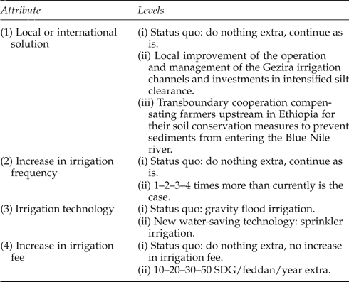
Choice experiments (CE) are based on the idea that a policy can be described in terms of its key characteristics and the levels that these characteristics take (e.g., Bateman et al., Reference Bateman, Carson and Day2002). It is these characteristics that are of particular interest here in relation to the design of an improved irrigation water supply policy based on transboundary cooperation. The basic experimental design consists of conventional attributes such as an increase in the availability of irrigation water, measured here in terms of increased irrigation frequency, and an increase of irrigation water use efficiency, measured here through the introduction of water saving irrigation technology. The benefits of improved irrigation water supply and water use efficiency are traded off against an increase in the irrigation water fee farmers currently pay. Hence, farmers are asked for their preferences for increased irrigation water supply frequency and improved irrigation water use efficiency by reducing the sediment loads in the Gezira irrigation channels and are asked whether they are willing to pay extra for this.
The tradeoff is embedded in a local and transboundary governance structure. It is this latter transboundary characteristic of addressing the sedimentation problem in the Blue Nile river basin that makes this experiment stand out compared to existing efforts to value irrigation water using stated preference methods. The international solution focuses on improved integrated soil and water management to sustain agricultural food production upstream and downstream, but is at the same time expected to yield important additional tangible downstream benefits, such as reduced flood damage and increased hydropower production due to reduced siltation of dam reservoirs, and intangible benefits in terms of strengthening transboundary institutional cooperation. The latter may in turn reduce tensions related to upstream-downstream water availability and allocation. An important question is to what extent the farmers in the Gezira scheme factored in these additional tangible and intangible benefits in their decision making during the choice experiment. The focus of the CE was purely on the improvement of irrigation water supply; possible additional benefits were not mentioned during the CE. Farmers were informed that this is a hypothetical situation that currently does not exist, and told that in order to facilitate transboundary collaboration, an international commission consisting of the relevant ministries in Sudan and Ethiopia would implement and carefully monitor the international transfer of funds to ensure both farmers upstream in Ethiopia and downstream in Gezira would benefit from this international cooperation. The local solution was found in improved management of the irrigation channels and intensified removal of the silt from the channels and waterways in the Gezira irrigation scheme. The increase in the existing irrigation fees was justified because of the increasing inflow of sediments in the past and the foreseen increase in the future, necessitating more frequent dredging of the irrigation channels than currently is the case.
The CE attributes and their levels are presented in table 1. The attributes and their levels were selected and specified based on a literature review, consultation of local experts, and on-site focus group discussions and pretesting. Water and land are owned by the government in Sudan. Most of the land used by the agricultural sector is leased to tenants or to private entrepreneurs, such as operators of large-scale mechanized rainfed farming (Omer, Reference Omer2011). Contrary to previous studies (e.g., Speelman et al., Reference Speelman, Farolfi, Frija and Van Huylenbroeck2010), private water rights were therefore not considered an appropriate characteristic in the experimental design here. Instead, water pricing was directly related to the increased availability of irrigation water supply and cost recovery. Poor cost recovery and its influence on the management of irrigation networks and the delivery of irrigation water services is a common problem worldwide (Ward, Reference Ward2010).
Attributes and levels used in the choice experiment

Due to the accelerated deterioration of the Gezira irrigation network, inadequate supply of irrigation water has been the rule rather than the exception since the 1990s, reducing the actual level of irrigation by land tenants below recommended thresholds (Saiih et al., Reference Saiih, Abdalla, Sidahmed, Fakl and Ismail1993). This implies longer intervals between irrigations, which under the existing climate conditions in Gezira restrict crop yields (Eldaw, Reference Eldaw2004). The amount of water needed to irrigate the land depends on the type of crops grown (mainly sorghum, groundnuts, cotton and wheat). Irrigation occurs through gravity-driven flooding of the land and improvements in irrigation water supply are therefore best understood by farmers as an increase in flood frequency. During the focus group discussions and pre-test, farmers mentioned that they currently flood their land, on average, five times during the year.Footnote 1 The recommended number of floods differs based on crop type, and lies in most cases one to three times above current irrigation frequency levels. The irrigation water supply improvements offered in the policy scenarios vary between 20 and 80 per cent (one to four times more often than the overall average of five times per year). The increase in irrigation water supply is guaranteed. Contrary to Rigby et al., (Reference Rigby, Alcon and Burton2010), uncertainty hence does not play a role in our design.
The water use efficiency of flooding is relatively low compared to modern irrigation technologies such as sprinkler and drip irrigation (e.g., Deng et al., Reference Deng, Shan, Zhang and Turner2006). These modern technologies require a reliable (constant) water supply and only perform if concentration levels of suspended soils are limited to avoid blocking of the tubes. Drip irrigation is even more sensitive to high sediment concentration levels than sprinklers. Despite certain advantages of drip irrigation over sprinkler irrigation, expert consultation led us to believe that drip irrigation was a step too far in the Gezira irrigation scheme. This is due to the substantially higher initial investment costs and higher per-hectare system operation costs in addition to the advanced technical skills required to operate and maintain such a system compared to sprinklers, which require less initial investment cost and less skilled labor for operation (Ali, Reference Ali2011). Moreover, the on-site focus group discussions showed that most farmers in the study area had heard of and were familiar with the advantages of sprinkler irrigation.
Finally, farmers currently pay a flat rate for irrigation water supply, in most cases to the local water users’ association (WUA), and in some cases to a government-owned company responsible for the distribution and marketing of the cash crops grown in the Gezira. The irrigation fee is based on the crops farmers grow, not on the amount of water they consume. Average water fees are lowest for lower value cash crops such as sorghum and groundnut, and highest for higher value cash crops such as cotton and wheat. The water fee farmers pay does not seem to bear a relationship to the scarcity costs of water. Compared to what the sampled farm households currently pay for irrigation water supply, the proposed change in irrigation water fees implies an increase between 15 and 100 per cent.
4. Case study area and survey implementation
4.1. The Gezira irrigation scheme
The Gezira irrigation scheme is located between the Blue and White Nile towards their confluence south of Khartoum (see figure 1). The scheme was established in 1925 when the Sennar Dam across the Blue Nile was completed (Plusquellec, Reference Plusquellec1999). In the period 1959–1963 the original Gezira Scheme was extended to include the Managil area. Combined, the Gezira and Managil schemes cover an area of about 882,000 ha under gravity irrigation (World Bank, 2000). The climate in the Gezira area is hot and arid with erratic rainfall that varies from north to south. The mean annual rainfall ranges from 400 mm/year in the southern part to 200 mm/year in the northern part, and is distributed over three months of the year (July–September). Relative humidity fluctuates from 18 per cent in the summer to 55 per cent in autumn and 28 per cent in the winter, while temperatures vary from 5°C in December to over 46°C in April, with an annual mean of 28°C (Mohamed et al., Reference Mohamed, Thiruvarudchelvan, Mamad, Mul and Van der Zaag2011). The soils in the irrigation scheme consist mainly of sediments of the Blue Nile, which are classified as vertisols and typically crack during droughts, and have a clay content of 50–60 per cent (Plusquellec, Reference Plusquellec1999).
Location of the Gezira irrigation scheme in Sudan and the interview locations

The Gezira irrigation area is flat with a gentle slope from south to north and from east to west, thus providing an ideal situation for gravity-driven irrigation flow. The scheme has around 102,000 tenants, who farm on average on about 8.4 ha of land. The land of each tenant is divided into four plots, on which cotton, wheat, sorghum or groundnuts are grown following a rotation system (Mohamed et al., Reference Mohamed, Thiruvarudchelvan, Mamad, Mul and Van der Zaag2011). The network of irrigation channels consists of a total of 2,300 km of main channels and about 1,500 minor channels with a total length of over 8,000 km (Plusquellec, Reference Plusquellec1999). The scheme produces 65 per cent of the country's cotton, 70 per cent of the wheat, 32 per cent of the sorghum, 15 per cent of the groundnut and 20 per cent of the nation's vegetables (Elhassan and Ahmed, Reference Elhassan and Ahmed2008).
4.2. Survey implementation
Primary data to estimate the choice model were collected via a farm household survey. Two hundred farmers in the Gezira scheme were interviewed in April 2012 in Arabic by trained local enumerators. Sampling of farmers was done following a randomized block design. The Gezira scheme was divided into four parts: head, tail, middle part and the extension Managil. Along the irrigation channels in each of these parts, two villages were randomly sampled and within each village 25 farmers. The position of the interview locations in the irrigation scheme is shown in figure 1. Zananda is the head of the scheme (upstream), Gamusia the middle part and Kab El-Gidad the tail (downstream). Prior expectations were that water shortage would be most severe further downstream. The scheme extension Managil was expected to be more modern and more efficient in terms of operation than the three locations in the original scheme due to its younger age.
The survey consisted of four main parts. The first part elicited general sociodemographic information about the farm household (e.g., age of the farmer, number of school years, number of household members, amount of farm land, etc.). The second part focused on the crops grown on the land, the inputs needed to grow the crops, including irrigation water, and the prices paid for these inputs. Part 3 was about farmer experiences with water shortages, their perception of the current situation in the area and any problems they experience related to farming in the Gezira, who they consider to be responsible for solving water shortage problems, and their solidarity with other farmers inside and outside the Gezira. Finally, part 4 introduced the CE.
Interviewers were trained to memorize a standard text, explaining that farmers would be shown a series of choice cards describing two policy alternatives each time, between which they would be asked to choose (including the option to choose neither of the two), characterized in terms of improved irrigation water supply and water use efficiency at the cost of increased irrigation fees in a local or transboundary water governance context. Attributes and their levels were depicted using pictograms in view of the fact that part of the sample population was expected to be illiterate. Each choice card was printed in color on a separate sheet of paper, laminated and bound together with other choice cards in a spiral binder for multiple uses. Before farmers went through the choice cards, they were first shown an example card to make sure that they had a clear understanding of the choice task at hand. An example of a choice card is presented in figure 2.
Example of a choice card

In view of the fact that farmers cannot be shown and asked to trade off all possible combinations of attribute levels, a D-efficient main effects statistical design was generated using the software Sawtooth. The design applied in this study consisted of 20 versions of nine choice tasks each. Each farmer was randomly shown one of these 20 versions. In order to be able to test choice consistency (e.g., Brouwer et al., Reference Brouwer, Dekker, Rolfe and Windle2010), the first card in each version was also shown again after the ninth card without telling the farmer. Hence, each farmer was shown a total of 10 cards and asked to select their most preferred policy alternative 10 times.
5. Results and discussion
5.1. General farmer characteristics
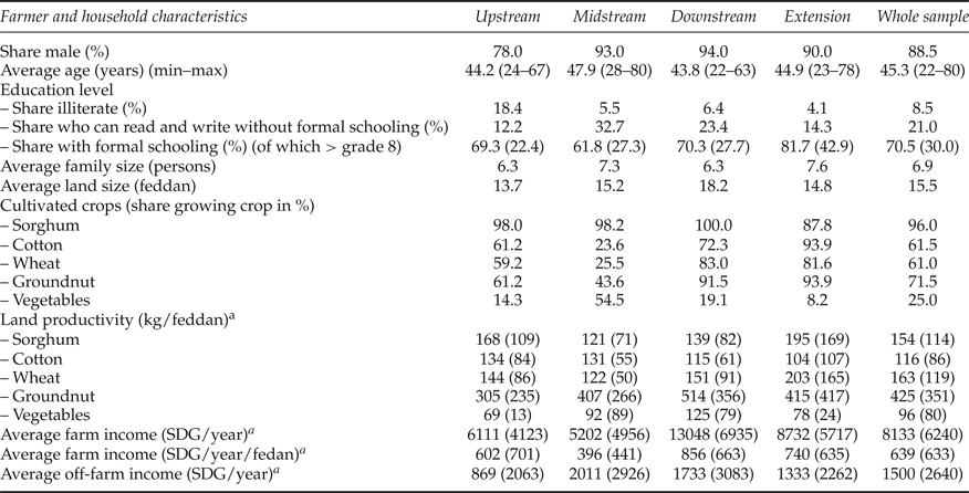
General farm household characteristics are presented in table 2. A distinction is made between the four locations where the data were collected: head, middle part, tail and the extension Managil in the western part of the irrigation scheme. Possible differences between the locations were tested using the non-parametric Kruskal–Wallis test. Test results are not shown, but are available from the authors upon request; when differences are statistically significant (at the 10 per cent level), this will be mentioned explicitly.
General farm household characteristics

Notes: a Standard deviation between brackets.
Most of the farmers who were interviewed were men, aged between 22 and 80 years, with an average age of 45 years, coming from a household consisting of six to seven family members. Although 30 per cent of the farmers did not go to school, a majority (>90 per cent) are literate. Downstream tenant farmers have significantly more land (33 per cent) than upstream farmers. The average land size across all farmers is 6.5 ha. This is almost 20 per cent more downstream (7.65 ha) and 10 per cent less upstream (5.75 ha). Almost all farmers grow sorghum, slightly less so in the extension part of the irrigation scheme, where cotton and groundnuts are the dominant cash crop types. Downstream farmers grow substantially more groundnuts and wheat than upstream farmers (and slightly more cotton), while vegetables are mostly grown by farmers in the middle part of the scheme. Land productivity is also significantly higher downstream for groundnuts, while productivity is significantly highest for sorghum in the extension part Managil. Cotton productivity is highest upstream at the 10 per cent level.
Finally, reported annual farm income differs significantly across the four locations, and is highest downstream of the irrigation scheme, per year (US$4,660) and per hectare (US$306), possibly due to the larger land plots in this part of the scheme and the relatively high land productivity, followed by farmers living in the extension of the scheme (US$3,119 and US$264, respectively). Farm income is lowest in the middle part of the irrigation scheme (US$1,858 per year and US$141 per ha per year), probably because of the relatively lower share of cash crops grown here compared to the other parts in the irrigation scheme. Although off-farm income is highest in the middle part of the irrigation scheme and lowest in the upstream part, no significant differences can be detected across the four locations.
5.2. Irrigation water use
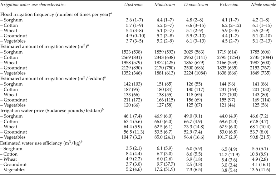
When asked how often they receive irrigation water, this differed significantly between crops and locations (table 3). On average, cotton was irrigated most frequently, followed by wheat. Sorghum was reported to receive irrigation water least often. The average number of times farm land was irrigated was lower than the generally recommended frequency in the area of seven to eight times per year.
Irrigation water use

Notes: a Minimum and maximum values between brackets. b Standard deviation between brackets.
When comparing flood irrigation frequency across locations in the irrigation scheme, downstream farmers reported higher irrigation frequencies than farmers located elsewhere in the scheme except for wheat. However, the observed differences were only found to be significant for sorghum and groundnuts. Correspondingly, the estimated amount of irrigation water farmers received (based on irrigation frequency and average duration of each flood irrigation) also differs, with downstream farmers growing sorghum and groundnuts receiving significantly more water than farmers growing the same crops elsewhere throughout the irrigation scheme. Again, cotton received the highest amount of irrigation water (2,735 m3 per year), this time followed by groundnuts (2,153 m3 per year) and then wheat (1,987 m3 per year). Sorghum received on average the lowest quantity (1,785 m3 per year).
Related to the amount of land farmers rent to grow their crops, cotton still receives significantly more water (479 m3 per ha) than any of the other crops, followed by groundnuts (402 m3 per ha). Vegetables received the lowest amount of water per unit of land (298 m3 per ha). However, no significant differences can be detected for the different cash crops across locations, except for wheat for which farmers in the extension part of Gezira received a significantly higher amount of irrigation water (421 m3 per ha) than farmers growing the same crop elsewhere.
The water fee farmers pay, on average, for the different types of crops per land unit differs significantly too. Farmers pay most for water to irrigate vegetables (US$77 per ha), followed by cotton and wheat (US$58 per ha), groundnuts (US$46 per ha) and finally sorghum (US$40 per ha). The fee differences are relatively small between locations, but nevertheless statistically significant for water used for sorghum, cotton and wheat. Downstream farmers pay most for water used to irrigate sorghum (US$42 per ha) and wheat (US$62 per ha), while farmers in the extension part pay most for water used for cotton cultivation (US$59 per ha).
Finally, it is also of interest to see how efficient Blue Nile water is to irrigate crops. This is presented in the bottom part of table 3. The water use efficiency differs across crops (except for vegetables) and locations. Groundnuts need the least water to produce 1 kg of this cash crop (4.1 m3), but the dispersion around the mean value is very high. Wheat is second in rank (4.9 m3 to produce 1 kg of wheat) and the spread around this mean value is much smaller than for groundnuts. Downstream farmers are most efficient in producing both of these crops. Upstream farmers are most efficient when using water for sorghum. To produce 1 kg of sorghum, they only need 3.5 m3 of Blue Nile water, while all the other farmers in the scheme need between 70 and 85 per cent more water to achieve the same level of output. Cotton is the most water-intensive crop in the Gezira scheme. On average, a farmer needs almost 11 m3 of water to produce 1 kg of cotton. However, significant differences here also exist across the scheme. Water use efficiency is highest in the middle part of the scheme, where relatively few farmers grow cotton, and lowest in the western extension part of the irrigation scheme where most farmers grow cotton. Farmers growing cotton in the extension part need more than twice as much water to grow the same amount of cotton as farmers living in the middle part of the irrigation scheme.
5.3. Water shortage perception and Blue Nile hydro-solidarity
When asking farmers what they considered to be the most important challenge related to farming in the Gezira scheme, most farmers (43 per cent) mentioned water shortage, followed at a distance by inadequate extension services (mentioned by 6 per cent of the farmers). Almost none of the farmers received the amount of irrigation water they claimed they need to grow their crops. More downstream farmers (81 per cent) than upstream farmers (65 per cent) mentioned water shortage as the main challenge. Furthermore, substantially more upstream farmers and farmers living in the middle part of the scheme mentioned sedimentation as the most important reason for water shortages (65 and 60 per cent, respectively), while most downstream farmers mentioned unequal water distribution (45 per cent) and too much water use at the head of the scheme (34 per cent) as the main reason. One in every five downstream farmers (21 per cent) mentioned siltation as the most important reason for water shortages. Sedimentation is considered a big problem by a majority of all farmers upstream, downstream and in the middle part of the irrigation scheme (57–73 per cent), but not in the extension Managil where 43 per cent consider sedimentation somewhat of a problem and 47 per cent a big problem.
When asking farmers further what they believe causes the sedimentation problems in Gezira, about one-third referred to farmers upstream in Ethiopia and just over half (53 per cent) mentioned the current management of the irrigation scheme. The share referring to Ethiopian farmers is higher in the extension Managil than in the other parts of the irrigation scheme. Awareness levels of upstream soil erosion problems are also much higher in the extension part than elsewhere in the scheme. Ninety-four per cent of the farmers living in the extension Managil are aware of the soil erosion problems further upstream in Ethiopia, while this share is 55 per cent at the head of the scheme and 66 per cent at the tail.
Farmers in the Gezira scheme feel very connected to each other, especially in terms of their willingness to share irrigation water during times of shortage. This sense of solidarity is highest in the extension Managil, where 86 per cent of the farmers feel this way, and lowest in the tail of the scheme, where 57 per cent recognize this sense of solidarity. When asked about their sense of transboundary solidarity, i.e., how connected they feel with farmers upstream in Ethiopia, a majority (64 per cent) reported not feeling any connection at all. Overall, less than 10 per cent felt very connected. This share is highest in the extension of the irrigation scheme (16 per cent). Between a quarter (middle part) and a third (extension) of the farmers in the Gezira felt somewhat connected. When asked whether they would be in favor of increased transboundary cooperation in the Blue Nile Basin to solve water shortage problems, almost all farmers in the Gezira scheme (97 per cent) answered positively. We found no indications that other additional benefits such as improved international collaboration in other fields between the two countries or reduced flood damage costs played a role in the farmers’ replies. Farmers focused only on their water shortage problem and the solutions offered through the policy alternatives, i.e., taking measures at the source instead of the receptor side. There exists a high degree of trust in international cooperation: over 70 per cent of all farmers believed that Ethiopian farmers upstream would implement soil conservation measures when compensated. Only 3 per cent did not believe this would actually happen, while a quarter were not certain. Almost all farmers would be willing to pay extra irrigation fees in principle if they got more irrigation water in return, indicating that what matters most to farmers is to have access to more irrigation water.
5.4. Estimated choice model and WTP for improved irrigation water supply
The positive attitude towards paying higher irrigation water fees in order to increase irrigation water supply and its use efficiency is also witnessed when examining the choice shares across the three alternatives in the CE. The first policy alternative was chosen in 50.6 per cent of the cases and the second in 48.7 per cent of the cases. Hence, as expected, no selection bias could be detected between the unlabeled policy alternatives. The opt-out was chosen in less than 1 per cent of the cases (0.7 per cent). Farmers are also consistent in their choice behavior: 87 per cent chose exactly the same policy alternative at the end of the choice experiment in the tenth choice task when they were shown the same choice card again as the one they answered at the start. This is a relatively high share compared to results found elsewhere in the literature (e.g., Brouwer et al., Reference Brouwer, Dekker, Rolfe and Windle2010). Pooling choices in the choice sequence in three groups of three choices and testing their equivalence using the Swait and Louviere, (Reference Swait and Louviere1993) test procedure shows that the choice attribute parameters are significantly different, which may be due, for instance, to learning.Footnote 2
There is, however, almost no change in choice model error variance, indicating that the accuracy of the choices remains more or less the same throughout the choice sequence. Hence, farmers’ preferences for the choice attributes seem to change as they go through the choice sequence, possibly because of learning and their unfamiliarity with the CE exercise at first, but not the degree of variation in choices and error variance. This may also be related to the fact that there is such a high choice consistency rate. People did not make random choices, but their preference structure does change in the choice sequence.
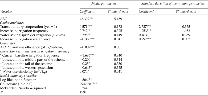
The estimated choice model is presented in table 4. The choice attributes were included as random variables in the model in order to account for possible preference heterogeneity. The estimated random parameters logit model accounts for the panel data structure of the CE, i.e., where each respondent made nine different choices. For efficiency purposes, the model was estimated using a Halton sequence of 100 replications in a quasi-Monte Carlo maximum likelihood simulation (Bhat, Reference Bhat2001). The model is highly significant as can be seen from the outcome of the model χ2, with a high pseudo-R 2 for this type of cross-section panel data analysis of 74 per cent. There is one missing observation for one of the covariates included in the model; hence the reason why the number of observations is 1,791 (nine choices for 199 farmers). In our search for a statistically best fit model, a large number of possible models were estimated based on different variable combinations. The covariates presented in table 4 remained consistently significant.Footnote 3 The dummy variables for all the locations in the irrigation scheme were included in the model in table 4 (the upstream location being the baseline category) even though not all were statistically significant, since this was one of the objectives of the study to test for spatial (upstream-downstream) variation in irrigation water demand within the Gezira scheme.
Estimated choice model

Notes: Significance levels: ***, 1%; **, 5%; *10%.
All choice attributes are statistically significant at the 5 per cent significance level and have the expected signs. Farmers value transboundary cooperation significantly higher to reduce siltation of the irrigation channels than to improve local irrigation water channel maintenance and management. They furthermore positively value an increase in irrigation frequency and prefer sprinkler irrigation over and above the current flood irrigation. As expected, they have a negative disposition towards higher irrigation water fees. The significant positive outcome of the alternative specific constant (ASC) related to the two hypothetical policy alternatives implies that farmers prefer a change instead of no change from the current situation. The results in the top right corner of table 4 show that we find preference heterogeneity across individual farmers for three of the four choice attributes. Only the distribution of the random parameter related to the new water saving irrigation technology is not statistically significant. The increase in irrigation frequency and water fee are included in the model in table 4 as linear effects coded variables and their random parameters follow a normal distribution, while a uniform distribution is used for the random parameters related to the two dummy variables, as recommended in the literature (Hensher et al., Reference Hensher, Rose and Greene2005).
Turning to the covariates measuring observed preference heterogeneity in table 4, we find significant reference dependency, meaning that farmers value an increase in irrigation water availability less if they already have more frequent access to irrigation water (measured by the interaction between the attribute ‘increase in irrigation frequency’ and current baseline irrigation frequency). Farmers living in the western extension of the Gezira scheme value an increase in irrigation frequency significantly less than farmers living at the head of the scheme (the baseline category in the model presented in table 4). Farmers in the extension Managil still value an increase in irrigation availability positively (the difference between the two coefficients 0.742 and −0.643 is positive), but significantly less than upstream farmers. No significant difference can be detected between upstream and downstream farmers or farmers living in the middle part of the irrigation scheme.
Farmers who use the available irrigation water more efficiently to produce crops value an increase in irrigation water supply higher (about 10 per cent) than farmers who use irrigation water less efficiently. However, farmers who manage to get more farm income from their land are less likely to choose one of the two irrigation water policy alternatives. Hence, water use efficiency has a positive effect on the value attached to increased irrigation water availability, but farmers who already use their land efficiently and generate a higher income from their land are, ceteris paribus, less interested in increasing irrigation water supply and water use efficiency. This may be due to better water management practices among those with higher crop yields, as studies suggest that raising land productivity generally also leads to increased water productivity (e.g., Wang et al., Reference Wang, Liu and Zhang2002; Prinz and Malik, Reference Prinz and Malik2004; Deng et al., Reference Deng, Shan, Zhang and Turner2006). This would suggest some degree of correlation between the land and water use efficiency parameters in our model, but none of the parameters in our model is correlated.
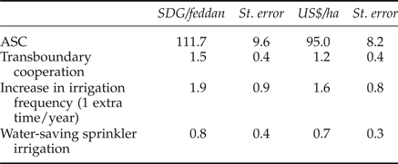
Finally, marginal willingness to pay (MWTP) values and standard errors for the non-monetary choice attributes were estimated using the Krinsky and Robb, Reference Krinsky and Robb1986 procedure (table 5). Over and above their current irrigation water fees, farmers are willing to pay, on average, US$1.6 per ha for every time they are allowed to flood their land extra, less than US$1 per ha to change from flood to more efficient sprinkler irrigation, and US$1.2 per ha for transboundary cooperation instead of improved local irrigation water governance to reduce siltation in the irrigation channels and hence increase water availability in times of water shortage. Compared to the average water fee farmers were reported to pay for the four main cash crops in the area (groundnuts, cotton, wheat and sorghum) of about US$48 per ha, this implies an extra charge of no more than 3.4 per cent for one extra time of flood irrigation. If, however, we also include the positive value for the ASC, the increase which farmers in the Gezira are willing to pay over and above their current water fee for improved irrigation water supply and use efficiency in a transboundary water governance context is over 200 per cent.
Estimated MWTP for increased irrigation water supply and water use efficiency

6. Conclusions
The main objective of this study was to examine farmer demand for improved irrigation water supply and use efficiency in one of the largest irrigation schemes worldwide. The application of CEs is steadily increasing in the field of irrigation water supply (e.g., Rigby et al., Reference Rigby, Alcon and Burton2010). The novelty of the approach presented here is not so much found in the application of a CE to elicit demand for irrigation water supply in Sudan, but the introduction of a transboundary governance context to one of the major problems with irrigation water supply reliability downstream of the source of the Blue Nile. We find a positive disposition to and WTP for transboundary cooperation in order to solve the problem of irrigation channel siltation at the source.
New in our design is also the inclusion of both measures to increase water supply and water use efficiency through the introduction of new irrigation technology, in casu sprinkler instead of traditional gravity-based flood irrigation. The use of sprinkler irrigation depends crucially on the availability of sediment-free irrigation water and will only work if the siltation problem in the Gezira irrigation channels is solved at the same time.
As expected, choice behavior in the CE is significantly anchored upon the irrigation supply baseline conditions that each farmer faces in the Gezira irrigation scheme. Once we control for these baseline conditions and difference in land and water use efficiency across farmers, we are unable to find any additional impacts of the spatial distribution of farmers within the irrigation scheme, i.e., upstream or downstream of the scheme. Only farmers living in the western extension of the Gezira scheme appear to value irrigation water supply differently from the farmers living elsewhere throughout the scheme. Farmers living in the extension part, Managil, are not particularly more efficient in using water, but these farmers reported that they received relatively more irrigation water for wheat, which is grown by relatively more farmers in this part of the scheme.
Contrary to expectations, we are unable to find significant anchoring of choices on current water fees farmers pay for the cash crops they grow in the area. These current fees do not seem to be related to water use efficiency, scarcity costs or cost recovery of the operation and maintenance costs of the irrigation channels. More (or less) water use efficient farmers are also not significantly more (or less) interested in new irrigation technology, while education, age or farming experience also did not have any effect on the choices farmers made during the CE.
Despite the fact that we pre-tested the design and farmers were observed to have a clear understanding of the choice task at hand and carefully chose their preferred options during the CE, the results presented in this paper have to be interpreted with care for a number of reasons. First of all, the topic addressed in the survey of water shortage and improved irrigation water supply is a burning issue in the case study area. Although it was made clear that the policy alternatives were hypothetical, farmers may have hoped that the outcome of the survey would result in an immediate improvement of the current situation, and hence exhibited some degree of strategic behavior, e.g., by overstating the extent of the problem.
Secondly, although a majority of more than 70 per cent trusted that Ethiopian farmers upstream would indeed implement soil conservation measures if a transboundary cooperation were established, a quarter had doubts or were not sure. Hence, some degree of policy uncertainty and possible disbelief in the effectiveness of the transboundary collaboration may have played a role in the experiment too. However, there are no indications that the international solution was perceived by farmers as a higher risk–higher return strategy compared to the local solution, given the focus on improving water supply, not other ancillary benefits, and the high degree of trust and confidence in the presented policy alternatives. Farmers were debriefed at the end of the survey about their perceived credibility of the policy alternatives and only 3 per cent said that the policy alternatives were not credible, just as 3 per cent said that they did not believe that Ethiopian farmers would comply with the establishment of a transboundary cooperation between the two countries. One in five farmers (20 per cent) was convinced that the policy alternatives were very credible and 64 per cent said they thought they were somewhat credible.
Finally, although farmers seemed consistent in their choices and we were unable to find big differences in the error variance of choices made further down the choice sequence, we observed a change in their preference structure when going through the choice tasks, possibly due to preference learning. The implication of this finding is that choices made later on in the choice sequence are probably most reliable. However, excluding the first three or six choices from the database would have resulted in an unacceptably low number of observations, and it was therefore decided to present the aggregated model based on all choices.
Despite these caveats, we believe that the results presented here provide important indications of support for transboundary cooperation. Disbelief in the presented policy scenario often results in substantial protest behavior, which we did not observe in our case study. In fact, the number of times the opt-out was chosen was less than 1 per cent in all choice occasions. As prescribed in the early stated preference elicitation guidelines (e.g., Cummings et al., Reference Cummings, Brookshire and Schulze1986; Fischhoff and Furby, Reference Fischhoff and Furby1988), the reliable estimation of preferences and WTP requires a well-defined and well-understood institutional-economic context. We believe that the credibility of this context is of paramount importance, and deserves more investigation. Like Speelman et al., (Reference Speelman, Farolfi, Frija and Van Huylenbroeck2010) and Veettil et al., (Reference Veettil, Speelman, Frija, Buysse, Mondelaers and van Huylenbroeck2011), we demonstrate that choice behavior and associated WTP for improvements of irrigation water supply and use efficiency depend on the institutional context in which they are measured. Future work in this specific area of irrigation water pricing and valuation has to take this context into account.
Disclaimer
The results presented here are based on independent scientific research carried out by the authors of this manuscript following standard procedures in social scientific survey research. The survey employed in this study is available from the authors upon request. All respondents were first asked if they were willing to participate and hence participated on a voluntary basis. The response rate was 100 per cent. The authors are, as always, solely responsible for the content of this paper. Most importantly, the views expressed in this paper do not necessarily correspond with those of the Ministry of Irrigation and Water Resources or any other official organization responsible for the management of the Gezira irrigation scheme.