Introduction
Paddy fields account for approximately 15 per cent of the world’s arable land (Kuenzer & Knauer Reference Kuenzer and Knauer2013), sustaining more than one-third of the global population (Zhang et al. Reference Zhang2024) and playing a significant role in greenhouse gas emissions and water-resource management (Xiao et al. Reference Xiao2005; Dong & Xiao Reference Dong and Xiao2016). Although modern rice cultivation is centred on Asia’s major river deltas (Kuenzer & Knauer Reference Kuenzer and Knauer2013), archaeological paddy fields were concentrated primarily in China, South Korea and Japan. Those in South Korea and Japan date only as early as the Middle Mumun (c. 2850–2550 BP) (Ahn Reference Ahn2010) and Late Jomon (c. 2700–2300 BP) periods, respectively (Jin Reference Jin2006; Nasu & Momohara Reference Nasu and Momohara2016), while substantially earlier evidence is found in China, establishing it as the centre of paddy field origin (Fuller Reference Fuller2011). However, when definitive paddy fields were first established and how their structure evolved under the environmental and social changes in eastern China remain unclear.
Understanding the origin and evolution of paddy fields is fundamental to tracing the development, diversification and dispersal of rice agriculture (Zong et al. Reference Zong, Chen, Innes, Chen, Wang and Wang2007; Zheng et al. Reference Zheng, Sun, Qin, Li, Wu and Chen2009; Fuller Reference Fuller2011). Although ambiguous field-like features dated to c. 8400 cal BP are found at the Hanjing site (Qiu et al. Reference Qiu, Zhuang, Rao, Lin and Zhuang2022; Zhuang et al. Reference Zhuang, Wei, Zhuang, Zhang and Xu2023), the earliest definitive paddy fields identified so far were excavated in the Yangzi River region, dating to around 6000 cal BP at sites such as Chengtoushan and Chuodun (Cao et al. Reference Cao2006; Hu et al. Reference Hu2013), providing clear archaeological evidence of established rice agriculture at this time (Fuller et al. Reference Fuller, Harvey and Qin2007). Subsequently, rice agriculture and cultivation systems expanded to south-western (d’Alpoim Guedes Reference d’Alpoim Guedes2011; Dal Martello et al. Reference Dal Martello, Min, Stevens, Higham, Higham, Qin and Fuller2018; Huan et al. Reference Huan, Deng, Zhou, Yan, Hao, Bu and Lu2022) and southern China (Zhang & Hung Reference Zhang and Hung2010; Yang et al. Reference Yang2018) by c. 5000 cal BP. Upland rice then dispersed into mainland Southeast Asia around 4000 cal BP, via inland or coastal routes, originating from south-western, southern and/or south-eastern China (Higham Reference Higham, Bellwood and Renfrew2003; Castillo et al. Reference Castillo, Chang, Douka, Fuller, Higham, Higham and Miller2018; Dal Martello et al. Reference Dal Martello, Min, Stevens, Higham, Higham, Qin and Fuller2018; Gao et al. Reference Gao, Dong, Yang and Chen2020).
Beyond the origin and dispersal of rice agriculture, paddy-field evolution significantly influenced local social development (Qin & Fuller Reference Qin, Fuller, Wu and Rolett2019; Fuller Reference Fuller2020) and wider palaeoclimatic change (Fuller et al. Reference Fuller2011; Ruddiman et al. Reference Ruddiman2016). Intensified paddy systems demanded substantial labour and sophisticated water management, enabling sustained demographic growth that accelerated social complexity from 5800 cal BP (Rosen et al. Reference Rosen, Macphail, Liu, Chen and Weisskopf2017; Qin & Fuller Reference Qin, Fuller, Wu and Rolett2019) and promoting the emergence of the earliest hydraulic enterprise and state society of Liangzhu City in East Asia (Liu et al. Reference Liu2017; Renfrew & Liu Reference Renfrew and Liu2018). Concurrently, as major anthropogenic methane sources—contributing approximately 22 per cent of modern-day agricultural emissions (IPCC 2021)—paddy fields drove anomalous atmospheric methane increases after 5000 cal BP—a core tenet of the Early Anthropocene Hypothesis (Ruddiman Reference Ruddiman2003; Ruddiman et al. Reference Ruddiman, Guo, Zhou, Wu and Yu2008).
Since the initial discovery of the archaeological remains of paddy fields at the Caoxieshan site in 1992–1995 (Gu et al. Reference Gu, Zou, Li, Tang, Diing and Zou1998), extensive research has analysed the field structures, cultivation techniques and soil properties of ancient rice-agriculture systems, including multiproxy soil studies at the Chuodun site (Cao et al. Reference Cao2006; Yang et al. Reference Yang, Li, Jin, Wang, Cao, Dai and Ran2006; Li et al. Reference Li2007; Hu et al. Reference Hu2013) and geoarchaeological investigations of paddy fields across the prehistoric Yangzi Delta and Huai River regions (Zhuang et al. Reference Zhuang2025). However, definitive paddy fields are only currently observable from c. 6000 cal BP (Qin & Fuller Reference Qin, Fuller, Wu and Rolett2019) despite the initial exploitation and domestication of rice having been traced back to c. 24 000 and 11 000 cal BP, respectively (Zhang et al. Reference Zhang2024). Key issues regarding the coevolution of paddy fields with early agricultural societies therefore remain unresolved, constrained by insufficient high-resolution sediment records and limited large-scale excavations.
To address these lacunae, based on a recent excavation of paddy fields at the Shiao site in the Lower Yangzi River (Figure 1a), we employ robust Bayesian chronological modelling to investigate the initiation, evolution and abandonment of paddy fields during the Mid–Late Neolithic (7000–4000 cal BP). Correlation with the sedimentary sequence from the nearby Yushan site further seeks to contextualise regional-scale relationships between ancient paddy field evolution, sea-level fluctuations and hydrological changes, while the identification of diverse patterns of ancient paddy fields across eastern China deepens our understanding of subsistence responses to increasing population sizes and social complexity.
Location and terrain of the Shiao site: a) location of Shiao and related sites; b) topographical map of the Yaojiang Valley; c) aerial image of Shiao and Tianluoshan sites in September 2020 (figure by authors).

The Shiao site
The Shiao site (30°1′39″N, 121°22′31″E) is located on the border between Cuiping Hill and the Yuyaojiang Valley, on the edge of Yuyao City in south Hangzhou Bay, Zhejiang Province, eastern China (Figure 1a). It is situated 400m north-west of the Tianluoshan site (Figure 1b), where ancient paddy fields have also been uncovered. Drilling of sediment cores indicates that paddy fields covered an estimated 80 000m2 at the Shiao site (Figure 1a). Excavations were conducted between 2020 and 2021 by the Zhejiang Provincial Institute of Cultural Relics and Archaeology, Ningbo Institute of Cultural Heritage Management and Yuyao Hemudu Site Museum, unearthing approximately 10 000m2 of the site (Zhejiang Provincial Institute of Cultural Relics and Archaeology et al. 2023). The excavation was conducted using a combination of square units and trenches and revealed paddy fields composed of ridges, ditches and ditch outlets. Pottery typology and a series of radiocarbon dates indicate that these features are associated with three cultural periods: the early (c. 6700–6300 cal BP) and late Hemudu (c. 5600–5000 cal BP) and the Liangzhu (c. 4900–4500 cal BP), see below.
The sediment at the Shiao site can be divided into 13 layers with surface elevations ranging from 1.4–4.2m (the Yellow Sea datum). Upper layers 1–3 encompass modern and historic sediments and were removed using construction machinery before excavation. Lower layers 4–13 are divided into three categories in terms of soil texture, colour and embedded pottery sherds (Figure 2a). Layers 11, 8–7 and 6 are composed of dark grey and grey-brown silt and are identified as paddy fields belonging to the early and late Hemudu and Liangzhu culture periods, respectively; layers 12, 10 and 5 are dark black peat with rich humus and plant debris; and layers 13, 9 and 4 consist of blue-grey and greyish-yellow clay and are identified as marine sediment (Zhejiang Provincial Institute of Cultural Relics and Archaeology et al. 2023). Thus, two sedimentary sequences of paddy fields successively overlaid by peat and marine sediments are observed at the Shiao site: layers 11–9 (Figure 2c) and 6–4 (Figure 2b).
Stratigraphy at the Shiao site: a) typical sedimentary facies ranging from layers 13–4; b) rice paddy stratum from the Liangzhu culture; c) rice paddy stratum from the early Hemudu culture (figure by authors).

Bayesian chronological modelling
Thirty samples of organic material were collected for dating during the archaeological excavation, primarily consisting of annual seeds. These were submitted to Beta Analytic, Miami, for processing and detailed information on the resultant dates is provided in the online supplementary material (OSM Table S1). Bayesian modelling of the radiocarbon dates was conducted using OxCal 4.4 (Bronk Ramsey Reference Bronk Ramsey2009), and dates were calibrated using the IntCal 20 atmospheric calibration curve (Reimer et al. Reference Reimer2020) (Figure 3). The basic building blocks of the models are the OxCal command terms Sequence and Phase, which define an ordered and unordered group of events/parameters, respectively. Prior information on stratigraphic layers was used to inform the Bayesian models. Thus, models composed of eight Sequence and one Phase were applied to restrict the temporal ranges of individual dates and events, and to define the chronological range of each layer.
Results of Bayesian chronological modelling for the Shiao site. Sequences L11, L8/L7 and L6 belong to paddy fields of the early and late Hemudu culture and Liangzhu culture periods, respectively (figure by authors).

The models indicate that the earliest paddy fields of layer 11 were formed from c. 6700–6300 cal BP, corresponding to the early Hemudu culture. Subsequently, the paddy fields of layers 8–7 and 6 formed from c. 5600–5000 cal BP and c. 4900–4500 cal BP, respectively (Figure 3, in red). The peat (layer 10) and marine sediments (layer 9) overlying the paddy fields of the early Hemudu culture range in date from c. 6400–6200 and c. 6200–5600 cal BP, respectively. The peat (layer 5) overlying the paddy fields of the late Hemudu and Liangzhu cultures ranges from c. 4500–4100 cal BP in date. The chronological range of the marine sediment of layer 4 (c. 4100–3600 cal BP) is inferred from the dating of layers 5 and 3, as layer 4 lacks suitable materials for radiocarbon dating.
Archaeological paddy fields at Shiao
The early Hemudu culture
The paddy fields of the early Hemudu culture, ranging from c. 6700–6300 cal BP, were unearthed in the south-west of the excavation area (Figure 4a). The paddy fields deposit is approximately 0.2m thick and is relatively level with only slight fluctuations (Figure 4b). One paddy ridge (L38) was identified during the excavation, trending north-west to south-east, measuring approximately 5.2m long and 2.2m wide, and paved with dark-grey paddy soil (Figure 4c) (Zhejiang Provincial Institute of Cultural Relics and Archaeology et al. 2023).
Paddy field from the early Hemudu culture period; a) location of the paddy field within the excavated area; b) aerial photograph of the paddy field; c) detail of the only ridge excavated from the early Hemudu culture (figure by authors; image 4b modified from Zhejiang Provincial Institute of Cultural Relics and Archaeology et al. 2023: fig. 6).

The late Hemudu culture
The paddy fields of the late Hemudu culture, ranging from c. 5600–5000 cal BP, are composed of a complete field ridge and an irrigation-drainage system but no completely enclosed paddy fields were unearthed. Nine east–west ridges were found, mainly in the middle flat area, and three north–south ridges were found on both sides of the mountain front (Figure 5a). The east–west ridges, such as L2, are narrow (0.3–1.3m) and composed of black-grey paddy soil (Figure 5c), while the north–south ridges are wider (1–3 m) and consist of greyish-yellow silty clay, such as L36 (Figure 5d). Five ditch outlets were identified (Figure 5b), including K11 situated in the middle of ridge L36 (Figure 5e). Two associated ditches running north–south were also found: G4, approximately 2–8m in width, and G10, approximately 4–10m in width (Zhejiang Provincial Institute of Cultural Relics and Archaeology et al. 2023).
Paddy fields from the late Hemudu culture period; a) aerial photograph of the paddy fields; b) the ridges, ditches and ditch outlets composing the paddy fields in the western area; c & d) the east–west ridge L2 and north–south ridge L36; e) ditch outlet K11 in ditch L35 (figure by authors; images 5c and 5e modified from Zhejiang Provincial Institute of Cultural Relics and Archaeology et al. 2023: figs. 12 & 14).

The Liangzhu culture
The paddy fields of the Liangzhu culture, ranging from c. 4900–4500 cal BP, exhibit a ‘hash’-shaped (or jing 井) structure that is composed of raised crisscrossing ridges (Figure 6b). Thirteen east–west ridges and nine north–south ridges were found, all generally 1–4m wide and composed of black-grey paddy soil (Figure 6c). Some of the east–west ridges also had branches laid at their base (Figure 6d). Seven parcels of paddy fields were isolated by crisscrossing ridges with areas ranging from 230 (S5) to 1750m2 (S3) (Figure 6b). Ten ditch outlets were found at intervals ranging from 1 to 4m (Figure 6e). One north–south ditch (G9) was found in the western excavation area, with some stones laid at the bottom (Figure 6f) and wooden drainage facilities in the south (Figure 6g) (Zhejiang Provincial Institute of Cultural Relics and Archaeology et al. 2023).
Paddy fields from the Liangzhu culture; a) location of the paddy field in the excavation area; b) the crisscrossing ridges, rectangular fields, ditch and ditch outlets composing the paddy fields; c, d) the T-shaped ridge L11-L14 and excavation of east–west ridge L12, revealing branches laid at the bottom; e) ditch outlet K5 in ridge L12; f, g) excavation of ditch G9 revealing stones laid at the bottom in the middle and wooden drainage facilities to the south (figure by authors; images 6c–g modified from Zhejiang Provincial Institute of Cultural Relics and Archaeology et al. 2023: figs. 19, 18, 22, 20 & 23).

Archaeobotanical records
Over 200 sediment samples underwent flotation and phytolith extraction, with detailed archaeobotanical analysis ongoing. Macro and microremains from paddy fields of all three periods primarily consist of rice (Oryza sativa) spikelets, husks and grains; seeds of pondweed (Potamogetonaceae) and reeds/sedges (Eleocharis sp. and Scirpus sp.); and bulliform phytoliths from rice and perennial reeds (Phragmites) and grasses (Miscanthus) (Figure S1). In contrast, peat and marine sediments yielded predominantly Scirpus sp. seeds. Further research is required to refine the identification of rice spikelet bases, bulliform phytoliths and diatom assemblages.
Discussion
Two sedimentary sequences of paddy fields in the Ningshao Plain
The evolution of paddy fields at the Shiao site can be divided into two discontinuous stages: the early Hemudu culture (layer 11, c. 6700–6300 cal BP; Figure 2c) and the late Hemudu to Liangzhu culture (layers 8–6, c. 5600–4500 cal BP; Figure 2b), both of which were overlaid by peat and marine sediments. Bottom-up sedimentary sequences of paddy, peat and marine facies have also been discovered at the nearby Tianluoshan (Zheng et al. Reference Zheng, Sun and Chen2011) and Yushan sites (He et al. Reference He2018) (Figure 1a). In particular, the peat and marine sediments of the Shiao site were dominated by seeds of Scirpus sp., such as S. mariqueter and S. triqueter, indicating a lower salt marsh environment that was frequently affected by ocean tides (Tang & Lu Reference Tang and Lu2003). In contrast, the predominant seeds and phytoliths in paddy fields comprised rice and reed, implying a freshwater wetland in the supratidal zone. Detailed microfossil analysis at the Yushan site (Figure 7) suggests that the paddy fields were reclaimed from freshwater and slightly brackish coastal wetlands, as indicated by the dominance of freshwater diatoms and aquatic pollen (He et al. Reference He2018). Subsequently, the gradual rise in marine diatoms and a peak of brackish diatoms suggest the formation of peat induced by the elevated groundwater table in response to the relative sea-level rise. Finally, as the relative sea level increased further, the rapid rise in marine diatoms and decline in brackish and freshwater diatoms indicate the complete submergence of the paddy fields. Similar records are found at Tianluoshan (Zheng et al. Reference Zheng, Sun and Chen2011) and Kuahuqiao (Innes et al. Reference Innes, Zong, Chen, Chen, Wang and Wang2009), thus brackish peat may serve as an indicator of possible underlying paddy fields in the Ningshao Plain.
Sedimentary facies and microfossil assemblage at the Yushan site. The grey overlay indicates the layers of paddy fields. The dashed orange line denotes the identifying criterion for paddy fields of 5000 grains/g of rice bulliform phytoliths (Fujiwara & Sugiyama Reference Fujiwara and Sugiyama1985). Detailed information on the microfossil assemblage has been published elsewhere (He et al. Reference He2018) (figure by authors).

Most paddy fields in the Ningshao Plain seem to have been formed directly above marine sediments, though this is not the case for the paddy fields of the early Hemudu culture at the Shiao site, which formed above peat. The peat below the paddy fields may indicate a buried humus gley horizon (DAG) of paddy soils originating from boggy soil (Gong Reference Gong and Stewart1986), which may have been thoroughly transformed into paddy in the later period. Paddy fields of the Liangzhu culture seem to have been abandoned earlier at Yushan (c. 5100 cal BP) than at Shiao (c. 4500 cal BP) and Tianluoshan (c. 4600 cal BP). The different timing could result from dating errors, but it is possible that proximity to the coastline was also an important factor; the Yushan site is situated approximately 17km east of the Shiao site and is thus nearer the coast and may have been inundated sooner as the relative sea level rose. In addition, the marine sediments overlying the paddy fields of the Liangzhu culture are generally greyish-yellow clay silts that are often equated with the collapse of the Liangzhu culture (Wang et al. Reference Wang2018; He et al. Reference He2021).
Evolution of paddy fields and social complexity in eastern China
To date, about 17 Neolithic paddy fields have been excavated in China, covering the Huai River Valley, the Haidai region and the Middle and Lower Yangzi River Valley (Figure 8a, Table S2). Essential elements by which paddy fields may be identified have been proposed—including ridges, irrigation ditches, ditch outlets and irrigation tools (Greenland Reference Greenland1997; Cao Reference Cao2008)—but the structures of ancient paddy fields excavated in eastern China vary in time and space (Guo & Guo Reference Guo and Guo2016; Liu Reference Liu2021), following four patterns in conjunction with the growth of human populations and social complexity (Figure 9).
a) Distribution of ancient paddy fields in eastern China: 1. Zhangwangzhuang; 2. Hanjing; 3. Zhaojiazhuang; 4. Taitou; 5. Tenghualuo; 6. Bashidang; 7. Chengtoushan; 8. Jijiaocheng; 9. Caoxieshan; 10. Chuodun; 11. Zhumucun; 12. Jiangli; 13. Chenghu; 14. Guangfulin; 15. Maoshan; 16. Tianluoshan; 17. Shiao (this study) (detailed information on these sites is provided in Table S2); b, g) paddy fields of the late and middle Liangzhu culture, respectively, at the Maoshan site (Zhuang et al. Reference Zhuang, Ding and French2014: fig. 2); c) paddy fields of the Shunshanji culture at the Hanjing site (Qiu et al. Reference Qiu, Zhuang, Rao, Lin and Zhuang2022); d) paddy fields of the late Majibang culture at the Chuodun site (Hu et al. Reference Hu2013: fig. 3); e) paddy fields of the late Majibang culture at the Caoxieshan site (Weisskopf et al. Reference Weisskopf, Qin, Ding, Ding, Sun and Fuller2015: fig. 4); f) paddy fields of the Tangjiagang culture at the Chengtoushan site (Hunan Provincial Institute of Archaeology and Cultural Relics 2007: colour pl. 18); h) paddy fields of the Longshan culture at the Zhaojiazhuang site (Jin et al. Reference Jin, Yan, Udatsu, Lan, Wang and Tong2007: fig. 4) (figure by authors).

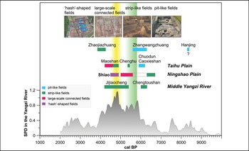
Paddy field evolution versus demographic patterns in eastern China. Demographic trends are reconstructed through summed probability distributions (SPD) of radiocarbon dates from the Middle and Lower Yangzi River (He et al. Reference He2022). The vertical green bar denotes the emergence of social hierarchy in the Songze culture, while the vertical yellow bar denotes the emergence of the earliest state society of Liangzhu (figure by authors).

Pattern 1: small pit-like fields with variable rectangular or irregular shapes. Early paddy fields in the Taihu Plain (Figure 8a, inset), from the late Majiabang culture (c. 6200–5800 cal BP), have small pit-like fields ranging in size from 1–15m2, such as at Chuodun and Caoxieshan (Figure 8d & e) (Hu et al. Reference Hu2013; Weisskopf et al. Reference Weisskopf, Qin, Ding, Ding, Sun and Fuller2015). Rice-field-like structures dating c. 8300 cal BP at Hanjing on the Huai River also seem to follow this pattern (Figure 8c) (Qiu et al. Reference Qiu, Zhuang, Rao, Lin and Zhuang2022). No artificial ridges were constructed so further verification of whether these were in fact paddy fields is needed. With low labour requirements and tight water-level control for pre-domestication cultivation (Fuller Reference Fuller2011), these pit-like fields could sustain only sparse populations during the Majiabang culture (Figure 9) (Chen & Zheng Reference Chen, Zheng and Chen2025).
Pattern 2: median strip-like fields separated by artificial ridges. The paddy fields in the Taihu Plain evolved into strip-like fields reaching tens of square metres from the Songze to the middle Liangzhu cultures (c. 5800–4600 cal BP), such as at Chenghu and Maoshan (Figure 8g) (Ding Reference Ding2004; Zhuang et al. Reference Zhuang, Ding and French2014). In contrast, the paddy fields in the Middle Yangzi, Ningshao and Haidai regions began with strip-like fields, for example at Chengtoushan (Figure 8f), Shiao (Figure 4b) and Zhaojiazhuang (Figure 8h) (Jin et al. Reference Jin, Yan, Udatsu, Lan, Wang and Tong2007; Fuller & Qin Reference Fuller and Qin2009). Expanded paddy units demanded increased labour investment for intensive rice cultivation (Fuller & Qin Reference Fuller and Qin2009), which supported rapid demographic expansion (Figure 9) and reinforced social stratification in the Songze culture c. 5800 cal BP (Li Reference Li2012).
Pattern 3: large-scale connected fields separated by ridges up to 100m in length. The paddy fields at Maoshan (Figure 8b) (Zheng et al. Reference Zheng, Chen and Ding2014; Zhuang et al. Reference Zhuang, Ding and French2014) in the Taihu Plain and at Shiao (Figure 5a) in the Ningshao Plain evolved into large-scale connected paddies, reaching hundreds of square metres during the late Liangzhu (c. 4600–4300 cal BP) and late Hemudu cultures (c. 5600–5000 cal BP), respectively. Designed for efficiency with definitive road and irrigation systems, these expansive paddies sustained sizable populations whose labour built the Liangzhu hydraulic enterprise (Liu et al. Reference Liu2017). Peak population density at c. 4800 cal BP (Figure 9) coincided with the rise of Liangzhu as East Asia’s earliest state society (Renfrew & Liu Reference Renfrew and Liu2018).
Pattern 4: ‘hash’-shaped fields enclosed by criss-crossing ridges. Only one case of ‘hash’-shaped fields has been found in China so far, that of the Shiao site during the Liangzhu culture (Figure 6b). Each field, ranging from hundreds to thousands of square metres, was completely enclosed by raised ridges. The ‘hash’-shaped field may represent a regional variant of the large-scale connected fields that underlay Liangzhu cultural prosperity. Given the c. 5000 cal BP marine transgression at Yushan (He et al. Reference He2018), the criss-crossing ridges at Shiao were likely engineered to mitigate seawater intrusion across the Ningshao coastal plain (Zheng et al. Reference Zheng, Sun and Chen2011).
Overall, with the exception of the dubious small pit-like fields, the structures of the ancient paddy fields found at Shiao follow the evolutionary pathway from median strip-like fields through large-scale connected fields to ‘hash’-shaped fields with the area increasing from tens to hundreds to thousands of square metres. The evolution and expansion of paddy fields intensified water management and labour inputs (Fuller & Qin Reference Fuller and Qin2009; Zhuang et al. Reference Zhuang2025), driving local populations towards increasing density and social complexity (Figure 9) and ultimately stimulating the emergence of state society (Qin & Fuller Reference Qin, Fuller, Wu and Rolett2019). Nevertheless, the evolutionary pathway varied across different regions, and not all patterns of fields are always in evidence. The paddy fields in the Taihu Plain began as small pit-like fields during the late Majiabang culture (Chuodun, Caoxieshan) and ended as large-scale connected fields during the late Liangzhu culture (Maoshan) (Figure 9), which seems to appear later than those in the contemporaneous Ningshao Plain.
Conclusion
Sediments and associated ridges dating back to the early Hemudu culture, c. 6700 cal BP, at the Shiao site in the Ningshao Plain of the Lower Yangzi River Valley constitute the earliest yet identified definitive paddy fields in eastern China. Paddy fields from three cultural periods were found, including strip-like fields of the early Hemudu culture (c. 6700–6300 cal BP), large-scale connected fields of the late Hemudu culture (c. 5600–5000 cal BP) and ‘hash’-shaped fields of the Liangzhu culture (c. 4900–4500 cal BP). Two bottom-up sedimentary sequences of paddy, peat and marine facies suggest a repeated sequence of transition from coastal wetlands to marine submergence and back again in response to relative sea-level changes. Within the broader context of eastern China, these findings suggest that the coevolution of paddy systems and early agricultural societies varied across time and space but followed a general evolutionary pathway from median strip-like fields to large-scale connected and ‘hash’-shaped fields, stimulating trends towards social complexity and the emergence of state society.
Acknowledgements
We are grateful to all the team members who participated in the Shiao excavations in 2020 and 2021. We would like to thank the English-language editing and proofreading services of Editage. We thank the anonymous reviewers for their helpful comments.
Funding statement
This research was supported by the National Natural Science Foundation of China (nos. 42477479, T2192954 and 41902187), Open Research Fund of the Center for Archaeological Science, Sichuan University (no. 24SASB06), Innovative Research Project of Sichuan University (no. 2023CX11) and Fundamental Research Funds for Central Universities.
Online supplementary material (OSM)
To view supplementary material for this article, please visit https://doi.org/10.15184/aqy.2025.10268 and select the supplementary materials tab.
Author contributions: CRediT Taxonomy
Yonglei Wang: Conceptualization-Lead, Project administration-Lead, Writing - review & editing-Supporting. Keyang He: Conceptualization-Equal, Writing - original draft-Lead, Writing - review & editing-Lead. Shu Song: Investigation-Supporting. Yixin Zhang: Investigation-Supporting. Shuwen Mei: Investigation-Supporting. Xuejiao Lu: Investigation-Supporting. Yunfei Zheng: Conceptualization-Equal, Project administration-Equal. Guoping Sun: Conceptualization-Equal, Project administration-Lead. Houyuan Lu: Conceptualization-Equal, Writing - review & editing-Equal.