As much of the evidence for the Roman presence in Scotland consists of forts and camps, it is no surprise that the majority of research has centred on the military campaigns of the first and second centuries.Footnote 1 In this paradigm, the impact of Rome on Scotland seems minimal, aggressive and ultimately a failure.Footnote 2 Recent views on the Roman legacy in Scotland have moved away from the short-lived military monuments to the various entanglements with empire over the long term.Footnote 3 This is part of a wider programme of research on the Roman armies in Britain which emphasises the complexities of military and civilian interaction through close studies of material culture and landscape.Footnote 4 Rather than seeing the Roman period in Scotland as a series of short interludes, it is clear from the continued presence and circulation of Roman material culture that warfare was only one facet of the northern experience of empire.Footnote 5 The image of Scotland as ‘beyond the edge of empire’ is not only inaccurate, it has been an obstacle to a fuller understanding of the role of the North in the wider narrative of the Roman period in Britain.Footnote 6 The implications of this line of argument are that the emergence of Christianity and Latin literacy in southern Scotland from the fifth century must be seen in terms of indigenous agency and shared cultural outlook across the militarised North and West rather than later foreign importation.Footnote 7 It forces us to take a new look at local responses and engagements with the Roman world and how these were transformed in the post-imperial period.
The physical remains of Roman monuments are now increasingly dealt with in the context of their social and cultural landscape, in order to avoid limiting analysis to military and political concerns.Footnote 8 Recent scholarship on Hadrian's Wall epitomises this approach. Anthropological studies of social memory and materiality have prompted greater interest in the various ways the Wall itself was remembered (and forgotten) in the post-Roman period.Footnote 9 A key aspect of this process has been a biographical or ‘genealogical’ approach to the Wall, tracing the ways it has been experienced and understood by locals, visitors and scholars from the Roman period to the present day.Footnote 10 It has become clear that many of the Wall forts and vicus settlements were not simply abandoned after a.d. 410, but continued in use as power centres, for example the great timber hall built within the fort at Birdoswald,Footnote 11 or as religious sites, as attested by the Christian inscribed stones from Maryport and Vindolanda.Footnote 12 Further, the identification of the Wall solely as a ‘Roman’ monument denies the continued significance of the material presence of the past in the intervening centuries.Footnote 13 In studying the evolving remembrance and selective forgetting of these sites, the ancient Roman frontier has emerged not simply as a militarily contested space in the deep past, but a continuing social battleground in which the modern national identities of England, Scotland and Great Britain themselves have been forged.Footnote 14
In light of these studies of Hadrian's Wall, our perspective on the Antonine Wall must also be renewed, recognising that it has been a post-Roman monument longer than it was ever a ‘Roman’ one.Footnote 15 Indeed, as we will see below, for those communities who lived around the monument, its Roman history was often forgotten as more relevant narratives took its place. In a sense, the Antonine Wall has only resumed being ‘Roman’ in the last few centuries.Footnote 16 Understanding Roman archaeology in Scotland is no longer limited to troop numbers and defensive tactics, but is bound up in the materiality of the military landscape and shifting memories sedimenting upon the monuments left behind. This paper will assess the evidence for the changing reception and experience of the Antonine Wall in the post-Roman period to spark new research on the complicated legacy of Rome in the North.
THE REMNANTS OF ROME IN EARLY MEDIEVAL SCOTLAND
Discussions of Scotland during the Roman period use terms such as Roman Iron Age or simply later Iron Age, acknowledging broad continuities in indigenous social structures.Footnote 17 However, a strong indication that parts of Scotland were deeply entangled with the political and economic structures of the Empire is the transformation apparent in the archaeological record of the fifth century. The changes caused by the departure of the Roman armies in c. a.d. 410 are apparent on both sides of Hadrian's Wall, and from this point the archaeology of southern Scotland is characterised by large inhumation cemeteries, the earliest Latin-inscribed stones and the importation of exotic goods from the Mediterranean.Footnote 18 Place-name and historical evidence identifies these as Britons, often described as ‘Romanised’ to differentiate them from the Pictish and Gaelic-speaking peoples to north and west. However, these changes cannot solely be explained through a hazily defined, unilateral ‘Roman influence’ ending at the relict Antonine Wall, but instead reveal complicated networks of social interaction across northern and western Britain and Ireland with roots in the later Roman period.Footnote 19
The early medieval period is still most often discussed in ethnic terms in Scotland, although over the last decade overviews have begun to deconstruct the bounded realms of Picts, Scots, Britons and Anglo-Saxons.Footnote 20 While there are many archaeologically attested differences between these broad groups, one aspect among many they shared was an active engagement with ancient monuments. To mediate the tensions involved in creating a new power structure out of existing social norms, aspiring early medieval élites often made use of the ancient past to situate themselves within the wider cosmological order.Footnote 21 The Picts and Scots seem to have been particularly drawn to relics of the ancient past; it has been noted that their burials, especially the distinctive square barrows, were often situated alongside prehistoric monuments, while many of the Pictish symbol stones reused existing megaliths.Footnote 22 Less attention has been paid to the northern Britons’ attitudes to ancient monuments, despite evidence for creative engagements with the material culture of the past in this region, including burial in prehistoric landscapes, the erection of inscribed standing stones and the hoarding and reworking of Roman silver.Footnote 23
The reuse of Roman sites across Scotland is also under-studied. By and large, excavations on Roman forts have shown little certain evidence for later reuse. Despite being prominent landmarks, only some forts were permanently reoccupied in the following centuries; notable exceptions include later medieval churches at Ardoch (PER), Carriden (WLO) and Cramond (MLO), the post-Roman occupation at the latter being attested by Anglo-Saxon finds.Footnote 24 Post-Roman barrows reusing Roman masonry have been found over and adjacent to the legionary fortress at Inchtuthil (PER), while early medieval burials have also been discovered within the second-century fortlet of Burnswark (DMF) and the temporary camp of Little Kerse, Polmont (STL) (discussed below).Footnote 25 Even when they were not reoccupied, forts remained important landmarks, often appearing in the sparse historical record; for instance, a cross slab at Carpow (PER) marked the extent of the territory of the early monastery of Abernethy (PER).Footnote 26
A more frequent type of reuse was the quarrying of Roman sites for dressed and sculptured masonry. When this occurs at contemporary sites near to Roman structures, it is often considered pragmatic; examples include the souterrains at Shirva (DNB) (discussed below), Crichton (MLO) and Newstead (ROX),Footnote 27 and hillforts such as Rubers Law (ROX) and Inchtuthil (PER).Footnote 28 However, the majority of reused Roman masonry actually comes from the early medieval period. Puzzlingly, this indicates that many forts were searched for building material but were otherwise left unoccupied; for instance, stones from the upstanding fort of Lyne (PEB) were built into long cist graves in an adjacent hillock.Footnote 29 The early medieval long cist cemeteries of Thornybank (MLO) and Parkburn, Lasswade (MLO) both include graves built with Roman masonry, in each case brought from over 2 km away.Footnote 30 Roman masonry in the hillfort of Clatchard Craig (FIF) was sourced from the fort at Carpow 3 km to the west, while that from Dundurn (PER) could only have come from Strageath (PER), 7 km east of the hillfort.Footnote 31 Other examples show that this reused masonry could accrue special importance over time. Close study of the tooling on the Stone of Destiny, made of Perthshire sandstone local to Scone (PER), has shown that it may have originated as a piece of Roman masonry, possibly from the fort of Bertha just across the Tay.Footnote 32 The Anglian foundations of the seventh/eighth-century church at Hoddom (DMF) and a contemporary stone-built tanning shed both made considerable use of dressed and inscribed Roman stones from the fort of Birrens, 6 km to the north-east.Footnote 33 Roman altars built into the walls of Jedburgh Abbey (ROX), which lies 5 km west of Dere Street, may also derive from the earlier Anglian monastery there; Hoddom and Jedburgh thus fall into the wider pattern of Roman masonry reused in the earliest Northumbrian stone-built churches such as Hexham.Footnote 34
So far, it seems that the reuse of Roman sites and material culture in the early medieval period was not merely pragmatic and may have had a ritualised element to it, strongly associated first with hoarding and votive deposition and later with burial and stone-built churches. Whether or not these places and objects were remembered as being specifically Roman, they may have been selected for a perceived temporal liminality or cultural otherness, making them suitable nodes for practices which were meant to forge new identities in the medieval period.Footnote 35 When read in the context of other instances of early medieval reuse of ancient monuments in Scotland, these appear to be highly charged social statements loaded with meanings which we are only beginning to uncover.
THE EARLY ANTONINE WALL
Central to any discussion of Roman Scotland is its most prominent legacy, the complex line of monuments now collectively known as the Antonine Wall.Footnote 36 Begun in a.d. 142, it was built under the orders of the emperor Antoninus Pius (a.d. 138–61), arguably to show that he was a military leader worthy of his titles. It consisted of a wall of turf fronted by a massive ditch (the vallum) and outer bank (also referred to as the Outer Mound), garrisoned with forts built at regular intervals, and stretching from the Firth of Clyde at Old Kilpatrick (DNB) to the Firth of Forth at Carriden (WLO). Until relatively recently, higher sea levels meant that the Firth of Forth reached much further inland than it does today, potentially as far as Inveravon (WLO) or Camelon (STL); thus while the Wall crosses some of Scotland's most fertile river valleys, it is bracketed to north and south by rocky uplands and mossy carselands.Footnote 37 This narrow isthmus represents the shortest overland distance between the Forth and Clyde estuaries and the Roman road servicing these forts, known as the Military Way, facilitated movement to east and west.
Perhaps due to an increasing need for troops elsewhere in the Empire, by a.d. 158, the abandonment of the Antonine Wall had begun and would be completed within a decade. The fort buildings were carefully demolished and the army fell back to the newly refurbished Hadrian's Wall. But the 63-km barrier of the Antonine Wall was never fully slighted and even remains visible for some of its length today. Evidence for continuing interaction with the forts in the immediate post-Roman period can be seen at a handful of sites as discussed below. For future inhabitants of the Forth-Clyde isthmus, the Wall was and remains a prominent part of their everyday world.Footnote 38
THE CENTRAL BELT IN THE EARLY HISTORY OF SCOTLAND
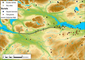
The Forth-Clyde corridor has long provided a conceptual boundary within Scotland and perennially forms the limit of distributions of certain classes of archaeological monument in the early medieval period. For instance, early Latin-inscribed stones only occur south of it, while Pictish symbol-incised stones occur mainly to the north;Footnote 39 as shown in fig. 1, it also forms the southern limit of the square barrow graves so characteristic of ‘Pictish’ Scotland.Footnote 40 This has led to a long-lived perception of the Antonine Wall, rather than Hadrian's Wall, as the boundary between the ‘Romanised’ Britons and barbaricum.Footnote 41 Indeed, some scholars have argued for a unique northern British culture which existed between the two Roman walls, manifested in the use of Latin epigraphy and the massive silver chains which have been found primarily in the intervallum area.Footnote 42 This tends to reify the Forth-Clyde line as an impermeable barrier, whereas recent work on the northern Britons has begun to take a broader remit, extending analysis beyond the Hadrianic and Antonine frontiers.Footnote 43
Map of the Antonine Wall and key sites mentioned in the text in the context of early medieval burial and ecclesiastical sites. 1. Dumbarton Rock; 2. Mountblow Cross; 3. Kirkintilloch Old Aisle; 4. Shirva; 5. Carrickstone; 6. Arthur's O'on; 7. Callendar Park; 8. Mumrills; 9. Little Kerse; 10. Old Kinneil Kirk; 11. Abercorn. (colour online)

There is, however, no doubt that this was a contested landscape and the upper reaches of the Forth estuary seem to have remained sword-land down to the eighth century, when the centre of an early medieval diocese fluctuated between the monasteries of Abercorn (WLO) and Culross (FIF) on either side of the firth.Footnote 44 Tellingly, the twelfth-century Life of St Serf has the founding saint hurling his crosier from Kinneil (WLO) to Culross as a device to explain the transference of the bishop's seat from Abercorn after c. a.d. 685.Footnote 45 The area remained a conceptual boundary even after it stopped functioning as a military frontier: down to the thirteenth century, the medieval kingdom of Scotia and its early medieval predecessor Alba only referred to lands north of the Forth; when lands south of the Forth-Clyde isthmus were annexed, these retained their ancient territorial identities of Lothian, Strathclyde, Galloway and Northumbria within the emerging kingdom of Scotland.Footnote 46
It is only when providing a political history of the landscape that the isthmus comes to look like an effective natural boundary. Yet this was not the case even in the second century: as with Hadrian's Wall, with its numerous gateways and associated road system, the Antonine Wall acted as a way to control and monitor movement across the isthmus rather than to stop it altogether.Footnote 47 Before and after the Roman period, historical and toponymic evidence suggests that the Iron Age tribes of the Votadini and Dumnonii, like their early medieval successor polities of Gododdin and Strathclyde, held lands on both sides of the isthmus, though it is perilous to back-project territorial extents from the insufficient documentary record.Footnote 48 Archaeologically, the area formed a boundary to some early medieval monument types as discussed earlier, but proved permeable to others: the long cist cemeteries and eccles- place-names so characteristic of this period extend from Lothian to Tayside (fig. 1).Footnote 49 Similarly, recent toponymic work has shown that ‘Pictish’ and ‘British’ place-name distributions are not bounded by the Forth-Clyde isthmus.Footnote 50 Contemporary sources are sparse, but reinforce an image of this area as being fought over by various peoples: Britons and Gaels at Strathcarron in a.d. 643; Picts and Anglo-Saxons in the Falkirk area in a.d. 711.Footnote 51 To take a more recent example of movement across this area, the Antonine Wall fort of Rough Castle was the location of Scotland's largest cattle market, the Trysts, for a short period in the late eighteenth century, as it formed a convenient meeting place for Highland and Lowland traders.Footnote 52 Much like the post-Roman Hadrian's Wall, most people may have only encountered the Wall by travelling through it rather than along it.Footnote 53
NAMING THE ANTONINE WALL
Unfortunately, we do not have any historical evidence from those who lived along the Wall to tell us how they experienced it. In fact, there are very few contemporary mentions of the Antonine Wall and by the fourth century even Roman writers could not remember who built it, many attributing it to Severus.Footnote 54 This muddled chronology was later integrated with the turbulent events of the post-Roman centuries in the highly polemical work De excidio Britanniae by Gildas (d. a.d. 570). In his version, the Wall was built by the post-Roman Britons to keep out marauding Picts and Scots,Footnote 55 a situation more reflective of events from Gildas’ lifetime than those of the second century. Gildas’ version of events was taken up by Bede (c. a.d. 673–735), writing from Jarrow and hence familiar with the stone-built Hadrian's Wall. In the eyes of both Gildas and Bede, the northern wall was inferior because it was built of turf and it was built in turf because it was built by Britons, unlike the Romans, who were remembered as building in stone.Footnote 56 Bede does, however, provide us with crucial information about the eighth-century setting of the Wall:
The clearest traces of the work constructed there, to wit a wall, most wide and most high, can be seen to this day. It starts almost two miles west of the monastery at Aebbercurnig in the place which is called in Pictish speech Peanfahel, and in the English tongue Penneltun; and stretching far westward, terminates beside urbs Alcluith.Footnote 57
The names Peanfahel and Penneltun survive as Kinneil, although given the distances provided by Bede, the ‘Pictish’ name may refer to a district rather than the modern village.Footnote 58 However, the form of the name is what is interesting here. The early form Peanfahel reveals a period where two languages mingled in this area: the indigenous Britonnic (or P-Celtic) language, represented by pen- meaning head or end, and Q-Celtic as seen in the second element, *fahel, representing the Gaelic pronunciation of a term ultimately deriving from the Latin vallum.Footnote 59Peanfahel is then a linguistic hybrid, roughly translating to the district at the ‘end of the wall’,Footnote 60 and is one of the few early place-names which directly refer to the Roman monument. Also important is Bede's description of its extent, using landmarks relevant to his audience: from urbs Alcluith (the hillfort of Dumbarton Rock) to the monastery of Aebbercurnig (Abercorn). Thus, by the eighth century, the Wall could still be remembered as originating in the ancient past, but was being described using fully native spatial referents.Footnote 61
The Historia Brittonum, a ninth-century compilation of historical sources on the origins of Britain, relies heavily on Bede's and Gildas’ accounts of the Wall, but correctly attributes it to the Romans instead of the Britons, though still incorrectly to Severus.Footnote 62 A twelfth-century manuscript copy adds that the local Britons referred to it as Guaul, and glosses Bede's Peanfahel with the Britonnic variant Penguaul.Footnote 63 Like the Gaelic *fahel, the P-Celtic element *guaul derives from the Latin vallum, the word for the Wall used by the Roman soldiers themselves on distance slabs.Footnote 64 The gradual transformation of ways of expressing ‘place at the end of the Wall’, incorporating elements from Latin, Britonnic, Gaelic and Old English, serves as a reminder of how this area was a meeting place of peoples and attests to a messy period of multilingualism instead of a linear narrative of succession from Britonnic to Gaelic.
There are some rather less certain toponymic references to the Wall to round these out. First, there is Carmuirs (STL) near Falkirk. Its first element is almost certainly caer for fort, which may refer to any of the numerous Roman temporary camps in the area (e.g. NMRS nos NS88SE 22, NS88SE 27), although it could equally refer to the undated multivallate enclosure at Wester Carmuirs (NS88SW 27). Its second element seems to be from *mur, a Britonnic loan-word from the Latin murus for wall.Footnote 65 Along with Guaul, this would be further evidence for a Latinate loan-word into Britonnic in this area. Further toponymic evidence of a vernacular word for the Wall is Cleddans (DNB), now attached to the Antonine fortlet east of Duntocher. This derives from Gaelic clad for a name meaning ‘at the ditch place’, which may feasibly refer to the Wall.Footnote 66 Other names referring to the Wall are of questionable antiquity, including those ending in the Scots element -dyke, most likely coined in the modern period.Footnote 67
In the absence of other primary sources, place-names represent a potential avenue for further research into early medieval settlement in the area. For instance, numerous names in caer- (P-Celtic for enclosure or fortification) are associated with Roman forts across Scotland and may reveal post-Roman recognition of these sites as a discrete monument type.Footnote 68 In the Forth-Clyde zone, many of these fort names survived as the names of settlement centres or parishes, as at Carriden (WLO), Castlecary (STL) and Kirkintilloch (DNB). The latter deserves further attention: its earliest recorded form is the twelfth-century Cair Pentaloch, revealing its derivation not from the Scots word kirk for church, but from the Britonnic caer. Interestingly, like Peanfahel, Pentaloch is a hybrid Britonnic and Gaelic name, its first element being the Brittonic pen and the second element from tulach, Gaelic for hillock or ridge.Footnote 69 The name thus translates roughly to ‘fort at the end of the low ridge’ and again attests to the Wall's place within a multilingual milieu at the time that these names were coined.Footnote 70
Thus earlier names for the Wall may be hidden by the later medieval prominence of Scots as the spoken language in this area. A good example of this is the evolution of the name Falkirk. It is first recorded as Egglesbreth, later Eaglais Bhreac, meaning ‘speckled church’.Footnote 71 This incorporates an early form of ecclesiastical place-name deriving from the Latin, eccles (see fig. 1), which in Scotland was used in P-Celtic contexts to denote a church of some standing in the early medieval period.Footnote 72 The second element is Q-Celtic, again making this a ‘hybrid’ name like Kirkintilloch and Kinneil. The thirteenth-century name Falkirk is actually a calque of ‘speckled church’ in Scots, making it the latest iteration of an evolving name in use for centuries.Footnote 73 It is worth noting that this progression from Britonnic to Gaelic to Scots did not occur everywhere in the Antonine Wall zone and Gaelic parish names including Kilpatrick and Cadder (LAN) remain in use toward the western terminus. The former contains the element kil for church; the latter is from cathair for fort or enclosure and may refer to the Roman fort.Footnote 74
The sources for the naming of the Wall then largely fall silent until the fourteenth century, when John of Fordun reports that the Wall was known locally as Grymisdyke, after a pseudo-historical British warlord Grim famous for breaking through it.Footnote 75 Recent work on the development of this legend from the thirteenth to the eighteenth century by Darrell Rohl highlights a number of intriguing potential origins and derivations of the name Grim or Graeme, but all the evidence points to a strong association with the eastern extent of the Wall in the high medieval period.Footnote 76 Despite the continuing memory of the Romans found in Bede, Gildas and the Historia Brittonum, by the end of the medieval period, the Wall had inspired its own local mythology.Footnote 77 William Camden was the first antiquarian to attribute the Wall to Antoninus Pius, but it was not until the seventeenth-century discovery of the Balmuildy inscription (naming the governor Lollius Urbicus), and subsequent finds of distance slabs through agricultural activity, canal-building and railway works, that the issue was settled.Footnote 78 Even then, the Wall remained known as Grim's Dyke or Graham's Dyke and it was not until the Glasgow Archaeological Society's 1899 Antonine Wall Report that the modern name came into common usage.Footnote 79
Many explanations have been offered to explain the Grim's Dyke name, but one rarely considered is the link with the numerous Grim's Dykes of Anglo-Saxon England.Footnote 80 Grim was variously used as a nickname for the Old Norse god Odin or the Devil, and the name was attached to any number of manmade earthworks and mounds whose origin was lost to memory, as reviewed most recently by Sarah Semple.Footnote 81 The practice of attributing ancient monuments to generic supernatural figures was common in the Anglo-Saxon period, when Roman stone structures were deemed ‘the work of giants’ and ancient monuments could be attributed to heroes, deities and supernatural creatures.Footnote 82 Notably, Semple demonstrates that the name Grim was particularly likely to be attached to linear ditches and earthworks.Footnote 83 Her study unfortunately does not extend north of the modern border, but there are several other examples of this phenomenon in southern Scotland, including prominent medieval earthworks such as the Deil's Dyke, Nithsdale (DMF),Footnote 84 and Grymisdyke may be fruitfully added to the corpus of Grim's Dyke names in Britain. Rather than any lingering belief in pagan gods such as Odin, such names indicate how monuments without a past could provoke awe and even fear; Semple also notes a marked increase in names related to the Devil, Hell and damnation from the tenth century onward, as ancient monuments were increasingly marginalised for use as open-air courts and gallows.Footnote 85 Given Rohl's identification of the roots of this legend and place-name in eastern parts of the Wall, a region historically under Northumbrian sway for much of the early medieval period,Footnote 86 there is a tantalising case to be made that the name was coined early on, but most likely after the eighth century as it does not enter Bede's description of the Wall. The medieval origin of the name Grymisdyke thus most likely lies in an Anglo-Saxon context and its later attribution to pseudo-historical figures by Fordun and Buchanan can be seen as learned interpolations meant to explain away what was by then seen as folk superstition. It also serves to remind us that even though the origins of ancient monuments could be quickly forgotten in the popular imagination, they could just as easily be ascribed new meanings by each successive generation.Footnote 87
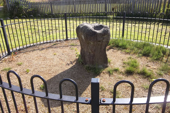
Perhaps the best examples of this are to be found in two Roman monuments found in the landscape beyond the Roman forts. The curious dome-shaped structure known as Arthur's O'on or Arthur's Oven at Stenhousemuir (STL) near the mouth of the river Carron was demolished in 1743, but it is likely that this was a Roman temple.Footnote 88 The story of this remarkable monument has recently been given new life by Rohl, who identifies numerous mentions of it by various names from the twelfth century onward, not least of which is the place-name Stenhousemuir, from Stanhus (1293) or ‘stone house’, likely Arthur's O'on itself.Footnote 89 Its first historical notices in the twelfth century deem it a hall or palace of King Arthur, but a competing early tradition attributed it to the Roman period either as a shrine, temple or victory monument, the latter now regarded as the likeliest interpretation.Footnote 90 Yet the name links it with Arthurian legend, again showing how those interacting with the monument on a daily basis ascribed their own myths and meanings despite it being recognised by others as a Roman monument. The Carrickstone (DNB) (fig. 2) presents a similar case: this is a Roman altar which has survived in an open-air context since antiquity (judging by its severely eroded state). Its Latin inscription (now illegible) and form would have identified it as a Roman monument to a learned observer, but it has clearly been put to other uses over time and, at least since the nineteenth century, it was linked to King Robert the Bruce.Footnote 91 Less implausibly, it was also said to be a resting place for funeral processions on the way across the large former parish of Kirkintilloch, before the creation of Cumbernauld parish from its eastern extent in 1659.Footnote 92
The Carrickstone near Cumbernauld, DNB, a Roman altar barely recognisable after centuries in the open air. (Photo: author) (colour online)

The historical and toponymic evidence thus provides a window on the way the Roman frontier was conceptualised in the early medieval period. The naming and renaming of sites along the Antonine Wall and the Wall itself indicate changing strategies of ownership and control, as well as a complex history of emotional responses such as fear and dread, emanating from and accruing upon the physicality of its remains. For another perspective, we can turn to the archaeological evidence.
REUSE OF ROMAN MONUMENTS
Given the evidence for post-Roman occupation at numerous Hadrian's Wall forts,Footnote 93 it is striking how few of the Antonine Wall forts show clear evidence of reuse. However, there is a distinct difference between the two frontiers as the forts on Hadrian's Wall formed the basis for civilian settlement during and to a certain extent after the fifth century,Footnote 94 while evidence for contemporary settlement in the Antonine Wall zone remains exiguous. Early medieval settlement evidence is severely lacking across Scotland, but in the Antonine Wall zone there is a good argument that it is largely being obscured by medieval and modern settlement. For instance, the Roman forts at Falkirk, Kirkintilloch and Old Kilpatrick are now obscured by development and are glimpsed only through keyhole excavations and stray finds.Footnote 95 In these situations, ‘reuse’ is difficult to quantify; even when there is direct superimposition of medieval structures upon Roman fortifications, deliberate reoccupation cannot always be assumed, since later settlement may have been drawn to the strategic locations of many Roman forts rather than any conscious claim on an ancient monument. In these cases, all that can be done is to assess the antiquity of the settlement evidence overlying the fort and flag it up as an avenue for further research.
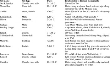
As shown in Table 1, there are a good number of sites where medieval power centres occur at or near the Roman monuments of the Antonine Wall. Only the motte at Kirkintilloch seems to deliberately reoccupy a Roman fort, but like the mottes at Watling Lodge (STL) and Seabegs (STL), this uses the Wall ditch as part of its defensive enclosure; the motte at Cadder is adjacent to but not abutting the Wall.Footnote 96 However, none of these sites need be earlier than the twelfth century and thus they relate to a later medieval paradigm of military feudal control over land and people.Footnote 97 The late medieval tower house at Inveravon is not earlier than the fifteenth century, though its location hard by the Wall indicates the strategic value of the Roman fort's location.Footnote 98
MEDIEVAL SETTLEMENT ON ROMAN SITES ALONG THE ANTONINE WALL, FROM WEST TO EAST

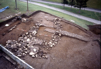
The best archaeological evidence for the early medieval reuse of the Wall line as a power centre comes from Callendar Park in Falkirk (STL), where the Wall is still clearly visible today. Excavations along the line of the Military Way in 1989–90 unexpectedly discovered an apse-ended timber structure with stone footings (fig. 3); charcoal from one of the large post-holes returned a radiocarbon date centring on the ninth century a.d.Footnote 99 There are documented thanes of Callendar, which still retained the P-Celtic name Calatria, in the twelfth and thirteenth centuries; the thanage is a continuing form of lordship dating back to the early medieval period in Scotland.Footnote 100 Thus, we may hazard a rough reconstruction of the pre-Norman district of Calatria as consisting of a power centre in the thane's hall at Callendar and a presumed minster or mother church at Ecclesbrech in Falkirk.Footnote 101 Combined with the archaeological evidence for a large timber hall similar to eighth- to tenth-century examples from Whithorn (WIG),Footnote 102 Callendar emerges as an ideal example of the changing power structures in central Scotland during the Viking age, when unenclosed halls and palaces replaced hillforts as the centres of authority.Footnote 103
The Callendar Park timber hall under excavation in 1990. (Photo courtesy of Geoff Bailey, Falkirk Museum) (colour online)

A potentially similar but as yet unexplained and undated post-built structure was discovered within a Roman camp 150 m outside the fort of Mumrills (STL).Footnote 104 It consisted of a north–south row of rectangular post-holes, some packed with reused fragments of Roman masonry, including an altar and several column shafts; adjacent to this was a palimpsest of smaller post-holes and pits, but the only finds were of residual modern pottery from the ploughsoil. Aerial photography and excavation in the 1950s showed that these features were within a Roman temporary camp.Footnote 105 The original report simply deemed this an ‘indeterminate structure’; the reoccupation of a Roman camp for this activity would suggest a high-status function, but without further excavation, this cannot be closely dated. The only other instance of the movement and reuse of Roman masonry on the Antonine Wall is the Shirva souterrain, made up of a number of Roman gravestones but unfortunately only described in antiquarian sources.Footnote 106 Neither of these sites is easily interpreted or dated, but they are thus far unique to this area and should not be dismissed as utilitarian quarrying of stone.
Archaeological evidence for early Christian activity near forts comes in the form of cross slabs at Old Kilpatrick, Kinneil (WLO) and Carriden.Footnote 107 The church of Old Kilpatrick has further claim to some antiquity in the form of its kil- place-name and the cult of St Patrick here dates back to the early medieval period, along with a tradition of this area as his possible birthplace.Footnote 108 Before being subdivided into Old and New Kilpatrick in the seventeenth century, the parish was unusually large, stretching from the Leven to the Kelvin and including the early medieval hillfort of Dumbarton Rock; this territorial unit possibly represents the core of the early medieval kingdom of Strathclyde.Footnote 109 The style of the early medieval sculpture from Old Kilpatrick links it to a cross slab found at Dumbarton Rock, as well as the tenth- or eleventh-century Mountblow Cross, which stood at a river crossing less than 1 km east of the church, on an eighteenth-century road which followed the line of the Antonine Wall's Military Way.Footnote 110 That such an important early ecclesiastical centre grew up around the western terminus of the Antonine Wall indicates that the Roman fort retained its importance as a focal point in the landscape; its close association with the caput of the realm is attested by the similarity of its early sculpture as well as the dedication of the chapel of St Patrick at Dumbarton Rock.
The early churches of Falkirk, Cadder and Kinneil are also near their respective Roman fortifications (Table 1), hinting at the continuing or renewed importance of these as nodal locations in the medieval period. In this respect, it may seem odd that the twelfth-century parish church of Kirkintilloch, the ‘Old Aisle’ dedicated to St Ninian, was in the Oxgangs area 1.6 km south-east of the Roman fort and medieval motte known as the Peel.Footnote 111 The survival of an eleventh- or twelfth-century carved ‘dragon head’ from this church attests to an early medieval origin in a building of some sophistication.Footnote 112 The Old Aisle would thus seem to perpetuate a pre-existing focus near the ford on the Luggie Water, perhaps an ancient burial ground.Footnote 113 Kirkintilloch was established as a burgh in 1211, and its medieval parish (coterminous with the ancient barony of Lenzie) was sizeable, spanning 19 km to Cumbernauld and modern Lenzie.Footnote 114 Like the former thanage of Calatria with its separate secular and ecclesiastical centres and the large former parish of Kilpatrick, medieval Lenzie could feasibly represent a pre-Norman lordship centred on the Antonine Wall; it is worth noting that the Luggie Water formed the boundary between Lenzie and Cadder, making the location of an ancient burial place here even more significant.Footnote 115 Further research is needed to test such possibilities.
It is notable that the only archaeological evidence for early medieval burial along the line of the Wall is within the enclosure of a Roman temporary camp. At Little Kerse near Polmont (STL), just 1 km south-west of the Wall fort of Inveravon, a small cemetery of four long cists and four dug graves, all but one aligned west–east, was discovered accidentally while trying to locate the ditches of the camp spotted in aerial photography.Footnote 116 Long cists have also been found sporadically since the nineteenth century at the Avonglen quarry 1.5 km east of Little Kerse.Footnote 117 An apparently anomalous ‘Anglo-Saxon’ furnished burial at nearby Blackness Castle (WLO) has now been radiocarbon dated to the first or second century, adding to the small number of Iron Age furnished burials known from the upper Forth estuary.Footnote 118 Like the putative early burial ground at the Old Aisle of Kirkintilloch, the location of such ‘stray’ burials away from the Wall is at odds with the placement of power centres and minster churches on or near it. It is possible, then, that early medieval burial in this part of Scotland was a way of creating and enforcing territorial boundaries rather than an indicator of settlement,Footnote 119 while the reuse of a Roman camp at Little Kerse may have been a significant statement of local authority. With a few notable exceptions as discussed at the start of this paper, the seeming avoidance of forts as burial sites in Scotland is not necessarily a forgetting of Roman monuments, which still bore names and could be quarried both for raw materials and for the stuff of legend and myth. Only a landscape-level view will bring these relationships to light.
In summary, the archaeological evidence suggests a striking trend: early medieval territorial units in the Forth-Clyde zone were centred on the Antonine Wall, rather than using its line as a boundary; moreover, power centres were often placed in close proximity to the Wall and, from the twelfth century, mottes were even built reusing the ditch as part of their own defences. However, the Roman forts themselves were rarely reoccupied, even if some of the surrounding camps were, as at Little Kerse and Mumrills. At first glance there would appear to be a deliberate rejection of the forts, although prominent place-names such as those in caer- show they were still integral to the conception of place. If settlement evidence remains fugitive, it is due to the priorities of archaeological fieldwork, as there is now enough evidence to show early medieval occupation in the area; the question of continuity from the Iron Age or later reoccupation of a depopulated borderland must remain open, but the existence of Latin loan-words for the Wall is tantalising. Rather than being a desolate frontier zone, the Antonine Wall was at the centre of lordship before the Norman period, as shown by the early thanage of Calatria and possible early territories underlying the districts of Lenzie and Kilpatrick. These administrative units survived through to the construction of the first mottes and the formation of villages from the twelfth century.
This research joins new thinking on the nature of settlement in the ‘militarised’ zone of north Britain and it is worth comparing this evidence with patterns of occupation alongside Hadrian's Wall. Studies of the post-Roman landscape have clearly demonstrated that there is no uniform pattern of continuity or decline, but even in cases where there is strong evidence for continuity of occupation into the fifth or sixth century, a shift away from Roman military centres is the general rule over the long term. However, a vision of failure or collapse applies only if we focus on the forts, ignoring the evidence for life in the vici, farmsteads, and wider agricultural landscape.Footnote 120 The Carrickstone altar, the Arthur's O'on shrine and the Shirva gravestones are just some of the evidence for extramural Roman activity and, along with the archaeological evidence summarised here, it seems that post-Roman occupation is mainly found in the space between the forts. While there is substantial evidence for the reuse of Hadrian's Wall forts as medieval churches and power centres,Footnote 121 new research has shown that these are just a small part of the growing evidence for post-Roman settlement in the area.Footnote 122 The transformations of the fifth century did not cause a depopulation of the Hadrian's Wall zone, but resulted in socio-economic changes which manifest themselves in settlement shifts which make variable use of the Roman infrastructure according to specific local factors. This scenario is not directly transferable to the Antonine frontier zone where evidence for later Roman Iron Age settlement is lacking, but as a way toward new research has much to recommend it.
CONCLUSIONS
This biographical approach to the Antonine Wall and its related monuments has revealed a new way to understand the encounter with Rome in the Forth-Clyde isthmus, an area keenly understood in terms of military occupation in the first and second centuries but largely ignored in narratives of the post-Roman period. In the absence of historical documents, the archaeological and place-name records shed light on the way these sites were reused, reimagined and reinvigorated in the centuries after the Roman military's departure. The materiality of the Roman monuments ensured that, even if they were ‘abandoned’ for centuries, they were not gone from people's minds and imaginations; even when their Roman origins were lost to memory, they remained part of a complex social landscape, and were ‘re-membered’Footnote 123 with myths and legends appropriate to the contemporary cultural milieu.Footnote 124 Indeed, it may well be that these had unknown origins which gave them their power within the spiritual topography of the area.Footnote 125 The names given to the Wall and its forts show that these could still be recognised as military monuments and indeed could retain Latin root words. The nature of later settlement also hints that they remained nodal places in the landscape, if sometimes obliquely. Rather than hindering movement, the multilingual histories of names like Kinneil, Falkirk and Kirkintilloch emphasise the centrality of these as places of gathering and meeting. By the time secular lordship begins to manifest itself archaeologically in the form of halls and mottes, centres of power begin to be tied more intimately with the Wall and its forts, as if to derive power from their visual and tactile link to the past.Footnote 126 But it is the interaction with the Wall itself, the most conspicuous remnant of the Roman occupation, which reveals the most. Gildas first imagined the Picts breaking through the Wall ‘like greedy wolves, rabid with extreme hunger’.Footnote 127 Later legends of St Serf and Grim attest to a continuing mythology concerned with crossing over rather than walking along it as we would do today. The perception of the Wall as a boundary was retained only as a symbol of the power of those with the means to transcend it.
From a methodological perspective, this paper has only summarised the potential of the archaeology and place-name record for going beyond the understanding of the Forth-Clyde zone solely as a military and political frontier. It is worth noting that the most important discoveries highlighted here, such as the long cist cemetery at Little Kerse, the ‘indeterminate structure’ at Mumrills, and the ‘thane's hall’ at Callendar, were only found accidentally while investigating Roman sites, and have thus not received the attention they deserve. These reveal an archaeology which defies ethnic labels and instead tells a story of experimentation, mobility and multilingualism in the early medieval period. The continuing importance of the Wall zone in the later medieval period provides an invaluable opportunity to continue the search for the origins of the modern village, a process still poorly understood in Scotland. With monuments ranging from Iron Age and early medieval hillforts to later medieval churches and castles, this area provides a microcosm for the development of lordship and land-use from the perspective of the inhabitation of a landscape over the longue durée.
ACKNOWLEDGEMENTS
This paper was originally delivered to the Scottish Archaeological Forum's ‘Roots of Nationhood’ conference, held in Glasgow 2009, and the organising committee deserve all credit for supporting the first drafts. Initial research benefited immensely from discussions with a number of Romanists, who have been generous guides into their turf: Louisa Campbell, Lawrence Keppie, Bill Hanson, Geoff Bailey and Alan Leslie. For guidance on specialist issues of toponymy I am indebted to Katherine Forsyth, and for their knowledge of Roman frontiers scholarship David Breeze and Darrell Rohl, the latter of whom deserves special thanks for sharing unpublished work. All errors remain my own.