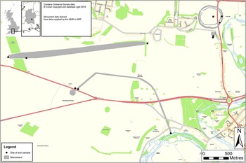


The Stonehenge Riverside ProjectFootnote 1 has provided an unprecedented opportunity for investigating the palaeo-environmental context of two of our nation's most significant Neolithic monuments, Stonehenge and Durrington Walls. This study synthesizes the results of a landscape investigation of the River Avon valley between Durrington and West Amesbury which analysed the palynological records held in palaeo-channels and the palaeosols and molluscan data from buried soils and ditches associated with many of the principal Neolithic sites in this landscape (fig 1).
Location map and the main sites investigated in the Durrington Walls and Stonehenge landscape, with the soil sample loci marked. Drawing: Mark Dover

Previous thinking about landscape change in prehistoric times on the chalk downlands of Wessex has suggested extensive Neolithic clearance, associated with intensifying agricultural impact, leading to extensive soil erosion and the consequent deposition of hillwash and alluvial material in both the dry valleys and river floodplains, increasing in severity from the later second millennium bc.Footnote 2 Would the specific palaeosol and palynological evidence for the Durrington-Stonehenge region corroborate this wider scenario of landscape change in prehistoric Wessex, or would the intensity of monument building in the later Neolithic give this landscape its own particular history? Also, how does this sub-regional sequence compare with what is known about prehistoric landscape change elsewhere on the chalk downlands of Wessex?
This paper aims to bring together all the known buried soil sequences from the Stonehenge and Durrington Walls environs, including work done by Richard Macphail in advance of the widening of the A303. In addition, the palaeo-channel and palynological data for the adjacent River Avon valley will be discussed, especially the palynological studies of Rob Scaife in the area immediately east of Durrington Walls, and comparisons made to the comprehensive molluscan studies by Michael J Allen undertaken as part of the Stonehenge Riverside Project, and previously in the same study area by Evans, Entwistle and Allen.Footnote 3
The implications of this new data will be considered against existing debates concerning the prehistoric development of the Wessex chalklands. This includes comparison with wider models of climax vegetational sequences and human impact for southern England,Footnote 4 landscape transformations associated with the change to sedentism and an agricultural subsistence lifestyle,Footnote 5 and intensifying land use and settlement in the Bronze Age causing widespread soil erosion and hillwash deposition across the chalk downlands.Footnote 6 Another question that will be considered is whether major later Neolithic activities at Stonehenge and Durrington Walls precipitated widespread and severe clearance, or was this area chosen because it was ostensibly already open countryside, as may be the case elsewhere in the English chalk downlands, such as on Wyke Down on Cranborne Chase,Footnote 7 on Winnall Moors in Hampshire,Footnote 8 at Dorchester,Footnote 9 on the southern chalklands generally,Footnote 10 and even on the Great Wold valley in Yorkshire.Footnote 11 The evidence for woodland versus grassland and the timing of major clearance often appear contradictory but, at a more detailed level, they are not. Indeed the soil, pollen and molluscan datasets in this study serve to reinforce the idea of the relatively localized nature of both woodland and grassland environments, and the diverse ecological mosaics once present.
Importantly, this research may also have implications for the relationship of the timber circle complex at Durrington Walls and the stone circles at Stonehenge via the River Avon during the third millennium bc.Footnote 12 In particular, Parker Pearson and Ramilisonina have postulated that there was a direct relationship between the two sites in the third millennium bc via the River Avon and the Stonehenge Avenue, involving a physical and incorporeal journey through death and into the afterworld.Footnote 13
The Avon valley record
A geoarchaeological survey of the associated River Avon floodplain was conducted as part of the Stonehenge Riverside Project. Unfortunately, access to much of the floodplain was restricted by a number of factors, including urban development, sewage/water works, the road network and limited access to private property. Accordingly, the available areas were located on the floodplain between Durrington/Bulford villages and the A303 east and south east of Durrington Walls henge, and in the vicinity of West Amesbury village to the south (figs 1 to 3).
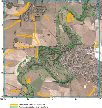
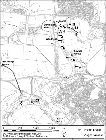
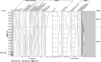
This survey involved aerial survey reconnaissance mapping by Rog Palmer (fig 2), ground-truthed by fifteen borehole transects (with 110 hand-augered holes) to discern the presence of palaeo-channels and stratigraphic deposit sequences present in the floodplain (figs 3 and 4). It was augmented by the retrieval of appropriate new cores for palynological analysis and associated radiocarbon assay from the Avon floodplain east of Durrington Walls and at West Amesbury (figs 3, 5 and 6; tables 1 to 4), building on the existing pollen record established by Scaife and Dimbleby for Durrington Walls.Footnote 14 These data were combined with the micromorphological analysis of palaeosols from a selection of the major Neolithic monuments in the Stonehenge landscape, namely from Amesbury long barrow 42, at the eastern end of the Greater Stonehenge Cursus, the eastern entranceway and Southern Circle of Durrington Walls, Woodhenge and the Stonehenge Avenue (at its Stonehenge and West Amesbury riverside ends) (see table 6), as well as previousFootnote 15 and new molluscan studies from these same sites by Michael J Allen.
The areas of colluvium and permanent pasture in the Avon valley between Durrington Walls and West Amesbury. Photograph: Rog Palmer (background from Google Earth/Digital Globe, 21 October 2002)

Location map of the augering transects (A–P) and the pollen profile locations (1994/just west of A15, 2005/A15, 2005/B8 and 2005/E1) in the River Avon floodplain in the Durrington to West Amesbury part of the Avon valley. Drawing: Mark Dover

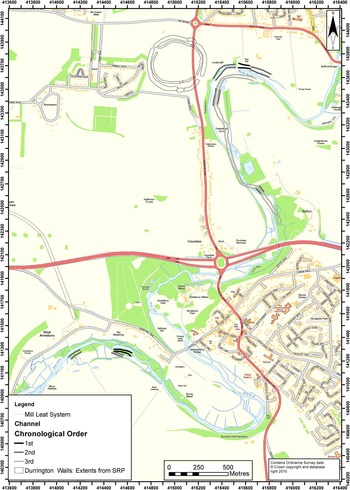
Conjectural map of the position of the main channels of the River Avon in prehistoric (1 and 2) and historic (3) times. Drawing: Mark Dover after Charles French

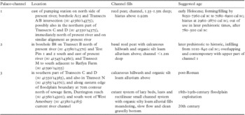
Suggested sequence of palaeo-channels in the River Avon floodplain between Bulford/Durrington and the A303/Amesbury

Durrington
A series of thirteen borehole transects were made across the Avon floodplain between Durrington/Bulford villages and the A303 (fig 3). This survey confirmed the presence of the early Holocene channel observed previously,Footnote 16 and identified at least two later palaeo-channels, all pre-dating the present meandering course of the River Avon (fig 4; table 1). Immediately east of Durrington Walls henge, the floodplain edge was buried by up to 1.5m of calcareous silt colluvial deposits, which thinned upslope.
The first and earliest palaeo-channel is visible on the modern ground surface as a slight contour and on the 1947 aerial photograph.Footnote 17 This channel is located more or less alongside and to the north of the current alignment of the river eastwards from the eastern entranceway of Durrington Walls and modern pumping station (fig 4; table 1). The present river at the Undercliff, just outside the eastern entranceway to Durrington Walls, must be more or less in the same position as the main prehistoric channel, since no other similar early Holocene channel deposits were evident. The first channel is about 1.5m deep and at least 50m in width. Its fills are characterized by a thin birch wood (Betula) detrital peat at the base (c 150–145cm), with reed peat (c 145–77cm) above, becoming more humified up-profile. This peat sequence is occasionally interrupted by lenses of calcareous silt/fine sand deposition (particularly at c 94–82cm), most probably resulting from the influx of eroded soil material from the adjacent chalk downland slopes. The upper part of the sequence comprises a silty humified peat (c 77–40cm) and very humified, floodplain peat (c 40–30cm) above.
Palynological investigationsFootnote 18 of the earliest palaeo-channel located where Transects A and B meet (at Transects A/B intersection and A15 on fig 3; table 2) revealed a complex set of environmental signals, complementing the vegetational sequence story previously recovered from the same palaeo-channel.Footnote 19 Obviously, river-channel contexts can cause taphonomic and interpretative problems for pollen analysis, affecting both pollen deposition, recovery and vegetational representation. But the consistently repeated stratigraphic sequences observed in the boreholes of Transects A and B of mainly quiet to still water conditions of accumulation insured good interpretative integrity to the repositories of pollen data examined in this project. Moreover, three pollen profiles were sampled in close proximity (at Transects A/B intersection, A15 and B8: fig 3).
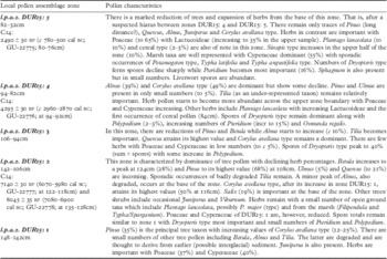
Pollen zone descriptions for borehole A15 in the River Avon floodplain east of Durrington Walls

Initially, water flow in the river channel was sufficiently fast to prevent any build-up of channel bed deposits. The formation of the first organic peat deposits indicates a change to standing water conditions and reed growth in the earlier Holocene. This floodplain margin landscape was dominated largely by open herbaceous communities composed mainly of sedges (Cyperaceae) and grasses (Poaceae) in pollen zone 1 (fig 5; tables 1 and 2). Pine (Pinus) and birch (Betula) were initially present, with an increasing presence of oak (Quercus), elm (Ulmus) and hazel (Corylus), probably on the surrounding downland as well as on the interfluvial slopes. This presumably implies the combination of woodland successional development with climatic warming of the early Holocene slowing down run-off processes, but then there was slight channel avulsion, cutting off parts of this first channel. What caused this slight change in channel course is a matter of speculation, but it could relate to increased run-off in the catchment as a consequence of the earliest inroads into this wooded environment in the later Mesolithic periods. It should be noted that large pine tree trunks were being used in three postholes beneath the Stonehenge car park in the eighth millennium bc.Footnote 20 Unusually, a substantial presence (c 20–50 per cent of dryland pollen) of pine persisted up until about 2900 cal bc (fig 5).
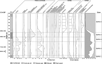
Simplified pollen diagram for channel 1 at the Durrington Pumping Station, Transect A, borehole 15, with radiocarbon dates given in bp. Drawing: Rob Scaife

This early woodland soon became dominated by a mixed deciduous tree assemblage composed mainly of hazel (Corylus), oak (Quercus) and elm (Ulmus) by about 8050–7260 cal bc (8640 ± 200 bp; GU-3239). Two additional radiocarbon dates were obtained slightly up-profile of 7080–6900 cal bc (8045 ± 35 cal bp; GU-22778) and 6070–5980 cal bc (7140 ± 30 cal bp; GU-22777) for pollen zone 2 (table 2). In this zone the woodland never attained a total frequency of more than 40–65 per cent (of dryland pollen) and was regularly depleted by a factor of 10–25 per cent (fig 5). This could relate to increased run-off in the catchment as a consequence of a number of substantial but episodic inroads made into this wooded landscape during the later Mesolithic and earlier Neolithic periods, possibly as a consequence of anthropogenic activities, including clearance and monument building on the adjacent downland.
Subsequently, there appears to have been a major hiatus, with an increase in valley sedimentation. This event was recorded by the presence of peaty silts and silts occurring from c 94–82cm in the palaeo-channel 1 profile beginning from about 2960–2870 cal bc (4295 ± 30 bp; GU-22776) (tables 1 and 2). It was associated with a vegetational change to far fewer trees and shrubs (fig 5), although oak (Quercus), hazel (Corylus avellana type) and lime (Tilia) persisted. A much more open downland coincidently began to develop with grasses and herbs and a wet, marshy floodplain environment, generally open but with sedges (Cyperaceae) and alder (Alnus glutinosa) on its margins. There is some evidence of human activity reflected in the presence of Plantago lanceolata, a very minor presence of cereal type pollen and increasing expansion of grasses (Poaceae) (fig 5; table 2). This situation appears to have been maintained throughout the third and second millennia bc. Indeed, both the predominantly open-country molluscan fauna (see below) and buried soil records of near ubiquitous rendzinas (see below) strongly indicate the establishment of a widespread grassland environment on the downland slopes by the time that the late Neolithic monuments such as Woodhenge, Durrington Walls and Stonehenge were in use from the early third millennium bc.
It was not until the late second/early first millennia bc that there was a gradual but major sustained clearance of the remaining woodland, culminating by about 780–500 cal bc (2490 ± 30 bp; GU-22775) (fig 5; table 2). This clearance phase was recorded by a substantial reduction in tree pollen frequencies from about 50 per cent to less than 20 per cent (fig 5). By this time grassland was predominant on the downland, with a substantial increase in sedges (Cyperaceae) on the floodplain, and strong signatures of disturbed ground associated with arable cultivation on soils suited to cultivation. Coincident with these marked vegetational changes was the deposition of calcareous humic silt deposits in the palaeo-channel, signifying disturbed soil material eroding off the downlands. Similar deposits are also seen in the second palaeo-channel in Transect B, borehole B8 (see below). This must be seen as a consequence of more widespread arable activities, increased run-off, possibly from un-embanked fields, and hillwash processes. Subsequently, perhaps by the Roman period, the valley bottom reached a relative period of stability with an alder and hazel carr woodland on the floodplain margins and an absence of constant flooding. The surrounding downland, however, remained ostensibly open and dominated by grassland but with some slight evidence of cereal cultivation and minor lime (Tilia) woodland remaining.
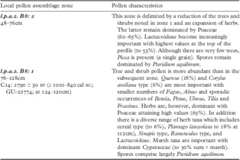
The second, gently meandering palaeo-channel system, generally less than 1.2m in depth, was located just to the north and east of the present river channel to the east/south east of Durrington Walls (fig 4). Its stratigraphy was best exemplified in borehole B8 of Transect B, as well as in Transects J, M and N, with a sequence of a basal reed peat becoming more humified up-profile and a calcareous silt deposit above (figs 3 and 6; table 3). The base of this sequence is dated to c 1010–840 cal bc (2790 ± 30 bp; GU-22774). Importantly, more inorganic calcareous silt deposits dominated the upper fill sequence of this channel. This upper fill appears to be derived from soil erosion from the associated downland slopes, probably consequent on agricultural exploitation and intensification as also seen in the pollen record (fig 5, pollen zone 5; fig 6, pollen zone 1). This landscape-wide process was taking place in later prehistoric and Roman times, probably also coincident with the more substantial aggradation of hillwash deposits observed within the dry valley occupied by the Durrington Walls henge and burying the Southern Circle.
Pollen zone descriptions for borehole B8 in the River Avon floodplain east of Durrington Walls

Simplified pollen diagram for channel 2, east of the Durrington Pumping Station, Transect B, borehole 8, with radiocarbon dates given in bp. Drawing: Rob Scaife

The pollen record from this second palaeo-channel was analysed from the borehole B8 profile (figs 3 and 6; table 3). This profile exhibited a dominance of herbs with a few trees and shrubs, which indicated a locally open environment throughout. Where trees and shrubs did exist, oak (Quercus) and hazel (Corylus) were typical of the very late prehistoric and historic periods with those taxa indicative of managed woodland. Lime (Tilia) was absent, but beech (Fagus sylvatica) was present in small numbers in the basal channel fill. Grasses and other taxa associated with grassland (eg Plantago lanceolata, ribwort plantain) were present and suggest that pasture was locally important. However, cereal pollen was also found, especially in the lower part of the profile, and indicates that arable cultivation was also being practised. In terms of deposit sequence, this channel appears to be contemporary with the upper third of the first palaeo-channel, and the pollen record is similarly indicative of the first millennium bc and into historic times. Thus, the vegetational history of this second palaeo-channel reflects the considerable stability and longevity of the floodplain.
A third palaeo-channel sequence (fig 4) was mainly characterized by a lower calcareous silt fill with an organic silt loam above, sometimes with a thin reed peat at its base. Its course runs just south of Transect B and was observed in Transects C and D, and then crosses over the current river to the south east to run more or less parallel to the present river channel. In terms of its deposit sequence, it is suggested that the calcareous silt is essentially a hillwash-derived deposit and the organic silt loam above is a combination of eroded topsoil and organic accumulation in the out-of-use channel. These colluvial/alluvial fills are probably indicative of the post-Roman/historic period, but deposited long before the creation of the current river course.
There is also a calcitic hillwash and organic silt loam infilled channel on the easternmost edge of the modern floodplain east of Durrington Walls, marked by a copse along the 70m contour line immediately north of the sewage farm. It is associated with a ditched channel for the nineteenth-century mill upstream and a series of embanked ‘lazy beds’ and leats, all probably no more than a few hundred years in age. There are a number of recently established fishponds and the sewage works, which now occupy much of the remainder of the present floodplain for the kilometre stretch north from the A303, which prevented further geoarchaeological investigations.
West Amesbury
Aerial survey of the West Amesbury area was hampered by the village, tree growth, ‘lazy beds’ and nineteenth-century mill channels (fig 2), but discerned at least two former channels in the present floodplain. Borehole transects E and F (fig 3) revealed a sequence of a c 0.75m thick organic mud beneath a shallow chalky wash deposit and reed peat, traced over a distance of c 400m east–west within the modern woodland to either side of the current river. Its position, just to the south west of where the Stonehenge Avenue may meet the river, is tantalizing.
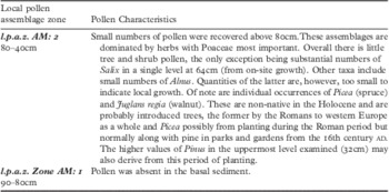
This extensive freshwater meander cut-off, or oxbow lake, was column-sampled for palynological assessment (E1 on fig 3; table 4). This assessment indicated that pollen preservation was sparse, often degraded, and absent in the base of the core.Footnote 21 From c 0.8m up-profile there were assemblages dominated by herbs with the exception of substantial willow (Salix), but with little evidence of trees and shrubs otherwise. Grasses (Poaceae) were largely dominant, along with a range of other taxa of grass-sedge mire and river floodplain affinity. Of specific note are individual occurrences of spruce (Picea) and walnut (Juglans regia). Both are non-native, introduced trees, the latter by the Romans to western Europe and possibly the spruce (Picea) also, although this tree is normally found with pine in parks and gardens from the seventeenth century ad.Footnote 22 Thus a post-Roman age is suggested for this palaeo-channel, while the presence of spruce may imply a date of c ad 1700 or later for the upper part of the profile.
Pollen zone descriptions of borehole E1 in the River Avon floodplain at West Amesbury

This oxbow-lake phase was succeeded by a shallow palaeo-channel of a similar scale to today's river, c 0.7m deep and to the south of the present course (fig 4), between the modern riparian woods and floodplain pasture zones. It is characterized by an upper calcareous silt loam fill, derived from hillwash, over a thin humified peat. These basal humified peats were assessed for pollen and found to contain a very open floral assemblage most probably indicative of historic to recent times.Footnote 23
Palaeosols in the stonehenge environs
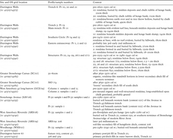
The Stonehenge Riverside Project investigated a number of major monuments (table 5) within the Stonehenge to West Amesbury landscape, which enabled a range of buried soils to be investigated using micromorphological techniques (table 6).Footnote 24 Particular attention was given to the eastern entranceway to Durrington Walls, the western terminal of the Greater Stonehenge Cursus, the West Amesbury 42 long barrow at the eastern end of the same cursus, to Woodhenge and to the Durrington 67 barrow immediately to its south east, to the Stonehenge Avenue immediately to the north of the monument and the A360 road, and the southern end of the purported route of the Stonehenge Avenue at West Amesbury, where it meets the River Avon (fig 1).
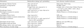
Rounded radiocarbon dates of some of the major monuments in the Durrington–Stonehenge–West Amesbury study area (after Parker Pearson et al 2004, 2007, 2009 and forthcoming b and c)

*Note new higher precision date
Soil sample locations, profiles, contexts and dating in the Durrington–Stonehenge–West Amesbury environs

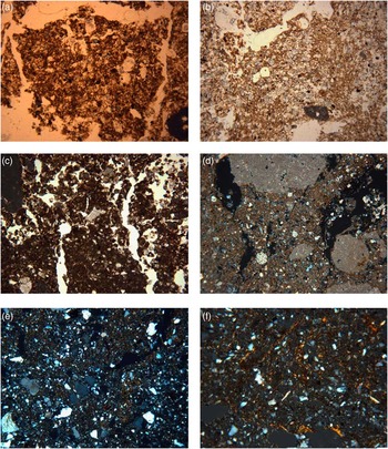
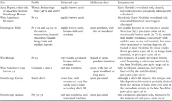
A range of past soil types is present in the wider Stonehenge and Avon Valley landscape – from argillic brown earth to brown earth and rendzina (figs 7 to 9; table 7).Footnote 25 As might be expected in this chalk downland region, the most common soil type present that pre-dates the Neolithic and Bronze Age monuments is the rendzina. These soils are thin (usually <250mm), bioturbated, chalk-rich, single horizon soils developed on the weathered chalk substrate (figs 7a–d).Footnote 26 This soil type exhibits a variety of thicknesses as a result of variable intensities of truncation and the deliberate removal of turf. On only a few occasions is an in situ turf present, such as beneath the Neolithic long barrow West Amesbury 42 at the eastern end of the Stonehenge Cursus (fig 7c). Rendzina soils were found beneath most of the late Neolithic structures associated with the eastern entranceway to Durrington Walls, below the external bank on the north-eastern side of Woodhenge, and beneath the Stonehenge Avenue banks immediately to the north east of the Heel Stone (figs 7a and b). Thus rendzina soils appear to dominate this chalk downland landscape by the mid-fourth to mid-third millennia bc. Their formation and maintenance are consequent on established calcareous grassland with an abundant and active earthworm population.Footnote 27
A selection of soil photomicrographs from buried soils in the region exhibiting the main soil types of argillic brown earth and rendzina. (a) Photomicrograph of the organic, fine sandy loam fabric of the Ah horizon of the rendzina buried soil beneath the western bank of the Stonehenge Avenue (frame width = 4.5mm; plane polarized light); (b) photomicrograph of the mixture of the micritic fine sandy loam fabric of the A/C horizon of the rendzina buried soil beneath the western bank of the Stonehenge Avenue (frame width = 4.5mm; plane polarized light); (c) photomicrograph of the bioturbated humic fabric or turf of the rendzina buried soil beneath West Amesbury 42 long barrow (frame width = 2.5mm; plane polarized light); (d) photomicrograph of the micritic sandy loam fabric mixed with fine gravel-sized chalk rubble of the lower A/C horizon of the rendzina buried soil beneath West Amesbury 42 long barrow (frame width = 4.5mm; cross polarized light); (e) photomicrograph of weakly reticulate dusty clay striated fine fabric in the base of the buried argillic brown earth soil at West Amesbury Riverside hengiform site (frame width = 4.5mm; cross polarized light); (f) photomicrograph of the reticulate golden clays in the sandy clay loam of the buried argillic brown earth soil in the subsoil hollow beneath the henge bank at Durrington Walls (frame width = 2.5mm; cross polarized light). Photographs: Charles French

Summary description and interpretation of the range, location and dating of palaeosol types and molluscan data present in the Durrington–Stonehenge–West Amesbury study area

In contrast, where the line of the Avenue meets the River Avon at West Amesbury, a truncated argillic brown earth survived beneath the largely eroded outer bank of a small hengiform monument built about 2480–2280 cal bc (fig 7e). This soil had probably developed in the earlier Holocene associated with stable, well-drained, woodland conditions.Footnote 28 It has subsequently been disturbed and truncated, removing its upper half prior to burial by thin hillwash and alluvial deposits associated with a locally high groundwater table and its proximity to the present River Avon. In addition, better preserved argillic brown earths were discovered in test pitting on the line of the new A303 route on either side of Stonehenge Bottom valley adjacent to the A344/303 intersection.Footnote 29 It has been suggested that these former Early Neolithic, non-calcareous, woodland soils occurring on flinty silty drift had been demonstrably cleared, as well as probably ploughed and disturbed by animals, prior to being buried by later humic colluvial deposits.Footnote 30
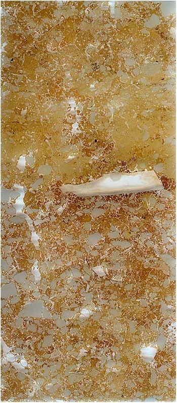
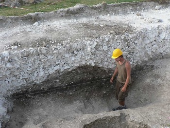
Decalcified brown earth soils were also discovered beneath the chalk floor of one of the small rectilinear structures (851) within the area of what was to become the eastern entranceway of Durrington Walls henge (fig 8) and in Trench 6 beneath the eastern bank of the henge (fig 9). Although the buried soil beneath the chalk floor of structure 851 was truncated and its organic A horizon removed, it is a well-structured, fine sandy clay loam, with pure and impure clay coatings increasing down-profile, that characterize an argillic horizon of a former brown forest soil.Footnote 31 The buried soil beneath the eastern henge bank also exhibited a similar clay-enriched lower B horizon (fig 7f) within a subsoil hollow (fig 9). The presence of these soils demonstrates that woodland soil development of varying intensities had occurred in this area earlier in the Holocene. But prior to burial in the mid-third millennium bc, there had been widespread soil change to rendzina soils associated with grassland. This radical transformation process was most probably associated with human activities, especially clearance and intensive land use, mainly of managed grassland.
A scan of the thin-section slide through the pale yellowish-brown chalk floor of the later Neolithic House 851 on the eastern side of Durrington Walls above the truncated chalky brown earth soil (slide = 14cm in length). Photograph: Elisabeth Rutherford

The chalk rubble and turf/soil core of the henge bank above an in situ turf and humic brown earth buried soil with a tree-throw hole beneath, in Trench 6, Durrington Walls. Photograph: Charles French

The few occurrences of former argillic brown earth soils at Durrington Walls within pre-mid-third-millennium bc burial contexts also suggest that different soil development trajectories occurred over very short spatial distances. Rendzinas were fully developed and predominant in most areas, but in a few other areas brown earths or argillic brown earths were also present as ‘survivors’. This could reflect the close proximity and mosaic variation in land use, survival of small patches of woodland, such as those of lime woodland postulated from the pollen data, or different drainage patterns, and/or different intensities of monument and settlement building, as well as agricultural impact.
It is rare to find buried soils that reflect the transition features from woodland to grassland; unusually, two examples were found beneath the later Neolithic henge banks at both Durrington Walls and Woodhenge. In the field, these buried soils appeared to be rendzinas; in thin section these exhibited some features indicative of a once better-developed brown earth. This was also observed to a lesser extent in the buried soil associated with the Southern Circle within the interior of Durrington Walls. These transitional brown earth soils tend to be much thicker (c 0.3–0.5m) and exhibit some structural development and illuviation of organized fine silty clays indicative of some pedogenesis and the development of a weathered B horizon typical of a brown earth.Footnote 32 Indeed, the impure (or dusty) clay coatings observable throughout the fine groundmass in these soils (figs 7e and f) are indicative of illuviation (or down-profile movement of silt and clay) consequent upon the disturbance of the upper part of the soil profile, a feature that may equally reflect clearance as well as other human activities.Footnote 33
Definitive instances of past arable agriculture in this landscape are extremely rare. There were only occasional, very slight indications in the soil micromorphological features of any of the palaeosols to suggest disturbance caused by arable agriculture. The only positive instance in the soil record of arable agriculture and additions to the soil of probable Neolithic date occurred along the A303 immediately east of Stonehenge (table 7).Footnote 34 Here the palaeosol was a decalcified brown earth that was phosphate enriched, trampled by livestock and then ard-ploughed prior to being buried by hillwash deposits. Nonetheless, in the pollen data from the River Avon at Durrington, and possible hints in the molluscan data from Durrington Walls,Footnote 35 there is some evidence of agricultural disturbance prior to the late Neolithic in the vicinity. Thus good and plentiful evidence for early prehistoric arable agriculture in terms of field boundaries, plough marks, cereal pollen and soil micromorphological signatures, for example, is apparently minimal in this landscape, but could be substantially under-estimated and obscured due to the subsequent landscape modifications that took place in later prehistoric and historic times.
In all of the soil profiles examined, there is a predominance of very fine sand and coarse silt-sized components (fig 7b), suggesting a loessic-like input. Nonetheless, no definitive well-sorted wind-blown sediments were seen in any ditch fill or soil horizon, although the secondary fill of the southern ditch of the Greater Stonehenge Cursus appeared to be so in the field. This strongly suggests that the later Quaternary loess that is believed to have blanketed much of this landscape was only variably present in places on the upper surface of the chalk substrate.Footnote 36 It is possible that, by the time of early Holocene soil development, there were only a few remnant survival zones of loess present and these were sometimes exposed and reworked by human activities in prehistoric times, such that they could become mobilized and re-incorporated in the topsoils of the day by wind blow. Moreover, the stone-free calcareous sandy loam deposit in the southern ditch of the Greater Stonehenge Cursus testifies to bare and exposed soil surfaces in the immediate vicinity during later Neolithic times, such as would be caused by arable agriculture.
Comparative molluscan data
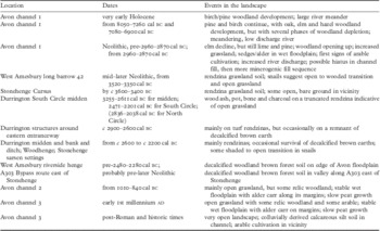
Situating the pollen and soil data with the abundant molluscan data for the region gives a remarkable degree of corroboration as to the sequence of landscape and land-use change in the Durrington–Stonehenge Avon study area (table 8).
Summary interpretations of the combined molluscan, soil and pollen data by period

The molluscan assemblage from Wainwright's 1968 excavations of Durrington Walls suggested an initial phase of woodland clearance and cultivation preceding a very open grassland environment, all occurring before the henge bank was constructed.Footnote 37 These snail data compare well with the pollen data obtained from the Durrington pumping station profile (fig 5, borehole A15). In contrast, Dimbleby observed open vegetation dominated not by grasses but by bracken from a late prehistoric buried soil under hillwash in the interior of the henge.Footnote 38 This apparent difference may be explained by the disturbed type of context sampled, preservation bias and a later time period represented, but does give some indication that hazel woodland and disturbed ground existed in later prehistoric times.
The openness of the Neolithic landscape at Durrington Walls was previously regarded as unusual. Certainly some other pollen and molluscan analyses indicated that the outer fringes of the chalk downlands remained wooded to some extent well into later prehistoric times, for example, at Snelsmore near Winchester,Footnote 39 Rimsmoor, Dorset,Footnote 40 and Mount Caburn, Sussex.Footnote 41 However, recent work in a number of locales on the chalk – such as on Cranborne Chase,Footnote 42 Stonehenge,Footnote 43 DorchesterFootnote 44 and the Isle of WightFootnote 45 – suggests that partly open grassland/partly wooded landscapes were present over large areas of downland in very early prehistoric times, with strong hints that the considerable degree of openness may have had its antecedents in the earlier Mesolithic, in contrast to the Sussex Downs.Footnote 46
Molluscan data obtained from several other Neolithic sites in the vicinity of Durrington Walls and Stonehenge tend to corroborate this story of a substantially open landscape from earlier Neolithic times. For example, molluscan assemblages from the eastern ditch of West Amesbury long barrow 42 showed open conditions, although the basal fills were not analysed.Footnote 47 New samples taken by Allen from the base of the ditch also suggest an open landscape, but possibly with more mixed open-shaded conditions exhibited in the secondary fill. Whether this is reflective of local ditch vegetation regeneration or the presence of woodland refugia within the immediate landscape is not verified, but new pre-mound buried soil samples should clarify this.Footnote 48 Certainly, the molluscan assemblages from the Greater Stonehenge Cursus examined by EntwistleFootnote 49 and AllenFootnote 50 have produced poorly preserved but typical open-country assemblages with a lack of shade-loving species, as also found near the eastern terminal of this cursus.Footnote 51
In contrast to these open assemblages, the snails from the Stonehenge Lesser Cursus, also analysed by Entwistle,Footnote 52 reflected a more mixed wooded/shaded/open molluscan assemblage, but were influenced by chalk rubble micro-habitats. In addition, a tree-throw pit associated with the western bank of the Stonehenge Avenue, just north of the Heel Stone, produced a shade-loving assemblage, another very rare occurrence in this landscape, but in a rendzina soil matrix.Footnote 53 There was also evidence from both the buried soil of the pre-henge bank and a subsoil hollow at Woodhenge of an initially woodland environment.Footnote 54 Then there is evidence of disturbed, possibly cleared, ground (indicated by Pomatias elegans) on established grassland by the time that the bank was erected.Footnote 55 This shaded to open habitat transition was similarly observed at Woodhenge with mixed shade/open conditions apparent in the snail faunas from a Neolithic pit (033) and in the ring-ditch of the associated Durrington 67 barrow.Footnote 56 By Bronze Age times this site had become the same calcareous grassland as observed at most sites in the region.Footnote 57
The molluscan analysis from the Trench 6 sequence through the old land surface and tree-throw and subsoil hollow pits beneath the eastern henge bank at Durrington Walls indicated woodland shade conditions, coincident with brown earth soil development.Footnote 58 This was then followed by disturbance before becoming more open long grassland, all before construction of the henge bank at c 2620–2300 cal bc. A more mixed, shady to open assemblage was also observed in the pre-late Neolithic (pre-2470–2200 cal bc) buried soil associated with the Southern Circle within the henge interior. Together, these sequences at Durrington Walls and Woodhenge must represent the transition from a partly wooded to a grassland environment, with a few shady refugia remaining in an increasingly open grassland landscape. Although there are variations in the expression and timing of the vegetation succession, the transition to grassland had occurred well prior to the henge banks of Durrington Walls and Woodhenge being constructed in the mid-third millennium bc. This is also corroborated by the buried soil record and the palynological record in palaeo-channel 1 east of Durrington Walls, all in pre-late Neolithic burial contexts.
Molluscan data from the slightly later but near-adjacent sites of the Bronze Age barrows at Earl's Farm DownFootnote 59 and on King Barrow RidgeFootnote 60 and the Late Bronze Age ditches at Earls Farm DownFootnote 61 exhibit a virtual absence of shade-loving species. These assemblages are dominated by Pupilla muscorum, which favours areas devoid of vegetation such as patches of broken ground from sheep grazing on chalk downland slopes.Footnote 62 In addition, there is a predominance of Vallonia costata over V. excentrica, the former a pioneer of freshly exposed soil surfaces but indicative of short-turfed grazed downland, versus V. excentrica, which is more common in open arable land.Footnote 63
The changing soil landscape and wider implications
Although it is regularly suggested that the modal soil type of the Wessex chalklands is of thick brown earth type,Footnote 64 this soil type has only rarely been found in association with Neolithic and Bronze Age monuments in Wessex.Footnote 65 In only a few instances have thick, well-developed, argillic brown earth soils been observed beneath Neolithic structures, such as at the Easton DownFootnote 66 and Hazelton North long barrows.Footnote 67 In the upper Allen valley of Cranborne Chase there is instead abundant evidence for well-developed rendzina soils associated with grassland being almost ubiquitous on some large areas of the chalk downland by the later Neolithic.Footnote 68 At Durrington Walls and the Stonehenge environs, the very few occurrences of both brown earth and argillic brown earth soil profiles are atypical of all the other buried soil profiles observed there and in their vicinity. However, these occurrences undoubtedly demonstrate the real range of soil types and provide a glimpse of both the early Holocene landscape and the changing and variable landscape/soil/vegetational mosaic that once existed in Mesolithic to earlier Neolithic times. Nonetheless, these woodland soils must have been much more widespread, but perhaps not ubiquitous as previously suggested, across this part of the downland landscape prior to the late Neolithic.
By any measure the palaeosols and vegetation present at Durrington Walls and in its environs had been drastically modified by the early third millennium bc. One can envisage some patches of woodland and their associated brown earths remaining on the downs, but the environment on the downland slopes was largely the open grassland associated with thin rendzina soils, perhaps with a few remnant patches of trees and shrubs, with sedges and alder along the margins of the floodplain.
Despite such variations existing throughout the Neolithic, thin grassland rendzina soils predominated in the third millennium bc in the later Neolithic Durrington–Stonehenge landscape. Wherever these soils were de-vegetated and exposed, the predominant very fine sand/silt soil size and texture made them prone to movement by wind and water, betraying their late glacial loessic origins. Definitive evidence of arable agriculture is very limited, especially in the palaeosol record, and is rarely evident in the palynological record from the Avon palaeo-channels until later prehistoric times. This is not necessarily reflective of the whole story, but is a cumulative result of long histories of post-depositional distortions, especially associated with later hillwash erosion processes. Consequently it is possible that both woodland and cultivated soils could be much under-represented in the evidence base.
Nonetheless, as a result of examining thirty-two buried soil profiles in a relatively confined landscape defined by the project's remit, it is apparent that soil types varied within very short distances in the Durrington–Stonehenge landscape in prehistoric times. Significantly, this landscape was comparatively stable in the later Neolithic and Bronze Age periods, perhaps reflecting longer-term land-use patterns. It is not just the recognition, identification and interpretation of landscape vegetation character and land use that is important, but the changing fine and coarse-grained ecological mosaics that may have been present in the past.Footnote 69 For instance, on the eastern slope of Stonehenge Bottom valley just south east of Stonehenge, there is evidence for woodland, clearance, stock management, arable and colluviation all occurring from the Neolithic period onwards. In contrast to both sides of the eastern entranceway of the Durrington henge, along the route of the Greater Stonehenge Cursus and the Stonehenge Avenue immediately to the north of the Heel Stone, there are extensive areas of long-term established grassland associated with rendzina soils throughout the late fourth and third millennia bc. But on the north-eastern circuit of the Durrington bank and at Woodhenge, woodland soil appears to have survived for a little longer, with less soil erosion, prior to these late Neolithic monuments being built. Nevertheless, this widespread soil change to grassland rendzinas need not be viewed as wholly degradational in consequence. Rather, it may well have been that the open grassland landscape was viewed as desirable, especially if people in the Neolithic were more engaged in pastoral rather than arable activities,Footnote 70 as well as creating open views of their burial and ceremonial monuments.
The interior area of Durrington Walls henge exhibited poor soil development and severe post-clearance soil erosion. The soil/sediment profile associated with the South Circle exhibits a contemporary rendzina soil buried by substantial amount of eroded soil material that accumulated between later Neolithic and Roman times, and particularly again in post-Roman times after a brief period of stabilization and incipient soil development. Severe soil erosion was also very noticeable in the eastern entranceway area of the henge, where an incipient rendzina soil is present beneath chalk rubble hillwash deposits, suggesting that there was removal and truncation of the original soil by water erosion events emanating from the interior of the henge in post-late Neolithic and post-Roman times. Sheet erosion and overland flow mechanisms probably removed much of the exposed soil in the interior of the henge, leaving a denuded, gravel fan-like area in the eastern entranceway. This type of event has been observed elsewhere – for example, at Strawberry Hill, Wiltshire,Footnote 71 and Ashcombe Bottom, East Sussex.Footnote 72 Much of this muddy calcitic colluvial mud was either probably deposited at the Undercliff, where several metres of hillwash were observed in this project, and/or carried away down-river. This process in itself implies post-late Neolithic bare soils and intensive later agricultural land use within the henge. Subsequently, in post-Roman times, colluvial aggradation began to fill and smooth the interior contours of Durrington Walls to create what is visible today, a longer-term process no doubt associated with arable agriculture.
Conclusions
Although it would have been desirable to have had many more well-preserved buried soil profiles and pollen sequences from the Durrington Walls to West Amesbury reach of the River Avon, the weight of available soil, pollen and molluscan evidence from the Durrington–Stonehenge–Avon environs is pointing to a consistent story of landscape development. This landscape sequence appears to exhibit a different and more variable course of events than the wider models of climax vegetational sequences and human impact have suggested for many other parts of southern England in the earlier Holocene.Footnote 73 It is not just a straightforward Holocene vegetational succession involving the full development of a mixed deciduous woodland in the earlier Mesolithic, then strong human impact involving clearance from the mid-fourth millennium bc onwards, with associated elm decline and widespread arable agriculture leading to extensive opening up of the downland and associated colluviation on a grand scale throughout later prehistoric times.
The available Durrington–Avon data portrays partial and variable woodland in successional development in the earlier Mesolithic. The Avon palaeo-channel 1 pollen record suggests intermittent woodland development and modification and opening-up of this landscape in the later Mesolithic and earlier Neolithic. Pine lingers strongly in edaphically suited parts of this landscape throughout the Mesolithic and Neolithic periods. Oak, elm and latterly lime are present in relatively low frequencies, but with hazel more abundant. In addition, evidence of the relatively quick early Holocene vegetational succession from pine and birch to mixed oak/elm/lime/hazel woodland is only patchily present at StonehengeFootnote 74 and within Durrington Walls.Footnote 75
Major soil and vegetational changes appear to have culminated by the early third millennium bc. By the time of the construction at Durrington Walls and Woodhenge within the early third millennium bc, stable calcareous grassland predominates on the downland slopes, but there is still a considerable woodland component elsewhere in this landscape. These events appear to be coincident with a major hiatus in floodplain development from about 2900 cal bc. This is reflected by episodic increases in channel sedimentation, quite dramatic tree and shrub clearance coincident with more open downland reflected by the marked increase in grasses, some indications of anthropogenic activity hinted at by the increased but relatively minor presence of Plantago species and cereals, and an expanding wet floodplain with sedges and alder along the river's edge.
Nonetheless, stable grassland associated with rendzina soils predominated over arable, especially around the major later Neolithic monuments of Durrington Walls, Woodhenge and Stonehenge. It suggests that this was a culturally desired, determined and managed landscape. This has been previously postulated for parts of Cranborne Chase associated with the Dorset Cursus and Wyke Down henges, such as Wyke and Bottlebush Downs.Footnote 76 Perhaps Neolithic farmers soon recognized that fine-textured and thin downland soils were not always ideal for long-term arable use as they are prone to drying out, easily depleted of nutrients and susceptible to downslope erosion and wind-blow, unless the concepts of organic manuring and soil conservation were understood.
Alder–hazel carr woodland and sedge-dominated mire appear to have persisted alongside the gentle meanders of the River Avon east of Durrington Walls. Significantly, this pertained throughout prehistoric times, and even increased in extent during later prehistoric times and into the Roman period. A reminder of this riparian vegetation exists today in the form of open beech, alder and willow woodland growing alongside the River Avon to the south east of Durrington Walls towards the A303 highway. It would have made access to the river more difficult in prehistoric times, raising questions about the ease of physical connectivity between Durrington Walls and Stonehenge via the River Avon in the third millennium bc; it would also have made the journey down-river more secluded.
It is not until the early–mid-first millennium bc that the Durrington–Stonehenge landscape becomes a fully open landscape, with a mixture of grassland and, increasingly, arable land. Significantly, the intensifying arable use of the landscape led to more soil erosion, transforming the downland and floodplain landscapes alike. Soil thinning of the rendzinas on the upper–mid-downland slopes is evident in the borehole transects, along with shallow hillwash accumulation on the lower slopes and to a lesser extent in the dry valleys (of c 10–55cm in thickness), and the more substantial aggradation of eroded calcitic silts within former channel meanders in the Avon floodplain. The only exceptions where substantial depths of hillwash accumulated in post-Roman times were observed within the dry valley interior of Durrington Walls henge itself and over the Undercliff immediately east of the Durrington henge's eastern entranceway. This erosion complex implies later and long-lived cultivation within the henge and probably also substantial denudation of the chalk henge bank.
So, is this landscape ‘special’ or different? It appears to have been largely transformed to a stable and quite open grassland landscape by late Neolithic times or the third millennium bc. Nevertheless, this landscape was almost always partly open and underwent significant inroads into its woodland cover during previous earlier Neolithic and Mesolithic times. Accordingly, the natural soil type tends towards thin, poorly developed brown earths and rendzinas under grassland. Thicker, better developed woodland soils only survived in relatively few patches of this downland. Was this landscape pre-adapted to this developmental history? Perhaps, but this is hard to prove with the currently available edaphic and archaeological records. This is probably as much due to the area being a strong focus for earlier prehistoric activity, in terms of people, animals and monument building, whether associated with mobile and/or more sedentary life-styles.
Grassland also has to be maintained, usually by livestock grazing in some numbers,Footnote 77 which in turn has implications for postulating larger numbers of people living in and managing animals in this landscape. This point has recently been emphasized by a radiocarbon and population study of farming communities in Neolithic Britain by Collard et al,Footnote 78 which suggests much greater population density in the Neolithic, as well as the possibility of a more animal-based economy for southern England in the Early Neolithic.Footnote 79 Maybe this part of the chalk downland landscape is important because of its greater ready availability of stable grassland soils than many other, more wooded, parts of the downland, combined with the strong lingering component of pine in the available woodland which would have been ideal for large, straight timber for monument building.
Acknowledgements
We would like to thank the directors of the Stonehenge Riverside Project – Mike Parker-Pearson, Josh Pollard, Colin Richards, Julian Thomas and Kate Welham – for inviting us to be part of the project. Both Charles Rowlands and Stan Rawlins are thanked for allowing access to their land in the Avon valley adjacent to Durrington Walls; without their co-operation the geoarchaeological survey would have been impossible. Thanks also are due to Mike Allen, David Norcott and Kate Page-Smith, who helped with the augering in the field. Funding was gratefully received from the McDonald Institute for Archaeological Research, the McBurney Geoarchaeology Laboratory, Department of Archaeology and Anthropology, University of Cambridge, and the Arts and Humanities Research Council.
Charles French would also like to thank Julie Boreham (Earthslides) and Tonko Rajkovaca, McBurney Geoarchaeological Laboratory, Department of Archaeology and Anthropology, University of Cambridge, for making the thin-section slides, and Dr Richard Macphail, Institute of Archaeology, University College London, for freely giving his thin-section slide information and for helpful interpretative discussions. In addition, he would like to thank Elisabeth Rutherford, Alejandra Diaz and Boriana Boneva, who assisted with some of the micromorphological descriptions, and Rog Palmer, Rob Scaife, Mark Dover and David Redhouse for providing and producing the final figures.