Introduction
This article looks at ‘civil stations’ or colonial administrative towns (also known as zilla sadar) in provincial areas of Bengal,Footnote 1 British India, in the nineteenth century, to interrogate larger ideas of difference and dependence between town, country and city (Figures 1 and 2). A body of critical scholarship in the last decade has moved away from an older focus on the dualities of ‘white’ and ‘black’ spaces to address the dynamics of mediation or negotiation between different agencies in the colonial milieu, and the ensuing heterogeneous landscapes of colonialism.Footnote 2 This article extends the ambit of such analytical re-configurations to engage with one of those physical and conceptual sites that have been severely marginalized within the discourse of colonial spatiality – the so-called peripheral spaces of mufassil Footnote 3 or provincial towns of Bengal. In so doing, it reads big cities, suburbs, provincial towns, their own peripheries and interior villages as a composite space in terms of their networks of functioning.
Bengal (shaded portion on eastern side) and other British territories in India, late eighteenth century. Source: Cambridge Modern History Atlas (London, 1912).

Sadar towns, Lower Bengal.

The article argues that the idea of peripheries or sub-‘urban’ conditions cannot always be delimited to defined belts around cities. Rather, they are a result of more complex dependence–autonomy relationships and ensuing flow of cultural practices, sometimes even between physically far-flung areas. This is particularly true of the settlement geography of colonial governance in Bengal. In such a scenario, designations such as ‘urban’, ‘suburban’ or ‘non-urban/rural’ are themselves called into question. The article discusses how district headquarter towns in provincial areas of colonial Bengal could never be firmly fixed within such clear-cut designations. They were ‘fluid’ spaces shaped by the continuously shifting roles they played with respect to a variety of constituencies and perspectives.
In order to attend to these varied constituencies, I have chosen sources that reflect on the conditions of inhabiting these spaces, rather than only those that state the normative governmental functions. The effects of colonial governmentality that inflected the life of the muffasil, I argue, may not be understood by studying ‘governmental’ sites alone. It is instead essential to examine the extended sites of everyday life where governance was practised and lived, and around which the inhabitants built an entire lifestyle. Consequently, I have drawn upon intensive on-ground physical surveys of buildings and urban patterns – correlating these with local urban-historical accounts, documenting family histories and narratives in person, and the reading of literary material.
Split-images of provincial urbanism
In his account of a civil station – a provincial administrative town in colonial Bengal, George F. Atkinson, a British civil servant, gives the following description in the late nineteenth century:
‘our station’ rejoices in the euphonious appellation of Kabob; it is situated in the plains of Dekchy, in the province of Bobarchy. Far from the busy haunts of a civilised world, and the traffickings of men, and plunged in the wild retirement of a luxuriant jungle, smiles Kabob, ‘the loveliest village of the plain’, basking beneath the rays of orient sun. Oh! If there be a paradise upon earth, – I suspect it must be this!Footnote 4
He then goes on, in apparent contradiction, to describe the very same station as ‘a hotter and duller hole is not to be discovered by the most enterprising and enthusiastic tropical traveller – remote, unfriended, melancholy, slow’.Footnote 5
Though presented as a spoof, Atkinson's account is telling of the contradictions that constituted colonial provincial stations. In the beginning, he differentiates the station as being removed and different from the busy urban world of large cities such as Calcutta, emphasizing its essentially non-urban, rural character and the value of these qualities in the context of intensive urban scenarios. The second part of Atkinson's account is suggestive of the ordinariness and marginality of such places, of their subordinate role and the sense of isolation and frustration arising from this. Atkinson was not being entirely original. As early as 1775, Robert Lindsay, a young civilian appointed the collectorFootnote 6 of Sylhet, noted his great disappointment at discovering that the provincial town was ‘only an inconsiderable bazaar or market place’.Footnote 7 Around the same time as Atkinson, Prasannamoyee Devi, a middle-class Bengali woman, describes another civil station, Krishnanangar, in terms of its green, idyllic and exotic environment.Footnote 8 In the mid-nineteenth century, Jogesh Bidyanidhi, an eminent Bengali academic, recalls his move as a child from his native village to the town of Bankura; Bidyanidhi views it clearly as a move to an urban area.Footnote 9 It is such contradictions, instability of perceptions, problems of description and gaps between imagined and experienced realities that characterized the provincial civil station in colonial Bengal and made it many things at the same time – a sort of a schizophrenic entity that could be perceived very differently depending on the vantage of the viewer.
Colonial governance, mobility and provincial urbanization
Civil stations were quintessential products and key sites of colonial provincial administration.Footnote 10 After the granting of the diwani or the rights of revenue collection of the provinces of Bengal, Bihar and Orissa to the East India Company by the Mughal emperor in 1765, the ‘District’ or spatial unit for revenue collection came to be one of the most significant components of the colonial revenue administrative machinery. Later, after the British crown assumed direct rule of India in 1858, it also served as the basic political-administrative unit for imperial governance itself. The district-headquarter town or the zilla sadar (or sadar in common parlance) represented a space between the big city and the country, the urban and the rural, the central government and sub-divisional offices (Figure 3). Twenty-four sadar collectorships (revenue collection centres) were established in and around 1786,Footnote 11 and by the 1870s the number had more than doubled to 53.Footnote 12 In most regions, the sadar came to be the pivotal administrative location, where people reported for paying taxes, where litigations were pursued in district courts, where men moved from villages as they became increasingly employed in administrative offices, where networks of professionals and businessmen grew, where new institutions flourished. Centred on the core function of governance and poised between different hierarchies of administration and scales of urbanity, these towns came to embody an alternative and intermediate way of living and working between country and city.
Jessore: sadar, Jessore district. Photo: Pradeep Sen.

Most sadar towns witnessed a substantial influx of people from rural areas in the first half of the nineteenth century in search of urban employment, as the formal infrastructure of revenue governance in these towns was being set up. Despite this, the overall urban population in the mufassil remained exceedingly low up until the early twentieth century. The urban population of Bengal grew from 1872 to 1901 by almost 25 per cent; the latter only represented 5 per cent of the total population.Footnote 13
Colonialism forged radical and contradictory connections between previously less-connected locations. One of the key reasons behind this was the strongly hierarchical character of colonial revenue administration. By 1793, provincial governance was shaped into a somewhat decentralized, but oligarchic form of district administration, with two centres of power – the district collector (in charge of revenue matters) and the district judge (in charge of civil justice). Magisterial power for administration of criminal justice was at different points of time combined with the collector's or the judge's duties. However, even after such decentralization, the very nature of colonial administration, arranged hierarchically from the headquarters at Calcutta to district headquarter and sub-divisional towns,Footnote 14 right down to the tax collection estates in the countryside, coupled with the higher mobility brought about by a growing network of road, rail and water transport by the mid-nineteenth century, entailed continuous movement of people between city, town and country.
The ways in which colonial governance virtually necessitated links between cities, towns and rural areas were many and varied. The justice system, for example, was arranged in a strictly tiered manner. Appeals from the munsiff's courts (lower courts) in interior areas were heard in the district level diwani (civil) and fouzdari (criminal) courts located in zilla sadar towns, and those from district courts were heard first in provincial courts of appeal at Calcutta, Dacca and Murshidabad, and then in sadar diwani and sadar nizamut (civil and criminal) courts at Calcutta. This meant that to receive justice, people had physically to move between different spatial locations such as villages, zilla sadar towns and Calcutta. Other than this, the colonial justice delivery system itself also comprised of mobile components. For example, judicial officers from the courts of circuit in Calcutta, Dacca and Murhsidabad and later, after 1829, the divisionalFootnote 15 commissioners (who acted as sessions judges) moved from town to town for settling cases related to serious offences. Even in revenue administration, many sub-divisional towns did not, till the mid-nineteenth century, have proper treasuries, and revenue was collected at the zilla sadar. Thus, by its very nature of functioning, colonial governance involved multiple connections between a range of urban and rural locations. It caused lives to be split across and lived in many different spaces simultaneously, and intermediate locations such as zilla sadar towns to acquire many different characteristics. Central to this was the dichotomy of urban and rural identities and the notion of resources and quality of life associated with each of these.
Site selection and land management
The site selection process for sadar towns emerged from the overlap of two or three related but distinct concerns. The first of these was the idea of advantageous land in terms of health, well-being and protection from natural hazards. The second was an increasing preoccupation with improving and ordering land, both in terms of health and aesthetics. The third, being towns proximate to a vast countryside, was the pursuit of a ‘rurban’ lifestyle. These coalesced into an alternate notion of habitat itself. Running parallel to considerations of a central location for tax collection, or a political counter-site to existing powers in the region, pressing concerns of policing, vigilance and logistics of land acquisition based on favours from local zamindars (landlords), were the realities of provincial life that set the parameters for choosing new sites for inhabitation in the midst of seemingly abundant countryside.Footnote 16 Driven by concerns of health and constitution of the European body, ‘clean’ air and green environment, sites for sadar towns were invariably located on easily drainable and elevated land. Compared with its metropolitan counterpart, Calcutta, located in a marshy landscape, the province stood precariously between perceptions of healthy and luxurious living on the one hand and discomforts of a marginal and subordinate existence on the other. While it did seem to offer a quality living on ‘good’, ‘healthy’ land, it involved a more direct exposure to the natural elements.Footnote 17 By extension, it necessitated a certain degree of understanding of an unknown landscape, and a fair knowledge of management of that landscape. It is perhaps not a coincidence that the setting up of the first set of sadar towns largely coincides with an organized intensification of land and hydrological surveys by the colonial government in the late eighteenth century and the production of the Bengal Atlas, incorporating reasonably detailed recording of topographical features, by Major James Rennell in 1781.Footnote 18 Thus, identifying, assessing and managing land for the purpose of ‘ideal’ habitation perhaps made the vulnerability to the elements appear somewhat more negotiable.
Though the European construction of a medical topography of India and its categorization in terms of ‘healthy’ and ‘unhealthy’ areas began in more concrete terms only after 1800 and found heightened intensity after the mutiny in 1857,Footnote 19 by the late eighteenth and early nineteenth centuries there was evidently certain clear conceptions of what constituted a ‘good site’ for a settlement. Sites with higher elevations were automatically thought to offer considerable immunity from diseases such as cholera which were understood to be caused by miasma. The location of cutcherry (office) and court complexes, circuit houses and key officials’ quarters in sadar towns point to judgments in selection of land that were far from arbitrary. For example, the collector's cutcherry and the judge's cutcherry complex in Krishnanagar were located at the intersections of a principal ridge and two secondary ridges. The institutional spine which developed from the 1830s onwards came up on the longest ridge itself (Figure 4). In Bankura, the cutcherry complex and the collector's bungalow were located at the highest point of the town, and, again, the key institutions were strung along the longer ridge.
Land systems and location of settlement areas, Krishnanagar. Drawing: author.

It was not infrequent, however, that such understanding of the land was perceived as inadequate. Berhampur, described in the initial years as pleasant and healthy, was described in 1808, within 40 years of its establishment, by Mrs Sherwood, a resident, as being frequently waterlogged, unhealthy and grossly unsuitable for European inhabitation.Footnote 20 Elaborate drainage systems in the mid-nineteenth century had to be devised to make the town habitable. Despite the fact that its prime locations were all appropriated by colonial cutcherries and European officers’ bungalows, the station of Chittagong was reported as being unhealthy even in the late nineteenth century by John Beames, the commissioner of the district.Footnote 21 So fundamental was the perception of the link between problematic location and health that the entire headquarters function of the district of Backergunj was relocated from Backergunj town to the town of Barisal in 1801, purely on grounds of health. Such continuous struggles with the land were common and a perceived vulnerability to natural systems made the stability of provincial inhabitation a perennially shaky ground. Despite engineering efforts to manage, tame and improve the land (intensifying into the municipal urban drainage, conservancy and water supply schemes of the late nineteenth century), and thereby control its associated disease-environment, a full understanding of it seems to have eluded the colonial administrators and the technocrats.Footnote 22
Colonial picturesque, the ‘rurban’ imagination and abstract order
Married with the idea of capturing and managing good land, and nestled within the demands of an administrative town, was the notion of not any town, but the ‘town within the country’. In the late eighteenth and early nineteenth centuries, the countryside in the colony increasingly served as a ripe source for exploring conceptions of the ‘picturesque’ through romantic depictions of native, virgin, untouched landscape (Figure 5). Situated within this larger environment of colonial construction of the picturesque, in many ways, the sadar was imagined as a somewhat ordered version of the country, a ‘semi-urban, semi-rural picturesque’, that arose out of man-made interventions on land which attempted to preserve and enhance its ecological and aesthetic integrity (Figure 6). Though the inhabitation and site-selection of the sadar and its key functions seem to have been driven in the late eighteenth and early nineteenth centuries largely by pragmatic considerations of land systems and a general vision of living in proximity to the countryside, by the mid- to late nineteenth century, Victorian notions of ordering and improvement seeped into the urban imagination. Increasingly, there were ‘metalled roads, tree lined avenues’ and designed public gardens which suggest synthetic attempts to order and enhance clearly this landscape. The remoteness of provincial location and the ‘free space’ of provinciality (both literally and metaphorically) perhaps allowed such paternalistic custodianship of land and its systems to operate. A description of the town of Suri by L.S.S. O'Malley, a civil servant, reveals this perception of the town as the ordered picturesque:
The civil station is picturesquely scattered over a park-like rising ground on the west of the town – which extends along either side of the Dumka road. This road also passes for a mile through the European quarter, an open undulating neighbourhood with houses standing far apart surrounded by extensive grounds, and connected by network of broad metalled roads, lined by fine trees. In the centre of the town . . . is the chief bazaar of the place, and round it on the north a small but dense cluster of houses and narrow lanes forms the nucleus of the urban area.Footnote 23
What is also interesting is that the European enclave is differentiated in the account as being ‘non-urban’ as against the bazaar area of the native enclave which is seen as the ‘urban’ aspect of the sadar. The sadar was thus seen simultaneously as the town and the country. Attempts at ordering the landscape to create a unified and wholesome environment did not remain within the bastions of colonial administration alone, but was actively pursued by the Bengali elite right up to the end of the nineteenth century. A dramatic example of this was the Burdwan Raj family's grandiose schemes to create pleasure gardens, tree-lined avenues, foliage-edged water tanks, pleasure pavilions and zoological gardens as a way of achieving a distinctive townscape.Footnote 24 Such endeavours of beautification and ordering were played out in a competitive arena between various indigenous and governmental agencies as statements of control in the socio-political landscape of the town.
Landscape: Ganges at Bhagaulpur, by Robert Smith, 1814, watercolour.
Source: © British Library Board, WD 2092.

The zilla sadar – town as an ordered version of the countryside.
Source: G.F. Atkinson, Curry and Rice (London, 1911).

The imagination of the town as a synthetic picturesque and abstract order in the late nineteenth century was also vitally enabled by substantive moves to consolidate its governmental buildings into a wholesome composition on a single parcel of land. This, specifically, seems to have been driven by the need for a unified representation of imperial governance after 1858, reaching heightened intensity in the Victorian era. One of the significant examples of this was the town of Dacca – which was actively taken up for development around 1860. The incremental urban development of zilla sadar towns in the first half of the nineteenth century meant that the spatial relationships between different administrative functions were the result of many forces – such as requirements of proximity to other functions, availability of suitable land, sequence of emergence of different governmental functions and based, more often than not, on their day-to-day working. Governmental buildings were typically dispersed throughout the town, with overlapping networks of the everyday urban life and the imperatives of the colonial state. The new conception of governance and its representation isolated its constituents from those of the town. It also tied the governmental functions themselves through abstract relationships. Elaborate negotiations were conducted in the Dacca case to achieve such consolidation, since the land parcelling had a complex ownership split – with private parcels coming in the way of such a vision. The intricate jugglery of the Land Acquisition ActFootnote 25 was utilized to achieve a ‘unified’ centre of district and provincial governance, with a number of government departments like police, health and land-registration being integrated within the same land parcel.Footnote 26 Twenty years later, in the urban design of the newly formed sadar town of Khulna, this vision of a unified representation of governance was explicitly articulated in an official communication from the central Public Works Department to the superintending engineer:
During his recent visit to Khoolna, His Honor the Lieutenant-Governor was of opinion that the Judge's cutcherry, collectorate and other judicial buildings could be advantageously built on the river bank retired to a safe and suitable distance, but so as to be seen as a whole from the river.Footnote 27
Rural–urban migration and intermediate urbanism
For the native inhabitant of the sadar, the move, mostly from ancestral villages to the town, represented an alternate notion of habitat, but in ways distinct from that of its British officers or other European inhabitants. Due to the widespread incidence of cholera and malarial fever, issues of health also became important considerations for Bengalis in their choice of residence. In such a context, the sadar was seen as a place of privilege and provisions in the newly emerging landscape which increasingly marginalized interior areas in terms of availability of work, health and education facilities. It also presented people settled in rural areas with the possibility of re-defining the attributes of their immediate habitat or the dwelling unit itself. A revealing account of this rural to urban shift and emerging concepts of provincial urban habitat in the mid-nineteenth century is that of Kartikeyachandra, a middle-class inhabitant of Krishnanagar.Footnote 28
Kartikeyachandra moved from his native village, Baruihuda, to Krishnanagar, the nearest sadar town, and incrementally consolidated his urban dwelling first because of pressures caused by extended family living on limited physical space and later because of the death of his son from an infectious disease and his realization of the limitations of the village in dealing with such exigent circumstances. Kartikeyachandra enunciates how, while the village offered abundant family land and healthy air, no one in an extended family system wanted to give up possession of the ancestral house itself, leading to overcrowding and unhealthy living conditions within the dwelling unit. In his autobiography, Kartikeyachandra articulates his preferences in choosing a site for his house in Krishnanagar: ‘a place which affords a bit of land attached to the house so that one could have a garden, and that at the same time is in the midst of a neighbourhood of kin-folks, is what I was looking for’.Footnote 29 For the Bengali urban middle class, who constituted a substantial proportion of the sadar population, living in the provincial town thus meant one's own dwelling unit, some land (albeit much smaller than the rural ancestral property) and a good degree of autonomy in shaping one's own environment. The likes of Kartikeyachandra thus became agents of producing a widely prevalent model of provincial urban dwelling that was typologically a single-family house with its own garden, but was part of a neighbourhood of relatives and kin-folk so that social ties of the ancestoral village could be carried into the physical fabric of the town (Figure 7). Rather than sharing the same dwelling unit with an extended family on the same piece of land as in the village, the provincial town thus saw an apportioning of the land into smaller individual properties and dwelling units clustered together by social ties. Its ideal was a trade-off between a relative autonomy of individual living, a healthy physical environment and a continuation, though in a modified form, of familial or other community ties, and the social cushioning derived from such arrangement. It thus heralded a move from collective to nuclear living, became the formative ground for the emergence of space as an individual resource within the collective and the carving out of a nuclear domain that addressed an individual's wish to control his own environment to a higher degree.
Models of rural and provincial urban dwelling.

In such a conception of space, the act of individuation became important. Other than the landscape schemes produced through governmental or elite patronage meant for ‘collective good’, a typical characteristic of nineteenth-century provincial towns in Bengal was the individual garden with a house. The provincial urban ‘house with the garden’ marked an intersection of, first, the relatively higher availability of land as a resource compared to dense urban situations like Calcutta; second, a move towards a growing individualism and individual expression within collective functioning; third, the emergence of new aesthetic ideas in the nineteenth century; and last, but not least, the tools and techniques available to effect such changes. Kartikeyachandra's account of his garden articulates this shift effectively:
Since my youth, I have always dreamt of fashioning a beautiful garden my own way . . . initially I tried making a garden in Baruihuda, my ancestoral village. Using the dutch technique to lay out flower beds, I planted various species of flowers in them . . . a few years later I embarked upon fashioining my own garden in the town. I incessantly read up on how to plant different fruit and flowering species, how to graft or make cuttings from them, how to look after them and collected cuttings and saplings of a huge range of indigenous species of fruit and flowering trees like mango, lichee etc. Subsequently, I made my own cuttings from these – planted some, gave away some and sold some.Footnote 30
Kartikeyachandra goes on to describe the heterogeneous mix of tastes in the gradually transforming urban scenario:
The mango and lichee trees from cuttings in the `Company's Garden’ in Krishnananagar had been planted by the British. None of the locals were really interested in such techniques of forming cuttings . . . The people of our land often create gardens for functional purposes, for consumption or to make profit, but very few use them towards an aesthetic purpose.Footnote 31
The emerging garden in the town dwelling was thus not just therapeutic, functional or productive, but decorative in spirit. It established a premium on the non-building aspect of dwelling and set it up as a visual and sensorial site. In this incarnation, the garden was a typically urban phenomenon, and one that could be sustained large scale only at the level of intermediate urbanism as those of provincial towns. Within the anonymity that urban living increasingly brought, it served also as a more explicit indicator of wealth, prosperity and taste. The decorative garden caught the imagination of middle- and upper-middle-class natives and European officers alike. By the late nineteenth to and early twentieth centuries the individual house with garden was a widely prevalent domestic form in provincial towns. Designs such as the Dutch technique, fashioned on the geometrical arrangement after the French gardening styles, but scaled down to cater to small spaces, offered a natural fit to the moderate availability of land in sadar towns.
Above all, not only was the house with the ornamental garden seen as a tool to beautify and enhance individual lifestyles, but it was seen as a unit, that, when replicated, would naturally lead to an aesthetic and picturesquely arranged town. Individual identity and self-expression was thus automatically seen as a legitimate way of constructing an aesthetic environment for the collective, and remnants of rural lifestyle, like cattle-grazing, which continued in provincial towns, were simply seen as deterrents to such an ambition.
Negotiated spaces and heterogeneous urbanism
Working contrary to such attempts at construction of the sadar as a homogeneous, unified and healthy entity linked by wholesome threads of green avenues and replicable arranged gardens were other forces. These had largely to do with the complex under-layers that the sadar was typically built upon. Colonial revenue districts had been forged from an existing landscape of Mughal administrative territories such as the sarkar, pargnana or chakla.Footnote 32 Existing seats of administrative, commercial and military bases – both early colonial and pre-colonial – thus provided a starting point or reference for the sites of most zilla sadar towns. For example, the cantonment town of Berhampur (which later became the sadar for the district of Murshidabad) was set up in 1768 to keep an eye on the nawab of Bengal, seven miles downstream from Murshidabad, the seat of the nawab. On some occasions, the site of the sadar was directly founded on an earlier site of governance – either the Company's own, or of local rulers in the region. In the case of the district of Jessore, for instance, the sadar was founded in 1786 as a collectorship in Murali, which had already been a centre of the Company's judicial governance.Footnote 33 Murali in turn had been the headquarters of the region during the pre-colonial Mughal rule, since it was proximate to Chanchra, the seat of the main zamindar of the area.Footnote 34 The sadar, as the seat of colonial provincial governance, therefore often directly reaped the advantages of an established base of pre-colonial centres of administration. The spatial network of colonial provincial governance was thus directly structured vis-à-vis existing administrative centres; they were either directly founded on older administrative bases, or situated at strategic locations with respect to them.
Many sadar towns were also established by firming up existing military sites (both European and native) and sites of early colonial commercial establishments or ‘factories’. The sadar towns Bankura and Suri were both earlier military camp sites (on the military road between Calcutta and the North-Western Provinces) of the Company in the late eighteenth century. The sadar town of Midnapur was earlier the site of a pre-colonial defensive fort belonging to a local zamindar, which had been used by the commercial resident of the Company as his base. This trend of sadar towns – of being developed from a base of older administrative, military or commercial sites – persisted up until the late nineteenth century. The town of Khulna was upgraded from a sub-divisional headquarter town within the district of Jessore, to a zilla sadar for the newly formed district of Khulna in 1882. But it had in any case earlier, since 1781, been the base for the East India Company's salt agency in the region. Often, there was also some affinity with indigo, sugar or silk plantation and factory areas of private planters, and sadar towns sometimes developed within an existing landscape of private plantation estates.
Rather than being autonomous towns in the region, in reality, most sadar towns also came up in the inevitable proximity or on an under-layer of minor, and sometimes major, if scattered, settlements. Typically, these were market towns, port areas, merchants’ clusters, existing villages or populated settlements of a pre-colonial lineage of feudal landlords – often a fairly heterogeneous mix (Figure 8). Much of these later fused into the sadar and formed its integral part. For example, Krishnanagar had a well-developed port area, Goari, as well as a medieval settlement around the palace of the local zamindar. Burdwan consisted of a substantial settlement with the seat of the feudal zamindar as its locus. A thriving market town for a fertile agricultural hinterland, it also had a network of specialized haats and ganjs (regional and specialized markets) such as Borhaat, Kotalhaat, Ranihaat, Nutanganj Bajar and Barabajar, which continued to form the basis of many of its neighbourhoods right through the colonial period. There seems to have broadly been three types of native settlements that formed the pre-existing context of sadar towns.Footnote 35 The first – the zamindari towns, usually built under the patronage of the zamindar (feudal ruler) – were centred on one substantial zamindari establishment, with the zamindar's palace as its locus.Footnote 36Sadar establishments in towns like Krishnanagar and Burdwan came up in the immediate proximity of such zamindari settlements. In the second category were towns like Barisal, Bankura or Jessore which had a reasonably consolidated native settlement with a port or a market as its focus. In the third category were towns like Suri, Khulna or Berhampur which consisted of a number of scattered settlements or villages, existing rather as a patchwork of habitations. Sadar towns thus often developed on a heterogeneous physical, social and economic base. Their later developments were usually in-fills, densification or new extensions on such existing base. This intrinsic heterogeneity always formed a palpable under-layer of the towns and expressed itself in different types of social structures and urban form – ranging from dense ‘urban’ bazaar areas, to low-density estates, or virtually ‘rural’ habitation.
Heterogeneous landscapes: Krishnanagar. Drawing: author.

The sadar's heterogeneity owed itself to other factors as well. British revenue administration was inherently dependent on the elaborate network of native tax collectors or zamindars who also had an increasing presence in sadar towns as they became the crucibles for the transformation of a feudal society into a colonial-bourgeois one. The growing network of magisterial offices, treasuries, record rooms, accountancy offices, law courts in the sadar was largely manned by native personnel who moved from villages into these towns. The colonial cutcherry or office complex formed the nerve-centre of sadar towns and spatially formed its functional and symbolic core. Despite the pre-colonial economic base that most towns inherited, it did trigger off a huge shift in urban employment pattern in the first half of the nineteenth century. The cutcherry also formed the basis for a pivotal intermediate zone between the native and European towns. Along with it also grew a zone of mixed public functions – governmental and private, secular as well as religious which, in effect, acted as a connector – in physical and operational terms – for the different parts of the town.
Also, though there were clear attempts by the British residents of the town to distinguish and distance themselves from native inhabitants, European provincial society in colonial Bengal was particularly service-dependent on the native population which wove spatial networks of dependence relationships. Thus, dense bazaar areas like Kerani bazaar in Bankura or Bara bazaar in Suri, housing native population and with strong ‘urban’ characteristics formed as much an integral part of the sadar as did low-density bungalow zones of European habitation (Figure 9). Along with the cutcherry or administrative complex, and often physically proximate to it and directly serving it, the local bazaar was developing as the other centre of sadars right from the late eighteenth century. Kerani (clerks’) bazaar in Bankura, for example, came up adjacent to the cutcherry in the early nineteenth century to supply office stationery and eating stalls for clerks.Footnote 37
Cutcherry, bungalow and bazaar areas, Bankura. Photos: author.

Often, peripheral areas of sadar towns were occupied by lower-density estate-like developments, while the central areas of the towns were occupied by high-density mixed-use town houses. In some cases, like the cantonment town of Berhampur, which became a zilla sadar town in 1870, the core of the station was an artificially managed low-density area representing the abstract order of military planning and functioning, surrounded by a network of higher-density peripheral settlements such as Saidabad, Khagra or service areas like Gora-bazaar – formations which completely invert notions of the suburb as epitomized by the twentieth-century Anglo-American model – of low-density settlements surrounding high-density core urban areas. Only the very core of the bazaar in sadar towns comprised of two- or three-storeyed high-density town houses; the rest of the central or peripheral areas comprised of a large mix of typologies – from built-to-edge single or multifamily town houses to villas with space all around – rendering it difficult for any linear formation of category sets like ‘native, centre-town and high-density townhouse’ or ‘European, peripheral and low-density bungalow–villa’, impossible. The sadar existed in many different forms and presented multiple, parallel operating paradigms. Neither did it as a whole remain an autonomous unit, nor did its parts, like the European enclave, remain separate and independent – exclusive domains where ideals of ‘healthy’ living and abundant resources could be consistently preserved.
Municipal visions and urban–rural dichotomies
One of the most ambiguous aspects of the identity of the sadar was the ever-contentious issue of urban and non-urban areas within it. The difficulty in assigning a single coherent character to the sadar was most intensely and uncomfortably felt after the formation of provincial town municipalities from 1856 onwards and in the definition of their boundaries.Footnote 38 This held significant implications in the context of the emerging notion of the town as a health and hygiene system from the 1860s onwards, of which the sadar municipalities were the key bearers.Footnote 39 Villages in proximity to sadar towns posed a problem to the emergent idea of sanitation. While sanitation measures could be carried out more easily if the villages were brought formally within municipal jurisdiction, their rural character was a continuous source of discomfort and constituted a logistical hazard in the emerging conception of the town as an urbanized entity. From around 1875, there were clear efforts to curtail certain municipal boundaries (e.g. in Darjeeling, Berhampur, Balasore), to delimit them as much as possible to what was understood as the ‘urban’ area.Footnote 40 Villages in peripheral areas often had relatively lower housing density and the houses were largely of mud and thatch or mat and bamboo construction, which generated lower municipal tax.Footnote 41 Thus, on revenue grounds many areas with ‘rural’ characteristics were edged out of town jurisdictions. What is most critical though, is the instrumentality of such measures in defining what was ‘urban’ and what was ‘non-urban’. Despite the desire of municipalities to delimit the town by defining its ‘urban’ attributes, in reality, even in the very central areas of the towns (especially in eastern districts like Chittagong and Comilla) there were people living in kutcha mat and bamboo houses. They were choosing not to upgrade to pucca houses to avoid higher taxation.Footnote 42 While the municipalities continuously tried to use pucca construction (in urban engineering or other improvement projects) as an index of an improved ‘urban’ condition, apparently stable correlations between categories such as kutcha and rural on one hand, and pucca and urban on the other, were equally problematic as kutcha dwellings in effect also constituted the very core of town areas.
Fuzzy boundaries
Provinciality provided the ground for a fluid spatial culture. It allowed overlap, transgression and collapse of spatial and operational categories like ‘work’ and ‘home’, which were otherwise getting increasingly articulated into distinct spatial spheres in cities such as Calcutta.Footnote 43 By the mid-nineteenth century, the collectorate or the cutcherry complex in the sadar consolidated into a thriving administrative precinct and came to be the nerve-centre of the town, distinct from the residential bungalow zone for European officers or the town dwellings of the native population. In functioning, however, the domains were far from sovereign. In the early nineteenth century, mobile governance through circuit courts had found architectural expression in the form of ‘circuit houses’ built in each sadar town. These served as offices for holding courts as well as temporary residences for officers on circuit. They acted as spatial nodes for a mobile administrative network in a far-flung provincial landscape. Even when governance itself became more decentralized and stabilized at the district level, the composite spatial entity of the home-cum-office flowed seamlessly into the architecture of collector's and judge's cutcherry as well as their residential bungalows (Figure 10). The collector's home was also his office, his office or the cutcherry also partly home. Usually, the ground floor or the front portion of the district collector's or judge's bungalow was devoted to office functions, along with a series of associated spaces for office personnel. The cutcherry on the other hand contained, attached to the collector's or judges’ chamber, full-fledged rest rooms with bed, easy chair, couch, small dining table and private library – in effect, a small slice of his domestic environment.
Circuit house and collector's bungalow designs. Drawings: author.

The fluidity between work and home spheres was not limited to the physical juxtaposition of spaces within the bungalow and the cutcherry. Equally important was the space–time correlation that was actualized in these locations in the management of work and domestic time. Typically, the collector conducted office from his bungalow in the first hours of the morning, after which he moved to his cutcherry, came back home for lunch and afternoon rest and went back to his cutcherry where he stayed often till late evening – a temporal rhythm clearly very different from emerging concepts of ‘industrial time’ that had increasingly begun to be normalized in cities such as Calcutta.Footnote 44
This intermeshing of work and home spheres was even more integrally manifest in the spaces of the zamindars, indispensable props of colonial revenue administration. The zamindar's cutcherry in the town became the key site for account-keeping and managing the plethora of litigations in which all zamindars were embroiled.Footnote 45 Here, home and work were domains sharing the same physical site and the zamindar's cutcherry was an integral part of his domestic environment (Figure 11). It came to represent the work aspect of a work–leisure–home–configuration, the male aspect of a male–female territorialization, the public face of a public–private entity. In certain cases like the Mukherjee residence in Kenduadihi, Bankura, in the fringes of the town, the cutcherry moved out to a separate site right opposite the inner house with a public road cutting through them. The notions and degrees of publicness, public access and privacy could thus be quite different in central and peripheral areas of the town.
Zamindar's cutcherry Chakrabarty residence, Suri. Drawing: author.

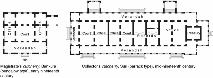
Governmental architecture in the provinces was rooted directly in residential forms and characterized by a large degree of typological non-fixity and inter-changeability. In terms of formal type, most provincial cutcherries were essentially derivatives of the ‘bungalow’ and, later, the ‘barrack’ – both of which were originally meant for residential use (Figure 12). In the provincial landscape, the bungalow, as a formal type, could equally be a house or an office, just as the barrack could equally be a collective residential unit or a collective office unit. All these paradigms operated simultaneously within the fluid and ambiguous space of provincial functioning.
Bungalow and barrack type cutcherries. Drawings: author.

In terms of lifestyle and domestic spaces, the province stood between the urban and the rural. To the British officer posted to the provinces via Calcutta, the sadar represented a move to the ‘countryside’.Footnote 46 The luxurious bungalow in the district with its vast enclosure and its retinue of service staff offered a completely different lifestyle and became the symbolic universe for country-living. Through a system of service personnel and spaces, it built up a certain ‘environmental competence’ against ‘tropical’ elements.Footnote 47 It also allowed enjoyment and apparent control of abundant land – the boundaries of which were virtually invisible – perceptually extending right into the countryside. The bungalow was typically wrapped around with a deep verandah which connected its interior space with the exterior land. The juxtaposition of the generous verandah and the vast bungalow grounds in the districts enabled a command of space, a distancing and a gaze perhaps like nowhere else. The verandah in the provincial bungalow thus became a key site of aesthetic and sensory consumption and for the experience of power. It was here that an essential, pragmatic, bodily environmental competence started to fuse into realms of leisure, pleasure, voyeurism, consumption and control. At the same time, the bungalow posed simultaneous, contradictory and opposed relationships. Thus, while the European officer wanted to enjoy its generous provisions – he was equally limited by the need to shield himself from the scorching sun, to the incumbency of the verandah to protect him from what lay outside. In an environment thick with the presence of native staff, it also resulted in the mandatory compromise of the notions of privacy that he had carried with him from home.Footnote 48
To large sections of native population moving from villages into the sadar, it represented a movement to the town, the ‘urban’ location. With this, the conceptual world which came into question was the idea of the ‘home’, tellingly revealed in the split-domesticity of the bari (the native place, usually the rural roots) and the basha (the place in the town, the urban dwelling) that came up in nineteenth-century Bengal. What is critical though is that both sites continued to constitute a composite domestic sphere spread over the village and the town. During its consolidation up to the mid-nineteenth century, the zilla sadar represented one end of a territorial split along gender between the village and the town. Save for prostitutes’ and mistresses’ quarters, it remained a predominantly male domain. In the late nineteenth to early twentieth centuries, however, families were increasingly brought into the towns, and there was, in some ways, an attempt to reclaim the completeness of familial environment within the urban milieu of the sadar. Buildings of this period, like the Shahana residence in Bankura, reflect a simultaneous attempt to articulate and expand the publicness of the outer house on the one hand, and to reclaim the familial spaces and interiority of the inner-house characteristic of village life, on the other. The Sahana residence was bought as a villa in the late nineteenth century by Satyakinkar Sahana, a mica merchant and chairman of the Bankura municipality, who in the next decade and half, undertook a series of spatial interventions to expand and articulate inner and outer domains within it (Figure 13). A baithak khana or drawing room to entertain guests, a ‘radio room’, guest rooms with attached toilets, ornamental front gardens, a portico and a road of newly negotiated geometry to receive the motor car were set out to articulate an elaborate public domain within the house. However, there were also other, more interior worlds being shaped within – through the introduction of a series of introverted and interconnected enclaves inside to house cooking areas, maternity rooms, tutorial spaces for children and storage for staples and provisions arriving from the ancestral village. In many such ways, the village found its way right into the spaces of domestic life of the sadar. Simultaneously, the outer domain in houses was being systematically rendered as an extension of the larger public domain of the town, and of the evolving urban public sphere that had become a hallmark of late nineteenth-century Calcutta. It was also characterized by collection and display of varied artefacts from across the world. Via its colonial cousins in Calcutta, the provincial domestic outer domain thus became a site for bizarre connections between apparently obscure semi-rural towns and cultural fragments from a much larger metropolitan landscape.
Inner and outer domains, Sahana residence, Bankura, late nineteenth to early twentieth centuries. Photos and drawing: author.

Conclusion
The zilla sadar, in effect, was a far more complex, heterogeneous and nuanced landscape than can be understood through such blanket categories as city, town, suburb, or in terms of binary oppositions like ‘black-town/white-town’, ‘dominant/dependent’ and ‘native/sahib’ areas. Any attempt to homogenize or unify its urban landscape was continuously subverted by the very fact that it had necessarily to assimilate complex pre-existing layers and incrementally forge a spatial culture for a diverse population. It thus operated in a fluid and amorphous space – of movement between locales and different perceptions of such moves, of inter-changeability of form and type of space, of non-fixity of occupation and use, of fluidity of spatial interpretation and conflicting readings of wholesomeness and heterogeneity. This in turn was a direct result of the zilla sadar's ‘intermediate’ nature – strung as it was between the rural–urban, centre–periphery, European–Indian and big city–small town dynamic. Its contours, right from urban form to building types and interior spaces, were determined by a range of relationships of difference, autonomy and dependence, on the one hand, with a vast rural hinterland with which its own life was intricately enmeshed, and, on the other, with large urban centres such as Calcutta which logistically and in terms of cultural trickle-down, continued to fuel the spatial imagination of the sadar.