Village formation is generally associated with multifamily residential clusters, increased sedentism, agricultural dependence, and population growth (Bandy and Fox Reference Bandy, Fox, Bandy and Fox2010). How archaeologists define a village may vary in terms of such factors as population levels (e.g., Wilshusen and Perry Reference Wilshusen, Perry, Bocquet-Appel and Bar-Yosef2008:420) or integrative mechanisms indicated by communal or monumental architecture (e.g., Byrd Reference Byrd1994). In the U.S. Southwest, however, the term “village” is often used synonymously with site, settlement, or community (Herr and Young Reference Herr, Young, Young and Herr2012:4), conflating a unit of archaeological analysis (the site) with social institutions like villages and communities and social processes like village formation that we seek to understand (see also Yaeger and Canuto Reference Yaeger, Canuto, Canuto and Yaeger2000).
Village formation has been a topic of study in the Pithouse period (AD 200–1000) in the Mogollon region of southwestern New Mexico and southeastern Arizona. Here, sites vary in size from one to over 100 pithouses. Traditionally, researchers (e.g., LeBlanc Reference LeBlanc, Cordell and Gumerman1989:180–181) suggested that sites with numerous pithouses and ceramics reflected an adaptive shift to year-round sedentism and a significant dependence on agriculture. Large Mogollon pithouse sites, therefore, were called villages. Recent research, however, suggests seasonal mobility and foraging remained important practices during the Pithouse period (e.g., Diehl Reference Diehl1996, Reference Diehl, Roth and Stokes2007, Reference Diehl, Young and Herr2012; Swanson et al. Reference Swanson, Anyon, Nelson, Young and Herr2012). Many researchers no longer assume that pithouse sites meet the criteria for a village (Anyon and Roth Reference Anyon, Roth, Roth, Gilman and Anyon2018:54), although the “village” label often remains. A major challenge in understanding the nature of these large pithouse sites is determining the contemporaneity of occupied structures (Roth and Stokes Reference Roth, Stokes, Roth and Stokes2007:2). This is especially true of Mogollon sites, prior to AD 700, because architectural styles and ceramic types are static for several centuries.
Archaeologists have reconstructed the occupational histories of large pithouse sites, such as Los Pozos in the Tucson Basin (Gregory and Diehl Reference Gregory, Diehl and Schlanger2002), but these often use indirect, relative dating methods rather than chronometric methods (see Rocek [Reference Rocek, VanPool and McCarthy2013] for an exception). Although dendrochronology has provided precise construction dates for individual structures (e.g., Smiley Reference Smiley1949), it is not widely available. This is the case in the Mogollon region, where tree-ring cutting dates prior to AD 700 are rare. Furthermore, scholars have often assumed that radiocarbon dates lack the fine-grained resolution needed to establish the contemporaneity of structures (Nelson Reference Nelson1999:74).
This article uses Bayesian chronological modeling to examine pithouse contemporaneity at a Mogollon pithouse site, arguing that the site was not a village—which implies continuous year-round occupation of multiple contemporary residences—but a persistent place that saw repeated, transient occupation by the same or different groups of people (Schlanger Reference Schlanger, Rossignol and Wandsnider1992). This shift in our understanding of a pithouse site has implications for our population estimates and explanatory models for the site and region.
Sarah Schlanger first used the term “persistent place” to describe “a place that is used repeatedly during the long-term occupation of a region” (Reference Schlanger, Rossignol and Wandsnider1992:92) as a means to connect sites and isolated finds on a landscape. She showed how natural and cultural features in southwestern Colorado shaped the ways in which prehistoric people continued to use a site for resource acquisition after it ceased to be occupied. Persistent places are defined by (1) a physical location with elements that make it suitable for certain practices or behaviors, (2) cultural features or qualities that promote reuse, and (3) the repeated occurrence of practices over long periods of time (Schlanger Reference Schlanger, Rossignol and Wandsnider1992:97). Although the persistent-place construct is applied mostly to hunter-gatherer societies (e.g., Littleton and Allen Reference Littleton and Allen2007; Moore and Thompson Reference Moore and Thompson2012), Roth (Reference Roth, Sullivan and Olszewski2016) suggests that persistent places also provide a means for developing and reinforcing community identity in more settled, agricultural societies. In all cases, the key quality of a persistent place is that it is formed through noncontinuous and repeated use and occupation of a place over a long time (Clark and Gilman Reference Clark, Gilman, Young and Herr2012:63).
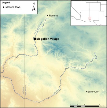
The focus of this article is the large pithouse site of Mogollon Village (LA 11568) in western New Mexico (Figure 1). I use a Bayesian chronological framework to provide more precise date estimates for the occupational history of Mogollon Village (see also Barkwill Love Reference Barkwill Love2020). As opposed to relying on radiocarbon dates alone, a Bayesian approach uses contextual information along with the chronometric data (Bayliss Reference Bayliss2009; Buck et al. Reference Buck, Kenworthy, Litton and Smith1991:881). Although interpretative, this approach provides a more precise, robust, and reproducible estimate for not only dated events but also undated events and their durations (Bayliss et al. Reference Bayliss, Ramsey, van der Plicht and Whittle2007:8–9). The objectives of this study are to (1) provide date estimates for the individual pithouses at Mogollon Village, (2) assess whether the site was a persistent place or a village, and (3) show how Bayesian analysis can improve our understanding of pithouse sites. The results confirm, supplement, or challenge existing chronologies, and by extension, our understanding of Mogollon settlement and defensive strategies and community integration. Mogollon Village is an ideal example for this study because it contains multiple excavated pit structures, an assemblage of existing chronometric dates, and no later pueblo occupation.
Location of Mogollon Village.

Background
Archaeological Investigations at Mogollon Village
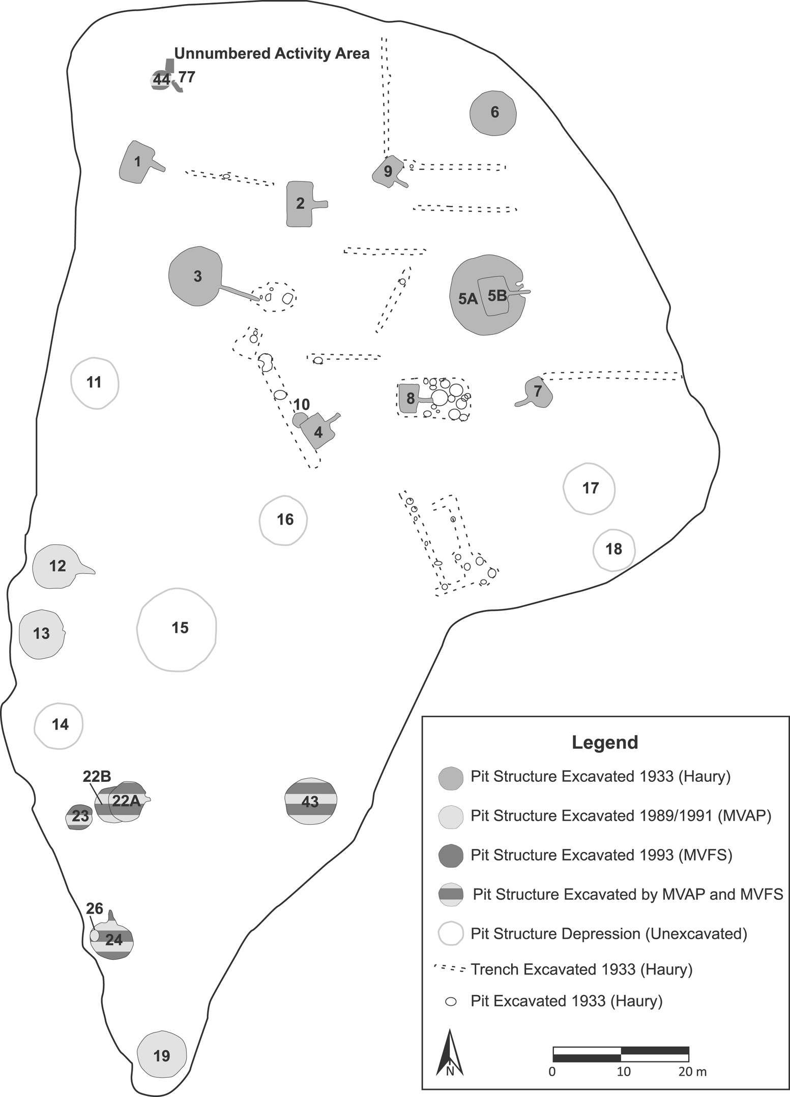
Mogollon Village is located on a mesa top overlooking the San Francisco River in west-central New Mexico within the Mogollon-Mimbres region. The site is estimated to contain roughly 50 pithouses (Figure 2). Three archaeological projects have excavated at Mogollon Village. In 1933, Emil Haury (Reference Haury1936) completely excavated 11 pithouses and numerous extramural features. Haury identified three pithouse types and placed them into two phases. The Georgetown phase was marked by round domestic pithouses, whereas the subsequent San Francisco phase had round ceremonial and rectangular domestic structures. Based on the tree-ring dates, Haury (Reference Haury1936:116) inferred that the Georgetown phase started prior to AD 800 and the San Francisco phase ended around AD 900. Pithouse placement did not appear to follow any formal plan (Haury Reference Haury1936:8). Haury's excavations helped establish Mogollon culture as something distinctly different from the Basketmaker-Pueblo (now Ancestral Pueblo) and Hohokam cultures.
Map of Mogollon Village with excavated features from the 1933, 1989, 1991, and 1993 excavations (based on Duncan et al. Reference Duncan, Gilman and Mauldin1991:Figure 3.1; Gilman et al. Reference Gilman, Mauldin and Powell1991:Figure 1.2; Haury Reference Haury1936:Figure 2; Linse Reference Linse1997:Figure 3.2).

More than 50 years later, the Mogollon Village Archaeological Project (MVAP) conducted test excavations at the site in 1989 and 1991 (Duncan et al. Reference Duncan, Gilman and Mauldin1991; Gilman et al. Reference Gilman, Mauldin and Powell1991). This collaborative effort between the University of Oklahoma, the University of New Mexico, and the USDA Forest Service sought to assess the possible erosion damage to the site, collect additional chronometric data, and test areas that had not previously been excavated. The MVAP project excavated nine pithouses, three possible pit structures, and several other features. They also re-excavated three of Haury's pithouses to obtain archaeomagnetic dates, which they succeeded in doing in one of the structures.
Excavations at Mogollon Village continued in 1993 with the Mogollon Village Field School (MVFS) sponsored by the University of Washington and the Gila National Forest (Linse Reference Linse1997, Reference Linse, Roth and Stokes2007). The primary goal of the MVFS was to define structure boundaries and morphology and obtain additional chronometric data. The MVFS continued MVAP excavations in five pit structures and excavated five new potential pit structures and several other features. Unlike Haury's project, the MVAP and MVFS only excavated a small portion of each pit structure and focused on circular pithouses.
The MVAP and MVFS projects produced 19 radiocarbon dates, 20 obsidian hydration dates, and one archaeomagnetic date to complement Haury's existing tree-ring dates (Linse Reference Linse1997, Reference Linse, Roth and Stokes2007; Mauldin et al. Reference Mauldin, Gilman and Stevenson1996). Mauldin and colleagues (Reference Mauldin, Gilman and Stevenson1996) suggested that Mogollon Village was occupied from AD 120 to 898 and possibly earlier, but perhaps not continuously, with the major occupation in the AD 700s. Furthermore, they suggested that Mogollon Village was unique among Mogollon pithouse sites because it was used during both the Early and Late Pithouse periods.
Mogollon-Mimbres Chronology
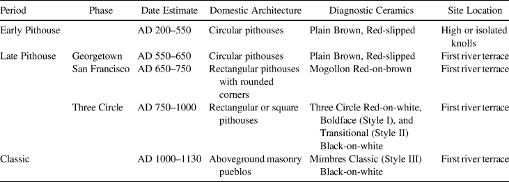
Haury's work at Mogollon Village provided the first absolute dates for defining the Mogollon-Mimbres Pithouse period (Roth et al. Reference Roth, Gilman, Anyon, Roth, Gilman and Anyon2018:8). Additional excavations in the 1970s allowed researchers to establish a full chronology for the region, summarized in Table 1 (see Anyon et al. [Reference Anyon, Gilman and LeBlanc1981] and Roth et al. [Reference Roth, Gilman, Anyon, Roth, Gilman and Anyon2018] for a full discussion of the periods/phases). Of relevance here is that researchers have suggested that a major adaptive shift occurred between the Early Pithouse period and the Georgetown phase of the Late Pithouse period (Anyon et al. Reference Anyon, Gilman and LeBlanc1981). Around AD 550, site locations moved from high ridges to first river terraces. Scholars have debated whether Early Pithouse sites were located on high ridges for defensive reasons or for facilitating social interaction (see Diehl [Reference Diehl, Diehl and LeBlanc2001:31–33] for full discussion of the debate). Regardless, the shift to alluvial terraces is inferred to reflect greater dependence on agriculture (Roth et al. Reference Roth, Gilman, Anyon, Roth, Gilman and Anyon2018:9). Several researchers have also suggested that a further increase in agricultural dependence coupled with sedentism occurred around AD 700, coincident with the appearance of a more productive maize variety (e.g., Diehl Reference Diehl1996; Swanson et al. Reference Swanson, Anyon, Nelson, Young and Herr2012). Gilman (Reference Gilman, Bandy and Fox2010), however, argues that sedentary village life did not occur until much later.
Traditional Mogollon-Mimbres Chronology.

Sources: Table adapted from Anyon and colleagues (Reference Anyon, Gilman and LeBlanc1981:Table 2) and Roth and colleagues (Reference Roth, Gilman, Anyon, Roth, Gilman and Anyon2018:Table 1.1)
Anyon and colleagues (Reference Anyon, Creel, Gilman, LeBlanc, Miller, Nash, Nelson, Putsavage, Roth, Schollmeyer, Sedig and Turnbow2017) recently refined the Mogollon-Mimbres chronology using Bayesian analysis on 1,335 absolute dates (tree ring, radiocarbon, and archaeomagnetic). This revised chronology moves the Georgetown phase into the Early Pithouse period, and it dates the Early Pithouse period to roughly AD 170–290 to AD 735 based on radiocarbon dates from short-lived plant material and construction beams. Date estimates for the individual phases of the Late Pithouse period were not provided, but the Late Pithouse period was estimated to end around AD 1010–1020. The implications of this new chronology have yet to be discussed (Roth et al. Reference Roth, Gilman, Anyon, Roth, Gilman and Anyon2018:5).
Methodology
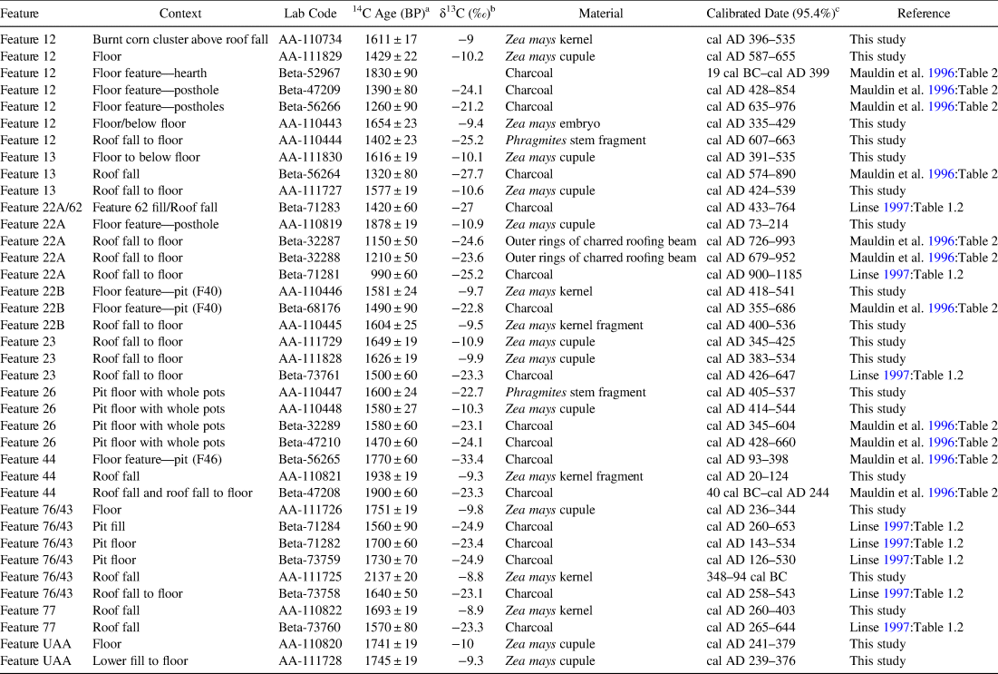
For this study, I included 19 newly analyzed AMS radiocarbon measurements on short-lived botanicals from Mogollon Village (Table 2; Barkwill Love Reference Barkwill Love2020:Table 4.2). The dataset for the models includes 38 radiocarbon dates, six tree-ring cutting dates, and one archaeomagnetic date from 14 pit structures or features (see Table 2, Supplemental Table 1, and Supplemental Text 1). I constructed the Bayesian models using OxCal 4.3.2 (Bronk Ramsey Reference Bronk Ramsey2009a) with the IntCal13 (Reimer et al. Reference Reimer, Bard, Bayliss, Beck, Blackwell, Ramsey, Buck, Cheng, Edwards, Friedrich, Grootes, Guiderson, Haflidason, Hajdas, Hatté, Heaton, Hoffmann, Hogg, Hughen, Felix Kaiser, Kromer, Manning, Niu, Reimer, Richards, Marian Scott, Southon, Staff, Turney and van der Plicht2013) calibration curve and a one-year resolution. OxCal uses a Markov chain Monte Carlo (MCMC) sampler to generate a representative sample of solutions and a range of probability outcomes (Bronk Ramsey Reference Bronk Ramsey2009a). OxCal also calculates agreement indices for the calibrated date (individual index of agreement) and the model (Amodel). For both, values above 60 indicate good agreement between the data and the model parameters (Bronk Ramsey Reference Bronk Ramsey2009a). To ensure stable model outcomes, all models were run with 20 million MCMC iterations. As mentioned above, Bayesian modeling produces interpretive estimates based on the dates and archaeological information used in the models. Consequently, these estimates can change with additional data or if the data are modeled from a different perspective.
Radiocarbon Data.

Notes: UAA = Unnumbered activity area
a All dates are conventional radiocarbon (Stuiver and Polach Reference Stuiver and Polach1977) ages that have been corrected for fractionation.
b All δ13C values are by isotope-ratio mass spectrometry (IRMS). If blank, value is not available.
c All dates have been calibrated using the IntCal13 calibration curve (Reimer et al. Reference Reimer, Bard, Bayliss, Beck, Blackwell, Ramsey, Buck, Cheng, Edwards, Friedrich, Grootes, Guiderson, Haflidason, Hajdas, Hatté, Heaton, Hoffmann, Hogg, Hughen, Felix Kaiser, Kromer, Manning, Niu, Reimer, Richards, Marian Scott, Southon, Staff, Turney and van der Plicht2013) in OxCal 4.3.2 (Bronk Ramsey Reference Bronk Ramsey2009a).
I selected the samples for new AMS dates iteratively in three successive batches. For each batch, simulation models helped me select samples from archaeological contexts that would contribute the most to refining the modeled date estimates. The goal for each batch was to select specimens that would provide dates for pithouse occupation and/or test existing dates. Establishing a direct relationship between the dated event (the specimen dated) and the target event (in this case, structure occupation; Dean Reference Dean1978:226, 228) is an important aspect of Bayesian modeling. Given the available materials, I selected specimens from contexts that could be interpreted as having a functional relationship with the structure occupation. These contexts included roof fall, floor, and floor features (e.g., floor pits, hearths, and postholes). For the existing chronometric dates, preliminary reports (Duncan et al. Reference Duncan, Gilman and Mauldin1991; Gilman et al. Reference Gilman, Mauldin and Powell1991; Linse Reference Linse1997), published monographs and papers (Haury Reference Haury1936; Linse Reference Linse, Roth and Stokes2007; Mauldin et al. Reference Mauldin, Gilman and Stevenson1996), and the original excavation forms and notes were used to assign samples to a context.
Typically, the occupation of a Mogollon pithouse site is assessed using dates from a few pithouses, each of which may only have a single radiocarbon date. This is insufficient for examining pithouse contemporaneity. Due to in-filling and other site formation processes, stratigraphy in pithouses is complicated, and a given radiocarbon date may not relate to the structure occupation. Therefore, I ensured that at least two radiocarbon samples were used from occupational contexts in each structure. To test the consistency and security of those dates, I conducted a chi-square test (Ward and Wilson Reference Ward and Wilson1978) on the dates from the same and/or related contexts. In cases where the samples failed and no evaluative information was available, the samples were initially included in the model, and the individual index of agreement was used to assess whether a result should be included or excluded as an outlier. From the initial testing and modeling, only one date was excluded (Beta-71281 from Feature 22A). The remaining 37 radiocarbon dates were included in all models. A detailed evaluation of the dates from each pit structure is discussed in Supplemental Text 1.
As with most archaeological projects, more dates are preferred. The conventional radiometric dates and the calibration curve fluctuations impacted the desired chronometric precision. Furthermore, some structures, such as Feature 77, only have two dates associated with the occupation, which is less than ideal. It is also likely that there are more pithouses at the site than those excavated or visible from surface depressions. Yet despite these limitations, the 74 available chronometric dates make Mogollon Village one of the best-dated pithouse sites in the Mogollon region. Furthermore, the multiple, statistically consistent radiocarbon dates and the tree-ring cutting dates provide a means to estimate at least the construction date for 13 of the 25 excavated pit structures, which allows for a more detailed assessment of Mogollon Village occupation. Defining the occupational histories of the individual structures will also contribute to our understanding Mogollon pithouse settlement patterns, demographic trends, and social organization.
Primary Model Construction
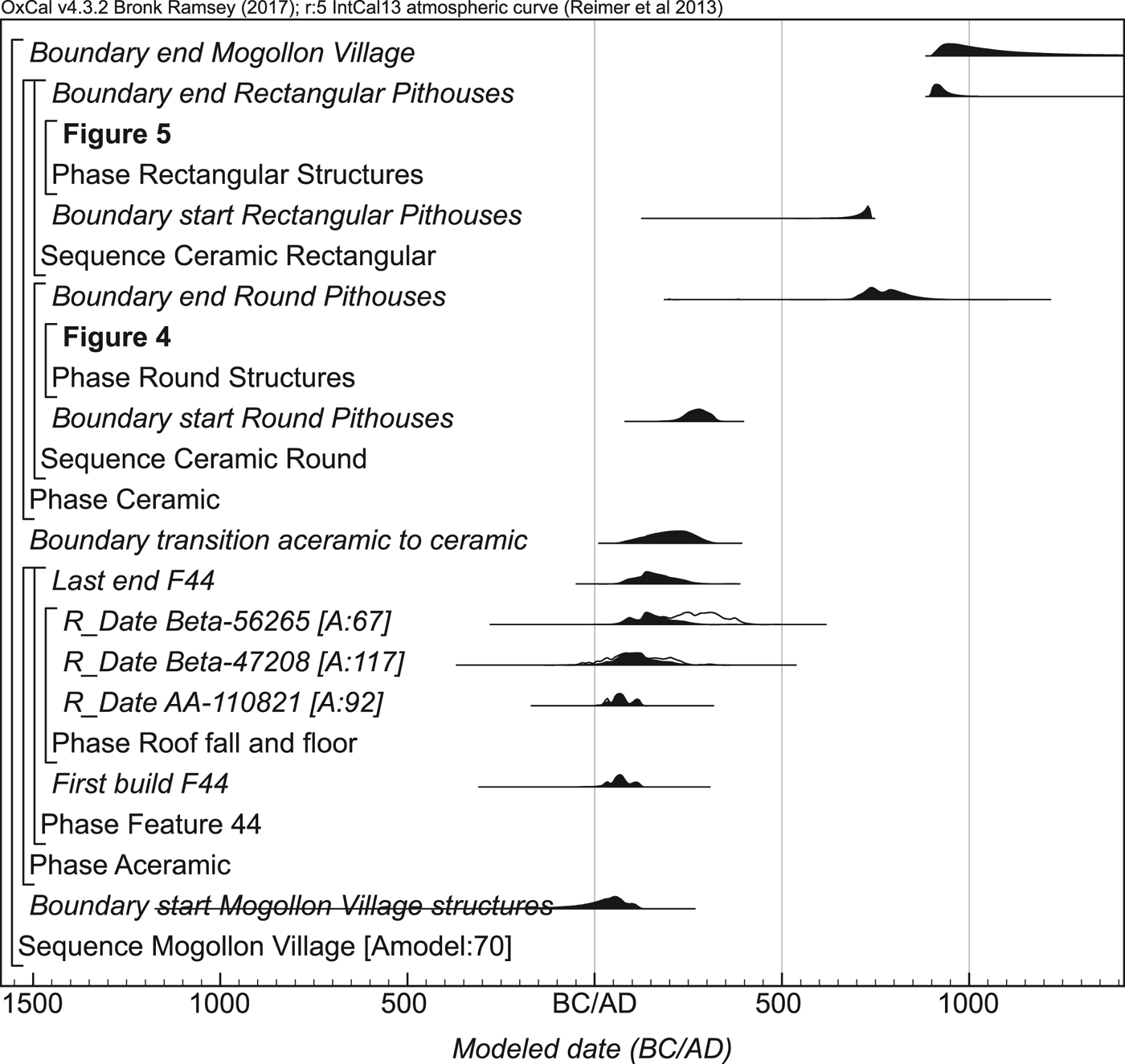
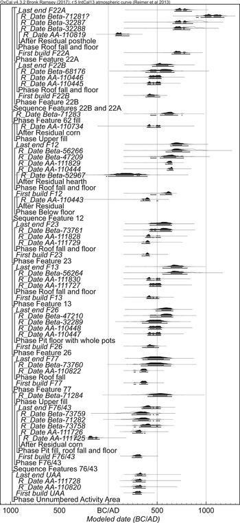
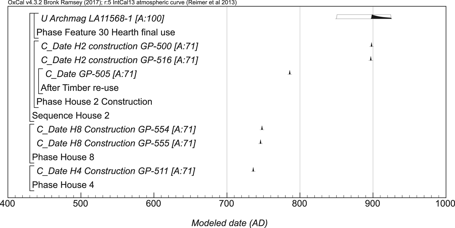
The Bayesian model (Model I) includes relative dating using architectural forms and ceramic types (see also Barkwill Love Reference Barkwill Love2020). The model consists of three components: aceramic pithouse, ceramic round pithouses, and ceramic rectangular pithouses (Supplemental Figure 1; Supplemental Text 2). The model assumes that the aceramic component predates the ceramic component and forms a contiguous phase of activity. Within the ceramic component, the model incorporates the archaeological evidence that circular-shaped pithouses were in use prior to rectangular-shaped pithouses (Anyon et al. Reference Anyon, Gilman and LeBlanc1981). However, given that the early painted ceramic type, Mogollon Red-on-brown, was found in floor contexts of the round pithouses 12 and 22A and the rectangular pithouses, the model allowed for the possibility of an overlap between the round and rectangular pithouse phases. Finally, I used a general outlier analysis (Bronk Ramsey Reference Bronk Ramsey2009b) to identify and proportionally weight any statistical outliers that might be due to a sample being out of context. With the outlier analysis, all the radiocarbon dates were given a prior outlier probability of 5%. Supplemental Text 1 presents a fuller description of Model I and details about each dated pit structure. The framework of the model can be derived exactly from the model diagrams (Figures 3–5). Model results, the posterior density estimates, are shown as calendar years, and they are presented in italics as probability ranges with endpoints rounded to the nearest five years.
Overall structure of Model I for the chronology of Mogollon Village. The component sections of this model are shown in detail in Figures 4 and 5. For all components of the model, the outline distributions are based on simple radiocarbon calibrations, and the solid distributions are based on the chronological model. The other distributions correspond to the model. For example, the distribution “First build F44” is the estimated date for the first use/construction of Feature 44 based on the radiocarbon dates. The brackets along the left-hand side of Figures 3–5 and the OxCal commands define the model exactly.

Probability distributions of dates from the round structures.

Probability distributions of dates from rectangular structures.

Results
Bayesian modeling provides a provisional occupational history for Mogollon Village. More importantly, it allows us to assess pithouse contemporaneity. The model has a good overall agreement (Amodel: 70) between the chronometric dates and the archaeological interpretations (Figures 3–5). As a sensitivity analysis, two alternative models were constructed (Supplemental Texts 1 and 2). The first alternative model (Model II) is identical to Model I but without the outlier analysis. The second alternative model (Model III) does not include the relative dating information derived from pithouse shape and ceramic types, and it groups all structures into a single continuous phase of activity. Both of the alternative models show good agreement between the chronometric dates and model assumptions. All three models produced similar posterior density estimates (Supplemental Table 3), which suggests that none of the models is “importantly wrong” (Bayliss et al. Reference Bayliss, Ramsey, van der Plicht and Whittle2007:7). Model II date estimates are nearly identical to those of Model I, suggesting that the models are not impacted by samples that were out of context. Model I is the preferred model. It is more robust because it accounts for more sources of error with the outlier analysis (Hamilton and Kenney Reference Hamilton and Kenney2015). Model I is also preferred over Model III because it provides more information about the occupational history of Mogollon Village, such as the beginning and ending of circular and rectangular structures.
Mogollon Village Occupation
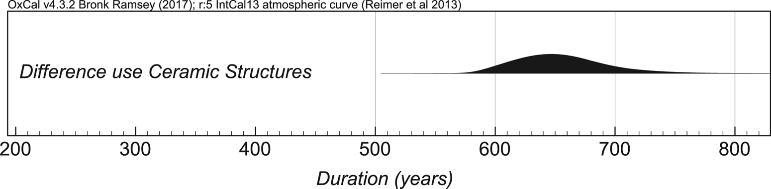
Model I supports earlier conclusions that Mogollon Village was used throughout most of the Mogollon Pithouse period (Mauldin et al. Reference Mauldin, Gilman and Stevenson1996). The modeled start date for Mogollon Village probably does not mark the beginning of occupation, given that there is only one aceramic structure. Therefore, I suggest that the latest date for the initial occupation of Mogollon Village is the estimated construction date of the aceramic structure (Feature 44) of cal AD 5–130 (95% probability; First build F44; Figure 3) and probably cal AD 25–115 (68% probability). Occupation of Mogollon Village ended in cal AD 900–1405 (95% probability; end Mogollon Village; Figure 3) and probably in cal AD 910–1120 (68% probability). The excessive tails on the occupation ending date are probably due to having only a few dates for the rectangular pithouses. Pueblo structures and Classic (Style III) Mimbres Black-on-white pottery are estimated to have been in use by AD 1000 (Anyon et al. Reference Anyon, Creel, Gilman, LeBlanc, Miller, Nash, Nelson, Putsavage, Roth, Schollmeyer, Sedig and Turnbow2017; Shafer and Brewington Reference Shafer and Brewington1995). Given that Mogollon Village had neither, a more realistic occupation ending would be to use the end of the rectangular pithouse phase estimate of cal AD 895–990 (95% probability; end Rectangular Pithouses; Figure 3) and probably of cal AD 900–940 (68% probability). Calculating the difference between the probability for end Rectangular Pithouses and start Round Pithouses provides the duration of the ceramic component. Mogollon Village ceramic component lasted for 580–740 years (95% probability; difference use Ceramic Structures; Figure 6) and probably for 605–685 years (68% probability).
Probability distribution for the duration of the ceramic component at Mogollon Village.

Earlier chronologies at Mogollon Village did not establish date estimates for the phase components. The Bayesian analysis, however, allowed for a more detailed understanding of the site's occupation by providing date estimates for the different components. Circular pithouses with ceramics and the start of ceramics began in cal AD 220–330 (95% probability; start Round Pithouses; Figure 3) and probably in cal AD 250–310 (68% probability). This estimate is in line with previous research (e.g., LeBlanc Reference LeBlanc and Schroeder1982:28–30) that suggested ceramics were introduced in the Mogollon region around AD 200. The use of circular-shaped pithouses ended in cal AD 685–880 (95% probability; end Round Pithouses; Figure 3) and probably in cal AD 710–815 (68% probability). Rectangular pithouse construction began in cal AD 635–740 (95% probability; start Rectangular Pithouses; Figure 3) and probably in cal AD 705–740 (68% probability).
With 19 new radiocarbon dates, this analysis also provides an important opportunity to evaluate the revised Mogollon-Mimbres chronological sequence (Anyon et al. Reference Anyon, Creel, Gilman, LeBlanc, Miller, Nash, Nelson, Putsavage, Roth, Schollmeyer, Sedig and Turnbow2017). The Mogollon Village Model I is consistent with the revised Early Pithouse period timeframe proposed in that sequence, which begins during the third century and ends during the eighth century, and the early AD 700s start date for the introduction of rectangular-shaped pithouses.
The long-term use of Mogollon Village is consistent with the finding that long-occupied sites in the Mogollon-Mimbres region are generally located in areas with access to both arable land and wild resources (Roth Reference Roth, Sullivan and Olszewski2016:59; Swanson et al. Reference Swanson, Anyon, Nelson, Young and Herr2012:101). Another possible explanation is that the site was important to the reproduction of social identities by allowing individuals to establish links to ancestors (Van Dyke Reference Van Dyke, Nelson and Strawhacker2011). These explanations are mutually constituted in that both practices structure the landscape in a way that encourages use and reuse and therefore support the notion that Mogollon Village was a persistent place. A key component of a persistent place, however, is that it was created by repeated uses over an extended period of time (Schlanger Reference Schlanger, Rossignol and Wandsnider1992:97) as opposed to a location, such as a village, created by continuous use. This key difference underscores the importance of determining the occupational history of the various pithouses at Mogollon Village.
Date Estimates for Individual Features (Pithouses) and Feature Contemporaneity
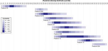
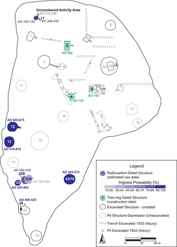
Bayesian modeling provided formal date estimates for individual pithouse use and/or construction. In the U.S. Southwest, it is generally accepted that pithouse use-life is roughly 15 years (Cameron Reference Cameron1990). Figure 7 is a schematic diagram showing the periods of use based on the first and last date estimates (see Figure 4) for pit structures with at least two radiocarbon dates from Model I. The horizontal bars represent the probability that a pit structure was in use during any given 15-year period (the darker the shading, the higher the probability) from AD 45 to AD 795. I should note that for structure 22A, the date estimates most likely represent construction, given that the radiocarbon dates are from roofing beams. Nonetheless, there is little overlap in the most probable periods of use for each structure (Figure 8).
Schematic diagram showing the periods of use of the dated circular-shaped pit structures. (Color online)

An interpretative map of Mogollon Village showing the highest probability of use (see Figure 7) or construction date for the dated pit structures, based on Model I. (Color online)

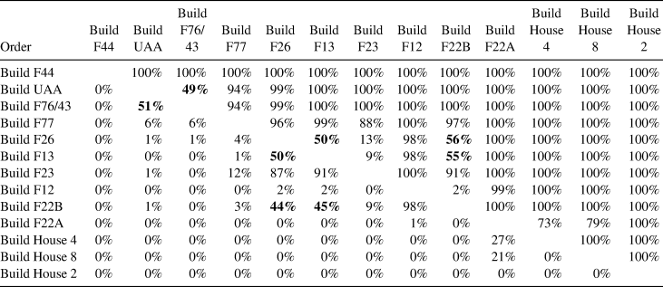
Given that some of the structures have relatively low probabilities for periods of use due to few dates and/or large date uncertainties, I also examined structure contemporaneity based on construction estimates. The estimated first dated activity for each structure, based on Model I, was used as a proxy for construction. An order matrix was created to calculate the probability that one structure was constructed before another (Table 3). The order matrix also included rectangular structure construction, based on the tree-ring cutting dates.
Order Matrix for Feature Construction.

Note: This table provides the probabilities (based on Model I) that the construction of the features in the left-hand column is earlier than the construction of the features across the top row. For example, the probabilities that Feature 44 construction (Build F44) is earlier than the construction of the unnumbered activity area (Build UAA) is 100%. Potentially contemporaneous structures are in bold.
Although most structures do not overlap in time, there are two groups of structures that could have potentially been constructed around the same time: (1) Unnumbered Activity Area (UAA) and Feature 76/43 and (2) Features 26, 13, and 22B (see Table 2). With these two groups, it is not possible to determine their relative order (see Supplemental Table 3); therefore, it is possible that they were constructed at a similar time. UAA and Feature 76/43, however, do not overlap based on the periods of use (Figure 7).
With the second group of features, it should not automatically be assumed that each pit structure represents a residential household (Wills et al. Reference Wills, Scott Worman, Dorshow and Richards-Rissetto2012:340). It is likely that Feature 22B is a domestic pithouse, whereas Feature 26 is a large pit that may have been roofed. Gilman (Reference Gilman1987) has suggested that pithouses were probably used during colder seasons, and Lightfoot and Jewett (Reference Lightfoot, Jewett, Benson and Upham1986:17) have suggested that less enclosed spaces may have been used during warmer seasons. These two structures, if contemporaneous, could have been used during different seasons, or they might have served different functions. Feature 13 is a possible communal structure (Gilman and Stone Reference Gilman and Stone2013), so it would have served a different function from that of the domestic structures. In both of these cases, more dates are needed to help resolve their possible contemporaneity, but neither represents multiple contemporaneous households.
The ceramic circular pithouse component consisted of nine dated structures. Based on the estimated construction dates, the relative order for pithouse construction/use is as follows: Unnumbered Activity Area and Feature 76/43; Feature 77; Feature 23; Features 22B, 26, and 13; Feature 12; and finally, Feature 22A. The rectangular pithouse component had only three dated structures, but these pithouses were not constructed at the same time. House 4 was probably constructed first, followed by House 8 roughly 10 years later, and then House 2 after a significant gap of roughly 150 years. Even though the sample size is small for dated rectangular-shaped structures, the temporally dispersed construction dates do not support the suggestion by Mauldin and colleagues (Reference Mauldin, Gilman and Stevenson1996) that there was a major occupation in the AD 700s. Instead, the rectangular structures appear to have been constructed in a serial fashion, much like the circular structures, which suggests continuity in the pattern of site use from the circular pithouse phase through the rectangular pithouse phase. Although it is likely that there are more pithouses than have been identified, based on dates for 13 of the 25 excavated pithouses, there were at most only a few pithouses in use at any given time. This suggests that Mogollon Village was not a continuously occupied village of several contemporaneous households. Instead, it was probably a persistent place that endured over centuries.
Discussion
Some scholars have recently argued that Mogollon pithouse sites, especially early sites, are accumulated palimpsests of small-scale occupations rather than large villages (e.g., Diehl Reference Diehl, Roth and Stokes2007; Gilman Reference Gilman, Bandy and Fox2010; Rocek Reference Rocek, VanPool and McCarthy2013). Although the question of seasonal or year-round pithouse occupation is beyond the current scope of this analysis, the more precise date estimates for the occupation of individual structures presented here support these more recent models and contrast with the view of Mogollon pithouse sites as settled villages. This has implications for our understanding of Mogollon settlement strategies, population estimates, and social organization.
In terms of settlement strategies, Mogollon Village was anomalous under the traditional Mogollon-Mimbres chronology (Anyon et al. Reference Anyon, Gilman and LeBlanc1981) because of its mesa-top location during the Early and Late Pithouse periods. The updated Mogollon-Mimbres chronology (Anyon et al. Reference Anyon, Creel, Gilman, LeBlanc, Miller, Nash, Nelson, Putsavage, Roth, Schollmeyer, Sedig and Turnbow2017) incorporates the Georgetown phase into the Early Pithouse period, which questions whether there was a major shift in settlement from high ridges to first river terraces around AD 550. Other researchers (e.g., Lekson Reference Lekson2006:37–38; Linse Reference Linse, Roth and Stokes2007:28) have also questioned this pattern. It is possible that Mogollon Village was the norm instead of an exception to the rule. If this is the case, then the placement of sites to take advantage of multiple landforms may have been a common practice throughout most of the Pithouse period. The Mogollon Village analysis suggests that more mobile lifestyles continued until at least the early AD 900s. This would imply that there was not a shift to a more sedentary lifestyle and greater dependence on agriculture around AD 550 or AD 700 as commonly proposed. The key to further evaluating these issues is to obtain more precise date estimates for multiple structures at Mogollon pithouse sites located on different landforms.
The Bayesian analysis of Mogollon Village also raises questions about demographic trends during the Pithouse period. Pithouse period population estimates have been greatly debated (LeBlanc Reference LeBlanc, Diehl and LeBlanc2001; Lekson Reference Lekson2006:59–63), ranging from very low (Gilman Reference Gilman, Bandy and Fox2010) to quite high (Anyon and LeBlanc Reference Anyon and LeBlanc1984:189), although populations are generally inferred to have increased over the course of the period. My analysis suggests that there were only a few pithouses occupied at any given time at Mogollon Village. Methods for estimating pithouse site populations are complex and debated (Anyon and LeBlanc Reference Anyon and LeBlanc1984:187–192; Wills et al. Reference Wills, Scott Worman, Dorshow and Richards-Rissetto2012), but for simple illustrative purposes, let's assume that the average pithouse had 4.5 occupants—based on the average of Anyon and LeBlanc's (Reference Anyon and LeBlanc1984:189–190) work—and that three to five pithouses were inhabited at any given time. Based on this estimate, there would be no more than 23 people at a time at Mogollon Village throughout the use of the site. With so few people, the hilltop would not confer a strategic defensive advantage, nor would there be the need for more intensive agricultural regimes as is often posited for Mogollon pithouse sites.
The Mogollon Village analysis also raises questions regarding social organization during the Pithouse period. Prior to AD 800, structures identified as communal spaces (i.e., kivas) generally lacked features or artifacts that clearly distinguished them from domestic structures, and they are identified only by their larger size (Anyon and Roth Reference Anyon, Roth, Roth, Gilman and Anyon2018:56). The function of these “extra-large” pithouses is not well understood. Researchers have suggested that they represent senior households or community integrative facilities (Diehl Reference Diehl, Roth and Stokes2007:37–38; Swanson et al. Reference Swanson, Anyon, Nelson, Young and Herr2012:108), although these need not be mutually exclusive.
I modeled two extra-large pithouses (Features 12 and 13). Although the resolution of the Pithouse 13 occupation estimate remains coarse, it was clearly constructed prior to Pithouse 12 (Table 3), and it is likely that the two structures were not in use at the same time (Figure 7). Furthermore, there were probably few other pithouses that were contemporary with these extra-large pithouses. Whether these pithouses were homes to community leaders or larger families is beyond the scope of this article. If, however, these extra-large pithouses served an integrative function, it is likely that they served a community larger than just Mogollon Village (see Gilman and Stone Reference Gilman and Stone2013), given the small population inhabiting the site at any given time. Additional chronometric estimates for pithouse sites near Mogollon Village and along the San Francisco River area are needed to better address the question of extra-large pithouse function.
Conclusion
Large Mogollon pithouse sites often are referred to and understood as “villages.” A Bayesian analysis of the chronometric data from Mogollon Village allows us to better define the site chronology, examine pithouse contemporaneity, and assess whether the site is better understood as a persistent place rather than a village.
Results suggest that the ceramic period of occupation began around cal AD 210–330, and that a change from circular to rectangular structures occurred around cal AD 630–740. The site ceased to be occupied around cal AD 885–990. Although Mogollon Village witnessed activity for at least 615–705 years, the data suggest that few structures were contemporaneously inhabited at any given time throughout site use, which suggests that the site was a persistent place (see Schlanger Reference Schlanger, Rossignol and Wandsnider1992:97). Mogollon Village's location along the San Francisco River would have provided access to arable land and wild resources, making it a favorable place for habitation. The presence of preexisting structures and, possibly, communal structures would have increased the likelihood of return for reuse: abandoned structures provide ample construction materials and a connection to the past. Finally, Mogollon Village was created through the repeated practice of use and habitation over hundreds of years. Early in the tenth century, it ceased to be a persistent place, but it is unlikely that it was ever truly “abandoned” (Nelson and Hegmon Reference Nelson and Hegmon2001).
Using relative measures, other researchers (e.g., Diehl Reference Diehl, Roth and Stokes2007; Gilman Reference Gilman, Bandy and Fox2010) have suggested that Mogollon pithouse sites probably housed only a few families at a time. The simple equation of pithouses + domesticates (maize) + ceramics = sedentary villages no longer holds for the Mogollon Pithouse period (Anyon and Roth Reference Anyon, Roth, Roth, Gilman and Anyon2018:54). As the concept of Mogollon villages is increasingly called into question, researchers are examining more nuanced questions about degrees of mobility, the nature of sedentism, and the intensification of agriculture, as well as the nature of affiliations and memories that connect people with places over centuries. A first step in addressing these issues is refining site occupational histories through chronometric means. Without knowing the contemporaneity of structures, interpretations of demographic, social, and economic issues may be severely skewed (also see Roth and Stokes Reference Roth, Stokes, Roth and Stokes2007:2).
Radiocarbon dating is often viewed as lacking the precision to examine the occupational histories of individual structures. This article demonstrates how applying a Bayesian framework to radiocarbon dates results in more precise occupational histories of sites and structures. Furthermore, it highlights how Bayesian modeling can interrogate essentializing terms such as “village.” Griffiths (Reference Griffiths2017) suggests that for Bayesian analysis to truly be revolutionary, it should allow for the creation of new narratives and not just reify our existing models. In this case, the Mogollon Village analysis raises questions regarding current understandings of the Pithouse period. With so few people at Mogollon Village at any given time, it seems unlikely that the site's location was chosen as part of a defensive strategy, that there was the need or the labor force to intensify agriculture, or that the larger structures were built to integrate the site's inhabitants. Examination of other Mogollon Pithouse sites within a Bayesian framework can further refine these issues and offer more nuanced understandings of the Mogollon region.
Acknowledgments
This project was made possible by Wendy Sutton and the National Forest Service, Gila National Forest, who granted access to the Mogollon Village archeological assemblages and gave permission for the new AMS dates. I would like to express my thanks to Patricia Gilman, Raymond Mauldin, and Angela Linse for providing me with their documentation from their excavations and answering numerous questions. I am grateful to Karen Adams, who graciously provided the plant identification for all of the dated samples. I want to acknowledge Greg Hodgins and the staff at the Arizona AMS Lab for providing training and for processing the AMS samples. I want to thank Derek Hamilton and Myles Miller for their suggestions and feedback on the Bayesian models. I also want to thank Peter Marshall for explaining how to create the periods-of-use diagram. I am grateful to Jason Yaeger for translating the abstract into Spanish. The Center for Archaeological Research provided research space and equipment for processing the flotation samples for this project. Finally, I want to thank the editor, five anonymous reviewers, my dissertation committee (Patricia Gilman, Jason Yaeger, M. Kathryn Brown, and Laura Levi), and Clinton McKenzie for their time and constructive comments on this article. Funding for this project was provided by a National Science Foundation Doctoral Dissertation Improvement Grant (BCS-1644544), an Arizona Archaeological and Historical Society Research Grant, and a UTSA Department of Anthropology Doctoral Research Small Grant.
Data Availability Statement
Artifacts, original field notes, and other documentation from the 1989, 1991, and 1993 excavations at Mogollon Village and subsequent analyses will be curated at the Arizona State Museum in Tucson, Arizona.
Supplemental Material
For supplementary material accompanying this article, visit https://doi.org/10.1017/aaq.2020.38.
Supplemental Figure 1. Schematic Diagram of Model I.
Supplemental Table 1. Tree-Ring Data.
Supplemental Table 2. Comparison of the Highest Posterior Density Estimates from the Key Parameters from Models I–III.
Supplemental Table 3. Posterior Probabilities for Relative Relationships between Contemporaneous Structures.
Supplemental Text 1. Description of Chronometric Data and Bayesian Models.
Supplemental Text 2. Code for OxCal Models.