




No CrossRef data available.
Article contents
VOLUMETRIC AND STYLISTIC REASSESSMENT OF CLASSIC MAYA SITES IN THE PETEN, RÍO BEC, CHENES, AND PUUC HILLS
Published online by Cambridge University Press: 11 July 2003
Abstract
This paper seeks to define and discuss the nature, size, variety, ideology, and change in the polities of three regions of the Maya Lowlands: the Greater Peten, Central Yucatan (Río Bec/Chenes), and the Puuc Hills. Patterned variety is demonstrable on all levels of analysis and even within stylistic regions, within suggested regional states, and within sites.
Information
- Type
- Research Article
- Information
- Copyright
- © 2003 Cambridge University Press
It is now recognized by most field archaeologists that Maya civilization was not homogeneous and that there was considerable variety among the regions of the lowlands, a zone of about 250,000 km2. However, for some students in the fields of iconography and epigraphy there is an assumption of uniformity of political organization, ideology, and iconography (e.g., Mathews 1985). Furthermore, there is a substantial group of scholars who appear to believe that the Maya were unique among Mesoamerican high cultures. They have labeled Maya polities as “theater states,” in which the ruling groups' fragile power rested on their ability to placate ritually and manipulate the supernatural (e.g., Schele and Mathews 1998; Schele and Miller 1986). Other scholars favor an interpretation that sees the leaders of Maya states as militaristic, opportunistic, exploitative, and realistic (e.g., Sharer 1994)—in short, like those of sixteenth-century central Mexico. The resultant differences in views have led to controversy over the political forms of the Classic period and the nature of the leadership class—that is, the aristocratic rulers and their supporters.
Because, as Kent Flannery has pointed out, archaeology deals essentially with circumstantial evidence, no one line of inquiry will answer the problems posed by these differing interpretations. We do not pretend to solve these enigmas in this paper. However, as a start in clarifying matters, we reevaluate and correlate evidence of different kinds from different regions. This challenges us with a difficulty in presentation because of the need to deal with differing kinds of information—in this case, site distributions and patterns, iconography in sculpture and murals, and reconstructed elite ideologies. In other words, we are dealing with quantitative and qualitative data as well as evidence on differing scales. There are also problems of citation and data that support the materials presented. In a paper of relatively short length that attempts to synthesize large amounts of material, citation of the basic sources of information is the best that can be done, considering the limitations of space, time, and the readers' patience.
We begin with indices of regional groups of sites linked together by common iconographic themes in architectural decoration. These indicate that Maya polities varied through time and space—from city-states to regional states, and from centrally organized states to some that appear to be confederations. Next we turn to an examination of the iconography of the various regions. These reflect regional differences, but mainly in emphasis within the known Maya religious patterns of polytheism and ancestor worship. There is a lack of ideological reconstruction for most regions, but one can be tentatively outlined in the Greater Peten. At this point, we change to small-scale examination of Early Classic and Late Classic tomb and art patterns of the related sites of Río Azul, Uaxactun, and Tikal. Political and military symbolism is also examined and compared with what is known from other regions. Finally, we attempt a correlation of the evidence.
We conclude with a discussion and interpretation of the patterns in the data. These inferences are that Maya civilization was indeed regionalized politically, as well as in religion, political ideology, and architecture. The patterns, in our view, reflect the operations of rulers who were acutely attuned to the realities of their world. In other words, we believe that the data indicate that the Classic Maya states were led by aristocrats whose power was based on military might and exploits, who used religious symbolism and ritual as much for propaganda as for sincere religious ends, and who built states that often reached regional sizes. Further, as has been suggested by others, the patterns indicate that Maya cultural history is a series of regional florescence rather than a single simultaneous blossoming.
THE DATA AND THEIR PATTERNS
Architectural Style Zones
These regional architectural decorative and formal styles were among the first regional aspects of culture to be defined in studies of Maya civilization. In his extensive and extraordinary surveys from 1887 to 1914, Teobert Maler was very much aware of these distinctive building styles (cf. Maler 1895). A. M. Tozzer says in a 1913 report: “From a study of the Maya remains as a whole several distinct areas can be distinguished, in each of which there is a certain kind of unity as regards assemblage, construction, and method of decoration” (1913:149). Tozzer goes on to specify Northern Yucatan, Southern Yucatan (Chenes and Río Bec), the Peten, and the Usumacinta Valley.
Many studies since Tozzer's time lead to the present conclusion that the Puuc, Central Yucatan, and Greater Peten styles are distinct in space and, to some degree, in time. Peten-style material dealt with here is from both the Early and the Late Classic periods, a.d 250–850. The Peten cultural apogees run for about seven hundred years. The central Yucatan style dates from ca. a.d 550–830 and therefore is generally contemporary with the Peten Late Classic, 650–850 (cf. Potter 1977). The Puuc building style evolves perhaps as early as a.d 500, but seems not to reach its fully developed form until about a.d 650, and lasts until about a.d 910 (Dunning 1992:66–71). All of the styles seem to undergo late florescence at about the same time—that is, during the late eighth and ninth centuries—and last about two hundred years. Arthur Demarest (1992:141) drew the same conclusion some time ago in a similar context.
Site Sizes in the Maya Lowlands
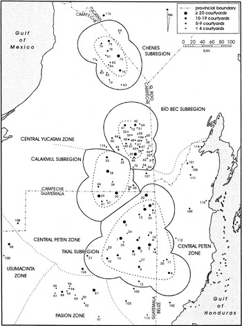
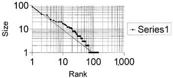
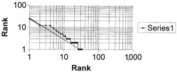
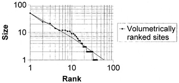
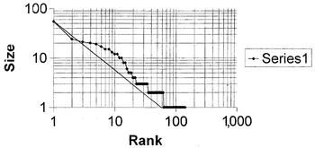
Turning to site size in these regions, enough data of roughly equivalent quality have allowed scholars to rank-order sites (Dunning 1992; Graham 1992; Morley 1938–1939; Pollock 1980; Ruppert and Denison 1943). In 1981, the geographer Richard Jones and I published a study of the Puuc, Chenes-Río Bec, and Peten region sites in which we ranked the sites according to size. We used a method called courtyard counting, although strict volumetric estimate is probably slightly more accurate (Adams and Jones 1981; Turner et al. 1981). In reality, both are assessments of the total mass of formal major architecture at Maya sites, as noted in the lengthy discussion of the methodologies in the cited papers. We also developed a map of the clusters of ranked sites in which we used a nearest-neighbor statistic based on the average day's travel time in the lowland, 37 km per day (Figure 1; Adams 1978; Adams and Jones 1981:Map 2). The patterns that result are distributional clusters of sites around three large cities: around Calakmul and Tikal in the greater Peten, and around Uxmal in the Puuc Hills. No discernible clusters appear in the Río Bec and Chenes regions unless these are combined with the sites of the Calakmul region in the latter case and with Uxmal in the former instance. We then applied the geographers' rank–size rule to the clusters of sites, with the result that we were able to suggest that the Maya of these regions at least briefly had regional states. The authors of the present paper have taken these data and much new published information into account (e.g., Dunning 1992) and reanalyzed them, with the following results (Figures 2, 3, 4, and 5).

Map of the Maya Lowlands showing rank-order and rank-size elicited sites and possible regional states of the Classic period. After Adams and Jones 1981:Figure 1; redrawn by Bruce Moses, Center for Archaeological Research, University of Texas, San Antonio.

Tikal region sites including those of the Three Rivers Zone (n = 146), rank-ordered and displayed on a double log chart. The pattern is approximately log-normal.

Río Bec region sites (n = 33), rank-ordered and displayed on a double log chart. The pattern is pluralistic.

Calakmul region sites (n = 41), including the Río Bec sites, rank-ordered and displayed on a double log chart. The form approximates a primate pattern.

Puuc Hills region sites (n = 143), rank-ordered and displayed on a double log chart. The form approximates a primate pattern.
We might have included lists of rank-ordered sites with this study. However, this would involve publication of a table of 146 sites for the Tikal region alone and of large numbers of sites from the other regions. Rather than essentially republish the data detailed in Adams and Jones, we refer the reader to sources for rank-ordered sites in the southern lowlands (Adams 1999:191–207; Adams and Jones 1981:Table 1) and in the Calakmul Region (Adams and Jones 1981:Table 1); for partially rank-ordered sites in the Puuc Hills (Dunning 1992; Pollock 1980); and for rank-ordered sites in Central Yucatan (Río Bec and Chenes) zones (Adams and Jones 1981:Table 1). The Puuc Hills sites were ranked as a total region. Data missing from the cited references are the rank-ordering of some of Pollock's Puuc Hills sites, and of the Tikal-Uaxactun region sites plotted in Dennis Puleston (1983). These evaluations and the reassessments of the already published results certainly need to be made available for the use of the few specialists interested, and we propose to do this in Ixcanrio Research Reports, Nos. 1–2 (Adams and Valdez 2002), now in press. The methodology used to produce these studies is detailed in Adams and Jones (1981) and Turner et al. (1981).
Correlations

Robert Sharer (1994:496) has criticized the “size-hierarchy” method on two grounds. First, size does not always correlate with relative political power; and second, the method is insensitive to political change. Both reproaches are faulty in that they blame the method for not compensating for the incomplete quality of the data. Skewed, incomplete, and doubtful data are an occupational hazard of archaeology, and the remedy is to produce more high-quality information, not to scuttle a promising and proven analytical tool. Some compensation for data defects may be gained by developing independent size-hierarchy data from other sources. These ranked data would include epigraphy, chronological studies, ceramic analysis, which could then be compared and correlated.
Returning to the present study, there are three possibilities with logarithmic analysis of rank-size data. One is a log-normal display, which implies politically and economically well-integrated systems of long duration. The second pattern is a plural distribution, which implies competitive centers on several levels, with none large enough to achieve dominance. The third is the primate pattern, which implies a city exponentially larger than the cities or centers below it. Primate cities are often found in the early development of a centralized state. Calakmul and Uxmal are primate cities in their regions, implying regional states and ones that had achieved their status relatively recently. The Río Bec region displays a plural pattern, which indicates that it had no one dominant center and perhaps had undergone a slow but long development. There is, however, the possibility that Calakmul at one period dominated the Río Bec region (William Folan, personal communication, 1999). Tikal is the one center that displays a log-normal pattern and therefore implies a regional state of long standing. The few data for the Early Classic 2–3 period (ca. a.d 390–530) indicate that Tikal was then a primate center for its region, again indicating a relatively recent development of the regional state.
Once established, regional building forms in all parts of the lowlands varied relatively little from early to late in their evolution. The greater Peten zone is the one for which we have the best data. Temples vary mainly from Early to Late Classic by being larger in the late period. Palace structures are more massive, more labyrinthine, and more numerous in the Late Classic. As Gordon Willey has said (unpublished comment), there is a megalomaniac aspect to Late Classic Maya buildings.
Iconographic Zones
In the greater Peten there is an Early Classic emphasis on the Storm God at Río Azul and Cerros and on the Sun God in the Late Classic (Tikal, Kohunlich). The Greater Peten is the only area in which change is readily noticeable, probably due to inadequate data on the Early Classic in all other zones. It will be noted that the change is in terms of shifts of emphasis rather than replacement of patron deities.
Buildings in the central Yucatan region commonly use Earth Monster of Sky Serpent Doorways framed by Sky Serpent stacks. These motifs occur on both palace and temple facades. The so-called “false” temple towers actually contained tombs. The distinction between palace and temple is thus blurred in the Central Yucatan region. The temple towers occur on the corners and central zones of palaces—for example, in the famous Xpuhil structure and at Becan. In fact, at Becan there is only one free-standing temple of the kind so common to the south in the Peten zone. The Chicanna palace facade is especially ornate in its decoration. The central doorway is in the form of a large Sky Serpent mouth, complete with lower jaw and teeth. This central doorway is flanked by the usual stacks of serpent masks. Two flanking doorways are decorated as if they were the entrances to thatched roof houses. The facade was once ornamented with small, three-dimensional sculptures, perhaps both humans and monkeys. This building is better studied and preserved than other examples of Central Yucatan architecture, but it seems to be typical. It faces a towered palace building across the courtyard. There appears to be no shift in iconographic emphasis during the period, and there is no reflection of the contemporary militarism. Yet nearby Becan possesses one of the largest fortification systems in the Maya Lowlands. Although built in the Late Preclassic, it was refurbished in the Late Classic, and David Webster thinks that it was open in that period (as cited in Potter 1977:7). If so, then the rejuvenation of the defensive ditch was in response to a military threat. Given that the Puuc was undergoing a militaristic expansion at the time, it is possible that the threat to Becan came from the north. Calakmul also may have constituted a threat to these apparently independent city states.
In the Puuc Hills region, the emphasis on the Earth Monster, the Sky Serpent or Itzamna, and the rain gods (Chacs) in the Late Classic is well known. Nicholas Dunning (1992:142, following Kowalski 1987) has summarized the symbolism of the Puuc facades as follows:
“A significant regional variant in eastern Puuc rulership was the emphatic identification of the ruling elite with the Chacs, or Rain Gods, manifest in the use of “Chac” in glyphic rulership titles, adornment of rulers in Chac paraphernalia in sculptural representations, and the frequent inclusions of Chac masks on elite-associated monumental architecture.”
Other Maya deities were also represented by long-nosed masks and “include Kukulcan or Quetzalcoatl (Venus as God of the Winds, manifest as a feathered serpent), and Itzamna, manifest as either the Earth Monster or Celestial Serpent” (Dunning 1992:142). Dunning (1992:150) also notes a shift in emphasis in the elite-dictated art of the late tenth century. “The monumental art of the Uxmal-Nohpat-Kabah triad and associated smaller sites … features martial subject matter. The art portrays various individuals in military regalia, scenes of warfare, or captive taking and display. This militaristic emphasis gradually supplants a regional tradition in which rulers were more often portrayed in more benign ceremonial pageantry.”
Ideology, Maya Rulership, and Regional Variation
Early Classic formal religion, worldview, and political ideology will be dealt with briefly. The following reconstruction is based mainly on data from a single site of the Maya Central Lowlands, Río Azul, and from a single period, Early Classic 2–3, dating absolutely at the site from a.d 390–530, or about 140 years. We are supplementing this reconstruction with information from the related sites of Uaxactun and Tikal.
The Importance of World Directions
East–west appear always to be the most important directions, according to Wendy Ashmore's studies (1991). Río Azul clearly reflects this significance in the layout of the total site and the orientation of nearly all of the 739 buildings to cardinal directions, as well as the strict orientation of the twenty-eight Early Classic tombs and burials in east–west directions, with three exceptions. All Early Classic temple structures faced west. The Early Classic tombs deserve more description and discussion.
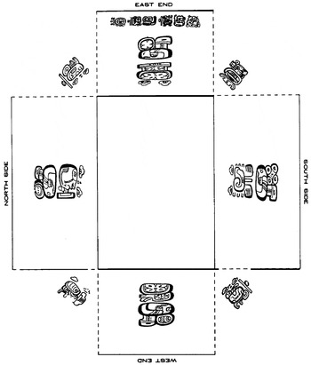
A distinctive feature of the Early Classic formal burial chambers at Río Azul is that most of them have well-preserved hieroglyphic texts and other symbols painted on their walls (Adams 1999:91–99). Tomb 12 (Figure 6) has already received considerable attention in the literature because it possesses directional glyphs painted on the appropriate walls with associated celestial signs (Adams 1999:Figures 3-15, 3-16). Tomb 1 was decorated by murals, which included a hieroglyphic text that identified the occupant as a member of the ruling family of Tikal—that is, that the deceased was a son of the Tikal ruler “Stormy Sky” and his wife “Bird Claw” and that he was born in a.d 417. His ultimate ancestry is indicated as derived from the Sun God, whose visage appears above the coat of arms of his grandfather, Curl Nose. Other tombs carry the symbol of the Storm God (Chac) and small texts that apparently identify the deceased. As noted, twenty-five of twenty-eight Early Classic tombs at Río Azul were oriented east–west. Elite male burials at Río Azul were probably oriented east–west, and elite female burials were arranged on a north–south axis. It also appears that elite burials (including those looted before 1983) at the site were overwhelmingly of males. This is plausible, given the known Maya patrilineal kinship system. Ancestor veneration, if not worship, is also indicated by these data (Hall 1984, 1986, 1987, 1988).

Mural paintings from Río Azul Tomb 12 in which the cardinal directions are indicated by giant hieroglyphs on the four walls. Glyph drawings by David Stuart and layout by Grant D. Hall.
Uaxactun
A. L. Smith (1950:88–102, Tables 6, 7) lists six tombs in his most elaborate burial category, four of which contained males considered to have been district rulers (Valdes et al. 1999:112–113) and whose tombs were oriented east–west.
Tikal tombs have not been separately reported, but William Coe's masterly report (1990) on the North Acropolis gives complete data on the largely Early Classic tombs in that building complex. Of the twenty-five burials excavated in the North Acropolis (Group 5D-2), ten can be assigned to the Early Classic (Coe 1990:Table 156; times spans 9 to 5 inclusive). Most Tikal Early Classic North Acropolis burials are those of males. Eight of the ten elaborate burials are oriented north–south. Thus, we have a striking difference between the roughly contemporary burials at the capital city of Tikal and its subordinate city of Río Azul. We suggest that differences in direction preference during the Early Classic may have something to do with differences in the patron deities of the deceased. Here also is evidence of diversity of religious practice within a regional state. Even “Stormy Sky,” ruler of Tikal, was buried in a north–south tomb (Burial 48), whereas his son, Governor X of Río Azul, was buried in an east–west tomb (Río Azul Tomb 1).
No significant burial patterns are known from the Puuc Hills sites or from the Central Yucatan sites.
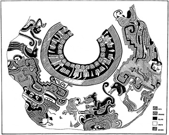
Turning to another aspect, as is well known, the ancient Maya conceived of the universe as layered into thirteen heavens and nine underworlds. Further, it appears that the underworlds were watery. For lack of space, we will deal with only one new piece of archaeological evidence here. The “Cosmos Jar” from Río Azul (Figure 7) is an Early Classic 2–3 polychrome water jar found in a courtyard of the B-56 building complex. This is a Small Palace (Class 2) residential complex (Adams 1990:25–27). The painted scene on the jar is about 95% complete. It dates from about a.d 425. The analysis of the scene has been done by Jane Jackson Adams, with advice from Jacinto Quirarte. The scene appears to represent not only the cardinal directions but also the layered universe. The core of the interpretation by Jackson Adams is that the scene probably represents activity in the afterlife. Both the celestial worlds and the underworlds are shown and are linked through the Cauac monsters. The vessel therefore appears to be a cosmic diagram in which various roles are assigned to sacred creatures. No overtly human figure can be seen, although humanity may be represented by one or more of the birds or by the composite animal. A tentative suggestion is that the birds and animals may represent totemic creatures associated with patri-clans.

The Río Azul “Cosmos” pot. Drawing by Leonel Alvarado.
To sum up, at the largest scale, major sites seem to be invariably oriented toward the cardinal directions throughout the entire Maya Lowlands, an area of 250,000 km2. This appears to reflect a uniform belief in the importance of this principle, analogous to that in traditional Chinese culture, which emphasizes geomancy in the placement of buildings. At the regional scale, there appears to be considerable diversity in elite tomb orientation, but it should be pointed out that these are always placed in reference to cardinal directions. The specific orientations—male rulers placed north–south in Tikal's North Acropolis, for example—are perhaps linked to clans' patron deities and to ancestor veneration. Uaxactun and Río Azul male rulers were buried with an east–west orientation. Could this represent differences in dynastic patron deities between capital (Tikal) and second-level administrative cities (Uaxactun and Río Azul)? At the most specific and smallest scale—that of individual depictive artifacts or art—there is again diversity, but it revolves around the interpretation of specific principles. This level of variety is reflected in items such as the Río Azul “Cosmos Jar.”
Political Ideology
The Storm God appears as patron of the earliest ruling group of Río Azul (Adams and Robichaux 1992). Tikal in the Early Classic period has clear references to the Storm God (Stormy Sky) as well as to the Central Mexican rain gods in Early Classic stelae (esp. Stela 31) and ceramics (Burial 10 pottery). On later Tikal stelae, there appears to be an emphasis on the Sun God.
The later Puuc regional rulers, as noted earlier, associated themselves with the rain gods. However, it is also clear that toward the middle of the Late Classic, predatory birds (eagles, vultures, etc.) appear as motifs on some of the buildings at Uxmal. These have been interpreted as signs of central Mexican influence, together with the possible introduction of the idea of “sacred war.” In other words, the late capital of the Puuc regional state appears to have become more militaristic through the Late Classic. This is probably also the period of the construction of the defensive wall around Uxmal and perhaps of other fortification features.
There are two bodies of iconography that reflect war and violence at Río Azul. The first is a group of Early Classic 2–3 monuments (Column Altars 1, 2, and 3), which show male humans stripped nude and evidently dying, but identified by individualized hieroglyphs on their backs. Similar Early Classic “conquered figures” were discovered by LaPorte and his associates at Tikal in the “Lost World” group. Early Classic stelae of the Greater Peten including those at Río Azul more commonly show captive figures at or under the feet of the principal humans (Robichaux 2000).
Earlier Uxmal stelae seem to link rulers to the rain gods, as noted earlier. Late Classic stelae of Uxmal, together with art from other Puuc Hills sites, depict a variety of organized violence—for example, the murals at the small site of Mul Chic and door-jamb sculpture from Kabah (Pollock 1980:Figures 372–373).
The Epigraphic Political Models
Heinrich Berlin's (1958) identification of emblem glyphs in Maya texts led Proskouriakoff to the revolutionary theory of the historicity of Maya texts, as expressed in her papers of 1960, 1961, and later. Proskouriakoff was largely concerned with deciphering the historical texts on stelae and demonstrating that the texts dealt with real temporal rulers. In the 1970s, Joyce Marcus (1973, 1976) proposed that a pattern of spatial distribution of emblem glyphs derived from a text at Copan indicated that a group of four cities or polities were associated with the cardinal directions. Further, Marcus's work established the existence of a hierarchy of sites. However, Peter Mathews, together with other epigraphers, has chosen to regard all sites identified by emblem glyphs as evidence of independent and equivalent polities (cf. Mathews 1991). This interpretation required that they ignore all variation in affixes, the enormous differences in sizes of sites and their architectural mass and paved areas, as well as big differences in the number of carved stelae. Even in 1973 this seemed an unreasonable conclusion. Some time later, Simon Martin and Nikolai Grube (1994) concluded that the epigraphic evidence supported the idea of at least some regional states, a conclusion that had been reached by field archaeologists years before. Therefore, it is now thought by many epigraphers that the textual evidence indicates variation in polity size through time and space in the Maya Lowlands. This is congruent with field archaeology studies such as the rank-order and rank-size analyses cited earlier.
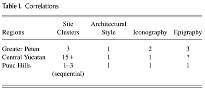
As shown in Table 1, political-unit size was considerably larger and of greater duration in the Greater Peten than in any other region. Clearly, as has been pointed out by Sharer (1991) and Marcus (1994), there were cycles—or, at least, a sequence of rises and dips—in the political and demographic history of the region. Richard Hansen's (2001) interpretation of massive amounts of data from the Mirador Basin indicate that this tradition of large-scale polities begins in the Middle and Late Preclassic periods. Architectural and iconographic styles form a unit across political boundaries in this case, with the contending states of Tikal and Calakmul sharing commonalities in these aspects. Kowalski's and Dunning's work on the Puuc Hills also indicates a series of state-level societies, but through the Classic period and building toward a very late (Terminal Classic) unified state under Uxmal (Dunning 2001).
SUMMARY AND DISCUSSION
Data considered in this paper include volumetric assessments of site sizes in three zones of architectural stylistic distinction. The three zones can be subdivided by means of rank-order and rank-size analyses. These subdivisions appear to represent a number of polities, nearly all of which date from the period a.d 650–850. Based on comparisons with other archaic civilizations and with later cultures in Mesoamerica, the characteristics of the polities appear to reflect at least three kinds of state organization. One is analogous to the Mediterranean Classic-period poleis, or city-states. This type of state in the Maya Lowlands, however, was headed by aristocratic leadership, and no evidence of democratic traditions can be found. The Río Bec-Chenes sites fall into this category. A second type is that of the large, centralized regional state, of which Tikal, Calakmul, and Uxmal are the best examples. A third type is that of the overtly militaristic centralized state that seems to have developed later at Uxmal, and at Chichen Itza (Dunning 2001).
The inappropriate nature of the segmentary-state, theater-state, and galactic-polity analogies have been pointed out by a number of scholars but most cogently by Marcus (1995:28). In her critique, Marcus notes that Aidan Southall, the originator of the “segmentary-state” concept, developed it to characterize a group of people who were actually on the chiefdom level. Southall (1991:91) later revised his characterization to note that the Alur of East Africa were not a state level society at all. Marcus further pointed out that the Maya did not have segmentary lineages, the kinship unit that was the basis for Southall's concept.
The work of Richard Fox (1977) on the nature of cities in Mesoamerica is also suspect when applied to the Lowland Maya. Although enthusiastically embraced by William Sanders and David Webster (1988), Fox's theoretical distinctions between “regal–ritual” and “administrative” cities do not hold up in the examination of the hierarchies of actual cities in the lowlands. Neither do they illuminate the real and diverse functions of middle-level cities such as Río Azul, a frontier fortress, or a lower-level town such as Colha, a center specializing in large-scale lithic production. The “garden-city” characterization of Maya cities by Gair Tourtellot (Killion et al. 1989), with significant food-production areas within the cities along with artisan quarters, seems to fit better with the facts. These scholars based their interpretation on fieldwork done within the Sayil Project in the Puuc region. Analogous garden cities have been found in China, especially in Hsia and Shang dynasty cities (Chang 1986).?pick;f8;suppress;0??pick;f8;suppress;0?
Adams and Jones's rank-size study (1981:318) posed the distinction between “chrysalis” growth and metamorphosis growth in dealing with the major cities (and regional capitals) of the three areas under consideration. The problem is one of deciding whether such giant centers are simply the small cities “writ large” (chrysalis) or distinct in quality because of their size (metamorphosis). Georg Simmel's work of the nineteenth century, and that of his modern followers in sociology, convincingly demonstrates that quantitative change leads to qualitative change, but over several thresholds (Blau 1973; Simmel 1908, 1950). We think that the patterns derived from the rank-order and rank-size analyses presented here indicate that there was a qualitative difference between capitals and the second-level administrative centers and their subordinate centers on the third and lower levels of size. We also think that the thresholds might include those defined in Dunning's ranking study (1992:89), in which the presence or absence of stelae is weighed as a factor.
Looking at change and transformation, Marcus's “dynamic model” is an excellent and probably nearly accurate reconstruction of cycles of growth of Maya polities (Marcus 1993, 1998). Dunning is also probably correct in his perception of regional and differential florescence in the Puuc (1992:156). Recent work by several projects in the Puuc and Chenes zones have produced evidence of considerable time depth in the development of the northern regional styles. However, there is a sort of delayed florescence in the north compared with those known for the south. Sharer (1991:197) has noted and graphed the rise and fall of various Maya centers. Many of these can be clearly tied to the textual record and reflect political history. For most sites, however, the textual record is imperfect or lacking altogether.
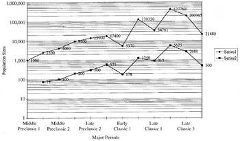
Nevertheless, archaeological field data do allow for reconstruction of population estimates through time. Regional population histories probably reflect tides of political fortune in considerable detail. At present, we have very few such studies. One regional population history has been painfully constructed over the past 15 years of work in the northeastern Peten and northwestern Belize zone. The rise and fall of political systems are reflected in the demographic history of the Three Rivers region (Figure 8). Large-scale migration is indicated by this regional population history and by Tikal data. In Early Classic times, the zone between Tikal and Lake Peten Itza was packed with people, according to the impression of William Haviland (personal communication, 1990). However, the same zone in Late Classic times had declined in population. It is noteworthy that this is the same period in which the Three Rivers region spikes in its population growth. The reasons behind the migration of large numbers of people are not clear in most cases. In the Three Rivers region, the Early Classic spike in numbers of people seems to be due to migration. Further, we can say with some confidence that those people were from other parts of the Tikal region and that they were imported to provide labor for the construction and operation of Río Azul (Adams 1999). If this interpretation is correct, then migration was clearly a result of political decisions on the part of Tikal's rulers and a partial response to their larger decision to establish Río Azul as a frontier fortress on the border with the Calakmul regional state. The Late Classic Tikal regional state did not necessarily control the Río Azul region, but uncontrolled migration may have taken place spurred by agricultural problems resulting from the onset of a series of droughts or subnormal rainfall (Brenner et al. 2002; Gill 2000; Hodell et al. 1995). Richardson Gill (2000) specifies that three devastating drought episodes followed one another, beginning, respectively, in a.d 810, 860, and 910. Hodell and his colleagues have detected an 208-year drought cycle, with one such period of water scarcity occurring around a.d 862.

A regional demographic history for the Three Rivers region. Series 1 is an inclusive population history; Series 2 is for the estimated urban (elite) residents and immediate retainers. Series 2 totals are included in the figures for Series 1.
Late Classic 2 is the time of a second large spike in regional population history; it is also the time of the sudden appearance of large numbers of aristocratic country estates. Yet the Río Azul region is one of very marginal soils (James E. Hazard, personal communication, 1984). In this context, the immense and rapid growth of population in the Puuc region also is indicated as being due partly to migration. The Terminal Classic is a period for which we have evidence of at least five major military intrusions into the Peten area by northern Maya: at Colha (Eaton 1980:145–162; Valdez 1994:14–15); Río Azul (Adams 1999:181–182, Figure 3-47); Quirigua (Sharer 1994:335); Seibal (Adams 1964, 1971:162); and Barton Ramie (Gifford 1976:289). Evidence for military encroachments from the west can be found at Altar de Sacrificios (Adams 1971:162–5); Yaxchilan (Adams 1971:163); and probably Seibal (Adams 1964, 1973; Sabloff 1975:237–239). One of several reasons for the raids from the north may have been to procure forced labor—that is, serfs to take back north. The increasingly militaristic iconography of the Puuc cities—especially that of the late capital city, Uxmal—would explain these aggressive moves against a Peten weakened by agricultural failures and all the consequent events.
RESUMEN
Este artículo presenta datos de un estudio de patrones de volumenes y estilo arquitectónicos de sitios mayas clasicos en las regiones del Petén, Río Bec, Chenes, y Puuc. Tratamos de hacer correlaciones entre la arquitectura, epigrafia, e ideología en cada region. Las implicaciones del estudio tratan de la variedad regional de la civilización maya, y las posibilidades de estructuras politicas. Un grupo de escolares han propuesto un modelo de “estados teátricos” basado en similaridades aparentes entre los mayas y las civilizaciónes de la Asia sureste. Los datos de nuestro estudio muestran que este modelo probablemente está equivocado. Hubo variedad en las estructuras estatales de los mayas, pero los más grandes estaban estados regionales, como en los casos de Tikal y Calakmul. Mas, los patrones indican, en nuestra opinión, un clase de gobernadores que mantenian sus posiciones con poder militár y alianzas políticas. Usaban simbolismo religioso e ritual tanto para propaganda como propósitos religiosos. Los datos también confirman, como ha sido sugerido antes, que la história cultural de los mayas es una série de florecencias regionales.
References
REFERENCES
Adams, Richard E.W.
1964
Seibal, Petén: una secuencia ceramica preliminar y un nuevo
mapa.
Estudios de Cultura Maya
3:
85–96.
Mexico. Reprinted in
IDAEH de Guatemala
16(2):3–12.Google Scholar
Adams, Richard E.W.
1971
The Ceramics of Altar de Sacrificios.
Papers of the Peabody Museum of Archaeology and Ethnology, Vol. 63, No. 1.
Harvard University,
Cambridge, MA.
Adams, Richard E.W.
1973
Maya Collapse: Transformation and Termination in the Ceramic
Sequence at Altar de Sacrificios. In
The Classic Maya Collapse, edited by
T.P. Culbert, pp.
133–163.
University of New Mexico Press,
Albuquerque.
Adams, Richard E.W.
1978
Routes of Communication in Mesoamerica: The Guatemalan Highlands
and the Petén. In
Mesoamerican Communication Routes and Cultural Contacts, edited by
T.A. Lee Jr. and
C. Navarrete, pp.
27–35.
New World Archaeological Foundation Paper 40.
Provo, UT.
Adams, Richard E.W.
1990
Archaeological Research at the Lowland Maya City of Rio Azul.
Latin American Antiquity
1:23–41.Google Scholar
Adams, Richard E.W.
1999
Rio Azul, an Ancient Maya City.
University of Oklahoma Press,
Norman.
Adams, Richard E.W., and
Richard C. Jones
1981
Spatial Patterns and Regional Growth among Classic Maya Cities.
American Antiquity
46:301–322.Google Scholar
Adams, Richard E.W., and
Hubert R. Robichaux
1992
Tombs of Rio Azul, Guatemala.
National Geographic Research and Exploration
8(4):412–427.Google Scholar
Adams, Richard E.W., and
Fred Valdez Jr.
2002
Ixcanrio Research Reports, Nos. 1–2.
University of Texas,
San Antonio.
Adams, Richard E.W.,
Hubert R. Robichaux,
Fred Valdez Jr., and
Jane J. Adams
2002
Comparative Regional Trends and Fluctuations in Classic Maya
Civilization.
Unpublished ms.
Ashmore, Wendy
1991
Site-Planning Principles and Concepts of Directionality among the
Ancient Maya.
Latin American Antiquity
2:199–226.Google Scholar
Berlin, Heinrich
1958
El glifo “emblema” en las inscripciones maya.
Journal de la Societé des Americanistes (n.s.)
47:111–119.Google Scholar
Blau, Peter M.
1973
A Macrosociological Theory of Social Structure.
American Journal of Sociology
83(1):26–54.Google Scholar
Brenner, Mark,
D.A. Hodell,
J. Curtis, and
M. Rosenmeier
2002
Paleoclima de la region maya: Sintesis del conocimiento basado en
registros paleolimnologicos. In
XI Encuentro: Los Investigadores de la Cultura Maya.
Universidad de Autonoma de Campeche,
Campeche.
Chang, Kwang-chih
1986
The Archaeology of Ancient China.
4th ed.
Yale University Press,
New Haven, CT.
Coe, William R.
1990
Excavations in the Great Plaza, North Terrace and North Acropolis
of Tikal 6 vols..
Tikal Report No. 14.
University Museum,
Philadelphia.
Demarest, Arthur A.
1992
Ideology in Ancient Maya Cultural Evolution: The Dynamics of
Galactic Polities. In
Ideology and Pre-Columbian Civilizations, edited by
A.A. Demarest and
G.W. Conrad, pp.
135–57.
School of American Research Press,
Santa Fe, NM.
Dunning, Nicholas P.
1992
Lords of the Hills: Ancient Maya Settlement in the Puuc Region,
Yucatan, Mexico.
Monographs in World Archaeology No. 15.
Madison,
WI.
Dunning, Nicholas P.
2001
Long Twilight or New Dawn? Transformations of Maya Civilization in
the Puuc Region. In
Maya, Divine Kings of the Rain Forest, edited by
Nikolai Grube, pp.
457–472.
Könemann,
Germany.
Eaton, Jack D.
1980
Operation 2011: Investigations within the Main Plaza of the
Monumental Center at Colha. In
The Colha Project; Second Season, 1980 Interim Report, edited by
Thomas Hester,
Jack D. Eaton, and
Harry J. Shafer, pp.
145–162.
Center for Archaeological Research. University of Texas,
San Antonio.
Fox, Richard G.
1977
Urban Anthropology: Cities in Their Cultural Settings.
Prentice-Hall,
Englewood Cliffs, NJ.
Gifford, James C.
1976
Prehistoric Pottery Analysis and the Ceramics of Barton Ramie in
the Belize Valley,
compiled by Carol A. Gifford.
Papers of the Peabody Museum of Archaeology and Ethnology Vol. 18.
Harvard University,
Cambridge, MA.
Gill, Richardson
2000
The Great Maya Droughts.
University of New Mexico Press,
Albuquerque.
Graham, Ian
1992
Corpus of Maya Hieroglyphics Inscriptions. Uxmal, Vol. 4, Pt. 4.
Peabody Museum, Harvard University,
Cambridge, MA.
Hall, Grant D.
1984
Tombs at Rio Azul. In
Rio Azul Reports, No. 1: The 1983 Final Report, edited by
R.E.W. Adams, pp.
53–61.
Center for Archaeological Research,
University of Texas, San Antonio.
Hall, Grant D.
1986
Results of Tomb Investigations at Rio Azul, Season of 1984. In
Rio Azul Reports, No. 2: The 1984 Season, edited by
R.E.W. Adams, pp.
69–110.
Center for Archaeological Research, University of Texas,
San Antonio.
Hall, Grant D.
1987
The Discovery of Tomb 23 and Results of Other Tomb Investigations
at Rio Azul, Season of 1985. In
Rio Azul Reports, No. 3: The 1985 Season, edited by
R.E.W. Adams, pp.
107–151.
University of Texas,
San Antonio.
Hall, Grant D.
1988
Realm of Death: Royal Mortuary Customs and Polity Interaction in
the Classic Maya Lowlands.
Unpublished Ph.D. thesis,
Department of Anthropology, Harvard University,
Cambridge, MA.
Hansen, Richard D.
2001
The First Cities: The Beginnings of Urbanization and State
Formation in the Maya Lowlands. In
Maya Divine Kings of the Rain Forest, edited by
Nikolai Grube, pp.
49–65.
Könemann,
Germany.
Hodell, David A.,
J.H. Curtis, and
Mark Brenner
1995
Possible Role of Climate in the Collapse of Classic Maya
Civilization.
Nature
375:391–394.Google Scholar
Killion, Thomas W.,
Jeremy A. Sabloff,
Gair Tourtellot, and
Nicholas P. Dunning
1989
Intensive Surface Collection of Residential Clusters at Terminal
Classic Sayil, Yucatan, Mexico.
Journal of Field Archaeology
18:273–294.Google Scholar
Kowalski, Jeffrey K.
1987
The House of the Governor: A Maya Palace at Uxmal, Yucatan, Mexico.
University of Oklahoma Press,
Norman.
Marcus, Joyce
1976
Emblem and State in the Classic Maya Lowlands.
Dumbarton Oaks,
Washington, DC.
Marcus, Joyce
1993
Ancient Maya Political Organization. In
Lowland Maya Civilization in the Eighth Century a.d, edited by
J.A. Sabloff and
J.S. Henderson, pp.
111–184.
Dumbarton Oaks,
Washington, DC.
Marcus, Joyce
1994
Political Fluctuations in Mesoamerica.
National Geographic Research and Exploration
8(4):392–411.Google Scholar
Marcus, Joyce
1995
Where Is Lowland Maya Archaeology Headed?
Journal of Archaeological Research
3(1):3–53.Google Scholar
Marcus, Joyce
1998
Peaks and Valleys of Ancient States: An Extension of the Dynamic
Model. In
Archaic States, edited by
Gary M. Feinman and
Joyce Marcus, pp.
59–94.
School of American Research Press,
Santa Fe, NM.
Martin, Simon, and
Nikolai Grube
1994
Classic Maya Politics Within a Mesoamerican Tradition: An
Epigraphic Model of “Hegemonic” Political Organization.
Paper presented at the Primer Seminario de las Mesas Redondas de Palenque,
Mexico.
Martin, Simon, and
Nikolai Grube
2000
Chronicle of the Maya Kings and Queens.
Thames and Hudson,
London
Mathews, Peter
1985
Maya Early Classic Monuments and Inscriptions. In
A Consideration of the Early Classic Period in the Maya Lowlands, edited by
G.R. Willey and
Peter Mathews, pp.
5–54.
Institute for Mesoamerican Studies Publication No. 10.
State University of New York,
Albany.
Mathews, Peter
1991
Classic Maya Emblem Glyphs. In
Classic Maya Political History, edited by
T. Patrick Culbert, pp.
19–29.
Cambridge University Press,
New York.
Morley, Sylvanus G.
1937–1938
The Inscriptions of Peten.
Publication No. 437.
Carnegie Institution of Washington,
Washington, DC.
Pollock, Harry E.D.
1980
The Puuc, an Architectural Survey of the Hill Country of Yucatan
and Northern Campeche, Mexico.
Papers of the Peabody Museum of Archaeology and Ethnology Vol. 19.
Harvard University,
Cambridge, MA.
Potter, David F.
1977
Maya Architecture of the Central Yucatan Peninsula, Mexico.
Middle American Research Institute Publication No. 44.
Tulane University,
New Orleans.
Proskouriakoff, Tatiana
1960
Historical Implications of a Pattern of Dates at Piedras Negras,
Guatemala.
American Antiquity
25:454–475.Google Scholar
Puleston, Dennis E.
1983
The Settlement Survey of Tikal.
Tikal Report No.13. University Museum.
University of Pennsylvania,
Philadelphia.
Robichaux, Hubert R.
2000
The Stelae of Rio Azul. In
Rio Azul Reports, No. 5. The 1987 Season, edited by
R.E.W. Adams, pp.
35–53.
University of Texas,
San Antonio.
Ruppert, Karl, and
John H. Denison_Jr.
1943
Archaeological Reconnaissance in Campeche, Ouintana Roo, and
Petén.
Carnegie Institution of Washington Publication No. 543.
Carnegie Institution,
Washington, DC.
Sabloff, J.A.
1975
Excavations at Seibal, Department of Petén, Guatemala;
Ceramics.
Memoirs of the Peabody Museum of Archaeology and Ethnology Vol. 13, No. 2.
Harvard University,
Cambridge, MA.
Sanders, William T., and
David Webster
1988
The Mesoamerican Urban Tradition.
American Anthropologist
90:521–546.Google Scholar
Schele, Linda, and
Peter Mathews.
1998
The Code of Kings.
Touchstone Books,
New York.
Schele, Linda, and
Mary Ellen Miller
1986
The Blood of Kings.
George Braziller,
New York.
Sharer, Robert J.
1991
Diversity and Continuity in Maya Civilization: Quirigua as a Case
Study. In
Classic Maya Political History, edited by
T. Patrick Culbert, pp.
180–198.
Cambridge University Press,
Cambridge.
Sharer, Robert J.
1994
The Ancient Maya.
5th ed.
Stanford University Press,
Palo Alto, CA.
Simmel, Georg
1908
Soziologie.
Duncker and Humbolt,
Leipzig.
Simmel, Georg
1950
The Sociology of Georg Simmel.
Translated and edited by K. Wolff.
Free Press,
New York.
Smith, A. Ledyard
1950
Uaxactun, Guatemala: Excavations of 1931–1937.
Publication No. 588.
Carnegie Institution of Washington,
Washington, DC.
Southall, Aidan W.
1991
The Segmental State: From the Imaginary to the Material Means of
Production. In
Early State Economics, edited by
H. Claessen and
P. van de Velde, pp.
25–96.
Transaction Publishers.
New Brunswick,
NJ.
Tozzer, A.M.
1913
A Preliminary Study of the Prehistoric Ruins of Nakum, Guatemala.
Papers of the Peabody Museum of Archaeology and Ethnology Vol. 5, No. 3.
Harvard University,
Cambridge, MA.
Turner, E.S.,
N.I. Turner, and
R.E.W. Adams
1981
Volumetric Assessment, Rank Ordering, and Maya Civic Centers. In
Lowland Maya Settlement Patterns, edited by
Wendy Ashmore, pp.
71–88.
University of New Mexico Press,
Albuquerque.
Valdes, Juan Antonio,
Federico Fahsen, and
Hector L. Escobedo
1999
Reyes, tumbas y palacios; La história dinástica de
Uaxactun.
Centro de Estudios Mayas, Cuaderno 25. Instituto de Investigaciones
Filológicas, Universidad Nacional Autónoma de
México e Instituto de Antropología e História de
Guatemala,
Mexico.
Valdez, Fred, Jr.
1994
The Colha Ceramic Complexes. In
Continuing Archaeology of Colha, Belize, edited by
Thomas R. Hester,
Harry J. Shafer, and
Jack D. Eaton, pp.
9–15.
Texas Archaeological Research Laboratory.
University of Texas, San Antonio.
Map of the Maya Lowlands showing rank-order and rank-size elicited sites and possible regional states of the Classic period. After Adams and Jones 1981:Figure 1; redrawn by Bruce Moses, Center for Archaeological Research, University of Texas, San Antonio.
Tikal region sites including those of the Three Rivers Zone (n = 146), rank-ordered and displayed on a double log chart. The pattern is approximately log-normal.
Río Bec region sites (n = 33), rank-ordered and displayed on a double log chart. The pattern is pluralistic.
Calakmul region sites (n = 41), including the Río Bec sites, rank-ordered and displayed on a double log chart. The form approximates a primate pattern.
Puuc Hills region sites (n = 143), rank-ordered and displayed on a double log chart. The form approximates a primate pattern.
Correlations
Mural paintings from Río Azul Tomb 12 in which the cardinal directions are indicated by giant hieroglyphs on the four walls. Glyph drawings by David Stuart and layout by Grant D. Hall.
The Río Azul “Cosmos” pot. Drawing by Leonel Alvarado.
A regional demographic history for the Three Rivers region. Series 1 is an inclusive population history; Series 2 is for the estimated urban (elite) residents and immediate retainers. Series 2 totals are included in the figures for Series 1.
 You have
Access
- 9
- Cited by