

Introduction
Water control is close to the centre of Chinese economic and environmental history.Footnote 1 Indeed, the great rivers and dense populations of East and South Asia present a series of problems beyond those experienced in Europe or many other areas of the world.Footnote 2 In no society—in China or elsewhere—however, are water control policies merely a technical matter of how to control water flows; rather they always contain a strong political element. Historians of India have shown how the British colonial regime introduced systems of water control tailored to its own interests in maintaining its dominion and promoting private property.Footnote 3 The rich sources for imperial China allow us unparalleled insight into how, long before the impact of Western imperialism, the Chinese state chose between different political priorities, and the record clearly shows that the welfare of the people was far from the top of the list of those priorities.
Many studies have explored the links between China's water control systems and its economy and society. In the 1930s, Karl Wittfogel used Max Weber's theory on the influence of bureaucracy and Karl Marx's model of base and superstructure to analyse the impact of water control on China's politics and economics.Footnote 4 Ji Chaoding (Chi Ch'ao-ting) also argued that water control projects in China were closely linked with politics because they were generally built as public works: ‘The objectives and the development of such public works were decided primarily not by humanitarian considerations but by natural and historical conditions, and the political objectives of the ruling classes.’Footnote 5 In Ji's view, at different times and under different circumstances, water control projects could either benefit or damage local economies. Later, Wittfogel argued even more ambitiously that the origins of Chinese despotism lay in the needs of hydraulic management.Footnote 6 Indeed, in David Pietz's words, most Western scholars have ‘equated the nature of the Chinese political system with the imperatives of maintaining the waterways of China’.Footnote 7
Water control works in China have fulfilled a number of functions. Ch'ang-tu Hu focused on their role in preventing floods and promoting agriculture through irrigation, arguing: ‘Since the economy of China was based on intensive farming, regulation of water, either for the positive purpose of irrigation or the negative purpose of flood prevention, remained throughout Chinese history a matter of utmost importance and a principal concern of the state.’Footnote 8 More recently, Peter Perdue examined the transformation of the social ecology of Hunan province between 1550 and 1850, a period marked by significant population growth, extension of the market, and increased agricultural productivity. He outlined the relationship between agricultural production in the region and state policies towards taxation, land clearance, dike-building, property rights, and agriculture.Footnote 9 In contrast, however, especially in some areas of North China during the later empires, the two functions of flood prevention and agricultural development were overshadowed by the necessity of maintaining the transport links that shipped grain from the Yangzi valley to the capital. In particular, during the Ming (1368–1644) and Qing (1644–1911) dynasties, the Grand Canal had to cross the Yellow River, creating some of the most intractable problems for water control, and leading to the conflicts of interest analysed in this paper.Footnote 10
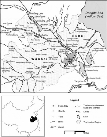
Building on these earlier works, this paper explores how the water-control policies of authoritarian central governments jeopardized economic and social conditions in a particular region—Huaibei. Roughly covering the area between the Huai River and the Yellow River and to the immediate north and south of these two rivers (see Figure 1),Footnote 11 Huaibei was one of the poorest, most disaster-prone, and most violent areas of the eastern part of China in both late imperial and modern times.Footnote 12 From the late Ming to the Republican periods, social and economic conditions in Huaibei continued to worsen. In contrast to Zhili (Hebei), which was close to the capital and of key interest to the late imperial state and therefore the beneficiary of the allocation of substantial resources for disaster relief,Footnote 13 this paper deals with an area that was intentionally abandoned as of little importance and left to go to ruin.Footnote 14
Map of the Huaibei region.
Source: ‘CHGIS, Version 4’, Cambridge: Harvard Yenching Institute, January 2007.

A number of reasons have been given for Huaibei's poverty and decline. Kenneth Pomeranz attributes it to the Qing government's abandonment of the Grand Canal under pressure from imperialism.Footnote 15 Emily Honig likewise stresses the impact of the abandonment of the Grand Canal and the mid-nineteenth century shift in the course of the Yellow River.Footnote 16 Ji Chaoding and Elizabeth Perry both point to the numerous wars that wracked the area over many centuries.Footnote 17 This paper will argue, however, that one of the key causes of the region's problems was the water control policies of the Ming and Qing governments, under which the political priorities of the state—expressed in terms of the ‘general interest’ (daju)—explicitly outweighed the ‘local’ or ‘partial’ (jubu) interests of the population of Huaibei. In other words, at times when local interests conflicted with the general interest (as perceived by the Ming and Qing states), the central governments rejected local concerns in order to preserve their key interests.
The next section of the paper will examine the priorities of the Ming and Qing states in their management of water control in the Huai region, often using the words of the senior officials involved. Following that, the paper analyses the extensive flooding resulting from those priorities and the consequent damage to agricultural production and the people's livelihoods. Finally, the paper examines how these water control policies contributed to the long-term economic decline of the region and to deleterious changes in local society.
Policies of the Ming and Qing states towards water control and the Grand Canal
The origins of Huaibei's water control problems lay in the shift of the course of the Yellow River to run south of the Shandong peninsula. This shift began from 1128, when the banks of the river were breached so that its course partly intruded south into that of the Huai River, dividing into two channels to the north and south.Footnote 18 At this time, Huaibei remained relatively unaffected because until the mid-Ming period only about 30 per cent of the flow of the Yellow River took the southern course into the Huai.Footnote 19 In the late-fifteenth century, however, officials feared that breaches of the banks of the northern channel would pose a threat to the Grand Canal. According to Liu Daxia, a leading river management official, ‘We must divert the river to the south and bypass Xuzhou and Pizhou. . . so as to secure the Grand Canal.’Footnote 20 In 1495, Liu therefore presided over the completion of a solid northern embankment on the Yellow River (the Taihang levee) in order to force the entire flow of the river south into the course of the Huai.Footnote 21 Thus the whole of the flow was diverted to the southern channel. As a result of this action, the potential flooding caused by the silt coming down the Yellow River shifted to the Huaibei region, and floods soon occurred there.
In response to the threat of flooding, the Ming state had two main priorities—protecting the cenotaph of the founding emperor's ancestors and ensuring that the Grand Canal was clear for the transport of tribute grain. Both the livelihoods and the lives of people in Huaibei were seen as minor affairs, which could be sacrificed for other interests whenever it was deemed necessary.
The imperial cenotaph was situated only a few miles from the capital of Sizhou Subprefecture.Footnote 22 Within it were buried the clothing and caps of the deceased grandfather, great-grandfather, and great-great-grandfather of the dynastic founder, Zhu Yuanzhang, and as such it had become one of the most significant sites of political pilgrimage during the dynasty.Footnote 23 A memorial to the throne from the Ministry of Works stated, ‘The Sizhou cenotaph has been the fundamental centre of state power, as both potential rulers and the lifeline of the dynasty are gathered there. And it will be the basis of claims to the throne from the sons and grandsons of emperors for eternities to come.’Footnote 24 Because of its supreme importance to the dynasty, preventing any floods from damaging the fengshui (geomantic surroundings) of the imperial cenotaph was a key political priority from the establishment of the dynasty, and a major consideration for water control in the Huai and Yellow river basins. Pan Jixun, the most renowned expert on water conservancy in Chinese history, wrote: ‘The mausoleum of the three ancestors is the origin of our dynasty and the source of all happy auspices. It is of vital importance.’Footnote 25 A memorial by Zhang Zhenguan, a high official in charge of river regulation, clearly showed the priorities of water control in the late Ming era: ‘The cenotaph of the dynastic ancestors has always been a higher priority than either the Grand Canal or the people's livelihood.’Footnote 26 Another memorial from the Ministry of Works stated, ‘[Protecting] the cenotaph from flooding is our first priority, the next is the safety of the Grand Canal, and only then the people's livelihood.’Footnote 27
The second key consideration was the operation of the Grand Canal. Northern China, especially the region around Beijing, produced insufficient grain to supply food for the residents of the capital. During the Ming and Qing periods, therefore, imperial control of the grain resources of the lower Yangzi was considered essential, both to the defence of the northern frontier and to the internal economic and political stability of the empire.Footnote 28 One high official of the Ming said: ‘The lifeline of the state is dependent upon the transport of tribute grain.’Footnote 29 Ray Huang argued that the Grand Canal constituted this lifeline. In addition to approximately 200,000–300,000 tons of tribute grain, a variety of goods produced in southern China were shipped to Beijing along the canal.Footnote 30 As Matteo Ricci wrote, because of transport via the canal, ‘Although Beijing does not produce anything, it lacks nothing.’Footnote 31
A series of statements and memorials by senior officials in charge of water control throughout the Ming dynasty make the state's priorities clear, and show the lack of concern for the people's livelihoods. For example, Wan Gong, director-general of river conservancy in the early 1570s, opposed efforts to build up the south levee of the Yellow River aimed at reducing flooding in Huaibei. In his words:
There have been some suggestions recently that we should consolidate the south levee of the Yellow River, which would force the water to the north. If we implemented this, however, it would cause breaches of the north levee at Tongwaxiang, which would endanger the Grand Canal. . . If the south levee is breached, however, the loss is merely one season's harvest.Footnote 32
He also stated that ‘breaches of the south levee of the Yellow River would be fortunate for the state (because they would not affect the Grand Canal)’,Footnote 33 and repeatedly emphasized the necessity of forcing the Yellow River to flow south:
It would be a simple matter to eliminate flooding in the areas to the south of the Yellow River if we did not consider the safety of the canal. If we allowed breaches in the north levee at Tongwaxiang in Henan province, then we could entirely prevent flooding to the south, especially in Xuzhou and Pizhou. But for the safety of the canal, we must cause the Yellow River to be breached at the south levee.Footnote 34
In fact, 280 years later, in 1855, the Yellow River changed course again precisely after a breach of the north levee at Tongwaxiang. This directed the river into its present course, to which it has kept for over 150 years.
During the Wanli period (1573–1619), Yang Yikui took charge of water regulation and began to plan a project to turn the whole of Dangshan County into a flood retention area for the Yellow River. In his words:
If we clear the land in Dangshan and allow the water to flow without hindrance, then we need do nothing further to control the water. Even though the central government will lose hundreds of taels because it has to exempt the county from taxes, it will save tens of thousands of taels.Footnote 35
In short, Yang's primary concern was government revenue, over and above the lives and property of the people. The project he eventually presided over, which involved dredging the Yellow River from Taoyuan to the sea through Andong County, did reduce the threat to the imperial cenotaph but it also exposed several counties to serious flooding. The project was later condemned as ‘a gigantic catastrophe in the history of the Huaibei water conservancy’.Footnote 36
Li Hualong succeeded Yang in both position and practice. He advised the central government to monitor the Taihang levee in the north and the Sui levee in the south, and stated that it was unnecessary to take into consideration the lives and property of people who lived between these levees, including those in Xiao, Dangshan, Feng, and Pei counties. He explained, ‘If the Yellow River is allowed to flow freely between the two levees, we could save large amounts of money.’Footnote 37
The most influential official with regard to water regulation in Huaibei was Pan Jixun.Footnote 38 Pan followed the instructions of the Jiajing (1522–1566) and Longqing (1567–1572) emperors from the time he was appointed director-general of river conservancy in 1565, and stressed, ‘The north levee of the Yellow River is more important than the south.’Footnote 39 In 1578, when the Wanli emperor reappointed Pan to the same position, the emperor was still worried about the possibility of breaches in the northern dike.Footnote 40 In 1579, Pan oversaw the completion of the Gaojiayan Dike, which was the main factor behind the formation of the Hongze Lake. The purpose of the project was to ‘store the clean water of the Huai River in order to scour the silt from the Yellow River’.Footnote 41 Pan's strategies of water regulation have been universally praised by Chinese scholars for centuries,Footnote 42 and indeed he did succeed in flushing out silt to a much greater extent, as is shown by the more rapid expansion of the Yellow River delta after the construction of the dike.Footnote 43
Throughout the Wanli period, the emperor and his top officials declined to take responsibility for sustaining the livelihoods of the people affected by policies introduced to protect the imperial cenotaph and the canal. In 1604 Hou Qingyuan, a Ming dynasty official with an interest in water conservancy issues, sent a memorial to the throne, stating:
After the completion of the Jiahe Canal [an important section of the Grand Canal in the late Ming dynasty], we can take a gradual approach to water conservation projects. If both the imperial cenotaph and the Grand Canal remain unaffected, we do not need to worry about where the Yellow River flows.Footnote 44
After the establishment of the Qing dynasty, the state was no longer concerned with protecting the Ming imperial cenotaph. Priorities concerning water control shifted and, in rhetoric at least, the Qing state paid more attention to the welfare of the people than did their Ming predecessors. From the Kangxi reign (1662–1722) onwards, in the interest of political stability, Qing leaders claimed to give priority to dealing with the floods that had long devastated people's livelihoods.Footnote 45 However, in practice they put the issue of tribute grain—and thus the Grand Canal—first, and that of raising revenue from the salt tax second, ahead of the people's livelihoods.
The central government considered the security of the Grand Canal to be its foremost consideration. As Zhang Baixing, director-general of river conservancy in the early eighteenth century, stated, ‘The most important concern of the state is the transport of tribute grain.’Footnote 46 Leading Qing officials such as Jin Fu, a renowned administrator and expert in water regulation in the late-seventeenth century, knew that the cause of the flooding in Huaibei was the redirection of the Yellow River into the course of the Huai.Footnote 47 In fact, Jin Fu actually converted Shuyang County and Haizhou Subprefecture into flood retention areas for the Yellow River.Footnote 48 On the whole, the Qing's policies that were developed to protect the canal, like those of the Ming, often caused floods in the eastern areas of Xuzhou Prefecture, including counties such as Andong, Haizhou, Shuyang, and Pi. An early twentieth century observer concluded that the diversion of the Yellow River into the Huaibei region had not only sacrificed the interests of that region but had harmed the broader interests of the state in maximizing revenue.Footnote 49
The second consideration was the impact of water conservancy on the large revenues coming from the salt tax in the Lianghuai salt region. As the Shunzhi emperor (1644–1661) stated in an edict, ‘Work on the dikes of the Yellow and Huai rivers affects the local salt taxes.’Footnote 50 Similarly, Jin Fu wrote, ‘For the last ten years or so, we have lost several hundred thousand taels a year from the salt tax because of flooding in areas such as Shanyang and Gaoyou.’Footnote 51
Imperial water control policies and flooding in Huaibei
These water control policies, which prioritized transport along the Grand Canal and (during the Ming dynasty) the protection of the ancestral cenotaph of the imperial family, had disastrous effects on the ecology of the Huaibei region. Many of the problems were centred around the Hongze Lake, which was created by the Gaojiayan Dike. By 1855 this lake had increased in size to an area of over 3,000 square kilometres, was one of the five largest freshwater lakes in China, and submerged large sections of farmland in Wanbei and Subei, including the famous city of Sizhou.Footnote 52 Its most detrimental feature was that it was created on the plains, a locale completely unsuitable for the construction and expansion of a large reservoir.
In the fifteenth century, before the formation of the lake, there were only four recorded instances of flooding in the middle Huai River basin. However, between the sixteenth and nineteenth centuries, after the construction of the Gaojiayan Dike, this number rose to 106, an average of 26.5 instances per century.Footnote 53 Keeping the Grand Canal unobstructed during the peak periods for the transport of tribute grain—from the fifth to the ninth lunar months (approximately June to October)—was one of the state's key priorities and required the water in the canal to be kept at a certain level. Therefore the sluices of the Hongze Lake and the Grand Canal were generally kept closed during this period in order to build up a supply of water to maintain levels in the canal. Between June and August of each year around 65 per cent of the water flow of the Huai River was directed into the lake.Footnote 54 The lake's water level rose rapidly, turning the upper reaches of Huai River into a flood retention area. This period, however, coincided with the main growing season for the local farmers, and there were large crop losses when farmland in Wanbei was submerged by severe flooding.Footnote 55
After the completion of the annual grain shipment (or whenever the water level of the lake or of the canal exceeded a certain point), the sluices were opened to reduce pressure on the embankments. This converted Subei, the region to the east of the canal, into an endemic flood area.Footnote 56 In this region, the floods interfered with the harvest season and frequently destroyed the harvests. Shen Baozhen, governor-general of Liangjiang (Jiangsu, Jiangxi, and Anhui) in the late-nineteenth century, wrote:
Conflicts of interest between civilian farmland and the canal are irreconcilable. After a dozen days without rain, the farmers desire to open the sluices for irrigation, but the officials close them in order to maintain the water level for passing ships. When the canal overflows, the officials open the sluices and dams in order to protect the embankments, thereby turning the peasants’ farmlands into one huge lake.Footnote 57
These priorities were enforced from the very top of the system. Throughout the period when the tribute grain was transported via the canal, the emperor required officials to provide him with information regarding water levels in the canal and the lake.Footnote 58 As soon as the water level exceeded a certain point, even if local officials did not wish to release excess water by opening the embankment sluices of the canal and the lake, failure to do so would probably have made them targets for imperial criticism. Thus, they were forced to induce flooding of peasant lands in order to protect their careers.
In the summer of 1826 the water level of the Hongze Lake rose rapidly. On 30 July, Qishan, governor-general of Liangjiang, opened the dikes of the lake and five sluices in the canal embankments.Footnote 59 Tao Shu, governor of Jiangsu Province, described this government-induced flood in a memorial he sent on 2 August:
All the farmlands and houses in Gaoyou, Baoying, Huaian and other subprefectures and counties have turned into a huge lagoon. . . the depth of water covering the farmland is from one and a half to over three metres, and all tombs and houses are submerged. . . The people are helping infants and the elderly move to higher ground.Footnote 60
A poem entitled ‘Dike Opening’ confirms this: ‘Just before harvest, the five dikes were opened. . . thousands of families were crying and screaming amidst the flood.’Footnote 61
In spite of this disaster befalling the peasants, both the emperor and senior officials were still primarily concerned with ensuring the transportation of tribute grain; few officials worried for the people's lives. On 3 August, an edict of the Daoguang emperor (1821–1850) to the senior officials in Liangjiang stated:
All tribute ships must return on time, and loaded ships must be secured to run as usual through the canal next year. Since your subordinates with responsibility for river management believe that opening the dikes is the most feasible policy, you must insist on this course of action. . . If next year's grain shipments are delayed, the punishments will be severe.Footnote 62
The problem of flooding increased over time. The strategy of storing clean water from the Huai River in the Hongze Lake in order to scour out the Yellow River's silt required officials to enhance and solidify the Gaojiayan Dike.Footnote 63 Since the bed of the Yellow River rose constantly,Footnote 64 they were forced to raise the water level of the lake, thus steadily increasing the amount of land around the lake vulnerable to flooding.Footnote 65 In addition, much of the water from the tributaries of the Huai River could not flow down the primary channel because of obstruction by the high water levels in the Hongze Lake. In the early to mid-eighteenth century the overflow at the intersection of the main channel and its tributaries developed into dozens of large lakes in low-lying areas of Wanbei.Footnote 66 Seventeen large lakes formed between the Hongze Lake and the canal's western bank. And, owing to the regular release of water from the canal, 36 large lakes formed in Subei to the east.Footnote 67 All these lakes submerged what had previously been prosperous farmland or thriving towns.Footnote 68
The northern part of Subei, which was less affected by the Hongze Lake, and the southwestern sections of Shandong, through which the Grand Canal passed, also suffered from serious disasters induced by government actions. After the Jiahe Canal was completed in 1604, the four lakes of Weishan, Zhaoyang, Dushan, and Nanyang (generally called the Weishan lakes) were made into a supply reservoir for the Grand Canal. However, geographically, these locations proved to be unsuitable for this function. Yue Jun investigated this problem during the Yongzheng period (1723–1735) and discovered that the Weishan lakes were at a much lower elevation than the canal. By adhering to a method of supplying water for the canal that had proved itself ineffective, the Qing government caused further flooding in the area.Footnote 69
In the summer of 1721, the Kangxi emperor reiterated the long-standing policy that prohibited the use of the Weishan lakes for irrigation, an edict that local officials during the Qing era obeyed without protest. During the Qianlong period (1736–1795), the Weishan lakes increased in size to 2,055 square kilometres.Footnote 70 In order to avoid falling out of favour, local officials had to ensure that the water level of these lakes remained in compliance with imperial edicts.Footnote 71 In the words of Wei Yuan, the early nineteenth century reformer and water control expert, the Weishan lakes were only allowed to harm but not to facilitate the people's activities: ‘In times of drought, all spring water was sent to the canal, causing water shortages in the farming areas; during times of flood, the lakes were drained, submerging and drowning the people. These disasters were all entirely caused by human actions.’Footnote 72
The state was well aware of the danger their water control policies posed to the agricultural population, but chose to ignore it. As Wu Guifang, director-general of river conservancy in the mid-sixteenth century, put it, ‘Although floods caused by the state's water control policies pose a serious threat to the peasants, they are no danger to the Grand Canal.’Footnote 73 This statement illustrates how water control during the Ming and Qing dynasties served the purposes of the government, but ran contrary to the interests of agricultural production and the people's lives and livelihoods. According to one Qing official, ‘The officials who take charge of water regulation know only how to maintain the transport of tribute grain, regardless of how many people are drowned in the process.’Footnote 74
Director-general Zhang Baixing stated that:
Every time the Liyun sluice released water to supply the Grand Canal, it became difficult to distinguish the Weishan lakes from the canal, as they merged together like an ocean. Millions of hectares of fertile farmland in Yutai County in southern Jining and Pi County in Xuzhou were turned into a huge lake.’Footnote 75
Despite claims from all levels of government that they adhered to policies that benefited the people, they kept information about the causes of the flooding from the peasants, who ‘did not know that the floods were caused by the government, but considered them natural disasters’.Footnote 76
During this period, it is evident that officials in charge of water control never viewed the improvement of agricultural yields as even a secondary objective. Jin Fu has been commended for work that helped the people to ‘live and work in peace and contentment’ and was a significant figure in the ‘social development and progress of the early Qing dynasty’.Footnote 77 Even so, his projects were in fact reactive measures aimed at repairing breaches in flood defences rather than more ambitious attempts to develop water resources for agriculture in Huaibei. Owing to his meticulous maintenance, ‘the Grand Canal [conveyed] tribute grain without obstruction’, yet his actions still submerged a large number of peasant farms.Footnote 78 According to a 1686 memorial by Du Zhen, the president of the Board of Works, ‘Jin Fu only knows how to open dams, and because he did not construct drainage rivers, peasant farmlands are inundated with water.’Footnote 79 Jin Fu also admitted in one of his memorials:
Ever since I was appointed Director-general of River Conservancy, I have made many investigations and determined the vast production potential of the four prefectures near the Yellow and Huai Rivers—Fengyang, Xuzhou, Huaian, and Yangzhou. Due to the earlier poor water control policies, these prefectures are unable to benefit from their proximity to the rivers but rather experience severe flooding. Even during my time in charge of water control, I have made no attempt to develop the local economies along the rivers and have only sought to keep the rivers from flooding.Footnote 80
From the Ming dynasty to the present, many local dialects in Huaibei call farmland ‘hu’ (lake) or ‘dang’ (marsh) but never the standard ‘tian’ (farmland).Footnote 81
In retrospect, the most tragic and ironic aspect of these disasters was that the government achieved nothing that could not have been accomplished without causing the flooding—its policies to uphold the ‘general interest’ were in fact the result of errors in judgement on its part. First, the Ming rulers’ concern about the fengshui of the imperial cenotaph seems to people today to be an irrational and unscientific reason to redirect water flow. At best, it was an interest that merely concerned the imperial dynasty rather than the lives of the broader population.
More importantly, there were viable alternatives to the transport of tribute grain to Beijing via the Grand Canal. During the Yuan dynasty (1260–1367), it was transported by sea, with substantially less loss of grain: according to Qiu Jun, a grand secretary in the late-fifteenth century, during the 46-year period of Yuan sea transport, total losses were less than those suffered by the Ming ships using the Grand Canal in only a single year.Footnote 82 There were no insuperable technological barriers: Ming and Qing maritime technology was relatively advanced, and sailing an established profession. The voyages of the famous Ming admiral, Zheng He, were taking place at the same time as the cessation of the maritime transportation of tribute grain at the beginning of the fifteenth century. Even after these government-sponsored voyages ceased, pirate (for example, Zheng Zhilong) and private commercial voyages were still common. Transportation via canal was less economical and safe than transportation by sea: in mid-Qing times, the annual cost of transportation and maintenance of the Canal totalled over twenty million taels—almost 50 per cent of government revenue. This burden fell on the peasantry, resulting in long-term poverty throughout the country.Footnote 83 As early as the seventeenth century, some scholars speculated that, if the task of transporting tribute grain was undertaken by businessmen through a competitive market, the cost would be far lower, a mere one-third of the cost of the government-controlled canal transportation.Footnote 84 However, the government of the time felt the risks of taking the sea route were too high, and they were also suspicious of the potential development of private maritime commerce beyond state control. Later, various interest groups continued to control decisions relating to grain transportation, which resulted in the steady ecological deterioration in the Huaibei area. In addition, the control over the Grand Canal and water conservation gained by special interests, both in the bureaucracy and in the populace, created a class of privileged individuals who used their ties to the government to violate the law for personal gain, thus further adding to social problems in Huaibei.Footnote 85
Water control and long-term economic and social change in Huaibei
These water-control policies on the part of the state not only created short-term damage to the Huaibei region in the form of widespread and frequent flooding but also contributed to the long-term decline of the region into poverty and backwardness, undermining its agricultural ecology, principal crops, and handicraft industry.Footnote 86 The effects were still felt well into the twentieth century.
At least up to the Tang dynasty (618–906), the Huaibei region was one of the richest and most advanced in China.Footnote 87 The land was fertile and conducive especially to the cultivation of rice, mulberry leaves (for feeding to silkworms), and hemp. An ancient proverb stated: ‘No area is better than the two banks of the Huai River’ (zouqian zouwan, bibushang Huaihe liang'an). In fact, archaeologists have argued that the ancient Huai River basin was the birthplace of Chinese rice cultivation, as they have found remains of cultivated rice in Yancang city and other places among the Longshan cultural sites in Subei. They are also reasonably certain that techniques of rice cultivation were in general use in both Subei and Wanbei about 7,000 years ago.Footnote 88 Later, according to records in the Classic of History, which portray the situation in the first and second millennia BCE, the ecology of the Huai River basin was particularly favourable to farming activities.Footnote 89 Meng and Yu, two areas in southern Shandong and Subei, grew a sweet-smelling, high-yield strain of rice called ‘Langye rice’.Footnote 90
The scale of rice cultivation in Huaibei expanded during the Eastern Han dynasty (25–219), following substantial developments in irrigation.Footnote 91 In 42 CE, the magistrate of Runan Commandery developed many thousand hectares of rice paddies: ‘The land there became fertile, and full of fish and rice.’Footnote 92 Around 200, an agricultural official in Xuzhou, ‘made use of various developments in irrigation to cultivate large amounts of rice’.Footnote 93 During the Wei dynasty (220–264), the magistrate of Pei Commandery, ‘constructed reservoirs and cultivated rice. . . the people were principally dependent on this crop’.Footnote 94 And an edict from Emperor Wen during the southern and northern dynasties period (420–589) stated, ‘Xuzhou and Yuzhou are full of rice paddies.’Footnote 95
Economically and politically, Huaibei remained a core region of China during the Tang dynasty. The Henan Dao, which included Huaibei, was the country's most important grain-producing region and the areas of Fuyang, Xuzhou, and Lianshui produced large amounts of surplus grain.Footnote 96 In fact, at that time Huaibei was more affluent than the Lower Yangzi, an area now known as ‘a land of fish and rice’. As Jin Fu stated, ‘Before the Han [206 BCE–24 CE] and Tang dynasties the prefectures of Suzhou, Songjiang, Changzhou, Zhenjiang, Hangzhou, Jiaxing, and Huzhou in Jiangnan were mainly swamps and marshes.’Footnote 97 Rice cultivation technologies were so underdeveloped in southern Jiangsu that glutinous rice, a crop widely cultivated in Subei, was not grown there until the fifth or sixth centuries.Footnote 98
By the late Ming dynasty, however, the agricultural ecology of Huaibei had undergone a major transformation, and originally fertile agricultural land had become a disaster area where very large numbers of people were drowned each year. The regular floods caused by the Yellow and Huai rivers had a major impact on the soil of Huaibei and, in many areas, ‘lands were deserted and saline after flooding, and the crops also changed accordingly’.Footnote 99 As a result of the deterioration of water conservation facilities, coupled with government's policy of maintaining high water levels in the Hongze Lake, farmers were only able to grow one crop of wheat or other similar dry-land crops during the winter and the spring, and were unable to grow crops in the summer and autumn because of the frequent flooding.Footnote 100 As a result, wet rice cultivation was not found in Huaibei during the late Ming or throughout the Qing and Republican periods.Footnote 101
In fact, both Chinese and foreign scholars came to see the Huai River as a natural boundary between rice cultivation and dry farming crops.Footnote 102 Lin Yutang even argued, ‘The tradition developed that no rice-eating southerners could mount the dragon throne, and only noodle-eating northerners could. . . All the founders of the great dynasties have come from a rather restricted mountainous area, somewhere around the Lunghai [Long-Hai] Railway.’Footnote 103 The eastern part of the Long-Hai Railway is within the Huaibei region, and the founders to whom he referred—such as Liu Bang, founder of the Han Dynasty, and Zhu Yuanzhang—came from this area. However, Lin's argument is incorrect in that, during the period between the Han and the Ming, the majority of the Huaibei population ate rice; it was only after the mid-Ming period that their diet shifted to noodles.
In the past, the disappearance of rice cultivation from Huaibei was believed to have been because ‘the soil was filled with sand, and the wind was too powerful, thus causing cold weather to arrive too early’.Footnote 104 Some scholars even speculated that it was because of a lack of water resources that rice could not grow there.Footnote 105 Recently, however, scholars have analysed sunlight, heat, rain, and other meteorological data from Huaibei, and concluded that the decline of rice cultivation had nothing to do with phenological fluctuations, but rather was caused by (government-induced) flooding.Footnote 106
The damaging legacy of the Ming and Qing water control policies continued to plague Huaibei long after the Yellow River reverted to its northern course in 1855. By the time the transportation of tribute grain was discontinued in 1902, most river courses in Huaibei had been badly damaged. Centuries of intrusion by the Yellow River had cut off the entire downstream segment of the Huai River, depriving it of an outlet to the sea. In the early 1910s, the Chinese government arranged for a team of engineers from the American Red Cross to assess the situation of the Huai River. The team reported that the flood of 1911 alone had inundated 33,000 square kilometres of land in Anhui and Jiangsu. If we assume an annual rice yield of around 2.3 tons per hectare, then the amount lost in the 1911 flood was over 7 million tons. Adjusting for years when the flooding was less severe, each year floods in the region destroyed an estimated 1.4 million tons of China's staple food, sufficient to support 6 million adults, or around 7 million people if children are taken into account. Overall, adding in the damage caused by the Hongze Lake and in other low-lying regions, the total annual loss caused by the Huai River amounted to food sufficient to provide for an estimated 10 million people.Footnote 107 In 1943, the grain deficit in the counties of Fuyang, Yingshang, Guoyang, Mengcheng, Fengtai, Taihe, Bo, Shou, and Huoqiu was over 500,000 tons,Footnote 108 and the annual per capita food shortfall was 86 kilograms.Footnote 109 In other words, for half of the year, each person had no food at all. Nevertheless, up until the 1950s there was no successful government intervention in the form of flood control policies.
The frequent flooding also led to depopulation, as many landholders were forced to leave their lands. In 1651 only 8,160 ding (population units subject to labour service) lived in Suqian, compared to 154,363 in 1512. Out of an original 34,211, only 12,067 ding remained in Sizhou, and by 1668 only 3,339 of the original 22,860 ding remained in Hong County.Footnote 110 Even in the heyday of the Qing dynasty, during the Kangxi and Qianlong reigns, ‘floods caused as many as seven-tenths of the population of Taoyuan County to leave their homes, while locusts drove off another two-tenths. After this, only one-tenth remained settled there.’Footnote 111 The registered number of ding in Haizhou was 46,398, but of these, 90 per cent, or as many as 41,460, had fled.Footnote 112 While these figures are not exclusively a reflection of population decline but include elements of tax evasion, they nevertheless do indicate that the recurrent disasters forced farmers out of the regular taxable population and, in some cases, out of the area altogether.
The impact of the floods was differentiated by class and led to changes in the class structure of local society. Many powerful landowners near the Yellow River and Hongze Lake dug dikes to protect their land, and the soldiers who safeguarded the river and lake did not dare to stop them.Footnote 113 Even a high official who, in the course of carrying out his water control duties, implemented measures that ruined land owned by a powerful person could face very serious retaliation. In 1825, the Gaojiayan Dike broke and the Daoguang emperor sent Grand Secretary Wang Tingzhen and Board President Wen Fu to investigate the situation. They criticized the director-general of river conservancy, Zhang Wenhao, for committing ‘a particularly serious crime’. In part this reflected real mistakes made by Zhang, but it also involved personal interests. Wang Tingzhen was a native of Huaian and his family's land was affected by the flood. Wang bitterly hated Zhang and was ‘prepared to have him put to death’. Owing to the influence of Wen Fu, however, Zhang ‘was [not put to death but] exiled to Yili for more than dozen years’.Footnote 114
Moreover, the flooding provided an opportunity for the rich and powerful with official connections to gain control of flooded or abandoned land, or indeed of new agricultural land created in the course of attempts to control the flooding. Zhou Tianjue, director-general of both river conservancy and grain transport, wrote: ‘Farmland is extremely inexpensive in times of famine. The common people must give up their lands in order to preserve their lives. As a result, the wealthy and powerful landlords always become more prosperous after famines.’Footnote 115 One scholar pointed out that wealthy landlords used the government's dependence upon them to further exploit the peasantry: ‘Every calamity, social or natural, served to increase the landlords’ holdings.’Footnote 116 During the Nanjing period (1927–1937), Italian professor C. T. Dragoni, appointed by the League of Nations to investigate rural China, concluded that circumstances were favourable for the rich to appropriate the lands of poor.Footnote 117
Thus from the early Qing, land extending more than 50 kilometres from north to south and 350 kilometres from east to west on both sides of the Huai and Yellow rivers was ‘farmland that had previously been submerged [and now was] given to powerful occupants’.Footnote 118 In the late Qing period, a magistrate of Huaiyin acquired well over 100 hectares of land there, and another prefectural official ‘purchased’ more than 200 hectares of arable land and 350 hectares of grassland near the Hongze Lake.Footnote 119 In the Republican era, as soon as programmes were established to dredge the Huai River, ‘many people collaborated with powerful figures and were ready forcibly to occupy’ the previously inundated lands in the counties of Huaiyin, Huaian, Siyang, Lianshui, Funing, Donghai, Guanyun, Shuyang, Suqian, Suining, Si, Wuhe, Xuyi, Huaiyuan, and Fengyang.Footnote 120
Likewise, during the Xianfeng reign (1851–1861), when new farmlands were created by deposits of silt following breaches of the Yellow River dikes, families of government officials were able to buy them from the magistrates in Taoyuan at the low price of 3,000 copper cash, or 1.7 taels of silver, per hectare. In Erlian township, an official named Chen Susan bribed the county government, setting up an arrangement whereby, whenever the land was exposed to flooding, he was able to acquire a large piece of land; his family intermittently occupied the lands for four to five decades. When Chen Shuanchun wanted to take control over lands that had been abandoned after flooding, he simply rode a horse and dragged a sword along the ground, drawing a line to mark the land over which he claimed possession.Footnote 121
Further north, powerful people were able to take advantage of annual flooding in the counties of Feng, Pei, Tongshan, and Pi, downstream from the Weishan lakes. Li Shixu, who served for a long period in the mid-Qing as director-general of river conservancy, discovered that those officials in charge of water storage for the Weishan lakes constantly raised the water level ‘and never considered the impact of the flooding on the people. . . when many subprefectures and counties were submerged in the lakes, they expressed hypocritical sympathy for the victims, while in truth they were pleased with the results’.Footnote 122 They were pleased because the floods provided an opportunity for them to gain control of the land. In the Xianfeng period, both the Weishan and Zhaoyang lakes overflowed, and the inundated lands of Tongshan, Feng, Pei, and other counties turned ‘into a vast swamp’. In addition, ‘because owners had fled their lands. . . the government allowed recruitment of farmers in order to increase revenues’.Footnote 123 Local strongman and landowner, Tang Shouzhong took possession of hundreds of thousands of hectares of farmland in the areas around the Weishan lakes.Footnote 124
Ironically, following government-induced disasters, the central government often promoted movements in ‘moral education’ to indoctrinate the peasants, many of whom had recently lost their lands. For example, in 1743, Huaibei was seriously flooded and, amid worries that ‘the folk customs [would] become cunning and stubborn’, the Qianlong emperor appointed four renowned Hanlin scholars as emissaries of policy propaganda and ideological education (Xuanyu huadao shi). Deng Shimin and Ni Guolian were sent to Fengyang, Yingzhou, and Sizhou, and Tu Fengzhen and Xu Yisheng were sent to Huaian, Xuzhou, and Haizhou. Their power was such that ‘officials below prefectural rank were required to obey them’, although their indoctrination efforts were not as successful as had been hoped.Footnote 125
Economic decline was not limited to the agricultural sector. A flourishing textile industry had existed in Huaibei up to the Tang dynasty. During the Tang, Xuzhou, Huaian, and Haizhou provided tribute goods to the capital, including high-quality silk and silk cloth of various kinds. According to Ming sources on agriculture, up until the Song dynasty (960–1279), textile machinery in Subei was also much more advanced than in other areas.Footnote 126 During the Song and later, however, handicraft textile production in Subei declined dramatically.Footnote 127 The beginning of this decline coincided with the intentional breaching of the banks of the Yellow River in 1128. And after the entirety of the river was redirected into the course of the Huai during the mid-Ming, the household textile industry in Huaibei became almost extinct. A series of local gazetteers from the region show that it was common for rural households to produce no handicraft textiles at all.Footnote 128 A report from Jin Bingzuo, magistrate of Shanyang (Huaian) County during the mid-Qing, on the absence of weaving in Huaibei is typical for the entire region at this time:
In 1742, I was appointed as the magistrate of Shanyang County. Every time I have participated in disaster relief efforts in the countryside, I have never seen a loom or heard the sound of a spinning wheel. When they need yarn for sewing, the women spin cotton into yarn—not with a spinning wheel, but with their bare hands. Handcraft weaving has long disappeared, which is yet another reason why the people in this county are so poor.’Footnote 129
More broadly, one nineteenth-century writer reported that up to the 1870s:
Over the whole area north of the Yangzi River, only the people of Tongzhou and Haimen are acquainted with handcraft cloth. The people of Huaian and Yangzhou are ignorant of the benefits of sericulture and textile production; they rely exclusively on agriculture and as such live a life of poverty.’Footnote 130
Conclusion
A fundamental principle in Chinese politics has long been ‘guquan daju’—to take the general interests of the state into account; its corollary is ‘xisheng jubu’—to sacrifice local interests. Thus decision-making with regard to flood control during the Ming and Qing was subordinated to the central government's political agendas—the ‘general interest’—to secure the throne of each emperor. Everything associated with Huaibei, including the lives and property of commoners who lived there, was regarded as an expendable local interest. These priorities resulted in several centuries of economic and social transformation.
These factors can be seen at work in the preservation of the imperial cenotaph, an issue largely irrelevant to national governance and not really in the ‘general interest’. They also operated in the case of the transport of tribute grain via the Grand Canal, a method inferior to other available options. Yet preserving these general interests was unchallengeable imperial policy. As a sacrificed local interest, agriculture and the handicraft and textile industries in Huaibei declined during this period. The ideals and practices of prioritizing the general interest and sacrificing local interests served only the interests of the state and of those individuals with strong connections to the government. Although conflicts among sectional interests or between local interests and a ‘general’ or ‘national’ interest exist in all systems—and, indeed, in many societies sectional interests are dressed up as the ‘general interest’—the authoritarian and despotic nature of the Ming and Qing political system meant that the people of Huaibei had no opportunity to express or promote their own interests or to prevent the long-term deterioration of their environment and living standards.
Glossary
Note: common terms such as the names of provinces or imperial reign periods are not listed in this glossary.