INTRODUCTION
Early missions provide critical insights into the process of Spanish colonialism in the Americas. Indigenous populations were introduced to new material goods, foods, and religious practices, which they selectively embraced, rejected, or subtly resisted in myriad ways (Graham et al. Reference Graham, Simmons and White2013; Kepecs and Alexander Reference Kepecs and Alexander2005; Oland et al. Reference Oland, Hart and Frink2012; Pugh et al Reference Pugh, Wolf, Freiwald and Rice2016). Each mission and reducción or congregación (resettled community) shows this diversity in indigenous adaptations. Mission San Bernabé in northern Guatemala was established sometime after a.d. 1712, nearly two centuries after the first reported contact between the Spanish and the Itza Mayas living in the region. Its population is listed as 37 residents in a.d. 1776, with none noted by a.d. 1778 (Caso Barrera Reference Caso Barrera2002:352, Table VII.1). This study uses historic, archaeological, and isotopic analyses to show that the inhabitants of the Mission San Bernabé were likely indigenous Mayas already living in the region and that the impact of shifting boundaries on migration patterns is not always visible in the historic record.
The concept of a border between areas under Spanish rule and those outside their control is misleading because the physical places that colonial and indigenous groups controlled expanded and contracted over centuries, with each conquest and territorial gain answered by a loss of control in another place or time (Farriss Reference Farriss1984:18). The term boundary provides a better conceptual framework because it encompasses both borders as physical demarcations on a landscape and frontiers as areas of interaction between places (Halperin et al. Reference Halperin, Freiwald and Iannone2020). What types of boundaries existed—geographical, social, political, or religious ones? It is informative to problematize these concepts because migration is defined as crossing a boundary and the break that stems from that movement (Arnauld et al. Reference Arnauld, Beekman, Pereira, Arnauld, Beekman and Pereira2020; Cabana and Clark Reference Cabana and Clark2011; Freiwald Reference Freiwald, Charlotte Arnauld, Beekman and Pereira2020a; Rice Reference Rice, Arnauld, Beekman and Pereira2020). Northern Guatemala's Peten region was located between two colonial strongholds with porous boundaries that were constantly shifting, allowing goods, ideas, and people to move back and forth on an ongoing basis. Research on migration into San Bernabé shows that, even as historic accounts document dramatic demographic shifts, isotopic data suggest an origin for most residents within the region. The lack of evidence for large movements of people across a boundary, however, does not negate the impact of Colonial period changes. The boundary itself moved, and with it brought distinct foods and foraging patterns, fealties, and even faith to the Maya populations in the region (Freiwald and Pugh Reference Freiwald and Pugh2018; Pugh et al. Reference Pugh, Sánchez and Shiratori2012, Reference Pugh, Wolf, Freiwald and Rice2016).
PRECOLONIAL AND CONTACT-PERIOD MIGRATION AND MOBILITY
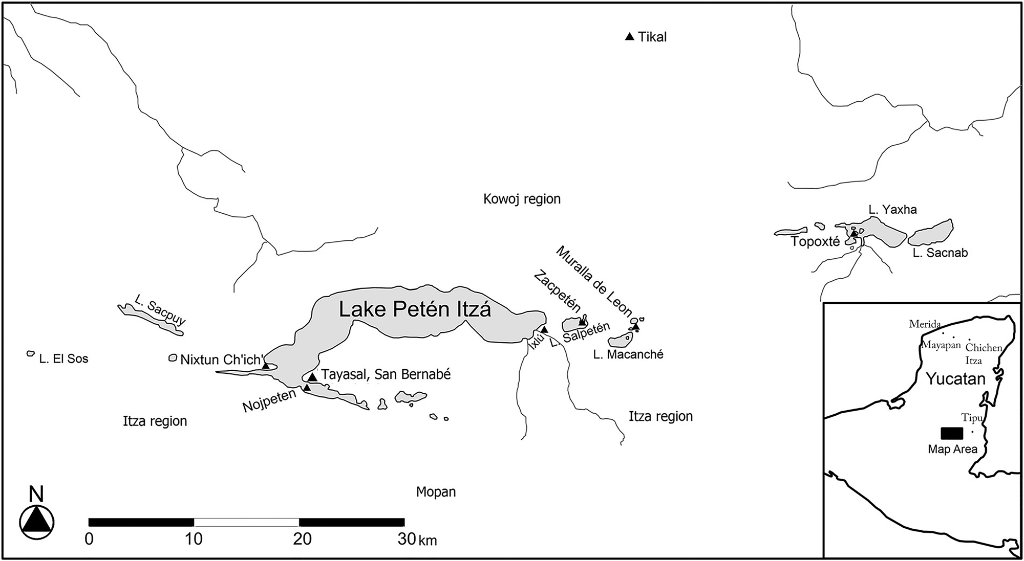
Historical, archaeological, and biogeochemical studies show the relevance of migration among Peten populations during the Classic (a.d. 250–900), Postclassic (a.d. 900–1525), and Contact (a.d. 1525–1697) periods, which sets the stage for our interpretation of Colonial period population movement. The Books of the Chilam Balam and other historical narratives describe multiple migrations between the Peten region of northern Guatemala and the northern Yucatan. Maya groups in the Peten Lakes region (Figure 1), for example, traced their origins to the northern Yucatan Peninsula, with the Itza Mayas claiming descent from Chichen Itza and the Kowoj Mayas from Mayapan. Epigraphic evidence for the name Itza at the Classic-period site Motul (de San José) and the Postclassic-period site Chichen Itza shows a longstanding relationship between the regions (Boot Reference Boot, Claessen and Vermeulen1997; Rice Reference Rice, Arnauld, Beekman and Pereira2020; Rice and Rice Reference Rice, Rice, Parker and Rodseth2005, Reference Rice and Rice2009; Shiratori Reference Shiratori, Patton and Manion2017). Similarities in architecture and other cultural traits such as burial and offering patterns also link the Itza and Kowoj Mayas to ancestral Yucatecan sites (see Pugh Reference Pugh and O'Donovan2002; Rice Reference Rice, Arnauld, Beekman and Pereira2020; Rice and Rice Reference Rice and Rice2009; Shiratori Reference Shiratori2019). Direct ties between people and the places from which they moved, however, are difficult to interpret.
Map of Peten region with sites mentioned in text. Modified from Pugh et al. (Reference Pugh, Wolf, Freiwald and Rice2016:52, Figure 1).

Studies using the isotopic compositions of bones and teeth to reconstruct migration patterns focus mainly on the Classic period and show that most migration occurred among neighboring regions, with some long-distance movement (Freiwald Reference Freiwald, Hutson and Ardren2020b; Miller Reference Miller2015a; Price et al. Reference Price, Douglas, Burton, Sharer, Buikstra, Wright, Traxler and Miller2010; Wright Reference Wright2012). Published data for Postclassic sites are consistent with Classic-period findings but include too few sites to demonstrate broader patterns. In Belize, migration is identified into Lamanai from an unknown location, and Late Postclassic movement into Baking Pot shows reoccupation of the site by individuals from the south and/or west (Donis Reference Donis2014:160–172, Appendix C; Hoggarth et al. Reference Hoggarth, Freiwald, Awe, Arnauld, Beekman and Pereira2020). Coastal Yucatan sites El Rey and Tulum had in-migration from one or more locations to the south (Ortega-Muñoz et al. Reference Ortega-Muñoz, Douglas Price, Burton and Cucina2019), as did Mayapan, where movement into the center may have originated in the Peten and the proximity of the Maya Mountains (Wright Reference Wright2007:8, Figure 3). Nonlocal individuals recovered from the cenote at Chichen Itza also show movement from the south, even as the context complicates specific interpretations about when that movement occurred or the type of migration a nonlocal isotope value represents (Price et al. Reference Price, Tiesler and Freiwald2019). These findings may reflect longstanding relationships among populations in the northern Yucatan and Peten that created migration streams with some time depth (Rice Reference Rice, Arnauld, Beekman and Pereira2020; Shiratori Reference Shiratori, Patton and Manion2017). Differences in isotope values, however, may not match political and social boundaries, and the level of pre-Hispanic mobility is likely underrepresented.
Boundaries and migration patterns shifted during the long Contact period in the Peten as colonialism spread across other parts of the Americas. Historical sources report significant levels of population movement, including transatlantic migration (Schroeder et al. Reference Schroeder, O'Connell, Evans, Shuler and Hedges2009; Price at al. Reference Price, Burton, Cucina, Zabala, Frei, Tykot and Tiesler2012). Some mobility related to postmarital residence patterns. Yucatecan parish registers from the seventeenth and eighteenth centuries show that exogamous marriage practices led as many as 2/3 of all women to relocate from their natal villages (Robinson Reference Robinson and Robinson1981). High tribute and tax burdens, famine, and disease outbreaks also factored into extensive regional population movement within the colonial world, frustrating Spanish officials who lamented the Maya ability to move expediently and frequently (Farriss Reference Farriss1984; Restall Reference Restall1997).
Long-distance movement involved flight (sensu Farriss [Reference Farriss1984]) into frontier zones such as the Peten Lakes region that were beyond Spanish rule. From the view of the colonial world, the Peten represented a frontier situated between the provincial capitals Merida and Santiago de Guatemala. Frontier communities served as buffers for exchange of both traditional goods such as cotton and cacao, as well as metal and European-introduced crops and animals (Caso Barrera Reference Caso Barrera2002:162, 228; Freiwald and Pugh Reference Freiwald and Pugh2018; Shiratori Reference Shiratori2019). There was no clear physical border or territorial marker (Parker Reference Parker2006; see Halperin et al. Reference Halperin, Freiwald and Iannone2020), however, and political boundaries moved as Maya groups rebelled and pushed the Spanish out of their territories (Jones Reference Jones1998). Social ones were even more fluid; sporadic visits by priests brought Spanish authority to mission communities such as Tipu, who then left, taking the boundary with them. The frontier may have related more to people's relationships and social memory than to physical borders (Iannone Reference Iannone2010; Voss Reference Voss2005).
From the Maya perspective, the Peten Lakes region was the center with its own internal boundaries between Kowoj, Itza, and Chakan Maya groups, among others (Meissner Reference Meissner2020). After a disastrous visit by Fray Juan de Orbita to the Itza capital in 1618, the Itza expanded eastward through Kowoj territory into what is now Belize and took control of Tipu (Jones Reference Jones1998:54–58). This expansion likely caused the Kowoj abandonment of Zacpeten in the mid-seventeenth century. A nephew of the Itza Maya king Can Ek “resided” at Tipu during the 1690s (Caso Barrera Reference Caso Barrera2002:221), and Tipuans married into the Ek royal family as well (Caso Barrera and Aliphat Fernández Reference Caso Barrera and Fernández2006). Thus, the Itza and other Maya groups were mobile and were also capable of moving boundaries.
Peoples’ identities changed as they crossed the porous and poorly defined boundaries, and new identities emerged for those they left behind. Maya vocabulary described some of the people who moved; for example, some newly arrived individuals were simply deemed hul a cab, foreigner, or hun payil vinic, a person from another village. Other terms described a man who took a wife from another village, and verb and place names differentiated places people left little-by-little versus those that were abandoned completely (Caso Barrera Reference Caso Barrera2002:131). The Spaniards and other European powers also manipulated local populations with trade goods and alliances, resulting in factionalization and ethnogenesis (Hill Reference Hill and Cusick1998).
The Peten region attracted people from other parts of the colonial world who fled to the selva or cerca del lago, or the forest or near the lakes, respectively (Caso Barrera Reference Caso Barrera2002). In some cases, nonlocal residents comprised 50 percent of villages (Caso Barrera Reference Caso Barrera2002:136; Robinson Reference Robinson and Robinson1981). Individuals, whole families, and sometimes entire communities moved, maintaining connections with their villages of origin, and the distribution of patronyms show that peoples’ movements followed a social pattern (Caso Barrera Reference Caso Barrera2002:146). In sum, the seventeenth-century Peten was a blend of longstanding migration patterns and population exchange with neighboring Maya groups and movement into the region as a reaction to colonial pressures.
COLONIAL MIGRATION AND MOBILITY
The Colonial period officially began in Guatemala's Peten region after 1697, when Spaniards and their allies defeated Itza king Can Ek at the Maya site of Nojpeten and began to consolidate populations into reducciones and mission settlements around Lake Peten Itza. They first commissioned the construction of a church in Nuestra Señora de los Remedios y San Pablo, Laguna del Itzá (or Petén del Itzá), now the modern city of Flores. Jones (Reference Jones1998) documented the locations of other early missions, such as San Miguel, San Andrés, and San Jeronimo, and by 1734, 17 settlements, including Mission San Bernabé, were located around the lake (Caso Barrerra Reference Caso Barrera2002:351).
Who lived in these settlements? Spaniards established a presidio or garrison in Flores, and estancias, or ranches, across the region. Some level of in-migration is reported; for example, Kowoj and Mopan names are associated with San Bernabé and may evidence migration from contemporaneously occupied sites, such as the Kowoj center of Zacpeten or Tipu, Belize, which was home to Mopan or Ahitza Mayas (Jones Reference Jones1977, Reference Jones1998; Rice et al. Reference Rice, Boileau, Cecil, deFrance, Freiwald, Meissner, Pugh, Rice and Yacubic2018). The Colonial period, however, brought with it a fluctuating boundary between Spanish and British controlled areas. In 1708, the Spaniards moved the Tipu Mayas to Peten to protect them from enslavement by the British, who had expanded into what is now Belize in the seventeenth century, first as pirates and later as loggers, and from attacks by the Mopan Mayas. They were settled in a town known as “de los Tipues,” which like San Bernabé, was close to the presidio (Jones Reference Jones1998:408). Furthermore, enslaved occupants of British controlled areas escaped to Peten and were ultimately settled in San Benito (Schwartz Reference Schwartz1990:66).
Most residents of the newly established missions, however, may have come from villages nearby. In Chiapas, for example, Spanish goods found in association with Late Postclassic period materials show that some colonial communities resettled close to existing villages (Gasco Reference Gasco, Kepecs and Alexander2005). San Bernabé, located 300 m from an Itza Maya settlement, is referenced in 1760s documents in the Itza Mayan language (Caso Barrera Reference Caso Barrera2002:354). While members of different communities were sometimes combined, people normally resettled with others who spoke the same language (Caso Barrera Reference Caso Barrera2002:5). Material culture from the 2010–2012 excavations supports a mainly Itza occupation based on offerings and ceramic types, with indigenous individuals who were likely related buried under the floor of the mission church (Miller Reference Miller, Pugh and Chan2015b; Pugh et al. Reference Pugh, Sánchez and Shiratori2012). Markedly different patterns emerged in food use and burial practices, however, along with more nuanced changes in ceramic styles and the presence of objects like coins that may signal new types of economic transactions (Freiwald and Pugh Reference Freiwald and Pugh2018; Pugh et al. Reference Pugh, Wolf, Freiwald and Rice2016). Isotopic assays can show whether the movement of people into the region was also one of the consequential changes marking the Peten's early Colonial period.
ISOTOPIC MIGRATION METHODS
Variation in the proportions of two forms, or isotopes, of multiple elements such as strontium (87Sr/86Sr) and oxygen (18O/16O) can serve as markers for migration. The isotope 87Sr increases over time relative to 86Sr due to the decay of rubidium-87 (Dickin Reference Dickin2005). Because the time scale is geologic rather than human—its half-life is 48.8 billion years—87Sr/86Sr in modern samples (e.g., fauna, flora, rocks, and water) will show the same values as archaeological human tissues sampled from the same place. Strontium isotope variation derives from differences in bedrock geology, aerial and fluvial inputs to soil formation processes, and how people use catchments both near and distant to their homes (Bentley Reference Bentley2006; Ericson Reference Ericson1985; Faure and Powell Reference Faure and Powell1972; Wright Reference Wright2005). Strontium is substituted into human tissues for calcium and reflects the average isotope values of calcium rich foods in the diet, which in the Maya area may include maize due to the lime added in the nixtamalization process (Burton and Wright Reference Burton and Wright1995).
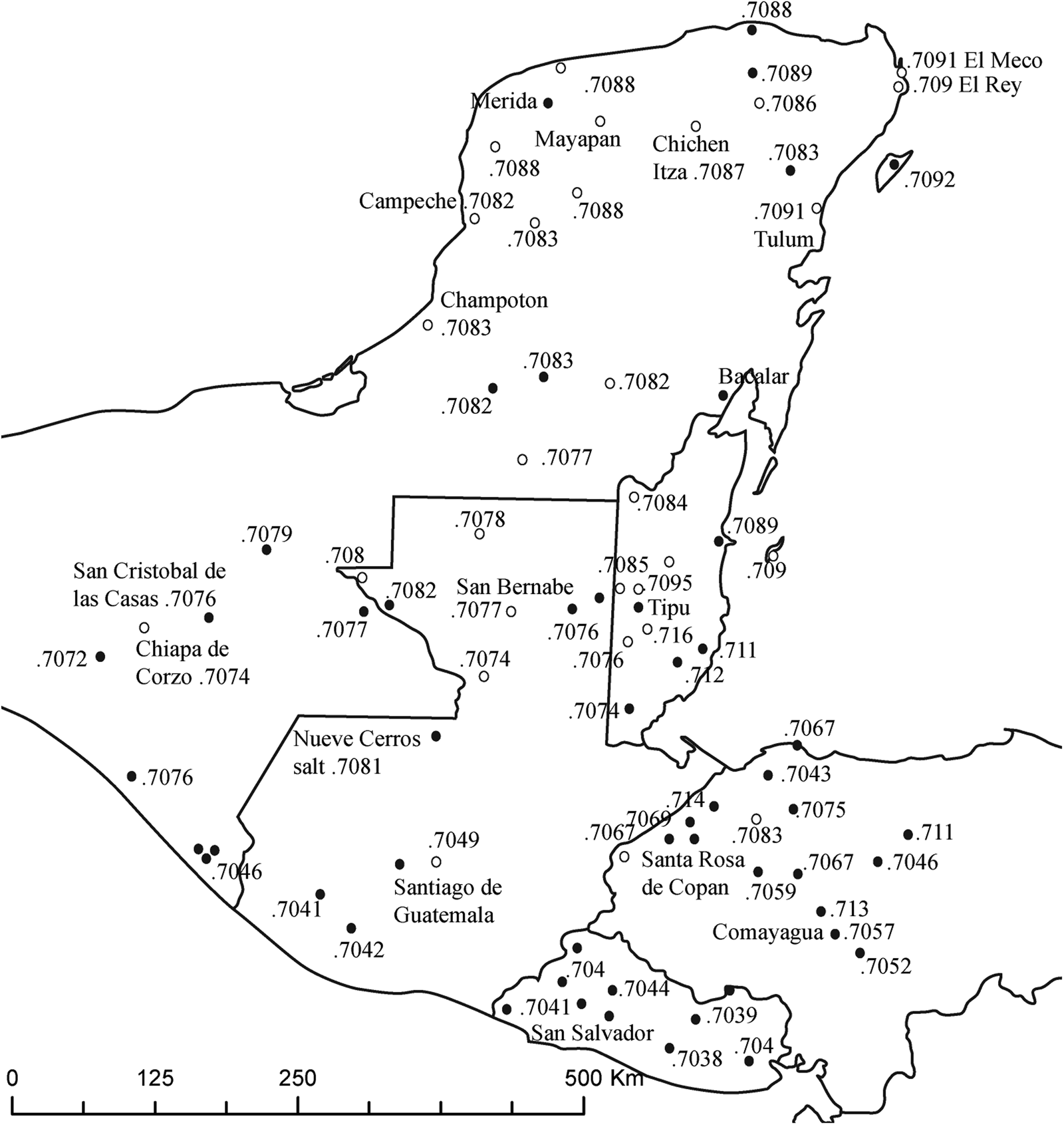
Long-distance movement in the Maya region can be identified because distinct 87Sr/86Sr values are documented for the marine carbonates that form the Yucatan Peninsula, the volcanic-derived terrains of the Guatemalan Highlands and alluvium on the Pacific coast, and the complex metamorphic and igneous formations that comprise the Motagua Valley and the Maya Mountains (Freiwald Reference Freiwald2011, Reference Freiwald, Charlotte Arnauld, Beekman and Pereira2020a; Gilli et al. Reference Gilli, Hodell, Kamenov and Brenner2009; Hodell et al. Reference Hodell, Quinn, Brenner and Kamenov2004; Price et al. Reference Price, Burton, Fullagar, Wright, Buikstra and Tiesler2008, Reference Price, Douglas, Burton, Sharer, Buikstra, Wright, Traxler and Miller2010; Thornton Reference Thornton2011). Individuals who relocated to San Bernabé from other colonial centers such as Merida, Tipu, or Santiago de Guatemala, would have strontium isotope values distinct from those found in the Peten Lakes region (Figure 2).
Strontium isotope values associated with Postclassic and Colonial centers in and around the Maya region. For detail, see Freiwald (Reference Freiwald, Charlotte Arnauld, Beekman and Pereira2020a), Freiwald et al. (Reference Freiwald, Woodfill and Mills2019), Miller Wolf and Freiwald (Reference Miller Wolf and Freiwald2018), Ortega-Muñoz et al. (Reference Ortega-Muñoz, Douglas Price, Burton and Cucina2019), Price et al. (Reference Price, Tiesler and Burton2006, Reference Price, Burton, Fullagar, Wright, Buikstra and Tiesler2008, Reference Price, Tiesler and Freiwald2019), and Suzuki et al. (Reference Suzuki, Paredes, Douglas Price, Burton and Vides2015).

Identifying nonlocal individuals, however, is not always straightforward. The number and location of the samples, and the statistical methods employed, influence interpretation of isotope values (Freiwald Reference Freiwald, Ebert, Hoggarth and Awe2018). For example, small numbers of samples with narrow ranges may include outlier values that would be considered “local” in a larger dataset in an area with greater geologic diversity and/or catchment use. In addition, strontium isotope values in the Maya region are similar to those identified elsewhere in Meso- and Central America and the Caribbean (Laffoon et al. Reference Laffoon, Davies, Hoogland and Hofman2012; Miller Wolf and Freiwald Reference Miller Wolf and Freiwald2018; Price et al. Reference Price, Burton, Fullagar, Wright, Buikstra and Tiesler2008, Reference Price, Tiesler and Freiwald2019). Isotope values are simply numbers, and additional lines of evidence, from texts to burial goods, are critical for the interpretation of their meaning. In addition, the use of other elements, such as oxygen, sulfur, or lead may serve as a proxy for migration (Green Reference Green2016; Price et al. Reference Price, Douglas, Burton, Sharer, Buikstra, Wright, Traxler and Miller2010; Rand and Grimes Reference Rand and Grimes2017; Sharpe et al. Reference Sharpe, Kamenov, Gilli, Hodell, Emery, Brenner and Krigbaum2016).
Oxygen isotope variation stems from both physiological and climatological factors. Most elemental oxygen enters the body via drinking water in humans, and the isotope ratio of 18O/16O (δ18O) fractionates through the levels of the food chain (Sponheimer and Thorpe Reference Sponheimer and Lee-Thorp1999). Nursing infants have more enriched values than their mothers, who have isotope ratios that are heavier than the water they drink, with additional variation based on physiological factors (White et al. Reference White, Longstaffe and Law2004; Wright et al. Reference Wright, Valdés, Burton, Douglas Price and Schwarcz2010). Key environmental variables in the Maya region include distance from the coast and evaporation. Oxygen isotope ratios generally decrease from the Caribbean to the Pacific Coast, with higher values in parts of the Peten region (Lachniet and Patterson Reference Lachniet and Patterson2009; Marfia et al. Reference Marfia, Krishnamurthya, Atekwana and Panton2004; also see Price et al. Reference Price, Douglas, Burton, Sharer, Buikstra, Wright, Traxler and Miller2010). Complicating factors include seasonal variation and different water sources used by people living in the same area (Scherer et al. Reference Scherer, de Carteret and Newman2015). As a result, oxygen isotope values best serve as a secondary line of evidence for population movement in the Maya region (Price et al. Reference Price, Douglas, Burton, Sharer, Buikstra, Wright, Traxler and Miller2010:9). This study uses both oxygen and strontium isotope values to identify the origins of San Bernabé individuals, in conjunction with historic evidence, to suggest multiple potential places of origin for the nonlocal individuals buried in the mission church.
SAMPLE SELECTION AND PREPARATION
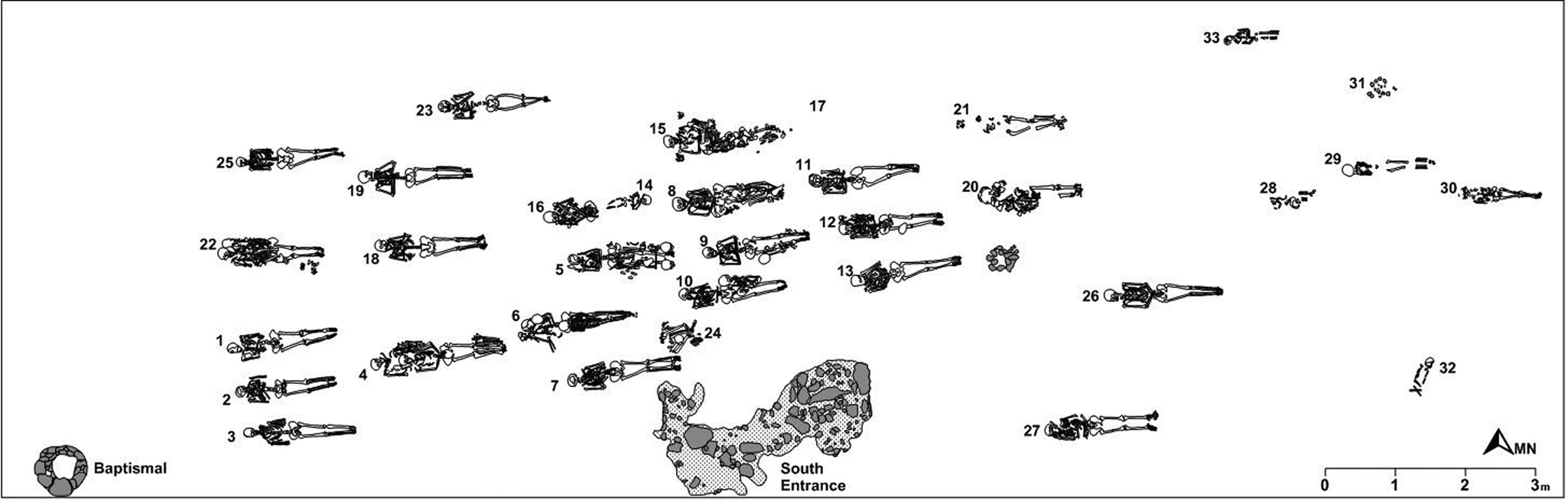
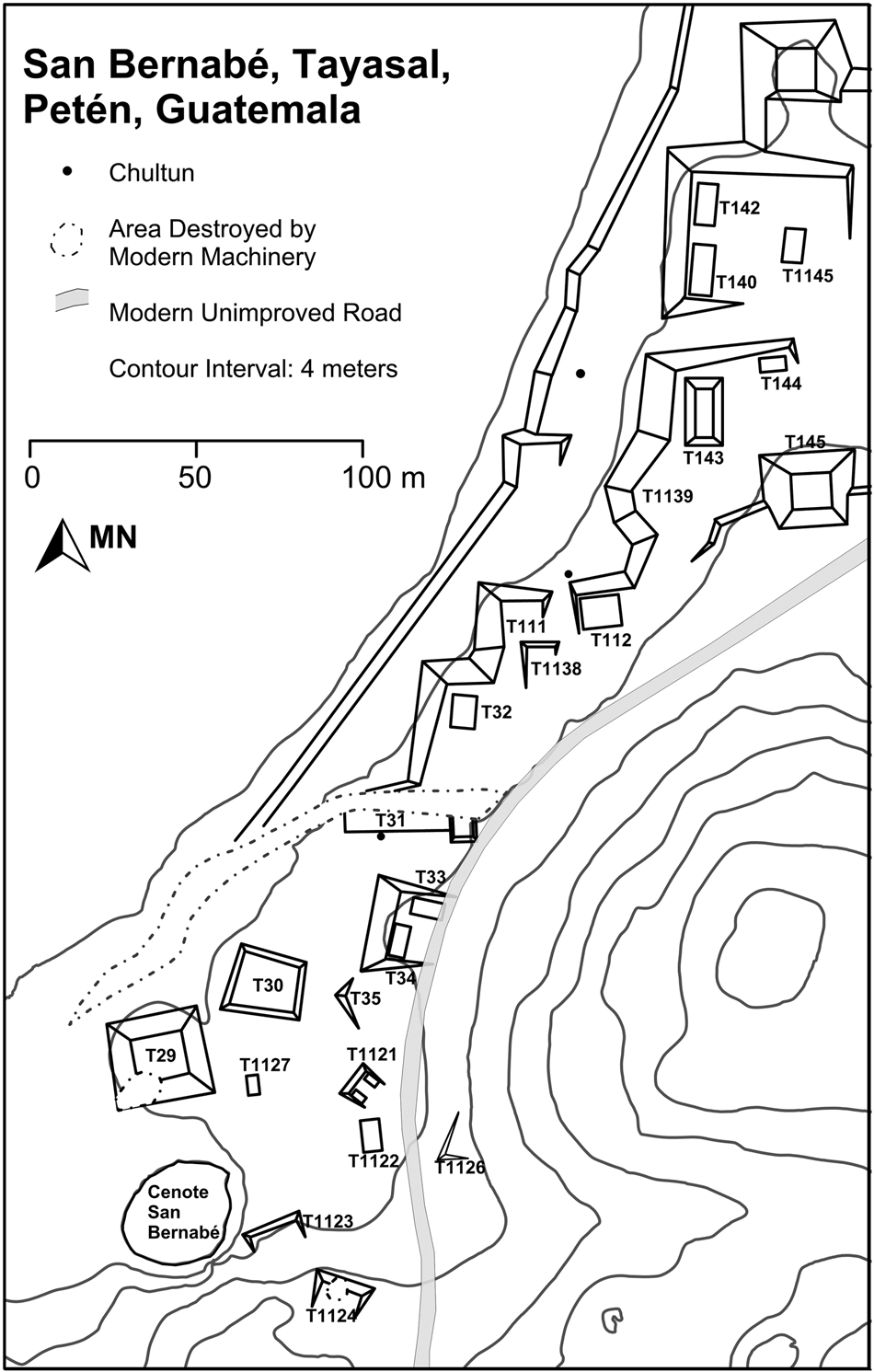
The 47 San Bernabé individuals were interred in 37 burials within the church (Structure T-31 in Figure 3), with the primary individual often placed in an extended position with the head to the west. Two exceptions include the Itza-style upright body position of Burial 24 and an infant interred with the head to the east in Burial 14 (see summary in Pugh et al. [Reference Pugh, Wolf, Freiwald and Rice2016]). The burials were oriented in rows, with the oldest ones most likely on the western side under multiple floors (Figure 4). The older graves also tended to have multiple burial episodes, with as many as five individuals placed in the same space over time and the bones of earlier decedents repositioned and stacked on top of or near the body of the most recently deceased person. The cemetery may have included related groups of individuals buried at different times (Miller Reference Miller, Pugh and Chan2015b; Pugh et al. Reference Pugh, Wolf, Freiwald and Rice2016). The sample consists of 25 individuals in 20 burials selected from all rows in the cemetery, including burials with sequential interments, to assess mobility of men, women, and children throughout the occupation of San Bernabé.
The mission church, Structure T-31, and other San Bernabé buildings. Modified from Pugh et al. (Reference Pugh, Wolf, Freiwald and Rice2016:54, Figure 4).

San Bernabé Structure T-31 mission church burials. Modified from Pugh et al. (Reference Pugh, Wolf, Freiwald and Rice2016:43, Figure 5).

Oxygen and strontium isotope values from tooth enamel sampled from 23 individuals provides a snapshot of in-migration to the site. Miller (Reference Miller, Pugh and Chan2015b) identified the individuals as 17 adults (seven female/probable females and 10 male/probable males), three adolescents (one a probable male), and three children. Because bone remodels during life, oxygen isotope values in the bone apatite of eight of these individuals, along with another adult female and child, provide a basis for interpreting residence at the end of life (Hedges et al. Reference Hedges, Clement, David, Thomas and O'Connell2007).
Most migration studies sample the first molar because the enamel mineralizes during infancy (Schaefer et al. Reference Schaefer, Black, Schaefer and Scheuer2009), thus providing the most time between birth and burial to identify a change in residence. In this study, second molars and premolars were preferentially selected because they provide limited genetic information for biodistance studies and serve as good proxies for an individual's residence during childhood but after weaning. The burial location and isotope values in bone serve as a proxy for the final residence; a significant difference in isotope values can signal migration at some point between birth and burial (Freiwald Reference Freiwald2011; Miller Reference Miller, Pugh and Chan2015b; Price et al. Reference Price, Burton, Fullagar, Wright, Buikstra and Tiesler2008; Wright Reference Wright2012).
Miller (Reference Miller, Pugh and Chan2015b) completed osteological analyses including collecting metric and non-metric biodistance data, then Freiwald photographed the teeth using a DinoLite digital microscope AM4013T and made polysiloxane molds for cast reproductions of the tooth crowns. Teeth were sonicated for 15 minutes in distilled water before enamel samples were prepared by abrading the side of one tooth cusp. Visible surface contamination and dentin were removed using a Microlab variable speed dental drill equipped with a diamond bur under a microscope. The enamel chip was removed using a diamond disc (Freiwald Reference Freiwald, Ebert, Hoggarth and Awe2018). Five mg of enamel were processed at the University of North Carolina at Chapel Hill's Geochronology and Isotope Geochemistry Laboratory for strontium isotopes, and the oxygen isotopes of two mg of powdered enamel were analyzed at the University of Arizona's Environmental Isotope Laboratory.
87Sr/86Sr values were obtained by isotope dilution thermal ionization mass spectrometry using a VG Sector 54 instrument. Each sample was dissolved in 3.5 M HNO3 and the strontium was purified using Eichrom Sr-Spec resin. Samples were loaded on single rhenium filaments in phosphoric acid and tantalum chloride solution and analyzed on a VG Sector 54 as a metal in dynamic multicollector mode with 88Sr = 3V. Strontium isotopic ratios were corrected for mass fractionation using an exponential law correction and normalized to 86Sr/88Sr = 0.1194. Replicate analyses of the NBS 987 Sr standard yielded 87Sr/86Sr = 0.710250 ± 0.000015 (2σ, n = 20).
For oxygen isotope analysis, tooth enamel samples were first washed in a 0.2 M acetic acid for one to two hours and rinsed three times with distilled water. Samples were measured against δ18O using reference values from Craig (Reference Craig1957) with an automated Finnegan Delta S VG602C mass spectrometer with analytical precision of 0.11‰ and 2σ = 0.08‰. δ18O is measured relative to Standard Mean Ocean Water (SMOW), determined as follows: δ18O = 1000 × [((18O/16O) sample)/(18O/16O) SMOW) – 1]. Standards include SMOW and VSMOW.
Finally, powdered bone samples were treated with 1.8 mL NaOCl (~1.7% v/v), then reacted with 1.0 mL 0.1 M acetic acid (CH3COOH) solution under constant agitation for approximately eight minutes, prior to freeze-drying (Garvie-Lok et al. Reference Garvie-Lok Sandra, Varney and Anne Katzenberg2004). The oxygen isotope values of samples weighing two milligramswere analyzed on a Delta V-Plus I GS-IRMS via continuous-flow. Although the samples were not run in duplicate, analytical precision based on two internal standards and an international standard (NBS-19) run with the samples was better than ±0.07. Results are displayed in Table 1.
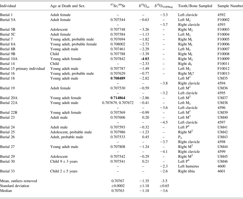
Demographic distribution, sample information, and strontium and oxygen isotope values. Bold values are statistical outliers.

INTERPRETING ISOTOPIC MIGRATION
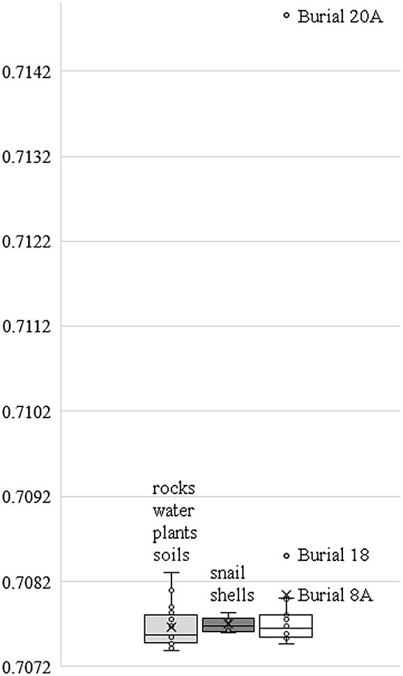
Strontium and oxygen isotope values indicate a nonlocal origin for at least three individuals buried in the San Bernabé mission church using mean and median-based statistics (Table 1). The values of Burial 20A (87Sr/86Sr = 0.714864) and Burial 18 (87Sr/86Sr = 0.708489) fall outside the interquartile range (IQR; Figure 5). IQR is based on the median value, which is appropriate for a positively skewed strontium isotope sample (skewness = 4.43) that is more normally distributed when the two outlier values are removed (skewness = 0.77). In addition, Burial 8A (87Sr/86Sr = 0.708002) is also a statistical outlier from the IQR but falls within two standard deviations of the mean and is nearly identical to the value of Burial 25 (87Sr/86Sr = 0.707986). Finally, the δ18Oen value of the young adult female in Burial 10A (−4.03‰) is more than two standard deviations from the mean in a normally distributed oxygen isotope dataset (skewness = −0.37). Thus, a minimum of two females and one male relocated to San Bernabé, died as young adults (aged 20–35; Buikstra and Ubelaker Reference Buikstra and Ubelaker1994:36), and were buried in the mission church.
Interquartile range of strontium isotope values in regional baseline samples and San Bernabé burials. Rock, water, plant, and soil values from Hodell et al. (Reference Hodell, Quinn, Brenner and Kamenov2004).

Each of the nonlocal individuals was born in a different location. The strontium isotope value of the young woman in Burial 10A (87Sr/86Sr = 0.707842) is similar to those found across the central lowlands, including in and around Lake Peten Itza (Figure 5); however, her depleted δ18O value is a statistical outlier (-4.03‰). Similar average oxygen isotope values are present at many other Maya lowland sites, including Tikal (-3.8‰ δ18O average value for 150 samples, in Price et al. Reference Price, Douglas, Burton, Sharer, Buikstra, Wright, Traxler and Miller2010:9, Table 1). Variation among the remaining samples is discussed in more detail below.
The origin of the young man in Burial 18 (87Sr/86Sr = 0.708489) is not easy to pinpoint because similar values are found in multiple places. The closest locations with these values are found at eastern lowland centers such as Nakum and San Bartolo, extending into the Belize Valley and along the coastal Yucatan Peninsula (Davies Reference Davies2012; Freiwald Reference Freiwald2011; Price et al. Reference Price, Burton, Fullagar, Wright, Buikstra, Tiesler and Cucina2015; Rand et al. Reference Rand, Matute, Grimes, Freiwald and Źrałka2020). Similar values also exist in small burial samples to the west (Palenque) and distant south (Honduras; Price et al. Reference Price, Burton, Fullagar, Wright, Buikstra and Tiesler2008; Wells et al. Reference Wells, Davis-Salazar, Moreno-Cortés, Stuart and Novotny2014). In-migration from the east is the most likely origin for the young woman in Burial 20A, whose value (87Sr/86Sr = 0.714864) is similar to those uniquely identified near the foothills of the Maya Mountains and Mountain Pine Ridge (Freiwald Reference Freiwald2011, Reference Freiwald, Hutson and Ardren2020b; Wrobel et al. Reference Wrobel, Freiwald, Michael, Helmke, Awe, Kennett, Gibbs, Ferguson and Griffith2017). Historical connections to the region also support an eastern origin for Burial 18. Interactions with Tipu and other populations to the east are reported during the Peten's Contact period, and likely earlier, but there is little published isotopic information from other colonial settlements available for comparison (Donis Reference Donis2014; Price et al. Reference Price, Tiesler and Burton2006; Trask Reference Trask2018). It is clear that people were moving; the strontium, oxygen, and sulfur isotope values of one Colonial period individual buried at the Classic-period site Cahal Pech show movement from the southern lowlands into the Belize Valley (Awe et al. Reference Awe, Ebert, Freiwald and Green2017).
Strontium isotope values from the Peten Lakes and neighboring regions also allow an exploration of “local” isotope values. Burial 24, the Itza-style seated interment, had isotopic values consistent with a local origin, as did two individuals (Burials 14 and 16) not interred in the same medieval Christian style as the majority of the San Bernabé burials (Pugh et al. Reference Pugh, Wolf, Freiwald and Rice2016). Individuals interred in the same graves had similar strontium isotope values ranging from 0.7075 to 0.7077 87Sr/86Sr, including Burial 5 (Individuals A, B, and C) and Burial 22 (Individuals A and B). The values for two individuals in Burial 8, however, suggest some difference in childhood food sources for individuals in the same grave. There is variation in local strontium isotope values from Zacpeten (0.70762), Yaxha (0.70774), Topoxte (0.707837), and Muralla de Leon (0.70759), and 16 water, four rock, two soil, and three plant samples collected by Hodell and colleagues (Reference Hodell, Quinn, Brenner and Kamenov2004:596–597) that average 0.70766 ± 0.0002. It may not be possible, however, to differentiate human populations living on the shores of the Peten Lakes.
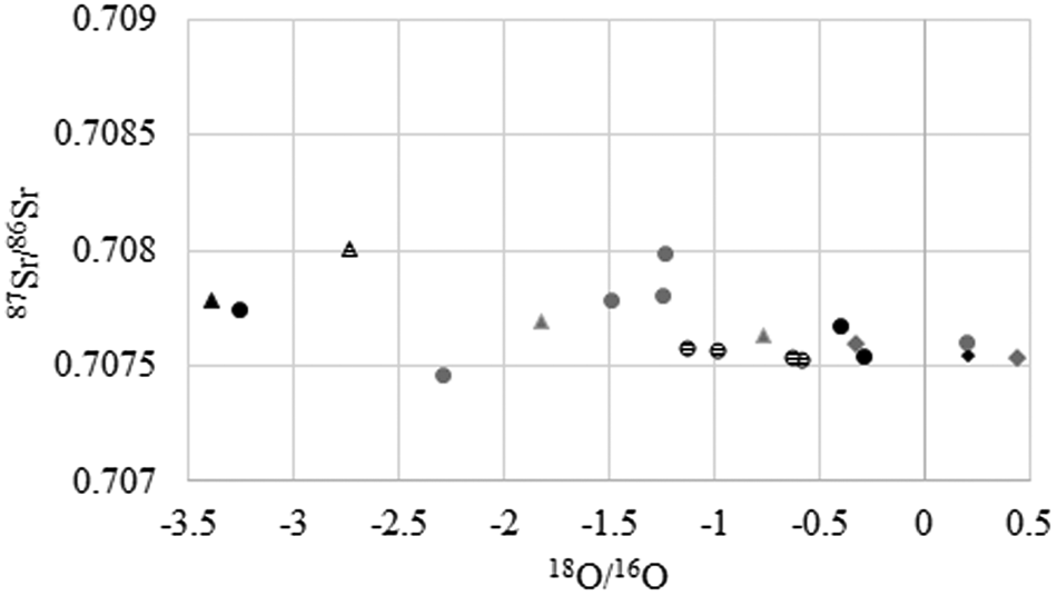
There is variability among the oxygen isotope values that suggests different drinking water sources as the teeth formed. In fact, one grave (Burial 5 Individuals A–C) captures almost the whole of the variability in the sample set (–3.26 to –0.63‰). The differences should not result from nursing-related fractionation. Wright et al. (Reference Wright, Valdés, Burton, Douglas Price and Schwarcz2010) showed that first and second molars sampled at Kaminaljuyu had similar oxygen isotope values as compared to third molars, which had δ18Oen values on average 0.7‰ lower due to the enrichment of oxygen isotope values in breast milk. Figure 6 shows dispersed values for all tooth types, and average δ18Oen values for second molars (–1.36‰) and other teeth (–1.34‰) are similar.
Isotope variation shown by tooth type: second molars (circles), first molars (triangles), and premolars (diamonds). Males are represented as gray, females as a striped pattern, and subadults as black icons. Three statistical outlier values are removed (Burials 10A, 18, and 20A).

Childhood δ18Oen values of females cluster more closely (within 1‰) than those of males (2‰), but the difference is not statistically significant (x2 = 0.875, p-value = 0.349). If the differences related to gendered activities, the oxygen isotope values in the bone samples of adult men and women should also differ, and they do not. The oxygen isotope values in the bones of three females, five males, and two children in Table 1 are more similar than those of the tooth enamel (δ18OVDPBap = –3.65 ± 0.65). The values of the two children are enriched by 1‰, which may show the effect of nursing as the bones formed and continued to remodel. The bone and enamel values are not directly comparable as different sample types and pretreatments may affect the values (Garvie-Lok et al. Reference Garvie-Lok Sandra, Varney and Anne Katzenberg2004; Koch et al. Reference Koch Paul, Tuross and Fogel1997; Pestle et al. Reference Pestle, Crowley and Weirauch2014). The most parsimonious interpretation of the δ18Oen variation may be that people using different water sources as their teeth formed relocated to San Bernabé, mainly from areas with similar strontium isotope values, and their bones subsequently remodeled to local oxygen isotope values.
CONCLUSION
Despite Spanish accounts of significant mobility during the Colonial period, most residents of Mission San Bernabé may not have moved. Instead, it was the boundary that moved and brought New Spain and its non-Maya people, animals, ideas, and gods, to Guatemala's Peten region. The church at Mission San Bernabé included the burials of nonlocal individuals whose strontium and oxygen isotope values suggest origins in at least three distinct places, one of which is in the vicinity of the Maya Mountains. This may represent in-migration from the area near the Tipu mission settlement; however, historic documents show that people moved between these areas—and others—before the arrival of the Spanish as well. Overall, the isotopic data fail to show a dramatic shift either in the scale or direction of in-migration to the region despite accounts of high rates of mobility during the Colonial period.
The isotope values instead support archaeological and biological data that reveal a mission settlement comprised of related groups of people following Itza ceramic traditions (Pugh et al. Reference Pugh, Sánchez and Shiratori2012, Reference Pugh, Wolf, Freiwald and Rice2016). San Bernabé residents likely came from within the region as the Spanish resettled Itza and other Maya populations in newly established missions around the lake (Caso Barrera Reference Caso Barrera2002). Diversity in local origins provides one potential explanation for δ18Oen and 87Sr/86Sr variation in the ‘local’ San Bernabé values, as does historic evidence that places non-Itza Mayas at the mission (Jones Reference Jones1998). aDNA and biodistance analyses are underway to further investigate the mission population. It also is worthy to consider who did not reside in the mission. Refugees who had fled colonial rule into the Peten likely remained in a smaller, but ever-present frontier that the Spanish could never fully eliminate.
Isotopic methods provide one view into the past but cannot capture in-migration from areas with the same isotopic signatures, multiple moves during an individual's lifetime, or travel and temporary visits. These data also cannot track the people who left San Bernabé, perhaps seeking healthier conditions, but eventually leaving altogether because ultimately the mission settlement was abandoned. The people buried within the walls of the church did not survive the disruptions of illness, violence, and a lack of food that the colonial system introduced (Caso Barrera Reference Caso Barrera2002; Jones Reference Jones1998; Miller Reference Miller, Pugh and Chan2015b). Ongoing research on health and diet will provide a more complete picture of these changes at San Bernabé.
RESUMEN
El periodo colonial llegó tarde al norte de Guatemala. Después del contacto inicial entre los españoles y los Mayas Itzaes en 1525 d.C., los españoles tardaron hasta el principio del siglo 18 para ganar control de la región de los lagos del Petén y empezaron a establecer misiones. Excavaciones durante los años 2010–2012 en la misión San Bernabé, ubicado en las riberas del lago Petén Itzá, recuperaron materiales y especies de animales europeos, también revelando patrones funerarios que señalaron la introducción de un estilo de vida nueva. ¿Quién vivió en la misión San Bernabé? Los españoles establecieron pueblos nuevos cerca del lago, congregando las poblaciones indígenas, un método de facilitar el proceso de colonización. Animales domesticados no locales en San Bernabé sugieren conexiones al sur en terrenos controlados por los españoles. No obstante, los isotopos del estroncio y oxigena en el esmalte y hueso de personas enterradas debajo del piso de la iglesia en la misión sugieren orígenes regionales por los residentes de San Bernabé. Nuestros resultados muestran migración del centro de Belice, una región ya controlado nominalmente por los españoles que históricamente tenían conexiones con poblaciones del Petén. Los datos isotópicos no son consistentes con movimientos grandes descritos en documentos españoles y pueden representar el intercambio de personas, materiales, e ideas antes de la llegada de los españoles a pesar de los cambios que introdujeron. Al fin, los cambios no tienen raíces en inmigrantes cruzando la frontera; fue la frontera que cambió, trayendo el mundo colonial a los Mayas viviendo en el Petén.
ACKNOWLEDGMENTS
Funding was provided by National Science Foundation grants (BCS-0917918 and BCS-1037927), Queens College of the City University of New York, the Research Foundation of the City University of New York, and Wenner-Gren foundation (Pugh); the University of Mississippi (Freiwald); and Indiana University East and the Women's Philanthropic Leadership Council, Indiana University Board of Trustees (Miller Wolf). The Instituto de Antropología e Historia gave permission to export samples and do the analyses. We thank students and faculty of the Centro Universitario del Petén, Miriam Salas, Evelyn Chan Nieto, Carlos Sánchez, and Proyecto Arqueológico Tayasal project members. We also acknowledge collaborations with Drew Coleman (University of North Carolina at Chapel Hill), James Burton and T. Douglas Price (University of Wisconsin T. Douglas Price Laboratory for Archaeological Sciences), David Dettman (University of Arizona Laboratory for Environmental Isotopes), and Memorial University of Newfoundland's Vaughan Grimes (Memorial Applied Archaeological Sciences Laboratory) and Hilary Keats (Stable Isotope Laboratory).