

Introduction
Mosquitoes are insects of major public health concern, mainly for their role as vectors of pathogens to humans and animals (WHO, 2002; Snow et al., Reference Snow, Guerra, Noor, Myint and Hay2005). The geographic distribution of several vector-borne viral diseases, such as West Nile virus and Rift Valley fever are currently expanding (Gubler, Reference Gubler2002; Morales et al., Reference Morales, Barrandeguy, Fabbri, Garcia, Vissani, Trono, Gutierrez, Pigretti, Menchaca, Garrido, Taylor, Fernandez, Levin and Enria2006), and a rise in morbidity and mortality is noticeable (Rezza et al., Reference Rezza, Nicoletti, Angelini, Romi, Finarelli, Panning, Cordioli, Fortuna, Boros, Magurano, Silvi, Angelini, Dottori, Ciufolini, Majori and Cassone2007). In Argentina in 2005, an outbreak of viral meningo-encephalitis, mainly by the mosquito-borne Saint Louis Encephalitis virus (SLEv; Flaviviridae), was recorded in Córdoba province (Diaz et al., Reference Diaz, Ré, Almirón, Farías, Vazquez, Sanchez-Seco, Aguilar, Spinsanti, Konigheim, Visintín, García, Morales, Tenorio and Contigiani2006). West Nile virus (WNv), first reported in North America in 1999, was detected in horses (Morales et al., Reference Morales, Barrandeguy, Fabbri, Garcia, Vissani, Trono, Gutierrez, Pigretti, Menchaca, Garrido, Taylor, Fernandez, Levin and Enria2006) and humans (ProMED-Mail, 2006) early in 2006. Thus, further studies on the ecology and biology of vector populations are justified.
Urban ecosystems may affect mosquito populations by offering larval habitat, refuges and adequate microclimates to survive the winter. Deforestation and new urbanizations promote larval habitats in artificial containers (Jacob et al., Reference Jacob, Regens, Mbogo, Githeko, Keating, Swalm, Gunter, Githure and Beier2003; Leisnham et al., Reference Leisnham, Lester, Slaney and Weinstein2004). Shaded and vegetated neighbourhoods, with plenty of sites less exposed to sunlight and with taller and closer vegetation, were found the most favourable microhabitats for A. aegypti larvae in Buenos Aires (Argentina) (Vezzani et al., Reference Vezzani, Rubio, Velazquez, Schweigmann and Wiegand2005). The abundance of two malaria vectors, Anopheles funestus and A. gambiae s.s., in Western Kenya Highlands was related to housing characteristics and land cover; adult abundance was higher in areas with low tree canopy coverage (Zhou et al., Reference Zhou, Munga, Minakawa, Githeko and Yan2007, and references therein).
Urban landscape characteristics may also influence the epidemiology of mosquito-borne diseases by affecting host availability and accessibility. Highly diverse host communities have been related to lower infection risk of vector-borne diseases, probably by reducing human exposure to the pathogens through a ‘dilution effect’ (Ezenwa et al., Reference Ezenwa, Godsey, King and Guptill2006). Urbanization alters the composition of avian communities, favouring those species that can take advantage of anthropogenic habitats (Marzluff et al., Reference Marzluff, Bowman and Donelly2001). Associations between land cover variables and prevalence of WNv have been detected in Chicago and Detroit, with a higher prevalence in suburbs dominated by 1940–1960 housing, with moderate vegetation cover, that may allow combinations of mosquito species and birds needed to sustain transmission (Ruiz et al., Reference Ruiz, Walker, Foster, Haramis and Kitron2007).
Remote sensing and geographic information systems (GIS) provide resources to analyze data involving a spatial component, such as the relation between vector populations, land cover and land use (for example Nicholson & Mather, Reference Nicholson and Mather1996; Gleiser et al., Reference Gleiser, Gorla and Schelotto2002; Masuoka et al., Reference Masuoka, Claborn, Andre, Nigro, Gordon, Klein and Kim2003; Hay et al., Reference Hay, Graham and Rogers2006; Gleiser & Gorla, Reference Gleiser and Gorla2007). The present work studied the spatial distribution of multiple mosquito species within an urban environment in a temperate region. In particular, it explored the correlates of abundance of potential vectors and landscape characteristics.
Material and methods
Study area and mosquito sampling
The study area was the city of Córdoba, homonym province, located in the centre of Argentina (64°11′W–31°24′S) at 360–480 m above sea level (http://www.cordoba.gov.ar/). It has a population of approximately 1,290,000 inhabitants (INDEC, 2001). The climate is temperate, mesothermal, with an average summer temperature of 24°C and average winter temperature of 11°C. Rainfalls prevail during October to December and March, with an average annual rainfall ranging between 750 and 800 mm (Jarsún et al., Reference Jarsún, Gorgas, Zamora, Bosnero, Lovera, Ravelo, Tassile, Gorjas and Tassile2003).
Adult mosquitoes were collected with CDC miniature light traps baited with dry ice as a source of CO2 (Service, Reference Service1993) from spring (October 2005) to fall (March 2006). The time frames cover the warm and rainy season, when peaks of mosquito abundance are more likely to occur in the area. Traps were operated from dusk to dawn among 24 sites. In November, only eight sites were sampled. However, those sites were spread throughout the city, and mosquitoes were almost absent from traps, suggesting their populations were very low at the time. On another seven isolated occasions, technical problems (such as trap malfunctions, inaccessibility to a site) precluded sampling; thus, in all there were a total of 121 trap nights. Sampling sites were selected to represent different levels of urbanization and land cover, from highly constructed (0% unbuilt lots), to suburban and open areas (55% unbuilt lots), and were located at varying distances from waterways (ranging from 15 to 3200 m). Mosquitoes were determined to species level in the laboratory based on morphological characters (Darsie, Reference Darsie1985; Almirón, Reference Almirón1992).
Spatial analyses
Latitude and longitude coordinates of the sites were recorded with a global positioning system (GPS) (Garmin Surveyor Global Positioning System) for GIS processing using Idrisi Andes (Eastman, Reference Eastman2006). Vector layers were generated for site location, and for presence and abundance of each species.
In order to assess macro-scale factors that the spatial distribution of mosquitoes may be related to, the following landscape characteristics were estimated for a circular buffer area (radius 400 m) around each sampling site:
1. The normalized differences vegetation index (NDVI) was used as an overall indication or ‘proxy’ of vegetated surfaces, and was calculated as a ratio between measured reflectivity in the red and NIR portions of the electromagnetic spectrum estimated from Landsat images of Cordoba City from January 2006. The NDVI is a spectral index that relates to plant biomass (Tucker & Sellers, Reference Tucker and Sellers1986) and is computed directly without any bias or assumptions regarding plant physiognomy, land cover class, soil type or climatic conditions.
2. The presence and proximity to waterways (river, creek, lagoons and water channels) because they may provide larval breeding habitat in pools on margins. Also, drain ditches flow to the creeks and river, and their flood pools may also provide suitable larval habitat.
3. The number of unbuilt lots, unbuilt and built lot surfaces were obtained from the City Hall for each neighbourhood where sampling sites were set (http://www.cba.gov.ar/). The following proxy variables (indicators of construction density) were estimated for each sampling site: (i) % of unbuilt lots: percentage of lots that are not built in a neighbourhood (complements percentage of built lots); (ii) % of unbuilt surface: for each neighbourhood, the percentage of the total surface (m2) covered by unbuilt lots, and (iii) % of built surface: percentage surface covered by housing and other building constructions.
4. The percentage surface covered by and proximity to informal settlements. Informal settlements consist of small, irregular, precarious dwellings, frequently assembled from pieces of plywood, wood and corrugated metal, lacking the most basic services, including sanitation systems. Sewer ditches are usually seen along the unpaved streets. Due to sanitation conditions and availability of open containers, they were expected to provide breeding sites for mosquitoes. Maps on the distribution of informal settlements were obtained from the City Hall.
Statistical analyses
Spearman′s rank correlation (R) was used to evaluate the relation between the average and coefficient of variation of female abundance at each site with each of the landscape variables described above. A linear correlation (R2) examined the relation between total mosquito abundance and the number of species collected. A P-value ⩽0.05 was considered statistically significant.
Results
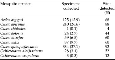
A total of 1167 specimens belonging to nine species within Aedes, Culex and Ochlerotatus genus were collected, and 87% of them were female. Table 1 shows the species collected in the study area and the percentage of sites positive for each species (115 specimens could only be identified as Culex spp. because of missing appendices and/or scales, and were not included in the table or further data analysis). Culex quinquefasciatus Say and C. apicinus Philippi were by far the most widely distributed and abundant species, followed by A. aegypti. Ochlerotatus albifasciatus (Macquart) represented only 3% of the total number of mosquitoes collected, but was present at 52% of the sites.
Mosquito specimens collected at 25 sampling sites and percentage of sites where each species was detected in Córdoba city, homonym province, from October 2005 to April 2006.

The number in parenthesis is the percentage of the total sample.
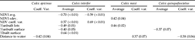
To assess the relation between landscape characteristics and mosquito abundance, the average and coefficient of variation of female abundance at each site were correlated to each of the landscape variables. Significant correlations are presented in table 2.
Correlations between mosquito abundance at 25 sampling sites and landscape variables in Córdoba city, homonym province.

Values in table are Spearman′s R. P-values are included in parenthesis. Only correlations with P<0.08 are shown.
avg., average; sdev., standard deviation; coeff. var., coefficient of variation.
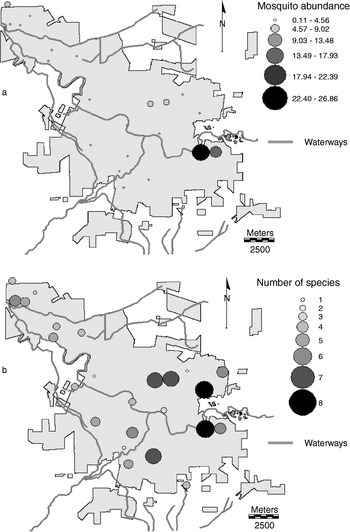
The spatial distribution of mosquito abundance was biased, showing a higher percentage of mosquitoes collected at a site to the east of the city (fig. 1a). Species diversity (represented by the number of species collected) showed a less clustered distribution, but was also higher on the eastern sites (fig. 1b). Although a significant relationship was detected between mosquito abundance (ln (n+1)) and species diversity (R 2=0.72, P⩽0.5), some sites representing a low proportion of specimens collected (ranging from 2 to 3% each) yielded six or more different species.
Distribution of sampling sites in Córdoba city. (a) Mosquito abundance, expressed as percentage of mosquitoes collected at each site; (b) species diversity, estimated as number of species collected at each site.

Discussion
The presence of mosquito species of sanitary importance was recorded throughout the study (table 1). C. quinquefasciatus, the most abundant and widespread species, is a suspected urban vector of SLEv (Mitchell et al., Reference Mitchell, Monath and Sabattini1980; Diaz et al., Reference Diaz, Ré, Almirón, Farías, Vazquez, Sanchez-Seco, Aguilar, Spinsanti, Konigheim, Visintín, García, Morales, Tenorio and Contigiani2006). In fact, in the present study, the site of highest C. quinquefasciatus abundance was located within an area of high SLEV prevalence and risk of infection (Spinsanti et al., Reference Spinsanti, Farías, Aguilar, Díaz, Ghisiglieri, Bustos, Vilches, Gonzalez and Contigiani2007). C. interfor was another spatially widespread species collected that might be involved in the cycle of SLEv. This virus has been isolated from C. interfor specimens sampled at the residence of an SLE confirmed patient in Córdoba (Diaz et al., Reference Diaz, Ré, Almirón, Farías, Vazquez, Sanchez-Seco, Aguilar, Spinsanti, Konigheim, Visintín, García, Morales, Tenorio and Contigiani2006). It would be worthwhile to assess the potential involvement of C. apicinus in the SLE cycle because this domestic species, cited as ornitophilic in Córdoba (Almirón & Brewer, Reference Almirón and Brewer1995), was collected since the spring-time (October), when the SLE virus may be amplifying.
Although C. quinquefasciatus was the most frequent species, only a few sites were more productive in terms of the number of specimens collected. The site of highest abundance was located close to the river and ponds rich in organic matter, in proximity to informal settlements and garbage dumps, which may provide a wide availability of larval habitats. Immature stages of this species have been collected in diverse habitats, including cisterns, tires, flowerpots, pools in drains and ponds (Almirón & Brewer, Reference Almirón and Brewer1996; Stein et al., Reference Stein, Oria and Almirón2002; Pires & Gleiser, Reference Pires and Gleiser2007). C. quinquefasciatus has been reported to share larval habitats with A. aegypti; however, their spatial distributions were not correlated (R2=0.16, P=0.45), which may be a consequence of C. quinquefasciatus taking advantage of a wider range of larval habitats (Almirón & Brewer, Reference Almirón and Brewer1996; Pires & Gleiser, Reference Pires and Gleiser2007). Although no significant correlations were detected between C. quinquefasciatus and the landscape variables evaluated, a negative tendency between abundance and percentage of unbuilt surface was observed, probably reflecting the adaptability of this species to the urban environment. Local characteristics at a lower scale than considered may be more relevant to explain spatial variations in C. quinquefasciatus abundance. On the other hand, C. interfor abundance was negatively correlated with NDVI and positively correlated with the percentage of built surface, suggesting a preference for densely constructed areas.
The NDVI was an important variable in several predictive models of A. aegypti larval index developed for a dengue endemic area in north-western Argentina (Estallo et al., Reference Estallo, Lamfri, Scavuzzo, Ludueña, Introini, Zaidenberg and Almirón2008). Considering that this mosquito species has a short dispersal rate, usually clustering 1 to 30 m from houses (Getis et al., Reference Getis, Morrison, Gray and Scott2003; Lourenço-de-Oliveira et al., Reference Lourenço-de-Oliveira, Castro, Braks and Lounibos2004) and dispersing up to 320 m from a release point (Liew & Curtis, Reference Liew and Curtis2004), a similar relation between landscape and mosquito abundance was expected for Córdoba. However, no significant correlations were found, suggesting that, at least during the rainy season, availability of water-holding containers was widespread. It would be interesting to assess whether this pattern changes seasonally.
Culex apicinus and C. maxi showed opposing patterns regarding their relationship with waterways. C. maxi abundance tended to be less variable near waterways, and collections were higher as the percentage of unbuilt lots increased, probably reflecting availability of breeding sites. Immature of this species have been collected in the city in stream margins and pools in margins of rivulets, rivers and road drains (Almirón & Brewer, Reference Almirón and Brewer1996) and temporary pools in association with O. albifasciatus (Pires & Gleiser, Reference Pires and Gleiser2007). A significant correlation between abundance and variability of the NDVI suggests a preference for heterogeneous urban habitats such as suburbs, where constructed lots alternate with open spaces, as opposed to areas where the construction density is high.
The identification of areas with consistently high numbers of mosquitoes, which may also have higher risk of disease transmission (Ribeiro et al., Reference Ribeiro, Seulu, Abose, Kidane and Teklehaimanot1996), is relevant to target mosquito surveillance and selective control measures. The detection of significant correlations between some species and landscape characteristics, that were consistent with previous knowledge about their ecology and larval habitat preferences, encourages more detailed studies, both spatially and temporally, and the incorporation of geographic information systems as an aid in the evaluation, planning and decision making for vector control operations.
Acknowledgements
We are grateful to W. Almirón and G. Rossi for their assessment in taxonomic determination of Culex specimens. We would like to acknowledge an anonymous reviewer for constructive comments on the manuscript that helped improve it. This work has been partly funded by CONICET, SECYT-UNC and FONCYT. We acknowledge CONAE (National Spatial Commission, Argentina) for the provision of satellite imagery under ‘PlagaSat’ project.