INTRODUCTION
Chile has agreed to an international conservation goal to protect at least 17% of each of the country's ecoregions by 2020. But studies have shown Chile's national protected area network (PAN) has not been systematically established and is ineffective at protecting the most threatened priority conservation area (PCAs) or proportionally representing the country's biodiversity. Based on the theory of representativeness – the extent to which a PAN protects biological diversity (Lunney et al. Reference Lunney, Pressey, Archer, Hand, Godthelp and Curtain1997; Juffe-Bignoli et al. Reference Juffe-Bignoli, Burgess, Bingham, Belle, de Lima, Deguignet, Bertzky, Milam, Martinez-Lopez, Lewis, Eassom, Wicander, Geldmann, van Soesbergen, Arnell, O'Connor, Park, Shi, Danks, MacSharry and Kingston2014) – a proportionally representative PAN captures an equal percentage of a range of biodiversity across biological scales (species and ecosystems) and realms (terrestrial, freshwater, or marine areas) (Margules & Pressey Reference Margules and Pressey2000; Juffe-Bignoli et al. Reference Juffe-Bignoli, Burgess, Bingham, Belle, de Lima, Deguignet, Bertzky, Milam, Martinez-Lopez, Lewis, Eassom, Wicander, Geldmann, van Soesbergen, Arnell, O'Connor, Park, Shi, Danks, MacSharry and Kingston2014; WWF 2014). Broadly speaking, proportionally representative PANs are considered effective and non-proportionally representative PANs are considered ineffective because they exhibit representation bias. Bias occurs when some ecosystems or species, particularly the most threatened or biologically significant, are underrepresented in protection efforts, while other ecosystems or species, particularly the least biologically significant or threatened, are overrepresented (Izquierdo & Grau Reference Izquierdo and Grau2009; Joppa & Pfaff Reference Joppa and Pfaff2009). Under- or non-represented systems or species are protection gaps, which are identified through gap analysis. Gap analysis overlays biogeographic unit maps, such as ecoregions and biomes, with PAN maps in geographic information systems (GIS) software (Scott et al. Reference Scott, Davis, Csuti, Noss, Butterfield, Groves, Anderson, Caicco, D'Erchia, Edwards, Ulliman and Wright1993; Jennings Reference Jennings2000; Brooks et al. Reference Brooks, Bakarr, Boucher, Da Fonseca, Hilton-Taylor, Hoekstra, Moritz, Olivieri, Parrish, Pressey, Rodrigues, Sechrest, Stattersfield, Strahm and Stuart2004). Previous gap analyses have revealed Chile's national protected areas (NPAs) are biased towards the southern end of the country, which is primarily composed of unvegetated terrain where biodiversity richness is low, investment potential is limited, and there is little to no threat from anthropogenic disturbances (Corcuera et al. Reference Corcuera, Sepúlveda, Geisse, Pagiola, Bishop and Landell-Mills2002; Pauchard & Villarroel Reference Pauchard and Villarroel2002; Pliscoff & Fuentes-Castillo Reference Pliscoff and Fuentes-Castillo2011; Squeo et al. Reference Squeo, Estévez, Stoll, Gaymer, Letelier and Sierralta2012; Durán et al. Reference Durán, Casalegno, Marquet and Gaston2013). Meanwhile, other studies have revealed Chile's fertile and highly biodiverse matorral ecoregion to be one of the most significant gaps in protected area (PA) coverage in the world (Brooks et al. Reference Brooks, Bakarr, Boucher, Da Fonseca, Hilton-Taylor, Hoekstra, Moritz, Olivieri, Parrish, Pressey, Rodrigues, Sechrest, Stattersfield, Strahm and Stuart2004; Coad et al. Reference Coad, Fish, Lysenko, Corrigan, Besancon and Burgess2008).
In an effort to create a proportionally representative global PAN, the International Union for Conservation of Nature (IUCN) and the Convention on Biological Diversity (CBD) set Aichi Biodiversity Target 11. Target 11 is the most recent globally accepted minimum standard of proportional representation, which stipulates at least 17% of each of the world's terrestrial ecoregions should be protected by 2020 (SCBD 2014). This is an increase from the previous unmet goal to conserve at least 10% of each of the world's ecoregions by 2010 (Brooks et al. Reference Brooks, Bakarr, Boucher, Da Fonseca, Hilton-Taylor, Hoekstra, Moritz, Olivieri, Parrish, Pressey, Rodrigues, Sechrest, Stattersfield, Strahm and Stuart2004; CBD 2007; Coad et al. Reference Coad, Fish, Lysenko, Corrigan, Besancon and Burgess2008). To measure global representativeness, the IUCN and CBD use the World Database on Protected Areas (WDPA 2017). To be in the WDPA a PA must be recognized by the IUCN, which first requires the PA be recognized de jure (‘in law’) – as opposed to de facto (‘in practice’) – by the host country, as well as conform to IUCN PA definitions and management categories (Dudley Reference Dudley2008). Most of the world's NPAs meet these requirements and are in the WDPA, but studies show representation bias is particularly characteristic of NPAs (Margules & Pressey Reference Margules and Pressey2000; Langholz & Lassoie Reference Langholz and Lassoie2001; Pauchard & Villarroel Reference Pauchard and Villarroel2002; Dudley Reference Dudley2008; Joppa & Pfaff Reference Joppa and Pfaff2009; Pliscoff & Fuentes-Castillo Reference Pliscoff and Fuentes-Castillo2011). NPA bias in the WDPA is problematic if Target 11 is to be met. As a solution, countries and conservation organizations are increasingly turning to private PAs (PPAs) as a way of increasing total PA coverage, fixing NPA representation bias, and meeting Target 11.
Few countries have formal systems in place to recognize, document, or regulate PPAs, which means data are often limited, unreliable, or nonexistent (Barany et al. 2001; Langholz & Lassoie 2001; Dudley 2008; Borrini-Feyerabend et al. 2013; Holmes 2013). Despite this lack of data, PPAs are presumed to: (1) show less representation bias than NPAs; (2) contribute towards representation goals; (3) enhance the conservation of PCAs; and (4) fill national PAN gaps (Barany et al. Reference Barany, Hammett, Shillington and Murphy2001; Langholz & Lassoie Reference Langholz and Lassoie2001; Corcuera et al. Reference Corcuera, Sepúlveda, Geisse, Pagiola, Bishop and Landell-Mills2002; Pauchard & Villarroel Reference Pauchard and Villarroel2002; Pliscoff & Fuentes-Castillo Reference Pliscoff and Fuentes-Castillo2011; Holmes Reference Holmes2013; Stolton et al. Reference Stolton, Redford and Dudley2014). The IUCN has stated PPAs ‘often protect and restore habitat that is under-represented in NPA systems and focus on the conservation of specific highly threatened species [and] may thus have a disproportionately important contribution to make to conservation’ (Juffe-Bignoli et al. Reference Juffe-Bignoli, Burgess, Bingham, Belle, de Lima, Deguignet, Bertzky, Milam, Martinez-Lopez, Lewis, Eassom, Wicander, Geldmann, van Soesbergen, Arnell, O'Connor, Park, Shi, Danks, MacSharry and Kingston2014: 14). These ‘effectiveness theories’ are used to encourage the establishment, legal recognition, and integration of PPAs into national PANs, the IUCN, and WDPA.
Integrated national–private PANs (IPANs) integrate national and private PAs into a single legally recognized PAN (Davey Reference Davey1998; NRMMC 2005; DENR 2012; Durán et al. Reference Durán, Casalegno, Marquet and Gaston2013). Theoretically, the summation of coverage will show representation goals are being met and nationwide conservation efforts are greater and more successful than they first seem when NPAs are considered alone. IPANs were promoted at the 2016 IUCN World Conservation Congress where Resolution 36 was passed, which encourages member countries to legally recognize and integrate PPAs into their national conservation policies, strategies, and PANs (IUCN 2016). Resolution 36 followed IUCN's 2014 report on the Future of Privately Protected Areas project. The goal of the project is the ‘achievement of the Aichi Biodiversity Target 11 through a diversity of protected area governance types in particular including the contributions of PPAs’ (Stolton et al. Reference Stolton, Redford and Dudley2014: 4). The report meaningfully contributes to private and integrated PAN literature by providing case studies of countries with PPA legislation, definitions, and databases. But while claiming PPAs are significantly contributing to conservation, including by achieving ecological representation, the report does not statistically demonstrate how well PPAs fill national PAN gaps, contribute to Target 11, and enhance representativeness. The report falls short of justifying why limited environmental protection resources should be used on PPA legislation, IPAN creation, and WDPA integration. However, the IUCN cannot be faulted for this lack of data because neither private nor integrated PANs are well researched or understood.
Few studies have used qualitative data to directly compare the representativeness of national and private PAs. In Chile, Squeo et al. (Reference Squeo, Estévez, Stoll, Gaymer, Letelier and Sierralta2012) found PPAs only partially enhanced the representativeness of one ecoregion, and Durán et al. (Reference Durán, Casalegno, Marquet and Gaston2013) found ecosystem services and biodiversity were underrepresented in the national PAN and remained underrepresented in an IPAN. However, Gallo et al. (Reference Gallo, Pasquini, Reyers and Cowling2009) found PPAs in the Little Karoo region of South Africa played a valuable role in the protection of threatened areas and areas underrepresented by the national PAN. In addition, Fitzsimons and Wescott (Reference Fitzsimons and Wescott2008) found vegetation representation was enhanced by PPAs in southeastern Australia. Similar studies have assessed national, private, and integrated PAN coverage, such as Carter et al. (Reference Carter, Adams and Hutton2008) in Kenya and Tanzania, Taylor and Booth (Reference Taylor and Booth2008) in Australia, and Rodas et al. (Reference Rodas, Sayre, Grosse and Mosesso2006) in Paraguay. But these studies either did not isolate the contribution of PPAs or did not specifically address representativeness, leaving the true benefit of PPA integration unknown.
The principle reason for the lack of PPA studies is the lack of PPA data in the WDPA. PPAs are not homogenous worldwide. Nomenclature, definitions, and categorizations are either nonexistent within or inconsistent between countries, and there is no global consensus on PPA management categories, quality benchmarks, or criteria for legal recognition and regulation. Because most of the world's PPAs do not meet IUCN requirements, they are not in the WDPA, which presents a significant obstacle to PPA research and makes private and integrated PAN theories difficult to prove or negate (Chacon 2005; Stolton et al. Reference Stolton, Redford and Dudley2014). In fact, a primary purpose of the IUCN's 2014 report was to emphasize the need for countries to apply IUCN definitions and management categories to PPAs so PPAs can be in the WDPA, counted toward Target 11, and used in analysis.
In sum, a universal inability to agree on and use the same PPA nomenclature, definition, and management categories; a lack of PPA location data and legislation; and an absence of gap analysis that compares national and private PAN representativeness mean knowing where and how successful IPANs are or could be is currently a chimera. PPA effectiveness theories, the benefits of IPANs, and claims supporting the establishment of both are largely theoretical and based on optimistic speculation. This presents a need and opportunity for valuable research.
The Chilean government has agreed to Target 11 (MMA 2011). But as previously noted, Chile's national PAN, Sistema Nacional de Áreas Silvestres Protegidas del Estado (SNASPE; National System of State Protected Wildlife Areas), is inversely proportional to species endemism and richness. This bias, the increased establishment of PPAs in Chile (Juffe-Bignoli et al. Reference Juffe-Bignoli, Burgess, Bingham, Belle, de Lima, Deguignet, Bertzky, Milam, Martinez-Lopez, Lewis, Eassom, Wicander, Geldmann, van Soesbergen, Arnell, O'Connor, Park, Shi, Danks, MacSharry and Kingston2014; Stolton et al. Reference Stolton, Redford and Dudley2014; Tecklin & Sepúlveda Reference Tecklin and Sepúlveda2014), and PPA effectiveness theories have spurred interest to create an IPAN (Corcuera et al. Reference Corcuera, Sepúlveda, Geisse, Pagiola, Bishop and Landell-Mills2002; Pauchard & Villarroel Reference Pauchard and Villarroel2002; GEF-SNAP 2010; Squeo et al. Reference Squeo, Estévez, Stoll, Gaymer, Letelier and Sierralta2012; Fundación Senda Darwin Reference Darwin2013; Núñez-Ávila et al. Reference Núñez-Ávila, Corcuera, Farías, Pliscoff, Palma, Barrientos and Sepúlveda2013; Núñez-Ávila & Corcuera Reference Núñez-Ávila, Corcuera, Stolton, Redford and Dudley2014). Currently, PPAs are not legally recognized in Chile. Chile's 1994 law that established SNASPE introduced PPAs and encouraged their establishment, but did not provide a basis for legal recogntion (ELI 2003; Oyarzún Reference Oyarzún2009). Past attempts to collect data have been unmethodical and incomprehensive. In 2013, new systematically collected data with good GIS records were released to the public (ASI Conserva Chile Reference Conserva Chile2013). The new data have yet to be used in gap analysis to authenticate PPA effectiveness theories or to critically assess the benefits of an IPAN in Chile.
This study used the 2013 Chilean PPA data and the most recent Chilean NPA data to conduct a gap analysis that measured the terrestrial ecoregion representation of Chile's national, private, and hypothetical integrated PANs. The purpose was to determine: (1) Chilean national PAN progress toward Target 11; (2) the ability of PPAs to contribute to reaching Target 11 in the IPAN; (3) and the extent to which Chile's terrestrial ecoregions are adequately, moderately, or inadequately protected under the national and integrated PANs. The methodology was influenced by, and in part provides an updated extension on, Pliscoff and Fuentes-Castillo's (Reference Pliscoff and Fuentes-Castillo2011) study on Chilean national and private PA ecosystem representation.
MATERIALS AND METHODS
Protection categories
This study consisted of a gap analysis of five of Chile's terrestrial PA categories. SNASPE has three PA categories: national park (NP), nature reserve (NR), and natural/national monument (NM) (CONAF n.d.; Ministerio de Agricultura 2010). The fourth category is nature sanctuary (NS). NSs are either NPAs or PPAs that have applied for NS status. Private NSs must be approved by the Chilean government for inclusion in the government-run NS network based on certain standards of biological importance, scientific value, and/or natural heritage interest. Neither national nor private NSs are part of SNASPE, but both are subject to government regulation and land-use restrictions and are in the WDPA (Corcuera et al. Reference Corcuera, Sepúlveda, Geisse, Pagiola, Bishop and Landell-Mills2002; Oyarzún Reference Oyarzún2009; Tecklin & Sepúlveda Reference Tecklin and Sepúlveda2014). The fifth PA category is PPA, which here includes land governed by individuals, citizens, corporations, non-governmental organizations, and communities or collectives. The IUCN categorizes the latter separately, but doing so in this study would have unnecessarily complicated the results (Dudley Reference Dudley2008; Borrini-Feyerabend et al. Reference Borrini-Feyerabend, Dudley, Jaeger, Lassen, Pathak Broome, Phillips and Sandwith2013).
PAN scenarios
This study measured the representation and coverage of two PAN scenarios. The first scenario combined SNASPE PAs and NSs into a state PAN. The state PAN – as opposed to the national PAN – recognizes the conservation legitimacy of both national and private NSs. The second scenario was the IPAN.
Data
GIS shapefile data of SNASPE PAs and NSs were obtained from the Ministerio de Agricultura (Ministry of Agriculture) (2010). This gap analysis was conducted in 2015 right as a new NS, Cajón del Achibueno, was established. Achibueno was not included in this study because its recent designation meant it was not in the Ministry of Agriculture's shapefiles (Karmali 2015).
PPA shapefiles were obtained from Chile's Iniciativas de Conservación Privada (ICP; Private Conservation Initiative). The ICP is a collaborative effort by the government, researchers, and a non-profit organization to create an accurate database of Chile's PPAs to, among other purposes, develop an IPAN (ASI Conserva Chile Reference Conserva Chile2013; Fundación Senda Darwin Reference Darwin2013; Núñez-Ávila et al. Reference Núñez-Ávila, Corcuera, Farías, Pliscoff, Palma, Barrientos and Sepúlveda2013; Núñez-Ávila & Corcuera Reference Núñez-Ávila, Corcuera, Stolton, Redford and Dudley2014). In the past, Chilean PPA maps have largely relied on unverified, approximate, or assumed boundary data. The ICP methodically updated and improved existing PPA data one park at a time. Preliminary maps joined spatial data from reliable sources such as the World Wildlife Fund (WWF), forestry companies, and regional cartographic databases. More precise boundaries were determined by cross-referencing cartographic information with land tenure and real estate documents, high-resolution images of Google Earth, digital maps from park websites or conservation projects, land-owner and site visit verification, government boundaries, and maps of road networks and bodies of water, which delineated clear and natural boundaries (Fundación Senda Darwin Reference Darwin2013).
To conduct gap analysis, PA shapefiles were layered on the WWF's terrestrial ecoregions shapefiles (USGS 2004). The WWF's ecoregions are the internationally accepted biogeographic unit of scale for environmental analysis (WWF n.d.a). The WWF identified 238 ecoregions as PCAs based on the presence of significant biodiversity and ecosystem representation, as well as vulnerability and irreplaceability. These ecoregions are known as the Global 200 (G200) (Olson et al. Reference Olson, Dinerstein, Abell, Allnutt, Carpenter, McClenachan, D'Amico, Hurley, Kassem, Strand, Taye and Thieme2000; Olson & Dinerstein Reference Olson and Dinerstein2002; WWF 2012). Chile has six G200s: the Atacama Desert, Central Andean dry puna, Chilean matorral, temperate rainforest, Patagonian steppe, and Sechura Desert.
To discuss and map this study's results, Chile's ecoregions are grouped into four regions: northern Chile, northern central Chile, southern central Chile, and southern Chile. The matorral in northern central Chile and temperate rainforest in southern central Chile make up the Chilean Winter-rainfall Valdivian Forests biodiversity hotspot (Conservation International 2014), also known as the Central Chile biodiversity hotspot. Hotspots are extents of land considered ecologically significant PCAs based on high levels of endemism, habitat loss, and threat (Myers et al. Reference Myers, Mittermeier, Mittermeier, da Fonseca and Kent2000).
The Andean dry puna and Sechura Desert were included in calculations of Chile's total terrestrial area and PA coverage but omitted from comparative analysis. The WWF does not consider the dry puna to be an official Chilean ecoregion because less than 94 000 ha are in Chile. The Sechura Desert was omitted because only 0.008% of the ecoregion is in Chile. Conclusions made about the Sechura Desert's protection status based on Chilean data would distort the reality of the ecoregion's protection across international borders. Elimination of these ecoregions was inconsequential; there are no PAs in the dry puna and only two NPAs covering 4716 ha in the Sechura Desert.
Data processing
This research only considers continental Chile's terrestrial PAs. PAs located significantly offshore were omitted. Three terrestrial PPA polygons depicted as points were omitted as well. To conduct analysis using point data, a circular buffer is drawn around the point in the PA's reported, approximate, or assumed size (Brooks et al. Reference Brooks, Bakarr, Boucher, Da Fonseca, Hilton-Taylor, Hoekstra, Moritz, Olivieri, Parrish, Pressey, Rodrigues, Sechrest, Stattersfield, Strahm and Stuart2004; Underwood et al. Reference Underwood, Klausmeyer, Cox, Busby, Morrison and Shaw2008). This leads to inaccurate calculations of coverage and representativeness, especially when a PA straddles country or ecoregion borders (Joppa et al. Reference Joppa, Loarie and Pimm2008; Jenkins & Joppa Reference Jenkins and Joppa2009).
In some instances, PA polygons overlap as a result of incorrectly or approximately drawn borders, one PA being located within another, such as a NM contained in a NP, or one PA being in two categories, such as a private NS in both the Ministry of Agriculture and ICP shapefiles. To avoid inflating coverage and representativeness, overlapping polygons were identified and clipped using a multi-stage hierarchical process. First, overlapping polygons within each PA category were clipped to ensure category totals were correct. This happened when a single PA was created with multiple overlapping shapefiles. Second, using the IUCN's PA management categories (Dudley Reference Dudley2008), overlapping polygons between categories were clipped using a hierarchy determined by strength of legal recognition (from global recognition to none) and environmental protection security (from strict to unknown). Where polygons in different categories overlapped, the higher tier was retained. The tiers are as follows: (1) SNASPE NPs, which have the strongest legal standing and provide the strictest environmental protection out of all of Chile's PAs; (2) SNASPE NMs and NRs; (3) NSs; and (4) PPAs, which have no legal recognition, regulation, or guaranteed permanence.
Limitations
The bottom third of the WWF's ecoregion layer would not line up with other PA layers. The WWF did not respond to requests regarding the issue. Two GIS experts were consulted and both agreed the data could not be transformed due to map distortion as a result of data source digitization or datum transformation error. Therefore, gap analysis of the affected area was manually calculated. Manual calculation proved so valuable it was expanded to the entirety of the country. Manual calculation meant data could be screened to ensure all stages of automated GIS data processing were executed properly and full coverage of a PA was accounted for within the appropriate terrestrial ecoregion. For instance, most coastal PAs have pieces that unintentionally overlap with the ocean because the WWF, Ministry of Agriculture, and ICP map slightly different coastlines. An automated GIS operation initially omitted the pieces of PAs that overlap with the ocean, causing undercalculation of PA terrestrial ecoregion coverage and representativeness.
Analysis evaluation
Representativeness of each ecoregion was evaluated based on the following percentages: 0–9.99% = inadequate protection (below the 2010 IUCN–CBD 10% target); 10–16.99% = moderate protection (between the 2010 10% target and the 2020 17% target); and 17–100% = adequate protection (meets or exceeds the 2020 17% target).
RESULTS
Ecoregion representation and coverage
Northern Chile
Sechura Desert (G200)
This region was mapped for reference but not evaluated.
Atacama Desert (G200)
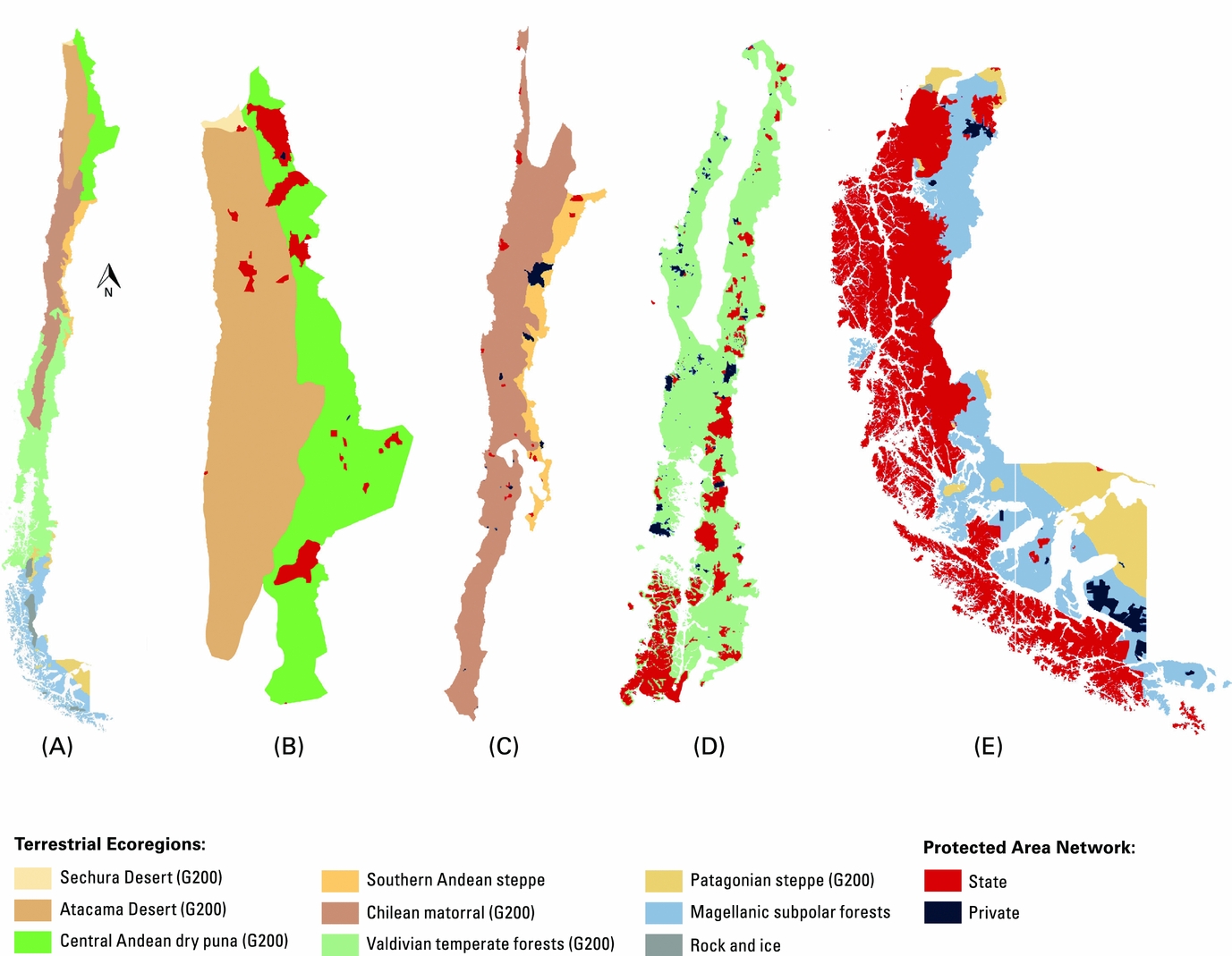
State PAN representation of the Atacama Desert was inadequate (1.35%) (Fig. 1). The Atacama Desert was the ecoregion least protected by NPs, which covered only 0.16%, or 16 408 ha, of the ecoregion. There were no PPAs.
Chilean state and private protected area network ecoregion representation and coverage. Ecoregions of (a) terrestrial Chile, (b) northern Chile, (c) northern central Chile, (d) southern central Chile, and (e) southern Chile.

Central Andean dry puna (G200)
State PAN representation of the dry puna was moderate (11.66%). PPA representation was 0.10%, so representation remained moderate (11.76%) in the IPAN.
Northern central Chile
Chilean matorral (G200 and northern portion of the Central Chile biodiversity hotspot)
State PAN representation of the matorral was inadequate (1.80%). Although the greatest contribution was from NPs, which covered 1.51%, or 223 968 ha, of the ecoregion, only 2.4% of all NPs across Chile were in the matorral. PPA representation was only 0.69%, so representation status remained inadequate (2.49%) in the IPAN. The matorral had the second lowest state and integrated PAN representation after the Atacama Desert.
Southern Andean steppe
State PAN representation of the Andean steppe was inadequate (3.23%). PPA representation was 6.94%, the highest PPA representation in any ecoregion. In the IPAN, representation of the ecoregion was moderate (10.17%). The Andean steppe was the only ecoregion that changed representation status when state and private PAs were combined.
Southern central Chile
Valdivian temperate rainforest (G200 and southern portion of the Central Chile biodiversity hotspot)
The temperate forest was adequately protected by the state PAN (19.69%) and was the only adequately protected G200 in Chile. PPA coverage (572 454 ha) was highest in the temperate forest. IPAN representation was 22.51%. The temperate forest had the second highest state and integrated PAN representations after the subpolar forest.
Southern Chile
Magellanic subpolar forest
The subpolar forest was adequately represented by the state PAN (55.62%) and had the highest representation and coverage of any true ecoregion under both scenarios. The greatest contribution to protection was from NPs, which covered 4.58 Mha and accounted for nearly 50% of Chile's total NP coverage. PPAs contributed another 442 430 ha, the second highest coverage after the temperate forest. PPAs had the second highest representation (3.22%) in the subpolar forest after the southern Andean steppe. Representation of the subpolar forest was 58.83% in the IPAN.
Patagonian steppe (G200)
State PAN representation of the Patagonian steppe was moderate (13.13%) and there were no PPAs.
Rock and ice
Rock and ice is not a true ecoregion, but was treated as such in this study because it is important for conducting comparative analyses of representation and understanding patterns of bias. State and integrated PAN representation was both adequate (97.17%) and greater than the top three most represented ecoregions combined. There were no PPAs.
PAN trends
Scenario 1: State PAN
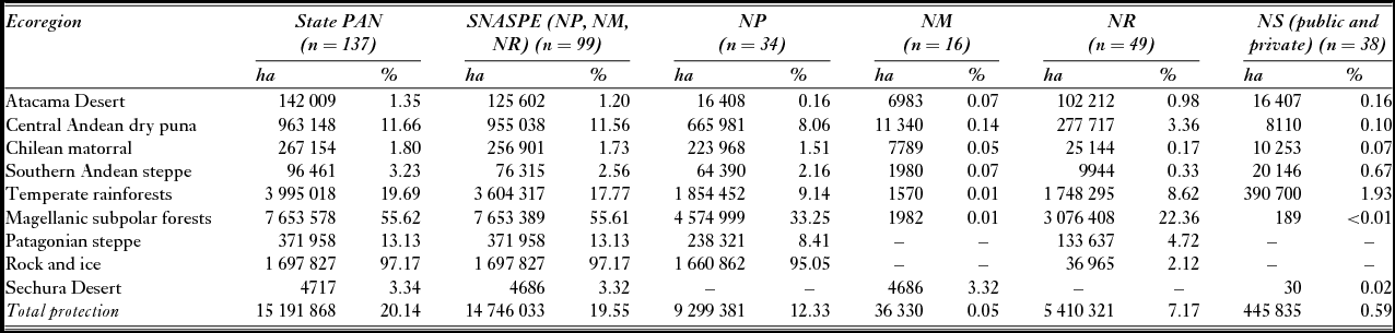
Chile's state PAN protected 20.14%, or 15.19 Mha, of terrestrial Chile (Table 1). NPs provided the most protection by percentage (12.33%) and coverage (9.3 Mha). The state PAN adequately protected rock and ice (97.17%), the subpolar forest (55.62%), and the temperate forest (19.69%), and moderately protected the Patagonian steppe (13.13%) and Central Andean dry puna (11.66%). Meanwhile, protection was almost nonexistent in the matorral (1.80%) and Atacama Desert (1.35%).
Ecoregion coverage (ha) and representation (%) of the state protected area network (PAN) by protected area category. Representation protection designation: 0–9.99% = inadequate; 10–16.99% = moderate; 17–100% = adequate. SNASPE = Sistema Nacional de Áreas Silvestres Protegidas del Estado; NP = national park; NM = natural/national monument; NR = nature reserve; NS = nature sanctuary.

Scenario 2: Integrated PAN
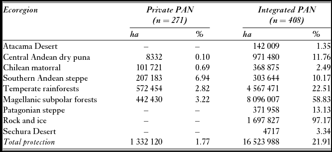
Chile's private PAN protected 1.77%, or 1.33 Mha, of terrestrial Chile (Table 2). Therefore, the IPAN would protect 21.91% of terrestrial Chile. No ecoregion was adequately or moderately protected by the private PAN alone, and there were no PPAs in the G200 Atacama Desert or G200 Patagonian steppe. Integrating private and state PAs only changed the protection status of the southern Andean steppe, which is not a G200, from inadequate to moderate.
Ecoregion coverage (ha) and representation (%) of the private and integrated protected area networks (PANs). Representation protection designation: 0–9.99% = inadequate; 10–16.99% = moderate; 17–100% = adequate.

DISCUSSION
The findings of this study are in agreement with previous research that has shown representation bias is characteristic of national PANs generally and Chile's national PAN specifically. This study found PPAs in Chile did not: (1) meaningfully contribute to achieving Target 11; (2) contribute towards representation goals; or (3) enhance the conservation of PCAs. Two reasons for why PPAs failed to meet expectations is they covered only 1.77%, or 1.33 Mha, of Chile's terrestrial area, compared to the state PAN, which covered 20.14%, or 15.19 Mha, of Chile's terrestrial area. PPAs also exhibited representation bias similar to the state PAN (Corcuera et al. Reference Corcuera, Sepúlveda, Geisse, Pagiola, Bishop and Landell-Mills2002; Durán et al. Reference Durán, Casalegno, Marquet and Gaston2013).
Because the state and private PANs exhibited nearly identical representation bias, the sum of their coverage only served to create a biased IPAN. Only the subpolar and temperate forests met Target 11's minimum representation standard in the IPAN. But these ecoregions already exceeded the minimum standard in the state PAN so PPAs were not necessary to achieve Target 11. The only ecoregion where PPAs enhanced state PAN representativeness was the Andean steppe, where protection status increased from inadequate to moderate. This is the same singular ecoregion Squeo et al. (Reference Squeo, Estévez, Stoll, Gaymer, Letelier and Sierralta2012) found to have enhanced representativeness under an IPAN. Although PPA input in the Andean steppe is meaningful, as all ecoregions need protection, the steppe is not a PCA.
Both state and private PAs had a disproportionally high amount of protection in the temperate and subpolar forest. The WWF has declared the temperate forest a top 25 conservation PCA out of all the G200s (Corcuera et al. Reference Corcuera, Sepúlveda, Geisse, Pagiola, Bishop and Landell-Mills2002), and one of the 35 most critical regions in the world (WWF n.d.b) due to a trend of rich biodiversity, high threat, and low representation (Hoekstra et al. Reference Hoekstra, Boucher, Ricketts and Roberts2005; Nahuelhual et al. Reference Nahuelhual, Carmona, Lara, Echeverría and González2012). The ‘low representation’ charge may have been accurate in the past, but this study found the temperate forest was disproportionally protected when compared to the rest of Chile's ecoregions, especially the G200 Atacama Desert and G200 matorral. The matorral is both one of the most endangered Mediterranean-type ecoregions and the second least protected G200 in the world (Brooks et al. Reference Brooks, Bakarr, Boucher, Da Fonseca, Hilton-Taylor, Hoekstra, Moritz, Olivieri, Parrish, Pressey, Rodrigues, Sechrest, Stattersfield, Strahm and Stuart2004; Coad et al. Reference Coad, Fish, Lysenko, Corrigan, Besancon and Burgess2008; Underwood et al. Reference Underwood, Klausmeyer, Cox, Busby, Morrison and Shaw2008; WWF 2014). Despite these facts, the matorral is not considered one of the WWF's 35 most critical ecoregions. Conservation efforts in the temperate forest should be pursued when it is opportunistic to do so, but resources dedicated to the forest's protection seem more vital to the Atacama Desert and the matorral, which have alarmingly low amounts of protection in the state, private, and integrated PANs.
CONCLUSION
PA assessment is difficult. Measuring the coverage and representativeness of a PAN is not enough to determine if it is effective or complete, nor is measuring a private PAN's contribution to a national PAN a determinate of PPA usefulness or lack thereof. There is much more research to conduct and many more factors to consider than this study has, such as PA management effectiveness (and what counts as effective) (Juffe-Bignoli et al. Reference Juffe-Bignoli, Burgess, Bingham, Belle, de Lima, Deguignet, Bertzky, Milam, Martinez-Lopez, Lewis, Eassom, Wicander, Geldmann, van Soesbergen, Arnell, O'Connor, Park, Shi, Danks, MacSharry and Kingston2014), habitat fragmentation (Carmen Sabatini et al. Reference Carmen Sabatini, Verdiell, Rodríquez Iglesias and Vidal2007), protection of ecosystem services (Durán et al. Reference Durán, Casalegno, Marquet and Gaston2013; SCBD 2014), and susceptibility to external threats (Stolton et al. Reference Stolton, Redford and Dudley2014). There are many roles PPAs may play, in which they may be enormously effective, which should be evaluated as well.
PPAs are an important conservation tool that add to the total area under protection, and are an enticing way of correcting national PAN representation bias in order to meet conservation goals. PPAs not only already exist, they also sidestep government bureaucracy surrounding NPA establishment. However, rather than being viewed as the remedy to national and global representation bias, which is a very demanding request, PPAs may be best suited to small-scale regional or local conservation initiatives that complement, rather than fix, national PANs (Holmes Reference Holmes2013). For instance, PPAs could serve as buffer zones, biological corridors, or connectors that reduce PA fragmentation and enhance ecological processes (Corcuera et al. Reference Corcuera, Sepúlveda, Geisse, Pagiola, Bishop and Landell-Mills2002; Carmen Sabatini et al. Reference Carmen Sabatini, Verdiell, Rodríquez Iglesias and Vidal2007; Dudley Reference Dudley2008; Juffe-Bignoli et al. Reference Juffe-Bignoli, Burgess, Bingham, Belle, de Lima, Deguignet, Bertzky, Milam, Martinez-Lopez, Lewis, Eassom, Wicander, Geldmann, van Soesbergen, Arnell, O'Connor, Park, Shi, Danks, MacSharry and Kingston2014; Stolton et al. Reference Stolton, Redford and Dudley2014). However, this study has made clear that the potential roles of PAs and all PA claims should be based on sound data and timely analysis before initiatives are proposed and implemented.
A fear evolving from the findings of this study is that countries and organizations will continue implementing conservation initiatives based on the lure of PPA effectiveness theories and optimistic speculation. This would divert limited conservation resources from more reliable solutions. As Holmes (Reference Holmes2013: 20) has stated, ‘A rising profile for PPAs may lead to states reducing their investment in PAs, with the expectation the private sector will replace it. [But] PPAs may only protect certain kinds of places and certain forms of biodiversity, and moves towards greater roles for PPAs may leave other areas unprotected.’
The present findings have implications for Chile and the establishment of IPANs around the world. PPAs may very well play a significant role in helping countries meet Target 11, but this must be critically assessed on a country-by-country basis. Other countries can utilize this study's scenario model to compare how well various PA categories represent ecoregions, ecosystem services, species richness, and so on (Scott et al. Reference Scott, Davis, Csuti, Noss, Butterfield, Groves, Anderson, Caicco, D'Erchia, Edwards, Ulliman and Wright1993; Izquierdo & Grau Reference Izquierdo and Grau2009; Durán et al. Reference Durán, Casalegno, Marquet and Gaston2013). Only by determining the actual, not theoretical, role various PA types may play in meeting local, national, and international conservation goals will countries and the conservation community find new solutions to stopping biodiversity loss, proportionally representing the world's biodiversity, and protecting PCAs in perpetuity.
ACKNOWLEDGEMENTS
I would like to thank Keith Bosak and Sarah Halvorson of the University of Montana for providing guidance and invaluable feedback during the proposal, research, and editing phase of this study. I would also like to thank Diep Dao of the University of Montana, Aníbal Pauchard of La Universidad de Concepción, Chile, and George Holmes of The University of Leeds, UK, for sharing their knowledge and resources and for their technological assistance, insightful comments, and help navigating Chile.
FINANCIAL SUPPORT
This research was supported in part by the Alaback and Brewer Melipal Fellowship, University of Montana, MT, USA.
CONFLICT OF INTEREST
None.
ETHICAL STANDARDS
None.