Introduction
Mangroves are an arboreal-shrub vegetation that develops mainly over muddy soils of tropical and subtropical rivers throughout the intertidal zone (Maia et al., Reference Maia, Lacerda, Monteiro and Souza2005). These ecological attributes enable mangroves to serve as natural nurseries that provide protection, and both feeding and breeding grounds for different species. Therefore, this ecosystem is responsible for the balance and maintenance of natural resources in coastal areas (Copque et al., Reference Copque, Cunha and Souza2010).
Among the species that use this environment, the Antillean manatee (Trichechus manatus) inhabits coastal and estuarine areas due to the availability of food resources and warm, shallow waters, serving as refuges with sources of fresh water (Lima et al., Reference Lima, Paludo, Soavinski, Silva and Oliveira2011). However, the integrity of these environments is highly threatened due to suppression of mangroves, silting, pollution of water resources and reduction in river flow (Alves, Reference Alves2001), especially in the north-eastern region of Brazil, placing environmental pressure on mangrove ecosystems and the species that use these resources (Maia et al., Reference Maia, Lacerda, Monteiro and Souza2005).
In recent decades, studies have reported that the impacts on estuarine environments have led to an increase in the number of stranded Antillean manatee calves in north-eastern Brazil (Parente et al., Reference Parente, Vergara-Parente and Lima2004; Meirelles, Reference Meirelles2008; AQUASIS, 2016), considered one of the main threats to the species in the country (Parente et al., Reference Parente, Vergara-Parente and Lima2004; Lima et al., Reference Lima, Paludo, Soavinski, Silva and Oliveira2011). Understanding these stranding events is considered a priority in the National Action Plan for the Conservation of West Indian Manatees (Decree No. 249, 4 April 2018), as highlighted in the section calling for the ‘Assessment of the expansion and retraction dynamics of mangrove forest over the years to assist in the conservation of the species’ (ICMBio, 2018a).
Paraíba is one of the main areas of occurrence of the Antillean manatee in Brazil (Lima et al., Reference Lima, Paludo, Soavinski, Silva and Oliveira2011). The state has important mangrove forests, especially those found in federal protected areas, such as the Area of Relevant Ecological Interest (AREI) Mangroves of the Mamanguape River created by Federal Decree no. 91.890 of 5 November 1985 (Brasil, 1985), the Mamanguape River Environmental Protection Area (EPA) created by Federal Decree no. 924 of 10 September 1993 (Brasil, 1993), the Restinga de Cabedelo National Forest (NATFOR) created by Federal Decree of 2 June 2004 (Brasil, 2004) and the Acaú-Goiana Extractive Reserve (EXTRES) created by Federal Decree of 26 September 2007 (Brasil, 2007). According to these decrees, the purpose of the creation of these conservation units, in some cases, was to ensure the conservation of the manatee, estuaries and mangrove communities.
According to federal legislation in Brazil, mangroves are permanent preservation areas (Brasil, 2012) and manatees are classified as endangered (ICMBio, 2018b). Despite the recognized importance and ecological attributes of mangroves, little mapping has been performed for these ecosystems (Santos, Reference Santos2011; ICMBio, 2018c). Regarding the Antillean manatee, studies with inferences that relate stranding events to habitat loss are scarce. To fill these gaps in the existing information, geotechnologies constitute powerful tools that can be used to analyse geographic space through computational techniques combined with cartography, photogrammetry, remote sensing, geoprocessing and geographic information systems (Santos et al., Reference Santos, Ribeiro, Peluzio, Peluzio, Santos, Moreira and Magalhães2015). Geographic information systems allow a comprehensive analysis of the components of a landscape, integration of existing biotic and abiotic components, management of natural resources and future simulations through the combination of events of probable occurrence (Silveira, Reference Silveira2005). As mangroves are increasingly exposed to the effects of drastic changes to coastal landscapes (Prates et al., Reference Prates, Gonçalves and Rosa2012), the aim of the present study was to analyse and quantify the spatiotemporal dynamics of mangroves in the state of Paraíba and investigate the association with stranding events involving Antillean manatee calves.
Materials and methods
Study area
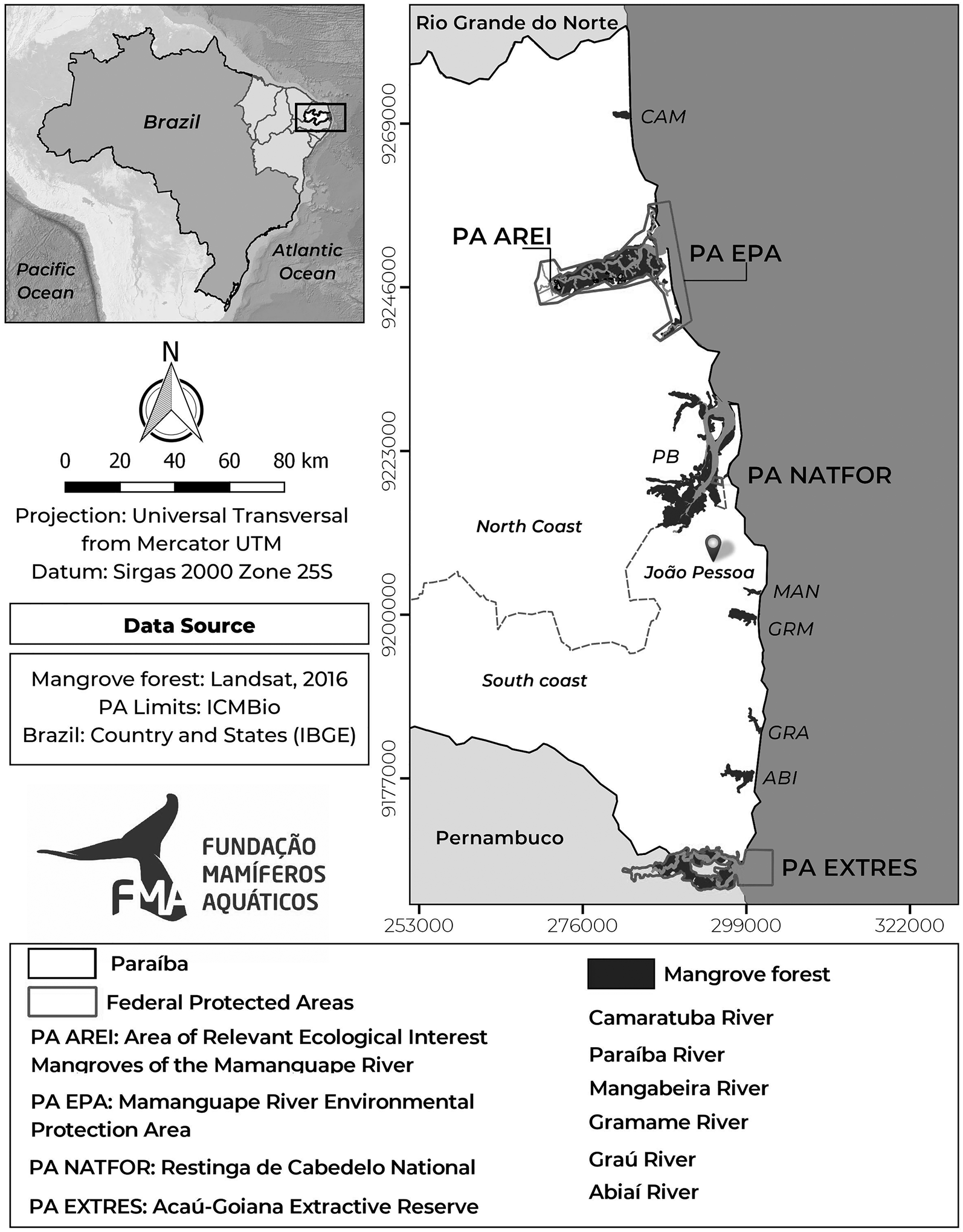
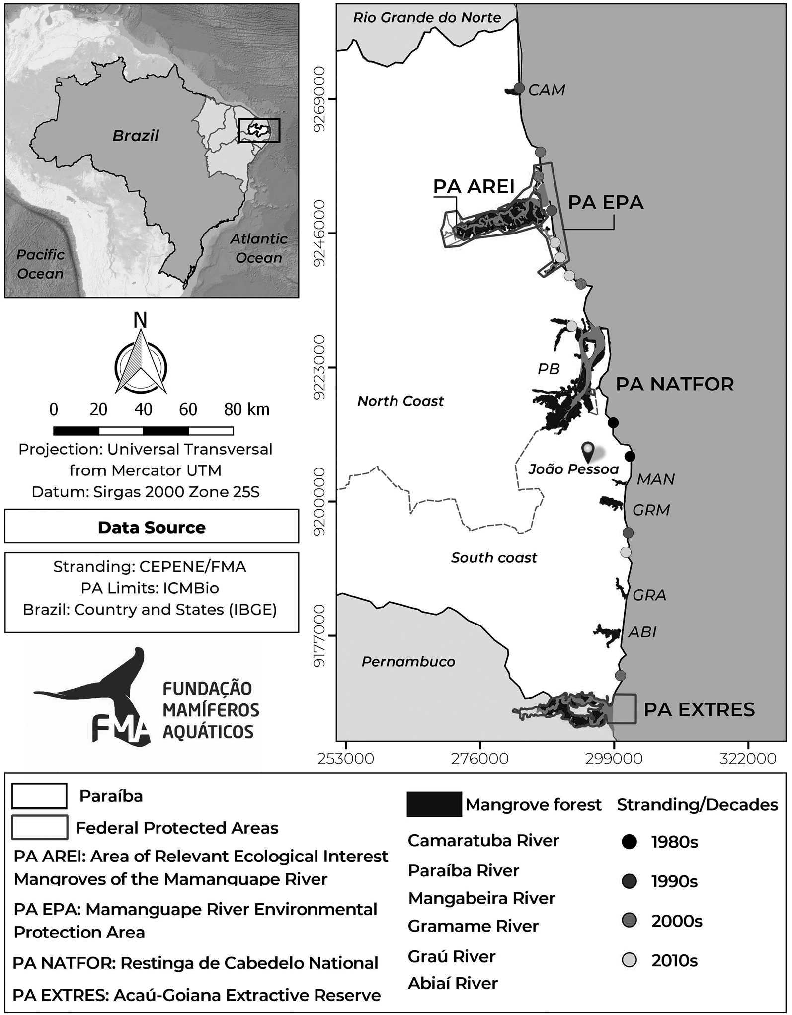
The study area encompassed 10 remaining mangrove forests distributed along the coast of the state of Paraíba (north-eastern Brazil): two located on the northern coast and eight on the southern coast. Four of these mangrove forests are located in federal protected areas (PAs): Area of Relevant Ecological Interest (AREI) Mangroves of the Mamanguape River; Mamanguape River Environmental Protection Area (EPA); Restinga de Cabedelo National Forest (NATFOR); and Acaú-Goiana Extractive Reserve (EXTRES) (Figure 1). These PAs were chosen for their contribution to the conservation of mangroves and for being considered areas of occurrence of manatees. The other mangrove forests were located around the estuaries of the Camaratuba River (CAM) to the north and the Paraíba (PB), Mangabeira (MAN), Gramame (GRM), Graú (GRA) and Abiaí (ABI) rivers to the south.
Mangrove forests distributed along the coast of Paraíba, north-eastern Brazil.

Acquisition, processing of satellite images and quantification of mapping
A historical series was used spanning four decades (1980s, 1990s, 2000s and 2010s). Satellite images in this period that met the following criteria were selected: spatial resolution of 30 m, little cloud cover and corresponding to the months of August to April (dry season; period of low rainfall) (Araújo et al., Reference Araújo, Silva, Alencar, Santos, Santos, Almeida and Silva2016). The images were acquired from the electronic site of the United States Geological Survey (USGS, 2020). After the selection of the satellite images following the predefined criteria, images from 1985, 1995, 2005 and 2016 were chosen (Table 1).
Information on images used for spatiotemporal mapping

To obtain more satisfactory results, a pre-processing step was performed, which consisted of the re-projection of the images to the southern hemisphere and Datum SIRGAS 2000 as well as the spectral composition using Bands 3, 4 and 5, as this composition of bands highlights mangrove vegetation, ensuring a more precise result (Boulhosa & Souza Filho, Reference Boulhosa and Souza Filho2009).
A supervised classification of the images was then performed, with discrimination of the targets (mangrove forests) using the maximum likelihood method (Crósta, Reference Crósta2002). These procedures were performed with the aid of ArcGIS 10.3.0 software (ESRI, 2014).
To identify changes (expansion and/or reduction) in the area corresponding to mangrove forests over the years, calculations were performed for each mangrove forest using ArcGIS 10.3.0 (ESRI, 2014) to obtain the total area in hectares.
Records of manatee stranding events
Stranding data were obtained from a pre-existing databank from institutions that work with stranding events: Fundação Mamíferos Aquáticos (FMA (Aquatic Mammal Foundation)), Centro Nacional de Pesquisa e Conservação de Mamíferos Aquáticos (CMA (National Aquatic Mammal Research and Conservation Center)), and Centro Nacional de Pesquisa e Conservação da Biodiversidade Marinha do Nordeste (CEPENE (National Research and Conservation Center for Marine Biodiversity of the Northeast)). The timeframe was 1980–2019. In the present study, only manatees characterized as calves were considered, with average length of 123 cm and 34 kg of weight for newborn (Borges et al., Reference Borges, Freire, Attademo, Serrano, Anzolin, Carvalho and Vergara-Parente2012). Information was compiled on the date, location and geographic coordinates of each stranded manatee calf.
Data analysis
Bar graphs were used to quantify the distribution of stranded manatee calves along the northern and southern coasts of the state of Paraíba. Logistic regression analysis was used to test the hypothesis that the probability of manatee stranding (inferred as 0 and 1) increased over the years. To determine the frequency of stranding events over the years, a logistic regression (stranding events ~ years) was performed using R software (2018, version 3.5.0). A combination graph was created using Excel software to analyse the possible association between the change in mangrove area (retraction or expansion) and the frequency (presence or absence) of manatee stranding events over the decades studied.
Results
Mangrove forests of Paraíba
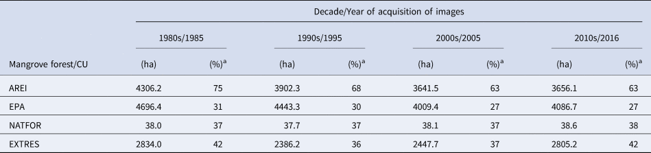
The first PA analysed was the AREI Mangroves of the Mamanguape River, which had its largest area in the 1980s (Table 2). In the following periods (1990s and 2000s), contraction of the mangrove forests occurred, followed by a slight increase in the most recent decade (2010s) by comparison to the previous decade (2000s), characterizing a slight expansion in mangrove coverage but still far below the coverage reported for the 1980s.
Mangrove forests in protected areas in Paraíba

a Percentage of mangrove forest in relation to total area of the protected area.
The same pattern was found in the Mamanguape River Environmental Protection Area (EPA), with contraction in mangrove area after the 1980s and a slight expansion only in the most recent decade (2010s). It should be pointed out that the EPA overlaps some of the boundaries of the AREI.
The Restinga de Cabedelo NATFOR underwent a small change in the area of mangrove forests throughout the period studied, with a slight increase in the most recent decade compared with its initial area. These findings reveal that mangrove forests in this PA remained more conserved and stable.
The Acaú-Goiana EXTRES had its largest area of mangrove forests in the 1980s, followed by a reduction. However, considerable expansion occurred in the 2000s and 2010s, with the area of mangrove coverage approaching that found in the initial period of the present study (Table 2).
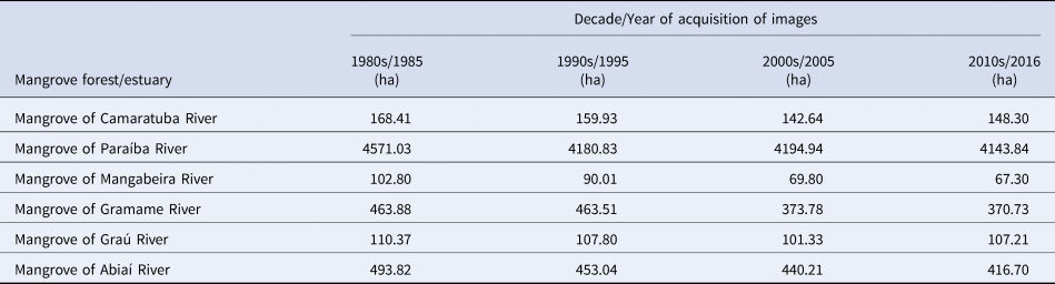
Besides the mangrove forests in the federal protected areas on the coast of Paraíba, the present study evaluated six additional mangrove areas distributed around the estuaries of rivers along the coast. The areas of these mangrove forests throughout the decades analysed are displayed in Table 3.
Extension of mangrove forests of state of Paraíba over time (1980s–2010s)

Records of manatee stranding events in state of Paraíba
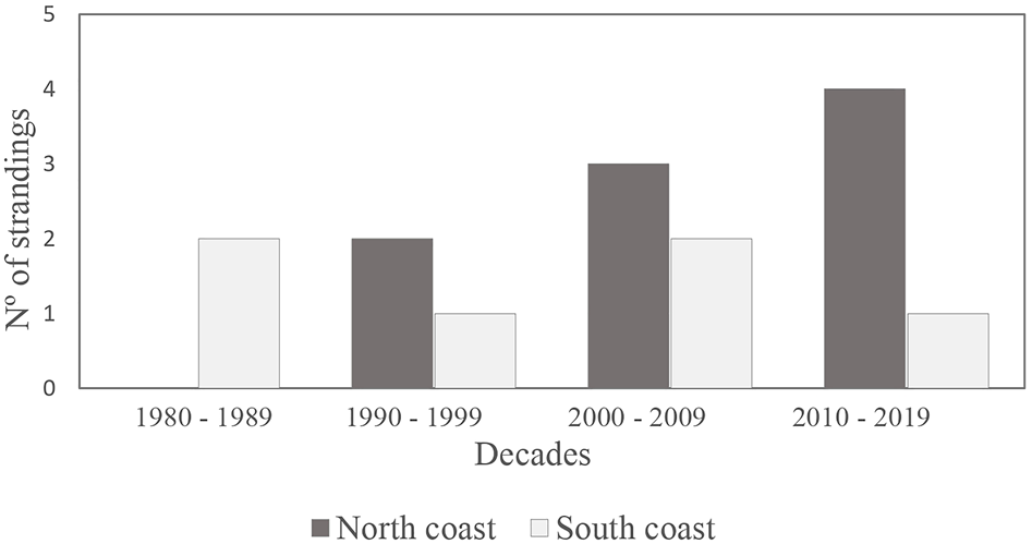
Fifteen stranding events involving manatee calves were recorded between 1980 and 2019 in Paraíba. Analysing the data per decade, an increase in the number of stranding events occurred on both the northern and southern coasts, with a greater increase on the northern coast.
Two stranding events occurred in the first decade, both of which were on the southern coast. In the second decade, an increase in the number of stranding events occurred, with two on the northern coast and only one on the southern coast. Another increase occurred in the third decade, with three stranding events recorded on the northern coast and two on the southern coast. In the last decade, the number of stranding events increased on the northern coast to four, whereas only one event was recorded on the southern coast (Figure 2).
Number of stranding events on northern and southern coast of state of Paraíba in four decades.

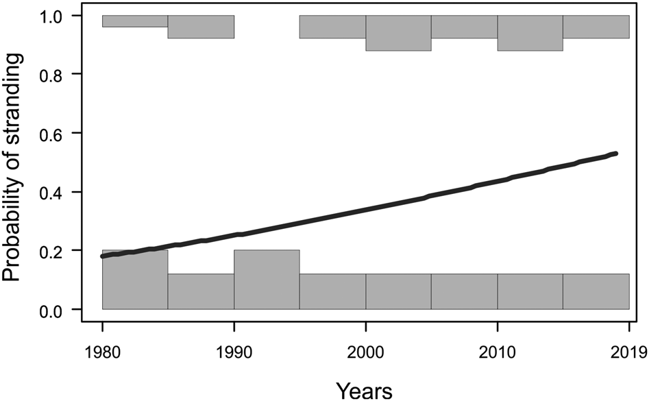
The data on stranded manatee calves for the entire state of Paraíba show a tendency toward an increase in the probability of stranding events over the years (logistic regression: χ2 = 1.435, df = 42, P = 0.151), revealing a positive, non-significant association (Figure 3).
Probability of stranding of manatee calves between 1980 and 2019 in the state of Paraíba.

Integrated analysis (mangrove forests and stranding events)
The spatial analysis of the data revealed that 12 of the 15 stranding records occurred on beaches, whereas only three occurred within estuaries. Moreover, a greater number of stranding events occurred within the limits or in the proximity of the Mamanguape River EPA and the AREI Mangroves of the Mamanguape River compared with the other PAs (Restinga de Cabedelo National Forest and Acaú-Goiana Extractive Reserve). The stranding events related to the latter two PAs occurred in the proximity of these areas; none occurred within the PAs (Figure 4).
Distribution of stranded manatee calves on coast of Paraíba, 1980–2019.

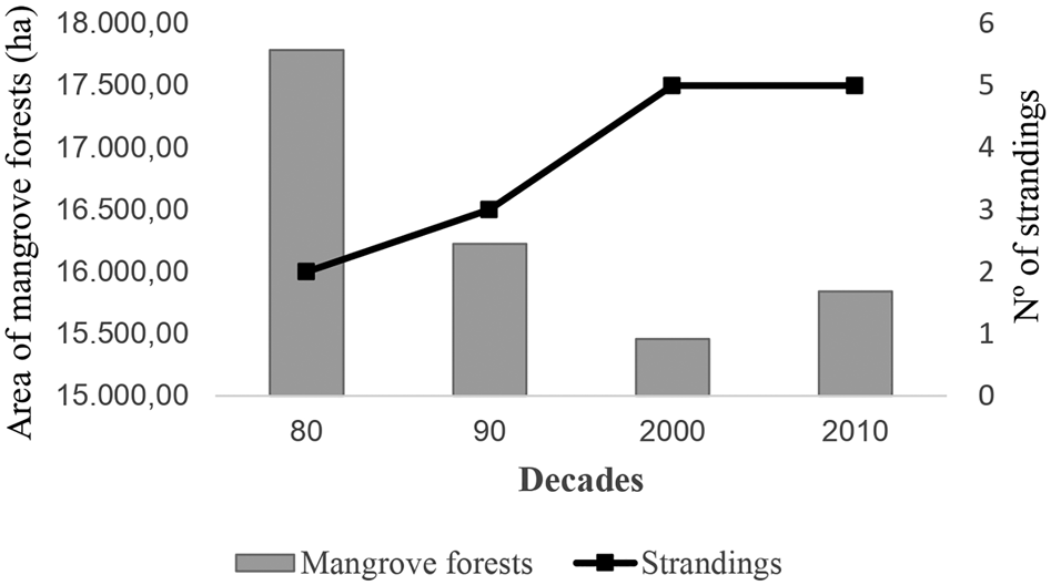
Relating the mangrove coverage to manatee calf stranding events for the entire state of Paraíba, a tendency was found toward an increase in the number of stranding events with the reduction in the area of the mangrove forests, revealing an inverse relationship between the two variables (Figure 4).
In the 1980s, the mangrove forests analysed covered a total of 17,784.91 ha and two stranded manatee calves were recorded. In the 1990s, the mangrove area corresponded to 16,224.62 ha, with the occurrence of three stranding events. In the 2000s, mangroves covered 15,459.40 hectares, and corresponded to 15,840.68 ha in the most recent decade (2010s), with five records of stranding events in each of these decades (Figure 5).
Association between area of mangrove forests and stranding events involving manatee calves in state of Paraíba over four decades.

Discussion
The largest mangrove areas were documented in the 1980s among nine of the 10 mangrove forests analysed in the present study, followed by reductions in subsequent years. Surveys conducted in the 1980s and 1990s revealed reductions in mangrove areas in some states of north-eastern Brazil, especially Ceará (−24%), Piauí (−8%) and Paraíba (−5%) (Lacerda et al., Reference Lacerda, Maia, Monteiro, Souza, Bezerra and Menezes2006). Even more concerning, estimates indicate that ~25% of the mangroves in Brazil have been destroyed since the beginning of the 20th century (ICMBio, 2018c), corresponding to a reduction of ~100,000 hectares (FAO, 2007; MMA, 2010).
NATFOR was the only location not to follow the same pattern as the other mangrove forests analysed, exhibiting its largest area in the most recent decade (2010s). The changes (expansion or retraction) in area of mangroves in this protected area were of the order of only 1% over the four decades analysed (1980 through 2019), which may indicate both the regeneration of plant cover and common technical, atmospheric or natural variations in the satellite image classification process. Such variations are related to the quantity and form of water available in the environment. Liquid water (represented in this study by rivers and the dynamics of the tide) presents high energy absorption and clouds have high reflectance, which interferes with the mapping results (IBGE, 2001; Santos, Reference Santos2011).
Six mangrove forests exhibited an expansion in area in the most recent decade (2010s), four of which are located within federal protected areas (AREI, EPA, NATFOR and EXTRES), and one corresponds to the mangrove around the Graú River, which is situated in the Tambaba Environmental Protection Area created in 2002 by State Decree no. 22.882 of 25 March 2002 (Paraíba, 2002). This expansion may be linked to the establishment of the protected areas. Although there is no specific legislation for mangroves, the establishment of protected areas has contributed to the conservation of these ecosystems (ICMBio, 2018c).
Another hypothesis raised to explain the increase in mangrove area is the development of mangrove vegetation in new areas further inland resulting from the generalized salinization of estuaries in north-eastern Brazil (Santana et al., Reference Santana, Galvíncio, Torres, Passos, Silva, Silva, Cavalcanti, Teixeira, Paz, Silva and Lira2011; Bezerra, Reference Bezerra2014). Moreover, the north-eastern region is affected by the increase in sea level (Belchior & Salazar Primo, Reference Belchior, Salazar Primo, Araújo, Belchior and Viegas2016), resulting in changes along the coastline due to erosive processes (Neves, Reference Neves2003; Neves et al., Reference Neves, Dominguez, Bittencourt and Muehe2006; Reis, Reference Reis2008). However, mangroves have the capacity to tolerate moderate changes in average sea level (Alongi, Reference Alongi2008), enabling the migration of forests more inland (Schaeffer-Novelli et al., Reference Schaeffer-Novelli, Cintrón-Molero, Soares, Healy, Yang and Healy2002; Soares, Reference Soares2009). Thus, the fringes of estuaries and the apicuns may be most affected, as they suffer the impact more directly, leading to retraction, and the swamps can become occupied by mangrove vegetation, leading to the replacement of this feature with mangrove forests (ICMBio, 2018c).
In the period studied, the lowest number of stranding events occurred in the 1980s and the highest number occurred in the 2010s. Paraíba is the third state of north-eastern Brazil in number of stranded manatees (Balensiefer et al., Reference Balensiefer, Attademo, Sousa, Freire, Cunha, Alencar A, Silva and Luna2017), with such events most often involving calves (Parente et al., Reference Parente, Vergara-Parente and Lima2004; Meirelles, Reference Meirelles2008; Balensiefer et al., Reference Balensiefer, Attademo, Sousa, Freire, Cunha, Alencar A, Silva and Luna2017).
A higher number of stranding events occurred on the northern coast of the state, especially in the region responding to the Mamanguape River EPA. This may be explained by the fact that this region is considered one of the locations with the greatest occurrence of manatees in north-eastern Brazil (Silva et al., Reference Silva, Paludo, Oliveira, Lima and Soavinski2011; Alves et al., Reference Alves, Schwamborn, Borges, Marmontel, Costa, Schettini and Araújo2013, Reference Alves, Kinas, Marmontel, Borges, Costa, Schiel and Araújo2015) due to ecological attributes that favour the occurrence of the species, such as an estuarine environment (Luna et al., Reference Luna, Araújo, Passavante, Mendes, Pessanha, Soavinski and Oliveira2008).
Nearly all stranding events occurred in areas of exposed beaches without the protection of coral reefs or estuaries. In such situations, the access of females to protected locations may become restricted due to the fact that estuarine and beach environments of Paraíba are undergoing build-up of sediments, leading to silted areas (Neves et al., Reference Neves, Dominguez, Bittencourt and Muehe2006) or increase in boat traffic that can cause behavioural changes that lead the animals to leave important feeding and resting areas, or separate females from their calves (Meirelles et al., Reference Meirelles, Carvalho and Silva2014). Thus, females may find it difficult to access estuaries and may be forced to perform parental care in other areas along the coast, including open areas. Indeed, Lima et al. (Reference Lima, Paludo, Soavinski, Silva and Oliveira2011) reported that rescued calves were found in unprotected beaches and were in good physical condition. The authors suggest that females that do not find a safe refuge for birth and parental care face hardship in the first days following the birth of their calves, maintaining them under non-ideal conditions (exposed areas), often leading to separation from the calf.
The present findings and the hypothesis raised by Lima et al. (Reference Lima, Paludo, Soavinski, Silva and Oliveira2011) and Choi (Reference Choi2011) suggest that stranding events are often due to the lack of a sheltered location for birth and subsequent parental care necessary for post-parturition bonding. Similar descriptions have been reported by Hartman (1979), noting that when a female manatee is reaching the end of the pregnancy, it starts looking for shallow and sheltered waters to give birth and care for the calf, which is born completely vulnerable. The environmental pressures in these estuaries lead pregnant or lactating females to use more open areas, which are subject to increased wave action and currents, thereby increasing the possibility of dependent calves becoming stranded on beaches (Meirelles, Reference Meirelles2008).
The degradation of environments historically used by manatees on the eastern coast of the state of Ceará (north-eastern Brazil) was reported to be one of the factors explaining the number of calves stranded between 1987 and 2002 (Meirelles, Reference Meirelles2008). This statement confirms data reported by Balensiefer et al. (Reference Balensiefer, Attademo, Sousa, Freire, Cunha, Alencar A, Silva and Luna2017), who found that a large portion of stranded calves did not exhibit any disease and were specimens found with vestiges of the umbilical cord and tail folds, characteristic of newborn calves.
In the present temporal analysis, a smaller number of stranding events occurred when the areas of mangroves were larger, which confirms the importance of these environments protected by reefs and with mild currents during periods of parturition, care for the calf and feeding of newborns. By contrast, the reduction in mangrove areas was associated with a tendency toward an increase in the number of stranding events. Similar findings were reported in newborn strandings events on Ceará and Rio Grande do Norte states (north-eastern coast), where estuaries had significant loss of mangrove forests to salines and/or shrimp farms (Choi, Reference Choi2011; AQUASIS, 2016). The ecological importance of these estuarine resources was highlighted by Alves et al. (Reference Alves, Schwamborn, Borges, Marmontel, Costa, Schettini and Araújo2013), who reported that these preserved environments favour the presence of manatees. The degradation of these favoured environments directly affects mother–calf interactions (Lima et al., Reference Lima, Alvitre, Reid and Bombassaro2012), possibly leading to calf stranding events. In addition to habitat degradation, other factors may be acting synergistically to cause calf strandings, such as the recruitment of young females and/or females with bad experiences and loss of maternal ability caused by inbreeding (AQUASIS, 2016).
The present study revealed the importance of intact mangroves to the maintenance of manatee populations, enabling adult females to have a sheltered location in order to provide care for their newborn calves and reducing the risk of separation. The establishment of protected areas in estuarine regions with the presence of mangroves has contributed to the maintenance and occasional expansion of submerged vegetative coverage, breeding, resting habitat (Silva et al., Reference Silva, Paludo, Oliveira, Lima and Soavinski2011) and supplement for fresh water (Allen et al., Reference Allen, Beck, Bonde, Powell and Gomez2018). As this ecosystem is considered a natural nursery for a number of species, the creation of new protected areas should be encouraged, increasing conservation efforts directed at protecting endangered species, such as the Antillean manatee.
Acknowledgements
The authors are grateful to the Programa de Pós-Graduação em Ecologia e Monitoramento Ambiental – Universidade Feral da Paraíba (Postgraduate Program in Ecology and Environmental Monitoring), Fundação Mamíferos Aquáticos (Aquatic Mammal Foundation), Laboratório de Cartografia e Geoprocessamento (Cartography and Geoprocessing Lab-UFPB), Environmental Protection Area of the Mamanguape River/ICMBio, Centro Nacional de Pesquisa e Conservação da Biodiversidade Marinha do Nordeste/ICMBio (National Research and Conservation Center for Marine Biodiversity of the Northeast), Centro Nacional de Pesquisa e Conservação de Mamíferos Aquáticos/ICMBio (National Aquatic Mammal Research and Conservation Center), Projeto Viva o Peixe-Boi Marinho of the Fundação Mamíferos Aquáticos and sponsored by Petrobras through the Petrobras Socioenvironmental Program and the Manatee Conservation Program of the Fundação Mamíferos Aquáticos in partnership with the Fundação Grupo Boticário de Conservação à Natureza (Boticário Group Foundation for the Conservation of Nature). Rebelo VA thanks CAPES for the master's degree scholarship. We thank Dr Peter Evans and anonymous reviewers for critical comments on the manuscript.