Introduction
In McMurdo Sound, Antarctica, the benthic communities in shallow water less than 30 m deep have been well described (Cummings et al., Reference Cummings, Hewitt, Thrush, Marriott, Halliday and Norkko2018). The deeper communities between 30 and 600 m, the maximum depth of the sound, have been described more generally (Dearborn, Reference Dearborn1965; Reference Dearborn1967). At depths over 30 m, sponges, soft corals and bryozoans dominated (Dearborn, Reference Dearborn1965; Reference Dearborn1967; Szuta, Reference Szuta2017). In addition to these dominant filter-feeding taxa, predatory species were present. Communities are persistent over decades; however, episodic recruitment events can change the constituents significantly (Dayton, Reference Dayton1989; Dayton et al., Reference Dayton, Jarrell, Kim, Thrush, Hammerstrom, Slattery and Parnell2016).
Ice is an important physical factor that controls Antarctic ecosystems (Gutt, Reference Gutt2001); both iceberg and sea ice patterns can potentially influence episodic community change (Dayton et al., Reference Dayton, Jarrell, Kim, Thrush, Hammerstrom, Slattery and Parnell2016). Sea floor disturbance by icebergs can decimate benthic communities, leaving ample space for new colonisation (Kim & Collins, Reference Kim and Collins2021). Sea ice coverage and persistence change food availability (Arrigo & vanDijken, Reference Arrigo and van Dijken2003) with long-term consequences to the benthos (Conlan, Kim, Thurber, & Hendrycks, Reference Conlan, Kim, Thurber and Hendrycks2010).
Ice also controls community zonation with depth in the McMurdo Sound region of Antarctica, via disturbance by anchor ice (Dayton, Robilliard, & Paine, Reference Dayton, Robilliard and Paine1970). Depth zonation is not uncommon in marine habitats, though the underlying causal factor is generally not depth per se (Connell, Reference Connell, Cody and Diamond1975; Menge, Reference Menge2000). For example, at seamounts, the change in current flow induced by the rapid bathymetric decrease alters food and larval availability resulting in a different community on the top compared to the surrounding sea floor (Rogers, Reference Rogers2018).
The bathymetry of seasonally ice-covered seas in the Antarctic is poorly known. Even in close proximity to major research facilities such as McMurdo Station and supporting ship traffic, the bathymetry of the sea floor remains only roughly defined. The best available overall map of McMurdo Sound is a digital elevation model with 50 m bathymetric contours (https://www.gmrt.org/GMRTMapTool/). Though this is a very useful resource, spot groundtruthing shows it is unfortunately inaccurate on close examination (personal observation). More detailed bathymetry is available along the ship track used when accessing McMurdo Station (https://www.ncei.noaa.gov/maps/bathymetry/), but it is quite spatially limited.
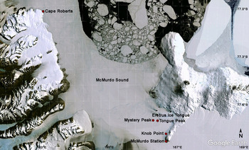
Incidental to other research efforts, detailed bathymetric information is available for other locations, but the coverage is unsystematic due to the varied drivers of diverse scientific goals. In 2010, Craig Stevens documented a bathymetric high on the sea floor west of the Erebus Glacier Tongue in McMurdo Sound (Mystery Peak, 77° 43.111’ S 166° 16.411’ E, Fig. 1). The general sea floor depth in this area is 300 m (Stevens et al., Reference Stevens, McPhee, Forrest, Leonard, Stanton and Haskell2014), and the peak rises to approximately 35–40 m. Nearby (77° 42.635’ S 166° 14.782’ E), magnetic mapping by Lee Fuiman and Erin Frolli in 2014 suggested a second bathymetric high (Tongue Peak). These sea floor peaks reflect the surrounding land topography, which displays cinder cones and other volcanic landforms (Wright, Reference Wright1980). Neither is shown on available bathymetric maps of the area.
Map of the study area in McMurdo Sound, Antarctica.

We describe the benthic communities on two previously unknown bathymetric highs in McMurdo Sound, Antarctica. Community differences with depth, time and disturbance regime are explored. To collect data, we took advantage of the testing of time-lapse camera systems suitable for polar work beneath a fixed ice surface. Research under ice-covered seas is challenging and costly because of the difficulties in accessing the liquid ocean. To make collections or emplace tools, a hole must be made through the ice of a size suitable for the needed equipment. Research divers have been working in this area since the early 1960s (Brueggeman, Reference Brueggeman2003), but they require a large hole 1.5 m in diameter and are limited in the depths they can reach to 40 m. Recently, expanding technological applications have increased scientific opportunities by creation of new tools suitable for use in the Antarctic (sensu Cazenave, Zook, Carroll, Flagg, & Kim, Reference Cazenave, Zook, Carroll, Flagg and Kim2011). The smaller holes required for deployment (e.g. 0.25 m) and ability to reach greater depths (e.g. 300 m) have greatly enlarged the potential research area.
Materials and methods
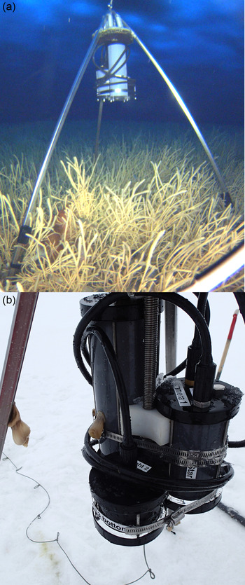
The 35–40 m depth of the top of Mystery Peak is just within the range of scientific scuba divers and was visited in 2012 by divers with cameras to provide an initial description of the benthic community. At Tongue Peak, we confirmed a water depth of 70 m. In 2014, autonomous time-lapse camera systems called SeeStar (Cazenave, Kecy, Risi, & Haddock, Reference Cazenave, Kecy, Risi and Haddock2014) were deployed for two months (28/31 October 2014 to 7 January 2015) at both peaks (Fig. 2). Each recorded an area of 1 × 1.3 m in a 12-megapixel image every 15 min. The SeeStar deployed at Mystery Peak was knocked over by the strong currents after nine days.
The time-lapse camera system SeeStar in the Antarctic. (a). SeeStar deployed on the seafloor at Mystery Peak, over a field of the sponge Homaxinella balfourensis. Image taken by the ROV SCINI (Cazenave et al. Reference Cazenave, Zook, Carroll, Flagg and Kim2011). (b). Details of SeeStar on recovery; notice the two Artemidactis victrix anemones hanging off the electronics module and the frame.

The SeeStar system was specially modified for Antarctic use in two ways. Batteries were upgraded for extended use in low temperatures. A tripod that would mount all components and still fit down a 25-cm hole through the sea ice was constructed. The tripod mechanically unfolded on deployment and refolded on recovery.
A remotely operated vehicle (ROV) SCINI (Cazenave et al., Reference Cazenave, Zook, Carroll, Flagg and Kim2011) was used to visualise SeeStar on the sea floor at Mystery Peak. The ROV also provided fortuitous imagery of an iceberg scour that occurred between the diver visits in October 2012 and deployment in October 2014, as well as other changes that had happened over the preceding two years.
To determine abundances, images were processed in PhotoQuad with 100 stratified random points per image. Organisms were identified to the lowest possible taxon using primarily Peter Brueggeman’s Underwater Field Guide to Ross Island & McMurdo Sound, Antarctica (Brueggeman, Reference Brueggeman1998). Commonly, bryozoans and hydroids occurred mixed together in a tangled mat, could not be identified to species or even differentiated with certainty, and were placed into an “operational taxonomic unit” (OTU) of Hydroidea/Bryozoa.
Each image count was rectified to area as appropriate. In SeeStar images, the area was consistently 1.3 m2. Images taken with the ROV SCINI incorporated scaling lasers that were 10 cm apart, and individual images varied in area (0.09–0.43 m2). Images collected by scuba divers also incorporated scaling lasers plus a crossing laser that maintained image area at close to 2 m2.
Results
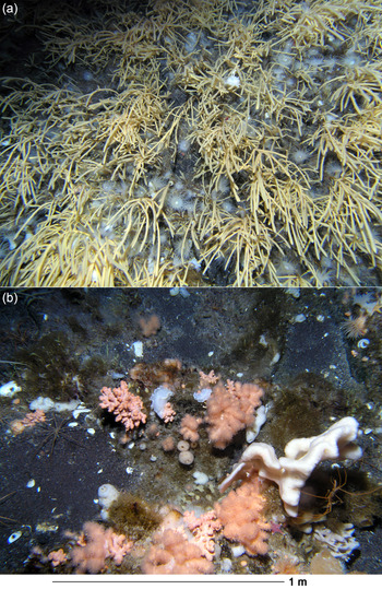
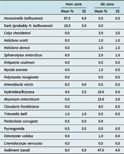
Mystery Peak was capped by a dense community strongly dominated by the sponge Homaxinella balfourensis in 2012 (Table 1, Fig. 3). The anemone Artemidactis victrix was also abundant. Species richness was low, at six species, though there were probably many more species hidden within the thick H. balfourensis thicket. This community was only on the very top of the peak, which covered an area of approximately 1000 m2 but was within a depth range of just a few metres (36–39 m). Immediately below the peak (water depth 40 m) the community was much more diverse, with a species richness of 16 within the same area. The community there was dominated by the gorgonian Alcyonium antarcticum, hydroids/bryozoans, and the anemone Clavularia frankliniana, as well as a mixture of sponge species. Species found in both communities included H. balfourensis, A. victrix, and hydroids/bryozoans, as well as the nudibranch Tritoniella belli and pycnogonids. The exposed sediment in both areas was coarse sand.
Example images from the two zones on Mystery Peak in 2012, (a). Homaxinella-dominated, and (b). Alcyonium-dominated.

Percent cover of species in still images taken by divers at Mystery Peak in 2012. Mean and standard error (SE), n = 2 in each zone, Hom = Homaxinella-dominated and Alc = Alcyonium-dominated. Area of each image was approximately 2 m2.

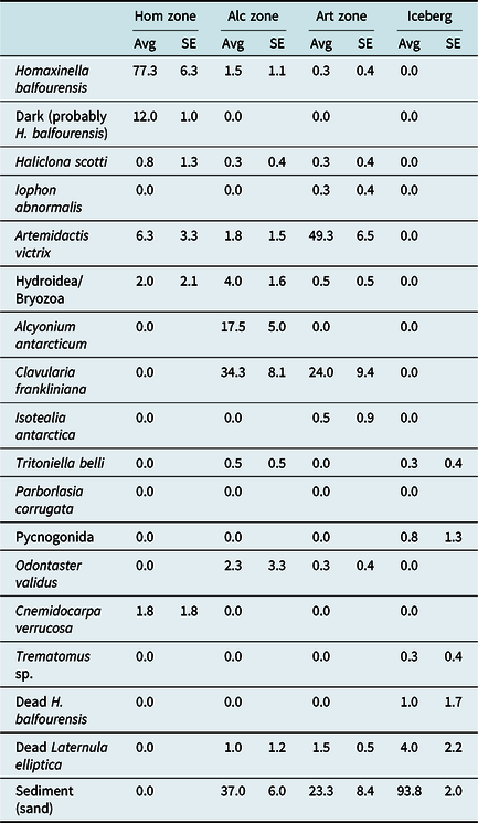
In 2014, the community that capped Mystery Peak had not changed a great deal; in the Homaxinella balfourensis zone, the sponges covered more of the sediment, which had been bare in 2012 (Table 2). In the Alcyonium antarcticum zone, sponge diversity was lower, and cover of hydroids/bryozoans had decreased while Clavularia frankliniana cover had increased.
Percent cover of species in still images taken by ROV SCINI at Mystery Peak in 2014. Average and standard error, n = 4 in each zone, Hom =Homaxinella-dominated, Alc = Alcyonium-dominated, Art = Artemidactis-dominated and Iceberg = inside the iceberg scour. Area of individual images ranged between 0.09 and 0.43 m2.

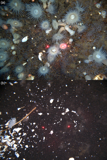
In addition, an iceberg had ploughed across the peak in one area, decimating the benthic community (Fig. 4). Along the edge of the scour, Homaxinella balfourensis had disappeared, leaving Artemidactis victrix as the dominant species along with Clavularia frankliniana. Within the iceberg scour zone, nearly all sessile fauna were removed, and only a few individuals of motile species were found, along with crushed shells of the clam Laternula elliptica. Though different overall areas were sampled in 2012 (approximately 4 m2) and 2014 (approximately 1 m2) species richness remained similar in the Homaxinella zone, though it was reduced by half in the Alcyonium zone; this could have been an artefact of the reduced area. Interestingly, in the Artemidactis zone along the edge of the iceberg scour, species richness (8) was greater than in the Homaxinella zone (5), supporting the idea that many species were hidden by the H. balfourensis cover. Species richness in the iceberg scour was very low (3) and reflected three single individuals.
Example images from the iceberg scour and edge on Mystery Peak in 2014, (a). Artemidactis dominated edge, and (b). Iceberg scour. Distance between red laser dots is 10 cm in each image.

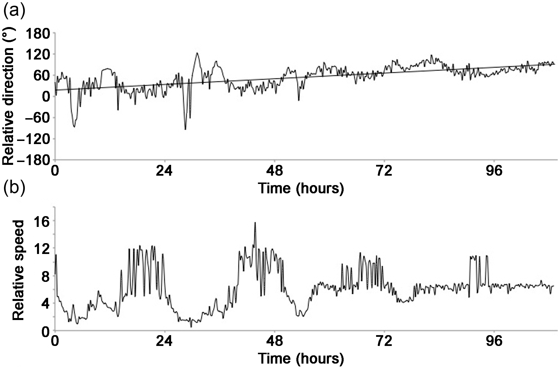
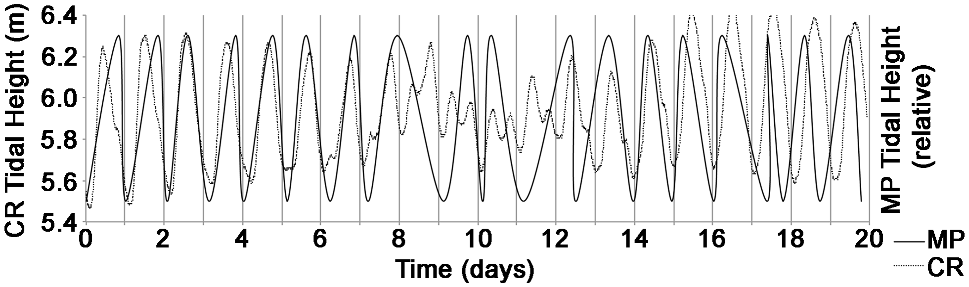
The SeeStar time-lapse camera at Mystery Peak was knocked over by strong currents just nine days into the two-month deployment. While it was upright, the length and direction of a branch of Homaxinella balfourensis in the images tracked relative current velocity. The current trended in a single direction, ±50°, and gradually shifted direction over days (Fig. 5). Current speed varied on a diurnal cycle. Once the tripod was on its side and the recovery line froze into the sea ice above, the angle of the tripod to the sea floor changed with tidal motion and recorded a rough tidal pattern over 20 days (Fig. 6).
Relative current velocities at Mystery Peak. (a). Relative current direction over 4.5 days, measured as angle from horizontal of a branch of Homaxinella balfourensis. Straight line indicates the overall trend. (b). Relative current speed over 4.5 days, measured as visible length (cm) of a branch of H. balfourensis.

Relative tidal pattern at Mystery Peak, compared to tidal pattern at Cape Roberts recorded by Toitu Te Whenua/Land Information New Zealand (https://sealevel-data.linz.govt.nz/RBCT/2021/). MP = Mystery Peak, CR = Cape Roberts.

During the time that the camera was upright, we observed strong site fidelity in individual fishes, along with apparent site competition. One small Trematomus sp. fish favoured perching on a Cnemidocarpa verrucosa tunicate, but was periodically displaced by a larger Trematomus sp. individual, and would move to a nearby, but evidently less desirable, C. verrucosa. Up to four Trematomus sp. were seen at a time, and all apparently preferred resting on C. verrucosa rather than the far more abundant Homaxinella balfourensis. During the deployment, four scavenging/predatory species moved through the field of view (pycnogonid, Odontaster validus, Sterechinus neumayeri and Tritoniella belli).
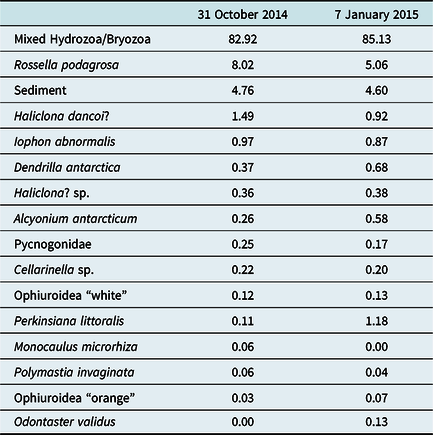
The community at Tongue Peak was dominated by a mat of mixed hydroids and bryozoans (Table 3). Sponges, primarily the root sponge Rossella podagrosa, covered 11.27 and 7.94% of the substrate at the beginning and end of the deployment, respectively. Approximately 5% of the visible substrate was bare volcanic sand/gravel. Pycnogonid sea spiders seemed to prefer the bare patches of substrate.
Percent cover of species in still images taken by SeeStar at Tongue Peak in 2014–15. Image area was 1.3 m2.

There was very little change over the two-month deployment at Tongue Peak; two exceptions were the disappearance of the hydroid Monocaulus microrhiza and the appearance of the seastar Odontaster validus. The time-lapse imagery showed that M. microrhiza was still present within a few hours of the end of the deployment, though in a different location and presumably a different individual as these are a sessile species. Though M. microrhiza can retract, this was not observed during a sample 24-h period. Time lapse also showed that O. validus began moving into the frame approximately 12 h after the start of the deployment. Other small differences in coverage of other taxa were due to changes in lighting as the batteries drew down towards the end of the deployment, different presentation aspects when currents shifted, and retraction of individuals (e.g. the difference in Perkinsiana littoralis was due to a single individual expanding).
Over a 24-h sample time period, additional species moved into the frame, including the nemertean Parborlasia corrugata, an unidentified scale worm, an unidentified sea cucumber, and the nudibranch Tritoniella belli. Pycnogonids were the only individuals that moved more than once in 24 h.
Discussion
Isolated topographic highs appear to be a common but unrecognised feature of the sea floor in McMurdo Sound, Antarctica. While these are smaller than traditionally defined seamounts, which rise hundreds of metres above the abyssal plain at thousands of metres depth, the McMurdo “mini-seamounts” exhibit some similar characteristics (Samadi, Schlacher, & Richer de Forges, Reference Samadi, Schlacher, Richer de Forges, Pitcher, Morato, Hart, Clark, Haggan and Santos2007). They are likely of volcanic origin, given the volcanic nature of the adjacent Ross Island and the terrestrial expression of cinder cones nearby (Kyle, Reference Kyle1976, http://www.geokem.com/OIB-volcanic-antarctic.html). Current speeds were high over the top of Mystery Peak, enough to topple the small-profile and bottom-weighted SeeStar, and potentially supply large amounts of food for suspension feeders (sensu Raguá-Gil, Gutt, Clarke, & Arntz, Reference Raguá-Gil, Gutt, Clarke and Arntz2004; Samadi et al., Reference Samadi, Schlacher, Richer de Forges, Pitcher, Morato, Hart, Clark, Haggan and Santos2007). Deep sea floor interrupted by isolated patches at shallower depths mimics an island archipelago distribution of habitat, introducing challenges in dispersal for species that cannot survive in the deeper areas (sensu Mullineaux & Mills, Reference Mullineaux and Mills1997; Parker & Tunnicliffe, Reference Parker and Tunnicliffe1994).
In many other locations worldwide, seamounts are known to host unusual benthic communities (Bowden, Schiaparelli, Clark & Rickard, Reference Bowden, Schiaparelli, Clark and Rickard2011; Rogers, Reference Rogers1994; Wilson & Kaufmann, Reference Wilson and Kaufmann1987). Nevertheless, the benthic communities atop Mystery Peak and Tongue Peak were not different from those previously observed in surrounding areas (Cattaneo-Vietti et al., Reference Cattaneo-Vietti, Chiantore, Gambi, Albertelli, Cormaci and Di Geronimo2000; Dayton, Reference Dayton1989; Dearborn, Reference Dearborn1965, Reference Dearborn1967; Szuta, Reference Szuta2017). Filter-feeding taxa dominated, sponges and soft corals at Mystery Peak, and hydroids and bryozoans at Tongue Peak. High current speeds may contribute to the success of this feeding strategy (Gili & Coma, Reference Gili and Coma1998; Gili, Coma, Orejas, Lopez-Gonzalez, & Zabala, Reference Gili, Coma, Orejas, Lopez-Gonzalez and Zabala2001). The similarities to communities found in surrounding areas indicate that larval supply is not a limiting factor; the long-lived larvae typical of many Antarctic species may promote wide dispersal (Thatje, Reference Thatje2012).
The “cap” of Homaxinella balfourensis on the very top of Mystery Peak was unusual in that this community is very temporally variable (Dayton, Reference Dayton1989). Dayton (Reference Dayton1989) previously observed massive recruitment and persistence of H. balfourensis during a time period when annual disturbance by anchor ice was minimal. Once established, H. balfourensis re-recruits locally in high enough numbers to overcome predation pressure from abundant asteroid sea stars. While larval production appears consistent, changes in oceanographic conditions may change local larval supply, and habitat availability and predation pressure influence recruitment success. The topographic high of Mystery Peak, though below the depth of anchor ice formation and thus safe from this disturbance, is vulnerable to repeated scouring by icebergs, as evidenced by the iceberg scour track observed in 2014. Icebergs often nearly denude the sea floor in large swaths (Gutt, Reference Gutt2001; Kim & Collins, Reference Kim and Collins2021), as was seen in this study. Resulting open habitat and lack of predators and competitors provided the opportunity for massive recruitment of H. balfourensis and establishment of the observed community.
Along the edge of the iceberg scour observed in 2014 was an ecotone community dominated by Artemidactis victrix and Clavularia frankliniana. It is possible that the anemone, which can slowly crawl on its pedal disc, was opportunistically moving into the newly opened area. That this species is somewhat mobile is evidenced by the several specimens that had climbed onto the frame of the toppled SeeStar and came up with it on recovery (Fig. 2b). It is possible that C. frankliniana was present in higher abundances than recorded in the Homaxinella zone but was underestimated because it was poorly visible through the thick Homaxinella balfourensis cover. The stoloniferous buried attachment of these soft corals may have made them more resistant to removal by iceberg scouring than the small superficial attachment to gravel and rocks of H. balfourensis, allowing C. frankliniana to persist along the edge of the iceberg scour zone.
The high numbers of Clavularia frankliniana along the edge of the iceberg scour might also be due to a generalised increase in the abundance of this taxa with time. Over the two years between observations at Mystery Peak, abundances of C. frankliniana increased, and of hydroids/bryozoans decreased. Clavularia frankliniana reproduces by brooding and by fission (Slattery & McClintock, Reference Slattery and McClintock1997), and either (or both) of these are likely to result in growth of established populations.
At Tongue Peak, hydroids and bryozoans dominated the community. Very little community change was seen over the two-month deployment. A few individuals of the seastar Odontaster validus moved into the frame after 12 h but did not continue to move far and may have been attracted by the minor disturbance of the SeeStar landing on the sea floor. This scavenger is rapidly attracted to food or damaged individuals and moves to new food resources within hours (Kim, Thurber, Hammerstrom, & Conlan, Reference Kim, Thurber, Hammerstrom and Conlan2007).
Pycngonids were the only taxa that were frequently active at Tongue Peak, sometimes moving more than once per day. This taxa is classified as predatory and scavenging (Moran, Woods, Shishido, Lane, & Tobalske, Reference Moran, Woods, Shishido, Lane and Tobalske2018). The other mobile taxa found, the seastar Odontaster validus, nemertean worm Parborlasia corrugata, nudibranch Tritoniella belli, and brittle stars, employ similar feeding modes (Fratt & Dearborn, Reference Fratt and Dearborn1984; Gibson, Reference Gibson1983; Pearse, Reference Pearse and Lawrence2013; Wägele, Reference Wägele1989) but moved infrequently or not at all. This contrast to the frequent movement of pycnogonids suggests that the pycnogonids tend towards the active predator end of the spectrum, while the other taxa are more scavengers.
Despite their relative spatial proximity, there were community differences between the two sites (sensu Dorschel, Gutt, Piepenburg, Schröder, & Arndt, Reference Dorschel, Gutt, Piepenburg, Schröder and Arndt2014). The area of Mystery Peak that was not disturbed by icebergs was mostly bare sediment with hydroids/bryozoans in 2012, but the hydroids/bryozoans had been replaced by Clavularia frankliniana by 2014. Tongue Peak was dominated by hydroids/bryozoans and Rossella podagrosa. The difference with depth follows the pattern found by Szuta (Reference Szuta2017), working at nearby Knob Point. She described a community break at 75 m, which correlated with the depth where benthic diatom cover disappeared. The shallow community (30–75 m) she observed was dominated by bare substrate and hydroids/bryozoans, as was the Mystery Peak (40 m) community in this study. The deep community (75–315 m) recorded by Szuta (Reference Szuta2017) was dominated by hydroids/bryozoans and spicule mat substrate. The spicule mat is most likely due to, and hides, R. podagrosa (Dayton et al., Reference Dayton, Jarrell, Kim, Parnell, Thrush, Hammerstrom and Leichter2019; pers obs). Tongue Peak, at 70 m, was just shoal of the 75 m break but matched the deep community description of Szuta (Reference Szuta2017). Our observations fit the larger pattern of a food-driven depth zonation in McMurdo Sound. Community zonation with depth has also been found on topographic highs at similar depths in the Weddell Sea (Dorschel et al., Reference Dorschel, Gutt, Piepenburg, Schröder and Arndt2014; Raguá-Gil et al., Reference Raguá-Gil, Gutt, Clarke and Arntz2004).
Water depths in McMurdo Sound have not been charted at a fine scale. Unmapped bathymetric highs in McMurdo Sound act as pinning points for icebergs, which cause intense disturbances to sea floor communities (Gutt, Reference Gutt2001). The sea floor peaks thus form an integral part of the pattern of successional recovery that defines the Antarctic benthos (Gutt & Starmans, Reference Gutt and Starmans2002). Bathymetric highs cause shifts in local current patterns and thus influence the movement of sea ice and melt patterns under ice shelves (Nghiem, Rigor, Clemente-Colón, Neumann, & Li, Reference Nghiem, Rigor, Clemente-Colón, Neumann and Li2016, Tinto et al., Reference Tinto, Padman, Siddoway, Springer, Fricker, Das and Siegfried2019). While the bathymetry remains undefined, effects on ice dynamics and its cascading influence at wider scales cannot be fully understood.
The overall performance of the SeeStar time-lapse systems under Antarctic conditions was excellent. The electronics and power systems are suitable for long-term use in −2°C temperatures. We collected over 4500 images in two months with each system, and the power included supplying the illumination needed to capture images in low light conditions. These systems could be deployed for a year and incorporate a winter season, providing the opportunity to understand food input on an annual cycle, which remains a key question in Antarctic ecology (Mincks, Smith, Jeffreys, & Sumida, Reference Mincks, Smith, Jeffreys and Sumida2008). The tripod and mooring system can easily be improved to prevent toppling over in very strong currents by adding a fairing to the camera and electronics package, and using a smaller diameter recovery line. Critical to the success of SeeStar was the ease of use through frozen sea ice. Robust and elegant engineering that minimised cross-sectional area allowed deployment, and more importantly, recovery, through a 25-cm hole, which is easily drilled through sea ice (Cazenave et al., Reference Cazenave, Zook, Carroll, Flagg and Kim2011). SeeStar is a superb addition to the suite of tools available to Antarctic researchers.
Acknowledgements
Craig Stevens, Lee Fuiman and Erin Frolli kindly shared the locations of topographic/magnetic highs they discovered in McMurdo Sound and we appreciate their openness. We are very grateful to Chad Kecy, Laughlin Barker and MBARI for their generous support. Marty Hynes provided additional engineering assistance and assurance. We appreciate diving and imagery expertise supplied by Rob Robbins, Steve Rupp, Clint Collins and Andrew Thurber. We thank the MLML Benthic Lab and the USAP support staff for ably dealing with innumerable critical details. We thank the editor and anonymous reviewers for improving the paper.
Financial Support
This material is based on work supported by the National Science Foundation under grants ANT-0944747 and OPP-0619622. Any opinions, findings and conclusions or recommendations expressed in this material are those of the authors and do not necessarily reflect the views of the National Science Foundation.
Conflict of interest
The authors declare none.