

INTRODUCTION
Schistosomiasis continues to exert pressure against social and economic development, particularly in sub-Saharan Africa where more than 80% of the total number of infected individuals and the global burden of this often neglected tropical disease are concentrated (WHO, 2002; Steinmann et al. Reference Steinmann, Keiser, Bos, Tanner and Utzinger2006). Despite considerable progress made in morbidity control of schistosomiasis in several African countries – facilitated through large-scale administration of praziquantel to school-aged children and other high-risk groups (Kabatereine et al. Reference Kabatereine, Brooker, Koukounari, Kazibwe, Tukahebwa, Fleming, Zhang, Webster, Stothard and Fenwick2007; Koukounari et al. Reference Koukounari, Gabrielli, Toure, Bosque-Oliva, Zhang, Sellin, Donnelly, Fenwick and Webster2007) – the disease has expanded elsewhere and the transmission has intensified in areas where water resources have been developed, such as large dams and irrigation systems (Fenwick, Reference Fenwick2006; Steinmann et al. Reference Steinmann, Keiser, Bos, Tanner and Utzinger2006).
Important to the transmission biology of schistosomiasis in Africa are several species of aquatic snails that act as intermediate hosts for the development of the parasite to an infective free-swimming larval stage, i.e. cercariae. Humans acquire an infection through cercarial skin penetration during water contact. There are several principal intermediate host snails belonging to two genera; Bulinus transmitting Schistosoma haematobium and Biomphalaria transmitting S. mansoni (Brown, Reference Brown1994). It follows that the transmission of schistosomiasis is spatially and temporally restricted to water bodies inhabited by intermediate host snails when humans get in contact with the water infested with cercariae during occupational or recreational activities. Schistosomiasis has therefore been defined as an environmental disease (Malone, Reference Malone2005; Liang et al. Reference Liang, Seto, Remais, Zhong, Yang, Hubbard, Davis, Gu, Qiu and Spear2007). Hence, a deeper knowledge of ecological factors, permissive to the development of the parasite-intermediate host snail system, is important to target control interventions.
In 1970, the potential of aerial pictures and other remote sensing (RS) techniques to enhance our understanding of the epidemiology and control of tropical diseases was first highlighted (Cline, Reference Cline1970). Fourteen years later, the first RS applications to predict the occurrence of human schistosomiasis in the Caribbean and the Philippines were published (Cross and Bailey, Reference Cross and Bailey1984; Cross et al. Reference Cross, Sheffield, Perrine and Pazzaglia1984). In 1994, the first successful application of remotely-sensed temperature data, coupled with geographical information system (GIS) for prediction of human schistosomiasis was presented for the Nile delta, Egypt (Malone et al. Reference Malone, Huh, Fehler, Wilson, Wilensky, Holmes and Elmagdoub1994).
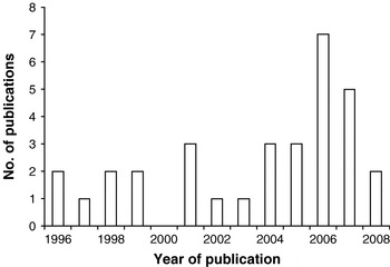
The past 15 years have seen a considerable growth of RS and GIS applications in human and veterinary epidemiology (Robinson, Reference Robinson2000; Brooker, Clements and Bundy, Reference Brooker, Clements and Bundy2006; Hay et al. Reference Hay, Tatem, Graham, Goetz and Rogers2006; Rinaldi et al. Reference Rinaldi, Musella, Biggeri and Cingoli2006), including human schistosomiasis (Brooker, Reference Brooker2002; Yang et al. Reference Yang, Vounatsou, Zhou, Utzinger and Tanner2005). To illustrate this issue, we accessed PubMed (http://www.ncbi.nlm.nih.gov/sites/entrez) in early 2009, and entered the following combination of terms and Boolean operators: “remote sensing” OR “geographical information system” OR “mapping” OR “prediction” AND “schistosomiasis” AND “Africa”. We temporally restricted our search back to 1996, which revealed 41 hits, of which 32 were of relevance. Fig. 1 shows the yearly number of publications between 1996 and 2008. Several reviews have already been published that emphasise the potential of RS and GIS technologies, particularly in conjunction with spatial analysis, for the ecology, epidemiology and control of schistosomiasis (Brooker and Michael, Reference Brooker and Michael2000; Brooker, Reference Brooker2002, Reference Brooker2007; Malone, Reference Malone2005; Yang et al. Reference Yang, Vounatsou, Zhou, Utzinger and Tanner2005). Here, we summarize progress made to date with the application of RS and GIS with a focus on Africa, for risk mapping and prediction of (1) patterns of human schistosome infection, and (2) intermediate host snail distributions. Our review builds on the recent discussion by Brooker (Reference Brooker2007) on the spatial epidemiology of schistosomiasis in Africa and highlights remaining challenges. Finally, it discusses opportunities for integrating risk mapping of schistosomiasis with a number of other tropical diseases and therefore complements Brooker and colleagues' (Reference Brooker, Kabatereine, Gyapong, Stothard and Utzinger2009) review on integrated rapid survey methods for schistosomiasis and other neglected tropical diseases, published in the same issue of Parasitology.
Number of publications pertaining to RS and GIS with application to schistosomiasis in Africa, published between 1996 and 2008.

WORKING DEFINITIONS
Box 1 provides a summary of common definitions for key terms utilized in the current review. These working definitions might help to better understand the potential applications of RS and GIS for the mapping of human schistosome infections and the distribution of intermediate host snails at various spatial and temporal scales.
Box 1. Working definitions used in the current review
Remote sensing (RS), in the broadest sense, refers to the acquisition of information of an object or phenomenon, employing either a real-time sensing device that is not in physical or intimate contact with the object itself, e.g. by means of an aircraft or a satellite. In the current review, we refer to the use of imaging sensor technologies aboard satellites primarily for the acquisition of environmental data.
Geographical information system (GIS) has been defined as “an organized collection of computer hardware, software, geographical data, and personnel designed to efficiently capture, store, update, manipulate, analyze, and display all forms of geographically referenced information” (ESRI, 1990). For disease epidemiology at an exploratory level, GIS is well suited for the study of associations between location, disease, vector/intermediate host and environment, due to its display capabilities.
Spatial analysis in relation to GIS, in broad terms, can be described as the ability to manipulate spatial data into different forms and extract additional meaning as a result. In a spatial epidemiology context, one can distinguish between three types of spatial analysis tasks, namely (1) visualization/mapping, (2) exploratory data analysis, and (3) modelling (Bailey and Gatrell, Reference Bailey and Gatrell1995).
Visualization/mapping can be used in a variety of ways to explore the results of traditional statistical analyses that have been undertaken in more powerful statistical analysis software. With regard to GIS applications, the primary visualization tool is the map, which can help display for policy and strategic planning and aid in the validation of model predictions.
Exploratory data analysis aids in the detection of patterns, anomalies and the formulation of new hypotheses about the processes that gave rise to the data. Although exploratory data analysis is closely related to visualization, it often includes simplified statistical tests to explore potential predictors of the disease, smoothing/interpolation techniques as well as simplified modelling to highlight spatial patterns and empirical variogram estimation (for continuous outcome disease data) to explore spatial correlation.
Modelling involves techniques for estimating transmission parameters over the earth's surface. Model complexity varies from climatic suitability (e.g. niche) models to spatial statistical models. The later aim (1) to assess statistical significance between predictors and spatially correlated disease outcome data, (2) to establish a mathematical relation between the disease and its predictor, and (3) to obtain model-based predictions (with uncertainty estimates) of the disease outcome at non-sampled locations (kriging) in case the disease data are available at fixed locations (geostatistical data) instead of being aggregated over adjacent area units (area data). Geostatistical models have large number of parameters (at least as many as the number of locations). For non-continuous data such as prevalence or count data maximum likelihood-based approaches (frequentist inference) are possible only via asymptotic approximations (Gemperli and Vounatsou, Reference Gemperli and Vounatsou2004). Bayesian geostatistical models overcome asymptotic inference via Markov chain Monte Carlo (MCMC) simulation methods. Spatial statistical capabilities of GIS software are limited to continuous data and are not appropriate for prevalence or count disease data.
WHY RS AND GIS APPLICATIONS LEND THEMSELVES FOR SCHISTOSOMIASIS RISK MAPPING
Schistosomiasis is amenable to risk mapping since the development and survival of the parasite within the intermediate host snail and the snails themselves are sensitive to climatic factors, principally temperature (Appleton, Reference Appleton1978; Brooker and Michael, Reference Brooker and Michael2000; Zhou et al. Reference Zhou, Yang, Yang, Wang, Hong, Sun, Malone, Kristensen, Bergquist and Utzinger2008). Roughly, the optimal temperature range for Bulinus spp. and Biomphalaria spp. development is between 20°C and 30°C, with thermal death occurring at temperatures either below 16°C or above 40°C. Since temperature and altitude are strongly correlated, the latter is often used as a proxy of transmission, although the precise level varies according to setting (Brooker and Michael, Reference Brooker and Michael2000). Several studies have also found an association between snail distribution, abundance and rainfall; without water snails cannot survive, whereas too much water can wash away snail populations. All of these climatic determinants of transmission are readily available from RS sources (for a review see Hay et al. (Reference Hay, Tatem, Graham, Goetz and Rogers2006)), and hence can be used to develop risk models.
Man-made ecological transformations, such as deforestation (Walsh, Molyneux and Birley, Reference Walsh, Molyneux and Birley1993), changes in agricultural practices (Matthys et al. Reference Matthys, Tschannen, Tian-Bi, Comoé, Diabaté, Traoré, Vounatsou, Raso, Gosoniu, Tanner, Cissé, N'Goran and Utzinger2007), water resources development and management (Fenwick, Reference Fenwick2006; Steinmann et al. Reference Steinmann, Keiser, Bos, Tanner and Utzinger2006; Yang et al. Reference Yang, Vounatsou, Tanner, Zhou and Utzinger2006) and climate change (Martens, Jetten and Focks, Reference Martens, Jetten and Focks1997; Zhou et al. Reference Zhou, Yang, Yang, Wang, Hong, Sun, Malone, Kristensen, Bergquist and Utzinger2008), also determine transmission and can be captured by RS technologies as shown in some of the references cited above. However, there are several other important factors that determine localized transmission that cannot readily be captured by RS data. These include demographic features and socio-economic status (Raso et al. Reference Raso, Vounatsou, Singer, N'Goran, Tanner and Utzinger2006), access to clean water and adequate sanitation and educational attainment (Arinola, Arinola and Ojewale, Reference Arinola, Arinola and Ojewale1996; Taylor et al. Reference Taylor, Coovadia, Kvalsvig, Jinabhai and Reddy1999). Such a complexity of factors contributes to the well-known focality of schistosomiasis, and suggests that patterns are more easily predicted at regional and national scales and that either more complex models are required to predict patterns at local scales or that field surveys are still required to finely target treatment and other interventions (Brooker, Reference Brooker2007; Brooker et al. Reference Brooker, Kabatereine, Gyapong, Stothard and Utzinger2009; Vounatsou et al. Reference Vounatsou, Raso, Tanner, N'Goran and Utzinger2009).
PREDICTING PATTERNS OF HUMAN INFECTION
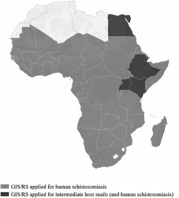
Using climatic determinants of parasite transmission, several studies have developed Africa-wide risk maps for malaria transmission (Craig, Snow and le Sueur, Reference Craig, Snow and le Sueur1999; Hay and Snow, Reference Hay and Snow2006; Guerra et al. Reference Guerra, Hay, Lucioparedes, Gikandi, Tatem, Noor and Snow2007) and lymphatic filariasis (Lindsay and Thomas, Reference Lindsay and Thomas2000). In theory it should also be possible to develop a climate-based risk model for schistosomiasis across the continent, although to date, no such map exists. An on-going project has employed GIS to develop a comprehensive database of schistosome (and other helminth) infections in Africa and provides district-level spatial descriptions, which highlights the paucity of empirical data in much of the continent (Brooker et al. Reference Brooker, Rowlands, Haller, Savioli and Bundy2000). A recent initiative, CONTRAST (see: http://www.eu-contrast.eu), has brought together existing electronic information (published and unpublished data) into a single database (Fig. 2). By displaying data on Google Earth and using an open-source platform accessible from the web, data management and sharing of information could become a useful tool for schistosomiasis control managers and for long-term surveillance of the disease (Stensgaard et al. Reference Stensgaard, Saarnak, Utzinger, Vounatsou, Simoonga, Mushinge, Rahbek, Møhlenberg and Kristensen2009).
Map of Africa depicting the countries where GIS and RS applications have been used for the mapping and prediction of human schistosomiasis and intermediate host snails (and human infection).

A particular challenge in developing a continent-wide, climate-based schistosomiasis risk map lies in the variation in biotic requirements of different intermediate host snail species that occur throughout Africa. This feature was previously emphasised in connection with separate schistosomiasis climatic-suitability risk models developed for Cameroon and Tanzania and an attempt to apply each model to the other setting. It was found that, while each model provided a reasonable prediction in the setting where they were developed, they were unable to predict risk in other settings reliably. However, each model could be extrapolated within the same ecological zone, presumed to reflect the distribution of different intermediate host snail species (Brooker, Hay and Bundy, Reference Brooker, Hay and Bundy2002a). Therefore, in order to develop a continental risk map for schistosomiasis, there would be the need to construct a composite risk map, which takes into account different ecological zones and differential snail distributions and compatibilities thereof. The above-mentioned EU-funded CONTRAST project has taken up the challenge of developing schistosomiasis climatic suitability risk maps as well as empirical maps based on spatial statistical models and detailed knowledge of the local snail fauna.
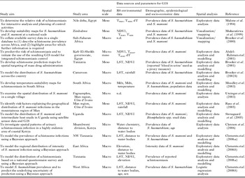
Such a continental risk map can be characterized as a macro-level description of schistosomiasis risk. Thus far, models of schistosomiasis have mainly been developed at regional and national scales; the latter of which is considered meso-level. Further models have been developed at local scales (unit of a single village or district), so-called micro-level models. Table 1 provides an overview of studies which have investigated the risk of human schistosome infection, emphasizing the scale, what kind of RS environmental data were utilized and the application of GIS and spatial analysis.
Characteristics of studies using GIS, RS and spatial analysis for the mapping and prediction of human schistosomiasis and transmission modelling

dT, temperature difference; LST, land surface temperature; Mdn, mean daily minimum temperature; Mdx, mean daily maximum temperature; n.d., not determined; NDVI, normalized difference vegetation index; Tmax, maximum temperature; Tmin, minimum temperature.
Employing a variety of statistical approaches, national-level or sub-national models of schistosomiasis risk have been developed in Cameroon (Brooker et al. Reference Brooker, Hay, Tchuem Tchuente and Ratard2002b), Egypt (Malone et al. Reference Malone, Huh, Fehler, Wilson, Wilensky, Holmes and Elmagdoub1994; Abdel-Rahman et al. Reference Abdel-Rahman, El-Bahy, Malone, Thompson and El-Bahy2001), Ethiopia (Malone et al. Reference Malone, Yilma, McCarroll, Erko, Mukaratirwa and Zhou2001), South Africa (Moodley et al. Reference Moodley, Kleinschmidt, Sharp, Craig and Appleton2003), Tanzania (Brooker et al. Reference Brooker, Hay, Issae, Hall, Kihamia, Lwambo, Wint, Rogers and Bundy2001, Reference Brooker, Hay and Bundy2002a; Clements et al. Reference Clements, Lwambo, Blair, Nyandindi, Kaatano, Kinung'hi, Webster, Fenwick and Brooker2006a), Uganda (Kabatereine et al. Reference Kabatereine, Brooker, Tukahebwa, Kazibwe and Onapa2004; Stensgaard et al. Reference Stensgaard, Jorgensen, Kabatereine, Malone and Kristensen2005), Zimbabwe (Mukaratirwa et al. Reference Mukaratirwa, Malone, McCarroll and Kristensen1999) and Zambia (Simoonga et al. Reference Simoonga, Kazembe, Kristensen, Olsen, Appleton, Mubita and Mubila2008). The earliest of these studies were based on simple threshold analysis or traditional regression modelling to predict infection risk; more recently, studies have adopted a Bayesian platform of analysis. Using a Bayesian geostatistical method of inference, a regional-scale map of the intensity of S. mansoni infection has been developed for East Africa (Clements, Moyeed and Brooker, Reference Clements, Moyeed and Brooker2006b), and for high-risk areas of S. haematobium in West Africa (Clements et al. Reference Clements, Garba, Sacko, Touré, Dembelé, Landouré, Bosque-Oliva, Gabrielli and Fenwick2008b). As indicated above, other factors may also determine infection patterns, including demographic, educational and socio-economic status and ecological transformations, which could be included into available meso-level models. However, such complex models are not currently available.
At the micro-scale, a number of studies have been carried out in the region of Man, western Côte d'Ivoire and in different parts of Kenya. In Côte d'Ivoire, for example, one investigation focused on the spatial distribution of S. mansoni among schoolchildren from a single village and concluded that there was no clear pattern of infection risk, probably explained by a limited number of transmission sites that are accessed by most of the schoolchildren (Utzinger et al. Reference Utzinger, Müller, Vounatsou, Singer, N'Goran and Tanner2003). In-depth studies focusing on over 50 rural schools covering an area of 40×60 km allowed developing an integrated risk profiling approach for prediction of high-risk areas of S. mansoni. A variety of data sources (i.e. demographic data obtained from readily available school registries, RS environmental data and digitized ground maps, and socio-economic data collected through a cross-sectional questionnaire survey administered by teachers), was utilized for setting up a comprehensive GIS, including a digital elevation model. Bayesian geostatistical models were fitted to probe for significant associations between an infection with S. mansoni and demographic, environmental and socio-economic factors. With regard to environmental data, at the unit of the school, significant correlations were found between the infection prevalence of S. mansoni and stream order of the nearest river, water catchment area and altitude (Raso et al. Reference Raso, Matthys, N'Goran, Tanner, Vounatsou and Utzinger2005, Reference Raso, Vounatsou, Singer, N'Goran, Tanner and Utzinger2006; Beck-Wörner et al. Reference Beck-Wörner, Raso, Vounatsou, N'Goran, Rigo, Parlow and Utzinger2007).
In Kenya, a number of studies have been carried out to assess the risk of schistosomiasis at a micro-scale (Handzel et al. Reference Handzel, Karanja, Addiss, Hightower, Rosen, Colley, Andove, Slutsker and Secor2003; Booth et al. Reference Booth, Vennervald, Kenty, Butterworth, Kariuki, Kadzo, Ireri, Amaganga, Kimani, Mwatha, Otedo, Ouma, Muchiri and Dunne2004; Clennon et al. Reference Clennon, King, Muchiri, Kariuki, Ouma, Mungai and Kitron2004). Along the southern coast of Kenya, for example, high S. haematobium infection intensities were clustered around water bodies containing high numbers of infected intermediate host snails (Clennon et al. Reference Clennon, King, Muchiri, Kariuki, Ouma, Mungai and Kitron2004). The prevalence of intestinal schistosomiasis among children attending schools near Lake Victoria was positively associated with proximity to the lake shore and specific water-related activities such as swimming, fishing and collecting water (Handzel et al. Reference Handzel, Karanja, Addiss, Hightower, Rosen, Colley, Andove, Slutsker and Secor2003; Stothard et al. Reference Stothard, Kabatereine, Tukahebwa, Kazibwe, Mathieson, Webster and Fenwick2005).
A clear inference from the studies summarized in Table 1 is the importance of considering the snail species involved in schistosome transmission. The next section reviews studies which have attempted to predict the distribution of intermediate host snail species across Africa.
PREDICTING INTERMEDIATE HOST SNAIL DISTRIBUTIONS
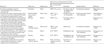
Reviewing the literature has revealed that only a few studies have utilized GIS and RS for mapping and modelling schistosome intermediate host snail distribution in different parts of Africa (Table 2). Most of these studies have used GIS in conjunction with RS environmental data proxies, to produce climatic suitability maps for the intermediate host snails. As with the human infection predictions, most studies using GIS and RS to map the snail distributions, have been conducted at the national (meso-) scale, a few at the micro-scale (Clennon et al. Reference Clennon, Mungai, Muchiri, King and Kitron2006) – but none so far has attempted a continent-wide mapping.
Characteristics of studies using GIS, RS and spatial analysis for the mapping and prediction of human schistosomiasis and transmission modelling, using data on intermediate host snails.

dT, temperature difference; LST, land surface temperature; NDVI, normalized difference vegetation index; Tmax, maximum temperature; Tmin, minimum temperature.
The first study to include snail data in relation to schistosomiasis risk was carried out by Kristensen and colleagues (Kristensen, Malone and McCarroll, Reference Kristensen, Malone and McCarroll2001) in Ethiopia. Subsequent studies that used climatic and environmental data to predict human schistosome infection could be improved by the addition of snail-specific distribution data. For example, the use of disease and temperature data facilitated the delineation of areas permissible for S. mansoni and S. haematobium transmission in South Africa. It has been speculated that the models could have been validated and further refined by using snail distribution maps as an integral part in the models. Since the distribution of freshwater snails in South Africa is well documented, it would seem logical and straightforward to combine this information with previous results published in the peer-reviewed literature (Moodley et al. Reference Moodley, Kleinschmidt, Sharp, Craig and Appleton2003).
We conjecture that investigations that will shed light on the ecological requirements of the intermediate host snails are essential, because they will deepen our understanding of basic factors for schistosomiasis transmission. Using environmental or climatic data such as land surface temperature (LST), rainfall or normalized difference vegetation index (NDVI) to predict the risk of schistosomiasis, in effect, one is predicting the environmental requirements for a particular snail species (infected with a particular parasite species) – and not the human parasitic infection per se. A further refinement of the prediction is to include human infection predictors such as socio-economic status and behaviour, as has been stressed in the previous section. Furthermore, the mapping of infected snails – not just snail or human infection – could help clarify the complex interaction between snail, parasites and the environmental factors that are usually employed to predict their distributions.
There are a number of challenges that must be overcome in order to further improve the GIS-based mapping of intermediate host snails at a continental scale. An important shortcoming is the scarceness of geo-referenced quality data even on the presence/absence of snails, let alone parasite-snail compatibilities. Another complication is the fact that in certain areas the complete understanding of species identity and its capability as intermediate host snails has yet to be fully understood (Stothard et al. Reference Stothard, Mgeni, Khamis, Kristensen, Hubbard, Seto, Ramsan and Rollinson2002). It would be recommended to build more on the experiences and methodologies of the bio-geographical (macro-ecological) sciences in mapping species distribution and diversity. An overview of these methodologies, together with their strengths and weaknesses can be found in a recent review by Elith et al. (Reference Elith, Graham, Anderson, Dudik, Ferrier, Guisan, Hijmans, Huettmann, Leathwick, Lehmann, Li, Lohmann, Loiselle, Manion, Moritz, Nakamura, Nakazawa, Overton, Peterson, Phillips, Richardson, Scachetti-Pereira, Schapire, Soberón, Williams, Wisz and Zimmermann2006). However, until now only few researchers have taken up the task of relating intermediate host snails and snail diversity to environmental factors, disease prevalences, demographic and socioeconomic profiles of the local population through the opportunities GIS and RS offer.
CONCLUSIONS
The use of GIS and RS technologies – increasingly employed in concert with spatial analysis – to further our understanding of the ecology and epidemiology of schistosomiasis in sub-Saharan Africa, and hence spatial targeting of control interventions has been harnessed for sometime now. We believe that these tools can make an important contribution towards optimized schistosomiasis control efforts at different spatial scales. Indeed, the use of RS and GIS have been instrumental for identification of high-risk areas in order to prioritize subsequent control interventions of national schistosomiasis control programmes of Uganda, Tanzania and in West Africa (Brooker, Reference Brooker2007; Clements et al. Reference Clements, Brooker, Nyandindi, Fenwick and Blair2008 a,b). In Uganda, for example, early geographical analyses concluded that no S. mansoni transmission occurred in areas characterized by annual precipitation below 850 mm or at altitudes above 1400 m (Kabatereine et al. Reference Kabatereine, Brooker, Tukahebwa, Kazibwe and Onapa2004). On the other hand, high S. mansoni prevalences (>50%) were consistently observed in areas within 5 km of Lake Victoria and Lake Albert, and hence these areas were selected for mass treatment with praziquantel without further surveys. Rapid parasitological mapping was conducted in the remaining areas, using the lot quality assurance sampling (Brooker et al. 2009 – in this issue of the journal). A small team collected stool samples from only about 15 children per locality; if more than 7 children were infected with S. mansoni, mass treatment was initiated. It will be interesting to monitor the spatial distribution of schistosome infections as control efforts are further intensified, so that spatial targeting of control interventions can be readily adapted and areas at highest risk identified and prioritized for subsequent control interventions. In Burkina Faso, Mali and Niger, Bayesian spatial modelling of field data was used to create maps of the probability of prevalence with S. haematobium being >50% (Clements et al. Reference Clements, Garba, Sacko, Touré, Dembelé, Landouré, Bosque-Oliva, Gabrielli and Fenwick2008b). In addition to guiding treatment implementation, the maps also provided an estimate of the uncertainty in spatial predictions, enabling control managers to assess the reliability of the predictions.
It should also be noted that over the years of application, major elements of the RS and GIS technologies have not met current needs and expectations for this cause and some researchers have aired their growing frustration (Herbreteau et al. Reference Herbreteau, Salem, Souris, Hugot and Gonzalez2007). Constraints have been identified under this review to include the spatial resolution. This has generally affected usefulness of the developed models and maps for reducing micro-scale transmission through improved resource targeting.
Other predictors such as socio-economics and demographics, wherever investigated in this review were useful in explaining spatial heterogeneity in schistosomiasis transmission, particularly focal loci. Socio-economic factors such as availability of sanitary facilities and safe water supply may better explain different levels of transmission at local-scale than for instance poverty quintiles as seen in a micro-level study in Côte d'Ivoire (Raso et al. Reference Raso, Matthys, N'Goran, Tanner, Vounatsou and Utzinger2005). This topic warrants further investigation.
The advance towards integrated spatial risk maps needs to be explored further. Benefits are obvious in sub-Saharan Africa if already over-stretched health-care delivery systems are to be used to sustainably deploy control interventions targeting schistosomiasis and other so-called neglected tropical diseases (Brooker and Utzinger, Reference Brooker and Utzinger2007; Brooker et al. Reference Brooker, Kabatereine, Gyapong, Stothard and Utzinger2009). This has to be approached with caution, particularly where the desire for integration of different intervention packages reduces the effectiveness of single interventions. To help target an integrated package of preventive chemotherapy there is a requirement to explore the possibility of developing multiple risk maps for a number of different neglected tropical diseases. Such maps need to be based on detailed and standardised survey data with which to develop separate risk models; these are generally not available at present. Integrated surveys of neglected tropical diseases are currently planned or are underway for a number of countries, including Burundi, Ethiopia, Southern Sudan and Zambia, and provide an opportunity to investigate the possibility of developing integrated risk maps (Brooker et al. Reference Brooker, Kabatereine, Gyapong, Stothard and Utzinger2009).
Effective application of GIS and RS for schistosomiasis and other neglected tropical diseases in sub-Saharan Africa now needs to be improved and finitely-scaled maps and models developed that will provide accurate spatial estimates of the disease burden and risk of infection in order to support control efforts cost-effectively. This can be achieved through the iterative analysis of important spatial predictors of transmission dynamics, in a GIS. Therefore, projects such as CONTRAST allow such important opportunities to address the challenges of applying GIS and RS technologies in sub-Saharan Africa in order to optimize control and surveillance of schistosomiasis and other tropical diseases that remain more or less neglected.
ACKNOWLEDGEMENT
CS is supported by CONTRAST Research Node at the University of Zambia (Contract No. 032203), and also acknowledges great support from the Zambian Ministry of Health; JU is grateful to the Swiss National Science Foundation (project no. PPOOB-102883, POOB-119129); SB is in receipt of a Wellcome Trust Research Career Development Fellowship (081673) and acknowledges the support of the Kenyan Medical Research Institute; PV is grateful to the Swiss National Science Foundation (project no. 3252B0-102136); ASS acknowledges the International PhD School of Biodiversity Sciences (ISOBIS) for financial support.