Introduction
Archaeological evidence shows that since the late 4th millennium BCE, during the so-called Proto-Elamite period, early institutionalized authorities have emerged on the Iranian plateau (Potts Reference Potts2016). Data from southern Iran (Alden Reference Alden and Petrie2013; Potts and Roustaei Reference Potts and Roustaei2006; Sumner Reference Sumner, Finkbeiner and Röllig1986, Reference Sumner2003; Yeganeh Reference Yeganeh2021), the southwestern lowlands (Alden Reference Alden and Hole1987; Alizadeh et al. Reference Alizadeh, Ahmadzadeh and Omidfar2013; Le Brun Reference Le Brun1971; Sardari and Attarpour Reference Sardari, Attarpour, Meyer, Vila, Mashkour, Casanova and Vallet2019; Yeganeh et al. Reference Yeganeh, Holakooei, Nokandeh, Piran and Dahl2025; Zalaghi Reference Zalaghi, Casanova, Mashkour, Meyer, Vallet and Vila2019), and central Iran (Ghirshman Reference Ghirshman1934, Reference Ghirshman1938; Helwing Reference Helwing, Nokandeh, Curtis and Pic2019; Hessari et al. Reference Hessari, Bernbeck and Pollock2021) demonstrate the development of increasingly complex economic systems, growing social differentiation, and the appearance of administrative and managerial structures. Together, these processes laid the foundations for the emergence of early states in this region (Johnson Reference Johnson1973; Wright and Johnson Reference Wright and Johnson1975).
Nevertheless, based on textual evidence and known administrative records, the first clearly identifiable and coherent political entity in Iran can be identified as the Elamite state (Cameron Reference Cameron1936; Potts Reference Potts2016; Steinkeller Reference Steinkeller, Álvarez-Mon, Basello and Wicks2018), characterized by established dynasties, administrative institutions, and a distinct political identity, which occupies a central position in the archaeology of Western Asia (Abdi Reference Abdi2017; Potts Reference Potts2016). Emerging as a regional state in the third millennium BCE and persisting until the mid–first millennium BCE, when it was incorporated into the Achaemenid Empire, Elam represents one of the earliest supra-regional political formations on the Iranian Plateau. Despite its importance, our understanding of Elam’s internal structure and political geography remains limited.
One of the fundamental challenges of Elamite studies is the lack of absolute chronological data. Despite the excavation of numerous Elamite sites, many of these sites lack absolute dating and their chronological sequence has been proposed mainly on the basis of relative chronology. This situation has in some cases led to the presentation of broad, contradictory or uncertain datings and has made the interpretation of the political, social and cultural developments of the Elamite period ambiguous. In such circumstances, radiocarbon (14C) dating plays a key role in reconstructing an accurate and reliable time frame for Elamite sites and allows the comparison of archaeological data with known historical periods such as Awan, Shimashki and Sukkalmah.
Also, although the mountain-dwellers of Elam are mentioned in Elam studies, the role of communities living in high mountainous areas in the political, economic, and cultural interactions of Elam has not been seriously investigated, and research has focused on the Khuzestan and Fars regions, which has caused this mountainous region to remain unknown despite its strategic location. In recent years, the excavation of three Elamite cemeteries, namely at Lama (Jafari Reference Jafari, Azizi-Kharanaghi, Khanipour and Naseri2014; Rezvani et al. Reference Rezvani, Roustaei, Azadi and Qezelbash2007), Lahsavareh, and Deh Dumen, in the Bashar River Valley in the mountainous region of Kohgiluyeh and Boyer-Ahmad province has provided valuable data on the presence and activity of Elamite communities in the southern Zagros. The importance of these findings lies in the fact that they were obtained from undisturbed contexts and the archaeological excavations, and they have a high capacity to establish an absolute chronological framework. Accordingly, the main aim of this paper is to present the results of radiocarbon dating performed on human bones from the cemeteries of Lahsavareh and Deh Dumen and to reconstruct the chronological sequence of burials in the Bashar River basin. This research attempts to determine the use period of these cemeteries, relying on absolute data, and to analyze the relationship between burial patterns, material culture, and temporal developments. The results of this study not only help to clarify the position of the Southern Zagros in Elamite studies, but can also be used as a standard reference for revising the dating of Elamite cultural materials, so far lacking secure context or resulting from old, non-standard, or poorly stratified excavations in other regions of Iran. The main research questions are: during which specific periods were the Lahsavareh and Deh Dumen cemeteries used? and what do the radiocarbon dates reveal about their chronological sequences? What are the defining characteristics of Elamite material culture in the southern Zagros? In this article, first, the four cemeteries in the Bashar River basin are introduced. Then, the results of the radiocarbon datings will be presented. Next, based on this classification of cultural materials and absolute chronology, different cultural periods are distinguished and their distinctive characteristics are examined.
Study areas
Bashar River Basin
The Bashar River Basin consists of narrow valleys located in the northern parts of the Southern Zagros. This river originates in the mountains of northern Fars Province, flows into the Khersan River, and then joins the Karun River that flows into the Persian Gulf (Mazloomi et al. Reference Mazloomi, Nemati Varnosfaderany and Modarres2022). The presence of a permanent river, numerous springs, and specific vegetation has made the Bashar River Basin of interest to human societies throughout different periods of this region, since there is limited arable land in these mountainous areas, and instead, it is a pristine area with great potential for animal husbandry, and it has been generally inhabited by nomadic pastoralists. Until more than two decades ago, our knowledge of the Elamite period in large parts of this southern Zagros region was scant until archaeological excavations lasting three seasons at the Lama cemetery (Jafari Reference Jafari, Azizi-Kharanaghi, Khanipour and Naseri2014; Rezvani et al. Reference Rezvani, Roustaei, Azadi and Qezelbash2007), four seasons at the Deh Dumen cemetery (Naseri and Khanipour Reference Naseri and Khanipour2025; Oudbashi et al. Reference Oudbashi, Naseri and Malekzadeh2016, Reference Oudbashi, Renson and Naseri2023, Reference Oudbashi, Naseri and Asadi Hasanvand2024), and three seasons at the Lahsavareh cemetery (Naseri et al. Reference Naseri, Najafi, Mahjoub, Tavakoli Mehr, Kavosh and Miri2020) led to the discovery of numerous graves from the Elamite period.
The Deh Dumen cemetery
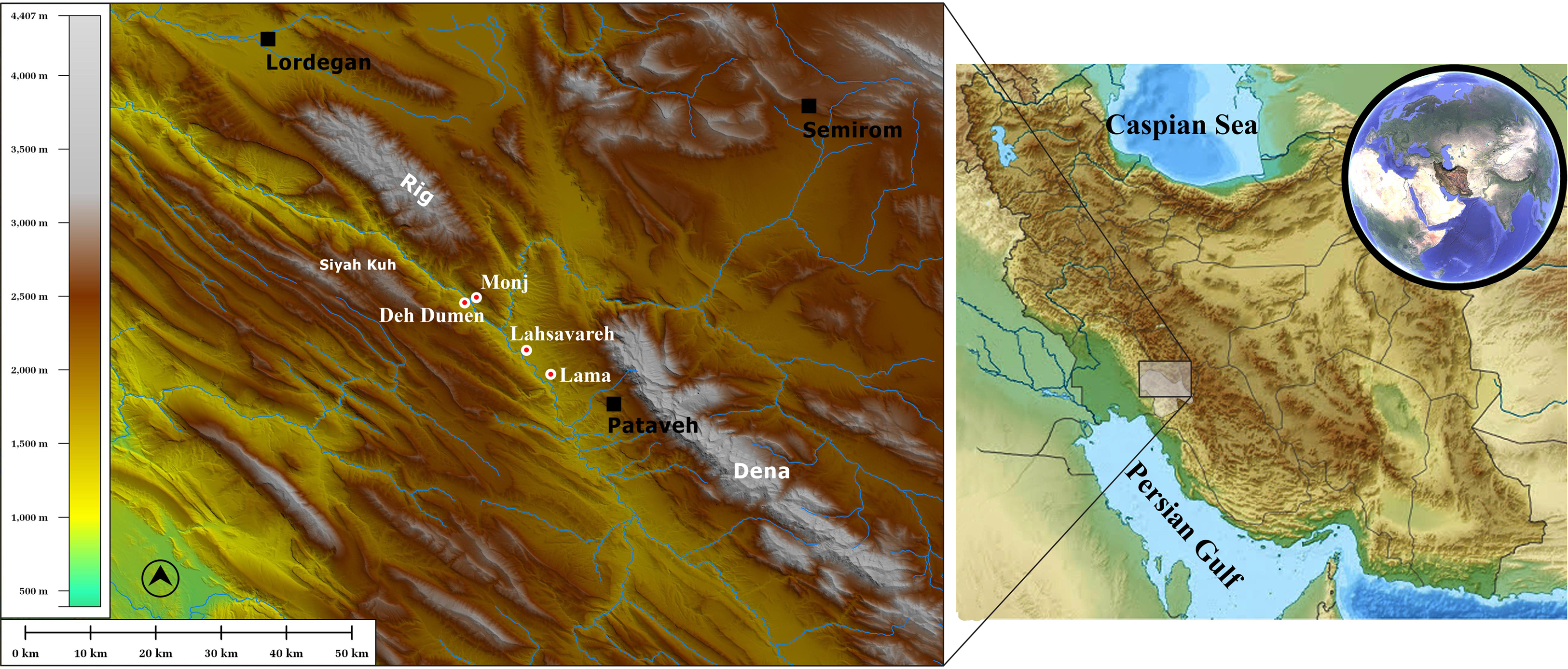
The Deh Dumen cemetery is located approximately 100 m east of the modern village of the same name, within the Bashar River basin in the mountainous landscape of the southern Zagros (Figure 1). As the site lies within the lands of Deh Dumen (Deh-e Pāyin) village, it has become known by this name. Due to its location within the inundation zone of the Khersan 3 Dam reservoir, the cemetery has been the subject of rescue excavations conducted over four seasons by the second author of this paper in 2013, 2016, 2019, and 2021 (Maghsoud et al. Reference Maghsoud, Koochakzaei and Naseri2026; Naseri et al. Reference Naseri, Khanipour, Arimatsu, Kavosh and Sołtysiak2019; Oudbashi et al. Reference Oudbashi, Naseri, Cultrone, Egartner and Arizzi2021, Reference Oudbashi, Naseri and Asadi Hasanvand2024).
Location of the Deh Dumen, Lahsavareh, Lama, and Monj cemeteries.

Figure 1. Long description
The map displays a topographic view of a region in Iran, highlighting several archaeological sites. Key locations marked on the map include Lordegan, Semirom, Rig, Siyah Kuh, Deh Dumen, Monj, Lahsavareh, Lama, Pataveh, and Dena. The map uses color shading to represent elevation, with a scale bar indicating heights from 500 to 4,000 meters. An inset map on the right shows the broader geographic context within Iran, with the Caspian Sea and the Persian Gulf labeled. The main map includes a compass rose for orientation.
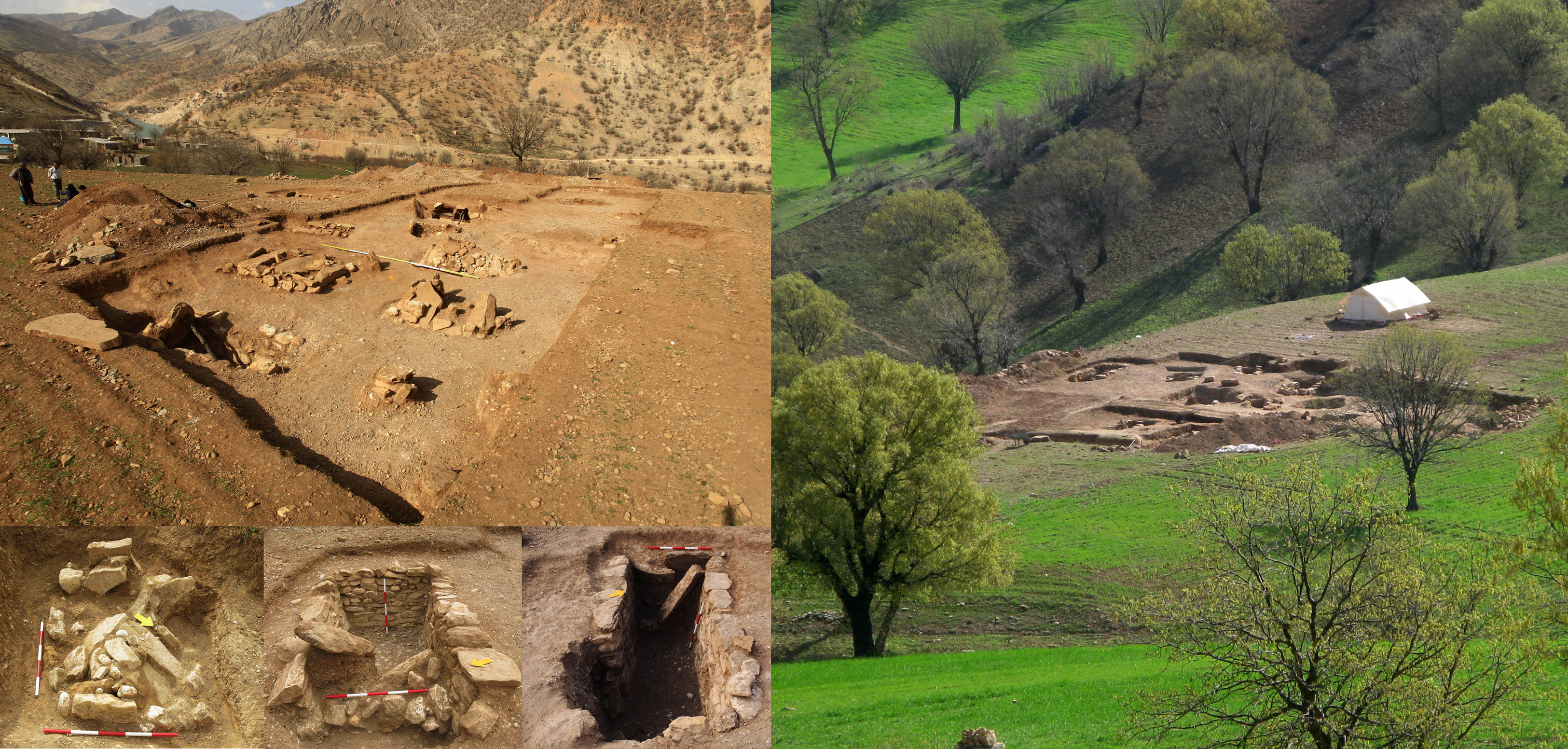
During the first season, 15 stone-built tombs were identified and excavated, followed during the second season by 11, during the third season by 10, and during the fourth by 6 further examples (Figure 2). In addition, several jar burials were also discovered. The results indicate a wide spatial and temporal distribution of burials across an area of approximately 20 hectares, suggesting long-term and repeated use of the cemetery (Miszkiewicz et al. Reference Miszkiewicz, Stewart, Naseri and Sołtysiak2022; Sołtysiak and Naseri Reference Sołtysiak and Naseri2017; Sołtysiak et al. Reference Sołtysiak, Naseri and Najafi2019).
General view of the Deh Dumen cemetery showing the excavated trenches and grave architecture.

The Lahsavareh cemetery
The Lahsavareh cemetery is located near the modern village of the same name in the Bashar River basin of southwestern Iran (Figure 1). The site came to archaeological attention due to its position within the projected flood zone of the Khersan 3 Dam, prompting a rescue excavation carried out by the second author in 2020 (Naseri et al. Reference Naseri, Najafi, Mahjoub, Tavakoli Mehr, Kavosh and Miri2020).
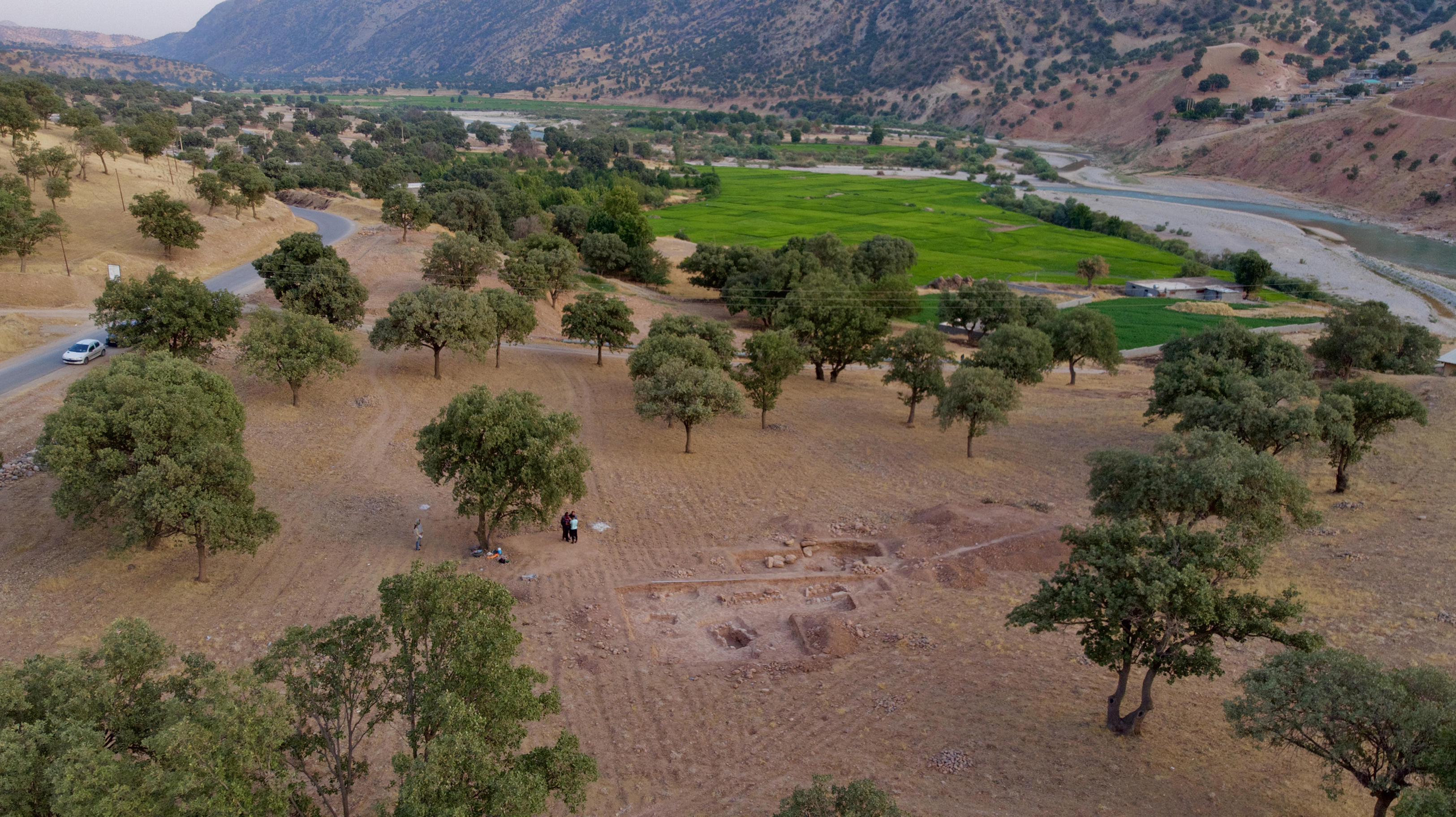
During this season, four 5 × 5 m trenches were excavated at the site. A total of 12 graves were discovered during the excavations (Figure 3), but no associated residential zones were identified. As a result, artifacts and burial data are the only remaining material evidence of the community associated with this cemetery. All excavated graves were built from stone. The construction process usually began with digging a burial pit in the ground, then dry stone walls were built inside the pit, a roof was placed to complete the burial chamber, and then burials took place in these graves.
General view of the Lahsavareh cemetery showing the excavated trenches.

The Monj cemetery
To the east of the Deh Dumen cemetery, on the eastern bank of the Bashar River, lies the modern village of Monj. Within this area, treasure hunters have looted several graves. Archaeological materials were subsequently collected from one of these looted burials, including sherds and several metal artifacts, and transferred to the Kohgiluyeh and Boyer-Ahmad Provincial Cultural Heritage, Tourism, and Handicrafts Organization.
Despite the disturbed condition of the graves, the architectural remains and associated finds suggest the presence of a cemetery dating to the first half of the third millennium BC in the vicinity of Monj. Due to the absence of systematic archaeological excavation, however, burial practices remain poorly understood, and the overall composition of the material assemblage from this cemetery is largely unknown.
The Lama cemetery
The Lama cemetery is located below the modern village of Lama, with the Bashar River flowing approximately 200 m south to southwest of the site (Figure 1). The cemetery has been excavated over three seasons, during which 73 graves were excavated (Jafari Reference Jafari, Azizi-Kharanaghi, Khanipour and Naseri2014; Rezvani et al. Reference Rezvani, Roustaei, Azadi and Qezelbash2007). All graves at Lama were built with stone, and there is evidence for the reuse of some graves for multiple burials. Although the grave structures are similar, differences in archaeological material suggest that the cemetery was active over a long period of time.
The radiocarbon chronology of the Bashar Valley
Given the paucity of reliable absolute chronologies for Elamite sites, radiocarbon dating of the cemeteries of Deh Dumen and Lahsavareh plays an important role in establishing a reliable time frame for dating the contemporaneous sites in the region. For this purpose, 4 samples from Deh Dumen and 2 samples from Lahsavareh were selected for 14C dating. Radiocarbon analyses were performed in accredited laboratories at the Curt Engelhorn Centre in Heidelberg in Germany, the Poznań Radiocarbon Laboratory and Keck Carbon Cycle AMS Facility, University of California, to establish a reliable absolute chronology for the investigated cemeteries.
Before analysis, human bone samples were undergoing standard pretreatment procedures designed for the isolation and purification of collagen, following protocols optimized for ancient materials. The bone matrix was first demineralized in dilute hydrochloric acid (HCl) to remove inorganic components, after which the samples were repeatedly rinsed with ultrapure water. If necessary, an alkaline treatment using sodium hydroxide (NaOH) was applied to remove humic acids and other possible contaminants. The remaining organic fraction was then gelatinized in a weakly acidic solution at elevated temperatures (typically 58–60 °C). After gelatinization, the solution was filtered to remove particulate matter and subsequently freeze-dried to obtain pure collagen suitable for radiocarbon dating.
The extracted collagen was burned to produce CO2, which was then reduced to graphite using a hydrogen reduction method with iron powder as a catalyst. The resulting graphite was compressed onto aluminum targets and loaded into a MICADAS AMS instrument for measurement. Radiocarbon ages were determined by measuring the 14C/12C ratios under standard operating conditions. In addition, stable carbon isotope ratios (δ13C) were measured for each sample to correct for isotopic fractionation and to assess collagen preservation and sample quality. Radiocarbon dates were calibrated using OxCal version 4.4 and the IntCal20 calibration curve (Reimer et al. Reference Reimer, Austin, Bard, Bayliss, Blackwell, Bronk Ramsey and Talamo2020). All calibrated age ranges are reported at the 95.4% probability level (2σ).
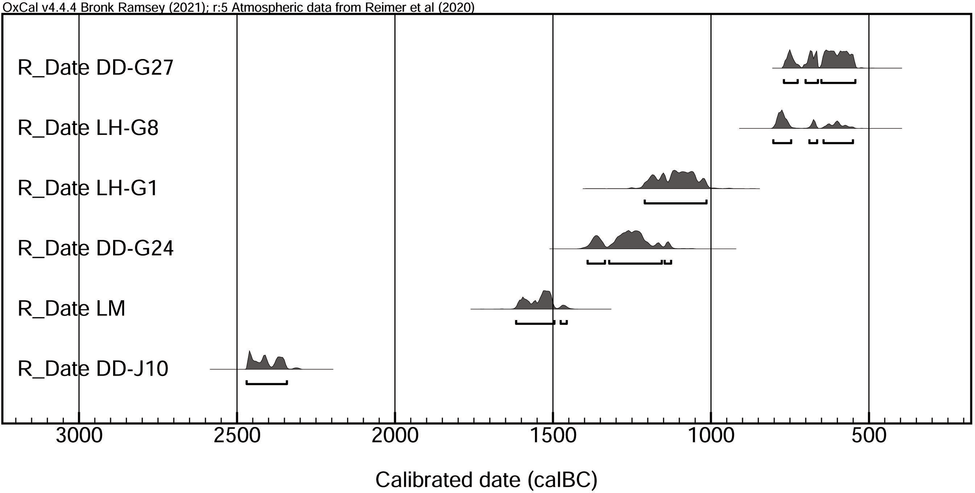
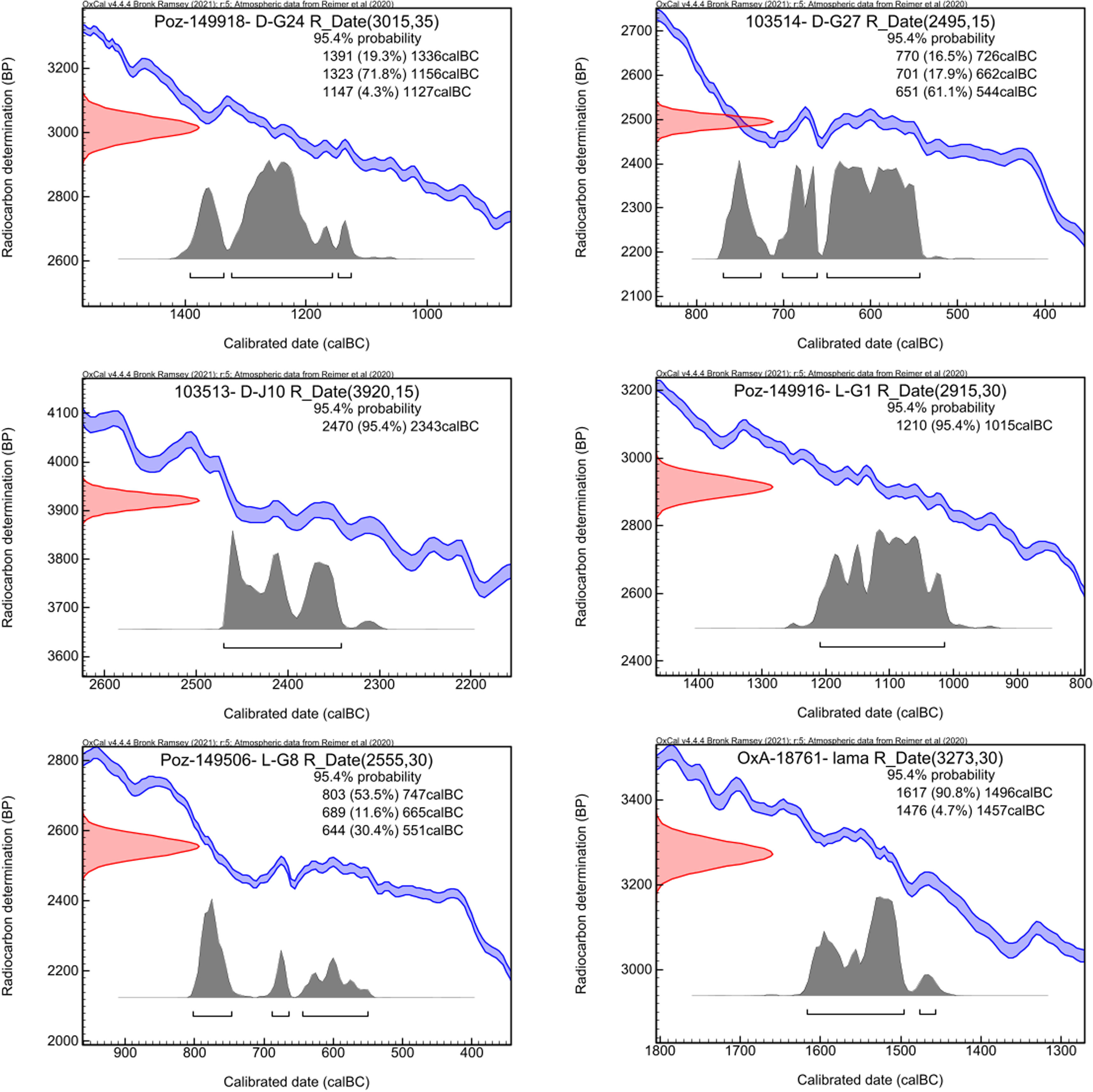
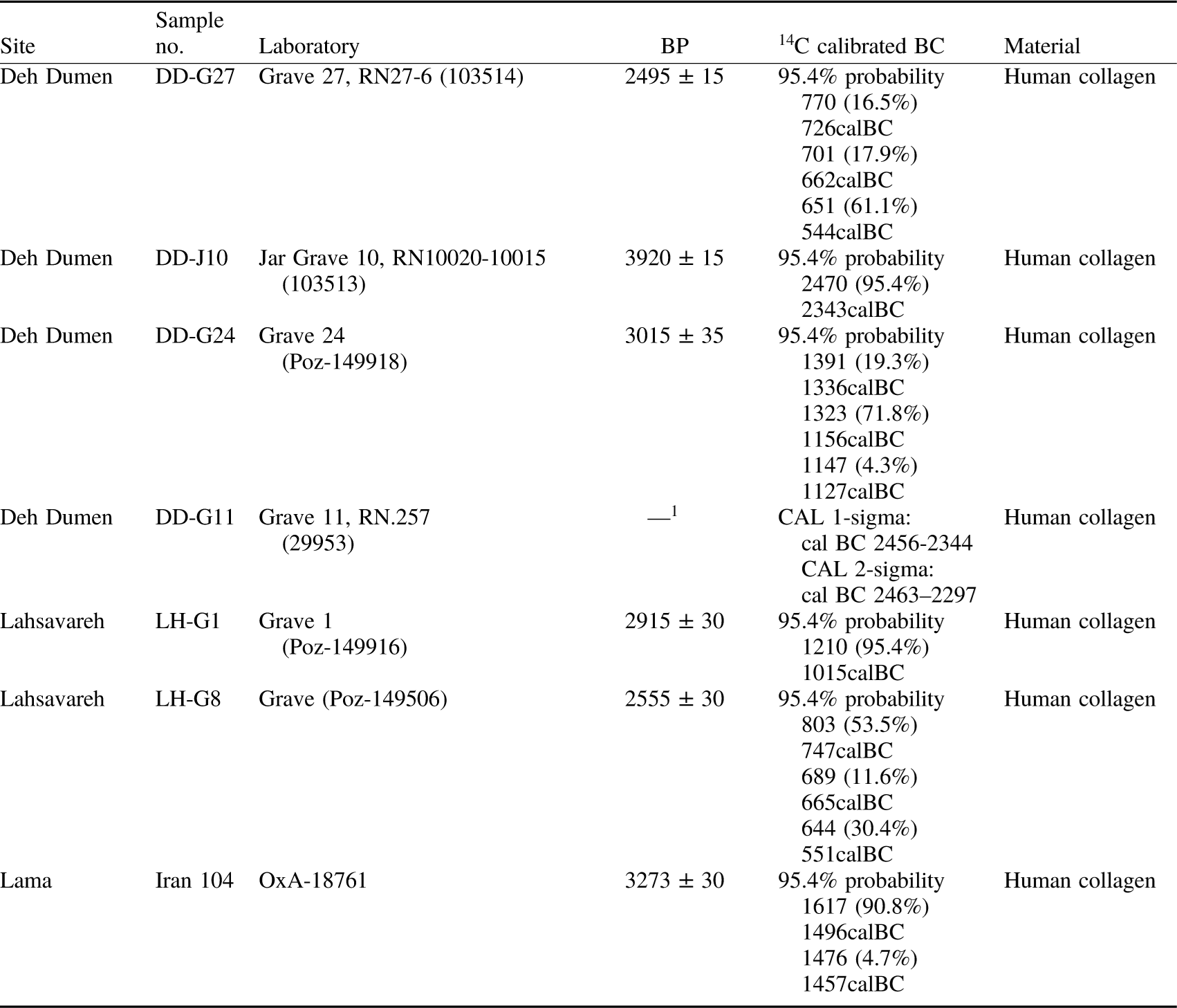
During the first excavation season at Deh Dumen, three human bone samples were selected from Graves 11, 12, and 15 among the 15 excavated graves and submitted for analysis to the Curt Engelhorn Centre in Germany. Two of these samples lacked sufficient collagen for reliable dating, and only the sample from Grave 11 yielded a valid result, producing a calibrated date range of 2463–2297 BCE. A second sample, taken from Grave 24 during the second excavation season, was analyzed at the Poznań Radiocarbon Laboratory and produced a calibrated date of 1391–1127 BCE. Two additional samples were selected during the third excavation season: one from Grave 27 in Trench 9 and another from a jar burial uncovered in Trench 10. These samples were analyzed at the Keck Carbon Cycle AMS Facility and yielded calibrated dates of 770–544 BCE and 2470–2343 BCE, respectively.
At the Lahsavareh cemetery, two radiocarbon samples were analyzed at the Poznań Radiocarbon Laboratory. Owing to the markedly distinct grave goods associated with Grave 1 compared to the other excavated burials, one sample was selected from this grave, resulting in a calibrated date range of 1210–1015 BCE. From the remaining 11 graves, which displayed broadly similar assemblages, a sample from Grave 8—assessed as having better collagen preservation—was selected for analysis. This sample produced a calibrated date of 803–551 BCE (Figures 4 and 5; Table 1).
14C from Bashar River basin: combined probability distribution plot.

Radiocarbon dates from Bashar River basin: individual OxCal calibration plots.

Radiocarbon dates from Bashar River basin, the calibration is based on OxCal v4.4.4.

Table 1. Long description
The table presents radiocarbon dating results from different sites, focusing on sample numbers, laboratories, BP values, calibrated BC dates, and material types. It includes data from sites such as Deh Dumen, Lahsavareh, and Lama. The table has 8 rows and 6 columns. Column headers are Site, Sample no., Laboratory, BP, 14C calibrated BC, and Material. Row 1: Site, Deh Dumen; Sample no., DD-G27; Laboratory, Grave 27, RN27-6 (103513); BP, 2495 ± 15; 14C calibrated BC, 95.4% probability 770 (16.5%) 726calBC 701 (17.9%) 662calBC 651 (61.1%) 544calBC; Material, Human collagen. Row 2: Site, Deh Dumen; Sample no., DD-J10; Laboratory, Jar Grave 10, RN10020-10015 (103514); BP, 3920 ± 15; 14C calibrated BC, 95.4% probability 2470 (95.4%) 2343calBC; Material, Human collagen. Row 3: Site, Deh Dumen; Sample no., DD-G24; Laboratory, Grave 24 (Poz-149918); BP, 3015 ± 35; 14C calibrated BC, 95.4% probability 1391 (19.3%) 1336calBC 1323 (71.8%) 1156calBC 1147 (4.3%) 1127calBC; Material, Human collagen. Row 4: Site, Deh Dumen; Sample no., DD-G11; Laboratory, Grave 11, RN.257 (29953); BP, —1; 14C calibrated BC, CAL 1-sigma: cal BC 2456-2344 CAL 2-sigma: cal BC 2463-2297; Material, Human collagen. Row 5: Site, Lahsavareh; Sample no., LH-G1; Laboratory, Grave 1 (Poz-149916); BP, 2915 ± 30; 14C calibrated BC, 95.4% probability 1210 (95.4%) 1015calBC; Material, Human collagen. Row 6: Site, Lahsavareh; Sample no., LH-G8; Laboratory, Grave (Poz-149506); BP, 2555 ± 30; 14C calibrated BC, 95.4% probability 803 (53.5%) 747calBC 689 (11.6%) 665calBC 644 (30.4%) 551calBC; Material, Human collagen. Row 7: Site, Lama; Sample no., OxA-18761; Laboratory, Iran 104; BP, 3273 ± 30; 14C calibrated BC, 95.4% probability 1617 (90.8%) 1496calBC 1476 (4.7%) 1457calBC; Material, Human collagen.
As noted above, the third cemetery excavated within the Bashar River basin is Lama. To date, only a single radiocarbon date has been published for this site, yielding a calibrated range of 1617–1457 BCE (Ramaroli et al. Reference Ramaroli, Hamilton, Ditchfield, Fazeli, Aali, Coningham and Pollard2010).
Chronological sequence of the Bashar River basin
Archaeological excavations conducted in different parts of the Deh Dumen cemetery resulted in the recovery of a diverse assemblage of cultural materials. Detailed comparative analysis and classification of these finds made it possible to distinguish four discrete cultural phases. At the Lahsavareh cemetery, analysis of the cultural materials recovered during the first excavation season suggests that most graves are relatively homogeneous in terms of pottery and grave goods. However, Grave No. 1 yielded a distinct assemblage that differs markedly from the other burials, indicating the presence of at least two identifiable cultural phases at this cemetery.
At the Lama cemetery, a total of 73 graves were identified and excavated over three seasons of fieldwork. The associated ceramic, metal and stone artifacts indicate that the cemetery was in use over a relatively long period, during which continuity in burial traditions can be observed. Based on similarities and differences in the recovered cultural materials, together with absolute dating results, a chronological framework for the cemeteries of the Bashar River basin can be proposed as follows.
Late fourth to early third millennium BCE: Proto-Elamite period
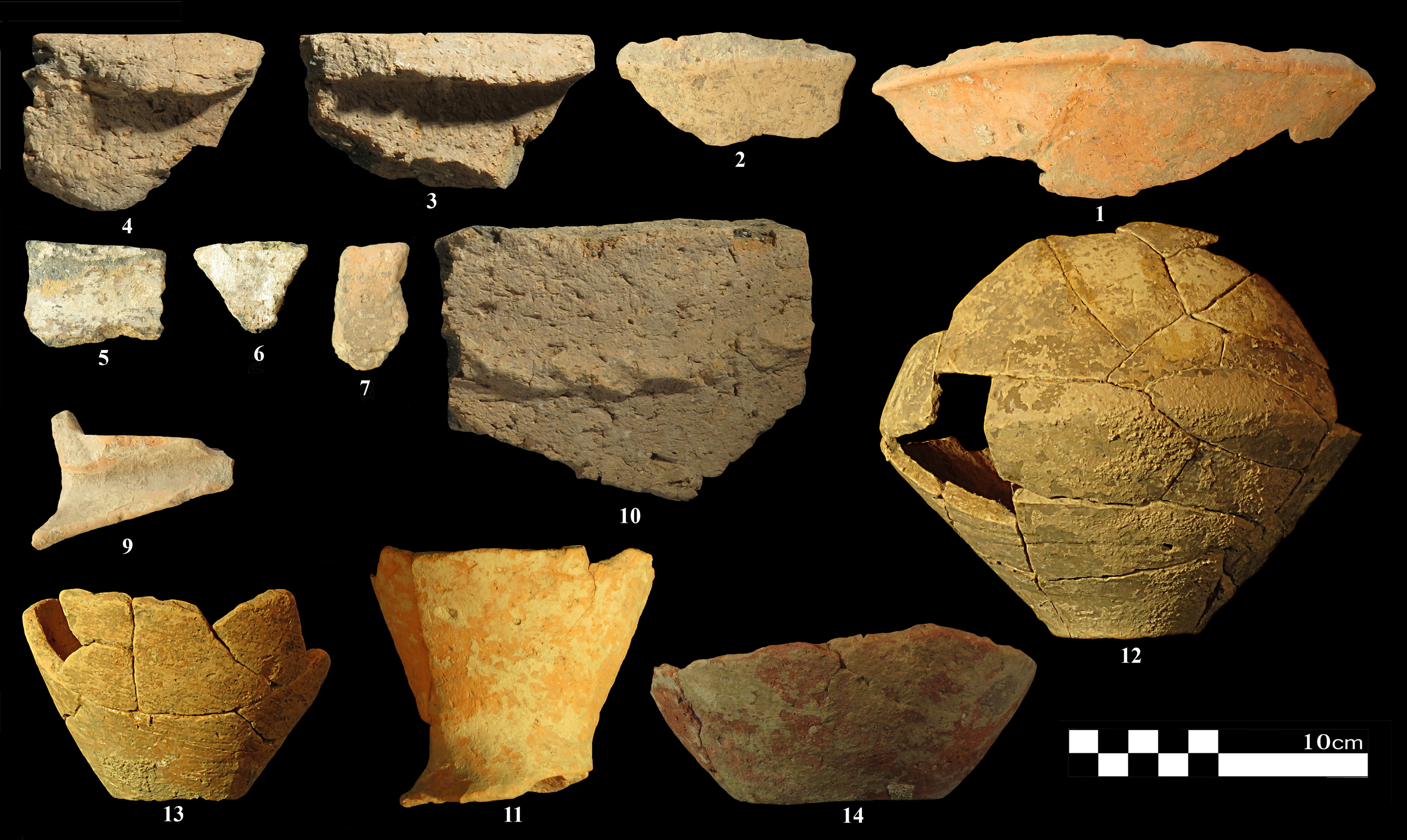
During the second excavation season at the Deh Dumen cemetery, limited remains of stone-built architectural features were uncovered. These structures appear to be associated with mobile or semi-nomadic communities (Naseri and Khanipour Reference Naseri and Khanipour2026). The ceramic assemblage recovered from these contexts (Figure 6) includes bevelled-rim bowls (Figure 6, No. 1 and 2), and nose lugs. Comparable pottery forms have previously been reported from other Proto-Elamite sites in Iran, including Susa (Le Brun Reference Le Brun1971: 177, fig. 65: 7–8), Tol-e Malyan (Nickolas Reference Nickolas1990, 56–57; Sumner Reference Sumner2003, fig. 22: No. I), Tol-e Kureh (Alden Reference Alden and Sumner2003: 196; Table D1), Tol-e Nurabad (Weeks et al. Reference Weeks, Alizadeh, Niakan, Alamdari, Khosrowzadeh, Zeidi, Potts and Roustaei2006: figs. 3.100–102), Tol-e Spid (Petrie et al. Reference Petrie, Asgari Chaverdi, Seyedin, Potts and Roustaei2006) and Tol-e Gap Kenareh (Khanipour et al. Reference Khanipour, Naseri and Nouruzi2017, fig. 10). On the basis of this relative ceramic chronology, it appears that this part of the Bashar River basin was first occupied by Proto-Elamite mobile communities (Naseri and Khanipour Reference Naseri and Khanipour2026). As no radiocarbon dates are currently available for this Proto-Elamite phase at Deh Dumen, the proposed chronological placement is based on ceramic parallels and published radiocarbon evidence from comparable sites in southwestern Iran. Absolute radiocarbon dates obtained from sites such as Malyan (Sumner Reference Sumner2003, tab. 13), Nurabad (Weeks et al. Reference Weeks, Alizadeh, Niakan, Alamdari, Khosrowzadeh, Zeidi, Potts and Roustaei2006, tab. 3.2), and Tol-e Spid (Petrie et al. Reference Petrie, Asgari Chaverdi, Seyedin, Potts and Roustaei2006, tab 4.4) place this phase approximately between 3200 and 2800 BCE.
Proto-Elamite pottery from Deh Dumen.

First half of the third millennium BCE
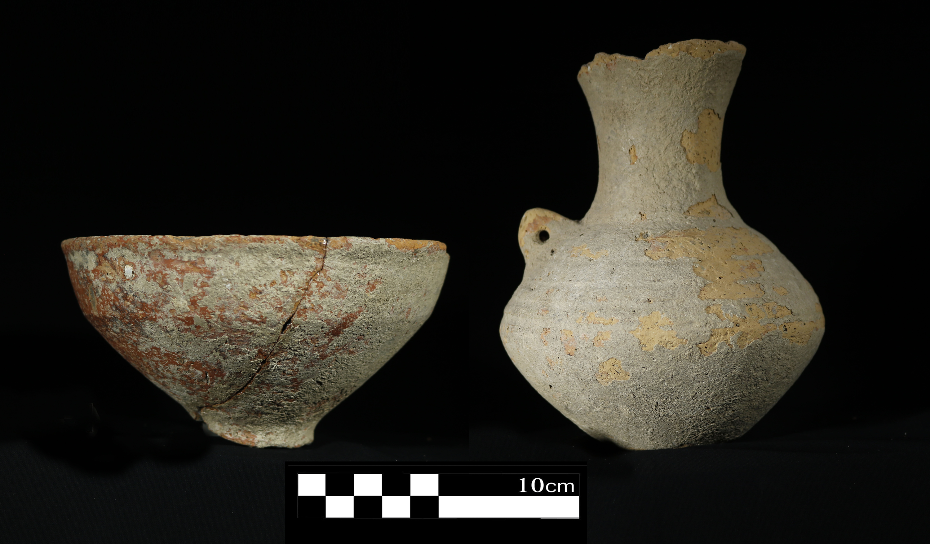
The oldest identified graves in this area were found at the Monj cemetery. As mentioned earlier, no systematic archaeological excavations have been carried out in the Monj cemetery so far, and the available information is based only on artifacts recovered from unauthorized excavations of this site. These findings include a number of metal objects and pottery vessels (Figure 7) that, although lacking archaeological context, can be attributed to the first half of the third millennium BC in terms of morphological features and construction techniques. However, this dating is based solely on comparative studies of pottery and other finds recovered from the surface or unauthorized excavations, and there is no stratigraphic or absolute dating evidence to confirm it. Therefore, targeted archaeological excavations, along with sampling for absolute dating and a detailed examination of the burial grounds, are necessary to determine the chronology and cultural status of this cemetery.
Pottery from Monj Cemetery.

Second half of the third millennium BCE: Old Elamite period
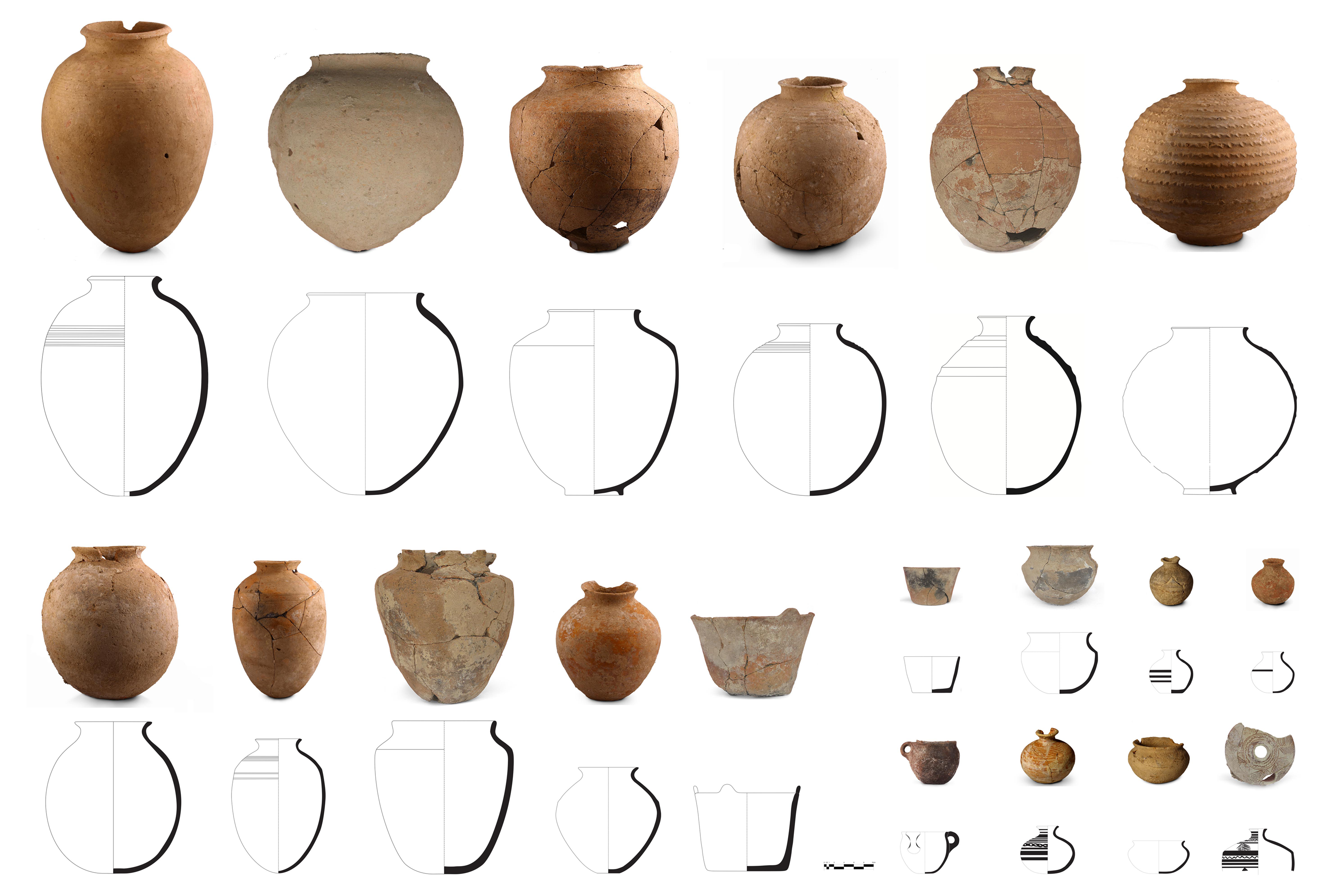
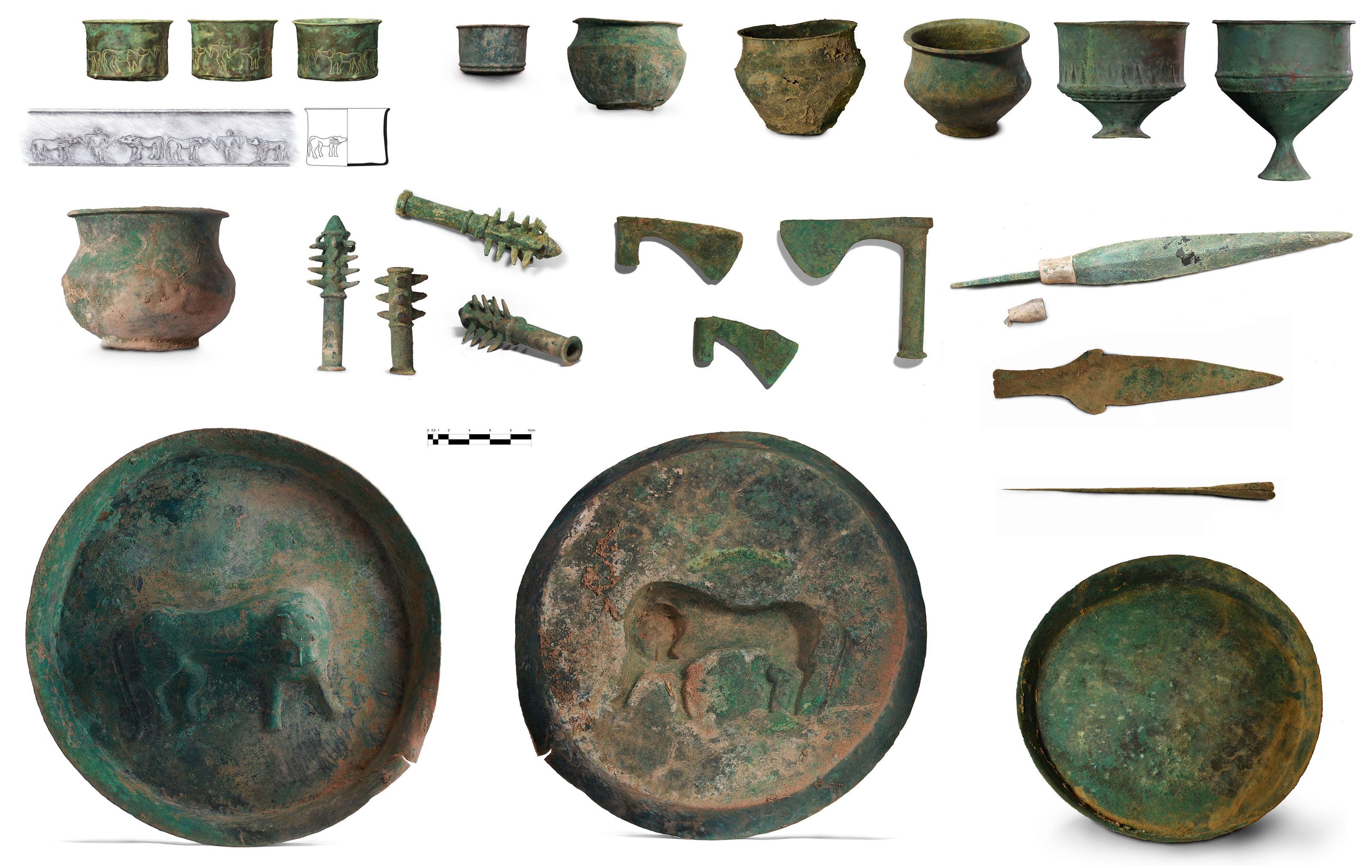
Relative comparison and absolute chronology show that most of the excavated graves in Deh Dumen date back to the second half of the third millennium BCE, including graves 1 to 22, and 30 to 42. Also, all jar burials date back to this period. In terms of the color of the paste, the pottery of this period can be divided into three groups: red, buff, and gray, with the majority of them being red. Although most of the pottery is plain, three techniques of decoration including painting, appliqué, and incision were used (Figure 8). The motifs were zoomorphic or geometric and were executed using black and red pigments. The pottery assemblage closely parallels examples from Bani Surmeh (Haerinck and Overlaet Reference Haerinck and Overlaet2006: 23, figs. 7, 26–27) and the Susa D phase (Carter Reference Carter1979, 452), supporting a date in the second half of the third millennium BCE. The excavation also yielded many metal artifacts that can be classified into four functional categories: weapons, metal vessels, jewelry, and musical instruments (Figure 9). The axe recovered from Grave 15 bears close resemblance to the Susa D and Bani Surmeh assemblages (Le Breton Reference Le Breton1957; Haerinck and Overlaet Reference Haerinck and Overlaet2006). Geochemical data further reveal that the copper used at Deh Dumen originated from multiple sources. While several artifacts correspond to ore zones within the Iranian Plateau, three artifacts were traced to sources in the Indus Valley. This represents the first documented evidence for the circulation of Indus-region metals in western Iran and provides strong support for socioeconomic interactions between western Iran and the Harappan civilization during the mid–third millennium BCE (Oudbashi et al. Reference Oudbashi, Renson and Naseri2023).
Old Elamite pottery from the Deh Dumen cemetery.

Old Elamite metal artifacts from the Deh Dumen cemetery.

Figure 9. Long description
Panel A: Various metal vessels, including jars, bowls, and vases, with intricate designs and patina. Panel B: Tools and weapons such as axes, chisels, and spearheads, some with decorative elements. Panel C: Large circular plates with raised designs, including depictions of animals.
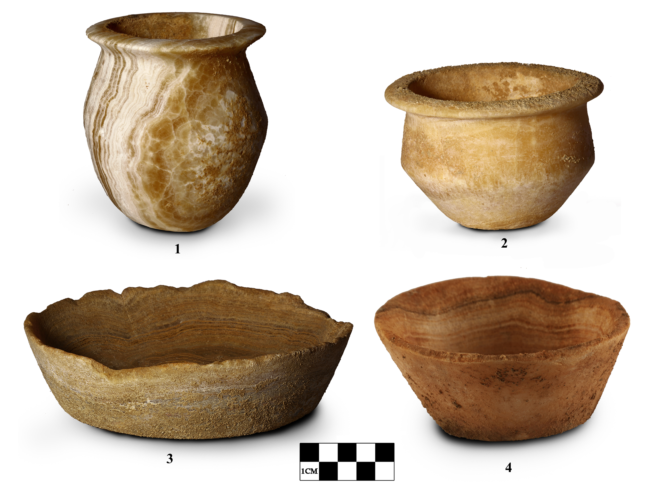
In addition to metal artifacts, calcite stone vessels were recovered from most of the graves excavated during this phase (Figure 10). A chlorite vessel was also identified. The presence of these stone containers reflects long-distance exchange networks that were well established during the Bronze Age, through which prestige goods and exotic materials were circulated into the Bashar River basin.
Old Elamite calcite vessels from the Deh Dumen cemetery.

Second half of the second millennium BCE: Middle Elamite period
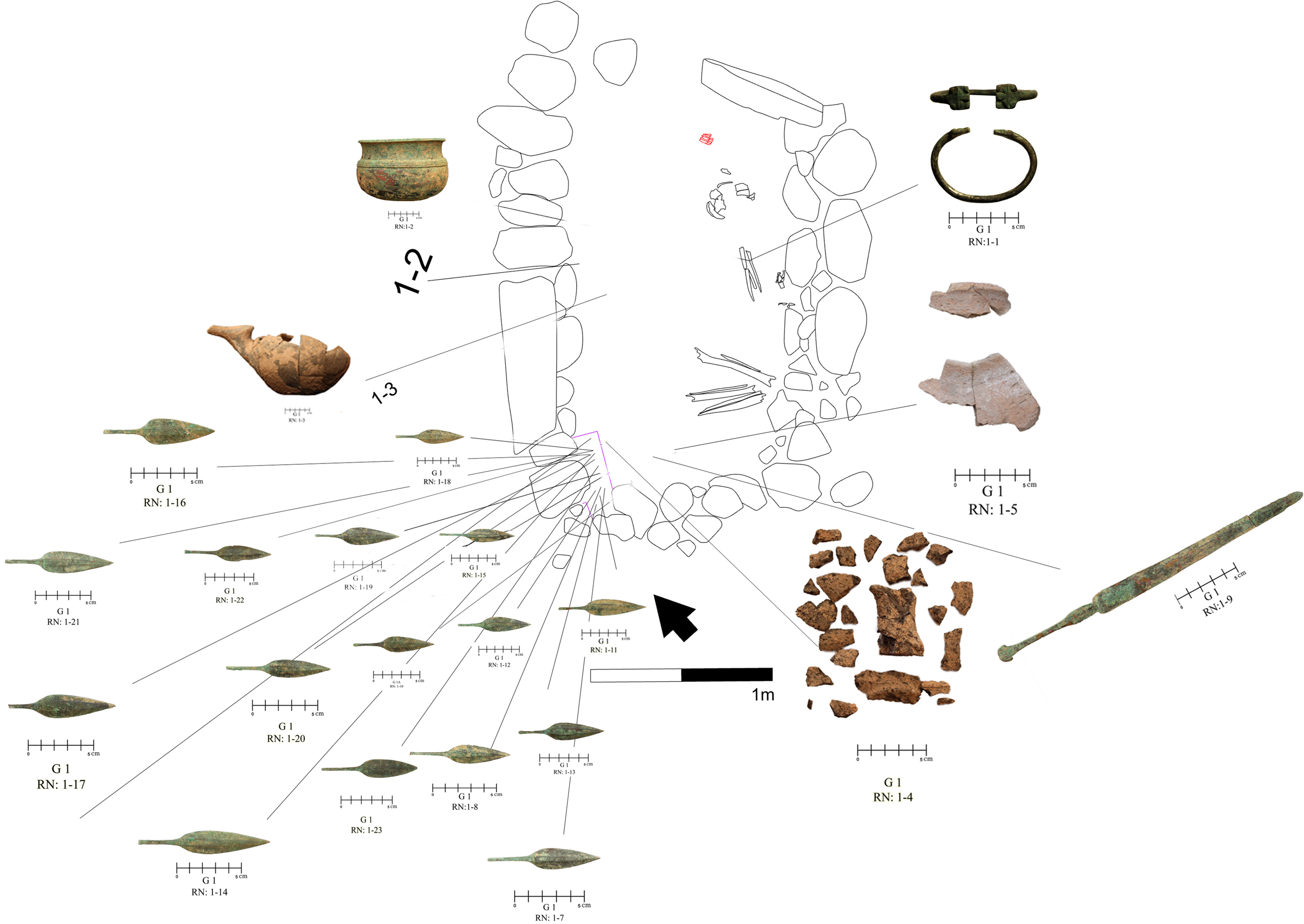
The period between approximately 1500 and 1100 BCE is conventionally identified as the Middle Elamite period (Carter and Stolper Reference Carter and Stolper1984, Tab. 4; de Miroschedji Reference de Miroschedji1981a, Tab. 2; Potts Reference Potts2016; Steve et al. Reference Steve, Gasche and De Meyer1980, 91–107). Based on absolute radiocarbon chronology and relative comparisons of the archaeological assemblages, the cultural materials recovered from the second excavation season at the Deh Dumen Cemetery—specifically Graves 23 to 26—as well as Grave 1 at the Lahsavareh Cemetery (Figure 11) can be securely assigned to this period.
Distribution of grave goods in Grave 1, Lahsavareh cemetery.

Figure 11. Long description
Panel A: A skeletal figure is surrounded by various grave goods. The items include pottery, tools, and other artifacts. The skeletal figure is positioned centrally with grave goods radiating outwards. Panel B: Close-up views of individual grave goods are shown around the skeletal figure. These include pottery, tools, and other artifacts. Each item is labeled with identifiers such as G 1 RN 1-1, G 1 RN 1-4, and so on. The scale bar indicates a measurement of 1 meter.
The pottery assemblage of this period can be divided into two broad technological groups. The first consists of handmade vessels tempered with fine sand. These ceramics are generally fragile, poorly fired, and entirely undecorated. The second group comprises well-fired wares, many of which are decorated. Compared to the preceding period, ceramic decoration becomes more frequent during the Middle Elamite phase, with geometric motifs applied to the exterior surfaces of vessels (Figure 12). These designs predominantly consist of horizontal bands and wavy lines. Another characteristic ceramic form of this period is the handled spouted jug, examples of which were recovered from both the Deh Dumen and Lama cemeteries. It seems that the production of metal vessels during the Middle Elamite period was limited and metal was used primarily for making personal ornaments or weapons. It is noteworthy that no calcite vessels have been discovered from the sites attributed to this period, which suggests that the importation of calcite vessels was obsolete.
Middle Elamite pottery from the Deh Dumen cemetery.

The architectural structure of the graves remains broadly consistent with that of earlier phases. Multiple burials within individual graves were common. Based on the arrangement of skeletal remains and associated grave goods, it appears that the graves were reopened for subsequent interments. In such cases, the skeletal remains and burial offerings of earlier individuals were moved toward the rear of the burial chamber to accommodate new burials.
First half of the first millennium BCE: Neo-Elamite period
The period from approximately 1000 BCE until the beginning of the Achaemenid era is identified as the Neo-Elamite period. Absolute radiocarbon dates and comparative analysis of cultural materials from the Deh Dumen, Lahsavareh, and Lama cemeteries indicate that burial activities continued at these sites throughout this period.
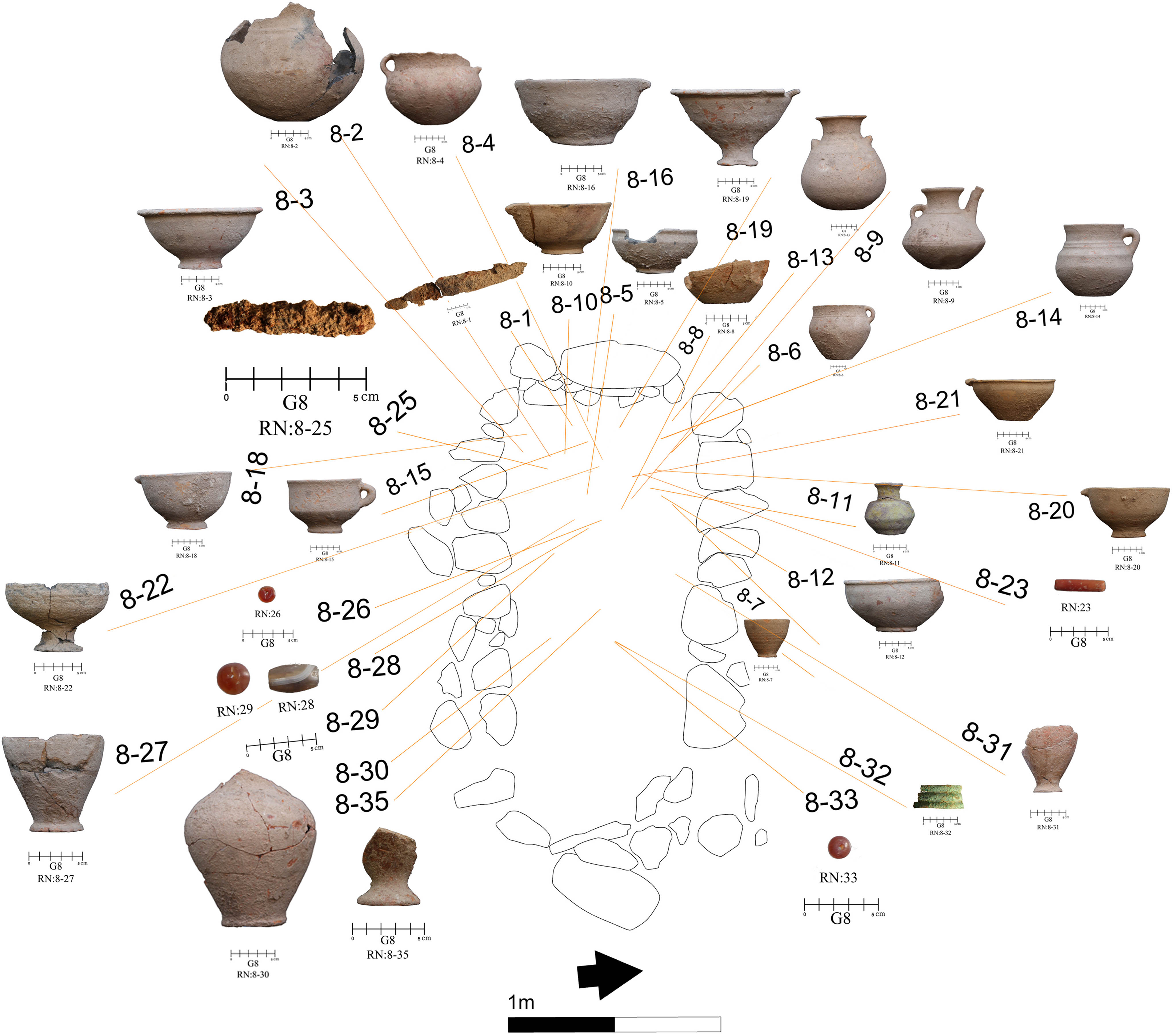
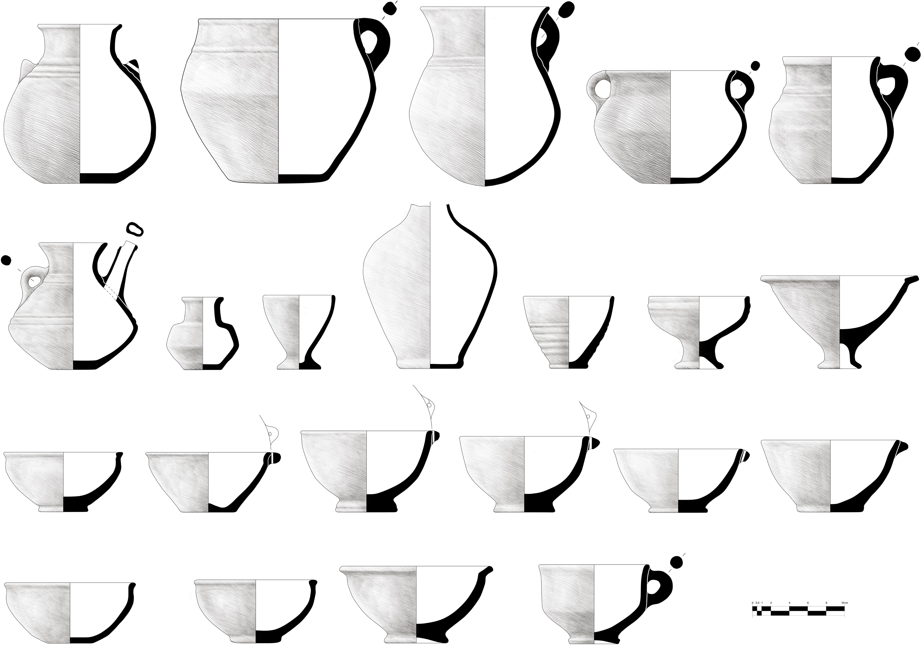
At Deh Dumen, only two graves (Graves 27 and 28) can be assigned to the Neo-Elamite period. Radiocarbon dating of Grave 27 yielded a calibrated age range of 770–544 BCE. In contrast, the majority of the graves at Lahsavareh belong to this period (Figures 13 and 14), with radiocarbon dates ranging between 803–551 BCE. The Lama Cemetery has also produced numerous artifacts comparable to those from Lahsavareh, indicating that it too was used for burial during the Neo-Elamite period.
Distribution of grave goods in Grave 8, Lahsavareh cemetery.

Neo-Elamite pottery from the Lahsavareh cemetery.

Figure 14. Long description
Panel A: A drawing of a pottery vessel with a wide body and a narrow neck, featuring a handle on the side. Panel B: A drawing of a pottery vessel with a rounded body and a small handle. Panel C: A drawing of a pottery vessel with a narrow neck and a wide body, featuring a handle on the side. Panel D: A drawing of a pottery vessel with a wide body and a small handle. Panel E: A drawing of a pottery vessel with a narrow neck and a wide body, featuring a handle on the side. Panel F: A drawing of a pottery vessel with a wide body and a small handle. Panel G: A drawing of a pottery vessel with a narrow neck and a wide body, featuring a handle on the side. Panel H: A drawing of a pottery vessel with a wide body and a small handle. Panel I: A drawing of a pottery vessel with a narrow neck and a wide body, featuring a handle on the side. Panel J: A drawing of a pottery vessel with a wide body and a small handle. Panel K: A drawing of a pottery vessel with a narrow neck and a wide body, featuring a handle on the side. Panel L: A drawing of a pottery vessel with a wide body and a small handle. Panel M: A drawing of a pottery vessel with a narrow neck and a wide body, featuring a handle on the side. Panel N: A drawing of a pottery vessel with a wide body and a small handle. Panel O: A drawing of a pottery vessel with a narrow neck and a wide body, featuring a handle on the side. Panel P: A drawing of a pottery vessel with a wide body and a small handle.
The archaeological assemblage of this phase includes ceramic vessels as well as stone and metal artifacts. One of the notable features of this period is the widespread use of iron (Figure 15). The production and use of iron artifacts seem to have become common, and a significant proportion of the weapons recovered from these graves were made of iron, indicating wider technological advances in the first half of the first millennium BCE.
Neo-Elamite metal artifacts from the Lahsavareh cemetery.

One notable find is a glazed vessel (Figure 13, No. 8–11) recovered from Grave 8 at Lahsavareh. Its distinctive color, glaze, craftsmanship, and shape clearly distinguish it from the rest of the assemblage, indicating that it was not produced locally but was imported from another region. The manufacture of glazed pottery represents a significant technological innovation that required specialized skill and expertise. The presence of glazed ceramics at Lahsavareh, Susa (De Miroschedji Reference de Miroschedji1981a: 77, fig. 21, No. 1) and Jubaji (Shishegar Reference Shishegar2015) suggests that Elamite societies were engaged in limited production of such vessels in the first half of the first millennium BCE. The Neo-Elamite ceramic assemblage from Susa is primarily known from the VR II sequence Neo-Elamite I from layers 9–8 and Neo-Elamite II from layers 7B–A as well as from the VR-Apadana sequence (layers 7C and 7B–A) (De Miroschedji Reference de Miroschedji1981b). Comparable materials have also been recovered from the later phases at Chogha Zanbil, specifically Layer 2 (10th–9th centuries BCE) and Layer 1 (8th–7th centuries BCE), which are consistent with the assemblages from Susa (Mofidi-Nasrabadi Reference Mofidi-Nasrabadi2007: 90). Together, the sequences from Susa and Chogha Zanbil constitute the primary reference frameworks for identifying the final phases of the Neo-Elamite period. In this context, the pottery recovered from Lahsavareh provides an important basis for understanding Neo-Elamite ceramic traditions in the highland regions of southwestern Iran.
Discussion
For over a century, historians, archaeologists, and linguists have studied Elam, the oldest known political and state entity on the Iran (Álvarez-Mon Reference Álvarez-Mon and Potts2012; Álvarez-Mon et al. Reference Álvarez-Mon, Basello, Wicks, Álvarez-Mon, Basello and Wicks2018, 1; Potts Reference Potts2016; Stolper Reference Stolper, Carter and Stolper1984; Zadok Reference Zadok, Álvarez-Mon, Basello and Wicks2018). However, a number of fundamental issues of this period remain contested. One of them concerns the definition of the geographical extent of Elam’s territory in different periods (Álvarez-Mon Reference Álvarez-Mon2020). While some scholars have restricted Elam to a relatively limited area in southwestern Iran, others have proposed a much broader territorial scope that encompassed large parts of the Iranian Plateau (e.g., Potts Reference Potts2004, Reference Potts2016; Stolper Reference Stolper1982; Steinkeller Reference Steinkeller1982, Reference Steinkeller2006, Reference Steinkeller2007; Vallat Reference Vallat1993). However, what is clear is that the extent of Elam’s territory was not constant and underwent significant political and geographical changes from the Old Elamite to the Neo-Elamite period. In any case, the Bashar River basin can be considered part of the Elamite territory.
Excavations at the cemeteries of Deh Dumen, Lahsavareh, and Lama indicate that the area was occupied and used by largely mobile or semi-nomadic communities from the Proto-Elamite to Neo-Elamite periods. Absolute radiocarbon dating of human remains from these cemeteries has made it possible to distinguish cultural assemblages associated with different Elamite phases and to more reliably link them to frameworks of Elamite political and historical development. Furthermore, these data significantly contribute to the refinement of regional chronologies and the reassessment of contemporaneous archaeological sites in southwestern Iran. Among the most notable finds from Deh Dumen, dating to the Old Elamite period, is a metal basin decorated with a hollow animal figure. Comparable examples have previously been reported from the Shahdad cemetery (Hakemi Reference Hakemi1977, Gs.4-7), the site of Jiroft in southeastern Iran (Majidzadeh Reference Majidzadeh2003, 156), and Tepe Hissar in northeastern Iran (Schmidt Reference Schmidt1937, fig 112). Radiocarbon dates from Deh Dumen demonstrate that these artifacts can be securely dated to approximately 2500–2200 BCE. This evidence is particularly important for revising earlier chronologies that relied primarily on stylistic comparisons.
In the metalworking traditions of western and southwestern Iran, depictions of lions or lion masks are well documented as decorative elements on personal ornaments. Since many of these artifacts come from illegal excavations or unprovenanced collections, they are often dated by scholars to the 8th and 7th centuries BCE (Muscarella Reference Muscarella1988). However, the example discovered from the Lahsavareh cemetery shows that this decorative tradition was already in use in the late 2nd millennium BCE. This finding suggests that previous chronologies proposed for some of these artifacts need to be revised.
The widespread appearance of iron artifacts in the cemeteries of Lahsavareh and Deh Dumen, dating to the Neo-Elamite period, suggests that the production and use of iron in this part of Iran was well established by about 800 BCE. At this time, iron was used primarily in the manufacture of weapons, reflecting both its mechanical properties and its increased availability. In parallel, the manufacture of glazed pottery represents a major technological innovation in ceramic production. Radiocarbon evidence from these cemeteries suggests that glazed vessels, albeit in limited quantities, began to appear around 800 BCE. Together, these developments suggest that Elamite societies in the Zagros highlands were not passive recipients of technological change, but rather actively participated in wider networks of technological transfer in the Elamite world.
Conclusion
Archaeological excavations at the cemeteries of Lama, Deh Dumen, and Lahsavareh in the southern Zagros have yielded valuable data on burial practices and material culture from the second half of the 4th millennium to the first half of the 1st millennium BCE. This time range broadly corresponds to what is conventionally described in the archaeological literature as the Bronze and the Iron Age, or as the Proto-Elamite period and the various phases of the Elamite period. Most importantly, the application of absolute radiocarbon dating to human remains from these cemeteries has, for the first time, made it possible to establish a reliable and precise sequence of burial practices in this part of the Zagros. As a result, a robust temporal framework is now available for interpreting the material culture of the region.
The radiocarbon dates obtained in this study contribute to Iranian archaeology in three main ways. First, they allow for the precise determination of the periods during which each cemetery was used. It is now possible to distinguish with much greater confidence between material assemblages belonging to the Old, Middle, and Neo-Elamite periods in this region.
Second, the absolute dating results provide important insights into technological developments, particularly in the field of metallurgy. The data show that from about 2500 BCE onwards, tin bronze production became widespread in this part of West Asia. In addition, from about 800 BCE, the production of iron artifacts was quite common. The use of glazed pottery, one of the most important innovations in ceramic production, also began in this region in the Neo-Elamite period, around 800 BCE.
Third, establishing a reliable absolute chronology for the artifacts and assemblages recovered from these cemeteries provides a valuable reference framework for dating other archaeological materials throughout Iran. Therefore, the Deh Dumen and Lahsavareh assemblages can serve as reliable comparative benchmarks for re-evaluating and dating materials obtained from sites such as Susa, the Luristan bronzes, and even assemblages from southeastern and northeastern Iran.
This research shows that radiocarbon dating is not simply a tool for determining the absolute age of burials, but also plays an important role in reconstructing cultural sequences, understanding technological changes, and establishing meaningful chronological links between different regions of the Iranian Plateau.
Acknowledgments
We gratefully acknowledge the Iranian Center for Archaeological Research for its support of the field excavations at the Deh Dumen and Lahsavareh cemeteries. We also sincerely thank all members of the excavation team across the five field seasons for their dedication and invaluable contributions.
Radiocarbon dating in the Curt Engelhorn Centre in Germany was possible thanks to a grant of the Fritz Thyssen-Stiftung awarded to Barbara Helwing for the project “ChronIran”. Radiocarbon dating conducted at the Poznań Radiocarbon Laboratory was financed by the National Science Centre (NCN), Poland, under grant No. 2016/22/M/HS3/00353.
We further acknowledge the Lundbeck Foundation GeoGenetics Centre, University of Copenhagen, Denmark, for supporting the radiocarbon analysis of the samples conducted at Keck Carbon Cycle AMS Facility, University of California, USA.