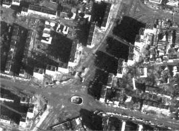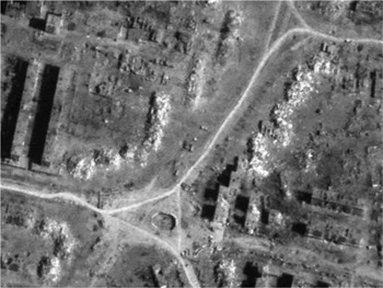


The application of satellite technology for the remote identification of potential violations of international humanitarian law (IHL) was clearly demonstrated by the selective release of US intelligence imagery over suspected mass graves in Srebrenica in 1995 and Kosovo in 1999.Footnote 1 The first open source demonstration came with the commercial release of Ikonos satellite imagery over the city of Grozny in March 2000, a month after the Russian army occupied the city during the Second Chechen War.Footnote 2 As shown in Figures 1 and 2, the near total destruction of several thousand buildings within central Grozny was irrefutably documented in graphic detail. The implications were as dramatic as they were obvious: commercial satellite imagery had now made it possible for international investigators to collect evidence on alleged war crimes remotely from the conflict zone, during active hostilities, and independent of the traditional need to secure official permission from one or more parties to the conflict.
Central Grozny (Minutka Sq.) on 16 December 1999 (Image © GeoEye).

After Russian occupation on 16 March 2000 (Image © GeoEye).

Since the release of the first commercially available very high resolution (VHR) satellite imagery in late 1999Footnote 3 there has been a growing awareness of the potential of this space technology for the independent monitoring and analysis of events on the ground during periods of armed conflict, and specifically as a source of evidence for serious violations of IHL.
Over the last thirteen years the number of commercial and dual-useFootnote 4 satellite sensors has rapidly grown to over ten, providing a remote monitoring and analytical capacity which has been successfully employed in a modest but growing number of cases, covering the full conflict spectrum from traditional inter-state and civil wars, to cases of counterinsurgency and organized intercommunal violence.
Detailed analysis of commercially available satellite imagery can, under specific circumstances, have an important planning and verification role within the investigative process. It can provide valuable insights into the spatial and temporal context of the conflict, it can help identify specific areas or incidents for further review, and it can help confirm or challenge testimony of uncertain reliability.
Most importantly, satellite analysis can provide independent, verifiable, and compelling evidence of serious violations of IHL covering, for example, the use of indiscriminate and disproportionate force in civilian areas; the targeting of protected humanitarian and cultural sites; the use of civilians as human shields; the destruction of installations containing dangerous forces; and the failure to exercise precautionary measures to protect civilians from the effects of attacks.Footnote 5
However, for all the compelling cases where satellite imagery has played a significant and dynamic role in monitoring armed conflicts and documenting potential war crimes, there are also multiple cases where it provided inconclusive, ambiguous, and sometimes misleading or erroneous results which have generally gone underreported, creating a distorted perception of the overall efficacy of space technology, and consequently raising unrealistic expectations within the international humanitarian community.
One important objective of this emerging field of applied humanitarian research should be a more self-critical understanding of the inherent limits to imagery analysis, as well as the potential political and legal consequences of conducting incomplete, erroneous, or otherwise misleading analytical work over conflict zones. Considering the increasing interest in and potential adoption of such technical capacity within humanitarian agencies and non-governmental organisations (NGOs) there is a corresponding need for more rigorous debate and the open exchange of lessons learned and best practices.
Primary applications of satellite analysis for international humanitarian law
Based on the practical experience of United Nations (UN) agencies and international and non-governmental organisations in the 2000s, satellite-based monitoring and analysis applications fall into two application levels. The first is providing direct support to traditional field-based investigations of alleged war crimes. The second is substituting for these field-based investigations. The distinction between these two application levels has generally depended on the quantity and relevance of the available satellite data and, most importantly, on the overall level of political and physical access to the affected areas and people under investigation.
Imagery analysis in support of field-based investigations
When direct and meaningful field access is possible, satellite analysis can provide a range of analytical and technical support to traditional investigations by improving the overall planning, quality, and accuracy of field-based work. Specifically, satellite analysis can have an investigative multiplier effect by, for example, identifying and evaluating sites of interest before mission deployment, thereby potentially saving significant time and resources. It is often the case that detailed imagery coverage and analysis can provide a more accurate estimate of the total number of people or the infrastructure affected when alleged violations took place months or even years earlier leaving little remaining physical evidence, or the estimate is based on the testimony of survivors from a small and potentially non-representative sample of affected communities.
Investigators have more frequently relied on satellite data and analysis to provide corroborative evidence to help evaluate the accuracy of reported incidents or claims from sources of unknown reliability. When there is sufficient spatial and temporal coverage of satellite imagery that can be accepted and referenced as an objective baseline dataset, it can provide a common operational picture of the situation on the ground thereby helping to clarify events when multiple, contradictory reports or testimonies present a disputed or uncertain understanding of relevant events and locations.
Because of the near-real time capacity of satellite sensors to provide detailed imagery normally within twelve to twenty-four hours, it has become a de facto standard used to rapidly evaluate reported events that have not yet been independently verified in the field. An interesting dynamic in this context is the observed tendency for agencies and organisations responsible for imagery analysis to publicize only ‘successful’ cases of positive confirmation of expected outcomes or reported events. Although there has been no systematic effort to document the number of false-positive claims successfully challenged by the rapid assessment of satellite imagery, it is almost certainly the case that the number is significantly underestimated. This probable tendency to underreport findings that run counter to expected or feared claims of potential war crimes is understandable considering the emotive context, but nevertheless tends to undervalue the full range of potential benefit that imagery can provide for investigations.
During the Georgian conflict (2008), for example, a UN agency requested rapid imagery collection to assess claims made by the Georgian foreign ministry that ‘the Black Sea port of Poti, the site of a major oil shipment facility, had been “devastated” by a Russian air raid’.Footnote 6 Surprisingly, the imagery collected revealed little evidence of aerial bombardment, let alone of devastating damages to the port facility or adjacent civilian residential buildings. Instead, the imagery assessment identified six Georgian navy vessels that had been scuttled in the harbour, presumably by elite Russian forces who had reportedly occupied the port facilities for several hours.Footnote 7
In another instance during the same Georgian conflict, reports of widespread and deliberate destruction of cultural heritage sites in the Tskhinvali region led Georgian officials to urgently request a detailed satellite assessment by the UN. The findings showed that although at least three religious monuments had likely been destroyed, the majority of sites of concern showed no indications of damage. It was eventually concluded, much to the relief of Georgian officials, that there was little evidence to suggest a deliberate campaign by South Ossetian militias of systematic destruction of Georgian historic monuments in the area, as originally feared.Footnote 8
Imagery analysis as a primary source
The second and perhaps more significant application area for satellite-based analysis is as a primary source of direct evidence relating to potential serious violations of IHL. Imagery analysis can be used when on-site investigations and access to witnesses are impossible normally due to insecurity, government prohibitions, or physical inaccessibility. Under these circumstances, satellite imagery has proved to be one of the only viable means of independent, objective, and systematic collection of significant evidence of possible war crimes, as originally demonstrated over the city of Grozny during the second Chechen war in 2000. As will be examined in the cases of Georgia (2008) and Sri Lanka (2009), it was precisely the combination of relevant imagery coverage and a sustained lack of physical access to the conflict zones that made the analysis of satellite data critical to the overall understanding and investigation of the conflicts.
Three case examples: Gaza (2009), Georgia (2008), and Sri Lanka (2009)
These three cases were selected because of the relative importance that satellite imagery analysis played in the context of the conflicts, providing meaningful support as well as direct primary evidence to investigations of alleged violations of IHL. Although these specific cases are in many respects strong illustrations of the larger significance and long-term potential of satellite technology for such work, critical limitations and challenges that were identified at the time will be examined as well.
Gaza (2009)
Immediately after the start of the Israeli military operation Cast Lead in late December 2008, satellite-based monitoring and damage assessments over Gaza were initiated by the UN's operational satellite applications programme (United Nations Institute for Training and Research/UN operational satellite applications programme (UNITAR/UNOSAT)) to support ongoing emergency humanitarian operations on the ground. A detailed series of damage-assessment-focused products were publicly releasedFootnote 9 and the satellite-derived datasets shared with humanitarian organisations, such as the International Committee of the Red Cross, and human rights organisations, such as Human Rights Watch, for their own internal work.
Within days of the Israeli withdrawal from Gaza, satellite-based analysis by the UN had compiled a list of over 3,800 individual damage sites within the Gaza Strip, including almost 2,700 damaged buildings, 187 demolished greenhouse complexes, and 930 impact craters on main roads and open/cultivated fields.Footnote 10 Based on the specific damage signatures, the detection of Israeli Defence Forces (IDF) ground forces and associated vehicle patterns, it was generally possible to attribute the damage to Israeli Air Force (IAF) air strikes, IDF heavy artillery fire, or demolition by IDF tank and bulldozers.Footnote 11
Following the establishment of the UN Fact Finding Mission on the Gaza Conflict by the UN Human Rights Council in April 2009,Footnote 12 the appointed head of the Mission, Judge Richard Goldstone, commissioned additional satellite imagery analysis to support the Mission's investigation.Footnote 13 Maps and associated documents provided the Goldstone Mission with a comprehensive overview of the relative magnitude and spatial distribution of damages within Gaza. As Goldstone publicly commented after the completion of the official Report of the United Nations Fact Finding Mission on the Gaza Conflict:Footnote 14
… we commissioned … a full satellite report, which is part of our report. It's a thirty-four-page report with satellite photographs of Gaza before and after the Israeli Defence Force campaign. And we used that to corroborate or not corroborate a lot of the information we got with regard to damage.Footnote 15
The fact-finding report used a range of quantitative information derived from satellite imagery on the timing of Israeli attacks to corroborate eyewitness testimonies and, more significantly, as primary evidence that was cited as part of the legal findings of grave breaches of the Fourth Geneva Convention by Israeli forces.Footnote 16
The section of the report that focused on incidents of ‘deliberate attacks against the civilian population’ cited, several times, UNOSAT figures on the number of building damages in residential areas of Gaza and the period in which they occurred. These were used to corroborate testimonies of individual families in relation to high-profile incidents such as the death of twenty-three members of the al-Samouni family in the Zeytoun neighbourhood of Gaza governorate.Footnote 17
The most extensive reliance of the Mission on imagery analysis was in the section of the report on ‘destruction of industrial infrastructure, food production, water installations, sewage treatment plants, and housing’.Footnote 18 In addition to detailed observations on the apparent Israeli targeting of a number of important industrial facilities, UN imagery analysis provided the only comprehensive information on the scale of destruction of greenhouse complexes throughout the Gaza Strip, destruction that the Mission concluded ‘was not justified by any possible military objective’.Footnote 19
Further, in multiple locations throughout the Gaza Strip a spike in Israeli attacks against commercial and residential buildings was observed during the final days of the conflict, immediately preceding the ceasefire and the withdrawal of IDF ground forces. Quantitative figures derived from the imagery documenting this trend raised direct questions about IAF targeting strategy and the issue of operational necessity. In the case of Rafah, for example, a distinct shift in IAF targeting was observed in the last week of the conflict. Between 27 December 2008 and 10 January 2008, IAF air strikes were concentrated in empty fields running along the Philadelphi Corridor of the border in reported attempts to destroy the underground tunnels between Gaza and Egypt. However, during the final week of the conflict leading up to the Israeli-declared ceasefire on 18 January 2009, there were indications that IAF air strikes had shifted from targeting underground tunnels to the destruction of over 500 buildings situated along the border.Footnote 20
Similar patterns of heavy destruction of buildings in the final days of the conflict were identified from satellite imagery from multiple neighbourhoods in the governorates of Gaza and Gaza North, including the al Atatra area that sustained destruction of over 55 per cent of its buildings during the last three days of the conflict.Footnote 21
As the Mission report concluded in its legal findings on the timing of building destruction during the final stages of the conflict:
Combining the results of its own fact-finding on the ground with UNOSAT satellite imagery and the published testimonies of Israeli soldiers, the Mission concludes that, in addition to the extensive destruction of housing for so-called operational necessity during their advance, the Israeli armed forces engaged in another wave of systematic destruction of civilian buildings during the last three days of their presence in Gaza, aware of their imminent withdrawal. The conduct of the Israeli armed forces in this respect violated the principle of distinction between civilian and military objects and amounted to the grave breach of ‘extensive destruction … of property not justified by military necessity and carried out unlawfully and wantonly’.Footnote 22
Overall, satellite data analysis clearly served an important investigative function that helped to structure and focus the Mission's work, raise confidence levels in collected testimonies by providing independent corroboration, as well as offer independent, primary evidence cited directly in some of the legal findings of the Mission report.
Although covered in more detail below in this article, it is important to acknowledge that there were significant and sometimes glaring limits to the applicability of satellite imagery analysis in the case of Gaza. Of particular concern was the inability, because of a systematic lack of accurate GPS data on important facilities throughout Gaza, to locate in the satellite imagery several important factories, schools, and hospitals of direct interest to the Mission investigation. More problematic was the failure to produce any relevant information on potential IHL violations committed by Hamas, including deploying their forces in populated areas without taking all feasible steps to minimize harm to civilians, or committing war crimes by deliberately using civilians as human shields – a significant shortcoming with direct implications for the monitoring and analysis of asymmetrical conflicts more broadly. Another limitation was the inability to produce relevant information on the potentially restricted use of certain weapons systems, such as white phosphorus, by IDF forces. These and other limitations of the work during the Gaza conflict will be covered in more detail below in the section ‘Satellites to the rescue?’
Georgia (2008)
Following the Georgian military assault on South Ossetian and Russian forces in Tskhinvali on 7–9 August 2008, and the later withdrawal of the Georgian forces from the city on 13 August 2008, the UN initiated a satellite-based monitoring and damage assessment project at the request of several agencies and organisations.Footnote 23 Based on initial reports of heavy Georgian artillery and Grad rocket fire against Ossetian positions, the new imagery was initially focused on the city of Tskhinvali; however, it quickly became apparent that an enlarged assessment beyond Tskhinvali would be needed to cover a second wave of violence apparently taking place to the north and east of the city.
Drawing on lessons learned from the monitoring of post-election arson attacks in Kenya earlier in January 2008,Footnote 24 it was possible to use satellite data obtained from environmental sensors to identify and monitor the outbreak of large fires occurring in multiple locations within South Ossetia immediately following the withdrawal of Georgian forces. Although the environmental sensors employedFootnote 25 could not distinguish actual building damages or determine the cause of the fires, it was reasonably inferred from the timing and location that the sudden outbreak of fires occurring simultaneously in multiple locations was unlikely to have been caused by accidental or natural causes. A more reasonable explanation was that such fires represented a campaign of arson directed against ethnic Georgian villages – an interpretation confirmed by eyewitness testimony and field photos recorded by Human Rights Watch researchers in South Ossetia at the time of the attacks.Footnote 26
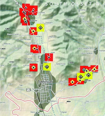
Daily monitoring of active fire locations revealed a pattern of suspected arson starting on 10 August immediately north of Tskhinvali and rapidly expanding in number and extent on 12 August, reaching as far as the ethnic Georgian villages of Kekhvi to the north and Eredvi to the east. As the fires continued on the following days, it was possible to identify from the cumulative distribution of detected fire locations that two distinct clusters of suspected arson attacks were forming, the first centred on ethnic Georgian villages located along the main road (Route P-2) and the Liakhi River north of Tskhinvali, and the second cluster located along a secondary road east of Tskhinvali between the villages of Pirsi and Eredvi (see figure 3).
Map of suspected arson attacks in South Ossetia (Image © UNITAR/UNOSAT).

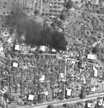
Analysis of very high resolution satellite data acquired on 19 August 2008 provided further evidence of the arson campaign with the dramatic capture in the imagery of at least eight active building fires. As illustrated in Figure 4, a residential building located in the village of Kurta was clearly on fire with an associated plume of dark smoke. Also visible within the satellite imagery were hundreds of small, residential buildings with distinct arson-related damage signatures, such as the lack of building rooftops but with intact load bearing walls, consistent with the stone wall/wood roof construction typical of the region.
Residential building on fire after arson attacks in village of Kurta, South Ossetia (Image © DigitalGlobe).

A rapid damage assessment of the affected villages in the region was conducted using the satellite imagery from 19 August. Results of the assessment were publicly released in the form of maps, with figures on the number of destroyed and severely damaged buildings aggregated by affected village. For the initial results covering the first cluster of building damages, including the city of Tskhinvali northward to the village of Kekhvi, a total of 1,050 buildings were either destroyed or severely damaged. For the second damage cluster located east of Tskhinvali between the villages of Pirsi and Eredvi, a further 300 buildings were either destroyed or severely damaged.Footnote 27
For the majority of these identified building damages, specifically those damages located outside of the main urban extent of Tskhinvali, it was generally possible to attribute the damage to a specific military force, with a limited risk of conflating these damages with those resulting from different military forces. The arson-related building damages concentrated to the north and east of Tskhinvali were confidently attributed to South Ossetian militias engaged in a widespread campaign to cleanse the region of ethnic Georgian residents.
Considering the scale and prolonged nature of the arson attacks over the course of a ten-day period, there was at least a prima facie case that the Russians, as the occupying power of South OssetiaFootnote 28 at the time, had systematically failed to restrain the militias from attacks against civilians and residential property, and were therefore responsible for serious violations of multiple Articles in the Fourth Geneva Convention.Footnote 29
Because of the recognized complexity of the ground-fighting between Georgian and Russian/South Ossetian forces in Tskhinvali between 7 and 12 August, it was apparent that a satellite-based damage assessment within the city posed significant technical and political challenges in terms of both accuracy and potential force attribution. The preliminary assessment for the city was based on the imagery acquired on 19 August 2008, and identified a total of 230 affected buildings. Of this total, 175 buildings were completely destroyed and a further fifty-five severely damaged.Footnote 30 The damages were distributed in a roughly uniform pattern across the city, with multiple small pockets of near total destruction, the worst being the old Jewish quarter of the city with more than twenty-five destroyed buildings in close proximity.Footnote 31
While review of the damage signatures identified in the imagery strongly suggested that most were probably the result of artillery fire, the distinct clusters of building destruction were more consistent with damage patterns typically resulting from a barrage of Grad rockets.Footnote 32 Despite the competing denials of responsibility for the reported residential building damages, imagery assessment suggested that a prima facie case existed against Georgian forces for the indiscriminate use of heavy artillery, and specifically Grad rockets, against densely populated areas of the city during their offensive to capture Tskhinvali on the morning of 8 August 2008.
Based on the findings of post-conflict field validations in Lebanon in 2006,Footnote 33 which showed increasing errors of omission for less severe forms of building damages, it was assumed at the time of the initial assessment that building damages were likely to have been underestimated within the urban environment of Tskhinvali. However, what was poorly understood during the assessment of Tskhinvali was the potential magnitude of the underestimation of severe building damages resulting from tank and artillery shells fired at close range into the sides of buildings.
In September 2008 a Russian NGO, Charta Caucasica, based in the republic of North Ossetia later posted a critical review of the UN satellite-based damage assessment for Tskhinvali. Based on a basic ground survey of the city, the NGO graphically documented the location and type of damages that the UN assessment had failed to identify. Although their critical ground survey was neither rigorous nor did it attempt to provide statistical estimates for errors of omission and commission, the observations in it nevertheless strongly suggested that overall building damages in the city had been seriously underestimated because of the generalized failure to identify from the available imagery the artillery and rocket fire into the sides of mostly residential high-rise buildings.Footnote 34
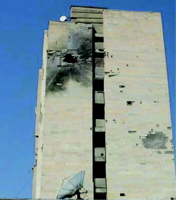
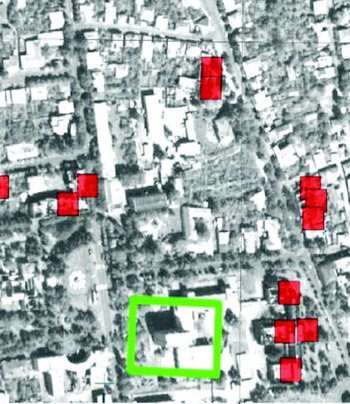
Ground photos of buildings with clearly defined side-impact craters and blast marks were presented with annotated clips of the relevant building as marked in the UN satellite image maps. Figures 5 and 6 show the exact location of unidentified damaged buildings as located in the imagery and the associated photos of the same location taken from the ground. The general conclusion of Charta Caucasica was that satellite imagery was poorly suited for accurate assessment of the full range of damage within the city because of the limited view angle and spatial resolution of the sensor used.Footnote 35 These important limitations should have been better understood and anticipated, and that more explicit disclaimers and qualifications should have been included in the maps produced.
Ground photo of damaged building with side impact crater, Tskhinvali (September 2008), (photograph courtesy of NGO Caucasica).

Satellite map of building shown in Figure 5 (marked in green) surrounded by building damages identified from the imagery (marked in red) (UNITAR/UNOSAT) (Image © DigitalGlobe).

Sri Lanka (2009)
Satellite analysis work conducted by the UN during the Sri Lankan civil war was initiated following a direct request in January 2009 from the UN Country Team in Colombo to provide population estimates of internally displaced Tamil civilians trapped within the government declared No Fire Zones (NFZ-1, -2 or -3) in Mullaittivu district.Footnote 36 Satellite imagery was also collected and analysed during the final five months of the conflict to provide monitoring of large-scale civilian movements, to assess reported shelling incidents within the NFZs, and to identify building damages and impact craters from artillery fire and air strikes. Because of the political sensitivity of the negotiations between the UN Country Team and Sri Lankan authorities over humanitarian access to the conflict zone, satellite-derived reports were not released publicly. However, the Sri Lankan government was duly informed of both their production at the time and the general findings of the analysis during the course of negotiations.Footnote 37
A second phase of analysis was conducted in direct support of the UN Secretary General's Panel of Experts on Sri Lanka in 2010 (the Panel).Footnote 38 Using an approach similar to that used by the Goldstone Mission on Gaza, the Panel drew upon the analysis of satellite imagery for corroboration of individual testimonies related to the shelling of protected sites. The Panel also looked to the imagery analysis to provide, when possible, primary analysis on force attribution for the shelling of areas within the NFZs that were populated with thousands of civilians at the time.
Additional analytical work was conducted on air strike locations and targeting by the Sri Lankan air force, as well as the projected fire bearings of Sri Lankan army mortar and heavy artillery batteries in relation to documented zones of indiscriminate shelling. The analysis findings were presented to the Panel in the form of multiple briefings as well as a finished report,Footnote 39 which was partially incorporated into the Panel's final report to the Secretary General, released in March 2011.Footnote 40
The Panel was primarily interested in detailed damage assessments for a list of protected medical and humanitarian facilities within the conflict zone, both to confirm the dates of reported artillery shelling, and to determine attribution for the attacks if possible. Of the ten specific medical, humanitarian, and religious facilities examined for the Panel,Footnote 41 each showed clear indications of severe building damages probably resulting from indirect artillery fire. Further, the seven medical facilities and the UN humanitarian aid centre were apparently subject to artillery fire while they were reportedly still operational and occupied by civilians seeking humanitarian assistance.
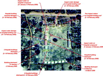
Damage identified within the satellite imagery ranged from small impact craters on building roofs and open courtyards, to instances of total building collapse. All the sites reviewed were either clearly marked as protected humanitarian sites with rooftop medical insignia visible from the air,Footnote 42 or easily distinguished as protected cultural sites by the distinctive building architecture. As shown in Figure 7, the assessment provided to the Panel of the damage to the Vallipunam hospital located on the southern edge of the first NFZ-1 clearly indicated the compound had been heavily damaged by artillery shelling and on multiple dates.Footnote 43
Satellite-based damage assessment for Vallipunam hospital, Sri Lanka (UNITAR/UNOSAT).

With respect to the question of attribution, although there was little doubt that the protected sites reviewed had been damaged by repeated artillery shelling, there was in fact no signature evidence that would have enabled determination of responsibility for the damage, let alone to address the allegations of deliberate targeting. Such damage signatures left by small- and medium-calibre mortar fire could have conceivably come from either the Tamil Tigers (LTTE) or the Sri Lankan army. This is not to suggest that it was impossible to use the imagery available to attribute damage, only that it was not possible based on the site-specific eyewitness testimonies provided to the Panel.
However, once the scale of assessment was expanded to cover larger areas that encompassed the protected sites it became possible to draw reasoned conclusions about which military force was likely responsible for the attack. Detailed assessments for areas within the NFZ-1 and the NFZ-2, and the centre of Puthukkudiyiruppu (PTK) identified a total of 1,525 specific damage sites.Footnote 44 Of this total, over 200 permanent buildings were either destroyed or severely damaged, with an additional 230 separate impact craters identified on permanent building rooftops, and a further 1,020 impact craters identified on open spaces (i.e. fields, beaches, etc.).
Based on analysis of these larger shelling zones, it was concluded that damages to the specific protected sites were, in fact, not the result of isolated or misdirected artillery fire, but part of much larger shelling events, best characterized as area bombardment. Considering the volume of munitions deployed over such large areas and the depleted state of LTTE forces, there was little doubt that only the Sri Lankan army was capable of such heavy and sustained artillery fire. Detailed maps and quantitative figures on these shelling zones were presented to the Panel for consideration as compelling cases of indiscriminate and disproportionate military force by the Sri Lankan army in areas densely populated with tens of thousands of displaced Tamil civilians.Footnote 45
A detailed review of probable air-strike-related damages during a five-month period identified over 130 separate locations directly attributable to the Sri Lanka Air Force (SLAF).Footnote 46 A significant majority of these air strikes were directed against locations with indications of recent LTTE activity,Footnote 47 outside designated NFZs, and removed from concentrations of civilian tents. There were, nevertheless, over ten specific air strike impact craters identified immediately adjacent to civilian tent concentrations and a functioning hospital. One particular air strike location identified inside the NFZ-2 was documented at the time in an internal UN report completed on 2 April 2009,Footnote 48 and represented the first independent evidence of government air strikes within the NFZ-2 contrary to an explicit prohibition against, and denial of, such attacks by the Sri Lankan government.Footnote 49 This report was obtained by a journalist in Colombo who broadcast a story, discussing the main findings of the report, for Channel 4 ITN (UK) on 21 April 2009. The fact that Sri Lankan authorities did not issue any comment following the broadcast was interpreted at the time as a tacit validation of the report conclusions.Footnote 50
An important contribution to the Panel's investigation was a detailed analysis of Sri Lankan artillery batteries located throughout the conflict zone. By monitoring the positioning and orientation of the howitzers and mortar pits over time, it was possible to observe that the Sri Lankan army repeatedly rotated the fire bearing of their artillery towards the NFZ-2 and later the NFZ-3, tracking the movements of civilians and LTTE forces alike as they were forced into the southern sections of a barrier island in late April and early May 2009. These findings were presented to the Panel as compelling evidence that the Sri Lanka Army had, throughout the last months of the conflict, established, maintained, and updated an operational military capability to direct substantial quantities of artillery fire into these NFZs that were heavily populated with civilians at the time.Footnote 51
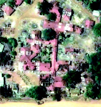
As illustrated in Figure 8, there were also documented cases in which the Sri Lanka Army erected artillery batteries on the grounds of a primary school and the main PTK hospital.Footnote 52
PTK hospital (partially destroyed) with Sri Lankan army mortar battery visible on hospital grounds in lower left (17 June 2009) (Image © GeoEye).

In contrast to Gaza, where no meaningful evidence was produced on potential violations of IHL committed by Hamas during the conflict, there was a significant, if incomplete, body of compelling evidence against the Tamil Tigers during the final stages of the civil war. Not only was it possible to identify cases where the LTTE had tactically deployed artillery next to civilians, apparently using them as human shields – a war crime – it was also possible to document the LTTE's repeated construction of military fortifications (mostly earthen berms and trenches) adjacent to medical facilities, religious sites, and other shelters filled with civilians in violation of international law by putting civilians at unnecessary risk of military attacks by the Sri Lankan armed forces.
The most compelling and comprehensive evidence compiled against the LTTE involved their deliberate positioning of hundreds of heavy vehicles suspected of containing military equipment within areas densely populated by civilians, effectively using them as a human shield against potential attack, as well as exposing civilians to the potential ignition of the vehicle contents. At the end of the conflict, LTTE heavy vehicles were involved in a massive explosive event on the morning of 16 May 2009, producing a zone of total incineration measuring approximately 36,000 m2 in area and destroying an estimated 200 tent shelters. Because of uncertainty about the estimated civilian population remaining within the NFZ-3 at the time, it was not possible to estimate the potential civilian deaths or injuries resulting from the explosion.Footnote 53
Satellites to the rescue?
As shown through the three case studies of Gaza, Georgia, and Sri Lanka, analysis of satellite imagery can often provide independent and compelling evidence in direct support of war crimes investigations. There are, however, a range of technical limits, analytical challenges, and political restrictions to the application of imagery for IHL which must be better understood in order to properly manage expectations of this exciting field of applied humanitarian research.
Technological limits
The obvious limitation of electro-optical satellite sensors is that they simply cannot see through clouds, dense tree-cover, or at night, thereby geographically and seasonally limiting their ability to assess or monitor armed conflicts in many regions of the world. Had the final months of the Sri Lanka civil war occurred, for example, during the eastern monsoon season in late 2008 rather than during the dry season in early 2009, sustained cloud cover would have prevented the use of electro-optical sensors to provide detailed analysis of the conflict.
An increasingly viable alternative source of satellite data in such circumstances is the new generation of radar sensors (known as synthetic aperture radar or SAR sensors) that do not have the same weather-based limitations as standard electro-optical sensors. Because SAR sensors actively map or illuminate the ground using radar, the derived data can be easily acquired at night, through heavy clouds, and even, under certain circumstances, through dense vegetation. Relevant investigative applications could include, for exaample, identifying areas of significant building damages and conflict-related environmental impacts and locating large concentrations of displaced civilians both on land and sea,Footnote 54 as well as the monitoring of conventional military forces.Footnote 55 Despite these important advantages in capability, the practical application of SAR data for research by civilian institutions and NGOs on potential violations of IHL has been limited by several important factors. Traditional image interpretation and processing methods commonly used with electro-optical imagery are not easily transferred to analytical work with SAR data because of the complexity of radar signatures. Analysts possessing such specialized skills are still heavily concentrated within national military and intelligence agencies and thus less available for equivalent civilian research. Because of the often dual-use legal agreement underpinning the operation of very high resolution SAR sensors, there are not only significantly higher data costs, but the data is also potentially subject to political restrictions over sensitive areas.Footnote 56
One poorly understood but frequently encountered limitation is that very high resolution (VHR) satellites (including both electro-optical and SAR sensors) do not collect imagery automatically and continuously over the world, but rather are tasked over specific areas with known commercial, political, or humanitarian value. This can mean that unreported and unanticipated conflicts in remote areas can easily go undocumented by commercial sensors for weeks or months at a time, leaving little or no relevant evidence of the conflict detectable in the available imagery once it is eventually acquired. There were, in fact, multiple instances encountered by the UN over the last five years in which requests for satellite-based analysis of particular incidents were simply never conducted for lack of relevant imagery coverage.Footnote 57
Asymmetrical conflicts involving irregular forces, as in Gaza and Sri Lanka, will continue to present serious technical and analytical challenges. Because of limits to the resolution of civilian satellite sensors, it will remain exceedingly difficult to identify the movement or actions of irregular or poorly-armed insurgent groups, groups which do not possess or are not in a position to deploy conventional military forces and materials readily identified from space. Small-unit guerrilla forces fighting within urban environments or under camouflage or dense vegetation canopy will remain largely invisible, posing a general problem of unbalanced focus on the actions of conventional armed forces.Footnote 58
Satellite imagery analysis will continue to be limited in its ability to identify the use of prohibited weapons systems. In Georgia, for example, no meaningful evidence on the use of cluster munitions by Russian forces in and around the city of Gori was collected from imagery despite detailed field reports from Human Rights Watch providing the approximate timing and locations of the reported attacks.Footnote 59 Basic questions regarding the use of white phosphorus artillery shells in Gaza by the IDF could not be answered for lack of signatures in the imagery, and thus no insights on the potential legality of their use were possible.
One of the most serious limitations to conducting satellite-based damage assessments remains a chronic inability to detect damages caused by ground fire from tanks, rocket-propelled grenades and low-trajectory artillery. In the case of Tskhinvali, this resulted in an undercount of potentially hundreds of affected building sites across the city, leading to the risk of a perception of political bias against South Ossetian forces simply because the arson-related damages they inflicted were more easily and accurately documented. It would be safe to conclude that the damage assessment maps released by the UN at the time contained uneven levels of accuracy, with errors of omission spatially concentrated in exactly those parts of the city that had been most affected by Georgian government shelling during their offensive in early August 2008. Unfortunately, it is unlikely that this specific limitation will be adequately addressed in the near future despite anticipated improvements in sensor technology.
Analytical challenges: ambiguous, inconclusive, and uncertain findings
It is important to understand that detailed imagery analysis can often result in ambiguous, inconclusive, and even politically contested or erroneous findings. An example is the largely discredited interpretations of satellite imagery presented by US Secretary of State Powell at the UN Security Council over alleged chemical and biological weapon facilities in Iraq during the build-up to the Second Gulf War.Footnote 60 Analysts can make mistakes, come to widely divergent conclusions about the same image, and can even subconsciously shape their findings to meet preconceived user or organisational expectations. More common are a broader range of circumstances when complex events occur on the ground and present distinct challenges for the production of relevant and meaningful satellite-derived information on armed conflict.
One of the primary challenges encountered during the Sri Lankan civil war was the difficulty confirming reports of mortar shelling within the NFZs – clearly an issue of acute relevance to the Panel of Experts' investigation. Survival tactics such as the construction of family wells, latrines, and bomb shelters, as well as the high portability of tents and the associated debris left behind, had the cumulative effect of substantially masking the impact signatures of small- and medium-calibre mortar shells. It was therefore likely that evidence of artillery shelling was differentially masked in areas, depending on the relative number of civilian tent shelters, effectively leaving areas of highest population density with the lowest levels of shelling evidence.
Uncertainties in image interpretation are commonly encountered in complex or unfamiliar environments when the temporal coverage of available imagery is insufficient to capture and reconstruct a series of specific events on the ground. Multiple interpretations, each of which is potentially equally probable, may result in such circumstances, leaving questions of direct humanitarian interest unanswered. Typically ambiguous cause-and-effect scenarios result from the binary comparison of two satellite images recorded over a given area, one recorded before an event and the other after. The objective in this context is to try to determine exactly what occurred on the ground between these two static snapshots in time. When analysis is dependent on a very limited time series of imagery, especially when the ‘pre-imagery’ is recorded months or sometimes even years before, it is probable that multiple complex events will effectively be compressed into one static and highly ambiguous overview which is of little value.
A basic question asked of satellite imagery after reports of rebel forces advancing on a refugee camp, for example, is has the camp been attacked or not? Although the post-event image may indeed show the absence of tent shelters, it may not necessarily contain enough details to determine with sufficient confidence whether rebel forces demolished the shelters during an attack, or if the shelters were hurriedly packed by fleeing residents in advance of a feared attack. In such complex and poorly documented circumstances, the relative lack of sufficient satellite imagery will usually result in ambiguous and inconclusive findings.Footnote 61
As is apparent in all three of the case studies, determining likely force attribution for any given attack based on a narrow inspection of damage signatures contained in available imagery is often exceedingly difficult and potentially misleading. For example, small impact craters identified on hospital rooftops or in open fields in Sri Lanka could, if taken in isolation from the wider context, conceivably have been inflicted by either side in the conflict. Even large-scale events, such as the massive explosion during the final hours of the Sri Lankan civil war, may present ambiguous or marginal clues within the imagery insufficient to suggest which side was likely responsible.
Political restrictions and the future
Since the US government decision in 1994 to authorize the commercialization of essentially military technology, public access to very high resolution satellite imagery and the proliferation of new and improved sensors has generally proceeded without significant political interference or restrictions.Footnote 62 There remains, however, a notable exception that continues to adversely impact the use of imagery over important conflict areas in the Middle East. In 1997 the US government enacted a law prohibiting the sale or distribution of satellite imagery with under two metre spatial resolution over Israel, Gaza, the West Bank, the Golan Heights, as well as within a five-kilometre buffer zone into Egypt, Syria, and Lebanon.Footnote 63
This restriction was directly felt during the Gaza conflict in 2009, in that it forced commercial satellite providers to systematically degrade imagery recorded over the Gaza Strip to only 25 per cent of the original resolution. In fact, all of the UN monitoring and analysis work on Gaza for the humanitarian community, and specifically for the Goldstone Mission, was based on degraded-quality imagery that had a significantly negative impact on overall accuracy and confidence levels. Although no attempts have been made to quantify the impact, it almost certainly caused a systematic underestimation of virtually all forms of building and infrastructure damage across the Gaza Strip.
Although legally this restriction applies only to US satellite sensors, both the US and Israeli governments have, until recently, successfully secured bilateral agreements with European and Asian satellite companies to adopt similar restrictions.Footnote 64 One apparent consequence of recent diplomatic tensions between Turkey and Israel is that the planned Turkish satellites GökTürk-1 and GökTürk-2 may start by 2013 to acquire and distribute sub-metre resolution imagery over the whole of Israel and the Palestinian territories.Footnote 65 If this occurs, it could conceivable lead to the eventual revision or outright repeal of the US restriction.
One of the potential political consequences of the use of satellite technology for conflict monitoring and analysis is a growing interest of many UN member states within the Group of 77 to restrict the production and public release of satellite-based research on pressing issues of human rights and IHL. Programmes within the UN system have, in fact, come under pressure from recent agency guidelines that are increasingly restricting the public dissemination of satellite-derived information on armed conflicts and major humanitarian emergencies.Footnote 66
It remains uncertain if these political attempts within the UN system to restrict the use of satellite technology will have a long-term negative impact on the ability of the UN to support future investigations. What is certain, however, is that in the near future the broader humanitarian and human rights community will increasingly adopt the necessary technical and analytical skills in order to conduct their own independent satellite-based conflict monitoring and analysis.