Fort Rock Cave holds an iconic position in the archaeological history of the northern Great Basin and in the debate surrounding when people first colonized the Desert West. Artifacts recovered during the site's initial excavation demonstrated that humans first occupied the Great Basin during the early Holocene (Arnold and Libby Reference Arnold and Libby1951; Cressman Reference Cressman1951), and later work raised the possibility that people first visited Fort Rock Cave as early as ~15,000 cal B.P. (Bedwell Reference Bedwell1970, Reference Bedwell1973), two millennia before the Clovis era (Waters and Stafford Reference Waters and Stafford2007). That claim remains unconfirmed due to poor reporting standards and an undemonstrated association between artifacts and dated charcoal. As such, most archaeologists dismiss the site in the pre-Clovis debate (Beck and Jones Reference Beck and Jones1997; Fiedel Reference Fiedel2000; Haynes Reference Haynes, Taylor, Long and Kra1992; Hockett et al. Reference Hockett, Goebel, Graf, Fowler and Fowler2008). Recent work at the nearby Paisley Five Mile Point Caves demonstrates that people occupied the northern Great Basin by at least ~14,500 cal B.P. (Gilbert et al. Reference Gilbert, Jenkins, Götherstrom, Naveran, Sanchez, Hofreiter, Thompson, Binladen, Higham, Yohe, Parr, Cummings and Willerslev2008; Jenkins et al. Reference Jenkins, Davis, Stafford, Campos, Hockett, Jones, Cummings, Yost, Connolly, Yohe, Gibbons, Raghavan, Rasmussen, Paijmans, Hofreiter, Kemp, Barta, Monroe, Thomas, Gilbert and Willerslev2012, Reference Jenkins, Davis, Stafford, Campos, Connolly, Cummings, Hofreiter, Hockett, McDonough, Luthe, O'Grady, Reinhard, Swisher, White, Yates, Yohe, Yost, Willerslev, Graf, Ketron and Waters2013), suggesting that although Bedwell's (Reference Bedwell1973) claim of a roughly contemporary occupation at Fort Rock Cave remains undemonstrated, it should not necessarily be dismissed outright. Work at the Paisley Caves has also highlighted the utility of returning to old sites in search of new data. In this paper, we focus on both issues: (1) evaluating the claim for pre-Clovis occupation of Fort Rock Cave, and its remaining potential for contributing to ongoing debates about how and when the New World was colonized; and (2) the prospects and problems that previously excavated sites offer to researchers seeking new answers to old questions.
History of Work at Fort Rock Cave
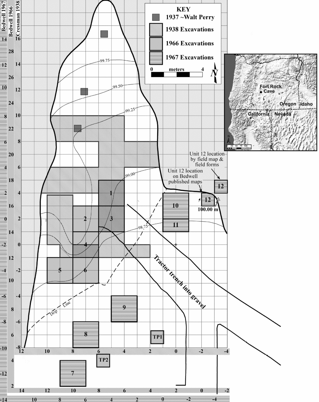
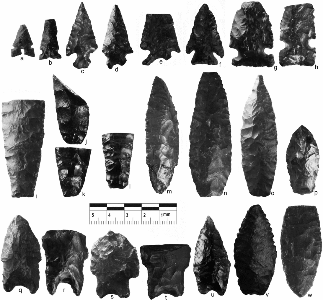
In 1937, amateur archaeologist Walt Perry excavated three small test pits in Fort Rock Cave. In a letter to University of Oregon archaeologist Luther Cressman, he reported finding “cracked and calcined bones and obsidian flakes” (Perry Reference Perry1937:2). In 1938, Cressman led a crew from the university to work at Catlow, Paisley, and Fort Rock caves. At Fort Rock Cave, the crew excavated ~55 m2 in just nine days, but recovered artifacts later recognized as Western Stemmed Tradition (WST) points and dozens of sagebrush bark sandals below what we now know as Mt. Mazama ash (Figures 1–3).
Plan view of Fort Rock Cave showing the different grid systems and locations of excavations during the 1938, 1966, and 1967 field seasons.

A selection of Fort Rock Cave twined sandals of pre-Mazama age, made of sagebrush bark (Brian Lanker photo, courtesy the University of Oregon Museum of Natural & Cultural History).

A selection of (a–h) post-Mazama and (i–w) pre-Mazama artifacts from Cressman's 1938 excavation, UOMNCH Accession 60: (a–b) Desert Side-notched; (c) Rosegate; (d–e) Elko Eared; (f) Elko Corner-notched; (g–h) Northern Side-notched; (i–w) Western Stemmed Tradition (including Parman, Haskett, and Windust subtypes) and Cascade/Foliate points.

At the time of the discovery, the origin and age of the tephra was unknown, but Cressman claimed that artifacts found below it possessed great antiquity, a claim dismissed by many of his contemporaries (e.g., Krieger Reference Krieger, Cressman, Baker, Conger, Hanson and Heizer1944; Roberts Reference Roberts1940; Steward Reference Steward1940). Steward (Reference Steward1940) asserted that basketry from the Oregon caves demonstrated contemporaneity with the Basketmaker Culture (ca. 1500–3500 cal B.P.) in the American Southwest, while Roberts (Reference Roberts1940) argued that the volcanic ash was deposited within only the last 1,000 years. Martin and colleagues (Reference Martin, Quimby and Collier1947:228) proclaimed in their overview of North American archaeology, Indians before Columbus, that the southeastern Oregon culture “is probably not more than two thousand years old.” With the advent of radiocarbon dating in 1950, Cressman submitted sandals from Fort Rock Cave to the University of Chicago for dating. When averaged, two radiocarbon dates produced an age of 9053 ± 350 B.P. (9436–11,211 cal B.P.).Footnote 1 As a result, Arnold and Libby (Reference Arnold and Libby1951:117) declared the Fort Rock sandals to be the “oldest artifacts measured in the Americas,” and vindicated Cressman's claim for an early occupation of the region. Today, the Fort Rock sandals remain the earliest directly dated footwear in the world, and Fort Rock–style sandals have been directly dated to the terminal Pleistocene/early Holocene (TP/EH) at nine other northwestern Great Basin sites (Connolly et al. Reference Connolly, Barker, Fowler, Hattori, Jenkins and Cannon2016; Ollivier Reference Ollivier2016). Because of the early age of the well-crafted footwear and the site's role in the debate surrounding the colonization of the far west, Fort Rock Cave was designated a National Historic Landmark in 1961 and listed on the National Register of Historic Places in 1966.
In 1966 and 1967, Cressman's student Stephen Bedwell returned to Fort Rock Cave to secure additional datable material (Bedwell and Cressman Reference Bedwell, Cressman and Aikens1971; Cressman Reference Cressman1988). In the three decades following Cressman's excavations, the site witnessed rampant looting, and by the time of Bedwell's return, the cave's interior was largely cleaned out. A rancher had mechanically removed some deposits to provide better shelter for livestock; after manure in the cave caught fire and burned for an extended period, he extinguished the fire by flooding the cave and removing the manure with a tractor (Kittleman Reference Kittleman and Cressman1968). Today, staining on the cave walls well above the current floor marks the original position of the top of the cave's deposits (Figure 4).
Interior of Fort Rock Cave today. The line on the wall indicates the approximate floor height when Cressman initially excavated in the cave in 1938.

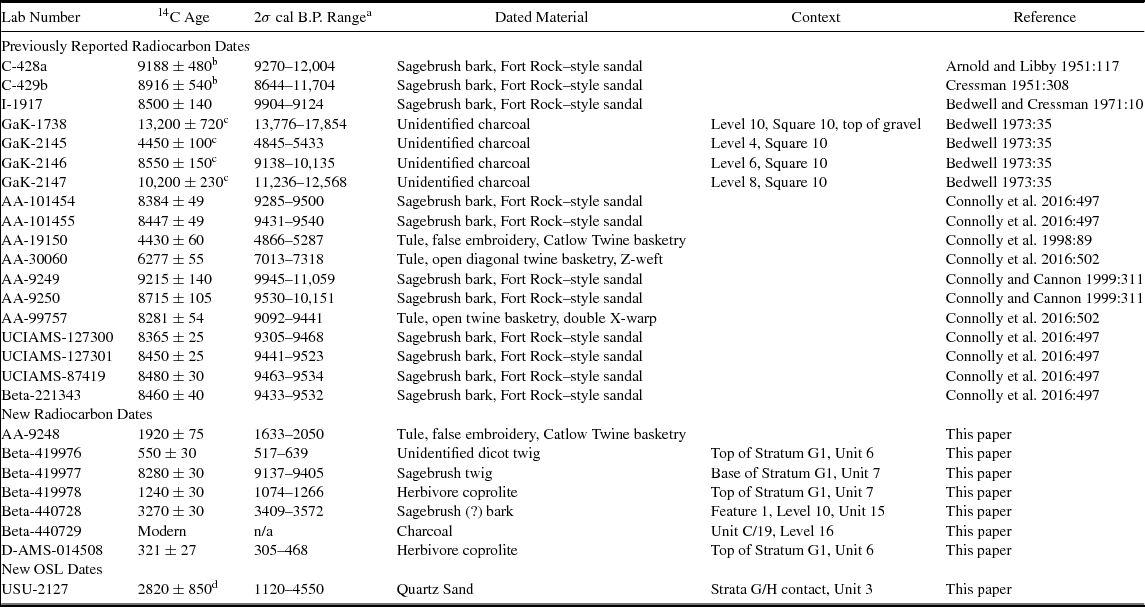
When Bedwell returned in 1966, he focused most of his efforts inside the cave, where he failed to identify intact deposits (and, in fact, did not bother to catalog artifacts from the interior units that he thought were stratigraphically unreliable). The following year, he located undisturbed deposits just outside the cave's mouth, where he radiocarbon-dated four charcoal samples from a stratigraphic column in Square 10 (Table 1; see Figure 1). The dates were in proper stratigraphic order, and the deepest sample, purportedly collected from atop Pleistocene lake gravels, possesses a calibrated midpoint of more than 15,000 cal B.P. Bedwell (Reference Bedwell1973) claimed that artifacts, including a mano, several scrapers, and a WST projectile point, were closely associated with the radiocarbon sample.
Radiocarbon and OSL Dates from Fort Rock Cave.

a All radiocarbon dates calibrated using OxCal 4.2 online program (Bronk Ramsey Reference Bronk Ramsey2009) with IntCal13 curve (Reimer et al. Reference Reimer, Bard, Bayliss, Beck, Blackwell, Ramsey, Buck, Cheng, Edwards, Friedrich, Grootes, Guilderson, Haflidason, Hajdas, Hatté, Heaton, Hoffmann, Hogg, Hughen, Kaiser, Kromer, Manning, Niu, Reimer, Richards, Scott, Southon, Staff, Turney and van der Plicht2013).
b When averaged together, these two dates produce the 9053 ± 350 14C B.P. age commonly cited for the “Fort Rock Sandal.”
c These dates were run by the Gakushian Laboratory. Several researchers have expressed concern about the reliability of GaK dates. The two oldest samples, Gak-1738 and Gak-2147, possess very large standard errors and appear anomalous. The other two samples, Gak-2145 and GaK-2146, returned ages consistent with recent AMS dates from the site.
d OSL date is in calendar ages before A.D. 2015 with 2σ standard error. Age analysis uses the single-aliquot regenerative-dose procedure of Murray and Wintle (Reference Murray and Wintle2000) on 1–2 mm small-aliquots of quartz sand (59 aliquots analyzed, 11 used in age calculation); Dose rate (Gy/ka) = 2.44 ± 0.13; DE ± 2σ (Gy) = 6.88 ± 1.93 (Equivalent dose [DE] calculated using the mean); Overdispersion % = 0.0 (variance in DE data beyond measurement uncertainties).
As they had with Cressman's claims, researchers dismissed Bedwell's early date as too old and questioned the association between the artifacts and the dated charcoal (Beck and Jones Reference Beck and Jones1997; Fiedel Reference Fiedel2000; Haynes Reference Haynes, Taylor, Long and Kra1992; Hockett et al. Reference Hockett, Goebel, Graf, Fowler and Fowler2008). Unfortunately, such questions remain unresolved because neither Cressman nor Bedwell fully reported their work at the site. Field notes, profile drawings, and photographs document their respective efforts, but they are not detailed enough to resolve long-standing questions about when Fort Rock Cave was initially occupied. Only additional fieldwork would hold the potential to do so, and with that goal in mind, we returned to Fort Rock Cave in 2015 and 2016. Our primary objectives were to document the site's remaining stratigraphy, assess the integrity of any remaining deposits, and, if possible, evaluate the context of Bedwell's earliest radiocarbon date. Here we present the results of those efforts.
Materials and Methods
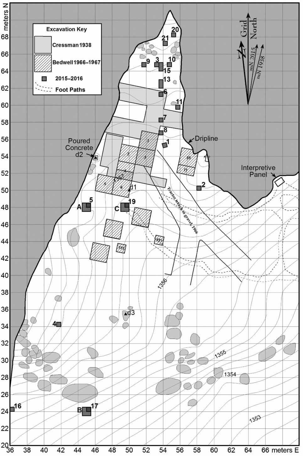
A major obstacle in revisiting sites excavated long ago is reconstructing the original investigation. Cressman's (Reference Cressman1938) and Bedwell's (Reference Bedwell1967–Reference Bedwell1968) notes indicate that the same grid system was at least approximated in 1938, 1966, and 1967, although a different coordinate system was apparently used each year. Unfortunately, we failed to locate any permanent datum marker that would enable us to reestablish their grid. In addition, we found significant discrepancies between field maps and published maps, creating uncertainty regarding the true locations of some excavation units and their relationships to one another. In light of these issues, we imposed yet another provenience grid on the site, set permanent datum markers, and established true elevations using a USGS benchmark located atop the nearby Fort Rock caldera (Figure 5).
Locations of 2015 and 2016 test pits superimposed on a new site map that features absolute elevations inside Fort Rock Cave.

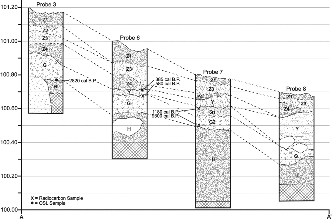
To assess the integrity of the remaining deposits, we excavated 7.25 m2 during two week-long sessions. We excavated 18 probes inside and outside of the cave's dripline; most probes were 0.25 m2, but probes 13 and 15 inside the cave were 0.5 × 1 m in size to provide more continuous stratigraphic exposures, and three outside the cave, where deeper deposits lie above the lake gravels, were expanded to 1 m2 units. We laid out probes 12, 14, and 18 initially, but in light of the extent of disturbance in adjacent units did not excavate them. We excavated in 5 cm levels measured from the current ground surface and started new levels when we noted stratigraphic changes. We sifted all sediment using one-eighth-inch screens and point-plotted diagnostic artifacts (e.g., projectile points) when recovered in situ. Previous researchers noted that the basal beach gravels were sterile. We excavated one unit, Probe 7 (Figure 6), approximately 50 cm into those sediments to verify this claim; doing so, we terminated other units after reaching the beach gravel contact.
Stratigraphic fence diagram of Fort Rock Cave across a north-south cross-section.

Results
Formation Processes
Lake-Level History
Fort Rock Basin is near the northeastern margin of the Basin and Range physiographic province characterized by Tertiary extensional tectonics producing fault-block topography and closed basins that held Quaternary pluvial lakes (Freidel Reference Freidel, Aikens and Jenkins1994; Lawrence Reference Lawrence1976; Walker et al. Reference Walker, Peterson and Greene1967). Late Pliocene and Pleistocene volcanism built numerous volcanic cones and tuff rings, including the prominent landform of Fort Rock itself. Freidel (Reference Freidel, Aikens and Jenkins1994) identified five major Quaternary shorelines in the basin representing at least two major late Pleistocene lake cycles. No radiocarbon ages are available to determine when the lake reached its high stand at 1,384 m. Freidel (Reference Freidel, Aikens and Jenkins1994:31) hypothesized that this shoreline formed either sometime before 42,000 cal B.P. or during the Last Glacial Maximum (LGM), when a high stand at the equivalent elevation in the adjacent Alkali Basin overflowed into the Fort Rock Basin, stabilizing the lake level there at 1,384 m. Alternatively, the LGM flow from Alkali Basin may have stabilized Pluvial Lake Fort Rock at 1,367 m, the next highest shoreline. The most prominent shoreline in Fort Rock Basin is at 1,353–1,356 m, which formed the wave-cut Fort Rock Cave presumably between the LGM and approximately 15,000 cal B.P. It is unknown whether the 1,353–1,356 m shoreline formed as the result of either a single still stand or multiple lake-level changes stabilizing at this elevation (Freidel Reference Freidel, Aikens and Jenkins1994:32). As the terminal Pleistocene approached, Pluvial Lake Fort Rock fell another 18 m, stabilizing again at 1,332 m. Lower shorelines in the basin provide evidence of a persistent lake well into the early and late Holocene (Allison Reference Allison1979; Forbes Reference Forbes1973; Jenkins, Droz, and Connolly Reference Jenkins, Droz, Connolly, Jenkins, Connolly and Aikens2004). Besides formation of the wave-cut notch that is Fort Rock Cave, the 1,353–1,356 m and 1,332 m lake levels are critical sediment sources for the earliest geological and archaeological deposits.
Site Stratigraphy
Cressman (Reference Cressman1942:25) and Cressman and Williams (Reference Cressman, Williams, Cressman, Williams and Krieger1940) did not describe the site stratigraphy in detail, other than declaring that “like the Paisley Caves, [Fort Rock Cave] failed to show convincing stratigraphy.” He simply distinguished “above pumice” (Mazama tephra) and “below pumice” assemblages. Based on Cressman's (Reference Cressman1942:Figure 9) published schematic profile, it appears that the sub-Mazama occupation stratum is up to 45 cm thick near the central area of his excavation, tapering to thin lenses at the margins of his block. When Bedwell returned to reexamine the site in 1966, he failed to identify intact deposits in the cave's interior and focused the following year on areas outside of the cave's mouth. There he found that Cressman's occupation layer was thin and contained no preserved perishable artifacts. Importantly, Bedwell (Reference Bedwell1970:30) correlated this layer with a “cobble-filled brown silt observed below the pumice.”
Both University of Oregon geologist Lawrence R. Kittleman (Reference Kittleman and Cressman1968) and Bedwell (Reference Bedwell1973) provide descriptions of the site's stratigraphy. Kittleman (Reference Kittleman and Cressman1968:2) divided the deposit into five depositional units including angular “talus and roof fall material” (Stratum I), two strata of lacustrine gravel (II and III), a “thin and discontinuous” silty sand (IV) that correlates with Cressman's (Reference Cressman1942) occupation layer, and a post-Mazama sandy pumice (V) that also contained artifacts. Bedwell's (Reference Bedwell1970:28) Square 10 profile, which he presented as “the typical stratigraphic picture” describes eight distinct strata labeled A through H in his field drawing. Strata A through F include various ash lenses, manure accumulations, surface dust, and pumiceous strata subsumed within Kittleman's Stratum V. Bedwell's Strata G and H correspond to Kittleman's strata III and II; his Square 10 profile did not recognize the discontinuous silty sand recorded by Kittleman (i.e., his Stratum IV) between the pumiceous sand and the Pleistocene gravels.
The primary objective of our project geoarchaeology was to systematically describe the remaining deposits and determine whether intact deposits remained to evaluate the likelihood of the pre-Clovis occupation. To maintain consistency with the original work, we followed Bedwell's (Reference Bedwell1970) stratigraphic descriptions (i.e., Latin letters A through H) to the extent possible. Given uncertainties in the location of both Cressman's and Bedwell's excavations and the subsequent vandalism and other activities, the primary challenge was differentiating in situ deposits from backfill. We determined that the bulk of the extant deposits are in fact backfill, which we designated strata Y and Z to be consistent with the Latin letter designations but to avoid overlap with Bedwell's system (see Figure 6). Backfill consisted of unburned and burned cow manure (Stratum Z) and loose gravelly silt with a dominant component of sand- and granule-size pumice (Stratum Y) that is a mixture of pre- and post-Mazama sediments composed of well-rounded beach gravels, eolian silt, and Mazama pumice.
Our test excavations demonstrate that no deposits resembling Bedwell's strata A through F remain intact within the cave interior. The bulk of the remaining deposits consist of two distinct strata that we are confident correlate with Bedwell's strata G and H. Stratum G is silty gravel with clasts up to 10 cm in maximum diameter in a clast-supported framework. Stratum H is gravel with clasts reaching 25 cm in maximum diameter in an imbricated, clast-supported framework. Stratum H contains red and gray basalt clasts that both Bedwell (Reference Bedwell1970) and Kittleman (Reference Kittleman and Cressman1968) described. The key properties differentiating strata G and H are the notably redder vesicular gravel in Stratum H, and the fact that dark, yellowish-brown silt infiltrated voids between clasts in Stratum G while basalt coarse sand and granules filled voids in Stratum H. We interpret Stratum H as a beach shingle of pluvial Lake Fort Rock deposited during the 1,353–1,356 m stand still. Two working hypotheses explain deposition of Stratum G. First, Stratum G may be facies of the terminal Pleistocene beach gravel deposited during the same event as Stratum H but with a dominant postdepositional eolian component that originated from the nearby shoreline as the lake retreated to the 1,332 m elevation. Alternatively, and more likely, because of clast-size differences and the fact that Stratum G lacks the diagnostic red vesicular gravels of Stratum H, Stratum G gravels may reflect a separate still stand from the one depositing Stratum H gravels. This explanation would be consistent with Freidel's (Reference Freidel, Aikens and Jenkins1994:32) hypothesis of multiple stand stills of Pluvial Lake Fort Rock at the 1,353–1,356 m elevation. Stratum G both inside and outside the shelter yielded a large volume of chipped stone debitage and highly processed animal bone (see below). The eolian silt and artifact assemblage were deposited after the gravel with both filtering into an open framework of the clast-supported gravel matrix.
Site Chronology
Site radiocarbon chronology prior to our work was based on seven dates from Cressman's (Reference Cressman1951), Bedwell's (Reference Bedwell1970, Reference Bedwell1973) and Bedwell and Cressman's (Reference Bedwell, Cressman and Aikens1971) work, and 12 direct AMS ages on sandals and basketry (Connolly et al. Reference Connolly, Barker, Fowler, Hattori, Jenkins and Cannon2016; Table 1). We first reconsider the context of the controversial early dates Bedwell reported, all of which are from his Square 10 located just outside the cave's mouth. The ages are in apparent proper stratigraphic order (Level 4, ca. 5150 cal B.P.; Level 6, ca. 9650 cal B.P.; Level 8, ca. 11,900 cal B.P.), including the deepest one from the top of Pleistocene lake gravels (i.e., Stratum G) in Level 10, which calibrates to ca. 15,800 cal B.P.
We learned from field notes of crew members Stanley Bussey and Charles Rohrbaugh that both levels 4 and 6 were clearly within the pumiceous sand (likely Bedwell's Stratum D or F; Kittleman's Stratum V) derived from the Mt. Mazama eruption. In Level 6, Bussey (Reference Bussey1967:18) recorded that “fill was the same as upper levels of this stratum—brown or yellowish-tan pumicy dirt.” Clearly, Bedwell's age of ~9650 cal B.P. in a deposit consisting largely of redeposited pumice from the ~7600 cal B.P. Mt. Mazama eruption is erroneous. The excavators may have reached the base of the pumice stratum at the bottom of Level 8; they initially encountered an “increasing amount of rock,” but the “amount of pumice is about the same” (Bussey Reference Bussey1967:20). Bussey (Reference Bussey1967:22) states that by the end of the level, “pumice has dropped slightly in amount.” Again, it is improbable that a date of nearly 12,000 cal B.P. would be associated with the base of the Mazama unit or the immediate sub-Mazama surface. Cultural material and fragments of sagebrush bark increased in Level 9, which seems consistent with Cressman's occupation layer and from where numerous radiocarbon ages on sandals range from ~10,500 to ~9350 cal B.P. (Connolly et al. Reference Connolly, Barker, Fowler, Hattori, Jenkins and Cannon2016). In Level 10, Bussey (Reference Bussey1967:26) noted, “We are now in the silt covered cobble layer. . . . Below the ash (mentioned above) was the first appearance of the pure silt found between the cobbles.” Based on our observations, this is certainly Stratum G. The charcoal sample that produced the oldest age was “taken from ash lense [sic]” in this level (Bussey Reference Bussey1967:26). Bedwell (Reference Bedwell1970:26) reported the sample as being from “a fire area directly on top of the gravel in Square 10.” Cressman (Reference Cressman1977:146) later reported this as a “hearth,” a term not used by either the excavators or Bedwell.
These interpretations as established from the original field notes collectively call into question the contextual reliability of Bedwell's (Reference Bedwell1970) Square 10 chronological sequence. Compounding the problem is the fact that the oldest ages have large errors, and are from the Gakushuin Laboratory, which produced erroneous dates, particularly in the 1960s and early 1970s on the Great Plains (Banks and Wigand Reference Banks and Wigand2005; Blakeslee Reference Blakeslee1994), Oceania (Clark and Anderson Reference Clark and Anderson2001; Spriggs Reference Spriggs and Spriggs1990), and Alaska (Maschner Reference Maschner2004). Given the improbable context of the Fort Rock dates noted here, and problems with Gakushuin Laboratory dates, Bedwell's Square 10 sequence, including the 15,800 cal B.P. date, are likely unreliable.
2015–2016 Chronology. We obtained seven radiocarbon ages and one optically stimulated luminescence (OSL) date from our 2015–2016 fieldwork (see Table 1, Figure 6). Organic samples for radiocarbon analysis come from probes 6, 7, and 15, located near the center of the cave. We noted some disturbance to the top of the gravel in Probe 7, and the integrity of the other gravel deposits was uncertain, but we obtained two samples from the top and bottom of Stratum G in each of probes 6 and 7. The young upper ages confirm disturbance at the top of the stratum in both units. While the young ages at the bottom of Stratum G in probes 3 and 6 indicate a mixed deposit in this portion of the shelter interior, a date from the base of Stratum G in Probe 7 is consistent with the main occupation associated with the sandals. We identified a pocket of charcoal-stained sediment (Feature 1) with some faunal material within Stratum H in Unit 15 adjacent to Probe 3 (see Figure 5). A radiocarbon age of 3490 cal B.P. indicates a late Holocene disturbance into this terminal Pleistocene deposit.
To help establish an independent chronological control directly on the sediment deposition, we collected a single OSL sample from the Stratum G–H contact in Probe 3, which was located near the rear of the cave well north of previous excavations. Fort Rock Cave is not an ideal location for OSL dating due to the relatively young (i.e., Pleistocene) volcanic terrain that lacks suitable quartz or feldspar sands. While we made an effort to date single grains of quartz and small aliquots of feldspar, the final age estimate was based on 11 of 59 accepted small aliquots of quartz sand (Rittenour Reference Rittenour2016; Table 2). The sample returned an age of 2820 ± 850 B.P., which is also clearly too young for the context and, like the mixed radiocarbon ages, indicates substantial disturbance in the rear of the cave.
Optically Stimulated Luminescence (OSL) Date from Fort Rock Cave.

a Age analysis using the single-aliquot regenerative-dose procedure of Murray and Wintle (Reference Murray and Wintle2000) on 1–2 mm small-aliquots of quartz sand. Number of aliquots used in age calculation and number of aliquots analyzed in parentheses.
b Equivalent dose (DE) calculated using the mean.
c Overdispersion (OD) represents variance in DE data beyond measurement uncertainties, OD.
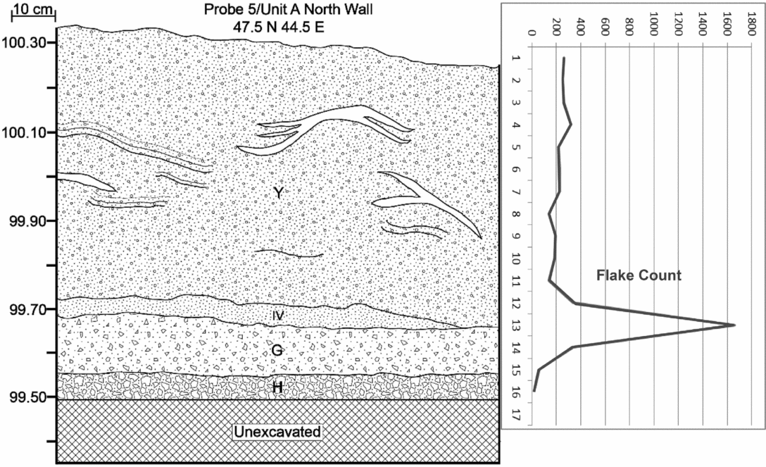
Outside the cave, we excavated the 1 m2 Unit 5 down ~70 cm through very loose pumice sand before encountering a ~5 cm thick lens of pumice-free silt that we believe is pre-Mazama (> 7700 cal B.P.) in age (Figure 7). The lens overlaid and filtered down into underlying gray gravels. We documented a dramatic peak in lithic artifacts in the thin silt lens, which clearly corresponds to the silt lens that Kittleman (Reference Kittleman and Cressman1968) correlated with Cressman's (Reference Cressman1942) occupation layer. Unfortunately, we did not encounter any dateable material in Unit 5. In nearby Unit 19, located in front of the cave about 4 m east of Unit 5, Stratum G was partially disturbed; a charcoal sample taken near the Stratum G/H contact returned a modern age (Beta-440729).
Stratigraphic profile and flake density by 5 cm level for Unit 5, located outside the dripline of Fort Rock Cave. The Stratum IV designation reflects the stratum as described by Kittleman (Reference Kittleman and Cressman1968).

Lithic Artifacts and Faunal Remains
Although the stratigraphic investigations at Fort Rock Cave were disappointing due to extensive disturbance over the years, we recovered a modest sample of lithic artifacts (mostly obsidian) and a huge volume of animal bones from our excavations. A preliminary analysis has identified jackrabbit, marmot, and artiodactyl elements, including some elk-size bones, in the sample (Patrick O'Grady, personal communication 2016). Although well preserved, most bones are highly fragmented and were probably extensively processed. Edge-modified obsidian flakes are the most common tool type recovered during our work, followed by projectile points and point fragments. Most projectile points are foliate or WST types. We also recovered a Northern Side-notched point base and several Rosegate points, indicating that people used the cave at least intermittently throughout the Holocene. Ground stone artifacts include metate fragments, a mano fragment, and anvil or abrading stones. Other notable artifacts include a pipe fragment and a possible bone point. Unfortunately, we recovered most artifacts from clearly disturbed deposits.
Discussion and Conclusion
People occupied Fort Rock Cave extensively during the early Holocene and potentially the terminal Pleistocene, a fact that explains the site's inclusion in reviews of TP/EH archaeology (Beck and Jones Reference Beck and Jones1997; Jenkins, Connolly, and Aikens Reference Jenkins, Connolly, Aikens, Jenkins, Connolly and Aikens2004). While most researchers dismiss Bedwell's (Reference Bedwell1973) claim of an exceptionally early occupation, the fact that the nearby Paisley Caves were first occupied ~14,500 cal B.P. compelled us to revisit the possibility that Fort Rock Cave might also hold clues about early visitors to the region. The primary goal of our return to Fort Rock Cave was to assess the integrity of remaining deposits and, potentially, to evaluate the context of Bedwell's earliest radiocarbon age. Based on a review of Bedwell's and Cressman's field notes, it appears that at least some of the reported ages are too old. In light of this, and the demonstrated unreliability of Gakushuin dates, we discount the earliest radiocarbon dates from Fort Rock Cave.
When we exclude the problematic dates, the reliable dates (e.g., those obtained on basketry) in aggregate reflect several trends in site occupation also suggested by the artifact assemblage:
-
(1) No clearly demonstrated occupation before 11,000 cal B.P.
-
(2) A substantial occupation dating to 10,500–9200 cal B.P. associated with the site's famous sandals and reliable, direct dates on fiber artifacts. Cressman's (Reference Cressman1938) catalog lists 541 artifacts; approximately 38 percent appear to be from post-Mazama contexts and 62 percent from pre-Mazama contexts (Figures 2 and 3). Together, radiocarbon dates and projectile point types from the site suggest that the bulk of the Fort Rock Cave assemblage reflects TP/EH use of the site. Ethnographic sources from the region indicate that people wore woven fiber sandals in winter (Barrett Reference Barrett1910:255; Ray Reference Ray1963:166; Spier Reference Spier1930:208); their abundance at Fort Rock Cave suggests sustained occupation(s) throughout at least the cold season.
-
(3) Continued intermittent use throughout the Holocene. Projectile points recovered from the site include Large Side-notched, Elko and other dart points, Rosegate, and Desert Side-notched types. Two fragments of basketry, recovered from Fort Rock Cave by private individuals, also provide post-Mazama ages (Table 1).
We also conclude that: (1) damage to the deposits inside the cave was extensive, and, in our best judgment, thorough, following Cressman's initial visit; it is unlikely that intact deposits remain in most of the cave's interior; (2) there may be remaining, but limited, intact deposits outside of the cave or buried deep beneath the massive debris pile in front of the cave; (3) there is currently no evidence for an exceptionally early (i.e., Clovis or pre-Clovis) occupation at Fort Rock Cave; and (4) the upper lake-deposited gravels were probably exposed and only partially covered by eolian silt when people first occupied the cave. The lake-level history of Pluvial Lake Fort Rock is neither well understood nor well dated, and future work on this front will have implications for the archaeology of Fort Rock Cave, the nearby Connley Caves, and other sites in the Fort Rock Basin.
Bedwell's (Reference Bedwell1970, Reference Bedwell1973) Northern Great Basin chronology, based on his research at Fort Rock and Connley Caves, relied on what for decades was the earliest and largest single set of terminal Pleistocene to late Holocene radiocarbon ages in the region, nearly all from the Gakushuin Laboratory. Their removal from the record would seemingly impact our assessment of the region's cultural chronology, but their absence is more than balanced by an ambitious program of excavation and survey in the Fort Rock and Chewaucan (Summer Lake) basins since 1989 (Jenkins, Connolly, and Aikens Reference Jenkins, Connolly, Aikens, Jenkins, Connolly and Aikens2004; Jenkins et al. Reference Jenkins, Davis, Stafford, Connolly, Jones, Rondeau, Scott Cummings, Hockett, McDonough, O'Grady, Reinhard, Swisher, White, Yohe, Yost, Willerslev, Kornfeld and Huckell2016), and the systematic dating of fiber artifacts (Connolly and Barker Reference Connolly, Barker, Jenkins, Connolly and Aikens2004; Connolly et al. Reference Connolly, Barker, Fowler, Hattori, Jenkins and Cannon2016). To date, there are at least 475 14C determinations from this work, a majority being AMS dates with standard errors less than 100 years. While all are from cultural sites, not all are cultural (geochronological and paleontological samples) or duplicate dates experimentally run on chemical components of coprolites and sediments. Disregarding these, and Bedwell's 31 Gakushuin dates, we are left with 275 cultural dates on artifacts, charcoal, hearths, butchered bone/hide/fur, and human coprolites/hair ranging from ~14,600 cal B.P. to modern (Jenkins et al. Reference Jenkins, Davis, Stafford, Connolly, Jones, Rondeau, Scott Cummings, Hockett, McDonough, O'Grady, Reinhard, Swisher, White, Yohe, Yost, Willerslev, Kornfeld and Huckell2016:144–170), on which the current regional chronology is based (Aikens et. al. Reference Aikens, Connolly and Jenkins2011). While we have demonstrated that the stratigraphy and radiocarbon chronology of Fort Rock Cave do not contribute to our understanding of human colonization ~15,000 cal B.P., the site still figures prominently in this rich regional culture history.
Revisiting previously excavated sites is often a challenging proposition, especially when they were excavated before modern excavation and reporting standards were developed. Over the last 80 years, Fort Rock Cave has gone from being one of the most important archaeological sites in the northern Great Basin to a nearly devastated shell. The site's ruin is due in part to landowner management and decades of intensive looting; however, it is also the product of careless archaeology done with little regard for either future questioning or a conservation ethic. We hope that moving forward, old sites like Fort Rock Cave will remain important not only because of what was found but also because of the hard lessons learned regarding site preservation and management.
Acknowledgments
Funding for the project was provided by an Oregon Heritage Preserving Oregon Grant Program, the University of Oregon Museum of Natural & Cultural History (UOMNCH) PaleoIndian Research Fund, the UOMNCH Edna English Trust, and the University of Nevada's (UNR) Great Basin Paleoindian Research Unit. Graduate students and/or research faculty from the University of Oregon, Oregon State University, Central Oregon Community College, Utah State University, and UNR volunteered time in our return visit to Fort Rock Cave. Bill Cannon and the Lakeview District of the Bureau of Land Management provided funding for several of the basketry dates. Chantel Saban translated the abstract into Spanish.
Data Availability Statement
Records and collections relating to the Fort Rock Cave excavations are at the University of Oregon Museum of Natural and Cultural History under accessions 60 (Cressman Reference Cressman1938) and 419 (Bedwell 1966–1967); records from our work are under 2302 (2015 fieldwork) and 2363 (2016 fieldwork).