INTRODUCTION
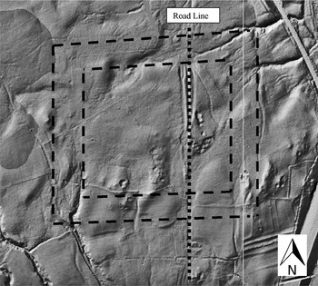
A Roman marching camp of 15.2 hectares (37.7 acres) has been discovered by Bryn Gethin on lidar imagery supplied by the Environment Agency ( fig. 4). The north-west corner of the camp was noted on a lidar image in mid-2010, but it was not until October 2011 that it was realised that three sides of the camp could be seen on aerial photographs available on the internet (Google Earth). The site was visited in June 2012 by Hugh Toller, who discovered the existence of a well preserved eastern gate with traverse, proving beyond doubt that the earthwork was a marching camp. A survey was carried out in September 2012.
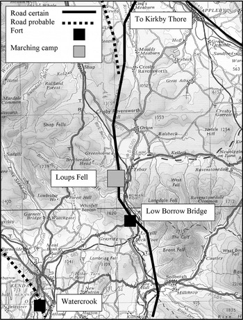
The centre of the camp is at NY 607 044 ( fig. 1). The camp lies on the north-eastern fringe of the Lake District on a spur of Summer Howe known as Loups Fell (pronounced ‘Lowps’ Fell locally). The main Roman road northwards from Ribchester emerges here from the gorge of the river Lune (Margary, Route 7d). The Roman fort at Low Borrow Bridge lies 3 km to the south. To the north lies the valley of the headwaters of the Lune between Tebay and Orton, and beyond an easy passage over Crosby Ravensworth Fell leads into the Eden valley running north towards Penrith and Carlisle. To the north-east beyond Kirkby Thore the Roman road known as the Maiden Way passes over the high ground of Melmerby Fell to Carvoran on Hadrian's Wall.
Loups Fell area with nearby known Roman forts and roads.

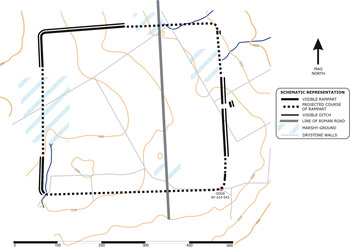
The camp is approximately square in layout. The eastern gate survives in good condition at the mid-point of the east side ( fig. 2). Unfortunately the other gates have been lost. Sufficient of the north rampart survives to indicate that the north gate was placed east of centre, and that the camp would therefore have faced east. The north and south gates probably lay at the point where the Roman road transects the camp on a north–south alignment.
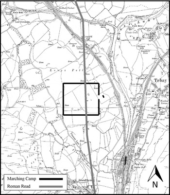
Detailed map of the environs of Loups Fell and the line of the Roman road between Roundthwaite and the crossing of the Birk beck. (Base map Ordnance Survey 1914)

TOPOGRAPHICAL SITUATION
The majority of the area of the camp is uneven marginal land with outcrops of rock. It slopes gradually from west to east and falls away more steeply to the north and east beyond the ramparts. To the south a gentler slope leads down towards Roundthwaite village. The boundary wall between the marginal land and improved land has encroached on the south margin of the camp and all traces of the south rampart have been removed. The north-west corner is the highest point. There is one area of boggy ground in the middle of the west side and from here two streams run downhill; one falls north-east towards the presumed site of the north gate and then continues past the north-east corner of the camp. It has eroded most of the eastern half of the north rampart and the site of the north gate. The second stream runs south inside the line of the west rampart and then out of the area of the camp at the south-west corner. This has created a boggy area around the centre of the western side of the camp that has buried and obscured the site of the west gate. These streams would have provided an internal water source and approximately 10 per cent of the internal area of the camp would have been unavailable for occupation.
Several outcrops of rock sit within the area of the camp. One lies centrally just east of the Roman road line and has been quarried as shown on the 1863 Ordnance Survey first edition six inch map. Another lies under the east rampart to the north of the south-east corner and has also been quarried. A third outcrop lies just outside the west rampart to the north of the south-west corner and overlooks the rampart which cuts the eastern flank of the hillock without deviating from its straight line. This unusual feature is discussed below. Some pre-1863 rectilinear fields have been laid out diagonally over part of the eastern half of the camp that do not respect the ramparts of the camp or the Roman road.
DESCRIPTION
LAYOUT
The camp is almost square ( fig. 3). However, the difficulty of adapting the layout to the terrain has resulted in some slight variations from a square plan. The layout of the camp can be seen clearly on Google Earth imagery where west, north and east ramparts are visible in whole or in part. The north and east ramparts are slightly bowed outwards and the east rampart diverges slightly from the west rampart as it runs southwards. As a result the south rampart is longer than the north rampart. Lidar imagery shows only the north and west ramparts clearly because the line of the eastern rampart coincides with and is overlain by the boundary line between two kilometre squares ( fig. 4).
Plan of the marching camp.

Lidar imagery of the marching camp with the line of the rampart indicated by parallel dashed lines.

CORNERS
The location of the south-east corner has been lost under a field boundary, but the other three corners can be fixed with reasonable certainty. The location of the south-west corner was dictated by a bend in a small stream which required it to be placed to the north-west of the stream. As a result the west side of the camp is shorter and the south rampart longer than if the layout had been a perfect square. The north-east corner is visible faintly on Google Earth imagery, but it is difficult to identify on the ground. Fortunately the survival of the eastern and northern ramparts enables its location to be fixed with certainty. The best preserved corner is the north-west where rampart and ditch survive clearly but in a denuded state. The radius of the curve of the corner here is 10 m.
RAMPART
The lengths of the ramparts are north 395 m, east 385 m (estimated), south 420 m (estimated), and west 365 m. Three clear sections of rampart survive and are described here in a clockwise progression from the site of the west gate now buried in a bog.
The northern section of the west rampart, the north-west corner and the western half of the north rampart survive as a denuded bank and shallow ditch. This shows clearly on lidar imagery ( fig. 4). The north rampart runs east downhill until it is lost in a bog towards the area of the north gate at a point 210 m from the north-west corner. This is over halfway along the north side of the camp and indicates that the site of the north gate would have lain further east and that, therefore, the camp faced east. From here to the north-east corner and just beyond it the rampart is lost in bog or eroded by an east–west stream. Fortunately a short section of rampart survives just south of the north-east corner and this enables the position of that corner to be fixed with reasonable certainty, although traces of it on the surface are very faint.
The east rampart emerges gradually from the rough peaty moor beyond and climbs onto an area of higher ground. This central section is well preserved and survives at best as a rampart 4 m wide and 0.8 m high with a ditch 1 m wide and 0.5 m deep. The east gate lies in this section and remains in good condition. This area has been improved in the past when a rectilinear field-system was placed here in the nineteenth century. Fortunately the east gate and rampart on either side have survived this. To the south of the modern enclosures the rampart survives in rough moor, but has then been removed by a quarry to the north of the south-east corner. To the south of the quarry a faint trace of the rampart survives north of the field wall which is the boundary between Loups Fell and the improved land to the south. It appears to be starting to curve and therefore the position of the south-east corner can be estimated to be approximately where the rampart line runs under the field wall.
The south rampart has been lost in the improved land, but the line can be estimated from the position of the south-west corner. Part of the curve of this corner survives to the west of the stream and the rampart runs north from here for approximately 50 m in good condition. Then an unusual feature occurs. The line of the rampart crosses the eastern side of a rounded rock outcrop and the remains of the rampart survive as a shelf cut across the slope of the outcrop without an external ditch. The rampart and the interior of the camp would have been overlooked at this point. This indicates that no variation was made to the rectangular plan of the camp to allow for this outcrop. Beyond here the rampart is lost in a bog as it approaches the site of the west gate.
CAMP LAYOUT AND GATES
The east gate is positioned in the centre of the eastern rampart and is the only surviving gate. It is well preserved. The rampart and ditch cease on either side and there is a gap between them 12 m wide. The gate is protected by a traverse bank and ditch (titulus) 11.5 m long of the same dimensions as the rampart. Unusually it is laid out at a slight angle of approximately 15 degrees to the rampart rather than parallel to it. The gaps between the gate and the traverse are 15 m on the north side of the gate and 18 m on the south. The latter is the correct distance of 60 feet as specified by Hyginus.Footnote 1 The west gate has been lost in a bog, but can be presumed to have lain in the centre of the west side.
As regards the north and south gates we know from the extant unbroken north rampart that the north gate was placed east of centre. We can infer from this that the camp faced east and that the area of the retentura was greater than that of the praetentura.Footnote 2 It is possible that the north and south gates lay where the Roman road crossed the respective ramparts. This would give a ratio between retentura and praetentura of just over 2:1.
There are three irregularities in the layout of the camp: the asymmetry of the east gate titulus, the coincidence of the south-west corner with the line of a stream, and the west rampart running across the east side of a hillock.
THE ROMAN ROAD
Research and fieldwork on the further course of the road has established that the known lengths of Roman road northward from Low Borrow Bridge run to the Roman fort at Kirkby Thore and not to the fort at Brougham. This finding is contentious because it contradicts previous reportsFootnote 3 and reverts to the view held until 1920 by Codrington and others.Footnote 4 It is based on evidence from lidar imagery that was unavailable to Ross in 1920 when he failed to trace the road to Kirkby Thore and was forced to look elsewhere for a destination.Footnote 5 The arguments are complex and will be elaborated in detail in a separate article.Footnote 6
During the survey of the marching camp, fieldwork on the road established that there are substantial remains of the road over Loups Fell and on the descent to the river to the north, but little else to the south apart from a terrace east of the lane to the south of Roundthwaite village at NY 6099 0309. From the village northwards there are no certain traces across farmland, nor initially within the area of the camp where the road runs through an area of bog. The certain remains of the road start with a short length of 8 m-wide cutting at NY 6086 0437 and then a well preserved length of 6 m-wide agger that runs north from this point for 145 m with later road braiding alongside to the east. Then a braided cutting descends the slope into an area of bog and towards the probable site of the north gate of the camp. Beyond the bog and towards the railway crossing at Loupsfell Side other substantial lengths of road terrace and cutting survive in rough ground. Beyond the crossing of the Birk beck the course of the road has been well documented for 9 km to Ewe Close.
DISCUSSION
The size of the camp indicates a force of 7,000 to 10,000 men at a density of men per acre between 192 and 255. This would correspond with known clusters of camps of c. 15–16 ha in size.Footnote 7
The relationship between the marching camp and the road cannot be determined with certainty, because the points where rampart and road intersect are not available for inspection or excavation. The question of the relationship between marching camps and roads requires a separate paper, although some brief observations in this case may be useful.
We know that the Roman army usually took a corps of engineers or sailors with them on the march that followed the advance infantry and cavalry to clear the route for the baggage train. They are described by Josephus as ‘men with tools to straighten the route, level rough places and cut through obstructing woods’.Footnote 8 When Pompey campaigned in Armenia they are recorded by Strabo as having constructed 120 bridges along a river valley to facilitate the passage of the army.Footnote 9 During campaigning the initial passage of a Roman army through a district would have resulted in what Peddie calls an ‘assault’ or ‘tactical’ road. He estimates that it would have taken approaching two days to construct one kilometre of road. Later when the conquest was consolidated by construction of a network of forts, some, but not all, of these tactical roads would have been converted into a more permanent network of ‘strategic’ roads between forts.Footnote 10 We do not know the relative timing of these elements of campaign and consolidation and it is thought currently that there was a significant period of time before the consolidation phase was put into effect. However, the layout and establishment of the roads may have taken place earlier than thought. This would have been more for the purposes of communication and patrolling than supply. The possible relationship here between camp and road may be important in illustrating this process, although there is no certain evidence.
There is circumstantial evidence here that the marching camp respected the line of the road, perhaps only as a tactical road that later became a permanent one. This is not to say that the camp postdates the road, only that a tactical road existed at the time the camp was laid out. It seems clear from our sources quoted above that this would have been possible. Firstly the overall layout of the camp could have been laid out facing in any direction, but it was laid out at right angles to the road line. The probability of this happening at random is small. If one talks in terms of degrees of the compass the probability of a camp alignment and a road alignment coinciding at right angles would be 1 in 90. We can be certain here that the road alignment bears no relationship to the camp and is based solely on topographical concerns on its course northwards. Therefore, if the camp respects the road it must have been laid out at a time when the road existed. We cannot be sure that the position of the north and south gates corresponded with the road line, but it is probable that they lay on or close to the road. We know that they lay east of centre. Secondly on rough upland terrain there is never a perfect area for a camp, but in this case it could have been better laid out facing north-east or south-east, or on the same easterly orientation but slightly more to the west where the land is higher and less boggy. Thirdly the irregularities in the layout of the camp at the south-west corner and where the west rampart runs across the east side of a hillock suggest that the camp was forced to fit a chosen situation determined by other considerations. However, these are not conclusive evidence that the layout was determined by the road line, since camps often have to adapt to local topography in the course of construction. The asymmetry of the east gate titulus is the most unusual feature of the layout of the camp.
We cannot be certain but these three considerations suggest that the marching camp was laid out on campaign with respect to an early ‘tactical’ road on the line later followed by the permanent road, or perhaps that it was an overnight base for a mobile unit at a later date.
ACKNOWLEDGEMENTS
Sincere thanks are due to Mr Mawson of Moor House Farm, Orton and Mr Parsley of Beckside Farm, Roundthwaite who kindly gave permission for the survey and fieldwork to be undertaken. The survey was carried out by Richard and Angela Knisely-Marpole with the walking being done by Bryn Gethin and Hugh Toller. The plan of the camp was drawn up by Richard Knisely-Marpole. We are most grateful to the Environment Agency, Geomatics Group, Bath for licence to use their lidar imagery and to the Ordnance Survey for permission to use quarter inch and six inch mapping.