The American Southwest is remarkable for the abundance and diversity of sustained archaeological research that has taken place in the region, so much so that one focus, prehistoric farming, can be counted as one of the most thoroughly examined research themes in the world (see syntheses in Fish and Fish Reference Fish and Fish1984; Ingram and Hunt Reference Ingram and Hunt2015). In recent years, climate change has captured the attention of archaeologists in this area where traditional arid land farming in marginal environments has existed for over 4,000 years (Merrill et al. Reference Merrill, Hard, Mabry, Fritz, Adams, Roney and MacWilliams2009). Archaeological models emphasize the social and ecological consequences of climate change on agricultural productivity and the distribution of populations in the past with special attention to resiliency and vulnerabilities to catastrophic events (Ingram Reference Ingram, Ingram and Hunt2015; Kohler Reference Kohler, Kohler and Varien2012; Nelson et al. Reference Nelson, Ingram, Dugmore, Streeter, Peeples, McGovern, Hegmon, Arneborg, Kintigh, Brewington, Spielmann, Simpson, Strawhacker, Comeau, Torvinen, Madsen, Hambrecht and Smiarowski2016; Schwindt et al. Reference Schwindt, Bocinsky, Ortman, Glowacki, Varien and Kohler2016; Varien et al. Reference Varien, Ortman, Kohler, Glowacki and Johnson2007). These insights offer ways of knowing that can contribute to the relevance of archaeology for addressing the current environmental crisis. Nevertheless, most archaeological research, including studies that incorporate climate change, also addresses lower order questions, many of which have direct relevance to contemporary issues concerning land and water resources and cultural preservation. This is especially relevant to Native American tribes, who increasingly employ anthropologists, archaeologists, historians, and physical scientists to compile information in support of their efforts to revitalize their culture and to reclaim lost property and natural resources (Darling et al. Reference Darling, Lewis, Valencia and Eiselt2015).
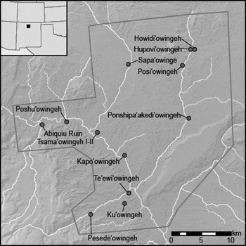
Here we examine how ancestral Ohkay Owingeh (Tewa) people solved the challenges of arid land farming that supported large populations in the Lower Chama Valley of New Mexico during the Classic period (A.D. 1350–1600) (Figure 1). Our case study is based on a specific task assigned to us by the Pueblo: how to establish (based on verifiable scientific data) the size of their priority claim to water in the Rio Chama watershed, an area that encompasses over 1,422 km2 (549 mi2) of core ancestral Tewa homeland. We opted for a regional approach to determine the size of Classic-period villages at peak occupation relative to the extent of agricultural land required to feed the population (Eiselt and Darling Reference Eiselt and Darling2013; see also Duwe et al. Reference Duwe, Eiselt, Darling, Willis and Walker2016). Okay Owingeh then used this information in hydrological calculations to reconstruct water consumption for agricultural production in their ancestral homeland (Gray Reference Gray2013).
Village sites and locations mentioned in the text bounded by GE survey limits. General UTM boundaries are as follows: Z13S, south of N4029002, north of N3991418, east of E382809, and west of E413020.

In an area characterized by diverse agricultural strategies, the challenge faced by all studies of prehispanic agriculture in the American Southwest is how to quantify what you cannot see (or at least what has yet to be recorded). We employed an integrated approach that includes pedestrian survey (ground-truthing), Unmanned Aerial Vehicles (UAVs), satellite imagery (Google Earth), and the supervised classification of aerial imagery to locate fields and to obtain field area calculations for the Classic-period occupation in the lower Rio Chama watershed. This approach provided us with an unprecedented “bird's-eye” view of prehistoric, proto-Tewa agriculture.Footnote 1
Our results reveal a significant bias at the regional scale in the preservation of runoff fields in upland terrace environments above the floodplain of the Rio Chama and its tributaries. However, based on demographic reconstructions (Duwe et al. Reference Duwe, Eiselt, Darling, Willis and Walker2016) and new evidence provided below, it is highly unlikely, if not impossible, that terrace fields could have sustained even a fraction of the Classic-period population. We explore, therefore, whether upland fields could produce sufficient quantities of the suite of staple crops (corn, beans, and squash) necessary to feed the ancestral Tewa and consider what proportion of the agricultural system included floodplain or floodwater farming. Our findings highlight the variety of solutions and human adaptations that once existed in semiarid environments, including the many forms and technologies associated with water transport and irrigation.
Classic-Period Agriculture in the Rio Chama Watershed
Tewa communities employed a variety of farming strategies to secure adequate moisture for their crops. Depending on the water source, these strategies included permanent water irrigation, runoff irrigation, precipitation dependent farming, dry farming, and groundwater farming (Anschuetz Reference Anschuetz1998, see also Mabry Reference Mabry and Diehl2005:124–130). Ford and Swentzell (Reference Ford, Swentzell, Ingram and Hunt2015) list direct precipitation, intermittent runoff, and groundwater (rivers, springs, and high water tables) as the principal water sources for Tewa farming, and they identify no less than 18 different agricultural strategies, grouped by distinct material components and the passive or active management of water in a variety of topographic settings.
Each strategy or technique for water management exhibits technologies and adaptations that serve to conserve, concentrate, and/or convey water to fields, and, under certain circumstances, to take water away or drain agricultural lands (Doolittle Reference Doolittle2000). It comes as no surprise that there can be substantial overlap in the kinds of technologies employed. Ditches or canals serve to convey water derived from both permanent and intermittent (runoff) sources. Likewise, spreaders, diversions, check dams, reservoirs, or retention basins may be used in either groundwater or precipitation-dependent agricultural situations. Such overlaps in technology blur the distinction between what constitutes irrigation and non-irrigation water management based on water source alone.
Scholarly debate over the existence of prehispanic irrigation systems in the northern Rio Grande is ongoing (see discussions in Adler Reference Adler, Ingram and Hunt2015; Anschuetz Reference Anschuetz1998:163–170; Wozniak Reference Wozniak1998:1–12), even though Spanish accounts from the sixteenth and early seventeenth centuries by Pedrosa, Espejo, de Sosa, and others clearly identify the presence of irrigation features (Schroeder and Matson Reference Schroeder and Matson1965:117; see also Marshall and Walt Reference Marshall and Walt2007, Chapter III:18–20). Hammond and Rey (Reference Hammond and Rey1940, Reference Hammond and Rey1966:118, 186, 192, 220) and Bolton (Reference Bolton1908:178) also identify accounts of late sixteenth-century ditches and canals at Acoma and Zuni, as well as the Piro communities of the lower Rio Grande region and at several Tewa pueblos in the Santa Fe Basin. Jusepe Brondate (a member of the 1598 occupation of Yunque'uinge) stated that the people of San Juan Pueblo (Ohkay Owingeh) devoted themselves to agriculture, growing maize, beans, calabashes, fine melons, and watermelons in fields “irrigated by ditches,” while others depended upon “seasonal rain” (Hammond and Rey Reference Hammond and Rey1953:626). As others point out, the issue is not the veracity of these accounts but the scale and antiquity of irrigation in the northern Rio Grande, whether the “ditches” and “canals” described by the Spanish drew water from perennial streams and major rivers, and the degree to which Pueblo farmers relied on groundwater sources for agricultural production (see discussions in Anschuetz Reference Anschuetz1998; Wozniak Reference Wozniak1998).
Despite the ambiguity of historical accounts, it is certain that the indigenous communities of the northern Rio Grande practiced a mixture of irrigated and precipitation runoff techniques at the time of European contact and that some of these techniques involved diversion and irrigation from groundwater sources (perennial springs, rivers, and streams). Anschuetz (Reference Anschuetz1998), Camilli and colleagues (Reference Camilli, Anschuetz, Smith and Banet2012), and Ford and Swentzell (Reference Ford, Swentzell, Ingram and Hunt2015), among others, discuss the manner in which the various parts of a mixed agricultural approach functioned together in the northern Rio Grande to ensure that a certain percentage of mesa-top fields succeeded each year, in conjunction with agricultural areas supplied by more reliable sources of groundwater.
This underlies an important difference in prehispanic versus Iberian irrigation systems introduced after European contact. Prehispanic mixed agriculture was land extensive (accessing multiple dryland and groundwater environments), whereas Iberian (Spanish) agriculture was land intensive, focusing labor investment on permanent irrigation technologies such as canals to irrigate the floodplains using perennial groundwater flows almost exclusively (Anschuetz Reference Anschuetz1998; Lightfoot and Plog Reference Lightfoot, Plog, Fish and Fish1984). In either case—whether it was extensive or intensive—farming practices accessing surface water sources adjacent to major rivers and floodplains or high water tables likely provided a much larger proportion of agriculturally produced foods than has been recognized archaeologically for indigenous populations.
Aerial Imagery and GIS: A Partial Solution to Regional Survey Challenges
In order to address whether terrace farming was sufficient to feed and clothe the population, we must first know the distributions of agricultural sites and features relative to the larger ancestral Puebloan town centers. We also must establish, with some confidence, the locations of agricultural fields and garden areas for carrying capacity calculations. This is typically accomplished through pedestrian survey, which can locate and document field areas relative to major topographic features, sources of water, and habitation sites, but, to do this, one must overcome certain challenges. The core area of the Rio Chama watershed where habitation and agricultural activities took place is large and has not been completely surveyed, and what has been surveyed is limited primarily to areas located above the floodplain. Archaeological records lack sufficient detail to obtain area calculations on geo-referenced fields for carrying capacity calculations, and, where good records exist, researchers have documented some loss of terrace gardens to erosion, burial, and human impacts (Camilli et al. Reference Camilli, Anschuetz, Smith and Banet2012).
Google Earth and UAV Detection
One method uses satellite and aerial imagery, the latter of which has proven successful in the American Southwest since Charles Lindbergh's 1929 flights over the Abiquiú Mesa grid garden complex (Lindbergh et al. Reference Lindbergh, Lindbergh and Mcbrinn2015; see also Anschuetz Reference Anschuetz1998; Anschuetz et al. Reference Anschuetz, Camilli and Banet2006; Camilli et al. Reference Camilli, Anschuetz, Smith and Banet2012; Lightfoot and Eddy Reference Lightfoot and Eddy1995; Marshall and Walt Reference Marshall and Walt2007; Wills et al. Reference Wills, Baker, Baker, Duran and Kirkpatrick1990). Aerial photography is an important tool for archaeological survey in places where the general low abundance of high canopy vegetation facilitates site detection from above (Vogt Reference Vogt1974).
Imagery available through Google Earth (GE) has greatly improved the potential of these methods for archaeological prospection and measurement at low cost using desktop computers (Handwerk Reference Handwerk2006; Parcak Reference Parcak2007; Thomas et al. Reference Thomas, Kidd, Nikolovski and Zipfe2008). Critical to the success of GE for site detection is its ability to drape satellite images over topographic models, enabling one to tilt the azimuth of an image (the viewpoint) and provide a virtual perspective (Kennedy and Al-Saeed Reference Kennedy and Al-Saeed2009; Kennedy and Bishop Reference Kennedy and Bishop2011). This aids in the identification of sites by “orbiting” a view to capture the subtle visual details of features and boundaries that might not be detected otherwise. In recent years, GE can achieve 0.5-m resolution in most places in the United States (Fisher et al. Reference Fisher, Amos, Bookhagen, Burbank, Godard, Whitmeyer, Bailey, De Paor and Ornduff2012:3). Rost et al. (Reference Rost, Wright and Woodson2015) likewise demonstrate that, compared to more traditional CORONA and Landsat ETM+ tiles, GE imagery provides superior spatial resolution for detecting low visibility agricultural features in arid land settings.
We used GE to identify and measure individual agricultural fields. GE allows distance and area measurement of polygons and linear paths with reference to a UTM coordinate system. Image dates ranged from June 16, 2011, to May 31, 2013, and included a maximum spatial resolution of 0.6 m. Terrace borders and grid gardens that are visually located on GE imagery can be digitized to create individual polygons. GE also generates information on the areas, perimeters, and UTM coordinates for each polygon. Polygons can be given unique identification numbers and saved as Keyhole Markup Language (KML) shapes for future reference or sharing in ArcMap GIS or other platforms. Spatial and areal data for shapes can be exported to an Excel file using GE's Point tool (http://www.earthpoint.us/Shapes.aspx) to derive summary calculations for measured polygons grouped by different criteria, such as agricultural feature type or drainage system (Contreras and Brodie Reference Contreras and Brodie2010; Hritz Reference Hritz2013).
Regardless of the apparent benefits, the GE method and the potential for visual bias and human error must be evaluated on the ground through pedestrian survey of agricultural features. We conducted field surveys of 12 areas in two tributary drainages of the Rio Chama, the Ojo Caliente (n = 8 areas, 64.7 ha) and the El Rito (n = 4 areas, 28.3 ha), to investigate the feasibility and accuracy of the GE technique. All survey areas were located on Pleistocene terraces associated with major village sites below an elevation of 1,830 m on landforms that were relatively clear of tree cover or dense vegetation.
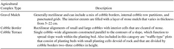
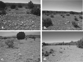
Survey began by identifying a sample of individual mulch garden and terrace fields in GE and obtaining UTM coordinates for each field. The UTM coordinates were transferred to a Garmin eTrex 20 GPS for identification in the field. Four surveyors established a boundary around each survey area containing our agricultural field samples and initiated transect survey at an interval of 20 m between individual crew members until all of the selected area was examined. Upon discovery, the crew assigned each agricultural feature a unique number, and pin-flagged the boundaries, which were measured and located as GPS tracks having <3-m accuracy. Tracks were later uploaded to GE to verify boundary locations. Project personnel relied on the typology of agricultural features adopted by Anschuetz (Reference Anschuetz1998; see also Anschuetz et al. Reference Anschuetz, Camilli and Banet2006; Camilli et al. Reference Camilli, Anschuetz, Smith and Banet2012), recording three major types including gravel mulch gardens, cobble-bordered grid gardens, and terraces (Table 1), which also are visible on aerial and satellite imagery (Figure 2). Field crews noted the locations of borrow pits, rock alignments, shallow ditches, and miscellaneous field-related features including rock piles and rock concentrations.Footnote 2
Agricultural Field Complex Types in the Current Study.

Common agricultural field features in the northern Rio Grande that are visible from the sky: (a) cobble terrace (waffle-type), (b) cobble border, (c) gravel mulch (raised), and (d) gravel mulch with cobble border.

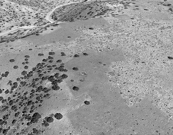
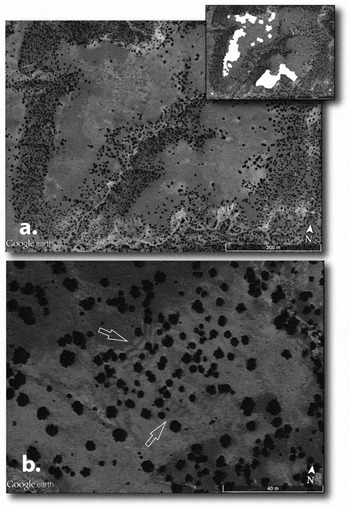
Pedestrian survey recorded a total of 117 agricultural fields and features (94 gravel mulch fields, six cobble-bordered grids, one terrace, and 16 depressions representing borrow pits or reservoirs). A control survey of 8.15 ha in the El Rito drainage encompassed an area that was apparently devoid of agricultural features in GE; we discovered no agricultural features during full coverage survey of this area. Fieldwork demonstrated that gravel mulch gardens, cobble-bordered grid gardens, and cobble terraces are readily identified with GE imagery in certain landscape contexts because their borders are well-defined, and they present anomalous shapes and color changes that are readily identifiable from above. Gravel mulch gardens exhibit “blue-green” geometric forms due to the presence of gravel and associated small grasses and forbs within them. Cobble-bordered grid and terrace features display patterned color variations that form grids or isolated block enclosures (Figures 3 and 4).
Draped GE view of gravel mulch fields along the Ojo Caliente drainage. Modern graphics card capabilities in GE aids in the identification of sites by “orbiting” a view to capture the subtle visual details of features and boundaries.

(a) Gravel mulch fields (top view shows digitized boundaries in GE); (b) cobble terrace.

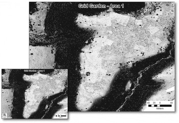
We also used low-elevation UAV technology and associated image enhancement techniques for the detection of partially buried or obscured fields. This included UAV survey in 2013 of approximately 65 ha on Pleistocene terraces above the east side of the Ojo Caliente drainage near Gavilan.Footnote 3 The UAV flight pattern covered one of the pedestrian survey areas that also contained numerous gravel-mulched fields identifiable in GE. UAV output was processed using an X-shading (exaggerated shading) enhancement technique to improve the visibility of surface detail in extremely low-contrast 3D data (Rusinkiewicz et al. Reference Rusinkiewicz, Burns and DeCarlo2006). X-shading also analyzes the 3D model and determines areas of maximum occlusion. The areas of occlusion are then mapped to a two-dimensional image. For the garden data, this meant that the fine variations in detail and elevation could be enhanced for easier discovery. The lower image in Figure 5 includes the boundaries of gravel mulch gardens that were recorded during pedestrian survey using a Garmin GPS and shows additional plots not identified on the ground, which were identified using 3D enhancement. UAV survey demonstrates that GE reconnaissance is an effective method for the detection of gravel mulch gardens, although both techniques (survey and satellite image interpretation) are necessary to visualize extensive agricultural feature complexes in their entirety from the standpoint of identification, geo-location, and detailed mapping.
UAV Survey Area 1 detail with X-shading enhancement. The lower image includes boundaries for gravel mulch gardens recorded during pedestrian survey. Note that several plots (right side of image) were not detected during pedestrian survey.

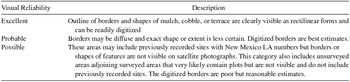
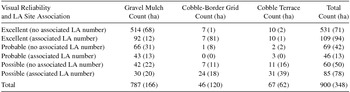
We identified and delineated agricultural features in GE by visually scanning all the major tributaries within the study area over the course of 27 hours, including replicate scanning sessions (see Figure 1 for GE survey boundaries). Replicate scanning involved multiple examinations of the study area to facilitate pattern recognition and to verify garden boundaries. Inclusion of 1,371 known archaeological sites confirmed GE visual identifications and identified the locations of some features and sites that were not visible, primarily due to vegetation cover. Once located, we digitized the visible boundaries of a field or agricultural feature by hand to create a measurable polygon or shape. We also coded each shape according to feature type, gave each a unique number, and recorded its area. Table 2 lists the feature type and reliability scale used for GE image interpretation, and Figure 6 displays the locations of fields discovered by this method. Post-fieldwork analysis of our results leads to several conclusions about the effectiveness and inherent limitations of the GE method and pedestrian survey on Pleistocene terraces and mesa tops above drainage floodplains (see Supplemental Text).
Visual Reliability Scale Used for GE Image Interpretation.

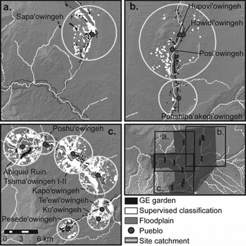
GE dry-farming areas (visually sited in black) versus potential dryfarming areas (in white) identified using the GIS supervised classification technique filtered by a 10-degree or lower slope (Hudspeth Reference Hudspeth2013). GIS search areas were constrained by catchments associated with each of the Classic-period ancestral villages/towns (Pueblos) shown.

Supervised Classification of Potential Field Areas
In addition to pedestrian survey and field identification using GE, we employed a supervised classification of aerial imagery to identify terrace fields and to supplement the more conservative GE study. Image classification is a remote sensing methodology that uses multiband aerial or satellite imagery. Multiband imagery consists of stacked images (or bands) that are recorded for a single landscape scene. Each band represents the reflection of light in a specific, narrow range of wavelengths of the electromagnetic spectrum. Different kinds of surface features on the ground differ in the relative strength of reflectance (brightness) values across these various wavelengths or bands. The unique combination of reflectance values, therefore, is the “spectral signature” for a certain class of surface features. Classes can include vegetation types, soil types, or other surface phenomena that differ in their spectral signatures. A supervised classification is one in which the user deliberately teaches or “trains” the image-processing software to recognize unique spectral signatures by selecting features in an image that represent predefined classes of interest. Once the user has selected and defined examples of each class, the software uses a Maximum-Likelihood clustering algorithm to assign all remaining pixels in an image to one of the predefined classes, based on the assumption that groups of pixels sharing a similar spectral signature uniquely represent some category of landscape feature. Unlike the approach using GE, the supervised classification has a greater likelihood of overestimating field areas, which then have to be eliminated based on common sense criteria related to slope or other factors (see Supplemental Text for additional information on this technique).
Hudspeth (Reference Hudspeth2013) used a set of the gravel mulch fields, identified using GE and subsequently verified with pedestrian survey, to develop the supervised classification so that the locations of additional potential fields in areas above the floodplain could be identified and measured. In addition to the subset of grid gardens used in the training exercise, Hudspeth also digitized training areas for four additional landscape classes, including piñon-juniper woodland, modern valley agriculture, grassland, and desert scrubland. For the supervised classification, he used the red, blue, and green visible wavelength bands from aerial imagery distributed as part of the National Agricultural Imagery Program (NAIP) archive for 2011. NAIP imagery is acquired during the agricultural growing season, thus allowing maximum discrimination of different spectral signatures for different land cover classes and is distributed as a 1-m spatial resolution imagery product by the USDA's Farm Service Agency (FSA). Following supervised classification, all pixels belonging to separate classes were converted into a polygon vector format so that class-specific areas could be calculated using the Geographic Resources Analysis Support System (GRASS) open-source GIS package, version 6.4.3 (for supervised classification and vectorization operations).
The classification located areas of potential fields as pixels or clusters of pixels that have spectral signatures more similar (statistically) to the hand-selected grid garden pixels than they are to the other classes. This system captured all locations on the landscape that are potential agricultural fields, providing a maximum estimate. We improved the technique by limiting classification to landforms with a 10-degree or lower slope, consistent with known locations of archaeologically identified gravel mulch fields and cobble-bordered grid gardens (see also Anschuetz Reference Anschuetz1998; Bugé Reference Bugé, Fish and Fish1984:29; Hill Reference Hill1998; Tjaden Reference Tjaden1979:12 for similar slope values in other areas). Subsetting of the vectorized agricultural areas by slope and radius was performed in the Quantum GIS (QGIS) open-source software package.
The classification was further constrained by fixed catchment radii (based on distance to fields and room counts) surrounding the major village or town sites associated with identified mesa-top and terrace fields (Figure 1). We used catchment thresholds of 2 to 5 km for the radii based on cross-cultural ethnographic data regarding the distances farmers typically walk to access fields (see Arnold Reference Arnold1985:32; Chisholm Reference Chisholm1970:131; Roper Reference Roper1979:120; Stone Reference Stone1996; Varien Reference Varien1999:153–155). To standardize the allocation of land, we assigned a 2-km radius to villages or towns having 1,000 or fewer rooms, a 3.5 km radius to towns having 1,000 to 2,000 rooms, and a 5-km radius to towns with 2,000 or more rooms, assuming that larger villages would require greater amounts of land to support the population. These final processing operations allowed the calculation of areas for the mesa-top agricultural class, as derived in the supervised classification.
Results and Discussion
This study identified a total of 900 individual field areas using the GE survey technique. Table 3 summarizes the total counts and hectares of field types by reliability assessment. A total of 71 percent (n = 640) of all fields received a reliability rating of excellent, meaning that the outlines of field borders and shapes of fields were visible as rectilinear forms that could be digitized readily. A total of 13 percent of fields (n = 115) received a reliability rating of probable, meaning that edges of features were diffuse and therefore the digitized borders represent best estimates for field areas. Five percent of these (n = 46) represent previously recorded sites with area estimates that helped to define field area boundaries. A total of 16 percent of fields (n = 145) received a reliability rating of possible, meaning that the borders or shapes of features are not visible on GE. Where these fields were associated with previously recorded site numbers, field areas were derived from site records.
Results of GEP Satellite Imagery.

Note: LA number refers to the New Mexico state Laboratory of Anthropology site number.
The GE technique resulted in the discovery of 660 new fields or approximately three times the fields that are currently known through pedestrian survey. Gravel mulch gardens account for 87 percent of all fields identified (n = 787), followed by cobble terraces at 7 percent (n = 67), and cobble-border grid gardens at 5 percent (n = 46). Total area represented by GE-defined fields is 348 ha.
The supervised classification of NAIP aerial photos identified a total of 549 ha of potential agricultural fields or plots within the defined radii for all ancestral towns and villages. Confidence in the classification is demonstrated by the degree to which it identifies known garden areas that were not included as training fields in the original classification. Classification identified 68 percent of the known garden areas that were visible in GE. Areas that overlapped with other identifications, such as GE survey or floodplain areas, were removed so that they were not counted twice.
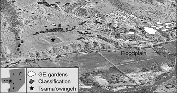
Supervised classification provides compelling observations that are consistent with water conveyance and farming practices described by Ford and Swentzell (Reference Ford, Swentzell, Ingram and Hunt2015). It also identifies instances of potential fields that, in some cases, surround pueblo structures (Figure 7) or that follow tertiary washes and alluvial fans where floodwater farming through overbank and arroyo bottom diversions could have taken place. Such areas remain unstudied, but may yield information in the future through a targeted program of excavation and geomorphological analysis. Consequently, in addition to providing potential maximum estimates for field areas and locations above the floodplain, supervised classification has the potential to guide future survey and excavation projects focused on the recovery of prehispanic agricultural practices in currently unexamined areas.
Detail showing field locations identified by supervised classification and by Google Earth relative to the location of Tsama'owingeh Pueblo.

When combined, the two techniques (GE and supervised classification) identified 897 ha of potential and actual fields above the floodplain of the Rio Chama. Archaeologists working in the American Southwest have used several estimates of per capita field cultivation based on the ethnographic literature of the Rio Grande Pueblos. The figures reported in Lange (Reference Lange1959:426, 438) for Cochiti Pueblo indicate an annual average of 0.31 ha per capita for maize and 0.45 ha (just over one acre) for maize and wheat combined. Ford (Reference Ford1992:156) provides information for Ohkay Owingeh circa 1890 that indicates 0.46 ha in maize and wheat combined. Anschuetz (Reference Anschuetz1998) utilized Ford's estimate of 0.46 ha, adding productivity measures for beans, pumpkins, and squash as well as nonfood cultigens such as cotton, succulents, pot herbs, ornamentals, and medicinal and ceremonial plants, leading to a revised per capita calculation of 0.47 ha to meet the basic, short-term subsistence requirements of prehispanic Tewa populations. Minnis (Reference Minnis1985:186) reached a similar figure of 0.6 ha per person to account for all crops as well as an additional margin for extra cultivation in bad years, whereas Hill (Reference Hill1998) used Bradfield's (Reference Bradfield1971) estimate of 1.01 ha per person for Hopi farmers.
None of these figures have been compared to estimates of population to determine their feasibility, and the higher figures make additional assumptions about variations in productivity that cannot be verified in the study area without additional research. Furthermore, these higher figures assume that farmers at the height of regional population size had sufficient arable land available to plant beyond what was needed on an annual basis. For these reasons, we adopt Anschuetz's more conservative 0.47 ha per person constant, which is inclusive of production of all food- and nonfood-related cultigens per annum. This constant is relevant and appropriate for a consideration of ancestral Ohkay Owingeh farming because it is derived from ethnographic and historic data pertaining to Ohkay Owingeh (Ford Reference Ford1992), it considers productivity estimates for farming areas that include the Rio Chama watershed, and it includes food cultigens and cotton (also a significant staple crop).
Using the 0.47 (ha per capita per year) constant, a population of 1,000 people would require 470 ha of farmland each year to survive. If we consider the results of the GE survey for the entire lower Rio Chama watershed, the 348 ha of constructed agricultural land identified with this method would sustain 740 individuals each year or only 6 percent of the maximum estimated population of 12,975 people based on architectural data (Duwe et al. Reference Duwe, Eiselt, Darling, Willis and Walker2016). Combined, the 897 hectares identified by GE and supervised classification would have supported only 1,908 people or 15 percent of the total maximum population using the 0.47 ha per person constant.
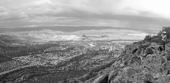
Some additional upland agricultural sites may as yet be undiscovered, but it is clear from the data that archaeologically identifiable, built agricultural space accounts for only a fraction of the area that would be required to support the total population of the Rio Chama at its maximum. This leads us to infer that groundwater and irrigation farming below the mesas must have contributed to the majority of agricultural production needed to provide for the nutritional requirements of the ancestral Tewa residents. To evaluate this hypothesis, we estimated total floodplain area within the fixed radii identified around major village sites. The total area represented by the floodplains is 3,899 ha, which would have supported 8,296 people using the 0.47 ha constant, a figure that is significantly more than our estimate of 1,908 people sustained by terrace farming using the GE and supervised classification techniques. The floodplains of the Chama River and its tributaries, the El Rito, the Ojo Caliente, and the Rio del Oso, must have been prime areas for farming during the Classic period as they are today (Figure 8), despite the contention that lowlands were less attractive for farming due to the risk of catastrophic flooding, pests, and dense stands of vegetation (Glassow Reference Glassow1980; Maxwell Reference Maxwell2000; Maxwell and Anschuetz Reference Maxwell, Anschuetz and Killion1992; Orcutt Reference Orcutt1991; Woosley Reference Woosley1980).
View of the Lower Chama Valley to the north from Abiquiú Mesa showing agricultural fields, the Rio Chama floodplain, and associated terraces where prehispanic farming also took place. Photograph by J. Andrew Darling.

Combined, the maximum population that could be supported by all available arable lands (including floodplain and terraced areas) is 10,204 people (Table 4), assuming that the 0.47 ha constant is a good predictor of per capita investment in agriculture each year. Clearly, the 10,204 estimate falls short of the maximum architectural capacity of 12,975 people calculated on the basis of ancestral town site data (Duwe et al. Reference Duwe, Eiselt, Darling, Willis and Walker2016), but this shortfall represents only 21 percent of the population maximum (n = 2,771 people or 1,302 ha), which can be attributed to adjustments in momentary (rather than maximum) population, total arable land area in groundwater and terrace farming areas, or the hectares per capita per year constant. What is much more significant is the inability of the terrace farming areas to sustain more than 15 percent of the population based on maximum architectural capacity. This further emphasizes the productive role of the floodplains, which, on their own, account for as much as 64 percent of the maximum predicted population of the Chama Valley.
Population Estimates for Classic-Period Villages and Towns in the Rio Chama Watershed.

Floodplain Farming in the Prehistoric Rio Chama Watershed
In 1998, Herhahn and Hill reported that floodwater farming and small-scale ditch irrigation off the Santa Fe River accounted for the overwhelming majority of agricultural productivity at La Bajada Pueblo (LA 7) during the Classic period. Archaeological studies of farming in the Rio Chama watershed similarly have been challenged to find sufficient built agricultural space in mesa-top and Pleistocene terrace settings to sustain estimated populations on the order of 8,000 to 12,000 people during the Classic period (Anschuetz Reference Anschuetz1998; Bugé Reference Bugé, Fish and Fish1984; Maxwell and Anschuetz Reference Maxwell, Anschuetz and Killion1992; see also Lange Reference Lange1959; Lightfoot and Eddy Reference Lightfoot and Eddy1995; Lightfoot and Plog Reference Lightfoot, Plog, Fish and Fish1984; Sandor and Homburg Reference Sandor, Homburg, Nelson and Strawhacker2011 for similar findings in other areas). To overcome these challenges, we employed a bird's-eye view approach that integrates pedestrian survey, GIS technology, and satellite imagery to locate fields and to obtain field area calculations for hydrological assessments. While it is possible that GE and supervised classification can result in oversampling or false positives, these methods balance efficiency and accuracy in developing what are reasonable estimates of the agricultural landscape that was required to support large Classic-period populations. Models of built agricultural space also serve to generate hypotheses regarding demand on the agricultural economy of Classic-period communities and to guide the discovery of prehispanic fields. We conclude that identifiable dryland agricultural space above the floodplains is insufficient to support Classic-period populations based on a conservative estimate of 0.47 ha of agricultural land per capita per year.
This underscores an important conclusion about precolumbian land and water utilization in the Rio Chama basin. In order to support populations in excess of 2,000 individuals (well below any estimate of Classic-period population in the study area), the floodplains and bottomlands of the Rio Chama and its tributaries must have been cultivated. Since water also was undeniably the limiting factor for successful agriculture in the region (closely followed by arable land), water management technologies were an essential requirement and included technology for managing perennial stream or river irrigation and runoff. This also was the case in other parts of the American Southwest, where aggregated populations made extensive use of agricultural facilities that entrained live or groundwater resources for beneficial use in farming and domestic activities.
Such evidence helps to resolve long-standing debates over the existence and antiquity of irrigation prior to European contact in the American Southwest, including northern New Mexico and the Rio Chama watershed. However, prehispanic Tewa farmers did not necessarily construct irrigation works at a scale that could have engendered the development of a complex irrigation society, economic surpluses for regional trade, or social elaborations that some claim account for differences in eastern and western Pueblo cultures (Dozier Reference Dozier1970; Eggan Reference Eggan1950; Parsons Reference Parsons1939; Wittfogel and Goldfrank Reference Wittfogel and Goldfrank1943). Nevertheless, downplaying the productive capacity of the floodplain and the social and cultural implications inherent to surface water irrigation systems similarly disregards aspects of Pueblo coalescence, land tenure, crop allocation, economy, and an array of farming practices that have yet to be studied in detail.
These questions also are relevant to understanding regional patterns of water use, food production, and population expansion that contribute to inferences regarding ancestral Tewa use of upland field systems (and what was cultivated in them) versus the bottomlands. This includes the identification of cotton pollen (Gossypium spp.) in the gravel mulch fields of the lower Chama (see Camilli et al. Reference Camilli, Anschuetz, Smith and Banet2012), as well as pollen from a wide variety of economically important ruderals, native shrubs, herbs, forbs, and not just maize that also occurs in terrace fields (Anschuetz Reference Anschuetz1998; Ford Reference Ford, Minnis and Elisens2000; see also Sullivan Reference Sullivan, Ingram and Hunt2015).
In summary, our bird's-eye view offers a new perspective on the diversity and expansion of ancestral Tewa agricultural economy, one that emphasizes the primary role of the floodplain. The impact of rapid demographic growth during the Classic period resulted in an integrated agricultural infrastructure that linked the large settlements of the lower Rio Chama into the same overarching economy. Understanding the nature and organization of this economy awaits further research that no longer ignores floodplain agriculture and its importance for sustaining large ancestral Ohkay Owingeh populations.
Acknowledgments
We wish to thank the Santa Fe National Forest (Mike Bremer, Forest Archaeologist), the Bureau of Land Management Taos Field Office (Merrill Dicks, Cultural Resources Lead), and the New Mexico State Land Office, Commissioner of Public Lands (at the time of fieldwork, Ray Powell, M.S., D.V.M.; at present, Aubrey Dunn), as well as David Eck (Trust Land Archaeologist at the New Mexico State Land Office) for their support in making this research possible. Nicolas Sternsdorff-Cisterna (Assistant Professor, Department of Anthropology, Southern Methodist University, graciously provided assistance with the Spanish translation of the abstract. We also are grateful for the positive and insightful comments from three anonymous reviewers.
Data Availability Statement
Data generated as part of this project are permanently archived by Southwest Heritage Research LLC and by ArcheoGeophysical Associates LLC and are the intellectual property of Ohkay Owingeh Pueblo, accessible only by written permission of their Tribal Council.
Supplemental Materials
Supplemental materials are linked to the online version of this paper, which is accessible via the SAA member login at https://doi.org/10.1017/aaq.2017.3.
Supplemental Text. GE results and supervised classification multispectral dataset.