Introduction
The fourteenth century was a watershed in the history of Europe, during which centuries of demographic growth were thrown into reverse by successive environmental, economic and epidemiological vicissitudes, a ‘calamitous’ century indeed (Tuchman Reference Tuchman1978). The most iconic of these calamities was the Black Death of AD 1346–1351: an epidemic vividly recorded by agonised contemporary eyewitnesses as it swept across Europe and Asia; its causes and effects have long been hotly debated. For much of the later twentieth century the impact of the Black Death was downplayed. Archaeologists found few proven fourteenth-century catastrophe cemeteries, and they demonstrated that many deserted medieval villages (DMVs)—sites abandoned following medieval occupation—were not depopulated until long after this period (Beresford & Hurst Reference Beresford and Hurst1971). Many historians considered the Black Death to have been a minor Malthusian ‘purgative’, insignificant as an agent of social change that would have happened regardless (e.g. Power Reference Power1918; Bridbury Reference Bridbury1973; Postan Reference Postan1973). Opinion has, however, begun to change. New perspectives on source material have led historians to raise their estimates of Black Death mortality rates from 23–45% (Ziegler Reference Ziegler1969) up to 40–60% (Aberth Reference Aberth2001), and to question its dismissal by earlier scholars (Hatcher Reference Hatcher1994; Campbell 2013), while new techniques have enabled archaeologists to identify previously unsuspected fourteenth-century plague burials in French cemeteries (Kacki et al. Reference Kacki, Rahalison, Minoarisoa Rajerison, Ferroglio and Bianucci2011). The genotyping of Yersinia pestis (YP) DNA found in skeletons from the documented Black Death cemetery in East Smithfield, London (Bos et al. Reference Bos, Schuenemann, Golding, Burbano, Waglechner, Coombes, McPhee, DeWitte, Meyer, Schmedes, Wood, Earn, Herring, Bauer and Krause2011) has not only proved that the Black Death was indeed caused by YP, but also indicated that this was a newly evolved variant—which may help explain its virulence—and the ancestor of all contemporary strains.
These advances in understanding the causes and mortality rate of the Black Death cannot, alone, answer wider questions about the longer social and economic impact of the compound perturbations of the fourteenth century (Nightingale Reference Nightingale2005). A key factor that still impedes progress in this debate is our limited knowledge of demographic change in this period, which lacks comprehensive, consistent, reliable, scalable documentary population data (Bailey Reference Bailey1996: 1–2; Benedictow Reference Benedictow2004: 245–72; Sloane Reference Sloane2011: 103–11).
This paper presents a novel solution to this evidential problem, using tens of thousands of datable pottery sherds newly recovered from nearly 2000 known archaeological contexts within historic rural settlements across six counties in eastern England. It indicates that these data can be used to measure and map, at a range of scales, sustained change in medieval settlement and demography before and after the fourteenth century. This not only indicates an overall drop in activity of nearly 50% in the centuries after the Black Death, but also shows, in detail, which places suffered and in what proportions. These results transcend the limitations of the written record pertaining to medieval demographic change, which are severe in countries such as England, France, Spain and Italy (Aberth Reference Aberth2001: 122–31), but much worse in other areas also affected by the Black Death, including Central and Northern Europe, North Africa, the Near East and the Middle East (Benedictow Reference Benedictow2004: 257). Similar large-scale test-pit excavation could potentially be used to measure and compare the sustained impact of demographic change much more widely.
Project methods
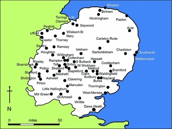
The pottery data derive from more than 50 currently occupied rural settlements (CORS) (Lewis Reference Lewis2005) in eastern England (Figure 1), deliberately avoiding DMVs whose development may be atypical of medieval settlements (Lewis et al. Reference Lewis, Mitchell-Fox and Dyer1997). The pottery was recovered from 1m2 test-pit excavations, one of the few archaeological techniques that can be used within CORS (Gerrard & Aston Reference Gerrard and Aston2007: 244–61), which are by definition covered by contemporary habitation. Being small in extent and quickly completed, test-pits can be used where larger excavations would not be practical or permitted. Pits are sited wherever possible and follow standardised excavation methods (Lewis 2007). The test-pits were all excavated under professional archaeological supervision by members of the public (Lewis 2014a: 321–24); the results are a testament to the thousands of people who contributed.
Eastern England, showing the location of parishes investigated by test-pit excavation within CORS to the end of 2014.

Analysis focuses on pottery because it was extensively used in eastern England in the study period (twelfth–sixteenth centuries AD) and can act as a proxy for human presence. Medieval ceramic vessels were easily broken and difficult to mend, and therefore frequently discarded; sherds are taphonomically durable in most archaeological contexts, relatively easy to see during excavation and sieving, and datable without incurring prohibitive costs. Mapping the distribution of medieval pottery from test-pit excavations within CORS can thus be used with reasonable confidence to reconstruct the extent, date and (to some degree) character of contemporary human activity. Medieval potters produced a wide range of wares, most remaining in production for a century or more (McCarthy & Brooks Reference McCarthy and Brooks1988), but the mid fourteenth century is a watershed, dividing production of high medieval wares (early twelfth to early fourteenth century) from those of the late medieval period (late fourteenth to late sixteenth century). Given the long productive lifespan of most wares, short-term perturbations in settlement and demography are unlikely to register in pottery assemblages, but sustained long-term change will be apparent.
Analysis focused on test-pits producing more than two sherds of pottery for each period. This reflects excavation and field-walking data, which indicate that two sherds within a single m2 are more than would be expected from low-intensity use such as the manuring of arable fields (Haselgrove et al. Reference Haselgrove, Millett and Smith1985; Davison Reference Davison1990; Parker Pearson & Schadla-Hall Reference Parker Pearson and Schadla-Hall1994; Jones Reference Jones2005), thus providing a threshold for activity that may relate to habitation. Negative evidence (i.e. the absence of pottery) is used with caution, with inferences based on several pits in different properties more reliable than those based on single pits. Other indices (e.g. five or more sherds per pit, or the total weight of sherds per pit) demonstrate similar patterns. For example, averaging the data across four very different settlements (the agglomerated villages of Houghton and Wyton; the medieval castle town of Clare; the highly dispersed settlement of Clavering; and the nucleated green village of Great Shelford) reveals that the total number of sherds from all of the pits dropped by 76%; the total weight of sherds by 60%; the number of pits producing five or more sherds by 64%; and the number of pits producing two or more sherds by 54%. Using the latter measure (pits yielding two sherds or more) seems to produce the most conservative results, so it is used in this paper to avoid over-statement.
Test-pit data and the Black Death
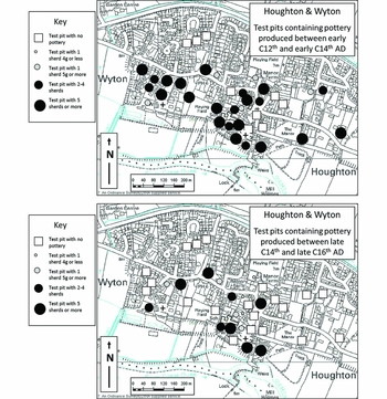
The CORS test-pit programme was originally devised to increase the number of CORS subject to research-driven archaeological sampling in order to advance understanding of the development of medieval settlement plans and patterns over time by redressing the existing bias towards deserted sites (Lewis et al. Reference Lewis, Mitchell-Fox and Dyer1997; Lewis 2007). The observation that late medieval pottery was much more scarce than high medieval pottery was an incidental discovery, first noted in 2005 in the conjoined nucleated Ouse Valley villages of Houghton and Wyton in Cambridgeshire (Lewis Reference Lewis2005: 14). By 2008, of the 37 pits completed there (Lewis 2008: 61), 23 had produced 2 or more sherds of high medieval date, but only 9 had done so for the late medieval period (Figure 2), a drop of 61%. A similar decline was evident in the number of pits producing five or more sherds of pottery, which drops by 60% from 15 to just 6.
Houghton and Wyton (Cambridgeshire), showing the distribution of excavated test-pits and pottery of high medieval (top) and late medieval (bottom) date.

This was valuable for what it revealed about the late medieval development of individual settlements such as Houghton and Wyton, which lack detailed documentary evidence and thus rely more heavily on archaeology. It became much more interesting as the dataset grew, allowing site-specific patterns to be aggregated and wider inferences to be drawn, particularly as the CORS were all selected specifically because they were medieval settlements that did not become permanently deserted or shrunken, but were presumed to have recovered quickly if adversely affected by events such as the Black Death. For example, Cottenham in Cambridgeshire, despite documentary records attesting the death of at least 33 of the 58 tenants on one manor during the Black Death and the presence of ‘ruinous’ houses in the sixteenth century, was considered by historians to have “probably suffered no overall shrinkage” (Wright & Lewis Reference Wright and Lewis1989: 48–54), an inference perhaps given tacit support by the absence of abandoned settlement earthworks of medieval date around the area today.
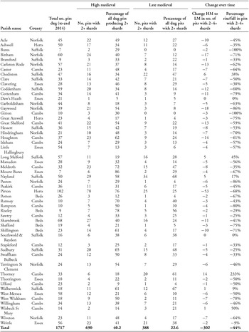
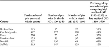
Now that nearly 2000 pits have been excavated, the aggregated evidence from 55 CORS is dramatic (Table 1). Across the East Anglian region, 90% of the excavated settlements illustrate a decline in the number of pottery-producing pits in the late medieval period. Overall, the number drops by 44.7%.
Pottery yields from test-pits excavated in CORS in eastern England until the end of 2014.

Discussion
These results clearly emphasise a dramatic change between the high and late medieval periods. This is itself significant, not least because the data are quantifiable, but we must ask exactly what change this represents. Do the pottery data reflect post-fourteenth century demographic fluctuation or something else, such as a move away from pottery use or changes in rubbish disposal? Contextualising the evidence suggests that the former explanation is correct.
Firstly, there is no evidence for a decline in per capita pottery use in the fourteenth to sixteenth centuries (Dyer Reference Dyer1982) that could account for the decrease in pottery volumes. Certainly there are changes in the types of ceramics in use. Twelfth- to fourteenth-century ceramic vessel assemblages are dominated by three main forms: the cooking pot, the bowl/pan/dish and the jug/pitcher. Although the use of some forms of ceramic cooking pots declined from the mid fourteenth century as metal pot use increased, this coincided with the introduction of a broader range of everyday ceramic items, including pipkins (a form of cooking pot), bowls, dripping dishes, cisterns, drinking cups and jugs, all widely used from the later fourteenth century (McCarthy & Brooks Reference McCarthy and Brooks1988: 102–103).
The reduction observed in the test-pits is also unlikely to result from changes in the disposal of discarded pottery. Field-walking in eastern England typically recovers less pottery of late medieval than high medieval date (Davison Reference Davison1990; Rogerson et al. Reference Rogerson, Davison, Pritchard and Silvester1997; Parry Reference Parry2006). If the same number of people had continued to use the same amount of pottery but removed less onto the fields (which could occur when pottery was incorporated into domestic manure spread on arable fields), we would expect to find more late medieval pottery within CORS, not less. It is thus implausible that reductions in the extent of manured arable land could cause the observed drop in pottery volumes within CORS. Likewise, there is no evidence from field-walking or excavation in late medieval rural settlements for widespread removal of rubbish to settlement margins, or towards pit disposal of refuse. There is also no indication in the test-pit data that differential sherd size is affecting the observed pattern: later wares are not found as consistently larger sherds.
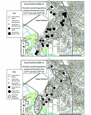
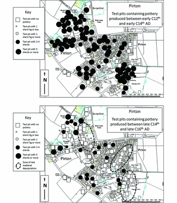
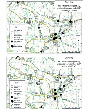
A third point that indicates that the pottery data from the test-pit excavations are depicting a demographic decline, rather than simply a cultural move away from pottery use, is the distribution of pottery within settlements. If a change in fashion had reduced overall pottery use, volumes of pottery would simply be lower, generally, throughout settlements. In fact, the decline is frequently zoned, with some locations continuing to produce pottery in the late medieval period while others nearby do not. In Houghton, for example, the areas south and west of the church seem little affected, while those to its north and east see an 86% drop. Within Great Shelford (Figure 3), nearly all pits in Church Street and High Street yielded later medieval pottery, while those in High Green, Maris Green, Mill Lane and Buristead did not. At Pirton (Figure 4), pottery-rich farms on the edge of the village contrast with pottery-deficient areas near the church and along Royal Oak Lane and Walnut Tree Road. In dispersed settlements such as Clavering (Figure 5), some sites produced late medieval pottery whereas others did not. This zoning is also apparent at a regional scale in inconsistent levels of pottery decline, with some settlements even showing an increase. Several of these, including Nayland and Long Melford, derived considerable wealth from the late medieval cloth trade: these are the sort of places where, if the decline in pottery had been due to changes in fashion driven by rising living standards, we would expect to find less of it, not more, in the late medieval period. Overall, the structured spatial patterning of the pottery data supports the inference that changes in ceramic yields are indeed reflecting changes in population.
Great Shelford (Cambridgeshire), showing the distribution of excavated test-pits and pottery of high medieval (top) and late medieval (bottom) date with zones of late medieval reduction indicated.

Pirton (Hertfordshire), showing the distribution of excavated test-pits and pottery of high medieval (top) and late medieval (bottom) date, with zones of late medieval reduction indicated.

Clavering (Essex), showing the distribution of excavated test-pits and pottery of high medieval (top) and late medieval (bottom) date, with zones of late medieval reduction indicated.

A fourth factor that supports the inference that the pottery data are showing demographic change is that they correlate broadly with historical data. While estimates for short-term Black Death mortality have ranged from about 30% to more than 90% (Sloane Reference Sloane2011: 103–11), there is broad consensus among historians that in England the post-Black Death population fluctuated for the next two centuries somewhere around 30–55% below its pre-Black Death level. The test-pit data, which point to a decline averaging about 45%, sit comfortably within this range. Further corroboration is provided by more specific correlations between test-pit and historical data. Norfolk is the prime example: a county that by the 1330s ‘possessed the highest density of relatively poor tax-payers in the country’ (Campbell Reference Campbell2005: 67). Norfolk exhibits one of the greatest declines in post-fourteenth century pottery yields, reduced across this county by 65% and much higher than in Essex or Suffolk (see also below). These correlations between documentary and archaeological evidence usefully serve to validate each other, as the source data are of course affected by very different biases.
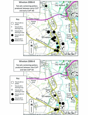
Given the points above, it therefore seems reasonable to infer that differences in the test-pit pottery data do reflect changes in demography. This renders post-Black Death contraction both measurable and mappable. At Cottenham, for example (discussed above), the number of test-pits with two or more sherds drops by 79%, suggesting that the long-term impact of the difficulties of the fourteenth century may have been much greater than the 57% recorded Black Death mortality rate amongst manorial tenants. Also in Cambridgeshire, at Great Shelford (Figure 3) the 41 test-pits excavated showed a decline of around 60% in the number of pits producing two or more sherds, while the number of sherds overall drops from almost 400 to barely 20 and the weight of pottery recovered decreases from nearly 2kg to little more than 200g. Mapping these data reveals that this large village—which in the high medieval period sprawled continuously for more than 1200m from its river-side church along a high street and around two greens—was reduced to a single row running barely 200m immediately east of the church. At Wiveton in north Norfolk (Figure 6), of 23 pits excavated, the number producing 2 or more sherds drops from 11 to just 4, a third of previous levels. Mapping the data similarly revealed that in the high medieval period this coastal village extended for more than 600m around, and north of, the church along the west bank of the tidal river Glaven; it was reduced in the late medieval period to a small core extending barely 200m beyond the church. These figures are by no means the most severe: at Gaywood and Paston (both also in Norfolk), the drop is around 85%.
Wiveton (Norfolk), showing the distribution of excavated test-pits and pottery of high medieval (top) and late medieval (bottom) date.

These are just a few examples of the devastation evident on an eye-watering scale within settlements that have previously been considered the ‘successful’ survivors (that is, CORS that did not become permanently abandoned DMVs), calculated using an index that may be producing conservative estimates. They vividly demonstrate the extent to which our existing maps of late medieval rural settlement contraction (a process continuing in some places well into the seventeenth century), extensively recorded through earthwork survey (such as by the Royal Commission on the Historical Monuments of England in counties including Dorset and Northamptonshire), are in fact showing just the tip of the iceberg of sustained medieval depopulation, whose enormity has hitherto been masked within CORS by eventual post-medieval regrowth. In addition to measuring the extent to which communities contracted, the pottery data are also able to highlight exactly where this contraction was more or less severely felt, at a range of scales: within settlements, we can see which streets, or even plots, were abandoned and which continued to be inhabited; at parish level, which parts of the landscape were more or less severely affected; and on a larger scale, revealing regional patterns.
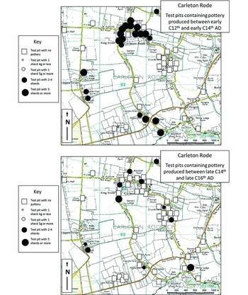
The test-pit data reveal several other interesting phenomena. Firstly, it is clear that contraction did not just affect nucleated villages. This is significant because these are commonly believed to be particularly vulnerable to depopulation, not least because DMVs are most common in areas dominated by nucleated settlement (Roberts & Wrathmell Reference Roberts and Wrathmell2000). But at dispersed Clavering, for example, there is an overall decline of 38% in the number of pottery-producing test-pits. This decline is dwarfed, however by Carleton Rode (Figure 7) in central Norfolk, today highly dispersed. Test-pit excavation showed it to be similarly dispersed in the medieval period, and to have suffered a 62% decline in pottery. All elements of the settlement pattern here were extremely badly affected by late medieval contraction, with several of the isolated sites producing no pottery of this date whatsoever, suggesting that they were entirely abandoned.
Carleton Rode (Norfolk), showing the distribution of excavated test-pits and pottery of high medieval (top) and late medieval (bottom) date.

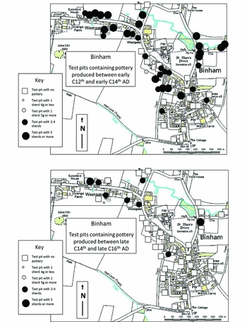
Another phenomenon apparent in the test-pit data is that many larger and higher status settlements appear to suffer as badly as smaller ones: this is noteworthy as the latter are often supposed to be less vulnerable to depopulation (Jones 2010). Cottenham, for example, is noted as “among the largest villages in Cambridgeshire since the 11th century” (Wright & Lewis Reference Wright and Lewis1989: 48–54), but suffered a late medieval decline of nearly 80% in the number of test-pits producing two or more sherds. Many urban or quasi-urban settlements (Beresford & Finberg Reference Beresford and Finberg1973; Letters Reference Letters2005) also fared badly. Clare (Suffolk) had borough status from at least AD 1086, yet saw a late medieval pottery decline of 50%. In Norfolk, markets were operating in Acle and Binham by the thirteenth century, but saw late medieval pottery declines of 45% and 71%, despite Acle being close to both the sea and the major city of Norwich, and Binham (Figure 8) being near the popular shrine of Walsingham. These rural market centres demonstrate an average late medieval reduction in pottery of about 55%, which is higher than the overall average for eastern England of around 44.7%. And yet looking at the 10% of settlements that did not experience sustained late medieval contraction, a common factor is the presence of a commercial base. Nayland and Long Melford (in southern Suffolk) were both heavily involved in the medieval wool trade, and both had a higher number of pottery-producing pits in the late medieval period than beforehand. Walberswick and Southwold, in which pottery yields from test-pits see little change, were both coastal ports trading in fish in Suffolk, a relatively urbanised county with the third highest density of small towns in England by AD 1500 (Bailey 2007).
Binham (Norfolk), showing the distribution of excavated test-pits and pottery of high medieval (top) and late medieval (bottom) date.

Another noticeable pattern is an intra-settlement correlation between specific zones of apparently new high medieval expansion and late medieval decline. At Great Shelford, the Maris Green/High Green areas, largely depopulated in the fourteenth to sixteenth centuries, produced no pottery pre-dating c. AD 1100; the same pattern is evident at Pirton in Royal Oak Lane. It seems plausible that these areas were only used for settlement in the high medieval period in extremis, as pressure on space caused by a growing population became increasingly acute; they were then the first to be abandoned as population contraction eased pressure on space and opened up opportunities to relocate.
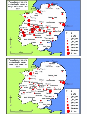
It is also apparent that the scale of decline in pottery volumes varies significantly across the eastern region (Figure 9; Table 2). Settlements in the centre, north and west of the region (including Norfolk, discussed above) fare much worse than those in the south, including Suffolk. Detailed analysis is beyond the scope of this paper, but the correlation of these patterns with variations in land type (Williamson Reference Williamson2003), late Anglo-Saxon settlement (Rippon Reference Rippon2008), medieval field systems (Martin & Satchell Reference Martin and Satchell2008; Oosthuizen Reference Oosthuizen2010), pre-Black Death rural poverty (Campbell Reference Campbell2005) and late medieval commerce (Bailey 2007) points to fruitful avenues for future research.
Settlements in Eastern England included in the CORS project up to 2014, showing the percentage of test-pits yielding two or more sherds of high medieval (top) and late medieval (bottom) date.

Percentage reduction in the number of pits yielding potentially habitative numbers of sherds between high and late medieval periods, listed by post-1974 administrative county.

Conclusion
Scholarly debate surrounding the long-term impact of the perturbations of the fourteenth century and its climactic Black Death has been hampered by the lack of standardised ‘before-and-after’ population data. Data presented here from eastern England indicate that test-pit excavations can reveal changes in medieval demography and settlement that can be both quantified and mapped at a range of scales, liberating scholarly enquiry from the confines of a finite (or indeed absent) documentary record. As a result, we can now say with some confidence that the pottery-using population across a sixth of England was around 45% lower in the centuries after the Black Death than before. Furthermore, we can identify exactly where in the settlement landscape this contraction was most and least severely felt, at scales ranging from plot to region.
This research shows that there is an almost unlimited reservoir of new evidence capable of revealing change in settlement and demography still surviving beneath today's villages, hamlets and small towns. It is tantalising to ponder, for example, how the data for long-term trends in settlement and demography in eastern England might compare with other regions, especially as projects in Hampshire, Leicestershire, Derbyshire and Yorkshire are already proving that the same technique will produce useful results elsewhere (Lewis 2008, 2014b; Denison-Edson & Mills Reference Denison-Edson and Mills2014).
Indeed, this potential extends well beyond England: the economical, nimble methodology of test-pit excavation can be deployed almost anywhere (Turner & Webster Reference Turner and Webster2012; Fernández Mier et al. Reference Fernández Mier, Fernández Fernández, Alonso González, López Sáez, Pérez Díaz and Hernández Beloqui2014). The Black Death spanned 7000 miles from western Europe to eastern Asia: its impact on the subsequent ‘Great Transition’ era, which in turn gave rise to our present world, has been much discussed but with little consensus (e.g. Pei et al. Reference Pei, Zhang, Li, Winterhalder and Lee2015; Campbell in press). Deployed sufficiently widely elsewhere in Eurasia, test-pit excavation could provide new data to inform our understanding of how the world we inhabit today came to be. Moreover, this potential extends beyond the era of the Black Death, as test-pits can produce material of any date that may illuminate demographic change in many periods.
On a final, contemporary note, it is sobering to consider that the sustained post-Black Death demographic collapse and stagnation followed pandemics of plague. This disease is still endemic in parts of today's world and could once again become a major killer, should resistance to the antibiotics now used to treat it (Poland & Dennis Reference Poland, Dennis, Dennis and Gage1999: 55–62) spread amongst tomorrow's bacteriological descendants of the fourteenth-century Yersinia pestis. We have been warned.
Acknowledgements
The excavations discussed here have been funded by Aimhigher, the Higher Education Funding Council for England, English Heritage, the University of Cambridge, the Heritage Lottery Fund, the Arts and Humanities Research Council, Arts Council England and several smaller bodies: their support is gratefully acknowledged. Literally thousands of people have had an essential involvement, and for reasons of space, thanks must be given to them anonymously, remembering especially those who took part in test-pit excavations or permitted these on their property. Special thanks are also due to Catherine Ranson, Clemency Cooper and Paul Blinkhorn, and to the management committee of the McDonald Institute for Archaeological Research, for their valuable support. This paper has benefited from discussion with many people, and I am grateful to them for their illuminating and supportive comments, in particular to James Barrett, Chris Briggs, Matthew Johnson, Stephen Rippon and Barney Sloane who commented on earlier drafts of this paper. Any errors remain, of course, entirely my responsibility.