

For many decades, modern Europeans and North Americans have found it difficult to imagine a city without street names and house numbers. For example, when Walter Benjamin visited Naples in the 1920s, he was surprised to discover that among the locals ‘no-one orients himself by house numbers. Shops, wells, and churches are the reference points.’Footnote 1 Even more so today, without a specific address, how would we find the home of a new acquaintance? How could we open a bank account, or place an order with Amazon.com? And how would the state tax, regulate and keep track of us? Since the eighteenth century, street naming and house numbering have been promoted by businesses and the state. Aided and abetted by the Post Office, publishers of city directories were among the first to list addresses, and to promote their use as part of what Patrick Joyce terms the ‘massified gaze’.Footnote 2 The actual task of assigning names and numbers fell to local government. Numbered addresses became integral to daily life and to effective governance. They also became part of the modern state's ‘geo-locational regime’, by which people and places are made legible to distant rulers and bureaucrats.Footnote 3
So what are we to make of cities where numbering was largely absent? In particular, what can colonial cities such as Bombay, Calcutta, Zanzibar and Singapore tell us about the ability or desire of the state to impose a geo-locational regime, an imperial gaze? How did colonial cities differ from those in Europe, Canada and the United States? Next to nothing is known about the extent of house numbering and its relationship to colonial governance, even though some writers would agree with Peter Pels when he states that ‘governmental notions of population and economy, and the “numbering” they necessarily imply, were pioneered in the colonies’.Footnote 4 The need and the stakes were nowhere higher than in Bombay and Calcutta as their importance to imperial governance and trade called for innovative techniques of management.
In this article, we argue that even though the British may have wanted to impose geographical order upon Bombay and Calcutta, the reality of colonial rule was quite different. Evidence taken from the census, city directories and anecdotal materials indicates that permanent house numbers were rare. People navigated the city in various ways, while the state was unwilling to incorporate houses, streets and neighbourhoods into its calculating gaze.Footnote 5 Despite the evident need to incorporate control over urban social, economic and political spaces, the British did not establish a systematic and unambiguous system of street addresses in Bombay and Calcutta.
House numbering in colonial Indian cities
The growing demand for all forms of social statistics and enumeration practices from the early nineteenth century reflected the long-term rise of anxiety about social change, unrest and public health within colonial cities.Footnote 6 These surveys were part of a broad modernist attempt to make everyone and every place visible, and hence knowable. The idea was to generate more information and to create a different type, a common currency that was standardized so that it was usable by outsiders. In the case of the census and topographic surveys, enumeration established what Matthew Hannah in the context of nineteenth-century America calls a ‘calculable territory’ that enabled the state to ‘rule at a distance’.Footnote 7 Local governments need to establish municipal regimes that enable them to gather resources, to administer to the population and to get to know urban spaces. In Europe, Canada and the United States this involved the creation of a geo-locational regime which consisted of a house-numbering system that formed the basic spatial referencing point for organizing social and economic activity. The development of a coherent and generalized numbering regime ensured that numbers themselves would become embedded into the everyday life of city inhabitants.
Arguably, the impulse to record, count, map and control was nowhere stronger than in India. Censuses were not new to India, having been undertaken by the Mughals and the East India Company. But, as Bernard Cohn has observed, it was the rebellion of 1857 that prompted the British to establish a more systematic enumeration. As elsewhere, the new knowledge often ‘obscured, or denied, local nuances’, as Matthew Edney has noted. Some writers have suggested that, as self-conscious agents of modernization, the British in India pioneered some of the methods of social enumeration that were later applied elsewhere. Certainly, the pressures to do so increased towards the end of the century as rapidly expanding cities became ever more susceptible to labour, social and public health crises. As Gyan Prakash puts it, the British soon ‘hungered for more accurate data to enhance the “taming of chance” in the alien and hostile environment of India’.Footnote 8 But the British accomplished little. Mapping projects fell far short of the ideal, while the colonial census always relied on volunteer enumerators, with attendant problems of motivation and instruction. Sensibly, Patrick Joyce has warned that in India ‘there is an ever-present danger of imagining a prescient, all-seeing state, whereas the state often groped its way along as it went’. We cannot assume that enumeration in all of its manifestations was complete.Footnote 9
Little is known about house numbering in colonial Indian cities. Apart from the small, planned British cantonments that were laid out in the outskirts of a number of cities, the general impression from contemporary accounts is that the practice was not common. In his reconstruction of Old Delhi's morphology, Hasan finds that two detailed, descriptive works published in 1738 and 1827 speak of bazaars, neighbourhoods, chowks (squares), kuchas (streets) and chattas (covered lanes), but he makes no suggestion that they contained house numbers. Similarly, in her study of nineteenth-century prostitution in Bengal, Sumanta Bannerjee reports a contemporary account of unnamed streets in the Calcutta district of Sinduriapatti where ‘dirt-cheap prostitutes live’, and also of an unnamed house occupied by ‘no less than 44 women huddled together’ that had been inspected by an official. In neither case were house numbers mentioned.Footnote 10 More direct, specific evidence suggests that only the better houses had numbers. Writing about the poorer parts of modern Calcutta, Raghab Bandyopadhyay suggests that these can be divided into ‘blocks’, an example being 159 Tiljala Road. This was not a dwelling; it designated an area occupied by perhaps 15,000 people, mostly men, an island in the ‘archipeligos of hutments’. This sort of arrangement had long existed in Calcutta, where clusters of hutments (bustees; bastis) were widely scattered, and interspersed with better dwellings. As one visitor had noted in 1882, ‘hovel succeeds without interval to the palace’.Footnote 11
If it is true that only the better houses were numbered then that was probably because only they were taxed. Historians of Poona and Madras have suggested that, in the pre-colonial era, houses were numbered for tax purposes, but it is doubtful that all were. Indeed, James Frey has suggested that ‘huge numbers of people . . . were allowed to fall between the cracks’. Partho Datta has suggested that the same was true for colonial Calcutta. Numbering for tax purposes is plausible, but leaves two questions unanswered. What proportion of dwellings did the authorities try to tax? Christine Furedy has suggested that a third of late nineteenth-century Calcutta consisted of bustees, and the 1901 census reported that 66 per cent of all dwellings were of poor (kutcha) construction. It makes sense that municipalities would try to tax as many of the other properties as they could, since direct taxation of property owners was their major source of revenue. But we do not actually know that the majority of properties were numbered and taxed. And for those that were, was the system developed for tax purposes also used by other government agencies, including the postal service, or by businesses and local residents? In sum, did they become house numbers in the full sense of the word?Footnote 12
To address this question in a systematic way, we examine Bombay and Calcutta, at the turn of the twentieth century. These were the two largest of India's three ‘Presidency’ cities, the third being Madras. This gave them equivalent, and unusual, legal powers and governmental autonomy. Both were vital coastal hubs of colonial trade and had grown rapidly in the late nineteenth century at a time when many inland cities had stagnated or even declined in population. Although there were differences in detail, both were ethnically diverse, including substantial Muslim minorities within the dominantly Hindu society, and where a tiny British elite exercised disproportionate power. The evidence for these two cities is complementary, and in that sense does not support a properly comparative treatment. Published census reports provide exceptionally rich information about the challenges that enumerators faced, including those connected with the identification of streets and dwellings, in Calcutta, but not for Bombay. Conversely, the sorts of small-area census data that can help us to interpret information in city directories was published for Bombay, but not Calcutta. And so, of necessity, we have constructed an analysis that proceeds by triangulation. In the study of Bombay, we rely on a city directory to determine the residential and business geography of house numbering in 1900. For Calcutta, we use census records to illuminate the existing, imperfect numbering of houses for tax purposes, as well as the temporary arrangements made for each decennial census. Although both sources have limitations, they do provide systematic insights into street naming and the numbering of houses in Bombay and Calcutta. The result is that we are able to draw some important conclusions about house numbering in the Indian colonial city.
House numbers in the Bombay city directory
At first glance, some contemporary accounts might seem to imply that the numbering of houses had become something like the norm in Bombay by the late nineteenth century. As early as 1873, it was reported that confusion was rife because many dwellings had ‘four different numbers painted’ on them, and that the city commissioner was determined to resolve the issue ‘on a correct system’, such as using odd and even numbers on alternate sides of the street. It is unclear whether the commissioner ever tried to carry this through but, by the late 1890s, reports in the Times of India implied that numbering was common. In 1898, for example, district committees that were carrying out inspections in connection with the plague epidemic complained that they were being hampered by the fact that many house numbers had been obliterated. Three years later, the municipal commissioner asked for the house numbers of inspected properties whose owners were being required to make improvements. In neither report was there any suggestion that many numbers were likely to be missing. But, in fact, that was almost certainly the case, or, at least, they were so chaotically ordered as to be of little use.Footnote 13
This is shown in our analysis of the 1900 directory for Bombay, which demonstrates that the vast majority of houses and businesses in colonial Bombay did not have a functional house number. Historians of British and North American cities have made extensive use of directories, which were being published annually by the end of the nineteenth century. Colleagues report that they were not produced in most British colonies, although India is an exception.Footnote 14 There, perhaps building on the lists of associations and local elites that were prepared by administrators, and also the official gazetteers, directories were being produced irregularly in major cities by the late nineteenth century. The Thacker company produced a Bengal directory and then, from 1885, one for India as a whole, and in about 1900 they published their first for Calcutta alone. At about the same time, a Bombay directory was compiled by the Times.Footnote 15 The main limitation of all directories, of course, is that they fail to include every property, especially those occupied by the poor and marginalized.
Such limitations were strikingly apparent of the Times’ directory of Bombay in 1900.Footnote 16 This publication listed 2,116 businesses, organized by ‘Native Firms’, ‘European Firms’, ‘Professions and Trades’ and ‘Public Offices’, as well as separate residential names for ‘residents’ (mostly Europeans), Parsis, Hindus and Muslims. By any reckoning, the residential listing was incomplete: a total of 7,626 people were included, less than 1 per cent of the city's population. If these people are regarded as ‘heads of households’, and depending on what one assumes about the size of the average household (with resident servants), about 10 per cent of dwelling units might have been counted. Alternatively, the figure may be compared with the 31,000 residential units that were identified in the 1901 census, a figure which included bungalows and huts, but also innumerable multi-unit chawls. Clearly, the directory included only a small minority of Bombay's dwellings, and these were those of the social and economic elites.
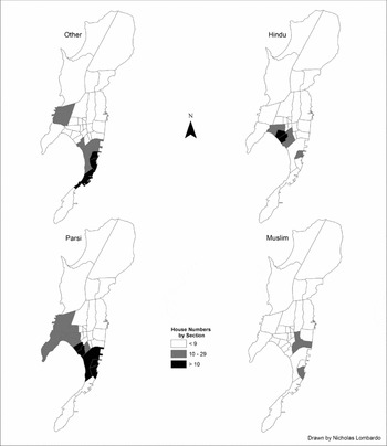
Given that those included in the directory were deemed in some way to be notable, it is striking that only 18 per cent were given house numbers, that is, 1,308 of the 7,626 dwellings listed. The rate varied across the four groups, being highest (30 per cent) among the Parsis. Interestingly, European ‘residents’ were the least likely to live at a numbered address. Perhaps they were sufficiently well known, prominent or concentrated that they could easily be found by name alone. Certainly, we might expect them to be concentrated. Although, as Sidney Low noted in 1911, Europeans in the large port cities were ‘not shepherded apart in cantonments’, as they were in many smaller urban centres; rather, he explains that there were ‘many Englishmen in Bombay who have lived in the city for years, and have never been in a native house’. As Jim Massellos has more recently pointed out, they were part of a ‘foreign universe’, a world separate from most of the Indian population.Footnote 17 And indeed, when mapped, the numbered listings show marked concentrations. It is not possible to be precise about this. In the absence of maps with house numbers, it was rarely possible to find the exact location of a numbered address.Footnote 18 However, with ingenuity we were able to locate 1,187 addresses, 91 per cent of the numbered total, within one or other of the 32 ‘sections’. Mapped at that scale, the most striking feature is the prominence of Modern Town, the city's central business district, which boasted 63 per cent of all Europeans, and 52 per cent of the city's most influential Indian business group, the Parsis (Figure 1). Smaller numbers of listed Europeans and Parsis were also concentrated in the middle-class western areas of Dhobi Talao, Walkeshwar and Mahalaxmi. By contrast, the numbered listings for Hindus and Muslims were concentrated in recognized ethnic neighbourhoods, with 78 per cent of Hindu listings in western parts of the native town or adjacent areas, while 63 per cent of the Muslims listed were to be found in the eastern districts.
Number of residences with house numbers, Bombay, 1900. Source: The Times of India Bombay Directory (Bombay: Times of India Steam Press, 1900).

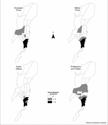
Numbering of businesses followed a similar, if even more striking, pattern (Figure 2). The vast majority of businesses and public offices with numbered addresses were located in Modern Town, 81 per cent of the total and fully 95 per cent of those owned by Europeans. Much smaller and more dispersed concentrations of Indian businesses were located outside the central business centre. Professional and trade firms, especially, lay outside the imperial core. But, again, these were barely the tip of the iceberg. The census reported that there were more than 4,000 business establishments and public offices in Bombay in 1901, and this enumeration did not include a much larger number of petty traders, street vendors and stalls found in the city bazaars. Even though the directory listed 2,116 businesses and public offices, only 365 of these had a numbered address. Most of these were business firms. More than half of the European manufacturing and mercantile companies based in Bombay listed a house number. This was also true of a substantial proportion of the Jewish, Parsi, Muslim and Hindu firms with direct connections to imperial trading and industrial networks. The number of the smaller professional and trade businesses that serviced local demand was much smaller and, not surprisingly perhaps, these firms tended to be found outside Modern Town. The city's public offices, however, uniformly lacked numbers. The Post Office had a street address, while a few offices such as the Military Examination Committee were found in a building (the Town Hall), and others such as the House of Correction were listed by district (Byculla). Although it is impossible to estimate with any degree of certainty how many of the city's businesses had house numbers, the directory suggests that perhaps less than 1 in 100 functioning Bombay business establishments and public offices in 1900 had a house number.
Number of businesses with house numbers, Bombay, 1900. Source: The Times of India Bombay Directory (Bombay: Times of India Steam Press, 1900).

For Bombay, then, the directory evidence indicates that house numbers were so unusual as to be rare. At home and at work, they were infrequently used by, or for, the city's most prominent citizens, firms and public offices. This suggests that both European and Indian elites functioned in well-known, clearly defined and specific circuits of interaction. European merchants and manufacturers’ agents knew to find the business offices of Tata and Co., commission merchants, in the Victoria Buildings. Similarly, the small number of streets that functioned as business streets for the city's imperial economic sector ensured that an address such as Esplanade Road, near Watson's Hotel, was sufficient information for most business people. The world of imperial business was a small one. While the residential world may have been larger, the same holds for the city's wealthy and professional classes. The city's European and Indian elites knew the spatial co-ordinates of their world and did not need house numbers to navigate the city. But was the same true for the city masses? Perhaps, contrary to intuition, numbers were more common among the poor, and in the winding streets of Indian Town. The census, which reached, or attempted to reach, into even the narrowest gulli, allows us to check that possibility. In order to take advantage of exceptionally detailed administrative records, to explore the census it is useful to turn our attention to Calcutta. This was a city comparable in size to Bombay and, moreover, the centre of the British administration.
House numbering in the Calcutta property records and census
Census records for Calcutta indicate that neither the property tax system nor the census itself, which undertook a thorough survey of dwellings every 10 years, produced a permanent and comprehensive system of house numbering. The British regularly put temporary numbers on every building, but did not translate this into a permanent geo-locational reference system of spatial knowledge.
As most Indians were illiterate, census enumerators went door-to-door, interviewed residents and filled out the ‘registers’ of information from which tabular material was eventually constructed.Footnote 19 They visited every separately occupied room in every house on every street, checking to make sure that no room was missed or double-counted. To that end, they numbered every house, together with many individual rooms and one-room huts. The numbering they undertook was temporary, being redone every 10 years. This alone is a clear indicator that no complete, permanent system of numbering already existed. More precisely, the extent to which enumerators had to start from scratch is a sensitive indicator of the extent and character of any previous numbering. The challenge is to figure out how enumerators tackled this particular job.
The Indian census had to generate new house numbers each time, and in the process it recontructed itself. A new administrative organization was formed from scratch every 10 years, and so detailed administrative reports were compiled and published after each census.Footnote 20 These indicated how the census had been conducted, what difficulties had been encountered and how they had been overcome, together with suggestions for the future. They provide a rich source of information about the place of house numbers in the enumeration of the Indian population.Footnote 21 At the local level, the three Presidency cities had some power to decide what data to collect, and how to collect it. They published their own reports and, from 1872, the date of the first national census, until 1911, those for Bengal and Calcutta are the most informative. Together with some city newspaper accounts, they are the basis for the following analysis.Footnote 22
The census enumeration was thorough, being based on what one commissioner termed a ‘double enumeration’. Months before the date of the census, staff divided cities into wards, circles and blocks (60 to 80 dwellings), each of the latter being assigned to an enumerator. As time on census day was short, several weeks beforehand, enumerators visited every house to compile a preliminary schedule. This might take several days. Supervisors then checked that enumerators had not missed any dwelling, or item of information. On the evening of census day itself, enumerators simply confirmed and, if necessary, corrected the schedule they had already compiled. Given the high rate of mobility and homelessness, the population counts are open to question, but it is unlikely that many dwellings were overlooked.Footnote 23
In the absence of a systematic house-numbering system, census enumeration relied heavily on property numbers that had been designated for tax purposes. But this proved problematic as these numbers were inadequate and grew increasingly confused.Footnote 24 When properties had been subdivided, subsidiary numbers were assigned so that ‘No. 15’ sprouted ‘15–1’, ‘15–2’, and so forth. This worked for pukka houses; kutcha huts were designated by letters, for example, ‘15–2G, 15–2H’. And, ‘when letters of the alphabet are exhausted’, which commonly happened with clusters of bastis, ‘a number is affixed to the letter as 15–2 Z23’. Worse, ‘huts are constantly being pulled down . . . and new huts have numbers given them’. So, a sequence of dwellings might run 15–2A, 15–3 15–5D2. And, significantly, ‘the numbers themselves were not affixed to the huts’. This system was confusing enough for those who wished to tax properties; it was almost useless for those who wanted to count people. In 1881, Beverley, the local census director, instructed that a complete renumbering be undertaken, without letters, and that the results be marked on ground plans and on dwellings. The latter may have been done sometimes but was soon frustrated. As historians have shown in other countries, residents feared that numbering was meant to identify properties that had previously avoided tax. It did not help that, when assigning numbers, enumerators asked occupants to present rate [tax] bills. As a result, ‘occupiers would either openly refuse to produce the bills or a thousand pretenses would be made for their non-production’. And, once a number had eventually been assigned and marked, the numbering paper or cardboard labels ‘would be deliberately torn down’. Many of the assessment's numbered ‘holdings’ contained no residence. The result was that assessment numbers were in no way equivalent to house numbers. Indeed, they were not even an adequate basis from which such a system could be constructed. As H. Maguire, the 1891 census director, noted, ‘I therefore propose that new numbers be affixed on some system.’Footnote 25
By 1901, city tax assessors had abandoned the idea of trying to number huts individually. Instead, in the case of a cluster of hutments, the ‘rate is levied from the owner of a bustee . . . one assessment number therefore serves for the whole’. Even those properties that were numbered did not display the fact, ensuring that city officers were unable to identify ‘assessment numbers on the spot’. At first, J.R. Blackwood, the city's deputy chairman, supposed that the assessment data could be supplemented, and he asked for a list of the properties that were not on the tax rolls. But the returns proved ‘so bulky that all idea of utilizing the assessment system of numbering had to be abandoned’. The tax numbering was not even very useful for the revenue department. It was further than ever from being a system on which census enumerators, or anyone else, might rely.Footnote 26 Nevertheless, census commissioners continued to invoke the tax-numbering system because there was no effective alternative. In summarizing the procedures used in the 1901 census, Blackwood discussed the drawbacks of tax numbering and then proceeded directly to a summary of the methods that his enumerators used in developing a numbering system from scratch. First, he states, ‘the numbers of the ward and the block were . . . marked prominently on the corner of the block. Houses were then numbered serially within the block from the number one to the number representing the total number of houses in the block.’ Each block was a system unto itself: ‘For the next block a fresh beginning was made with a new number one.’Footnote 27
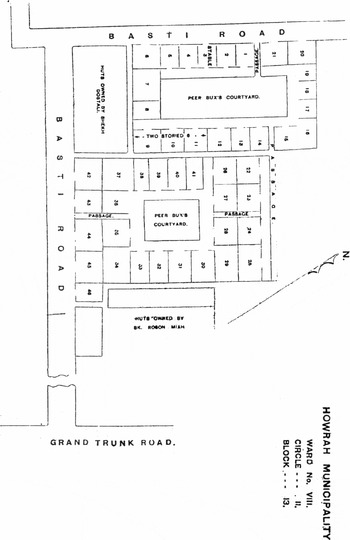
The difficulty of building a permanent numbering system was compounded by the problem of how to define a house. In 1876, Beverley reckoned that ‘a correct census’ could not be based ‘on a register of houses merely’, but that ‘each room inhabited by a separate family was to have a separate number’. This principle was reiterated by E.A. Gait, the commissioner for Bengal in 1901, and spelled out with the help of a sketch (Figure 3). This showed a cluster of 46 hutments in Howrah. One person owned and paid tax on the lot, which counted as ‘one municipal holding’, but each room contained a separate family and for the census received its own number. Easy enough perhaps, but what should be done where two or more families had divided a room with a hanging rush mat? The standing rule, which Gait reiterated, was that one room could not contain more than one ‘house’. This sounded reasonable, but its application posed problems, as reporters noted. One challenge was to make guidelines understandable to a mostly Indian staff whose conception of a dwelling differed from that of the British. Despite repeated instruction, one enumerator cried out, ‘I do not understand these papers. What can I do?’ And so rules were tweaked, amended and sometimes reversed. Even the houses of Europeans caused problems. Should separate servants’ quarters be counted as part of the main dwellings – yes, according to Beverley in 1876 – or should they be enumerated separately, as Gait advised in 1901? Some administrators came close to throwing up their hands. The director of the Lahore census, for example, declared that ‘the term “house” is, in towns, almost incapable of definition’.Footnote 28
House numbering in Howrah Municipality, 1901. Source: J.R. Blackwood, Census of India, 1901. Vol. VII. Census of Calcutta. Town and Suburbs, Part II. Report (Administrative) (Calcutta: Bengal Secretariat Press, 1902), 14.

Why numbers didn't count
As the Bombay and Calcutta cases suggest, the ability and the desire of the British to establish a comprehensive house-numbering system was limited at best. In principle, the colonial authorities in Bombay and Calcutta may have sought to create a legible space through control over street and number. In reality, they were unsuccessful. Given that a permanent system of house numbering has obvious daily utility, its absence in colonial Bombay and Calcutta invites the question as to how residents navigated these cities and why a comprehensive system was not created.
The need for house numbering varied enormously among India's urban populations, and indeed even among the British. Visitors to India, and many long-term British residents, would never have needed to find their way within large parts of Bombay and Calcutta; for them, house numbers in most districts would have been irrelevant, and in their own territory unnecessary. As the Bombay 1900 directory suggests, they navigated within small and insular circuits. While nearly all of their homes and businesses had a street address, very few had a house number. They knew how to find the offices, clubs, chummeries or bungalows of their friends and acquaintances, with only a street name or district as a guide. For the people working within imperial business networks, a score of streets in Modern Town were home to most of the firms with which they needed to interact. Even though the social geography of residence was complicated by class, religious affiliation and neighbourhood, the social circuits and with them the spatial co-ordinates of address were well known. House numbers were rarely needed.
The same was not true for all of those within the colonial administration, including tax collectors and the police, who needed to know how to track properties and, sometimes, people too. The evidence, however, suggests that these authorities rarely relied on house numbering. Numbers would not have been much use since, as Geoffrey Clarke observed, ‘few streets have names’, while ‘addresses tend to be vague descriptions’. This was especially true among the ‘poorer classes’, for whom ‘definite local habitations with names are almost unknown’. The paucity of street names reflected the fact that, in the naming of urban space, Indians attached less importance to streets than to districts. Around 1900, Calcutta, like Bombay, was broadly segregated, and Furedy has suggested that few Europeans ventured into ‘Black Town’. In the ‘intermediate zone’ identified by Sinha, there was ‘a mixture of European and Bengali names’. Significantly, ‘the former pertained to streets; the latter to areas’. Sinha cites Bostompara, a district referred to in contemporary documents, notably wills, but not shown in British maps or directories. Then again, Clarke may have been overstating the point. Sharma implies that, in the Old Town of Rohtak, most gullis did have names, but that these honoured ‘caste, kin, lineage, or a person’. They were known to locals but not recognized by government agencies. The British refused to understand the Indian ways of navigating their cities. In Lahore, for example, the sanitary commissioner in 1897 complained that ‘there are practically no means of distinguishing one street or lane from another in many places, except by the name of some wealthy man's house’. Elaborating, he insisted that ‘in many parts’ of the city ‘there are neither names nor numbers’.Footnote 29
The fact that the British and the Indian elites confined themselves to certain parts of town, so that others remained strange, and possibly threatening, contributed to the inability of the authorities to provide a coherent set of spatial referents. Even though the lines of segregation were blurred, Indian cities were defined by social spaces and a physical layout that were considered unknowable and discouraged investigation by the municipal authorities.Footnote 30 Together, these made any systematic numbering project difficult. Calcutta illustrates the point. Rudyard Kipling complained that ‘there is little regularity in the drift [direction] . . . of what, for want of a better name, we must call the streets’. Even after a lifetime, his local guide commented, ‘some of the streets puzzle you’, while Sidney Low found ‘a rookery of reeking lanes’. Across the Hoogly, industrial Howrah featured a ‘maze of torturous galis’, that, as G.W. Steevens put it, ‘you have to go sideways and edge along the thoroughfares like a crab, so narrow are they’.Footnote 31
The difficulty of knowing Indian districts extended down to the house itself. Outside the well-off areas, high densities, infill and purpose-built tenements created spaces that were not only crowded but confusing, an illegible three-dimensional environment that many observers, including Kipling, condemned as ‘rabbit-warrens’. There was little appeal to the authorities, then, in straying far into an Indian Town district in following meandering streets to a narrow, dead-end gulli, where small entryways gave access to passages and windowless rooms. But that is what would have been necessary for a systematic house-numbering project. Obstacles to the official gaze were obvious.Footnote 32
The reality for most urban Indians was a life without house numbers. Although the majority were illiterate, many maintained a limited correspondence with the help of letter-writers. As a result, about 95 per cent of postal correspondence was sent by, or to, Indians in 1920. While half of this mail was picked up at the local sub post offices, of which there were 63 in Calcutta in 1920, the other half was delivered to a house, almost all of which did not have a house number. According to the historian of the Indian post office, the key was local assistance. Letter carriers were ‘able to get some of the local residents to assist them in decyphering many a doubtful address’, a process that was greatly helped by the fact that ‘people of the same race are accustomed to congregate in the same quarters of town’.Footnote 33 Regardless of what this writer meant by ‘race’, the important point here is that local knowledge was the key to navigating urban space. The rational, modern character of the British and elite Indian space was of little interest to the urban masses. The instrumentality of numbers played little to no part in the legibility of Indian urban space.
For the vast majority of the urban population, local knowledge established the basis for navigating the city. As Jim Masselos has shown, ‘caste-like groups’ formed a geographical aggregation of ‘street, or interlinked network of street, lanes and alleyways’. Similarly, Keya Dasupta has shown for Calcutta that individual groups formed tightly knit geographic communities. It was this that made it possible to know people, and for residents to think of themselves, as ‘“so-and-so of Bhim Nagar” or “such-and-such of x mohalla”’. If the letter carrier was looking for someone, he went to the neighbourhood and asked around. Because the climate permitted it, and severe overcrowding encouraged it, many people spent much of their time on the street, milling around, standing, sitting or squatting. As Sidney Low commented, ‘people roost for hours on the edges of the pavement . . . sitting motionless on their heels, with their hands stretched out over their knees’. In an environment where time was not always money, ‘men sat on the roak [stoop] and read the newspaper, shared stories, and kept an eye on the happenings of the neighborhood’. Here were not only the ‘eyes on the street’ that Jane Jacobs found in Greenwich Village, but ears and tongues as well. Failing all else, shopkeepers ‘knew everyone’. The gullis may have twisted and turned but they were, as Low put it, ‘swarming’ with people, who knew enough to set any letter carrier straight.Footnote 34
With variations, what worked for the letter carrier worked for everyone, including the police. Most of the time, local residents moved in an ‘accustomed space’ that did not extend outside their neighbourhood. When venturing further afield into unfamiliar territory, they – like Benjamin's Neapolitans – navigated by districts and landmarks. An 1886 fictional account of visiting gods touring Calcutta speaks of how the gods saw ‘one pada [neighbourhood] after another’ and a range of shops, bazaars and landmarks. In 200 pages only three streets were mentioned; numbers were non-existent.Footnote 35Bazaars played an important role in navigating the city. These concentrations of shopkeepers were nodes in dense social networks that, apart from customers, included suppliers, assistants, messengers, as well as hopeful hangers-on. In Calcutta, Burrabazar, the central wholesale market, was ‘the central nucleus for the Indian town’. Bazaars were social as well as geographical foci for distinct communities. In Bombay, they produced ‘the idea of a distinctive locality’. Along with residential areas, they helped residents orient themselves, finding and defining their places in the Indian city. House numbers were not necessary.Footnote 36
Conclusion
The absence of house numbers and, in some cases, street names, marked a clear limit to the ability of the colonial authorities to govern. But why were the British so ineffective when it came to creating a systematic house-numbering system? Obviously, there were important advantages to a geo-locational regime in which colonial authorities could know and control the population and city resources. The British, however, were reluctant or unable to enforce a systematic house-numbering system. They seem to have been content to leave the Indian areas alone. As Ian Catanach notes, ‘the nineteenth-century British did not normally see control of the Indian town as a problem of great consequence . . . They did not know all that was happening there, but they did not need to know.’ Similarly, Raj Chandavarkar suggests that the British ‘concentrated on watching its boundaries albeit with a sleepy eye rather than keeping a tight rein on its back streets and by-lanes’.Footnote 37 In other words, the British were unwilling to allocate the resources necessary to establish a systematic numbering system. As Janaki Nair has noted, colonial governance was based on all ‘kinds of compromises’. In this instance, they compromised by ruling through local leaders, by taxing only the better houses, and by leaving the management of tenants in bustees to indigenous agents and elites.Footnote 38
But there is a lurking question as to whether the British would have attempted a thoroughgoing system of numbering even if this had lain within their reach. Speaking of the manner in which Liberals justified colonial rule, Uday Mehta has argued that ‘the themes of opacity, mystery, and unfathomable inscrutability abound’ in British writings about India in the nineteenth century. Certainly, such language pervades descriptions of Native or Black Town. Perhaps for the British, India (including prominent features of Indian society, such as the caste system) did not simply resist comprehension; it was in principle unknowable. Perhaps, then, the idea of urban reform, and the associated apparatus of what Mariana Valverde calls the ‘sunlight of knowledge’, did not come into play.Footnote 39 Using indigenous leaders to help govern Indian Town not only made colonial rule easier, by translating cultural practices it made rule possible. Regardless of the reasons, it is clear that British administrators managed quite adequately without a house-numbering system, while native residents seem to have seen no need for it. As the analysis of the directory and census for Bombay and Calcutta demonstrates, it was perfectly possible to navigate and govern a nineteenth-century colonial city without house numbers.
The Bombay and Calcutta experience of house numbering appears to be true for most, if not all, colonial cities. In the Dutch Indies, major streets had official names but not those in the kampongs, and the government, with its regimes of taxation and regulation, ‘had almost no presence’ until the 1970s. Even where official names had been created, local residents often preferred their own. This was true in Dakar, Zanzibar and Singapore. In French colonial sub-Saharan Africa, it appears that authorities named streets in the city centre but, at most, simply numbered those located in indigenous neighbourhoods. Evidence on the use of house numbers is even thinner. According to some historians of colonial cities that we canvassed, house numbering was rare, or inconsistent. In colonial Nairobi and Georgetown, Guyana, for example, streets were not named and in so far as any site numbering was used this was based on lot and township records. In Egypt, enumerators for the 1917 census were frustrated by the ‘absence or frequent changing of street names [and] the absence of numbers on building and maps of towns’. In French Africa during the late colonial and early post-colonial era, urban growth soon produced ‘unnamed streets and unnumbered buildings’. After several major initiatives and years of trying, the British in twentieth-century Zanzibar were unable to create a systematic regime of house numbers. Annotating the file that recorded this succession of failures, an official gloomily commented that such efforts ‘will never go far’.Footnote 40 The evidence presented here shows that, in colonial India too, he was right.