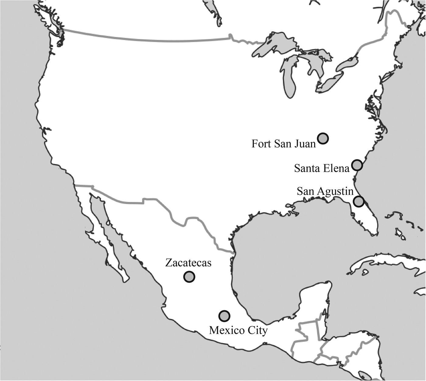
Juan de Tolosa's 1546 discovery of silver along the far northern reaches of colonial New Spain triggered two ambitious efforts to protect these new resources and to establish a permanent Spanish presence in North America's deep interior. In 1570, Viceroy Martín Enríquez founded a network of defensive presidios to protect the road between San Felipe, a colonial outpost north of Mexico City, and Zacatecas, near the point of Tolosa's strike (Figure 1; Moorhead Reference Moorhead1975; Powell Reference Powell1952; Williams Reference Williams2004). Yet, just a few years before, and in part for the same reason, Captain Juan Pardo had built and garrisoned a chain of inland forts from the settlement of Santa Elena, located on the South Atlantic coast, across the Carolina Piedmont, and over the Appalachians (e.g., Beck Reference Beck2013; Beck et al. Reference Beck, Moore, Rodning, Beck, Rodning and Moore2016a; DePratter et al. Reference DePratter, Hudson and Smith1983; Hudson Reference Hudson1990). The viceroy's presidio network would prove to be quite durable, lasting for three decades and expanding from five initial forts to more than 30. Of Pardo's forts, however, only Fort San Juan stood for longer than a year, and it for only about 18 months. Archaeologists and historians alike (including the three first authors here) have often attributed the failure of Pardo's road to Zacatecas both to poor military planning and to inadequate investment of time and labor. The forts were too small and hurriedly built—too insubstantial—to serve as an effective foundation for broader colonial ambitions.
Map of places discussed in the text.

Recent archaeological discoveries at the Berry site, location of Pardo's Fort San Juan and the Late Mississippian town of Joara, offer a challenge to such earlier assumptions. Specifically, the discovery of Fort San Juan itself—after more than 25 years of active archaeological fieldwork at Berry—provides ample evidence that the construction of this garrison represented a substantial undertaking. In fact, Fort San Juan appears to have been a more impressive military fortification than most of those along Viceroy Enríquez's road between San Felipe and Zacatecas. We should consequently look to other reasons for the former's failure and the latter's success. In this article we situate Juan Pardo's expedition from Santa Elena with respect to Spain's broader aims both in New Spain and in La Florida, offering a context for new discoveries at Berry. Next, we summarize the results of our recent excavations, geophysical surveys, and geomorphological analyses at Fort San Juan de Joara. Begun in December 1566, the garrison and its associated domestic compound constitute the earliest European settlement in the interior of what is now the United States. None of Pardo's other scattered outposts have yet been discovered by archaeologists. Indeed, Fort San Felipe at Santa Elena, which Pardo had built in July 1566, is the only other sixteenth-century Spanish defensive work in the American South with comparable archaeological data (e.g., Thompson et al. Reference Thompson, DePratter and Roberts Thompson2016; Thompson et al. Reference Thompson, DePratter, Lulewicz, Lulewicz, Roberts Thompson, Cramb, Ritchison and Colvin2018). Finally, given new evidence for the scope of Fort San Juan, we propose that the social geography of the Native American South, not Spanish ineptitude, posed an insurmountable barrier to the presidio-style system that Spain employed elsewhere in the Americas.
Juan Pardo and the Mines of Zacatecas
In 1546, a Spanish expeditionary force under the leadership of Juan de Tolosa found one of the world's richest silver deposits in the territory soon to be known as Zacatecas, on what was then the northern frontier of New Spain. By 1550, the city of Zacatecas—founded only two years after Tolosa's discovery—had burgeoned into New Spain's second-largest town after Mexico City itself (e.g., Bakewell Reference Bakewell1971:15–20; Carter Reference Carter2009:143). Along with hundreds of Spanish and Indian miners and settlers came the need to effectively move the newfound wealth of Zacatecas south to the colonial heartland, as well as to move a steady stream of supplies from this heartland north to sustain the explosive growth and its yields. Spanish authorities opened a formal highway (or Camino Real) that covered the 650 km of lightly inhabited lands from Zacatecas to Mexico City from 1550 to 1555, replete with licensed inns and staging posts along the way (Bakewell Reference Bakewell1971:20–21).
Yet this rapid expansion of New Spain's reach was not unnoticed by the nomadic groups that roamed the colony's northern frontier. These peoples, known collectively as the Chichimec, were feared and despised by colonial authorities above all others (e.g., Behar Reference Behar1987:116–118; Lewis Reference Lewis2003:108–109). Almost as soon as the road to Zacatecas was opened, its traffic came under relentless attack from these peoples, whose hunting grounds were threatened by the influx of settlers. For the next half century, New Spain waged brutal war against the Chichimec, renowned as “expert archers, brave warriors, and cruel victors, who had a reputation for scalping, dismembering, and eating many of their victims” (Behar Reference Behar1987:116). It was also to these peoples that Church authorities imputed the most dangerous kinds of witchcraft (Lewis Reference Lewis2003:108). Indeed, Spanish anxiety was deep enough that in 1566 Captain Juan Pardo was dispatched from the Atlantic coast to forge a northern route to Zacatecas that might defend against the Chichimec threat (Hudson Reference Hudson1990:130).
Juan Pardo's mission took place in the context of Spain's repeated failures to successfully colonize what is now the southeastern United States. Expeditions under the command of Juan Ponce de León (1521), Lucas Vázquez de Ayllón (1526), Pánfilo de Narváez (1528), Hernando de Soto (1539–1543), and Tristán de Luna (1559–1560) all met with futility in their attempts to establish a Spanish beachhead in this land known as La Florida. Finally, in 1565–1566, Pedro Menéndez de Avilés founded two new settlements along the southern Atlantic coast: San Agustín, established September 1565 in Florida, and Santa Elena, founded April 1566 on present Parris Island, South Carolina. The latter settlement, Santa Elena, was to be the principal town of Menéndez's colonial aspirations (e.g., Hoffman Reference Hoffman1990; Hudson Reference Hudson1990; Lyon Reference Lyon1976, Reference Lyon1984). When Philip II learned of this news, he ordered reinforcements for the colony. In July 1566, Pardo disembarked at Santa Elena with a force of 250 soldiers and quickly set these men to fortifying the settlement. Later that fall, Menéndez ordered Pardo to prepare half of this army for an expedition into the interior lands that lay beyond the Atlantic coast. Pardo's task was to explore this region, to claim the land for Spain while pacifying local peoples, and—importantly—to open an interior road from Santa Elena to the silver mines in Zacatecas. Pardo departed with 125 men on December 1, 1566.
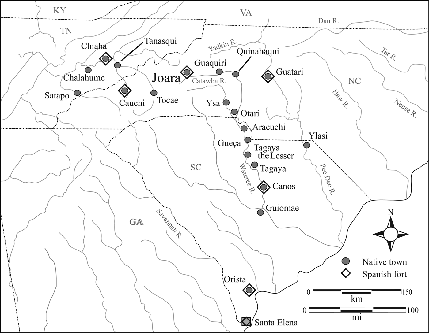
Later that month, after traversing the Carolina Piedmont along the Wateree and Catawba Rivers, Pardo and his soldiers arrived at Joara, a large Native American town situated in the upper Catawba Valley near the eastern edge of the Appalachian Mountains (e.g., DePratter et al. Reference DePratter, Hudson and Smith1983; Hudson Reference Hudson1990). The leader of Joara, referred to in the accounts as Joara Mico (mico was a Native term for regional or multicommunity chief [Anderson Reference Anderson1994; Hudson Reference Hudson1990]), held some authority over nearby villages on the upper Catawba and its tributaries (Beck and Moore Reference Beck and Moore2002:201). Pardo renamed this town Cuenca, after his own native city in Spain. At Joara, he built a fort, christened San Juan, which he garrisoned with 30 men. Although previous expeditions into the interior either had founded seasonal encampments or had temporarily occupied Native towns, Pardo explicitly established Fort San Juan to expand Santa Elena's reach into the northern frontiers of La Florida. In so doing, he founded the earliest European settlement in the interior of what is now the United States (Beck et al. Reference Beck, Moore and Rodning2006). After departing Joara, Pardo and his remaining force explored parts of the Carolina Piedmont to the east of the Catawba River, reaching the central Yadkin River before beginning their return to the coast; they reached Santa Elena on May 7, 1567. During his second expedition (September 1567 to March 1568), Pardo would go on to build five more forts between the Atlantic and what is now eastern Tennessee, yet Fort San Juan was to be the focal point of his imperial designs (Figure 2).
Towns visited by Juan Pardo's second expedition, 1567–1568.

The soldiers of Fort San Juan were garrisoned at Joara as part of a much larger mission to protect Spanish interests from the Chichimec, among the most dangerous Native groups known to New Spain. Moreover, Pardo and his men had good reason to believe that they were closer to the Chichimec heartland than was, in fact, the case. On September 1, 1567, as Pardo left from Santa Elena at the beginning of his second expedition, he carried a written order from Menéndez noting, “You will take the road which seems to you most convenient and direct to go to Zacatecas and the mines of San Martín” (Bandera Reference Bandera and Hudson1990:256). Incredibly, these same commands state, a bit further on, that “you will try to be back in this fort of San Felipe [at Santa Elena] in the course of the month of March [1568] if it is possible” (Bandera Reference Bandera and Hudson1990:257). Thus, Pardo's command was to travel overland from Santa Elena to Zacatecas—and back—in just seven months. Such an order makes sense only in the context of Spanish misconceptions about the continent's vast interior. In the sixteenth century, Europeans had little geographic understanding of those territories north of New Spain and inland beyond the Atlantic, believing this enormous expanse to be much narrower than it actually is (Hudson Reference Hudson1990: Figure 41).
During most of the 18 months that Spanish soldiers lived at Joara, amicable relations held between the people of this town and their Spanish guests. For example, as Pardo readied to leave Joara during the second expedition, he commanded his ensign, Alberto Escudero de Villamar, to “judge and have a care of the conservation of the friendship of the caciques and Indians of all the land” (Bandera Reference Bandera and Hudson1990:278). Yet, in the months that followed, relations between Fort San Juan and the town of Joara took a calamitous turn for the worse. By May 1568, word reached Santa Elena that Indians had attacked all six of Pardo's interior garrisons, including Fort San Juan, and that all were lost (Hudson Reference Hudson1990:176). Several factors must have played a role in this decisive action, but two stand out: the soldiers’ demands for food and their relations—whether coercive or consensual is unclear—with Indian women (Hudson Reference Hudson1990:176). Before leaving Fort Santiago de Guatari, for example, Pardo ordered its officers “that no one should dare bring any woman into the fort at night … under pain of being severely punished” (Bandera Reference Bandera and Hudson1990:285). Ultimately, 130 soldiers and all six of Pardo's garrisons were lost—and with them Spain's final attempt to colonize the northern frontiers of La Florida. More than a century would pass before the next Europeans are known to have penetrated this far into the southern Appalachians.
Fortifying a Road to New Spain
Archaeologists know comparatively little about the sixteenth-century Spanish defenses of La Florida, though archival research and archaeological fieldwork at the sites of Santa Elena and St. Augustine do suggest a surprising range of variation in the configurations, dimensions, and other spatial characteristics of early garrisons (e.g., Deagan Reference Deagan2009; South Reference South1984, Reference South1985; Thompson et al. Reference Thompson, DePratter and Roberts Thompson2016; Thompson et al. Reference Thompson, DePratter, Lulewicz, Lulewicz, Roberts Thompson, Cramb, Ritchison and Colvin2018). Generally, early Spanish defenses consisted of moats or dry ditches, log stockades, and earthen ramparts that enclosed open areas containing wells, pits, and buildings such as casas fuertes—fortified houses that usually maintained a posting of sentries and to which a larger group could retreat if necessary. At the same time, there are cases of early Spanish forts lacking one or several of these attributes (e.g., Deagan Reference Deagan2009:30). Pardo's force built six forts over the course of his two expeditions. Fort San Juan de Joara was founded first, in December 1566, when Pardo also christened its associated settlement the Ciudad de Cuenca (Hudson Reference Hudson1990:153). The fort was named San Juan to mark the army's arrival at Joara on the feast day of Saint John the Evangelist, December 27 (Hudson Reference Hudson1990:147). Unfortunately, no written descriptions or visual depictions of this first garrison are known. Hudson writes that Pardo justified building this fort “to prevent the land from remaining a wilderness (disierto)” (Reference Hudson1990:147), implying that Indian communities were less than civilized. Yet, instead of just giving the name of a Spanish town to a Native community, Pardo intentionally gave the name Cuenca to a new Spanish colonial town, the built environment of which encompassed both a fort and a domestic settlement (Beck et al., ed. Reference Beck, Rodning and Moore2016).
Fort San Juan de Joara was the only garrison established during Pardo's initial expedition into the interior, and although 30 men were officially stationed there, the number actually present at the fort and its associated domestic compound ranged from no more than 10 to as many as 125 over the course of the Spanish occupation. The remaining five forts were all constructed over the course of the second expedition. Hudson (Reference Hudson1990:148) suggests that two of these were built in response to the hostilities that Pardo encountered in the Appalachians during this second entrada. In the summer of 1567, the sergeant left in command of Fort San Juan, Hernando Moyano, had taken a contingent of Spanish soldiers across the mountains and destroyed the town of a cacique, then had continued on to the Native town of Chiaha, probably located along the lower French Broad River in present-day eastern Tennessee (but see Sampeck et al. Reference Sampeck, Thayn and Earnest2015 for a different interpretation of this portion of the route). Moyano's group stopped and awaited Pardo's reinforcement. Pardo began his second expedition on September 1, 1567, meeting Moyano at Chiaha on October 7.
The combined force then continued west to Satapo, where they were warned of a planned ambush by the Indian towns of Satapo, Coosa, and their allies. After conferring with his officers, Pardo decided to turn back. As the army began its retreat from the Appalachians, Pardo oversaw the construction of Fort San Pedro at Chiaha, which was also referred to in the Pardo accounts as Olamico (Hudson Reference Hudson1990:40). The accounts give no details of this fort, but they do record that the army needed four days to build it and to lay out an associated but unnamed town. Pardo left 26 men to hold this westernmost outpost (Bandera Reference Bandera and Hudson1990:274), next in size only to the 31 men whom he would later station both at Fort San Juan de Joara and at Fort Santo Tomás de Canos. Turning southeast from Chiaha, Pardo founded Fort San Pablo at Cauchi, where the chief had already constructed a house for the entrada. The fort was built in three or three and a half days (Hudson Reference Hudson1990:40), but the documents tell us nothing regarding its relationship to the house that the Indians had built. Pardo left 12 soldiers to staff the outpost (Bandera Reference Bandera and Hudson1990:275). Interestingly, these two forts—San Pedro and San Pablo, both located high in the Appalachians—are the only two for which Pardo did not bestow a Spanish name on the settlement, save that of the fort itself. This finding supports the idea that Pardo was not simply renaming Native towns but, rather, was providing Spanish names to the sites of planned garrisons and settlements. Forts San Pedro and San Pablo may thus have been founded primarily as posts to defend this western flank of the road to Zacatecas.
Arriving at Joara, Pardo resupplied Fort San Juan with a larger quantity of materials than any of the other forts received, including additional gunpowder, lead shot, and match cord. Pardo also left the majority of iron shovels, socketed axes, and mattocks at Fort San Juan, as well as the only nails recorded for any of the forts. Once again, he garrisoned the fort with 30 men, this time placed under charge of his ensign, the aforementioned Escudero, to whom he granted authority to govern the other forts from Fort San Juan, to travel among them in order to do so, and to keep the friendship of all the chiefs (Bandera Reference Bandera and Hudson1990:278). This charge makes clear that Pardo planned Fort San Juan as the central outpost of Santa Elena's northern frontier.
Pardo's men built a fourth garrison, Fort Santiago, at the important town of Guatari in the central Yadkin Valley. Pardo named the Spanish settlement here Ciudad de Salamanca (Bandera Reference Bandera and Hudson1990:284). Fort Santiago is the only one of the expedition's six garrisons for which we have any detailed description. According to Menéndez's scribe, Juan de la Bandera, who accompanied the second expedition, Pardo feared that he and his force would be summoned back to Santa Elena to prepare for expected French reprisals, and so they spent only two days building two bastardos, which Hudson refers to as “bastions of earth” (Reference Hudson1990:151). When no summons came, the soldiers took 17 more days building four tall cavalleros of thick wood and earth, together with a wall of high poles and earth (Bandera Reference Bandera and Hudson1990:284). The chief of Guatari offered labor for the construction of Fort Santiago, so Pardo furnished her with a pair of socketed axes to cut wood for the fort. He garrisoned Fort Santiago de Guatari with 17 men.
Neither Pardo nor Bandera provides any description of the next fort, built at Cofitachequi or Canos, which Pardo later gave the name Fort Santo Tomás. He called the planned Spanish settlement there Ciudad de Toledo, and although the army stayed at Canos for 18 days, Pardo left no men or supplies at the fort they had built when he departed (Hudson Reference Hudson1990:151). His sixth and final garrison, Fuerte de Nuestra Señora, was established at the Native town of Orista, just a short distance north of Santa Elena on the Atlantic coast. Its construction seems to have differed from that of the five interior forts, since Bandera (Reference Bandera and Hudson1990:292) records that it was a strong house, or casa fuerte, built of sawn lumber. Pardo christened the settlement Buena Esperança and garrisoned its fort with 13 men. No more is known of either this town or the fort, but the reference to sawn lumber does document that Pardo's force carried saws during the second expedition. From Orista, Pardo sent 31 soldiers—equipped with a quantity of powder, match cord, and lead balls—back to garrison Fort Santo Tomás (Hudson Reference Hudson1990:45). On March 2, 1568, he arrived back at Santa Elena with but a handful of the men who had set forth with him the previous September. By sometime later that spring, nearly all of those whom he had left behind were lost.
Scholars have generally tended to underestimate the investment represented by this string of garrisons. Hudson, for example, suggests that the forts probably “resembled the small, hastily constructed fortifications that Europeans built in other parts of the world” (Reference Hudson1990:152). Similarly, in Childers's summary treatment of La Florida's presidio system from 1565 to 1763, he describes them as little more than a “short-lived series of inland outposts” (Reference Childers2004:24–25), noting only that they apparently were not designated as presidios. Even in our own writing, Beck described Pardo's enterprise as “a series of forts strung like tiny fragile beads from the colony of Santa Elena to the Appalachian Mountains” (Reference Beck2013:60). Yet recent archaeological discoveries have since spurred us to reevaluate these perspectives that have historically minimized Pardo's system. In the section that follows, we present new data from the Berry site in present-day North Carolina, identified as the location of both the Native town of Joara and the Spanish settlement of Cuenca (e.g., Beck et al. Reference Beck, Moore and Rodning2006, Reference Beck, Moore, Rodning, Beck, Rodning and Moore2016b). Specifically, recent excavations and geophysical survey offer unparalleled data on the scope of Pardo's colonial project. After reporting these discoveries, we compare what we refer to as the northern road to Zacatecas with two contemporaneous Spanish presidio systems in the Americas: Menéndez de Avilés's 1565–1569 defenses along the coast of La Florida and Martín Enríquez's 1570 presidio system along the southern road to Zacatecas.
Excavations at the Berry Site
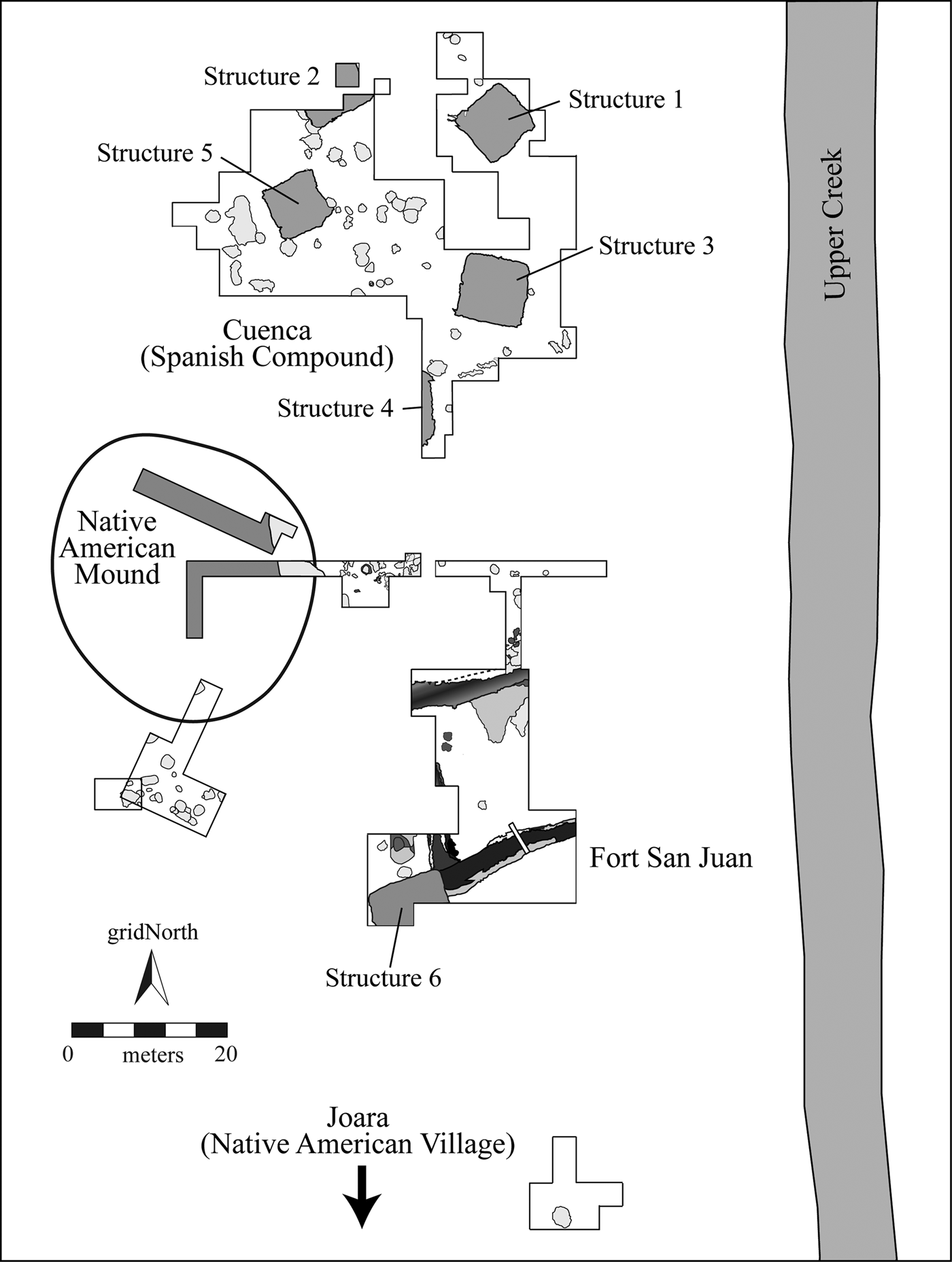
Archaeological and documentary evidence (Beck Reference Beck1997, Reference Beck2013; Beck et al., ed. Reference Beck, Rodning and Moore2016; Worth Reference Worth, Beck, Rodning and Moore2016) indicate that both Joara and Fort San Juan were situated at the Berry site (31BK22). Berry covers 4.5 ha and is located at the easternmost margin of a 75 ha alluvial floodplain along Upper Creek, a tributary of the Catawba River, in Burke County, North Carolina (Figure 3). The Berry Site Archaeological Project has conducted 19 field seasons of excavations and surveys at the site, focusing much of this research on a 0.5 ha area where we have recovered a sizable assemblage of sixteenth-century Spanish ceramics and hardware, along with an array of personal and military goods (e.g., Beck et al. Reference Beck, Moore and Rodning2006; Rodning et al. Reference Rodning, Beck, Moore, Legg, Beck, Rodning and Moore2016). This location, limited to the northeastern corner of the site, is associated with five burned buildings, dozens of large pit features, and many hundreds of postholes, all of which we refer to collectively as the Spanish compound. These are the remains of Pardo's Cuenca (Beck et al. Reference Beck, Moore, Rodning, Sherwood, Horton, Beck, Rodning and Moore2016; Beck et al. Reference Beck, Moore, Rodning, Beck, Rodning and Moore2016b; Beck et al. Reference Beck, Newsom, Rodning and Moore2017).
Berry site excavations, 1986–2016, indicating Spanish compound, mound areas, and Fort San Juan. The north arrow indicates grid north; the 1986 excavations are oriented toward magnetic north.

The Spanish compound had two distinct periods of construction activity. During the first phase, three buildings—Structures 1, 3, and 4—were constructed in a slight arc along the northern edge of the site. This architectural phase may coincide with Pardo's arrival at Joara in December 1566. The central pit features were dug during this first construction phase when Structures 1, 3, and 4 were built; the pits were probably used for processing daub while the buildings were under construction, after which they were filled with refuse. Feature 76, a circular hearth measuring 66 cm in diameter, was located along the eastern edge of the central pits and may have served as an open-air kitchen during the initial occupation. During the second phase of occupation, Structures 2 and 5 were built together on approximately the same axis 15 to 20 m west of the first buildings; each of the two new buildings intrudes into the central features, establishing the temporal priority of the latter. Structure 2 was built in a basin like Structures 1, 3, and 4. Structure 5 is thus an anomaly. Its physical characteristics and spatial location suggest that it may have served as a more formal, enclosed cocina or kitchen (Beck et al. Reference Beck, Moore, Rodning, Sherwood, Horton, Beck, Rodning and Moore2016:139).
Extensive research in the Spanish compound informs the domestic aspects of this colonial encounter. It was here that the soldiers of Fort San Juan passed much of their time. This was where they slept, ate meals, developed personal relationships with one another and with the women and men of Joara, and followed the routine practices of daily life. In other early colonial contexts, living areas such as the Spanish compound were often spatially segregated from defensive works. That is, a separation was maintained between the domestic spaces of a colonial encounter and its monumental zones. In 1588, John Smith reported discovering Ralph Lane's settlement on Roanoke Island some three years after its abandonment; its fort, he wrote, had “sundry necessary and decent dwelling houses made by his men about it the yeere [sic] before” (Quinn Reference Quinn1985:280). Also, French Fort Caroline, established in 1564, was depicted as having houses located beyond the fort (Bennett Reference Bennett2001:19). Such was the model that Pardo followed with the Spanish compound built at the Berry site. What remained elusive, in all of our previous years of fieldwork, was evidence of the fortification itself—Where was Fort San Juan?
We can finally answer that question, but first we will need to introduce another feature of the Berry site's built environment—its earthen mound. During the late nineteenth century, Cyrus Thomas of the Smithsonian Institution referred to the Berry site as a “mound on the west bank of Upper Creek 8 miles north of Morganton (about 15 feet high and unexplored)” (Reference Thomas1891:151). Both the mound and associated site have been continually plowed since the late 1700s, and in the mid-twentieth century the mound was razed to provide fill for a low-lying area that was susceptible to flooding and was the likely location of a borrow pit. In 1986, David Moore conducted fieldwork at Berry that focused on a topographic rise at the northern end of the site that the landowners and collectors identified as the remnant mound. His work included a 3 m × 21 m (10 ft × 70 ft) trench that revealed deposits of “basket-loaded mound fill” (Reference Beck and Moore2002:214–216), and he interpreted these distinctive zones as the mound that Thomas described in 1891. Moore's trench clearly revealed fill zones of a sort typically associated with Native earthen construction (Sherwood and Kidder Reference Sherwood and Kidder2011), and these fills almost certainly represent mound deposits. We had long planned to resolve the stratigraphic relationship between the mound and the Spanish compound, and in 2011 we shifted our attention to an area where we thought we might encounter the southern edge of the mound.
Determining the mound's footprint seemed a relatively straightforward task. In 2007, we opened several excavation units at the southeastern edge of the topographic elevation that we associated with the mound. These units revealed a pattern of horizontal stratigraphy that seemed to follow the edge of the rise and that we thought had resulted from plowing across several layers of truncated mound deposits. This interpretation was consistent with the results of Moore's 1986 excavations in the western and southern portions of the mound and with our original supposition that this elevation was the bulldozed and plowed remnant of the earthen mound that Thomas (Reference Thomas1891) reported as 15 ft high. To obtain greater clarity of these deposits, we returned in 2012 to what we were still interpreting as the southeastern edge of the mound, expanding our 2007 excavation area. Again, as we moved from east to west, the horizontal stratigraphy seemed to correspond to the southern limits of the mound.
Our view changed dramatically, however, as we continued these excavations in 2013. As we moved west, it became clear that the horizontal stratigraphy did not curve to the northwest, as we would have expected if it conformed to the southern edge of the mound, but instead extended straight in a southwesterly direction. Moreover, we recognized that similar stratigraphic deposits turned north at a sharp angle to these original southwest-trending linear bands of fill. It was clear that we were not following the edge of the mound but, rather, that of a very large feature, larger than any feature or structure yet identified at the site. Several days of discussion led to the conclusion that we had exposed the southwestern corner and a portion of the southern side of a moat or ditch. At the end of the 2013 season, we cross-sectioned the southern side of the ditch with an 80 cm wide trench, revealing a V-shaped feature (Feature 224) measuring more than 3 m across and at least 2 m deep. After nearly 20 years of fieldwork, we had finally discovered Fort San Juan.
Exploring Fort San Juan
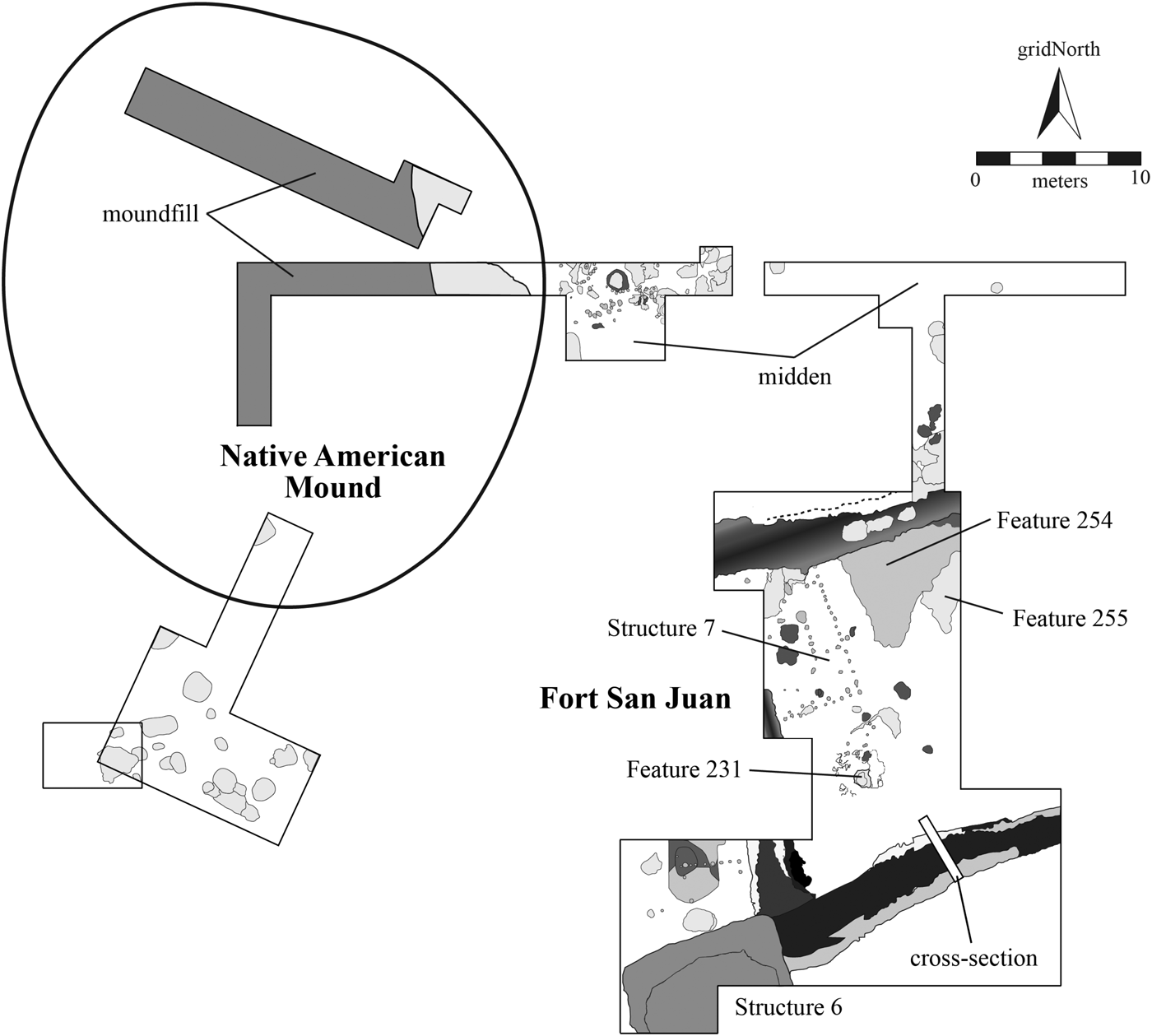
Since 2014 we have removed approximately 240 m2 of plow zone from the archaeological footprint of Fort San Juan (Figure 4). These plow zone soils contain similar quantities of Spanish and Native American artifacts as were recovered in the Spanish compound, but the sub–plow zone soils in and around the fort are extremely complex and as yet poorly understood, due primarily to the extraordinary range of cultural activities that appear to have taken place in this portion of the site before, during, and after the occupation of Fort San Juan. Relatively few features are visible in the subplow matrix, but those that have been identified are intriguing. One of these is a large circular pit (Feature 231) that measures 1 m in diameter and is located in the southwest quadrant of the fort. Significantly, it is surrounded by irregular lenses of gray fine sediment that are likely derived from slack water and are unlike any other deposits observed on the site. We return to this feature in our discussion of the 2014 geophysical surveys.
Fort San Juan excavations, showing areas of plow zone removal through 2017.

Just north of this feature is a rectangular single-post building (Structure 7) that may have been built prior to the fort's construction, as it appears to have been intruded by both the northern and western sides of the dry ditch or moat. Several large postholes inside this structure probably represent roof supports, and two likely hearth features are located near the center of the building. There are additional features along the northern edge of the fort's interior, including a thick clay deposit (Feature 254) that extends over an area of 30 m2 and is as much as 6 cm deep depending on the depth of plowing. It consists of a clean, yellow-brown clay (Muncell 10YR 5/8) found nowhere else on the site. An intentional deposit, it is also aligned parallel to the rectangular post building. Adjacent to this clay is a midden-like deposit (Feature 255) resembling the midden we identified in the western portion of the Spanish compound. Interpreting these deposits on the interior of the fort—especially determining which predate, postdate, or were contemporaneous with the Spanish occupation—will require far more extensive excavations. At this point, we have yet to identify an entrance to the fort, nor can we determine with certainty whether any kind of wooden palisade or stockade lined the interior of the fort ditch. In addition to this program of plow zone removal, we have conducted detailed geophysical surveys of the fort area and excavated a test trench that cross-sections the moat. Here we present new data from each exploratory method.
Geophysical Surveys
In fall 2014 we conducted a series of geophysical surveys at the Berry site, with the aims of defining the overall form and extent of the Fort San Juan ditch, mapping any features and structures associated with the fort and compound, and placing Fort San Juan in the context of the preexisting Native American town of Joara. Due to its location in a floodplain agricultural field, the environmental conditions at the Berry site were generally conducive for pursuing geophysical investigations. Previous magnetometer surveys at the site had shown the potential of this method for detecting a range of anomalies, including burned structures and large features. Each of these smaller-scale surveys concentrated on the known Spanish settlement, and none revealed the location of the fort itself.
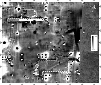
The 2014 magnetometer investigation was conducted using a Bartington Grad601-2 dual fluxgate gradiometer across a total area of approximately 4.8 ha; readings were made at 0.125 m intervals along traverses spaced 0.5 m apart, producing a total of more than 750,000 individual measurements and providing a high-resolution perspective on subsurface geomorphological and anthropogenic anomalies. Not only can we see the distinctive responses of agricultural activities (such as plow scars) and recent archaeological excavations, including the strong bipolar magnetic anomalies produced by iron nails, but it is also possible to identify various pit features associated with both the Spanish compound and the Native American use of the site, as well as larger-scale anomalies caused by paleochannels and other subsoil variations. Although the magnetometer survey covered the entire preserved portion of the Berry site, we focus here on the portion of the survey that covered the Spanish occupation area. We plan to present complete geophysical datasets in greater detail in subsequent publications.
North of where we first identified and cross-sectioned the deep, V-shaped ditch feature in 2013, the 2014 survey revealed that its east, west, and north sides form a continuous and positive anomaly caused by the presence of magnetically enhanced soils in the fill (Figure 5). Variability in the intensity of this anomaly indicates the mixed nature of its fill and suggests that portions of the feature were infilled with burned or magnetically enhanced soils that produced measurements between 5and 12 nT. Weaker sections (<2 nT), in contrast, appear to contain relatively unaltered soil. Interestingly, the less magnetic sections of the feature include areas closest to the burned Spanish compound, suggesting that little in the way of occupational trash and midden material or burned architectural remains ended up in the fill on this northern side of the ditch.
Gradiometer survey (2014) of the fort area, with 2012–2014 excavation areas indicated. All measurements in meters.

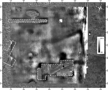
Although the course of the ditch anomaly is relatively clear in the magnetometer data, we conducted further surveys using earth resistance and ground-penetrating radar (GPR), both to more accurately map the horizontal and vertical extents of the ditch—especially on the northwest side where the magnetic response is extremely weak—and to obtain more data regarding potential features located inside the ditch. We undertook earth resistance survey over an area that covered 60 m × 60 m using a Geoscan RM15 earth resistance meter, employing the twin probe array with a 0.5 m electrode separation. Data were collected at a resolution of 0.5 m × 0.5 m. The resulting image (Figure 6) clearly reveals the overall shape of the fort, with the ditch visible as a 1.8 m to 3.0 m wide, low-resistance anomaly, its low resistance due to the less compact and moister fills it contains. Triangular bastions project from the corners of the ditch, producing a distinctive shape that resembles other Spanish forts from this period (Deagan Reference Deagan2009; South Reference South1984, Reference South1985; Thompson et al. Reference Thompson, DePratter and Roberts Thompson2016). The resistance survey provides few data about the interior of the fort, in part due to a relatively coarse sample interval but also due to a high degree of disturbed soil within the deep plow zone. One large, low-resistance anomaly can be disregarded since it resulted from a recent excavation back dirt pile, but areas of slightly higher resistance immediately inside the ditch may indicate traces of a former earthen embankment.
Soil resistivity survey (2014) of the fort area, with 2012–2014 excavation areas indicated. All measurements in meters.

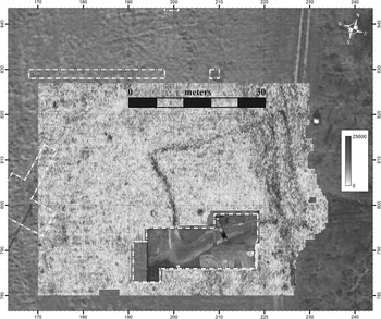
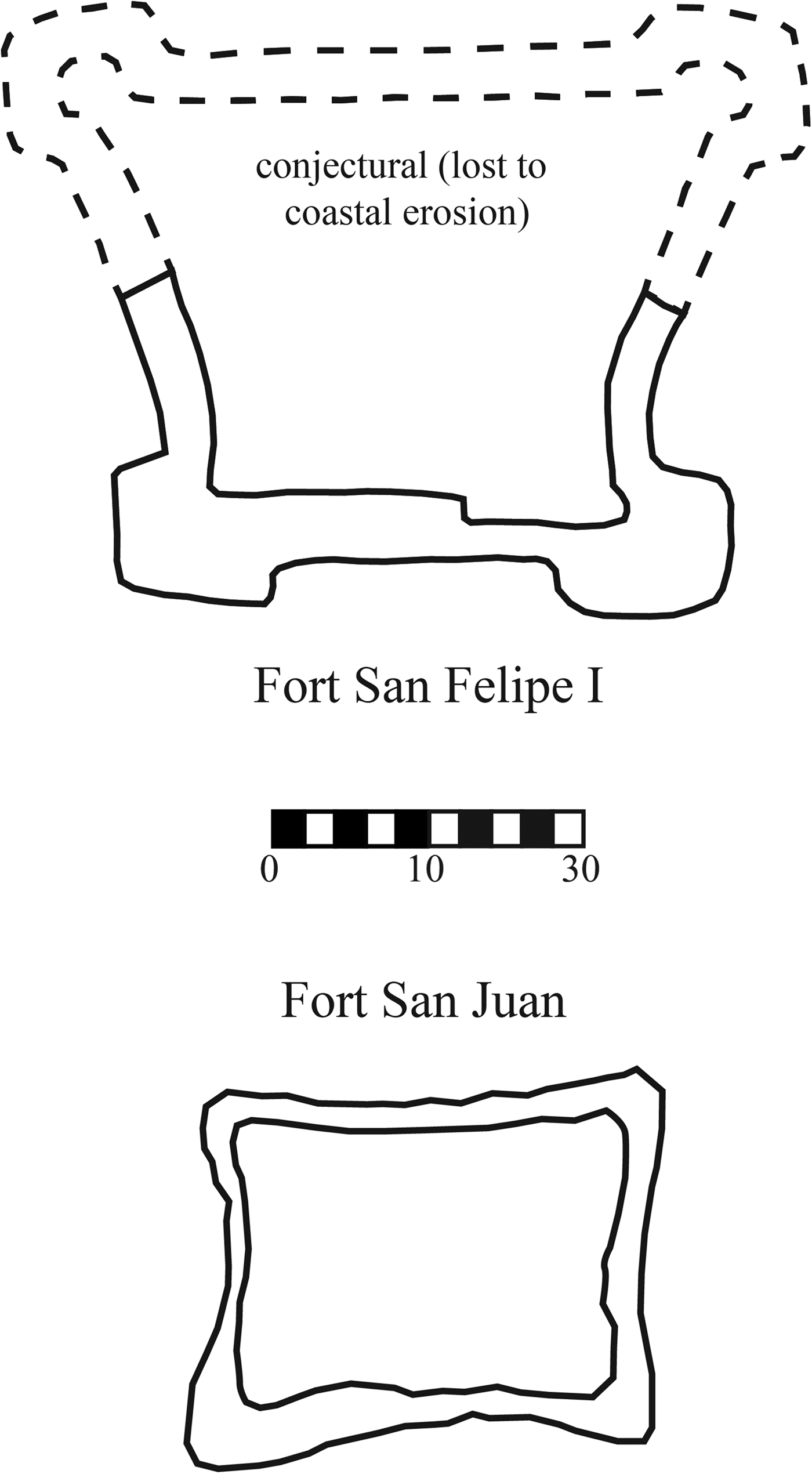
We conducted GPR survey using a GSSI SIR-3000 GPR system with a 400 MHz antenna and covered an area of approximately 2,800 m2. Traces were recorded at an interval of 0.02 m on traverses spaced 0.3 m apart. Below plow-disturbed soils, which reach a depth of 0.48 m below the surface (bs), the ditch is clearly identifiable and extends down to an average depth of 1.6 m bs, although in some places it reaches a depth of 1.8 m bs. The external dimensions of the ditch are 33 m east to west × 29 m north to south; including bastions, it encloses an area of about 490 m2 (Figure 7). While the overall shape of the ditch follows a clear plan, these results indicate that it is not symmetrical about either axis. This might reflect the haste with which it was dug, but the GPR survey reveals subsoil layers that could have presented difficulties in cutting and maintaining the eastern side of the ditch. In this area, dipping sediments that likely relate to the migration of Upper Creek might have caused profile collapse or else required recutting. In comparing Pardo's Fort San Juan with other Spanish forts of the early colonial period, its overall configuration is most similar to that of Fort San Felipe I at Santa Elena (Figure 8). This comes as little surprise, since San Felipe I was constructed by Pardo and his men in the summer of 1566, just a few months before embarking on their expedition into the interior.
Ground-penetrating radar (GPR) survey (2015) of the fort area, with 2012–2014 excavation areas indicated. GPR time slice corresponding to approximately 1.2–1.3 m below the surface. All measurements in meters.

Comparison of Fort San Juan at the Berry site with Fort San Felipe I at Santa Elena.

In the northwest section of the fort, GPR time slices reveal linear reflections between 0.6 and 0.8 m bs. Some of these probably relate to the building, Structure 7, that seems to predate the digging of the moat. At about 0.3 m bs, a discrete reflection is visible in the southern portion of the fort that continues to a depth of 1.8 m bs. It measures about 0.9 m in diameter and is almost certainly the large, circular feature designated as Feature 231 in horizontal excavation. Given its size, shape, and suggested depth—as well as the waterborne character of its associated soils—we suggest that Feature 231 is perhaps a deep well placed in the interior of Fort San Juan.
In all, we found that the GPR provided the clearest resolution of subsurface anomalies in the fort area. Each of the surveys yielded unique data, but due both to the character of the site's deep plow zone and our own use of iron nails in previous excavations around the fort, the views of the fort interior obtained by soil resistivity and gradiometry were less clear than those obtained through GPR.
Ditch Stratigraphy
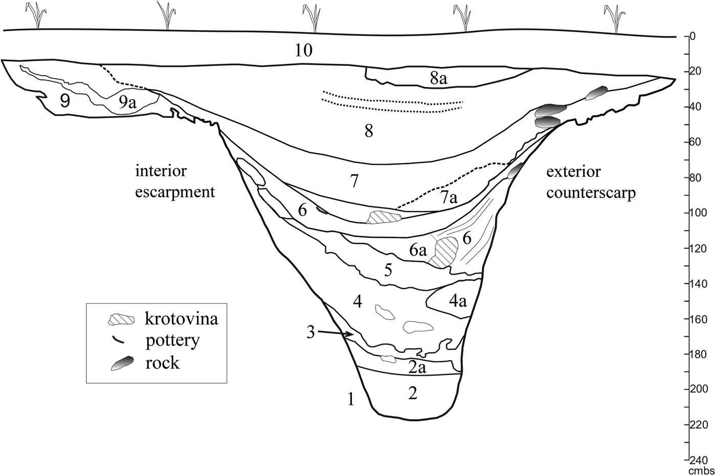
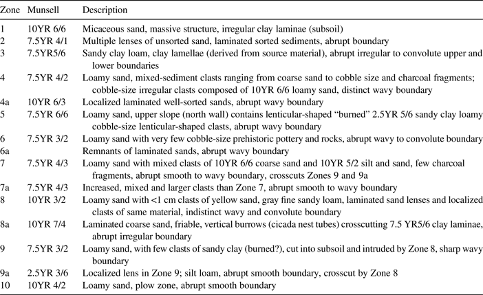
To test the authenticity and function of the ditch, Feature 224, we excavated a test trench measuring 80 cm × 4 m that cross-sectioned the ditch's southern segment (Figure 9; Table 1). Of the 4,095 L of fill, 1,575 L were water-screened; the rest was dry-screened through 0.63 cm (0.25 in) mesh. Both east and west profiles were documented, and we collected samples that include intact micromorphology blocks and systematic bulk sediments. The results of physical and chemical analyses and interpretations of these samples will be presented in more detail elsewhere. Here we summarize the stratigraphy and overall structure of the ditch, emphasizing the macrostratigraphic composition and geometry. Cross-section profiles reveal a 3.4 m wide × 2.4 m deep feature dug into the clayey sand subsoil of the floodplain. The outer counterscarp is almost vertical, while the interior wall or escarpment is sloped up to a deep bench excavated into the subsoil. This bench measures about 1 m wide × 0.3 m deep (below the plow zone) and marks the upper escarpment of the interior. It was subsequently infilled with dark organic sediment (Figure 9, Zone 9) and may have served as a bench below a glacis or was integrated into a glacis and a defensive palisade. This dark layer was crosscut by later activities in the ditch, so stratigraphic correlation is not currently possible. Sediments from inside the fort may also link directly to this zone but have yet to be explored.
Trench 2, East Profile of Feature 224 (Fort San Juan ditch).

Trench 2, East Profile of Feature 224 (Fort San Juan Ditch), Zone Field Descriptions.

The main ditch has an overall V-shape with a deep and narrow cunette (approximately 30 cm wide × 50 cm deep) at the base that is characteristic of moats and ditches that were intended to remain well drained and relatively dry. This interpretation is supported by the absence of any clay or material used to line the base of the ditch in an attempt to encourage water retention. The porous, relatively well-drained, coarse sand subsoil would have required such efforts if the ditch was designed to retain water. The hazards of standing water in the humid southeastern United States—even in the foothills of the Appalachians—would have outweighed any defensive benefits provided by a muddy moat. The preliminary geoarchaeological analysis focuses on texture and the geometry of the layers, currently observed in but two dimensions. Our observations overall suggest a ditch that was difficult to maintain due to the sandy subsoil, the original steep slopes of both the scarp and counterscarp, and the nature of the discrete infilling episodes. Most of those sediment layers that filled the ditch seem to have resulted from episodic coarse sandy sediment washing in, from the sloughing in of the walls, or from deposits tossed in by people.
Beginning at the bottom of the profile, Zones 2 and 3 form the narrow base (or cunette) and are composed of finely bedded, sorted and unsorted lenses of mixed sand and organics. Deposits such as these suggest infilling from slack water and clean sands that washed down from the inner walls of the ditch. Zone 3 caps off these laminated layers with a convoluted upper boundary that indicates soft (or in this case moist) sediment deformation.
Zones 4 and 5 originated from the fort interior and are sharply different. Their geometry and composition—mixed course clasts of sandy subsoil (up to gravel size) in Zone 4 and yellow, loamy sand matrix with clasts of unburned clay in Zone 5—suggest that these layers are derived from a source inside the fort that included pieces of subsoil. The depositional event(s) partially infilled the ditch and might have been a result of construction inside the fort. Finally, the convoluted boundary at the base of Zone 4 suggests that these relatively dry sediments were added via significant loading over wet sediment.
Zone 6 encompasses discrete depositional episodes, including sedimentation from inside and outside of the ditch, and contains localized areas of laminated sediment that suggest periodic heavy rains. The upper boundary of this group of layers consists of a disconformity that is likely the result of cleaning the ditch, though this would have left the feature with a depth of just over 1 m and with a curved basin shape that lacked the cunette. Zones 7 and 8 are more bioturbated than the underlying zones, with remnants of in situ yellow laminated sands that suggest periodic flooding, heavy rainfall, or runoff. After its final abandonment, overbank flood deposits infilled the topographic lows of the exterior portion of the ditch, designated Zone 8a. This event is visible both in the profile with coarse laminated sediments and in the aerial view at the top of the feature with the linear band of yellow sand that marks the outermost edge of the ditch. Zones 7 and 8 also crosscut the dark organic deposits, Zone 9, that overlay the aforementioned interior bench. Both Native American and European-made artifacts, including iron nails and lead shot, are distributed sparsely but consistently throughout the various zones, suggesting that this part of the ditch was not systematically used for refuse disposal during or following the abandonment of Fort San Juan. We would note, however, that further excavations in the feature may reveal areas of more focused or concentrated disposal activities.
The Defenses of La Florida and Northern New Spain
Recent discoveries at the Berry site indicate that Fort San Juan was a far more substantial undertaking than the documentary sources suggest; as such, it is important to distinguish Pardo's plan from its failure. We now turn to compare Pardo's forts with defensive systems elsewhere in La Florida and New Spain. From 1565 to 1569, Menéndez de Avilés built 10 forts or presidios on the Atlantic and Gulf coasts of La Florida, a chain that followed the coastline for more than 1,500 km from Santa Elena to the town of Tocabaga along Tampa Bay (Childers Reference Childers2004:24–25; Hoffman 1990:256, Table 2). Only four of these—San Agustín, Santa Lucia, Ais, and San Mateo (formerly the French colony of Fort Caroline)—were initially garrisoned with at least 100 soldiers. The garrisons of the other six ranged from as many as about 80 soldiers at Santa Elena (Lyon Reference Lyon1984:2) to as few as 20 at Guale (Hoffman Reference Hoffman1990:256). These six forts were staffed with an average of 39 men each, just less than double the average of 21 men that Pardo stationed at each of his interior forts. Yet, even with the tremendous advantage of being supportable by ship rather than via overland travel, most of Menéndez's coastal presidios were similarly short-lived; of his 10 forts, only San Agustín and Santa Elena managed to survive for more than three to four years, and fully half were abandoned in less than a single year (Childers Reference Childers2004:Table 1). Unfortunately, archaeologists to date have had little success identifying any of Menéndez's 10 initial presidios.
Turning to New Spain and its road to Zacatecas, Viceroy Martín Enríquez established the highway's first five presidios in 1570, some 20 years into the Chichimec War; by 1600, when the war finally came to an end, there were more than 30 (Moorhead Reference Moorhead1975:10–11). These earliest five presidios—all of which saw continuous use into the early years of the seventeenth century (e.g., Williams Reference Williams2004:Table 3)—were spaced some 30 to 80 km apart over a span of about 250 km, the distance between Zacatecas and the fortified town of San Felipe de los Reyes, situated between Zacatecas and Mexico City (Powell 1952:141–143); Pardo's forts, in contrast, were placed between 120 and 200 km apart. As with Pardo's forts, the presidios along the road to Zacatecas were earth and log constructions with no civilian populations, yet they were smaller than most of the forts that Pardo built, intended to garrison only about 5–15 men (Williams Reference Williams2004:8). Williams notes that
these soldiers were self-equipped men-at-arms who contracted their service to the king year to year. Many presidio warriors spent their time pursuing private ventures while serving in the army. Their favorite activities included prospecting and capturing Indian slaves. They often acted more like bands of hired marauders than disciplined soldiers [2004:8].
Pardo's men, too, while under the command of Moyano during their assault on the Chisca towns, took a number of Native Appalachian women as servants. Several who accompanied Pardo back to Santa Elena were later released in December 1568 (Hudson Reference Hudson1990:176). Moreover, accounts of the expeditions make it clear that soldiers stationed at Pardo's forts, particularly those garrisoned high in the Appalachian Mountains and in the western Piedmont, were likewise preoccupied with prospecting (e.g., Hudson Reference Hudson1990:156–164).
We suggest that each of these contemporaneous defensive systems required a comparable initial investment of labor and staffing and that none was inherently better planned and organized than the others. That said, comparison of the three systems reveals clear differences in relative longevity. Together these defenses include two overland networks, those of Pardo and Enríquez, and Menéndez's coastal system. Moreover, while Enríquez's overland system ultimately proved quite durable in northern New Spain, both Pardo's and Menéndez's La Florida systems were lost or abandoned in a remarkably short period of time. The problem was therefore not one of coastal versus terrestrial support, since Menéndez's coastal presidio network was hardly more successful than Pardo's interior forts. Nor were Menéndez and Pardo simply remiss or neglectful in spacing their respective garrisons too far apart. Rather, the spacing of their garrisons, and the problem of keeping them supplied, illustrates the challenge of supporting any such enterprise in sixteenth-century La Florida, whether inland or along the coast.
When Enríquez laid out his string of small presidios from San Felipe to Zacatecas, he was fortifying the road between two established points on the landscape of northern New Spain, itself a mature colonial territory for nearly five decades. This was quite unlike La Florida, which lacked any long-established colonies. Any soldiers staffing garrisons along Enríquez's network could have been supplied from San Felipe and towns south along the road to Mexico City or from Zacatecas itself, which by 1550, as noted, was the second-largest town in New Spain. Since the viceroy's garrisons were provisioned directly by the colony—their subsistence needs largely independent of local populations—their respective locations were based more on defensive needs than on the local availability of resources. Neither Pardo nor Menéndez had such luxury. Each could only hope to sustain his respective defense system both by situating forts close to Native communities and by developing alliances with indigenous leaders who could be expected to provision the neighboring Spanish garrisons. This necessity, though, put the forts at an extreme disadvantage when soldiers were forced to defend themselves against the people of their host communities, a threat not faced by the presidios of northern New Spain.
Just as important, this need created profound restrictions on the spacing of forts anywhere in La Florida. Specifically, few local town chiefs (orata) could have produced sufficient surplus to support a garrison of Spanish soldiers for any extended period. Thus it comes as little surprise that four of the six Native towns where Pardo established forts are known in the mid-sixteenth century to have been headed by regional chiefs (mico) with some authority over nearby communities and the surpluses they produced. The problem for both Pardo and Menéndez was that, in La Florida, such regional polities were usually separated by uninhabited or lightly occupied buffer zones that often extended for more than 100 km. We suggest, then, that this contingent feature of the social geography in La Florida—and not poor planning or inadequate investment—would help to explain both the wide spacing between the forts that Pardo and Menéndez established and the subsequent rapid failure of their respective defensive networks.
Conclusions
Charles Hudson, recognizing in Reference Hudson1990 how little was known of the archaeology of Pardo's entrada, suggested that
perhaps [the forts] were smaller versions of the first forts that were built at Santa Elena, [b]ut we can have no sure knowledge until one of these forts is located—if we can be so lucky—and excavated by archaeologists [1990:152].
With the recent identification of Fort San Juan de Joara, we can now confirm that this garrison was indeed similar in design to the first Fort San Felipe, built by Pardo's men at Santa Elena in 1566 (Thompson et al. Reference Thompson, DePratter and Roberts Thompson2016:182). More importantly, however, we now have a much clearer understanding of the scale of Pardo's projected road to Zacatecas. Fort San Juan seems not to have been a short-term or ephemeral construction but, rather, a substantial and well-planned installation that was built to last. And given what we know of the other installations that Pardo went on to establish between Santa Elena and the Appalachians, we should expect that these, too, were more substantial than once suspected.
Perhaps this degree of concern—and its attendant material investment—was a consequence of Spanish misconceptions about the region's social geography. That is, the perception of a clear and immediate threat from Chichimec Indians thought to be just over the mountains, on the northern frontier of New Spain, may have driven this need for stronger defense. As Menéndez's string of coastal forts was assumed to be under constant threat of French attack by sea, so too did Pardo's garrisons face continuous peril at the hands of powerful Native enemies, whether real or imagined. Again, we think that it is likely that all of these forts were substantial undertakings, and yet, as Hudson observed, we will have no sure knowledge until one of the others is found, if we can be so lucky, and excavated by archaeologists.
Fort San Juan and Cuenca were lost in 1568, yet the town of Joara persisted. In 1607, the captain of a Spanish naval expedition sailing along the mid-Atlantic coast was told of a powerful and prosperous Native American town in the mountains known as “Hoada” (Hann Reference Hann1986:10), probably a reference to the town Pardo and his men knew as Joara. Following the destruction of Fort San Juan and Cuenca, Joara reclaimed this space by burning down the structures of the domestic compound, perhaps filling in the ditch surrounding the fort, and constructing new forms of public architecture in this area. A large structure (Structure 6) was built over the southwestern corner of the fort, very clearly intruding and thus postdating the fill within the ditch. Just west of the fort is a space where one or more large marker posts were emplaced along with several burial features, one of which contained an adult male in association with a flintknapping kit and an iron knife, perhaps one of the eight knives that Pardo gave to Joara Mico in 1566 (Moore Reference Moore2002:234–237). This part of the site, then, encompasses at least one and probably several Native structures, a series of large set posts, a group of burials, and perhaps a plaza as well. We interpret these features of the built environment alongside and intruding into the former fort as an effort by the people of Joara to reclaim and revitalize the destroyed garrison as a Native space and a symbol of the persistence and vitality of the Joara community.
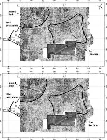
The earthen platform mound at Berry may have been an important part of this renovation and architectural revitalization. The spatial, stratigraphic, and temporal relationships among the fort, the compound, and the mound are not yet clearly known, but it currently appears most likely to us that the mound was either built in its entirety or greatly enlarged after Joara's rejection of the Spanish occupation. Evidence from Moore's 1986 excavations offer intriguing support for this possibility (Figure 10). Two sherds of olive jar and a piece of lead sprue were recovered in a partially intact humus zone overlaying mound fill on the southern edge of the mound. While this zone was forming, that part of the mound was about 1 m high (Moore Reference Moore2002:220, Figure 23), suggesting a low earthen feature similar to those that Thomas (Reference Thomas1891) described in Caldwell County in his report on the Smithsonian's Yadkin River fieldwork. If so, then most of the mound volume was added after the humus zone had formed—and thus after the olive jar sherds and lead sprue were deposited—as we know that the Berry mound eventually attained a height of at least 4 m (Thomas Reference Thomas1891:151). Although careful stratigraphic analysis is needed to resolve the temporal and spatial relationships among these cultural features, it is possible that the people of Joara used the destruction of the garrison to consolidate political authority in the upper Catawba Valley and neighboring regions, a triumph that they celebrated with the expansion of their mound into a true platform adjacent to the ruins of Fort San Juan.
Ground-penetrating radar (GPR) survey of the fort and mound area, with 1986 excavation areas indicated. GPR time slices correspond to approximately 0.6–0.7 m below the surface (bs) and 0.7–0.8 m bs. All measurements in meters.

Acknowledgments
Funding for the geophysical survey of Fort San Juan was provided by the National Geographic Society Committee on Research and Exploration. Throughout the project, Warren Wilson College has served as our local administrative host institution and supported the Archaeology Work Crew and Laboratory; we would specifically like to thank Abra Johgart for all of her work as laboratory manager for the archaeology crew. We thank the editor, Lynn Gamble, and three anonymous reviewers for comments and suggestions that significantly improved the article. Finally, we would like to thank the Berry family for their continued stewardship of the Berry site.
Data Availability Statement
All collections from the Berry site discussed here are currently curated at the Warren Wilson College Archaeology Laboratory in Swannanoa, North Carolina.