

IntroductionFootnote 1
A major problem with how scholars analyze the history of precolonial Africa stems from a lack of maps of the continent, especially in making sense of geography from an African perspective. Available maps from the slave trade period misrepresent the continent, however, since most were made from limited contemporary observations and informally gathered information. The European merchants, missionaries, and other observers who were the source for early maps frequently had no training in cartography and were restricted to what they saw or how they interpreted information they heard along the coast. There seems to have been a degree of continuity in the ethnic composition of coastal populations over time, as Paul Hair’s study of the upper and lower Guinea coasts reveals, which allows the identification of changes and shifts in the demography of population movements.Footnote 2 Further inland, it is more difficult to reconstruct political changes and migrations, but extensive research enables the identification of changes in the longue durée of the political landscape during the period of the trans-Atlantic, Saharan, and Indian Ocean slave trades. The absence of reliable cartographic data, however, has impeded historical reconstruction. As a result, some scholars of the precolonial period refer to colonial and postcolonial boundaries to locate states and the locations of ethnic groups which gives the impression that they existed in a timeless setting. This practice arose out of the necessity to establish points of reference, but poor cartography shapes our historical interpretation of Africa and its global impact.
The current emphasis in studying Africa and the slave trade focuses on a biographical approach based on database projects, such as Enslaved: People of the Historic Slave Trade (www.enslaved.org) and its partner websites.Footnote 3 These digital initiatives have the potential of addressing deficiencies in demographic reconstruction but not unless the inadequate reference to colonial and postcolonial boundaries can be overcome. Until now, much research into the slave trade has relied on coastal divisions largely derived from the observations of slave traders. Hence, Philip Curtin proposed a consciously simple schema in his influential slave trade census published in 1969, which involved the following eight coastal divisions: Senegambia, Sierra Leone, Windward Coast, Gold Coast, Bight of Benin, Bight of Biafra, West Central Africa, and Southeast Africa.Footnote 4 For fifty years, these regions have become a standard method in which to conceive of precolonial Africa, especially after their incorporation into the powerful tool Voyages: The Trans-Atlantic Slave Trade Database, which was adopted to test Curtin’s remarkable contribution in attempting to estimate the scale and direction of the forced migration of Africans to the Americas (http://slavevoyages.org/).
Curtin’s schema has proven useful in plotting where enslaved people left Africa, but critics have noted that this approach has serious weaknesses that require reflection and revision.Footnote 5 On one hand, Curtin did not cover the entire continent or delimit interior regions. On the other, he used modern-day boundaries and contemporary terms of the slave trade, such as Sierra Leone and Windward Coast, as designations for coastal regions of departure for the enslaved population.Footnote 6 Although there is no direct association between Curtin’s coastal regions and the interior from where enslaved people originated, it is still possible to interpret events in the interior as they relate to slave trade data, as Paul Lovejoy attempted in 1983.Footnote 7 Updating his analysis in three editions as more data became available, Lovejoy examined the significance of the trans-Atlantic, Saharan, and Indian Ocean slave trades from where estimated populations leaving the continent probably originated. Similarly, Gwendolyn Midlo Hall shows weaknesses in the Voyages divisions because “designations for African regions as well as for ethnicities varied among European slave traders.”Footnote 8 Grouping people according to ethnonyms recorded in historical sources has drawbacks because ethnographic generalizations may relate more to language than ethnicity. For example, the term “Lucumí” is generally equated with Yoruba in Cuba. However, this term can refer to diverse people who probably spoke the language but came from regions beyond Yorubaland.Footnote 9 Similarly, the term “Bambara” referred to an ethnolinguistic group, but by the eighteenth century took on “wider, vague, generic meanings” for diverse people brought down the Senegal and Gambia Rivers.Footnote 10 At other times, primary records use place names to distinguish ethnolinguistic groups. Hence, “Borno” appears at times as an ethnic category, when in fact it was a political state whose dominant language was Kanuri but included several distinct people and languages. Similarly, East African ethnonyms such as “Mozambiques” or “Inhambanes” provide little information other than the port from which enslaved Africans departed. Local studies of Africa and the Americas during the slave trade era (cited herein) have revised interpretations of the ethnonyms in different places, periods, and languages.
The biographic turn in the study of the global African diaspora now requires redefining the entire continent to allow for other migratory patterns not only within Africa, but also across the Indian Ocean, the Mediterranean and Red Seas, and overland via the Middle East. The present attempt to branch away from Curtin confronts problems arising from expanding datasets that require some degree of collation inclusive of, but beyond Voyages. This process requires mapping uncertain historical data involving the movements of enslaved people according to GIS techniques and practices.Footnote 11 Our continental model shares some features with the regional maps that Patrick Manning developed to project population estimates of Africa from 1650 until 1950.Footnote 12 The ongoing challenge is therefore to situate data related to the origins and destinations of people on a standardized map, which inevitably means making decisions that are political and/or ethnographic.Footnote 13 Although the laborious process of generating a series of maps illustrating temporal geographical transformations to Africa has begun, a static map of the continent with defined inland spaces is immediately required to link a network of open-source data in more meaningful ways.Footnote 14 In consideration of the politics and ethnicities of precolonial Africa, our proposed divisions attempt to follow continental ecosystems surrounding patterns in vegetation, elevation and/or sources of water.
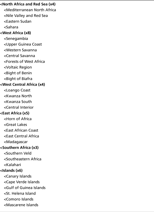
To achieve a clearer sense of the geographical structure of slavery and the slave trade, this article provides a rationale for a new regional vocabulary for precolonial Africa, which begins with Africa and then divides into the following five broad regions: 1) North Africa; 2) West Africa; 3) West Central Africa; 4) East Africa; and 5) Southern Africa. There is also a sixth group for islands. Subsequently, these divisions can then be further divided into twenty-four sub-regions and six island clusters to reflect extant historical data (Map I and Table I). While this new schema will be contentious for some, it is imperative to keep in mind that this map is purposefully designed to be expansive because in many circumstances more geographic data exist, which often refer to precolonial states, ethnolinguistic groups, territories, provinces, cities, towns, villages, municipalities, trade routes, roads, markets, buildings, vegetation, elevation, and sources of water. Depending on the type of historical evidence available, data may reside in more than one of the proposed sub-regions.
Map 1. Proposed African Regions

Flowchart of Controlled Vocabularies of African Regions

Historiography of African Regions
Before justifying our divisions, it is necessary to point out that “region” has multiple meanings. The Oxford English Dictionary defines it as “a sub-division of the earth” or “any area, space, or place of more or less definite extent or character.”Footnote 15 Accordingly, regional boundaries overlap, which creates practical difficulties in mapping because it is impossible to establish perfect borders which everyone could agree upon. In practice, however, GIS software demands fixed polygons in which to position data. The contradiction of having to establish firm lines for large and ambiguous areas raises questions related to how to delimit a region and how much regions change over time.
The practice of grouping slave trade data into regions has been a methodological procedure that has been pursued effectively for a long time. Curtin defined his regions as:
The first of these is the conventional Senegambia, little changed from the sixteenth century and including the present-day Gambia and Senegal. A second region can be labelled Sierra Leone, but it would take in a good deal more than the present country. Instead, it would extend from the Casamance in the north to Cape Mount in the south, including the coastlines of Guinea-Conakry, Guinea-Bissau, and a very small part of Senegal and Liberia as well.
The third region would be the line of open breakers along the east-west coast from Cape Mount to Assini – mainly the present day Ivory Coast and Liberia. The eighteenth-century English called it “Windward Coast,” a term sometimes used for the area on the other side of Sierra Leone. A fourth region, the Gold Coast, presents no serious problem. In English usage at least, it has remained stable over several centuries as the coastal stretch from Assini on the west to the Volta in the east, roughly coterminous with the present-day Republic of Ghana. Here the Europeans build the greatest concentration of fortifications anywhere on the African coast – drawn by the gold trade to the interior and the existence of a series of rocky points with moderately safe landing beaches on the lee side, or by an occasional lagoon or river mouth where lighters could load or unload in security.
Further east, coastal terminology is less stable over time, with terms like “oil rivers” or “the slave coast” used at some periods but not at all. A fifth division, however, can be seen in the geographic Bight of Benin, taken here to include everything from the Volta to the Benin River. The core of this region in the eighteenth century was the somewhat narrower “slave coast” of present-day Togo and Dahomey. In the same way, the Bight of Biafra can be taken as a sixth region, centered on the Niger Delta and the mouth of the Cross and Duala rivers to the east. Its bounds were the Benin River on the west and Cape Lopez to the south, in present-day Gabon. Then, from Cape Lopez south to the Orange River a number of different trading regions existed in fact, but the data are not sufficient to distinguish among them. The term Central Africa will therefore be used here as a seventh unit, through the term “Angola” in its broadest sense had the same meaning. Finally, the eighth region is the coast of southeastern Africa, from the Cape of Good Hope to Cape Delgado and including the island of Madagascar. In fact, few slaves were ever sold from the coast south of the present-day country of Mozambique, and the term Mozambique was sometimes used for the whole region.Footnote 16
These divisions were needed to attach slave ship departure data from Africa to produce regional estimates of the number of people transported across the Atlantic. This coastal distribution inferred inland spaces, incorporated European terms and used modern-day boundaries.
The Voyages database contains nearly 36,000 individual ships leaving Africa projected onto nine comparable regions that Curtin established in 1969. They are: Senegambia and Offshore Atlantic, Sierra Leone, Windward Coast, Gold Coast, Bight of Benin, Bight of Biafra and Gulf of Guinea Islands, West Central Africa and St. Helena, Southeast Africa and Indian Ocean Islands and “Other Africa.”Footnote 17 As defined in Voyages:
Senegambia is anywhere north of the Rio Nunez. Sierra Leone comprises the Rio Nunez to just west of Cape Mount inclusive. The Windward Coast is defined as Cape Mount up to and including the Assini River. The Gold Coast runs east of here up to and including the Volta River. The Bight of Benin covers the Rio Volta to Rio Nun, and the Bight of Biafra, east of the Nun to Cape Lopez inclusive. West-central Africa is defined as the rest of the western coast of the continent south of this point, and South-east Africa anywhere east of the Cape of Good Hope.Footnote 18
Clearly, the continued use of Curtin’s terminology is persistently awkward despite allowing for regional overlap. In Curtin’s census there is no discussion of how European maps about Africa were abstractions. As a result, many of the maps we continue to rely on have “sought to engulf African space into the symbolic system of western European representation. The map was therefore an indispensable instrument of territorial appropriation, organization, management, and then exploration.”Footnote 19 Additionally, the main unit of analysis is the slaving voyage, not the people whose inland origins can sometimes be determined. Ethnonyms documented by slave traders and owners oftentimes referred to languages that can be associated with regions and/or ports of embarkation.
We fully recognize how much Curtin and Voyages revolutionized the field of African and African diaspora studies. Their regions have been accepted as a standard means to understand when and where people boarded slave ships at 180 principal places of slave purchase (Appendix I). Nevertheless, more and more data are being amassed that connect the global slave trade, especially in terms of the movement of people inland and where they traveled in the world. These new datasets, which oftentimes align well with Voyages, will certainly bring further insight into the geographic distribution for Africa especially as more data is generated for a continental historical GIS project.Footnote 20
Proposed Regions and Sub-Regions
Building upon Curtin and Voyages, we have modified the divisions in six key ways: 1) regionalizing the entire continent; 2) using terms that reference geographical features; 3) adjusting coastal start and endpoints; 4) establishing inland territories based on continental ecosystems; 5) sub-dividing larger areas; and 6) separating offshore islands. The remainder of this article explains the five regions and twenty-four sub-regions, as well as six island groupings.
Region 1
North Africa and Red Sea consists of the northern-most territories of the continent along the shores of the Atlantic, Mediterranean and Red Sea. It includes the modern nation-states of Ethiopia, Sudan, Eritrea, Egypt, Libya, Tunisia, Algeria, Morocco, Western Sahara, Mauritania, and parts of countries that stretch into the Sahara, such as, Mali, Niger, and Chad.
Mediterranean North Africa includes sections of the former Egyptian, Roman, Ottoman and Almoravid provinces along the continental coast of the Mediterranean. It extends a few hundred kilometers inland where larger populations of people reside. It includes the Mahgreb and Atlas Mountain range, but not the Nile delta, Nile valley and oases to the south. The coastline stretches from Agadir in Morocco to Egypt, not including the Nile delta. Berbers and Arabs are the dominant ethnolinguistic groups in this area.Footnote 21
Nile Valley and Red Sea comprises several circuits of exchange from major slave supplying areas. The Ottomans drew upon the Nile valley, Ethiopia and the savanna west of the confluence of the White and Blue Nile as far as Darfur and Wadai, as well as the Ethiopian highlands and lowlands along the Red Sea. Slaves from these supplying areas, including Oromo, Sidama, Käfa, Magi, Gamu, Gimira, Gofa, Wälaytta, Kullo and Konta, were found in Zeyla, Berbera, Tajura, Massawa, Sawakin (and from there shipped to Arabia, the eastern Mediterranean, the Persian Gulf, Iran, and South Asia). This sub-region includes Silwa, Faiyum, Bahariya, Farafra, Dakhla, Kharga, and al Atrun, as well as the Afar depression. It amalgamates the north/south trade routes along the Red Sea, the Sahara crossings, and the Nile valley, but also the east/west trade to the Eastern Savanna sub-region.Footnote 22
Eastern Savanna incorporates Wadai, Darfur and Kordofan west of the Nile valley and includes the region of the Sudd and the sources of the northern tributaries of the Congo River basin. The region corresponds includes the western part of modern Sudan, the Republic of South Sudan, much of Chad and the Central African Republic. Besides the inhabitants of Wadai and Darfur, it included nomadic Arabs as well as Sara, Dinka, Nuer, and Shilluk.Footnote 23
Sahara encompasses the planet’s largest desert, which extends to the Atlantic in the west from the Atlas Mountains to the Senegal River and the Nile River in the east. This arid ecosystem had sparse populations, including people who had been enslaved further south, and significant trade routes.
Region 2
West Africa incorporates much of Curtin’s coastal distribution for aggregating trans-Atlantic slave trade data from the Senegal River southward to the Bight of Biafra. It involves the countries of Senegal, The Gambia, Guinea-Bissau, Guinea, Sierra Leone, Liberia, Côte d’Ivoire, Ghana, Burkina Faso, Togo, Benin, Nigeria, Cameroon, Equatorial Guinea, and Gabon, and parts of Mali and Niger.
Senegambia sub-region incorporates the basins of the Senegal and Gambia Rivers, including the source of those rivers in the Fuuta Jalon highlands. In some ways, the sub-region is an extension of the western savanna region to the coast and included major sources of gold in the Senegal River valley. The area was largely Muslim and historically witnessed the earliest jihads in West Africa that began in the late seventeenth century and continued throughout the eighteenth and nineteenth centuries. The key ethnonyms include Wolof (Jolof), Serer, Mandinka, Susu, Bambara, and Fulbe (Fula, Peul).Footnote 24 The enslaved were mostly embarked at St. Louis, Gorée, and the Gambia River.
Upper Guinea Coast incorporates the coast to the south of the Casamance River as far as Cape Mesurado. This sub-region was bounded in the east by the Fuuta Jalon highlands along the many rivers that originate there. The sub-region broadens into the interior south of the highlands. The coastal boundaries extend from the south of the Casamance to Cape Mesurado. This area is distinguished from Senegambia because of lower elevation and heavier rains, which give this region a distinctive riverine ecosystem that includes mangrove swamps where rice cultivation predominated and whose southern interior provided kola nuts for shipment into the savanna.Footnote 25 The ethnolinguistic groups included Diola (Jola), Balanta, Papel, Brame, Bijago, Biafada, Nalu, Baga, Susu, Temne, Bullom, Mende, and Vai.Footnote 26 In historical sources, the ethnonym “Guiné” often indicated origins from either Senegambia or the Upper Guinea Coast. The enslaved departed from Bissau, Cacheo, Rio Nunez, Rio Pongo, Îles de Los, Bunce Island in the Sierra Leone River, Sherbro Island, and the Gallinhas.
Western Savanna corresponds to an inland section of the sahel and savanna east of the Senegal River basin toward the source of the Volta River below the great inland bend in the Niger River near Timbuktu. Historically known as the western Sudan, we avoid the use of “Sudan” to prevent confusion with modern countries. The bulk of this territory was formerly the center of Mali, which was later incorporated into Songhay.Footnote 27 After the collapse of Songhay in the 1590s, the region was dominated by smaller states, especially the Bambara states of Segu and Kaarta, until the jihad movement overthrew these states in the nineteenth century. In the Americas enslaved people from this region were identified as Mandingo or Mandinga, that is, Mandinka, although others were often referred to as Bambara (Bamana) who were not considered to be Muslims but who spoke the same language.
Central Savanna includes the savanna and sahel downstream from the great bend in the Niger River south of Timbuktu to the confluence with Benue River and eastward to the Lake Chad basin.Footnote 28 This area of sahel and savanna was known as the Central Sudan. It includes the heart of the Songhay Empire, the various Hausa states (which were consolidated into the Sokoto Caliphate after 1804), Borgu, Nupe, Kanem-Borno, the Jos Plateau, and areas in between. The most numerous languages were Hausa and the Kanuri of Borno, but also included numerous other ethnic groups, including Nupe, Gwari, and various groups in the Jos Plateau.
Forests of West Africa is the term used here to refer to the area that comprises much of modern-day Liberia and Cote d’Ivoire. In slave trading terms, this region was known as the Windward Coast because it was to the windward of the Gold Coast and the Bight of Benin, but it was also variously known as the Ivory Coast, Grain Coast, and Kru Coast. The proposed coastal boundaries in our schema stretch from Cape Mesurado to the Bandama River as far as Grand Bassam. The northern boundary is the southern fringes of the savanna. The distinctive feature of this region is the forest, which was a principal source of kola nuts that were traded northward. Key ethnonyms include Kru, Kissi, Gouro, Bete, and others who were sometimes known in the Americas as Gangá.Footnote 29
Voltaic Region extends from Grand Bassam in the west to the Volta River and northward to the headwaters of the White and Black Volta Rivers and includes what often is referred to as Gold Coast. It includes the gold deposits and kola producing areas. In the early eighteenth century, the Asante kingdom emerged as the dominant state in this region and controlled most of the slave trade via European forts at Elmina, Cape Coast, Anomabu, Koromantyn, Christianborg, and more than a dozen other fortified castles.Footnote 30 The main ethnic group was Akan, including Asante, Akwamu, and Fante, as well as Ewe. In the Americas, the enslaved were often referred to as Cormanti or Mina.
Bight of Benin, often referred to as the Slave Coast in contemporary European sources, extends from the Volta River eastward to the western Niger River delta and was bounded in the west by the Atakora Mountains and in the east by the Niger River below the confluence with the Benue River. The northern boundary shades into the central savanna.Footnote 31 From the middle of the seventeenth century until its collapse in 1817–1836, the principal state was Oyo, which included parts of Nupe and Borgu as well as much of Yorubaland. The key ethnonyms include Yoruba, who were referred to as Lucumí in Cuba, Nago in Brazil, Aku in Sierra Leone, as well as Allada, often referred to as Arará or Jeje in the Americas, Mina, Mahi, and other Gbe language speakers. The Edo-speaking Benin Kingdom was in this sub-region. The most important slave port was at Ouidah, but other places on the lagoon system behind the coast were also departure points, from Little Popo in the west to Lagos in the east.
Bight of Biafra incorporates the interior of the central and eastern Niger Delta and the Cross River but extends southward to the Gabon estuary. In terms of the trans-Atlantic slave trade, Igbo and Ibibio supplied most of the enslaved, who were known in the Americas as Carabali. Other ethnonyms referred to Efik, Ijaw, Fang, and various people on the interior grasslands north of Mount Cameroon.Footnote 32 The two main slave ports were Bonny in the Niger Delta and Calabar on the Cross River.
Region 3
West Central Africa includes Angola and both the Republic of Congo and the Democratic Republic of the Congo, extending northward to the Central African Republic, southern Gabon and eastward to Zambia. Nearly half of all enslaved people in the trans-Atlantic slave trade, or approximately 5.7 million people, were put on board slave ships at places of embarkation between the Gabon estuary and ports north of the Kalahari. The region is predominately Bantu in terms of linguistic identification and has often been called West Central Africa. It is divided into four sub-regions: the Loango Coast, to the north of the Congo River, and two sub-regions to the south of Congo River, Kwanza North and Kwanza South, and, finally, a Central Interior region further inland from the coast. The Kwango, Kasai, and Kubango rivers were inland boundaries.Footnote 33 While the Kingdom of Kongo was clearly a unified state, there were the states of Ndongo, Matamba, Kassanje, and smaller ones north of the Kwanza river. People there spoke Kimbundu, but the degree of cultural and linguistic unity is unclear. The Kwanza South region was characterized by small polities and decentralized groups, such as Kisama or Ndombe. Ovimbundu did not emerge as a term and identity until the end of the nineteenth century.Footnote 34 In most historical data, “Congo” and “Angola” were common, but these designations suggest nothing more than an individual originated somewhere in the broader region and must be treated as such. Due to a vast array of other ethnonyms associated with the region, however, dividing this region into four parts is worthwhile. The broader area covers Angola and both the Republic of Congo and the Democratic Republic of the Congo, extending northward to the Central African Republic, southern Gabon and eastward to Zambia.
Loango Coast incorporates the region between Cape Lopez at the Gabon estuary to Cabinda, north of the Congo River. It refers to the Mayombe region, characterized by dense jungle and the northern tributaries of the Congo River, including the Loango Kingdom, Kakongo, and Ngoyo.Footnote 35 Ethnonyms included: Ngoyo, Kakongo, Mboma, Muburi, and Teke.
Kwanza North extends from the Congo River, its southern tributaries and the Kwanza River to the Dande River basin and historically included the Kingdom of Kongo and the port of Ambriz.Footnote 36 Designations include Kongo, Yaka, and Ndembu, and south of the Dande River, Ndongo, Matamba, and Kassanje. The major port, Luanda, was located on the southern frontier of the Kongo kingdom, which was a unified state. Other states include Ndongo, Matamba, Kassanje, among other smaller ones. On the Kwanza North, people spoke Kikongo and Kimbundu, but the degree of cultural and linguistic unity is unclear. Other ethnonyms were Angola, Njinga, Libolo, Kasanje, Kalandula, Songo, Kisama, and Dongo.Footnote 37
Kwanza South indicates the territory between the Kwanza River and the town of Namibe, formerly Moçamedes, on the northern fringes of the Kalahari. Kisama people, who were organized into smaller political units and decentralized societies, operated as a buffer zone between Kwanza North and South because they resided on both sides of the river in the seventeenth century.Footnote 38 The main port was Benguela. Before the eighteenth century, smaller polities prevailed, such as Kakonda. By the early eighteenth century, centralized and militarized states started to consolidate, such as Wambu, Bihe, and Mbailundu. Inland populations were organized into chieftaincies, such as Kakonda, and in highlands, Wambu, Bihe, and Mbailundu. Most of the population spoke Bantu languages, although sources also refer to Khoe and Kung groups in the southern part of the regions (referred as Mocorocas, Mocoando, and Mucuancalas, in Portuguese sources). Ovimbundu emerged as an identity by the end of the nineteenth century.Footnote 39 Key ethnonyms were: Benguela, Ndombe (Mundombe), Kakonda, Kilengues, Bihe (Viye), Mbailundu, Nano, Hanya, Kingolo, Kitata, Kisange (Kinsanji), Kipeyo (Cipeio), Fende, Nganguela (Ganguela), Wambu (Huambo), Ciyaka, and Sokoval.
The Central Interior is a landlocked area for which there is scarce written evidence. The boundaries in the north overlap with sub-regions of the Nile Valley and Red Sea, Eastern Savanna, and Central Savanna. To the west, we use the Kwango, Kasai, and Kubango rivers as inland boundary markers with the Bight of Biafra, Congo North, Kwanza North, and Kwanza South. In the east it extends to the Great Lakes and East Central Africa and to the south to Southern Africa (see below). There is not much evidence of people from this deep inland region reaching either the east or west coasts of Africa during the era of the transoceanic slave trades.
Region 4
East Africa connects to the Indian Ocean world. However, the southeastern part of this region also tied into the trans-Atlantic slave trade and is reflected in Voyages data.Footnote 40 It relates to the modern-day countries of South Sudan, Somalia (including virtually independent Somaliland), Kenya, Uganda, Rwanda, Burundi, Tanzania, Malawi, Madagascar, and Djibouti, as well as parts of Ethiopia, the Democratic Republic of Congo, Zambia, and Mozambique. The coastal belt begins approximately at the Bab-el-Mandeb Strait in the Horn and stretches to the Zambezi.
Horn of Africa reflects the Somali desert and environs. It is bordered inland by the Ethiopian highlands and Rift Valley. Its sparse population was primarily Somali.
Great Lakes form around the large lakes of Turkana, Kyoga, Albert, Edward, Victoria, Kivu, Tanganyika, Rukwa, and Mweru, but not Lake Malawi (which is in East Central Africa). Abdul Sheriff uses the approximate area between the Lomami and Lualaba rivers as the western boundary marker with the Central Interior. This region was a source of enslaved people for the Nile Valley sub-region.Footnote 41 Most enslaved people from the Great Lakes were brought to the coast opposite Zanzibar. Some ethnonyms from this large sub-region include Baganda, Banyoro, Manyema, and Nyamwezi.
East African Coast, or Swahili coast, is a relatively thin strip of territory stretching from Mogadishu along the Shabelle River and extending to the Rufiji River and Mafia Island to the south of Zanzibar. It extends no more than about 200 kilometers inland beyond which there is very low population density except in highland areas. It includes numerous trading towns that did not develop strong territorial empires but rather participated in the cyclical monsoons of the trans-Indian Ocean trade.Footnote 42 Important ethnonyms for this sub-region include Zigua/Zigula, Zaramo, Nyika, and Somali, and ports of departure such as Mombasa.
East Central Africa lies between the Rufiji and Zambezi Rivers, including the Kilwa Coast. Inland boundaries run along the Rufiji River to the Luwegu confluence, after which it extends westward along the southern shores of Lake Tanganyika and Lake Mweru and then the Luapula river southward until Zumbo. It includes Lake Nyasa (Malawi) and the Zambezi valley. For the most part captives boarded slave ships through Kilwa, Mozambique Island, Angoche, and Quelimane (the latter mostly for the Brazil trade in the early decades of the nineteenth century).Footnote 43 The most important ethnonyms were: Yao (Mujao, Mujana, Mujava), Makua/Macua, Makonde/Maconde, Bisa, Ngindo, Nyasa/Nyanja, Manganja, and Sena; and it was the location of many Portuguese land grants that have been referred to as prazos.Footnote 44
Madagascar was both a source and destination for enslaved captives of diverse cultures.Footnote 45 It is grouped into East Africa due to the nature of trade between the large island, the eastern continent and Indian Ocean world.
Region 5
Southern Africa forms the continental cone. It begins at the northern Kalahari around the Cape of Good Hope until the Zambezi River. It relates to Namibia, Botswana, Swaziland, Lesotho, South Africa, Zimbabwe, as well as parts of Angola, Zambia, and Mozambique. The region is divided into Southern Veld, Southeastern Africa, and the Kalahari. Except for Cape Town and around Maputo Bay, most of the coast is sparsely populated until Inhambane, which sent captives to both the Mascarene Islands and the Americas in the late eighteenth and early nineteenth centuries.Footnote 46 The Kalahari and Namib deserts had low populations.
Southern Veld extends from the Cape of Good Hope, along the coast and inland into the grasslands to the east of the Kalahari to the inland portion of the Zambezi basin. Major ethnolinguistic groups included the descendants of Dutch and other European settlers at Cape Town and environs, known collectively as Boers, as well Xhosa, Sotho, Swazi, Setswana, Bemba, Nyanja, Tonga, and Lozi. The region affected the mfecane wars of the nineteenth century and the Great Trek of the Boers into the interior, especially after 1834.
Southeastern Africa refers to the coastal belt from the north of the lower Zambezi basin and south to Maputo Bay, formerly known as Delagoa Bay. The people who inhabited this area included: Sena, Tsonga, Ndau, and the location of many prazos.
Kalahari, along with the Namib Desert, had low populations, hunters and gatherers and cattle herders living on the margins of the deserts.
Islands
Canary Islands are an archipelago. The main islands are Tenerife, Fuerteventura, Gran Canaria, Lanzarote, La Palma, La Gomera, El Hierro, among other smaller islands and islets. Cape Verde Islands can be divided into two groups, the Barlavento Islands or windward islands which include Santo Antão, São Vicente, Santa Luzia, São Nicolau, Sal, and Boa Vista; and the Sotavento Islands or Leeward Islands, which are Maio, Santiago, Fogo, and Brava. The islands had ties with both Senegambia and the Upper Guinea Coast through Bissau and Cacheu. Gulf of Guinea Islands had connections with the Gold Coast, Bight of Benin, Bight of Biafra and West Central Africa. Fernando Po (now Bioko), São Tomé, and Príncipe form the main island chain as part of a line of volcanoes emerging in the ocean offshore from modern-day Cameroon. In the southern Atlantic, St. Helena historically had connections with places in West Central and Southern Africa, especially after 1807 following the British abolition of the Atlantic slave trade.Footnote 47 The Comoro Islands, consisting of Grande Comore (Ngazidja), Anjouan (Ndzuwani or Nzwani), Mohéli (Mwali), and Mayotte (Maore or Mahori), are located in the Mozambique Channel between Madagascar and the the continent, which means these islands have always been connected to the entire region both as a destination and departure point for enslaved people. Likewise, the Seychelles archipelago contains over 100 islands, the most significant being Mahé, Praslin, and La Digue. Finally, the Mascarene Islands of Réunion, Mauritius, and Rodrigues were variously occupied by different European powers and significant in the East India trade. A slave trade went to the islands, especially in the eighteenth and nineteenth centuries.Footnote 48
Conclusion
This article has proposed a new schema for the regional division of the entire continent of Africa and its offshore islands for the purpose of aggregating data for demographic analysis. Our intention is to establish best practices in assembling large datasets of historical documentation that avoid problems of distinguishing among ethnonyms and languages. We do not propose that Voyages and other projects should abandon existing methods of organization, but we do attempt to provide an alternate approach to the Curtin schema for recognizing regions as units of analysis. The controlled vocabulary divides Africa into five broad regions composed of a total of twenty-four sub-regions plus the island clusters. While these geographic territories may be debatable for certain purposes of historical reconstruction and may be far from perfect even for data analysis, a schema is nonetheless required in order to advance the study of Africa and the African diasporas that can benefit from advancements and new methods in digital humanities and biographical data with more granular specificity. Our aim has been to build on the historiography, which begins with Curtin’s ground-breaking 1969 census, later adopted by Eltis and the numerous contributors of Voyages. That regionalizing must be revised for digital projects that are currently being developed in relation to biographies of enslaved Africans. Our proposed regions and sub-regions cover the whole continent and nearby islands, not just the coast, to facilitate the analysis of complex inland and external migrations and to avoid projecting twentieth-century ethnic identifications into earlier periods.
Efforts to determine the origins of the enslaved population leaving Africa and indeed remaining within Africa have received a new impetus through the collection of biographical information, especially by organizing databases about Africans who were enslaved from the sixteenth through the nineteenth centuries. Patterns can be discerned that suggest a schema for identifying the broad if necessarily fuzzy regions from where enslaved people came. Until now efforts to establish the origins of the enslaved population have been based on modern political and/or ethnic boundaries which have changed over time. The biographical data make it clear that it is not necessary to relate the backgrounds of enslaved people through references to modern countries which distort our understanding of the past. The data collection related to when and where people came from in precolonial Africa and when and where they went, whether in terms of continental, transcontinental, or transoceanic slave trades, makes it necessary to define regions and boundaries that have a greater degree of historical context than has previously been the case.
Henry B. Lovejoy, Assistant Professor, University of Colorado Boulder, hlovejoy@colorado.edu
Paul E. Lovejoy, Distinguished Research Professor, York University, plovejoy@yorku.ca
Walter Hawthorne, Professor, Michigan State University, walterh@msu.edu
Edward A. Alpers, Professor Emeritus, UCLA, alpers@history.ucla.edu
Mariana Candido, Associate Professor, University of Notre Dame, mcandido@nd.edu
Matthew S. Hopper, Professor, California Polytechnic State University, mshopper@calpoly.edu
Appendix 1
Comparison of Voyages “Regions” and data for “Principal Place of Slave Purchase” with proposed Regions for “West Central Africa,” “East Africa,” and “Southern Africa” with data for “Principal Place of Slave Purchase”