GLOUCESTERSHIRE
(1) Ashchurch, land south of A46 (SO 9365 3340): an excavation revealed activity at the site between the late second and early fourth centuries a.d. In the northern portion of the site this consisted of a ‘T’-shaped corn-drier, the fill of which provided evidence of crop processing in the late Roman period. A series of ditches encircling the corn-drier are believed to be a multi-phase enclosure demarcating a designated area for industrial activity. Three boundary ditches crossing the site, one oriented north to south and the other two running parallel east to west, corresponded to linear features identified during a prior geophysical survey. The eastern end of the southernmost of the ditches contained high concentrations of charcoal which was shown to have been ‘raked’ into the ditch from the north where the corn-drier is situated. A small number of contemporary refuse pits and a well were also revealed.Footnote 74
(2) Gloucester, Block M, Gloscat Redevelopment Project (SO 8327 1831): an excavation adjacent to the Roman cemetery identified at the Gloscat Media Studies site revealed occupation evidence. Early Roman features including enclosures, a kiln and a possible domestic dwelling were found, along with 43 mid to late Roman burials. Late Roman activity was represented by ditches on a gridded alignment, a stone structure and a possible sunken building.Footnote 75
(3) Lydney, land east of Lydney (SO 6436 0361): an excavation identified at least two phases of Roman activity. The first phase included drainage and enclosure ditches, pits, post-holes and a possible crop-processing oven, all dating to the first to second century a.d. Later features included a late second- to fourth-century agricultural or industrial complex with associated domestic activity, including four masonry structures, a well, ditches and pits. A cremation grave also dates to this period. Evidence for terracing of the land prior to construction of the buildings was identified and field boundary ditches, trackways and isolated refuse pits were also present.Footnote 76
(4) Shurdington, Farm Lane (SO 9357 1945): an excavation and watching-brief carried out over an area of 13.9 ha uncovered the remains of a farming settlement which was established during the later Iron Age and continued in use until the middle Roman period. The settlement initially comprised a roundhouse within a curvilinear enclosure near the north-eastern limit of the site, with smaller probable stock enclosures a short distance to the south-west. Activity continued at the enclosure in the early Roman period, when it was replaced by a sub-rectangular enclosure in the same location, which was subsequently remodelled before it was eventually abandoned in the middle Roman period. During the Roman period large rectilinear enclosures were constructed across much of the site, representing the expansion of agricultural activity associated with the settlement. A particular focus of settlement and small-scale industrial activity was represented by part of a large sub-rectangular enclosure which may have originated in the early Roman period and continued to develop into the middle Roman period. This enclosure was associated with a rectangular timber building, an oven, a stone-lined rectangular pit and rubbish pits. A concentration of metal small finds, mainly personal items, and worked stone objects (suggesting grain processing) was found in the vicinity. The recovery of part of at least one millstone suggests there was a mill nearby. A sub-rectangular enclosure in the north-western part of the site had a funerary function and was associated with three inhumation graves and two cremation burials, as well as two pottery vessels which had been deliberately buried in shallow pits.Footnote 77
SOMERSET
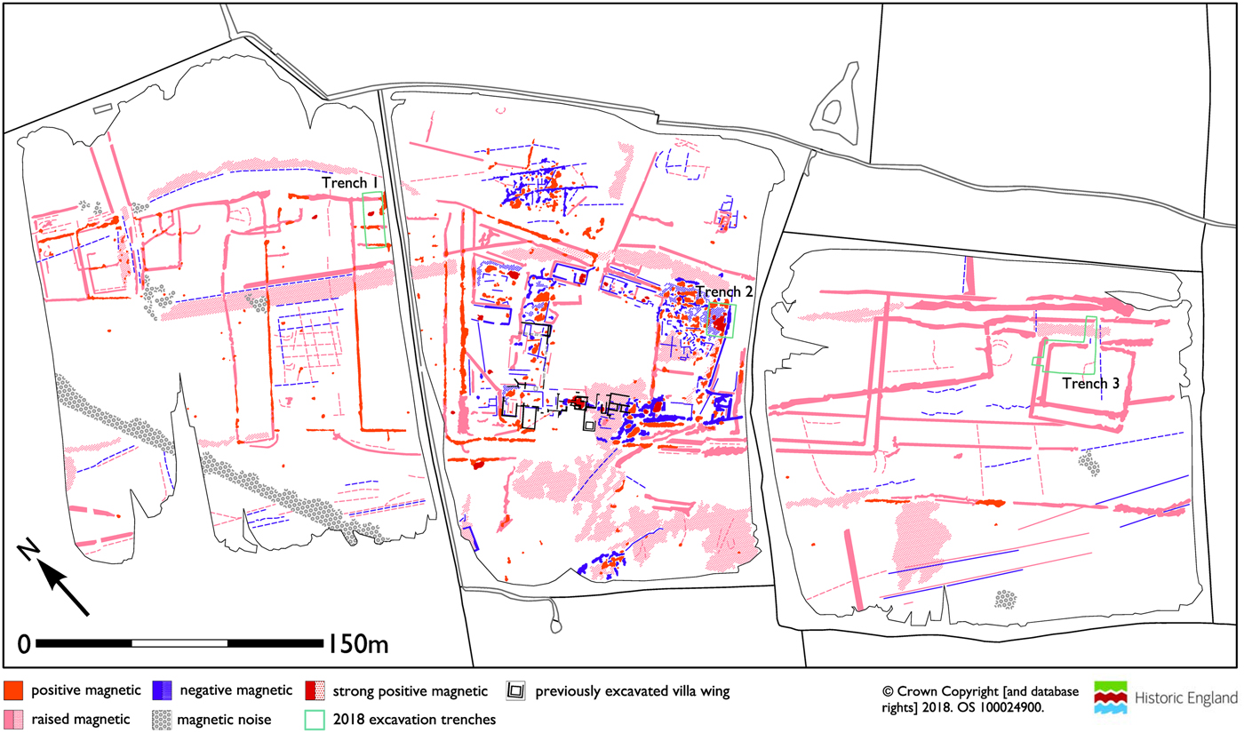
(1) High Ham, Low Ham Roman villa (ST 4364 2887): caesium magnetometer and Ground Penetrating Radar (GPR) surveys investigated the extent and state of preservation of the scheduled villa site (NHL No. 1006192) and its environs. Beyond the villa site the magnetometer survey mapped a wider system of associated trackways and enclosures, whilst the GPR coverage (6.9 ha) revealed extensive ranges of buildings arranged around a central courtyard contained within a sub-rectangular enclosure defined by double ditches with a north-east-facing access corridor (fig. 29).Footnote 78 Subsequent evaluation took the form of three excavation trenches. One trench, north of the villa, revealed a succession of enclosure ditches, a large flue and an area of rubble with little underlying structural evidence. The flue incorporated worked stone which may have derived from the main villa. A second trench evaluated the villa buildings in the newly discovered south-east wing beyond the scheduled area. This revealed a complex sequence of late Roman industrial activity and structural redevelopment of the villa buildings. Quantities of industrial debris were found, particularly in association with a hearth and pits, alongside disturbed tesserae and pottery, iron and animal bone. A third trench targeted a quadrant of a large rectilinear enclosure south of the villa that lay alongside a trackway. This revealed that the enclosure succeeded at least two roundhouses of different construction styles, with another roundhouse not stratigraphically related. The enclosure ditch proved to be large, deep and repeatedly recut; it was elaborated to the exterior with additional boundary features including a small V-shaped ditch and post-holes, possibly cut through a bank. Both Iron Age and Roman pottery were found in this part of the site.Footnote 79
Low Ham Roman villa: magnetometer survey and excavation results. The villa complex lies in the centre of the three fields. The villa buildings surround a courtyard which shows as a largely undisturbed square on the plan.

DEVON
(1) Ipplepen, Dainton Elms Cross (SX 8400 6600): open area excavation explored the southern part of the site c. 160 m east of the 2017 trenches.Footnote 80 Parts of three ditched enclosures, first identified through geophysics, were exposed revealing occupation extending from the middle–late Iron Age through to the fourth century a.d. Features included several roundhouse gullies, three wells and a cluster of east–west-oriented inhumations c. 150 m south of the cemetery of at least three rows of east–west-orientated graves excavated in 2014–15.Footnote 81 A stratigraphically later grave, on a slightly different orientation, produced a radiocarbon date of cal. a.d. 434–650. A large assemblage of domestic rubbish included the site’s first animal bone assemblage (the background acidity of the soil having apparently been neutralised by the density of occupation).Footnote 82
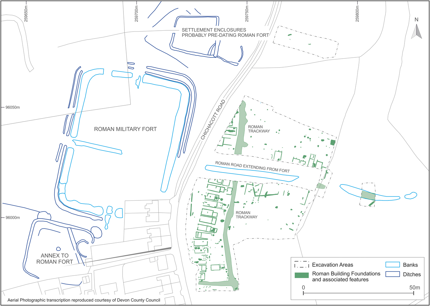
(2) Okehampton, Romansfield, Crediton Road (SX 5991 9610): excavations revealed the post-trenches and post-holes for at least 25 timber buildings outside the scheduled Roman fort of Okehampton (NHL 1015829). The buildings were arranged on either side of a well-preserved road approaching the fort’s east gate and alongside a metalled track running at right angles to the road (fig. 30). Preliminary analysis of the finds indicates that the buildings are contemporary with the fort, dating to the Roman military period in the South-West, c. a.d. 50–85.Footnote 83
Romansfield, Crediton Road, Okehampton: plan of buildings, trackway and road immediately to the east of the Roman fort defences. Excavated features in green are shown in relation to other features in blue mapped from aerial photography. (S. Blackmore, AC Archaeology)

(3) Tiverton, land off Uplowman Road (SS 9882 1393): an excavation identified a rectangular-shaped ditched enclosure with rounded corners measuring 11.5 m by 10.5 m. The ditch was a maximum of 2.4 m wide and 1.25 m deep with a flat base. The enclosure ditch featured a 0.7 m gap along its circuit, probably representing an entrance on its north-eastern side. A probable grave was centrally located on a north-east to south-west orientation in alignment with the suggested entrance. No human remains were found within the putative grave (which measured 2.4 m in length by 0.8 m wide by 0.4 m deep), although soil-acidity could account for this. Several sherds of possible late Iron Age/early Roman pottery were recovered from the enclosure ditch; the sub-square shape and central grave-like feature raises the possibility of its having been a Roman mortuary enclosure.Footnote 84
SUPPLEMENTARY MATERIAL
For Supplementary Material for this article please visit https://doi.org/10.1017/S0068113X19000424