INTRODUCTION
Anthropogenic disturbance of sedimentary processes in alluvial systems can have long-lasting, and often unanticipated, consequences (James and Marcus, Reference James and Marcus2006; Syvitski and Kettner, Reference Syvitski and Kettner2011; James, Reference James2013). Archaeologists have long observed the close relationship between riverine systems and human settlement patterns (Brown, Reference Brown1997; Ferring, Reference Ferring2001), but geoarchaeological research is now revealing that urban, agricultural societies may have altered the fluvial dynamics of many large rivers in antiquity (Aqrawi, Reference Aqrawi2001; Meybeck, Reference Meybeck2003; Wilkinson and Rayne, Reference Wilkinson and Rayne2010; Wilkinson et al., Reference Wilkinson, Philip, Bradbury, Dunford, Donoghue, Galiatsatos, Lawrence, Ricci and Smith2014; Macklin and Lewin, Reference Macklin and Lewin2015). As a result, geologists are beginning to question the “natural” state of many river systems in the Holocene (Macklin and Lewin, Reference Macklin and Lewin2015). Although anthropogenic disturbance is frequently regarded as a factor of increasing geomorphic importance through time (Kirch, Reference Kirch2005; Price et al., Reference Price, Ford, Cooper and Neal2011), the dynamic interplay of climatic systems and local basin hydrology often complicates attempts to definitively fingerprint anthropogenic influence on alluvial systems.
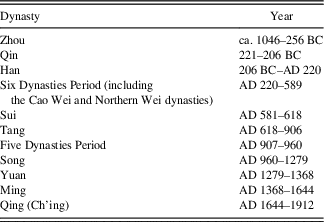
China’s rich historical and archaeological data have the potential to resolve some of the ways that human agents can shape the sedimentary record. To date, the majority of geoarchaeological studies have focused on the sedimentary dynamics of the lower Yellow River valley (Kidder et al., Reference Kidder, Liu, Xu and Li2012; Kidder and Zhuang, Reference Kidder and Zhuang2015; see Table 1 for historical timeline). In the late Holocene, the increased rate of sedimentation in the lower Yellow River valley is frequently argued to be the result of anthropogenic disturbance of the Loess Plateau (Milliman et al., Reference Milliman, Qin, Ren and Saito1987; Xu, Reference Xu2003; Shi et al., Reference Shi, Zhang, Xu and Guo2010; Kidder and Liu, Reference Kidder and Liu2014). However, sediments eroded off the hillslopes of the Loess Plateau and deposited by the Yellow River can be stored for hundreds to thousands of years in the lower Yellow River valley, making them an artifact of past climate changes, stochastic geomorphic processes, as well as anthropogenic factors such as deforestation, agriculture, and urbanism (Milliman et al., Reference Milliman, Qin, Ren and Saito1987; Ren and Zhu, Reference Ren and Zhu1994; Shi et al., Reference Shi, Zhang, Xu and Guo2010). The size of the lower Yellow River valley, as well as a diversity of climatic, fluvial, and sedimentary processes, may obscure the influence human behavior has had on the alluvial system.
Abbreviated dynastic timeline of China.

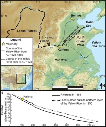
We propose that investigations of smaller tributary catchments of the Yellow River, such as the Luoyang Basin, can be used to understand some of the complexities of the interrelationship between climate, hydrology, and human activity in the lower Yellow River basin (Fig. 1; Dotterweich, Reference Dotterweich2008; Poeppl et al., Reference Poeppl, Keesstra and Maroulis2017). The Luoyang Basin is located in the dynamic middle reaches of the Yellow River and experienced a high degree of urbanism in antiquity, making the basin’s sedimentary record particularly sensitive to changes in climate, human activity, and the Yellow River. The smaller size of the Luoyang Basin (ca. 1000 km2) enables identification of basin-wide unconformities, overbank flood deposits, and soil formation, indicators of the relative role climate, hydrology, and human activity had in shaping the sedimentary history of the Luoyang Basin. We suspect that human activity has heavily modified natural sedimentary processes in the basin since at least the Han dynasty because the Luoyang Basin contained several of the world’s largest cities before the modern era. Through excavations and coring, we investigated how human-environmental interactions may have altered otherwise natural geologic processes in the Luoyang Basin and, in doing so, helped influence the history of premodern China.
(color online) (A) Geographic overview of the North China Plain and the three of the Yellow River’s courses. Locations of the ancient Yellow River’s course based on Tan (Reference Tan1986). (B) Height of the Yellow River channel in AD 1855 compared to land surface outside northern levee of the Yellow River in AD 1950. Redrawn from Ye (Reference Ye1989).

THE LUOYANG BASIN
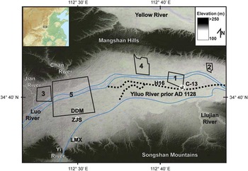
Located in western Henan Province, the Luoyang Basin is an alluvial valley circumscribed by mountains (Fig. 2). The Luoyang Basin is situated at the southern extent of the Loess Plateau. To the north, the loess-draped Mangshan Hills separate the basin from the alluvial plain of the Yellow River (Rosen, Reference Rosen2007b, Reference Rosen2008; Zhang et al., Reference Zhang, Zhang, Lee and He2007; Rosen et al., Reference Rosen, Macphail, Liu, Chen and Weisskopf2015). To the south, the Songshan Mountains, composed primarily of limestone, dolomite, and siltstone, separate the basin from the Huai River valley (Webb et al., Reference Webb, Ford and Gorton2007). Small streams, including the Chan River, Jian River, and the Gu River, erode Pleistocene- and Holocene-aged loess off the Mangshan Hills and the Songshan Mountains into the Luoyang Basin. The largest of these streams, the Yi River and the Luo River, are third-order tributaries of the Yellow River. The Yi River originates in the Xiong’er and Funiu Mountains; the Luo River originates in the Qinling Mountains. At present, the confluence of the Yi River and the Luo River is located at the eastern edge of the Luoyang Basin. In the past, the confluence of these two rivers was located farther to the west (Xia et al., Reference Xia, Zhang and Zhang2014). Hillslope erosion from the Mangshan Hills and the Songshan Mountains and flooding from the Yiluo River are two of the primary mechanisms of sedimentation in the Luoyang Basin. Backwater flooding from the Yellow River may also have occasionally deposited fine-grained sediments throughout the basin. Eolian loess deposition from the Loess Plateau and the Yellow River floodplain is another potential source of sediment (Huang et al., Reference Huang, Pang, Su, Li and Ge2009) but most likely does not account for much sedimentary deposition in the basin.
Thirty-meter Shuttle Radar Topography Mission (SRTM) image of the Luoyang Basin with urban areas (ancient capitals) outlined in black. Each city is numbered chronologically: Erlitou (1), Yanshi Shangcheng (2), Xizhou Wangcheng (3), Han-Wei Luoyang (4), and Sui-Tang Luoyang (5). Locations of cores and profiles are illustrated with open white circles overlain with their respective site codes. Map data are from the U.S. Geological Survey SRTM 1 Arc Second data set (http://www.glcf.umd.edu/data/srtm/). (For interpretation of the references to color in this figure legend, the reader is referred to the web version of this article.)

Climatic conditions of the Luoyang Basin
Climatic conditions exert a major influence over the sedimentary processes of eastern China through two primary mechanisms, the erosive power of rainfall and the protective power of plant cover (Nearing et al., Reference Nearing, Pruski and O’Neal2004). Under natural conditions, periods of high rainfall increase vegetative cover, resulting in less erosion. Periods of low rainfall diminish the amount of vegetative cover, resulting in the land surface being more susceptible to the erosive force of rainfall. In the North China Plain, the strength of the East Asian summer monsoon is one of the most important climatic factors influencing rainfall and, by association, erosion (Clift and Plumb, Reference Clift and Plumb2008, p. 159). However, as early as the Neolithic (ca. 8000–2000 BC), and certainly during historical periods, humans had either removed or altered much of the Luoyang Basin’s natural land cover, potentially amplifying the erosive power of rainfall during both wet and dry seasons (Fang and Xie, Reference Fang and Xie1994; Qiao, Reference Qiao2007).
Many paleoclimate studies have shown that past climates are not analogous to the modern climate (An et al., 2004, Reference An, Feng and Barton2006; Feng et al., Reference Feng, An, Tang and Jull2004; Cai et al., Reference Cai, Tan, Cheng, An, Edwards, Kelly, Kong and Wang2010; Dong et al., Reference Dong, Wang, Cheng, Hardt, Edwards, Kong and Wu2010; Zhang et al., Reference Zhang, Chen, Holmes, Li, Guo, Wang, Li, Lü, Zhao and Qiang2011, Liu et al., Reference Liu, Wen, Brady, Otto-Bliesner, Yu, Lu and Cheng2014). The combination of paleoclimatic proxies derived from lake sediments, peats, and speleothem archives now provides a high-resolution record of moisture and precipitation during the Holocene. Because rainfall and monsoon strength are positively correlated with one another, proxy records are often used as a means to evaluate trends in the strength of the East Asian summer monsoon (Liu et al., Reference Liu, Wen, Brady, Otto-Bliesner, Yu, Lu and Cheng2014). Researchers have suggested that the oxygen isotopes contained within speleothems can provide an index for monsoon strength (Zhang et al., Reference Zhang, Chen, Holmes, Li, Guo, Wang, Li, Lü, Zhao and Qiang2011). By combining the oxygen isotope records of speleothems, Zhang et al. (Reference Zhang, Chen, Holmes, Li, Guo, Wang, Li, Lü, Zhao and Qiang2011) suggest that rainfall and moisture peaked during the early Holocene (ca. 10.5–6.5 ka) and gradually declined ca. 6.5–4 ka (Zhang et al., Reference Zhang, Chen, Holmes, Li, Guo, Wang, Li, Lü, Zhao and Qiang2011, p. 1985). From ca. 4 to 1 ka, the moisture index is approximately similar to modern conditions (Zhang et al., Reference Zhang, Chen, Holmes, Li, Guo, Wang, Li, Lü, Zhao and Qiang2011).
However, recent research suggests that the oxygen isotope record from speleothems in China may not represent monsoon strength (Liu et al., Reference Liu, Wen, Brady, Otto-Bliesner, Yu, Lu and Cheng2014). Liu et al. (Reference Liu, Wen, Brady, Otto-Bliesner, Yu, Lu and Cheng2014) contend that the oxygen isotope record contained within speleothems located in southern China do not match with proxy data from lake sediments, peats, and paleosols in North China, an area generally considered to have reliable proxies of the East Asian monsoon. Proxy data in North China including pollen, paleosols, and eolian sand activity all suggest that the early Holocene is relatively dry. Based on these records, East Asian monsoon strength reached its peak strength from 8.6 to 3.2 ka.
From 2 ka to the present, historical records and tree ring width are increasingly used as indicators for temperature (Ge et al., Reference Ge, Hao, Zheng and Shao2013) and can corroborate speleothem records. Although speleothem records are problematic in southern China, oxygen isotope data from speleothems in Wanxiang cave, located in Gansu Province, are less significantly influenced by factors controlling the isotopic signature of speleothems in the south. Analysis of speleothems from Wanxiang cave provides a record of East Asian summer monsoon strength and precipitation from 2 ka to the present. This record suggests that around 1 ka monsoon strength decreased for about 100 yr, during a period called the Late Tang Weak Monsoon Period. Shortly afterward, the monsoon then increased intensity, during a period called the Northern Song Strong Monsoon Period. The increase in monsoon strength is concurrent with what some scholars call the Medieval Warm Period (ca. AD 950–1250; Zhang et al., Reference Zhang, Cheng, Edwards, Chen, Wang, Yang and Liu2008).
Although paleoclimatic studies in China have now achieved high temporal resolution, the relationship between climatic fluctuations and culture change remains difficult to interpret. Scientists often link cultural changes with climatic shifts (Duan et al., Reference Duan, Gan, Wang and Chien1998; Jin and Liu, Reference Jin and Liu2002; Huang et al., Reference Huang, Zhao, Pang, Zhou, Chen, Li, Mao and Ding2003; Zhang et al., Reference Zhang, Zhang, Lee and He2007; Wang et al., Reference Wang, Chen, Zhang, Yang, Li, Hasi, Zhang and Xia2010; Liu and Feng, Reference Liu and Feng2012; Li et al., Reference Li, Liu, Wu, McCloskey, Li and Gao2013; Yin et al., Reference Yin, Su and Fang2016), but no strong consensus yet exists on the effects climatic changes have had on ancient societies in China, if any. For example, some scholars argue that cold and dry climatic conditions correlate with periods of disunity and political strife in China (Zhang et al., Reference Zhang, Cheng, Edwards, Chen, Wang, Yang and Liu2008), whereas others argue that cold and dry climatic conditions created an opportunity for the emergence of more hierarchical political systems (Wu and Liu, Reference Wu and Liu2004; Liu and Feng, Reference Liu and Feng2012). Nonetheless, most scientists would agree that the cultural responses to climatic shifts are neither uniform nor self-evident (Coombes and Barber, Reference Coombes and Barber2005; Rosen, Reference Rosen2007a).
Fluvial conditions of the Luoyang Basin
The fluvial dynamics of the lower Yellow River can influence the flow of tributary streams (Shi et al., Reference Shi, Yi and Han1987; Yang et al., Reference Yang, Yu, Xie, Zhan and Li2000; Xu and Cheng, Reference Xu and Cheng2002). Tributary streams in the middle reaches of the Yellow River, such as the Yi River and the Luo River, will adjust their flow to reach equilibrium with changes in base level farther downstream (Schumm, Reference Schumm1993). This interconnectivity of the main channel of the Yellow River and its tributary streams link the sedimentary history of the Luoyang Basin to the larger paleogeographic puzzle of the Yellow River.
Historical documents indicate that the lower course of the Yellow River has breached its banks more than a thousand times and experienced major changes in its course at least 26 times in the last 3,000 yr (Tan, Reference Tan1986; Wang and Su, Reference Wang and Su2011; Chen et al., Reference Chen, Syvitski, Gao, Overeem and Kettner2012). Some geologists have argued that major floods along the Yellow River had a strong effect on ancient Chinese societies (Li et al., Reference Li, Dong, Wen and Chen2014; Wu et al., Reference Wu, Zhao, Liu, Granger, Wang, Cohen and Wu2016), making the identification of ancient episodes of overbank flooding a critical cultural question. Overbank flooding can lead to changes in the river’s course. To date, geologists have identified 10 of the Yellow River’s largest delta lobes, providing insight into the ancient Yellow River’s base level, rate of sedimentation, and influence on cultural processes (Xue, Reference Xue1993; Saito et al., Reference Saito, Wei, Zhou, Nishimura, Sato and Yokota2000, Reference Saito, Yang and Hori2001). All of the Yellow River’s deltas are located on the banks of the Bohai Sea, with the exception of one deltaic lobe that formed from AD 1128 to 1855 on the bank of the Yellow Sea. According to the sediment cores taken from each of these deltaic lobes, sedimentation rates rapidly increased during the Tang and Song dynasties, probably a result of intensive agriculture that eroded portions of the Loess Plateau (Milliman et al., Reference Milliman, Qin, Ren and Saito1987; Ren and Zhu, Reference Ren and Zhu1994; Saito et al., Reference Saito, Yang and Hori2001). Although sediment inputs into the Yellow River come from many locations, Ren and Shi (Reference Ren and Shi1986) have estimated that erosion from the Loess Plateau into the Yellow River can account for up to 90% of the river’s sediment concentration. Historically, the increased sediment load silted up the main trunk of the Yellow River, probably increasing the frequency of catastrophic overbank floods and channel migration. Overbank flooding of the Yellow River may also result in backwater flooding that could reach tributary valleys such as the Luoyang Basin.
Although the Yiluo River is susceptible to larger downstream forcing events, the flashy and uneven discharge of the Yiluo River can influence flood conditions on the Yellow River. The middle reaches of the Yellow River are particularly sensitive to monsoonal shifts and experience frequent storms (Ye et al., Reference Ye, Yang and Gao1956), making the discharge and competency of tributary streams in the middle Yellow River valley, such as the Yi River and the Luo River, extremely variable. Higher flow of the Yiluo River may increase the flood risk of the Yellow River (Ye, Reference Ye1989).
Anthropogenic influence in the Luoyang Basin
Human activity is one of the most unpredictable factors influencing sedimentation in the Luoyang Basin. Since the Neolithic, the fertile loessic soil and the defensible position of the Luoyang Basin have attracted human habitation. Neolithic occupation in the Luoyang Basin cascaded into early forms of urbanism during the Bronze Age at Erlitou, Yanshi Shangcheng, and Xizhou Wangcheng (Liu and Chen, Reference Liu and Chen2003; Liu et al., Reference Liu, Chen, Lee, Wright and Rosen2004; Shelach and Jaffe, Reference Shelach and Jaffe2014). The Luoyang Basin became a critical economic and political center during China’s imperial age. Han-Wei Luoyang and Sui-Tang Luoyang were some of the largest cities in the world at their height. Each of these cities created complex hydraulic networks that are inseparably linked to the Luoyang Basin’s sedimentary history. The large amount of archaeological work focused on the Luoyang Basin requires our discussion to be limited to discoveries particularly significant for understanding the sedimentary history of the Luoyang Basin.
Once humans reached the Luoyang Basin, they began to reorganize the sedimentary dynamics of the landscape through deforestation, agriculture, irrigation, and urban planning. On the foothills of the Songshan Mountains, sedimentary evidence from Huizui in the gully of the Liujian River suggests that people deforested the area from ca. 7000 to 5000 BC, resulting in an aggrading environment (Rosen, Reference Rosen2007b, Reference Rosen2008; Rosen et al., Reference Rosen, Macphail, Liu, Chen and Weisskopf2015). This period of aggradation stopped ca. 2000 BC as the valley began to incise. In the alluvial valley of the Luoyang Basin, archaeologists have also found evidence of canals and water storage pits at Cuoli, a late Longshan village (Wangwan III, ca. 2500 BC) located outside of the modern city of Luoyang, indicating that people manipulated the local basin hydrology of the area (Zhang, Reference Zhang2005). Archaeological evidence from Cuoli and Huizui suggests that Neolithic people were aware of their influence on the environment.
During the Bronze Age, people designed intricate systems of levees, canals, reservoirs, ditches, and city walls (Zhang, Reference Zhang2005, Reference Zhang2006; Rapp and Jing, Reference Rapp and Jing2011). The Luoyang Basin had three major urban centers in the Bronze Age, Erlitou, Yanshi Shangcheng, and Xizhou Wangcheng. These cities may have frequently faced the problems of flooding and hillslope erosion as a result of their close proximity to the Luo River and Mangshan Hills. Erlitou, one of the first urban environments in China, was located on the northern bank of the ancient Yiluo River. Many sites located next to rivers in northern China have walls as a protection against flooding (Zhang, Reference Zhang2005), but Erlitou contains no evidence of extensive hydraulic planning (Xu et al., Reference Xu, Chen and Zhao2004). After Erlitou’s decline, Yanshi Shangcheng became an important political center. Unlike Erlitou, the moat and canals of Yanshi Shangcheng join with the Yiluo River, functioning as a sewage system by directing water out of the city (Zhang, Reference Zhang2006). Although modern Luoyang city obscures much of Xizhou Wangcheng, archaeological work has also recovered evidence of hydraulic engineering at the ancient city (Zhang and Wu, Reference Zhang and Wu2006, p. 491). These emerging urban environments of the Bronze Age created artificial hydraulic networks that likely influenced natural geologic processes.
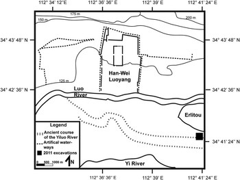
Archaeologists and historians have a clearer picture of how people altered their environment, and in particular, managed their water resources, in the Luoyang Basin during historical periods. The Luoyang Basin contained the capitals of the Han, Wei, Sui, and Tang dynasties. Much of the information about Han-Wei Luoyang comes from the Luoyang Qielanji (A Record of Buddhist Monasteries in Luoyang), one of the first historical documents to describe an ancient city in China in great detail (for translation, see Yang, 2014). Han-Wei Luoyang had a socially and economically heterogeneous population of around 400,000 persons living in a 16 km2 walled community, and the inhabitants fulfilled a variety of specialized services for the wider society (Fig. 3; Ho, Reference Ho1966; Bielenstein, Reference Bielenstein1976). These specialized services included governance and operating large grain storage facilities located in northeast of the city (Ho, Reference Ho1966, p. 87). Archaeological evidence also indicates that Han-Wei Luoyang contained sprawling suburbs, urban parks, and many artificial lakes (Duan, Reference Duan2009; Chen et al., Reference Chen, Zhou and Guo2011). A complex system of canals facilitating trade and sanitation supported the large population at Han-Wei Luoyang (Ho, Reference Ho1966, p. 69; Du and Koenig, Reference Du and Koenig2012). A central feature of this canal system was the partially channelized Luo River, located at the far southern portion of the city. Sometime after the Northern Wei dynasty, the Luo River eroded away the southern portion of Han-Wei Luoyang’s inner city walls.
Simplified drawing of an archaeological plan view of Han-Wei Luoyang (redrawn from Liu et al., Reference Liu, Lu and Lai1995). Note the ancient course of the Yiluo River. The modern Luo River has eroded away the wall of the inner city. The location of Han-Wei Luoyang is shown in Figure 2.

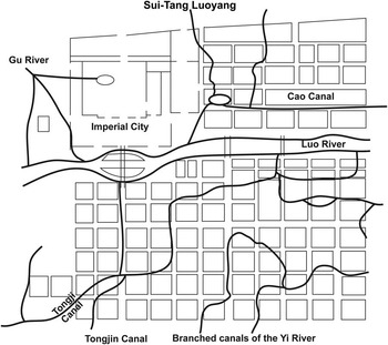
In AD 605, the Sui dynasty emperor moved the dynastic capital back to the Luoyang Basin to better take advantage of commerce on the North China Plain, as well as in the lower Yangtze River valley and Huai River valley. Known through the Sui Shu (The Book of Sui) and archaeological work at Sui-Tang Luoyang (Zhongguo Shehui Kexueyuan Kaogu Yanjiusuo, 2014), Sui-Tang Luoyang reached an estimated population of more than a million people (Liu et al., Reference Liu, Lu and Lai1995). Sui-Tang Luoyang, much like Han-Wei Luoyang, was a vibrant and prosperous seat of governance (Steinhardt, Reference Steinhardt1999). Hydraulic engineering projects at Sui-Tang Luoyang were essential to the Sui dynasty’s, and later the Tang dynasty’s, economic ambitions. Sui-Tang Luoyang was connected to southern and northern China through a series of artificial waterways called the Grand Canal. The Tongji Canal, a part of the Grand Canal that leads from the Luoyang Basin to the Haui River valley, was created by rerouting the Yi River, in the south, and the Chan, Jian, and Luo Rivers, in the north, through Sui-Tang Luoyang (Fig. 4; Du and Koenig, Reference Du and Koenig2012, pp. 175–176). The northern half of the city has a lower elevation than the southern half of the city, making the rivers prefer a more northern course (Zhang and Wu, Reference Zhang and Wu2006; Du and Koening, Reference Du and Koenig2012, p. 176). Although there were many canals and water courses in Sui-Tang Luoyang, only the Luo River and the Cao Canal (a part of the Tongji Canal that headed east to connect with the Grand Canal) removed water from the city. The limited outlet for water often resulted in floods in the city. Historians have used both official histories and local gazetteers to demonstrate that floods frequently damaged portions of Sui-Tang Luoyang (Wang, Reference Wang2003; Zhu, Reference Zhu2006; Li, Reference Li2007), some of which have been correlated with sedimentary evidence (Xu et al., Reference Xu, Mo, Zhou and Wang2013). Despite the occasional floods, Sui-Tang Luoyang was a powerful economic and political hub until the An Lushan rebellion (AD 755–763). Even though the Tang dynasty quelled the rebellion, An Lushan’s army burned down most of Luoyang, and the city never fully recovered. The emperor moved the capital back to Chang’an. By AD 1127, Sui-Tang Luoyang was more or less abandoned (Xu et al., Reference Xu, Mo, Zhou and Wang2013). Although the Luoyang Basin was still populated after Sui-Tang Luoyang’s abandonment, the area never regained the political and economic importance it once had during the Han, Wei, Sui, or Tang dynasty.
Schematic drawing of Sui-Tang Luoyang (redrawn from Chen, Reference Chen1983). The Luo River is constrained and channelized within the confines of the city. The Luo River naturally moves north, potentially enabling the Luo River to capture the Cao Canal. The location of Sui-Tang Luoyang is shown in Figure 2.

In aggregate, the sedimentary and archaeological remains left behind by Neolithic to late Imperial populations in the Luoyang Basin may have rendered the alluvial basin a mixture of urban debris, relict artificial ponds and streams, and modified ancient river courses. The deep human imprint on the Luoyang Basin complicates predicting the effects that climatic change and the Yellow River’s fluvial dynamics may have had on the sedimentary history of the basin.
METHODS
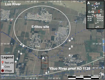
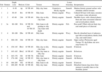
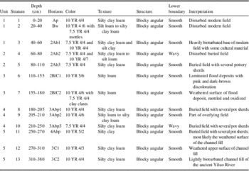
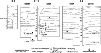
The influence that climatic, fluvial, and anthropogenic factors have had on the sedimentary history of Luoyang Basin has varied throughout time. To start evaluating the strength of these three factors relative to time, we conducted geoarchaeological fieldwork in the Luoyang Basin in 2011. With assistance from the Erlitou Archaeological Workstation of the Chinese Academy of Social Sciences, we conducted a two-stage research project immediately south of the Erlitou site to examine the sedimentary history of the Luoyang Basin. In the first phase, we conducted a subsurface coring survey to determine the spatial extent of the paleochannel south of Erlitou. Using a Luoyang spade (an expedient hand-powered, split-spoon auger), we augered boreholes approximately every 20 m on south–north and east–west transects to the immediate south of Erlitou. On the western and eastern edge of Erlitou, we placed three boreholes on a south–north transect approximately every 200 m. In total, we augered 28 boreholes and confirmed the location of a paleochannel south of Erlitou, corroborating the findings of previously published reports (Xu et al., Reference Xu, Chen and Zhao2004; Xia et al., Reference Xia, Zhang and Zhang2014; see Supplementary Table 1 for auger data). In the second phase, we excavated three locations: C-1 (112°41′27.20″E, 34°41′10.10″N), C-2 (112°41′27.40″E, 34°41′3.70″N), and C-13 (112°41′27.20″E, 34°41′5.50″N; see Fig. 5). We excavated C-1 into Terrace T2 of the ancient Yiluo River, and we excavated C-13 and C-2 into Terrace T1, the channel fill deposits of the ancient Yiluo River. We described each test trench using standardized notation, including Munsell color, structure, texture, and inclusions (Birkeland, Reference Birkeland1999; Staff, Reference Staff1999; Vogel, Reference Vogel2002; Holliday, Reference Holliday2004; Tables 2 and 3). We collected both bulk sediment and micromorphology samples to verify our field observations, as well as samples for radiocarbon and optically stimulated luminesce (OSL) dating from each of these excavations.
Location of C-1, C-2, C-13, and cores described in summer 2011 directly south of the Erlitou site (see Supplementary Table 1 for core descriptions). The sediments we interpret as following the ancient course of the Yiluo River are outlined in blue. The location of Erlitou is shown in Figure 2. (For interpretation of the references to color in this figure legend, the reader is referred to the web version of this article.)

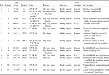
C-1 stratigraphic description.
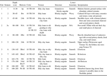
Combined stratigraphic description of C-2 and C-13.
Laboratory methods
We combined quantitative analyses such as loss on ignition, particle size, and magnetic susceptibility, with qualitative micromorphological analysis to test our field observations. We conducted all quantitative analyses, including particle size, loss on ignition, and magnetic susceptibility, at the College of Urban and Environmental Studies at Peking University. Prior to analysis, all samples were air-dried and weighed. Particle size was measured using a Malvern Mastersizer 2000 laser diffraction particle size analyzer. Prior to analysis, samples were pretreated for organic and carbonate removal in a 10% HCl and 30% H2O2 solution, respectively. Loss on ignition was conducted following standard procedures to determine the amount of organic and inorganic carbon lost during ignition at 550°C and 950°C (Nelson and Sommers, Reference Nelson and Sommers1996; Heiri et al., Reference Heiri, Lotter and Lemcke2001). Magnetic susceptibility, a measure of a soil’s ability to be magnetized (Dalan and Banerjee, Reference Dalan and Banerjee1996), was taken with a Bartington MS2 Magnetic Susceptibility Meter for both high (4.7 kHz) and low (0.47 kHz) field magnetism.
Micromorphological analysis was done at the Geoarchaeology Laboratory at Washington University in St. Louis. Goldberg and Aldeias (Reference Goldberg and Aldeias2016) advocate for the more common usage of micromorphology in geoarchaeological work to link data derived from quantitative bulk analyses to their microstratigraphic contexts by providing a visual reference for stratigraphic features (e.g., Zhuang et al., Reference Zhuang, Bao and French2016). We provide scans of thin sections from each of the contexts discussed in the results to visually match sedimentary features with bulk analyses and chronometric data. All micromorphology samples were sent to Spectrum Petrographics Inc. for processing into thin sections. After the samples were prepared into thin sections, we used an Axio Lab A1 cross-polarizing microscope to describe microscopic features according to international standards (Courty et al., Reference Courty, Goldberg and Macphail1989; Stoops, Reference Stoops2003).
We also dated two radiocarbon samples and five OSL samples. Beta Analytic completed the radiocarbon dating of two samples retrieved from C-13 (Table 4). Five OSL dates were processed at the Archaeometery Laboratory of Peking University’s School of Archaeology and Museology using the SAR (single aliquot regenerative-dose) method on quartz grains sized from 4 to 11 μm (Murray and Wintle, Reference Murray and Wintle2000; Table 5). All OSL samples were prepared under subdued red light. Sediment at the end of the sampling tubes was removed to reduce the chance of measuring contaminated quartz. The sample was then pretreated with HCl, sodium oxalate (Na2C2O4), and H2O2, to dissolve carbonate, aggregated clumps, and organic matter, respectively. The fine-grained fraction (4–11 μm) was then extracted following protocols outlined by Frechen et al. (Reference Frechen, Schweitzer and Zander1996). The separated 4–11 μm fraction was then etched using hydrofluorosilicic acid (H2SiF6) for 6 days to extract quartz fractions. The purity of quartz for each aliquot was checked using the infrared depletion ratio (Duller, Reference Duller2003). No significant infrared signal was observed, indicating that the isolation of quartz was successful. The quartz extracts were mounted on aluminum discs (diameter 9.7 mm) from a suspension in distilled water (2 mg quartz fine grain per disc) for luminescence measurement. An alpha efficiency factor (a-value) of 0.04 for quartz was used to calculate the alpha dose rate (Rees-Jones, Reference Rees-Jones1995). Using Adamiec and Aitken’s (Reference Adamiec and Aitken1998) revised dose-rate conversion factors, the elemental concentrations were converted into an equivalent dose rate (D e ) with the “AGE” program of Grun (Reference Grun2009). The cosmic dose rate (Gy) was calculated using the AGE program from the latitude and depth of the samples.
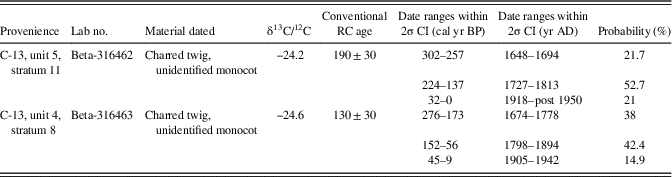
Radiocarbon dates from C-13. All dates are calibrated with the program OxCal 4.2 (Bronk Ramsey, Reference Bronk Ramsey2009) using the IntCal13 14C data set (Reimer et al., Reference Reimer, Bard, Bayliss, Beck, Blackwell, Ramsey and Buck2013).

Note: RC, radiocarbon; CI, Confidence intervals.
Optically stimulated luminescence (OSL) dates.

RESULTS
The results of the core survey are presented in Supplementary Table 1 but are generally represented by our excavations at C-1, C-13, and C-2.
Terrace T2: C-1
The site of Erlitou sits on a Pleistocene-aged fluvial terrace of the ancient course of the Yiluo River. C-1 is located at the southern edge of Terrace T2 (Fig. 6 and Supplementary Fig. 1, Table 2). We divide the stratigraphy found at C-1 into three separate lithostratigraphic units.

Unit 3 (100–200 cm): Down cutting of the Yiluo River at end of the Pleistocene created unit 3. The soil is heavily weathered and blocky. There appear to be multiple surfaces in the unit, suggesting periods of differential weathering. An OSL sample from the upper portion of the unit returned a date of 12±0.98 ka.
Unit 2 (50–100 cm): Unit 2 is a thick cultural horizon. We found Longshan (ca. 3000–2000 BC) and Erligang (ca. 1500–1400 BC) pottery sherds within unit 2. We also identified a pit that contained a post mold and a thick layer of plaster that may be refuse from a nearby Neolithic or Bronze Age house. Stratum 11 downcuts the Pleistocene terrace with near-perfect verticality.
Unit 1 (0–50 cm): Unit 1 is the modern land surface. There is a great deal of cultural material on the surface because modern agricultural activity has disturbed the archaeological site of Erlitou.
Terrace T1: C-13 and C-2
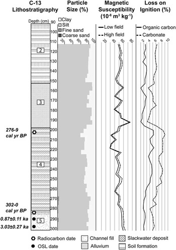
The ancient channel of the Yiluo River is located to the immediate south of Erlitou. C-2 (Fig. 6, Table 3) and C-13 (Figs. 6 and 7, Table 3) are located on the northern edge of this paleochannel. We divide the stratigraphy into five separate lithostratigraphic units. Particle size, magnetic susceptibility, and loss-on-ignition data from C-13 are presented in Figure 8.
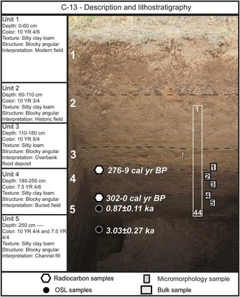
(color online) Photograph of C-13 with lithostratigraphic divisions. Sample locations are not exact; see profile drawings for exact location. Scale bar is 20 cm.

Lithostratigraphy, particle size, magnetic susceptibility, and loss on ignition of 44 bulk samples from C-13.

Unit 5 (250 cm–unexcavated): Unit 5 starts approximately 2.5 m below the ground surface and continues for at least another meter. The texture of this deposit is a silty loam. We observed that the soil was heavily reduced, indicating the sediment was submerged more or less continuously as the deposit formed. These deposits are most likely the channel fill of the ancient Yiluo River. We also identified several small, weathered fragments of pottery. C-13-5MM is poorly sorted and contains large pieces of tufa and charcoal. Our OSL dates indicate that the last sediments of the paleochannel were deposited around 0.87±0.11 ka. A dark incipient soil that formed within the material of the paleochannel (stratum 11) overlies the paleochannel deposit. Both C-13-4MM and C-13-5MM share a similar groundmass, suggesting that the paleosol formed within the paleochannel’s lag deposits. A radiocarbon date from this layer returned a calibrated date (2σ) of 302–0 cal yr BP, with a probability distribution of 302–257 cal yr BP (21.7%), 224–137 cal yr BP (52.7%), and 32–0 cal yr BP (21%), providing a terminus post quem for the overlying stratigraphic sequence.
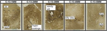
Unit 4 (200–250 cm): Unit 4 is a series of cumulic paleosols that are heavily oxidized and turbated. These paleosols contain many angular, 7.5 YR 4/4 rotated silty clay clasts. Because of the clay-rich nature and the reddish soil color of most of this deposit, the parent material of the paleosol may originate from slack-water flooding. The bottom portion of this unit is weakly gleyed. The micromorphology sample, C-13-4MM, corroborates our field distinction between stratigraphic units. The contact between unit 5 and unit 4 is abrupt (<2 mm) and suggests an abrupt change in sedimentary processes. The interface between unit 5 and unit 4 is clearly seen in the middle of C-13-4MM—dusty clay coatings form the boundary between the two units (Fig. 9). Excavation and micromorphological analysis of C-13-3MM, C-13-2MM, and C-13-1MM suggest that anthropogenic disturbance is prevalent in unit 4. The rotated sandy silt overbank flood deposit seen in C-13-3MM, C-13-2MM’s channel microstructure, silty clay concentration features seen in C-13-1MM, and carbonized husk of an unidentified grain found in excavation with pottery sherds all suggest that unit 4 may be a buried rice-paddy agricultural context (Lee et al., Reference Lee, French and Macphail2014). A radiocarbon date from the top of this deposit returned a calibrated date (2σ) of 276–9 cal yr BP, with a probability distribution of 276–173 cal yr BP (38%), 152–56 cal yr BP (42.4%), and 45–9calyrBP (14.9%).
(color online) Micromorphology of C-13. Each slide is 5×7 cm large. (1) C-13-1MM: note the boundary between the silty sand (quartz, qz) and silty clay groundmass. Also note the silty clay concentration features (sccf). (2) C-13-2MM: channel microstructure with iron oxide hypocoatings. (3) C-13-3MM: note the large rotated sandy silt clast in the center of the slide; we interpret this as anthropogenic activity. (4) C-13-4MM: note the abrupt boundary between unit 4 and unit 5 at the middle of the slide; this is what we interpret as the unconformity. (5) C-13-5MM: channel fill from the ancient Yiluo River channel; note the large inclusion of charcoal (char) and tufa.

Unit 3 (150–200 cm): Unit 3 is a series of overbank flood sediments with laminated deposits, ranging in size from silt to fine clay. This unit contains strongly oxidized clay lenses interbedded with silty sediment. Micromorphological analysis of C-13-1MM shows the quartz-rich sandy silt overbank flood deposit overlying, and potentially eroding, portions of unit 4. We observed several laminated bands of microcharcoal within the sample, revealing that pulses of alluvium contained charcoal flecks from upstream.
Unit 2 (60–150 cm): We observed large, angular, silty clay clasts throughout unit 2, along with small pottery fragments. This layer is heavily reoxidized, indicating yearly inundation and a receding water table.
Unit 1 (0–60 cm): Unit 1 is the modern land surface and underlying weathered B horizon. Small amounts of cultural material are located throughout this level.
DISCUSSION
Interpretation of C-1, C-13, and C-2
Our excavations at C-1, C-13, and C-2 corroborate the findings of other stratigraphic work done around Erlitou (Zhang and Xia, Reference Zhang and Xia2011, Reference Zhang and Xia2012; Xia et al., Reference Xia, Zhang and Zhang2014). The OSL date from C-1 verifies previous reports that Erlitou is located on a Pleistocene-aged T2 terrace immediately adjacent to the ancient course of the Yiluo River. However, the proximity of the 12±0.98 ka OSL-dated Pleistocene-aged T2 terrace and the cultural material dating to the Longshan period requires explanation. Several scenarios are possible. Slow soil formation and minimal inputs from overbank flooding during the early and middle Holocene or the incision of the Yi and Luo Rivers for the majority of the early and middle Holocene could explain the chronology of our excavation at C-1. However, given the intensity of occupation at Erlitou, we are inclined to believe that Bronze Age people disturbed large portions of the Pleistocene terrace underlying the settlement of Erlitou, potentially removing several millennia of soil accumulation.
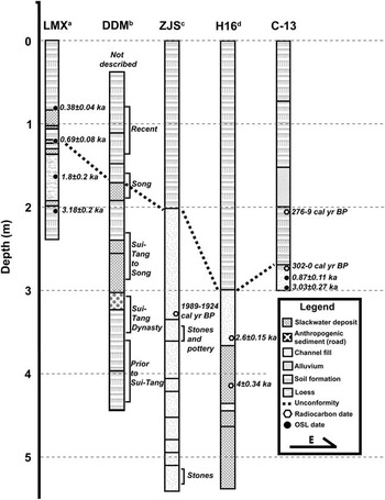
At C-13 and C-2, our excavations revealed two phases of deposition. The first phase is sediments left behind from the ancient channel of the Yiluo River, with a period of incipient soil formation at the top (unit 5). The second phase is a period of rapid sediment accumulation above the paleochannel (units 4 through 1). We interpret unit 5 in C-13 and C-2 as the relict channel of the Yiluo River based on the depth, sorting, weakly gleyed sediment, and massive nature of the deposit. Although we did not reach the bottom of this deposit, other workers have excavated and dated several additional locations of the Yiluo River paleochannel with depths and dates similar to our results (Fig. 10). Our OSL dates suggest that the ancient channel of the Yiluo River flowed through this location up to at least the middle of the twelfth century AD. Around this time, the channel fill terminates, indicating that the ancient course of the Yiluo River migrated. The chronological difference and the close stratigraphic position between the OSL date of 0.87±0.11 ka and the deepest radiocarbon sample, which returned a calibrated date (2σ) of 302–0 cal yr BP, with 224–137 cal yr BP comprising more than half of the probability distribution, suggests deposition likely stopped for around 600 yr after the ancient course of the Yiluo River migrated, allowing a soil to form on top of the channel’s lag deposit. After this period of soil formation, more than 2 m of sediment accumulated in approximately 150 to 300 yr.
Lithostratigraphic diagram using data from Longmenxia (LMX; Zhao et al., Reference Zhao, Huang, Pang, Zha, Guo and Hu2016) (a), Dingdingmen (DDM; Xu et al., Reference Xu, Mo, Zhou and Wang2013) (b), Zaojiaoshu (ZJS; Zhang and Wu, Reference Zhang and Wu2006) (c), H16 (dates presented in Xia et al. [Reference Xia, Zhang and Zhang2014] are derived from Zhang and Xia [Reference Zhang and Xia2011]) (d), and C-13. The locations of each of these lithostratigraphic sections are shown in Figure 2. The black line demarcates the Song dynasty unconformity between columns. Raw radiocarbon dates found within these publications have been calibrated with OxCal 4.2 (Bronk Ramsey, Reference Bronk Ramsey2009) using the IntCal13 14C data set (Reimer et al., Reference Reimer, Bard, Bayliss, Beck, Blackwell, Ramsey and Buck2013). All dates reported are as found in the original publications. The data presented in these articles have been translated by the authors.

The relatively close stratigraphic position of the radiocarbon dates permits averaging their age. Using OxCal’s age combination algorithm, the combined radiocarbon dates range from 285–0 cal yr BP, with a probability distributions of 285–254 cal yr BP (16.3%), 222–166 cal yr BP (43.3%), 155–136 cal yr BP (10.6%), 115–73 cal yr BP (5.8%), and 34–0 cal yr BP (19.4%). According to this combination, there is a 19.4% chance that these radiocarbon dates are derived from a modern context, but the profile showed no signs of modern disturbance. The deposits in both C-13 and C-2 were both stratified and intact. Moreover, the raw radiocarbon dates are not inverted, supporting the integrity of these dates. Based on the stratigraphic and chronological evidence, we argue that the ~600 yr unconformity found in C-13 is real.
Comparing other sedimentary records in the Luoyang Basin
After comparing our field and laboratory work with existing sedimentary data, we believe that the unconformity observed in C-13 and C-2 from the twelfth to the nineteenth centuries AD might be widespread throughout the Luoyang Basin. Sedimentary data from Longmenxia (Zhao et al., Reference Zhao, Huang, Pang, Zha, Guo and Hu2016), Zaojiaoshu (Zhang and Wu, Reference Zhang and Wu2006), Dingdingmen (Xu et al., Reference Xu, Mo, Zhou and Wang2013), and borehole data collected around the Erlitou site (H16; Xia et al., Reference Xia, Zhang and Zhang2014) may also contain evidence for this unconformity (Fig. 2). An OSL date of a slack-water deposit from Longmenxia, a profile along the Yi River, indicates that at 0.68±0.40 ka, approximately the same time frame as the terminal date of the channel fill found in C-13, the Yi River had an overbank flood. The next slack-water flood at Longmenxia dates to 0.38±0.04 ka, approximately the same time frame within which deposition resumes at C-13 and C-2. A radiocarbon date from a stratigraphic profile nearby Zaojiaoshu, an archaeological site located south of modern-day Luoyang, suggests that the Yi River flowed to the south of Luoyang 1989–1924 cal yr BP (Zhang and Wu, Reference Zhang and Wu2006). Although there are no dates on the top layer of the ancient Yi River’s channel fill or the bottom of the overlying strata from the Zaojiaoshu profile, the channel fill deposit ends at 2 m below ground surface, approximately the same depth of the unconformity found at both C-2 and C-13. This suggests that the Yi River’s course may have changed at a time roughly contemporaneous with the unconformity. At another stratigraphic profile, Dingdingmen, also located south of modern Luoyang, Xu et al. (Reference Xu, Mo, Zhou and Wang2013) dated the last flood deposit in the stratigraphic sequence to AD 1078—all the deposits above this flood sediment are classified as recent (after AD 1800). In 2007, geologists conducted an extensive coring program around Erlitou describing 46 cores. Some of these cores contained Han and Wei dynasty ceramics, but none contained ceramics postdating the Song dynasty (Xia et al., Reference Xia, Zhang and Zhang2014). The lack of archaeological evidence for post–Song dynasty cultural material and the relatively similar depth and chronology of different lithostratigraphic units throughout the basin suggest that the unconformity found south of Erlitou might be widespread throughout the Luoyang Basin, but more evidence will be needed to support this claim (Fig. 10).
Climatic, fluvial, and anthropogenic origins of the unconformity spanning the twelfth to nineteenth centuries AD
Assuming the unconformity is widespread and real, the origins of this ~600 yr unconformity may lie in changes in climate, fluvial regime, or anthropogenic disturbance. A possible explanation for the unconformity is the climate at the end of the Tang dynasty and the beginning of the Song dynasty (Zhao et al., Reference Zhao, Huang, Pang, Zha, Guo and Hu2016). Climate records indicate that the East Asian summer monsoon became weaker at the end of the Tang dynasty during the Late Tang Weak Monsoon Period (Zhang et al., Reference Zhang, Cheng, Edwards, Chen, Wang, Yang and Liu2008). Diminished amounts of rainfall, combined with more intensive agricultural production on the slopes of the Mangshan Hills and the Songshan Mountains, may have temporarily increased hillslope erosion into the Luoyang Basin, which may have primed the Yiluo River to reach a geomorphic threshold. When the East Asian summer monsoon strengthened during the Northern Song Strong Monsoon Period, the increased amount of rainfall may have triggered geomorphic responses, allowing the Luo River to move to the north and push the confluence of the Yi and the Luo Rivers farther east. Although this hypothetical situation does explain the current location of the Luo River and the origin of the unconformity, it does not explain why sedimentation did not resume for more than 600 yr.
Anthropogenic disturbance and changes in the Yellow River’s course may better account for the unconformity observed in the Luoyang Basin. Although we cannot rule out climate as a factor in creating this unconformity, the starting and ending dates of the unconformity observed in C-13 and C-2 are roughly coincident with two major, human-influenced switches in the main course of the Yellow River in AD 1128 and AD 1855.
In AD 1128, the Jurchen army invaded the Song empire from the north. Du Chong (?–AD 1141), the governor of Kaifeng, ordered his army to breach the bank of the Yellow River near Kaifeng in the hope that the resultant flood would hinder the advance of the Jurchen army. Du Chong’s plan failed miserably; the flood did not stop the Jurchen army’s advance, rather the catastrophic flood dramatically shifted the Yellow River’s course to the south, destabilizing the region for hundreds of years (Lamouroux, Reference Lamouroux1998; Zhang, Reference Zhang2016). For the first time during the late Holocene, the Yellow River captured the Huai River and flowed out to the Yellow Sea (Zhang, Reference Zhang2009).
The sudden drop in the Yellow River’s base level may have changed the channel dynamics of the Yiluo River from aggradation to incision. The newly steepened gradient of the Yi River and the Luo River would have resulted in a relatively rapid increase in the rivers’ potential energy. The increase in potential energy possibly enabled the Luo River to incise through attempts to artificially constrict its course. Many of the canals leading out of Sui-Tang Luoyang were poorly maintained after the An Lushan rebellion (AD 755–763), potentially triggering the Luo River to capture the Cao Canal (the upper course of the Tongji Canal) leading out to the north of Sui-Tang Luoyang. The unnaturally straight course of the Luo River has led Fang (Reference Fang1999) and Duan (Reference Duan2009) to propose that the Tongji Canal became the course of modern Luo River. After capturing the Tongji Canal, the Luo River probably cut a course to the east through the easily eroded sediment of an abandoned moat or canal of Han-Wei Luoyang. The new course of the Luo River would have followed the ancient hydraulic features of Han-Wei Luoyang through the abandoned city, eroding away the southern portion of Han-Wei Luoyang’s inner city wall. For the next 600 yr, as the rivers of the Luoyang Basin equilibrated with the new gradient of the Yellow River, deposition halted.
In AD 1855, heavy summer rainfall magnified the flood stage of the lower reaches of the Yellow River, straining the Qing dynasty’s poorly maintained levees that surrounded the Yellow River. Eventually, the levees could no longer hold back the massive amount of water. At Tongwaxiang, Henan Province, the Yellow River broke free of the artificial levees, inundating the surrounding countryside. The accumulated sediments from upstream erosion of the Loess Plateau raised the topography south of the Shandong peninsula, forcing the river to the north (Qian, Reference Qian1990; Marks, Reference Marks2012; Wang et al., Reference Wang, Lee and Melching2014, p. 350). The river quickly captured the Daqing River, heading toward the Bohai Sea. Although the flood did not originate from an individual’s decision to breach levees, the Qing dynasty’s mismanagement of the Yellow River played a large role in creating the conditions for this major channel switch (Dodgen, Reference Dodgen1991, Reference Dodgen2001).
It is highly likely that widespread environmental problems during the Qing dynasty resulted in the rapid sedimentation of the Luoyang Basin (He et al., Reference He, Tang and Zhang2004). Wang et al. (Reference Wang, Shao, Wang and Gale2006) argue that advantageous tax policies led to large numbers of people moving to the Loess Plateau during the Qing dynasty. From 1750 to 1860, the registered population on the Loess Plateau population increased from around 23 million to more than 40 million people (Zhao et al., Reference Zhao, Mu, Wen, Wang and Gao2013, p. 502). The increase in population strained existing water and land resources, resulting in the environmental degradation of the Loess Plateau. The northward shift of Yellow River’s course in AD 1855 and the deforestation of the Loess Plateau most likely resulted in the Yi River and the Luo River changing from nondeposition to aggradation and can account for the rapid sedimentation rates found in the Luoyang Basin.
Historical, sedimentary, and archaeological evidence point to an anthropogenic origin of the Yellow River’s channel avulsions in AD 1128 and AD 1855, but gravity dictated the fluvial system’s response to anthropogenic interference. Why the AD 1128 Yellow River channel switch to the south forced the Yiluo River to become incisional, whereas the AD 1855 Yellow River channel switch to the north had the opposite effect, remains unclear, but two hypotheses could possibly explain the different fluvial responses. First, the difference between the relative sea level of the Bohai Sea and the Yellow Sea may have caused the Yiluo River to switch to incision (Zaitlin et al., Reference Zaitlin, Dalrymple and Boyd1994). Although sea level is often thought of as a fixed height, the height of the sea relative to a fixed point on a landmass varies seasonally. Both the relative height of the Yellow Sea and the Bohai Sea are affected by monsoon strength and other factors, which can increase the difference between these two relative sea levels (Han and Huang, Reference Han and Huang2008). In AD 1128, the sea level of the Yellow Sea may have been lower than the Bohai Sea, whereas in AD 1855, the sea level of the Bohai Sea may have been higher relative to the Yellow Sea. Second, the absence of a highly developed deltaic system in the Yellow Sea region may have meant that the Yellow River did not deposit sediment on a prograded delta, potentially shortening the Yellow River’s path to the sea (Ren and Shi, Reference Ren and Shi1986). Both hypotheses require further testing.
Zhao et al. (Reference Zhao, Huang, Pang, Zha, Guo and Hu2016) link changes in sedimentation in the Luoyang Basin to climatic shifts, but we contend that neither shifts in climate nor gradual environmental degradation can account for the sudden appearance of the stratigraphic unconformity in the Luoyang Basin. By combining the detail of the historical record with sedimentary and archaeological evidence, we can attribute the unconformity observed in the Luoyang Basin to human actions in Luoyang Basin and downstream in the Yellow River floodplain. The sedimentary history of the Luoyang Basin is a complex combination of climate, fluvial dynamics, and anthropogenic activity, but the archaeological deposits left behind from the urban environments of Han-Wei Luoyang and Sui-Tang Luoyang may have structured the Yi and the Luo Rivers’ response to changes in the Yellow River’s course. Likewise, Du Chong’s decision to breach the banks of the Yellow River in AD 1128 and, later, the Qing dynasty’s mismanagement of the Yellow River and the Loess Plateau provide an explanatory framework for both the origin and termination of the unconformity, as well as the rapid rate of post–AD 1800 sedimentation found in the Luoyang Basin.
Decision makers in the late Holocene, either at an individual level, such as Du Chong, or in aggregate, such as the hydraulic bureaucracy of the Qing dynasty government, wielded great power over the environment. However, neither Du Chong’s decision to breach the banks of the Yellow River in AD 1128 nor the Qing dynasty government’s mismanagement of the Yellow River can be removed from the socionatural context of their time. On one hand, individuals make historically contingent, but not random, decisions that influence the course of history. Once Du Chong breached the bank of the Yellow River, natural systems, as well as sociopolitical systems, had to adjust to the new course of the Yellow River. On the other hand, the decisions made by large institutions are burdened by their history. The Qing dynasty government’s failure to manage both the Loess Plateau and the Yellow River was a result of inherited environmental problems and ineffectual policies, complemented by rapid population growth and unsustainable resource use (Pomeranz, Reference Pomeranz2010). As a result, in AD 1855, extreme weather pushed an already primed Yellow River over a geomorphic threshold, causing the Yellow River to channelize to the north. Although the lower course of the Yellow River seems far removed from the Luoyang Basin, downstream events can have wide-ranging ramifications for upstream basin dynamics.
The sedimentary history of the Luoyang Basin is a reminder that environmental impacts are partly agentive processes. Human impacts on the earth system are often described as the inevitable result of more people increasingly exploiting the environment (Ellis et al., Reference Ellis, Kaplan, Fuller, Vavrus, Goldewijk and Verburg2013), but rarely are decision makers implicated in shaping anthropogeomorphic processes in antiquity. Geoarchaeological work conducted in small river basins, such as the Ying River valley (Wang et al., Reference Wang, Zhang, Zhang and Fang2015) and the Huan River valley (Rapp and Jing, Reference Rapp and Jing2011), will continue to be ideal places to explore the interconnections between human agency, climatic conditions, and geomorphic change (Dotterweich Reference Dotterweich2008, Reference Dotterweich2013).
CONCLUSION
After weighing the relative importance of climate, fluvial dynamics, and anthropogenic disturbance, we argue that anthropogenic disturbance in the lower reaches of the Yellow River resulted in major changes within the Luoyang Basin’s sedimentary record during the late Holocene. An abrupt stratigraphic and chronological unconformity found in our 2011 excavation units C-2 and C-13 indicate that an abrupt change in geologic processes occurred ca. AD 1100. Our stratigraphic data suggest that the ancient Yiluo River was located directly south of Erlitou until ca. AD 1100. Given the uncertainties of numerical dating methods, these dates are roughly contemporaneous with the governor of Kaifeng’s decision to breach the levees on the Yellow River in AD 1128, causing the Yellow River to flow south to the Yellow Sea for the first time in the late Holocene. We argue that this historic event is a potential cause for the unconformity seen in our excavations. The rapid drop in the Yellow River’s base level would have changed the Yi River and the Luo River from an aggrading to incising system. After synthesizing the available historical and sedimentary data, we propose that, as a result of the Yellow River’s new base level, the Luo River captured several poorly maintained canals around Sui-Tang Luoyang and eroded away the southern portion of Han-Wei Luoyang’s city wall, forming the modern channel of the Luo River. Based on our data, deposition in the Luoyang Basin more or less halted as the basin’s rivers equilibrated to the new gradient of the Yellow River. Deposition did not resume in the basin until ca. AD 1800. The Luoyang Basin’s sudden switch from nondeposition to deposition is linked to widespread environmental degradation in the Qing dynasty and the AD 1855 avulsion at Tongwaxiang, which rerouted the course of the Yellow River from the Yellow Sea back north to the Bohai Sea.
Although many paleoenvironmental studies imply that anthropogenic environmental change is a gradual process, this study suggests that, in conjunction with the gradual accumulation of environmental modifications and climatic changes, the decisions of human agents can have long-lasting environmental ramifications in antiquity. Agriculture, urbanism, and deforestation all have sedimentary consequences, but the decision to breach the banks of the Yellow River in AD 1128 may have changed the fluvial dynamics of the Yiluo River in unanticipated ways for hundreds of years, overwhelming climatic or fluvial signatures. By combining China’s rich historical and archaeological record with sedimentary data from the Luoyang Basin, it may be possible to resolve how an agentive decision can cascade through a fluvial system.
Acknowledgments
We gratefully acknowledge the assistance of the Erlitou Archaeological Workstation at the Chinese Academy of Social Sciences. This fieldwork was supported by the International Center for Advanced Renewable Energy and Sustainability (grant #2012-03) at Washington University in St. Louis and the Henan Distinguished Research Fellow Fund and Key Issue of Origin of Chinese Civilization and Mount Songshan Civilization Zhengzhou Research Association. We also thank three anonymous reviewers, Derek Booth (senior editor), David J. Meltzer, and John Dodson (associate editor) for their helpful comments and suggestions.
SUPPLEMENTARY MATERIAL
To view supplementary material for this article, please visit https://doi.org/10.1017/qua.2017.10