Maya archaeology has long contemplated the political organization of Classic Maya society (de Montmollin Reference de Montmollin1989; Fash Reference Fash1994; Lucero Reference Lucero1999; Marcus Reference Marcus, Sabloff and Henderson1993; Sharer and Golden Reference Sharer, Golden, Golden and Borgstede2004). In fact, great strides have already been made in our understanding of both the large centers that dominated the Maya area in the Classic period (a.d. 200–900) and the smaller settlements Maya rulers claimed to have controlled (Ashmore Reference Ashmore1981; Ashmore and Wilk Reference Ashmore, Wilk, Wilk and Ashmore1988; Iannone and Connell Reference Iannone and Connell2002; Marcus Reference Marcus2003). But the internal workings of Classic Maya polities—and the extent to which they were integrated at all—remains the subject of intense debate.
While a thorough review of Maya political organization is beyond the scope of this article, it may be argued that models of political integration within the Maya area tend to conceptualize Maya polities as either weakly organized entities focused on the control of people and networks (de Montmollin Reference de Montmollin1995; Demarest Reference Demarest, Demarest and Conrad1992; Fox and Cook Reference Fox and Cook1996; Sanders Reference Sanders and Ashmore1981, Reference Sanders and Webster1989; Sanders and Webster Reference Sanders and Webster1988) or strongly centralized hierarchies that draw power from territorial control and boundary maintenance (Chase and Chase Reference Chase and Chase1996; Folan Reference Folan1992; Marcus Reference Marcus1976; Martin and Grube Reference Martin and Grube2008). Several models that bridge this divide in diverse ways have also been proposed (Adams and Smith Reference Adams, Smith and Ashmore1981; Fash Reference Fash1983a; Gillespie Reference Gillespie2000; McAnany Reference McAnany1995; Marcus Reference Marcus1992; Sharer and Golden Reference Sharer, Golden, Golden and Borgstede2004).
This question has been addressed on several fronts, with scholars marshaling archaeological, ethnographic, ethnological, ethnohistorical, and epigraphic evidence to explore the basis of political authority; the social, economic, and ideological underpinnings that support it; and its implications for the lifeways of residents in the Classic period (Golden and Borgstede Reference Golden and Borgstede2004; Marcus Reference Marcus2003). To these, we add a consideration of the administrative strategies employed by rulers to realize their authority within Maya polities. Attention to these strategies, as evinced by their material correlates, helps to ground discussions of Maya political organization within practice rather than ideology, thereby providing a means of evaluating the explanatory power and appropriateness of each model.
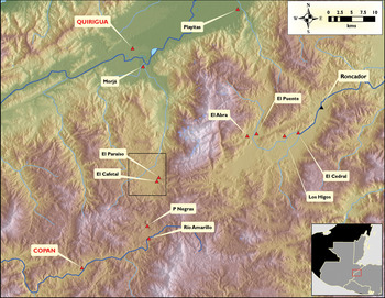
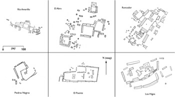
Recent research at the Classic period Maya center of Copan, Honduras (Figure 1) combines with investigations elsewhere in the Maya Lowlands (see, for example, Golden et al. Reference Golden, Scherer, Muñoz and Vásquez2008) to highlight a previously underappreciated diversity of administrative and integrative strategies in the Maya area. This diversity suggests that among the Classic period Lowland Maya, political authority was derived and subsequently deployed in distinctly local ways.
Select Late Classic period (a.d. 200–900) archaeological sites in the Copan region. The geographic distribution of many of these sites suggests that pairings similar to those documented in the El Paraíso Valley may have been widespread in the region.

As the southeastern-most of the large Classic period Maya capitals, the Copan kingdom stands apart from other Maya centers in many ways. It is geographically distant, it is known for a nearly in-the-round sculpture style unique among the Classic period Lowland Maya, and its material culture—in particular its pottery—differs stylistically and technologically from objects produced at other contemporary Maya centers. These distinctions most likely spring from Copan's position as a frontier settlement. Its sphere of influence served as an informal and permeable boundary between Maya groups to the north and west, and non-Maya groups to the south and east (Lothrop Reference Lothrop1939; Pahl Reference Pahl1977, Reference Pahl1987; Robinson Reference Robinson1987; Urban and Schortman Reference Urban and Schortman1986).
The southeastern Maya area has long been recognized as a borderland (Anderson Reference Anderson1991; Andrews Reference Andrews and Hammond1977; Bohannan and Plog Reference Bohannan and Plog1967; Canuto Reference Canuto2002; Donnan and Wilson Reference Donnan, Wilson, Donnan and Wilson1994; Manahan and Canuto Reference Manahan and Canuto2009; Schortman Reference Schortman, Urban and Schortman1986; Urban and Schortman Reference Urban and Schortman1986; Schortman et al. Reference Schortman, Urban and Ausec2001; Sharer and Traxler Reference Sharer, Traxler and Sachse2006; Sheets Reference Sheets, Adams and Macleod2000) between the ethnographically known Ch'olan Mayan speakers to the north and west (Guatemala and Belize) and the Lenca region to the south and east (central Honduras and eastern El Salvador). Differences in site plan, construction techniques, architectural embellishment, use of space, and portable material culture suggest that these cultural differences extend into the past.
Given recent research, it is clear that Copan's Classic period polity began with a fifth century a.d. incursion of Peten-based Mayan speakers into southeastern Mesoamerica (Bell et al. Reference Bell, Canuto and Sharer2004; Fash and Fash Reference Fash, Fash, Carrasco, Jones and Sessions2000; Sharer et al. Reference Sharer, Traxler, Sedat, Bell, Canuto and Powell1999, Reference Sharer, Sedat, Traxler, Miller, Bell, Andrews and Fash2005; Stuart Reference Stuart, Carrasco, Jones and Sessions2000). This interloping group of Lowland Maya established several ruling “houses” throughout the area that drove the ascendance of sites like Copan and Quirigua during the Early Classic period (Bell et al. Reference Bell, Canuto and Sharer2004). It is important to note, however, that these elites from the Maya Lowlands entered into an already inhabited and culturally diverse landscape. Therefore, any model explaining the rise of Copan's Classic period dominance must consider how a Lowland Maya elite ruling house gained prominence and eventually dominion in a complex, fully occupied landscape. Copan rulers were required to confront and address this regional diversity throughout the Classic period, and developments in the El Paraíso Valley provide insight into the strategies Copan rulers marshaled to meet the administrative challenges posed by heterogeneous populations.
Such questions relate specifically to the composition, occupation, and subsequent management of Copan's hinterland rather than to the development of its polity center. Since research focused on Copan's passel of secondary centers proves relevant to this issue, this paper focuses on the development of two such hinterland centers. They are both located some 30 km northeast of Copan, in the El Paraíso Valley, which has been the focus of nine field seasons of archaeological research conducted by the Proyecto Arqueológico Regional El Paraíso (PAREP) under the direction of Ellen E. Bell and Marcello A. Canuto.
Investigations in the El Paraíso Valley, on the eastern edge of the Copan kingdom, suggest that, in the mid-seventh century a.d., Copan rulers established an outpost, centered at the site of El Paraíso, less than 1.5 km northeast of a pre-existing and long-lived autochthonous settlement, centered on the site of El Cafetal. In the same vein as enclave communities inserted into hostile territories by Inca rulers (Murra Reference Murra1980:177–178), El Paraíso residents appear to have worked to safeguard the economic and political interests of Copan elites in the region throughout the Late Classic period (a.d. 650–800). In this way, Copan elites employed a dynamic, region-specific administrative strategy in which they eschewed programs of cultural assimilation in favor of negotiating across (and thereby reinforcing) cultural boundaries and identities. This strategy seems to have been effective, in large part, because it acknowledged and capitalized on the multiplicity of social identities in the region and their integral importance to polity-building endeavors.
Combined with the available evidence from Copan's other secondary centers, including Quirigua (Ashmore Reference Ashmore2007; Schortman Reference Schortman1993; Sharer Reference Sharer, Boone and Willey1988), Los Higos (Nakamura et al. Reference Nakamura, Aoyama and Uratsuji1991; Pahl Reference Pahl1977), El Puente (Nakamura et al. Reference Nakamura, Aoyama and Uratsuji1991), El Abra (Nakamura et al. Reference Nakamura, Aoyama and Uratsuji1991), La Union (Sanchez Reference Sanchez2003), and Río Amarillo (Canuto Reference Canuto2002; Saturno Reference Saturno2000), PAREP's data suggest that the Copan dynasty gained and maintained control of its domain during the Classic period by using a strategy focused on the exacerbation and maintenance of difference among diverse regional populations rather than their wholesale assimilation into the Copan body politic. Research conducted to date suggests that the multiethnic composition of the region and its location at interstitial nodes within an active interaction zone required strategies that recognized, addressed, neutralized, or even exploited a wide range of salient social identities, including distinct ethnicities and linguistic affiliations. If correct, this interpretation highlights the relevance of identity formation to strategies of political integration among the Classic period Maya.
EL PARAÍSO VALLEY, COPAN, HONDURAS
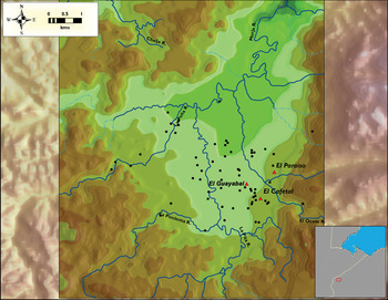
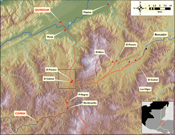
The El Paraíso Valley is an intermontane valley in the Sierra del Espíritu Santo range of western Honduras carved out by several rivers which drain northward into the Motagua River watershed (Figure 2). It is separated from the neighboring watershed of the Copan/Río Amarillo valleys to the southwest and the Chamelecon watershed to the east by low passable ranges. Situated only 27 km northeast of Copan, 30 km south of Quirigua, and 20 km west of El Puente, the valley's sites were in a critical position to integrate not only Copan's northerly route through Quirigua to the rest of the Classic Maya cities in the southern lowlands, but also its easterly route through El Puente to its non-Maya neighbors in central Honduras.
Pre-Columbian settlement in the El Paraíso Valley, Department of Copan, Honduras. The Late Preclassic period (400 b.c.–a.d. 100) center of El Guayabal joins the paired Classic period (a.d. 200–900) centers of El Cafetal and El Paraíso in the southeastern quadrant of the valley. Settlement dating from the Late Preclassic through the end of the Classic period is dispersed throughout the valley beyond these centers, with the greatest settlement density found in the well-drained southern portion of the valley.

History of Investigation
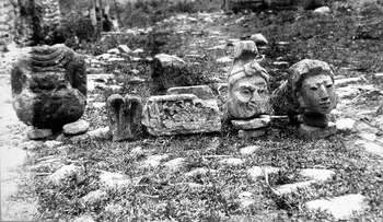
Many of the currently known archaeological sites in the El Paraíso Valley were reported over a century ago by the first archaeologists to carry out substantial investigations at Copan and were subsequently the focus of short visits by several scholars (Lothrop Reference Lothrop1926, Reference Lothrop1939; Morley Reference Morley1917, Reference Morley1920; Sapper Reference Sapper and Parker1897, Reference Sapper1898; Yde Reference Yde1936, Reference Yde1938). In 1895, the German geographer Karl Sapper produced the first map of the El Paraíso site. Roughly two decades later, Sylvanus G. Morley reports finding at El Paraíso “a fairly large site in 1914” (1920:6, Footnote 2) and a Peabody Museum Central American Expedition team led by Samuel K. Lothrop in 1917 photographed fragments of volcanic tuff architectural sculpture found at the site (Lothrop Reference Lothrop1926:159–160, Figure 51) (see Figure 3). Based upon his examination of the sculpture, Morley suggested that El Paraíso shared closer artistic ties with Copan than Quirigua (1920:381, Footnote 2) and that the site had been established by Copan in the Late Classic period as part of a region-wide colonizing endeavor (1920:431).
El Paraíso sculptural pieces (image courtesy of the Peabody Museum of Archaeology and Ethnology, Harvard University, 58-34-20/64363). These fragments of mosaic sculpture were initially photographed by the expedition under the direction of Samuel K. Lothrop in 1917. They had been transferred to the El Paraíso cabildo by the time some of them (including the trough stone and anthropomorphic heads) were photographed by Franz Blom in 1935 as part of the Tulane University-Danish National Museum expedition reported by Yde (Reference Yde1938:45–47, Figures 20–24). Much smaller fragments sculpted of the same material in the same style have been found in PAREP excavations (see von Schwerin [2010] for details); the current whereabouts of the sculpture reported by Morley, Lothrop, and Yde are unknown.

Despite H.W. Price's initial recognition of El Paraíso's uniquely preserved architecture (letter to C.P. Bowditch, January 1, 1892; summary housed in the Archives of the Peabody Museum, Harvard University), the first detailed description of the site's buildings was published by Jens Yde (Reference Yde1936, Reference Yde1938) in his report of the Tulane University–Danish National Museum joint expedition to Central America in 1935. He also published photos that show, in much poorer condition, the same sculptural pieces initially documented by Morley and Lothrop. Yde (Reference Yde1938) reported that, by the time of his visit, these pieces had been removed from the site and were stored in the town's central municipal building.
Following these visits, the valley did not again become the focus of archaeological investigations until regional surveys conducted as part of the Proyecto Arqueológico Copan (PAC I) brought Kurt Long and William L. Fash to El Paraíso in 1979. This team discovered, mapped, and placed test excavations in a second, previously unreported Late Classic valley center located only 1.5 km southwest of El Paraíso that became known as El Cafetal (Fash Reference Fash and Baudez1983b; Long Reference Long1979; Vlcek and Fash Reference Vlcek, Fash, Urban and Schortman1986).
In 2002, PAREP began a long-term, valley-wide research program that has included reconnaissance, settlement survey, topographic mapping, test and intensive excavations, soil chemistry analysis, and detailed studies of the Copan-style mosaic architectural sculpture and portable material culture, including pottery, within the valley (Bell and Canuto Reference Bell and Canuto2006, Reference Bell and Canuto2007, Reference Bell and Canuto2008, Reference Bell and Canuto2009, Reference Bell and Canuto2010, Reference Bell and Canuto2011; Bell et al. Reference Bell, Canuto and Ramos2001; Canuto and Bell Reference Canuto and Bell2003a, Reference Canuto and Bell2003b, Reference Canuto and Bell2004a, Reference Canuto and Bell2004b, Reference Canuto and Bell2005, Reference Canuto and Bell2008; Canuto et al. Reference Canuto, Bell and Ramos2002).
Culture History
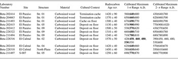
PAREP has recovered evidence for occupation in the valley dating to the beginning of the Middle Preclassic period (400 b.c.) and continuing through the tenth century a.d. Although occupation started a few centuries earlier, by approximately 300 b.c., the El Paraíso Valley was the seat of the largest Preclassic site in northwestern Honduras, El Guayabal (see Figure 2). This site consisted of earthen mounds arranged informally around a plaza anchored by an 8–10 m-high earthen structure (see Cagnato [2008] and Sharer et al. [2011] for more details). El Guayabal was the largest site of a three-tiered Late Preclassic settlement hierarchy within the valley, suggesting that it was the capital of a regional sociopolitical unit (Bell and Canuto Reference Bell and Canuto2008; Cagnato Reference Cagnato2008; Weber Reference Weber2008). Following this early florescence in the region, it appears that the valley's population declined after the Late Preclassic period, as PAREP has recovered little evidence for large-scale constructions or widespread occupation during the Protoclassic and Early Classic periods (ca. a.d. 1–400). For the Classic period, ceramic and radiocarbon data (Table 1) suggest that by a.d. 500, population in the valley had begun to grow again, reaching its peak in the seventh and eighth centuries, followed by a general abandonment of the valley during the tenth century.
Summary of radiocarbon data from PAREP excavations of Classic period contexts*

* Radiocarbon ages have been calibrated using program CALIB (v. 4.2) (see Stuiver and Reimer Reference Stuiver and Reimer1993; Stuiver et al. Reference Stuiver, Reimer, Bard, Beck, Burr, Hughen, Kromer, McCormac, van de Plicht and Spurk1998).
El Cafetal
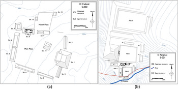
PAREP's chronometric data suggest that Classic period occupation first concentrated in the southeastern portion of the valley bottomland, approximately 1 km south of the then-abandoned Preclassic center of El Guayabal. Within a century, this settlement had coalesced into the rural center of El Cafetal (Figure 4a), which consisted of monumental architecture, residential buildings, and public spaces. At its peak as a rural center, El Cafetal was organized around two open plazas, the Main Plaza and the North Plaza. Long, low range structures formed the eastern, southern, and western sides of the Main Plaza, while the northern margin was formed by large pyramidal buildings. The pyramidal structures appear to have been constructed for ritual or ceremonial use, while the range structures were most likely elite residences. The site's principal ceremonial building, Structure 1, measured 11–13 m in height and dominated the landscape on the eastern side of the center.
Marked differences in site plan and the use of space are clearly visible at the two large Classic period centers in the El Paraíso Valley. (a) El Cafetal exhibits an open site plan with large plazas that can be entered from multiple directions, while (b) buildings at El Paraíso cluster tightly around sunken courts with few access points.

Excavations have demonstrated that the site's Classic period occupation can be divided into two major construction phases. Calibrated intercept dates associated with the earlier construction phase range from a.d. 450–640 (Table 1; Beta-228316, 228318, 202410). According to the ceramic and radiocarbon data, El Cafetal's second phase of construction dates to the latter half of the eighth century, which saw the expansion of residences approximately 100 m west of the site core in EPV-Site-007 (Table 1; Beta-211497). Although major construction at El Cafetal ends by the ninth century, small concentrations of Terminal Classic and Early Postclassic period ceramics have been recovered from several contexts at the site—principally on the plaza floor surrounding the larger structures of the center and on top of wall-fall that blanketed the summit of one of these buildings (Structure 6). It is likely, therefore, that a small population continued to inhabit the valley for approximately a century after this center's elite families had abandoned it, perhaps conducting small ceremonies at the otherwise deserted center.
El Paraíso
Roughly a century after the settlement at El Cafetal had begun to coalesce, a second center, El Paraíso, was established along the banks of the Quebrada Rosario, approximately 1.5 km northeast of El Cafetal. Built up against a hillside on its eastern flank, the site of El Paraíso is the highest construction in the valley and looks out over lower-lying areas to the west and south. Given the site's location near the modern town, PAREP has not been able to determine the full extent of the settlement surrounding this center. Nevertheless, data suggest that, by a.d. 650, El Paraíso had grown to rival its neighbor's dimensions (Figure 4b). At its height, El Paraíso consisted of at least four sunken courts formed by interconnected platforms that supported a variety of stone masonry buildings, at least two of which (Structure 1 and Structure 9) were decorated with Copan-style mosaic architectural sculpture made of volcanic tuff. The four quadrangular courts formed a small but tightly integrated architectural unit with restricted points of access, dominated on its western side by Structure 1, an 8–10 m tall temple structure that afforded a panoramic view of the entire valley from its summit.
The radiocarbon data from El Paraíso were drawn from three separate buildings, each consisting of several phases of construction. The calibrated intercept dates from each building's earliest construction phase range from a.d. 570–670, while calibrated intercept dates from the last construction phase from each building date to a.d. 690–780 (Table 1). Although the radiocarbon data indicate that the second construction phase lasted almost a century, the associated ceramic data imply that El Paraíso's final architectural renovation corresponds to the reigns of Copan's last two dynasts (ca. a.d. 749–810).
As in the case of El Cafetal, the radiocarbon and ceramic data point to the site's political and demographic decline during the ninth century. But PAREP has also recovered data that suggest El Paraíso was reused by Terminal Classic or Early Postclassic period settlers—this later, final occupation of the site is associated with a calibrated intercept date of around a.d. 900 (Table 1:Beta-202415). During this final phase buildings were left to crumble and, in at least one instance, were reused as makeshift tombs.
Settlement Pattern
El Paraíso and El Cafetal are both located in close proximity to one another in the southeastern portion of the valley. The El Paraíso Valley is one of the largest expanses of open land (ca. 20 km2) in a region dominated by the rugged Sierra de Espíritu Santo mountain range, affording its residents more arable land than the Copan Valley, 30 km distant.
The valley itself, while generally flat in comparison with the rugged mountains that surround it, does include a wide range of geological features that create topographic microzones with varying drainage patterns (Figure 2). Several small permanent and seasonal streams, including the Ocote, Pita, Peña, and Rosario, converge to empty into the Morjá River, swelling this stream before it joins the Motagua to the north. The confluence of these waterways within the El Paraíso Valley is located in the northeastern corner of the valley, where it creates seasonally wet conditions. During the height of the rainy season, portions of this area remain wet for long periods of time, complicating both cultivation and permanent settlement. In addition to the seasonal flooding, the active fluvial landscape observed in the present was also at work in the past, both constraining settlement patterns and altering the post-abandonment landscape sufficiently to obliterate any trace of low-lying settlement. In fact, all of the pre-Columbian settlement documented in the valley to date is located on or above the second alluvial terrace, suggesting either that valley residents, perhaps in deference to the active fluvial regime, chose not to build at lower elevations, or that any settlement located on the first terrace of these streams had long since been washed away or buried by sediment.
Even though El Cafetal is situated on the second alluvial terrace of the Ocote River, its residents were forced to contend with flooding produced by this stream during the occupation history of the center. El Paraíso, in contrast, is located well above the floodplain. Due to the adjacent Quebrada Rosario, however, its residents were also forced to contend with the deleterious effects of an active fluvial landscape. Seasonal flooding of this stream had resulted in the destruction of at least one building, El Paraíso Structure 8, and most likely several others by the time the first published map of the site was made by Sapper in the 1890s. In light of these findings, although certain portions of the valley exhibit drainage patterns more conducive to settlement than others, none was completely free of the potential for water-related complications.
The unstable water regime that impacted valley settlement may also have been a factor in the location, organization, and intensity of cultivation in the valley. The valley is favored with a number of attributes rendering it amenable to the cultivation of agricultural products, including foodstuffs. The large expanse of open valley floor, the high levels of precipitation, and the mild climate all coalesce to allow for multiple cropping in modern times. Indeed, much of the valley floor remains under cultivation or grazing today. The large amounts of water that pass through the valley on an annual basis—both from high rainfall amounts in the valley itself and from waters carried by the streams and rivers that drain the surrounding mountains—increase seasonal agricultural productivity.
Although it is exceedingly difficult to document the extent and nature of cultivation in the past, it is likely that valley residents cultivated much, if not all, of the land suited to such activities. Based on the assessment of cultivable land in the present-day, factoring in the location and extent of Classic period settlement, and taking into account the present day water regimes, it is possible that 60–90% of the valley floor (18–27 km2) might have been available for cultivation in the Classic period. While large portions of the valley may have been suitable for cultivation, it is important to note that based on modern practices, it is also possible that much smaller areas were intensively cultivated, while others were left fallow. Given that much of the arable land in the Copan Valley had been blanketed with dense settlement by the eighth century a.d. (Fash Reference Fash, Urban and Schortman1986; Wingard Reference Wingard and Fedick1996), it is possible that nearby valleys, including El Paraíso, served as “maize baskets” for Copan residents, providing many of the agricultural staples required to sustain the burgeoning population.
Summary
Roughly a century after the initial report of archaeological remains in the El Paraíso Valley it is possible to trace the general culture history of the region, to confirm the valley's high potential for agricultural productivity, and to note that the area was home to a substantial population in both the Late Preclassic and Classic periods. In the course of investigations, PAREP has focused on perhaps the most obvious—and likely most salient—aspect of the El Paraíso Valley's Classic period occupation: it played host to two coeval rural centers, which, despite their propinquity and comparable size, are strikingly different from each other. Put simply, whereas El Cafetal resembles central Honduran sites in plan, architecture, and material culture, El Paraíso is more akin to an elite residential complex from Classic period Copan. In fact, the multitudinous differences between them suggest that during the Classic period distinct groups of people lived side by side within this valley and perhaps throughout Copan's hinterlands.
COMPARING EL CAFETAL AND EL PARAÍSO
To understand the nature and extent of the difference between these two contemporaneous centers, four separate lines of evidence are highlighted: spatial plan, architecture, use of open spaces, and portable material culture. These four data sets inform upon not only the economic wherewithal or political affiliations of valley residents and their leaders, but also on cultural predispositions enacted through daily practice.
As a caveat, it is important to note that comparisons using necessarily normative archaeological data often draw overly stark distinctions among sites or their inhabitants. In fact, these comparisons often fail to capture how shared routines of daily life, the practice of social negotiation, and the incidence of factional resistance can mitigate differences in the material conditions of social life (Bourdieu Reference Bourdieu and Nice1977). Nevertheless, it remains possible to consider differences between El Cafetal and El Paraíso as indicative of some type of disjunction between their respective inhabitants. As studies of identity have suggested (Barth Reference Barth1969; Díaz-Andreu et al. Reference Díaz-Andreu, Lucy, Babić and Edwards2005; Jones Reference Jones1997), this disjunction is nowhere more apparent than in frontier or borderland zones where distinct groups living side by side find it necessary to heighten and highlight their differences to clearly mark group affiliation. The question of whether this contrast results from differential access to resources, differences in the socioeconomic function of the two sites, the political status of elite leaders, or the aesthetic and cultural predispositions of their residents remains open and are discussed below.
Spatial Plans
As has long been noted, the construction of the built environment shapes and is shaped by the activities conducted within it (Rapoport Reference Rapoport1969, Reference Rapoport1982, Reference Rapoport and Kent1990, Reference Rapoport and Ingold1994). Within these functional requirements and constraints, and taking into account the local environment, the structures and open spaces that form human settlements are also shaped by the practices, traditions, and aesthetics of the groups who build and reside within them. Differences in settlement pattern, site plans, and architectural form, therefore, provide invaluable insights into the affiliations and enacted salient social identities of their builders and residents. In this vein, we compare the location and spatial plans of both El Cafetal and El Paraíso to explore social diversity within the valley.
Location
Differences between the two centers are readily apparent, beginning with their location within the El Paraíso Valley. Given the ample size of this intermontane valley, it is surprising that both El Paraíso and El Cafetal are crowded into a small segment of the flat land on its southeastern edge. We suggest several possible explanations for this settlement pattern: (1) other portions of the valley may have been subject to periodic or seasonal flooding, (2) valley paramounts may have wished to reserve as much land as possible for cultivation, (3) a strong presence in this portion of the valley may have been required to dominate regional trade routes that passed through the valley, and (4) the center of El Paraíso, founded after the center of El Cafetal was well established, may have been deliberately located near (and above) the site of El Cafetal as part of a strategy of domination.
Maintaining access to and control of trade routes into, out of, and through the El Paraíso Valley may have been instrumental in the placement of both El Cafetal and El Paraíso. GIS-based least-cost path analysis of routes between the two large Maya settlements that dominated the region in the Classic period, Copan and Quirigua, indicate that all of the most accessible routes between the two centers pass directly through the El Paraíso Valley (Figure 5). Given that the majority of these routes enter/exit the valley through its southeastern corner, this region is a logical place from which to oversee or control access to and travel along these routes. The tallest structures at both El Paraíso and El Cafetal afford clear views along these routes, with Structure 1 at El Cafetal providing the most extensive viewshed to the south and El Paraíso Structure 1 providing the best viewshed to the north. The placement of the site of El Paraíso in the foothills above the valley floor also provided unobstructed views of the majority of the valley flatlands. Depending on the height of trees and other vegetation in the valley during the Classic period, paramounts at El Cafetal may have had portions of their view of the valley floor obstructed, while the residents of El Paraíso would have had clear views from their perch in the foothills.
Possible routes through the Copan kingdom. Least-cost path analysis suggests that the most efficient of these routes passed through the El Paraíso Valley, making it a key node in networks throughout the region.

If control of these trade routes into and out of the valley was a factor in the placement of the two centers, it is interesting to note that El Cafetal, the earliest Classic period center founded in the valley, was placed on the valley floor while El Paraíso, built later, was placed in the foothills along the southeast side of the valley. If those who built El Paraíso were directed as much by the cultural and political environment as by the physical geography, then several possibilities present themselves: El Cafetal residents were uninterested in or unable to prevent El Paraíso architects from placing the new center in the southeast corner of the valley; El Paraíso may have been founded with the full approval and cooperation of El Cafetal paramounts; or El Paraíso may have been located close to El Cafetal with the explicit intent of intimidating and dominating that site, as well as controlling the trade routes into and out of the valley. Whatever the case may have been, the placement of El Paraíso in the foothills above the valley floor afforded its paramounts not only a clear view of routes into and out of the valley, but also a commanding vista over the valley itself, including the site of El Cafetal. The entire site of El Paraíso, therefore, loomed large on the horizon above even the tallest structures at El Cafetal.
Access
The placement of each center also created different access patterns. El Cafetal, like all other documented settlements in the valley, is situated on the second alluvial terrace above the adjacent Ocote River. At El Cafetal, however, the level of this terrace is quite low, dropping in some areas to less than 1 m above the first terrace. This low elevation has the effect of bringing the center to the level of the valley floor, removing any topographic boundaries to entry (Figure 4a). Spatial organization within El Cafetal also facilitated access, creating a generally informal organization of open space in which the large, open plazas were entered through wide gaps between structures.
Each of El Cafetal's 14 large structures in the site core was a free-standing building, with all sides accessible. The two large, public spaces within the site, the Main Plaza to the south (formed by Structures 1–11) and the North Plaza (formed by Structures 8, 9, 12, and 13), are spacious enough to accommodate large crowds, and soil analysis suggests that the open spaces were used both extensively and intensively (Canuto et al. Reference Canuto, Charton and Bell2010). This accessibility was extended through the inverse viewshed that El Cafetal's location on the valley floor provided—activities carried out within both plazas were clearly visible from the foothills that surround the valley, including from El Paraíso. This physical and visual access reinforced one another to underscore the ethos of openness that appears to have been an important aspect of El Cafetal spatial organization.
El Cafetal also exhibits a dynamic rather than a static pattern, with renovations carried out in the mid-eighth century a.d. significantly altering the site plan, with, it may be argued, the express intention of emphasizing and improving accessibility. This renovation saw the construction of Structures 12 and 13, informally designated as “gateway buildings” that marked the expanded northern entrance of the center and defined the northern edge of a cobble-paved area that increased open space within the center by at least 25%. This renovation also saw the construction of both the final version of Structure 8 and Structure 9, a low wall and stair that formalized and emphasized the entryway into the North Plaza, drawing attention to the place and process of entry into the site core. This ethos of accessibility stands in stark contrast to patterns at El Paraíso.
El Paraíso's location high above the valley floor provided an excellent vantage point for its paramounts inside the center and it prevented anyone outside from seeing activities carried out in and around the buildings that formed it. The construction may best be described as an acropolis (Figure 4b), a large complex whose sum effect is to create an artificial hill upon which its buildings are perched. This artificial construction also includes valleys—sunken courts—around which the buildings are arranged and in which regal-ritual ceremonies and other activities were likely conducted. Of the four courts defined within El Paraíso, two (Patios 1 and 4) were predominantly formal, public spaces, while the remaining two (Patios 2 and 3) were likely elite private areas. Even the public spaces, however, are far smaller and far more difficult to access than their counterparts at El Cafetal.
Unlike El Cafetal, there are few ways to enter the open spaces at El Paraíso; all of the patio corners are closed, many of the adjacent structures abut one another, and there are few clear stairways designed to facilitate the flow of foot traffic into and out of the open spaces and buildings. The access that is possible from the valley floor requires an uphill climb, not only up the natural rise of the foothills on which the center is situated, but also up the imposing stone terraces that form its western façade.
The organization of the site orients all of the structures inward toward the four sunken courts, causing, in effect, the inhabitants to turn their backs to the rest of the valley. While the mosaic architectural sculpture adorning the western façade of Structures 1 and 9 would have been visible from the valley floor, the open doors of the superstructures would not. This imposing presence may have been designed to communicate a message of aloofness, detachment, and domination over the valley while also drawing on pan-Mesoamerican practice, symbolism, and tradition to assert dominance by building the highest structure in the valley. This sense of remoteness was underscored by the volcanic tuff imported from a source outside the valley that was used in the construction of the three-dimensional mosaic stone sculpture that decorated the superstructure façades of its largest and most visible buildings. These sculptures, along with the rectilinear arrangement of the buildings and the portable material culture, drew attention to El Paraíso's ties to Copan and the rest of the Maya world.
All of these elements combined to make El Paraíso a formidable space—it was difficult to enter, it loomed above the valley, it was constructed in a foreign style of materials brought in from other places, and its residents used imported objects almost exclusively in their daily lives. All of these elements contribute to making El Paraíso a place removed—a place apart. It was a distant, inaccessible redoubt whose residents lived within the valley and yet apart from it, marking it as a disembedded center.
Proxemics
The experience of space within each center is also distinct. Building on the differences in the location of each settlement, access patterns and the spatial proxemics within El Cafetal and El Paraíso must also have been quite dissimilar. The organization of space within El Cafetal—with its expansive public spaces, open, accessible corners, and large residential buildings with undifferentiated interiors—seems to have lent itself to an ethos of accessibility. The site itself faces out onto the valley floor, and the refurbished entryway defined by Structure 9, with Structure 12 and Structure 13 acting as gateway buildings, worked to pull people into the site. The undifferentiated spaces within the site suggest that residents (and visitors) lived with few fixed barriers dividing them.
Spatial patterning within El Paraíso, in contrast, is built around the concept of division and perhaps even exclusion. The placement of El Paraíso in the foothills above the valley with the rear façade of the principle structure looming large separates and distances the center from the rest of the valley. The high terraces, closed corners, and sunken patios create firm, fixed spatial distinctions within the site core, and differences in elevation combine with fixed architectural features like walls, steps, and terraces to create three-dimensional boundaries and divisions. Interior spaces within El Paraíso structures also reinforce these distinctions, with built-in fixed features like interior walls and raised stone benches creating set, permanent boundaries within the rooms. Again, while it is impossible to make a precise assessment of proxemics in the Classic period, spatial patterning within the center suggests that El Paraíso residents lived in spaces with a large number of spatial divisions, perhaps putting a premium on privacy and the distinction between public and private space, space inside and outside the center, and those who were permitted to frequent each.
Summary
The spatial plans of the two large centers in the valley, El Cafetal and El Paraíso, demonstrate marked differences between them. El Cafetal is located on the valley floor, its corners are open and provide multiple pathways through which the center could be entered, and spatial patterning in the center suggests an open ethos. El Paraíso, in contrast, is located in the foothills above the valley floor, its sunken courts are closed on all corners and provide few access routes, and spatial patterns within the center suggest an emphasis on division and privacy. The location, access patterns, and proxemics within each center suggest that they were occupied by people with different expectations regarding the organization and use of space.
Architectural Styles
Building on the distinctions between and within spatial plans discussed above, El Cafetal and El Paraíso differ both quantitatively and qualitatively along almost every axis of architectural comparison. Differences in construction techniques, spatial organization, and architectural embellishment between these two sites reflect different architectural traditions, styles, and aesthetics extant during the several centuries of construction in the Classic period.
Technical attributes
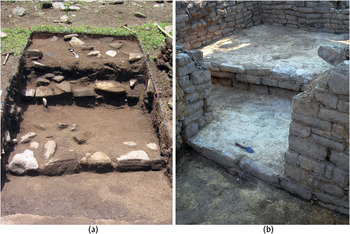
While there are some basic similarities that are consistent with architectural patterns throughout southeastern Mesoamerica in the Classic period, including the placement of roofed superstructures atop solid substructures, builders at El Cafetal and El Paraíso appear to have used significantly different construction techniques to achieve similar goals (Figure 6). While both sites include raised platforms, stable structures, walkable surfaces, and drained open areas, these differ markedly in their construction technique and finishes.
Construction techniques, architectural style, and structure embellishment vary dramatically between centers in the El Paraíso Valley. Many of the structures built at (a) El Cafetal before a.d. 750 included unembellished, perishable superstructures atop low, terraced, earthen substructures faced with unquarried stone, while (b) early structures at El Paraíso included superstructures made of well-shaped local stone embellished with limestone plaster and fitted out with interior benches and curtain holders.

At El Cafetal, the early phase of construction consists of platforms with façades of slightly faced stones or cobbles, superstructure walls of small cobbles or wattle-and-daub construction, and roofs of thatch. In terms of fill, all structures exhibit a dry-laid clay-and-cobble mixture that did not stand the test of time well. Excavations demonstrate that some buildings slumped even while they were still in use, requiring quick alterations and modifications. During El Cafetal's final phase of construction, new and expanded residential and shrine structures (Structures 5, 6, 7) established an elite residential, ritual, and administrative zone in the northwest corner of the Main Plaza. The buildings that formed this complex introduced new architectural features including cut stone masonry, interior furnishings, and plaster. Finally, there was never a formal water drainage system constructed at the site—the major open spaces generally followed the natural contours of the terrain. In fact, much of the water would likely have percolated directly into the plaza floors rather than having been shunted off to the Ocote River or another outlet.
At El Paraíso, the buildings are far more elaborately decorated and constructed than those at El Cafetal, especially in comparison with El Cafetal's initial phase buildings. Structures at El Paraíso fall solidly within the canons of elite southeastern Maya architecture, and many appear to have been modeled on elite residences in and around Classic period Copan. The elite residences that surround Patios 1, 2, and 3 were built of cut stone masonry. In some cases, the façade above the medial molding appears to have been built entirely of imported volcanic tuff, with the volcanic tuff cut blocks being used to seat and surround Copan-style mosaic sculpture carved from the same stone. The substructure platforms were built using a fill-bin technique that involved constructing a series of intersecting cobble walls that created a lattice of approximately 8 m3 cells filled with small- to medium-sized cobbles. Even though the fill had no binding material, the fill-walls proved effective stabilizers. In some smaller buildings at El Paraíso, the fill was wet-laid and rich in clay, reminiscent of the fill found in the Copan Acropolis (Sharer et al. Reference Sharer, Traxler, Sedat, Bell, Canuto and Powell1999). El Paraíso also included a far more elaborate drainage system than that seen at El Cafetal. Drain stones (including the elaborately carved stone photographed by Lothrop in 1917 and additional uncarved examples recovered in PAREP excavations) funneled water off the masonry roofs of the large structures, and a floor-level masonry drain-head allowed water to flow off the Patio 1 plaster floor through a subplatform drain that extended at least 30 m beyond the confines of Patio 1 to unused open areas south and west of the site. The floors were also inclined by approximately 2o to ensure that water drained quickly.
Building types and spatial organization
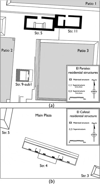
Each center also included distinct building types and arrangements of interior spaces (Figure 7). While the differences among these buildings are, of course, linked to the activities carried out in each, some of the observed distinctions are also linked to differences between the two centers and their residents.
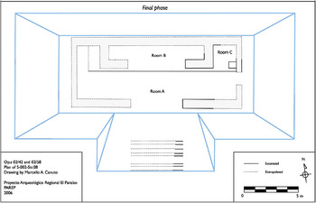
(a) Residential structures at El Paraíso include extensive fixed features and embellishments throughout the occupation of the site, while (b) early buildings at El Cafetal are characterized by open interior spaces.

During El Cafetal's early phase, the center was composed of two main building types: range structures (used as elite residences and administrative buildings) and pyramidal substructures with rectangular superstructures (used as shrines or temples). The range structures—buildings more than twice as long as they are wide—were topped by freestanding superstructures with cobble and lightly shaped stone foundations that supported perishable wattle-and-daub walls and perishable roofs, most likely made of thatch. The interior spaces within each of these superstructures are, for the most part, undifferentiated by fixed architectural features.
For instance, Structure 4's single summit building measured approximately 120 m2 (33 × 3.5 m) with multiple doorways defined by cobble masonry door jambs placed approximately 4 m apart. In its initial construction phase, this superstructure appears to have had no internal divisions of stone masonry, although it is possible that semipermanent features such as curtains or wattle-and-daub wall stubs could have created rooms. Over several construction phases, the interior of the building was partially partitioned as two small interior rooms measuring 6 m2. Their diminutive size, however, suggests they served some specialized function such as storerooms or shrines. An expansion of the residential space was achieved by widening the platform summit with an addition to the south that gave the platform a broad “T” shape. In the analogous cases of Structures 2, 3, and 11, the superstructure includes a single long, open room that appears to have been accessed by a single door at the center of the long axis that was reached by ascending the low terraces forming the substructure.
The early part of the Classic period at El Cafetal was also characterized by pyramidal substructures with rectangular shrine buildings. Like the residences, these buildings included few internal divisions. For instance, the superstructure atop Structure 10 appears to have been formed by foundation walls built of lightly shaped stones that supported perishable wattle-and-daub walls and a perishable thatch roof but included no distinct interior rooms. Lacking fixed dividers, the Structure 10 superstructure provided a relatively small (8 × 8 m), open interior space. Despite being almost completely destroyed, excavations suggest that Structure 1's superstructure, the largest pyramidal building at El Cafetal, was also characterized by a relatively small, square or rectangular open space with no permanent internal divisions.
During El Cafetal's later construction phase, two additional building types were added to the center's construction repertoire: (1) long, low, stepped structures used to define the boundaries (including entrances) of the monumental open spaces within the center, and, (2) a specialized administrative building with features never before seen at El Cafetal. The boundary-defining structures (Structures 9 and 14) were relatively simple constructions, consisting of steps and foundation lines of small cobbles and lightly shaped stones that, in some instances, supported wattle-and-daub walls. The specialized administrative structure, however, provides a clear example of a radical departure from earlier construction practices; the renovation of Structure 8 in the mid-eighth century a.d. produced a building entirely unprecedented at the site (Figure 8). The interior of the structure measured 72 m2 (15 × 4.8 m) with the space divided into a front room extending along the entire length of the building and three small, raised interior rooms at the back of the structure. The entire building was also embellished with a layer of white stucco. This floor plan is strikingly similar to those of Copan's Structure 10L-22 (Fash Reference Fash1992; Maudslay Reference Maudslay1889–1902; von Schwerin Reference von Schwerin2011) and Quirigua's Structure 1B-5 (Ashmore Reference Ashmore2007; Sharer Reference Sharer1990), suggesting that the activities carried out within each might also have been similar. Two adjacent elite buildings, Structure 6 and Structure 7, were also built of carefully shaped cut blocks and embellished with white stucco, suggesting that the entire northwest corner of the Main Plaza was renovated as part of a single program.
Structure 8, built after a.d. 750, represents the final phase of El Cafetal and marks a significant departure from earlier construction patterns at the site. This structure is built of well-quarried stone masonry embellished with limestone plaster and includes several interior rooms arranged on multiple levels (floors of Rooms B and C are approximately 0.8 m higher than that of Room A). In contrast to similar buildings at El Paraíso, however, no architectural sculpture was found in association with El Cafetal's Structure 8.

At El Paraíso, in contrast, the central ceremonial building, Structure 1, appears to have been constructed using techniques not seen elsewhere in the valley. This building, which is thought to have served as the setting for ritual and administrative activities, included a large stone substructure that was rebuilt multiple times, a columned superstructure, abundant stucco on the walls, well-formed plaster floors, and mosaic architectural sculpture in the Copan style.
The El Paraíso elite residences follow a Copan template in their spatial plan, with stone-walled residential structures set on low terraced and stepped platforms. They are characterized by small rooms delimited by multiple interior walls, curtain holders, and benches. Rooms were generally no larger than 30 m2 (Structure 5); and some were as small as 7 m2 (Structure 11, Room B). Rooms were arrayed into linear or L-shaped contiguous patterns and were separated by interior walls and accessed through narrow (1.2 m) doorways. The door-jambs were often adorned with integral curtain holders that would have made it possible to secure doors in place and provide privacy in differentiated interior spaces. The multiroomed residence gives the impression that each distinct room had a specific function. Moreover, expansion of residential spaces appears to have been “modular”—that is, new rooms were added to already existing structures.
The majority of the interior space in most of the elite residential rooms documented to date was consumed by large, raised stone benches covered with a thick layer of plaster. In some cases (including Structure 5) the front face of these benches is decorated with stone moldings. There is no clear indication—in the form of preserved features or vault stones—that any of the buildings at El Paraíso included vaulted roofs; it is more likely that the roofs were made of stone, timber, or thatch. While reports that the roofs of some structures at El Paraíso remained intact reached Peabody excavators at Copan in the 1890s (letter from H.W. Price to C.P. Bowditch, January 1, 1892; summary housed in the Archives of the Peabody Museum, Harvard University) no intact roofs remain at the site today.
Each of the centers appears to have the types of buildings necessary to complete the full range of activities—residential, ritual, and administrative—associated with regional centers of power. While the buildings at the intrusive center of El Paraíso are more elaborately decorated, it is the longer-lived autochthonous center of El Cafetal that appears to have a greater variety of building types. It is important to note that two of the four building types identified at El Cafetal—a specialized administrative building and boundary defining structures—were built as part of a large renovation program in the mid-seventh century. This suggests that the activities carried out at the center may have shifted at this time.
Architectural embellishment
A final axis of architectural distinction between the two secondary centers involves the different forms of embellishment applied to buildings. At El Cafetal, surfaces were earthen or cobble-paved, and building façades were generally covered in daub. Some of the buildings built in the latter construction phase were covered in a stucco finish and had plasters floors. Excavation found no evidence of paint or architectural sculpture embellishing any of the center's buildings, even the late ones. A few pieces of architectural sculpture, made from volcanic tuff, were found at El Cafetal. However, they appear to have been broken and removed from their original location, probably El Paraíso.
At El Paraíso, architectural embellishment took several forms: stucco finish on floors, building façades, platform summits, and stairs; red paint on building façades; and architectural sculpture. In fact, the abundance of volcanic tuff blocks found in the wall-fall surrounding Structure 1 suggests that the entire façade of the Structure 1 superstructure was constructed of volcanic tuff and that these cut blocks served to seat Copan-style mosaic sculpture. Moreover, evidence of stucco, plaster, and volcanic tuff sculpture was associated with even the earliest phases of construction.
At El Paraíso, PAREP excavations have recovered 54 pieces of sculpture in addition to those recorded by Lothrop in 1917 (Figure 3). These pieces may be divided into two broad iconographic categories; one that involves facial elements of a monster mask and mountain foliage, and a second that consists primarily of representations of the human body, such as heads, a bust, and feet, along with associated costuming.
The first set of pieces is primarily associated with Structure 1 and its multiroom summit building that would likely have been visible throughout the valley. Preliminary analysis conducted by von Schwerin (Reference von Schwerin2010) suggests that the sculpture fragments from Structure 1 include eyes, a snout, a long curving nose or tongue, and vegetal imagery. These elements suggest that two large, but not identical earth monster (witz) masks once decorated the upper façade of this building. Such masks are common at Copan from a.d. 650 (reign of Ruler 12) onward—a fact consistent with the radiocarbon dating of this structure (see Table 1). In fact, these decorations are similar to those on a contemporary ritual and administrative building at Río Amarillo (Saturno Reference Saturno2000).
Curiously, there are fresh water springs located at the bases of the main structures at both Río Amarillo and El Paraíso. The spring at El Paraíso might explain the association of this structure with several drain-stones—one carved with underworld imagery. The iconography of these masks coupled with the spring that lies below Structure 1 marks the building as a “water mountain” temple, an important designation in the greater Copan kingdom (Davis-Salazar Reference Davis-Salazar2003; Fash Reference Fash, Andrews and Fash2005; Saturno Reference Saturno2000; von Schwerin Reference von Schwerin2010). It seems likely that large “water-mountain” temples were being constructed throughout the Copan kingdom at various hinterland centers, perhaps in recognition of their affiliation to Copan and their status as important settlements.
The second set of sculptural pieces is associated with Structure 9, a long rectangular building located in Patio 3. Much of the building has been destroyed by recent activity, so its final form cannot be accurately deduced. However, excavations suggest that it would have been similar in scale to Structure 9N-82 from Las Sepulturas, Copan (Baudez Reference Baudez1983; Webster Reference Webster1989). As an elite residence, it was decorated by large human figures dressed in elite garb that includes decorated sandals, which are in the style of the elite figures also depicted on the façades of structures at the Las Sepulturas and Cementerio groups at Copan (von Schwerin Reference von Schwerin2010). Furthermore, the figurative themes of this set include sky band motifs also found at Copan.
Summary
A detailed analysis of the architecture of these two centers indicates that the differences between them extend far beyond the spatial arrangement of their respective buildings. Rather, the manner in which their buildings were constructed, their interior spaces were organized, and their surfaces were finished and decorated further highlights the extent to which El Cafetal and El Paraíso differed. Moreover, considering that the arrangement of residential space and decoration derive from cultural predispositions, it would seem plausible to suggest that these dissimilarities signal profound cultural differences between the populations of these two centers.
At El Cafetal, the construction techniques, the T-shaped rectangular cobble-masonry platform of Structure 4, and the multiroomed wattle-and-daub superstructures suggest an overall architectural and residential complex found most commonly at non-Maya sites in the Comayagua (Agurcia Fasquelle Reference Agurcia Fasquelle, Urban and Schortman1986; Canby Reference Canby and Tax1951; Dixon Reference Dixon1989; Stone Reference Stone1957), Naco (Schortman and Urban Reference Schortman and Urban1994; Reference Schortman, Urban, Bell, Canuto and Sharer2004; Urban Reference Urban, Urban and Schortman1986), and Cacaulapa valleys (McFarlane Reference McFarlane2005; Stockett Reference Stockett2005) of central Honduras. Interestingly, these features are also prevalent in predynastic (Canuto Reference Canuto2002) and postdynastic (Manahan Reference Manahan2004:112) contexts in the Copan valley.
In contrast, the residences at El Paraíso resemble Classic period buildings from elite complexes in the Copan Valley. Such buildings, like Structure 10L-34 in the Cementerio Group (Andrews and Bill Reference Andrews, Bill, Andrews and Fash2005), are built on top of relatively low cobble and earthen-filled substructures faced with cut block masonry. Access to the buildings is often provided by cut-block stairs that ascend the substructure and superstructures—themselves built of cut-block masonry—and frequently include raised benches that fill most of the interior space. These benches, as well as the interior floors and all wall surfaces, are commonly coated with plaster, and many of the buildings include façades adorned with mosaic sculpture.
The decorative motifs at El Paraíso follow conventions at Copan and subsidiary centers, such as Río Amarillo. Furthermore, the carving skill evident in the El Paraíso sculpture suggests that sculptors were either based in Copan and dispatched to El Paraíso at the behest of the Copan ruler, or were local artists trained at Copan. In either case, the sculptural data are consistent with the rest of the architectural data: El Paraíso's architecture suggests that this secondary center's leaders were both affiliated with, and subordinate to, Copan's dynasty.
Use of Open Space
Open space refers to an area that is devoid of or has little structural development and that is often zoned or planned in the construction of a settlement. While the reasons for setting aside open areas may vary, there is a conscious element at work to define them: “the way people organize living spaces defines and is defined by all aspects of their lives—social, political, economic, and ritual. People meaningfully produce, use and experience living spaces” (Robin and Rothschild Reference Robin and Rothschild2002:159). Consequently, the differential use of public spaces provides another independent line of evidence that supports marked differences between the inhabitants of El Cafetal and El Paraíso.
Given the absence of associated artifacts, chemical analysis (specifically the testing of phosphorus levels) of open area surfaces or floors can help identify the location and even the nature of repeated human activities conducted there (Eidt Reference Eidt1984; Entwistle and Abrahams Reference Entwistle and Abrahams1997; Linderholm and Lundberg Reference Linderholm and Lundberg1994; Mehlich Reference Mehlich1978; Middleton and Price Reference Middleton and Price1996; Parnell et al. Reference Parnell, Terry and Golden2001; Terry et al. Reference Terry, Hardin, Houston, Nelson, Jackson, Carr and Parnell2000). This method has been adopted successfully at several Maya and non-Maya sites in Mesoamerica, including Chunchucmil, Aguateca, El Coyote, and Piedras Negras (Hutson and Terry Reference Hutson and Terry2006; Terry et al. Reference Terry, Fernández, Parnell and Inomata2004; Wells Reference Wells2004; Wells et al. Reference Wells, Terry, Parnell, Hardin, Jackson and Houston2000). Following and refining the procedures adopted at these sites, PAREP conducted phosphorus (P) testing of the large plazas at El Cafetal and three of the four main patios at El Paraíso (for a detailed discussion of this study, see Canuto et al. Reference Canuto, Charton and Bell2010).
While there are a number of factors that can affect these results, including the lack of preservation of ancient living surfaces, contamination by modern activities (including human occupation, agriculture, and animal husbandry), and the introduction of error into the sampling and analysis procedures, PAREP soils chemist James P. Charton developed a methodology that successfully addresses these issues (Canuto et al. Reference Canuto, Charton and Bell2010). The analysis discussed below takes into account the formation, preservation, and postdepositional contexts of the ancient living surfaces tested, as well as processes through which phosphorous may have accumulated on different floor surfaces through time. These factors were used to adjust sampling strategies and analysis techniques to produce the most reliable data possible. Given the potentially contaminative impact of the introduction of phosphorous into the sampled areas through modern activity, it is important to note that all of the ancient surfaces sampled are located in areas that experienced significant postabandonment flooding and fluvial deposition. The earthen and cobble floors at El Cafetal were buried below 30–40 cm of fluvial deposits (well below the 10 cm “plow” zone associated with local agricultural practices that employ metal-tipped digging sticks and other hand tools), and the plaster and earthen floors at El Paraíso were buried below nearly 80 cm of fluvial deposits, which also place them well beyond the reach of most modern activities in the area. At both sites, samples were taken at 5 m intervals along the site grid, excavation tools thoroughly cleaned between probes were used to expose the deeply buried surfaces to be tested, and the samples were directly recovered from these sealed contexts. Areas where modern activity had clearly penetrated to the levels of the ancient living surface (for example, under a modern, hand-dug latrine) were eliminated from the sampling grid (Canuto et al. Reference Canuto, Charton and Bell2010:33–34). In light of these factors, we believe that the soil chemistry, combined with the distribution of portable material culture, provides valuable insight into the use of open spaces at both El Cafetal and El Paraíso in the Classic period and that the results highlight significant differences in the use of open space at the two centers.
Open space at El Cafetal
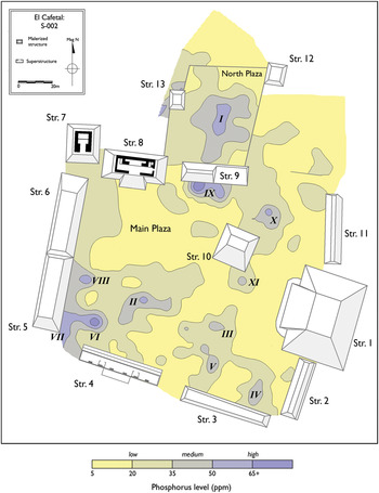
Examination of the concentrations of phosphorus at El Cafetal reveals clear activity patterns (Figure 9). Analyzing the relative phosphorus levels demonstrates that El Cafetal's Main Plaza has high relative phosphorus concentrations towards its center (Figure 9:II and III). This pattern is consistent with the phosphorus mapping results at the non-Maya center of El Coyote located in the Cacaulapa Valley about 80 km east of El Cafetal (Wells Reference Wells2004). Just as at El Cafetal, high phosphorus concentrations at El Coyote were found in the middle of the southern end of the Main Plaza. Ethnographic accounts of Lenca populations by sixteenth-century Spanish historians indicate that feasting was a common display of chiefly largesse and a mechanism for mobilizing labor (Wells Reference Wells2004:80). Elevated soil phosphorus levels are consistent with food preparation and feasting, supporting the notion that central plaza areas may have been used for such public displays.
Phosphorus concentrations at El Cafetal suggest that activities that produced high phosphorus concentrations (including food preparation and refuse disposal) were widely dispersed across the open plazas at the center.

El Cafetal's North Plaza also has a centrally located phosphorus concentration (Figure 9:I). Interestingly, the chronologically later North Plaza was apparently used exclusively for public ceremonial activities. Moreover, Structures 9, 12, and 13 do not appear to be residential in function, and might therefore have served a more ritual purpose. Ceramic data from excavations of the North Plaza suggest that the cobble floor was a later addition to the site, coinciding with the end of the eighth century a.d., a time when Copan and Quirigua were rivals. This addition, facing northward to Quirigua, may result from El Cafetal's ruler's expressing a new prosperity and affiliation with Quirigua that occasioned the relocation of public activities from the Main to the North Plaza.
Except for small concentrations to the south of Structures 9 and 10 (Figure 9:IX, X, and XI), the northern end of the Main Plaza had generally lower phosphorus concentrations. In the southern sector of the site, however, there were five phosphorus accumulations in addition to the two centrally located concentrations (Figure 9:II and III). These other concentrations were located to the north of Structure 3 (Figure 9:IV and V) and Structure 4 (Figure 9:VI), as well as to the east of Structure 5 (Figure 9:VII and VIII). Their proximity to residential structures suggests they are the result of domestic activities (food processing, organic craft production, or human and/or animal waste activities) rather than public ceremony.
Outside of the plazas several areas exhibited elevated phosphorus levels. Two such areas were identified south of Structure 4 (not shown in Figure 9) and are likely linked to the accumulation of refuse from domestic activities associated with Structure 4. It is likely that the residential buildings to the south and west of the site are ringed by such middens. Another area of elevated phosphorus is located to the north and west of Structure 13. Although a midden as well, it is likely that this concentration results from activities associated with the North Plaza.
Overall, the concentrations at El Cafetal appear to indicate the use of the center's open spaces for both ceremonial/public and domestic/private activities. The former were generally located in the centers of the two plazas, while the latter were closely associated with the center's residential structures. The high number of concentrations (n = 11) indicative of activities within these plazas suggests that these open spaces were not cleared of the debris that accumulated as a result of these activities. Perhaps the combination of: (1) the poor drainage of these surfaces, (2) the difficulties of sweeping earthen surfaces, and, (3) cultural predispositions relating to litter and refuse disposal provide physical, pragmatic, and cultural explanations for these patterns.
Open space at El Paraíso
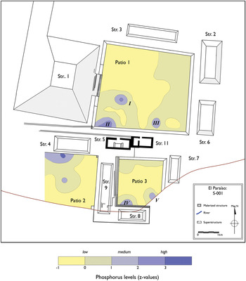
At an initial glance, the phosphorus levels of the El Paraíso patios (Figure 10) clearly suggest that inhabitants used and treated their center's open spaces quite differently from their neighbors living at El Cafetal. An obvious feature of the El Paraíso distribution is the relatively low levels of overall phosphorus throughout both Patios 1 and 3. Patio 1 is the largest patio sampled at El Paraíso and given its association with the center's most important ceremonial building, Structure 1, it most likely functioned as an open public area, making its use analogous to that of the Main Plaza at El Cafetal. As such, this patio would have been the most likely locus for ritual ceremonies, public feasts, and group meetings (see Inomata Reference Inomata2006), even though this space is restricted and somewhat inaccessible from outside. Furthermore, these activities would have potentially included the use, preparation, and disposal of phosphorus-rich organic materials. Patio 1's single largest concentration (Figure 10:I) is located at the intersection of the central axes of Structures 1 and 5—suggesting that this was the location of ritual activities associated with the site's largest ceremonial structure and its most important administrative building.
Phosphorus concentrations at El Paraíso contrast markedly with those at El Cafetal, suggesting that the plaster floors of the El Paraíso sunken courts were swept clean, and that few phosphorus-producing activities were carried out in these spaces.

In the southwestern corner of Patio 1, where phosphorus Concentration II was recorded, excavations revealed a drain that helped clear this patio of water. It seems probable that during El Paraíso's occupation, water would have collected in this corner of the patio, allowing greater absorption of phosphorous and elevating local levels. This area was also the locus of higher concentrations of artifacts relative to the rest of the site. Consequently, it appears that Concentration II likely results from depositional rather than behavioral activities.
Patio 3 was a private space associated with residential buildings (Structures 7, 8, and 9) and together with them may have formed the residential compound of El Paraíso's ruling family. As such, Patio 3 hosted domestic activities, including tool production and food preparation (for an example at Copan, see Hendon [Reference Hendon, MacEachern, Archer and Garvin1989]). The areas of elevated phosphorus (Figure 10:IV and V) are located in the court's southern edge, resulting from activities associated with Structure 8. Interestingly, it is possible that, just as in Patio 1, Patio 3 drained water to its southwestern corner. Consequently, Concentration IV could be seen as analogous to Concentration II—that is, elevated phosphorus levels might reflect the repeated pooling of water and debris rather than the location of particular activities.
El Paraíso's Patio 2 differs significantly from the other patios at the site. It had an earthen rather than plaster floor, and, since neither Structure 4 nor Structure 9 faced onto it, likely served as a “backyard.” Its location, therefore, would render it ideal for refuse deposition and perhaps those domestic activities deemed unsuitable for the central patios. These uses are borne out by the heavy phosphorus accumulations both along the center line and to the south of Structure 4.
Despite their concentrations, these two open spaces appear overwhelmingly clear of phosphorus accumulation relative to El Cafetal. Given their function as ceremonial and residential spaces, it seems unlikely that both these patios were nearly devoid of activity. It is possible that the surfaces at El Paraíso were not occupied long enough to allow for anthropogenic phosphorus to accumulate in substantial and detectable levels. This lack of measurable accumulation could be due to one of several factors: (1) since both Patio 1 and 3 floors were part of their respective patio's final phase of construction, they were in use for no more than 100 years before the center's abandonment, (2) low levels of phosphorus could indicate that only a small group of people made use of these open spaces for their daily or ritual activities, (3) the dearth of phosphorus accumulation may result from a particular combination of behavioral habits and cultural predispositions. If Patios 1 and 3 were swept clean after large events and generally maintained free of refuse, the build-up of phosphorus would have been prevented. Ethnographic studies (for example, Hayden and Cannon Reference Hayden and Cannon1983) have shown that modern Maya populations sweep their courtyards free of debris, partly as a way to maintain purity associated with ritual buildings (Wells et al. Reference Wells, Terry, Parnell, Hardin, Jackson and Houston2000:457).
Summary
Given that it remains difficult to identify the activities that resulted in phosphorus concentrations at either site, only the intensity, frequency, and pattern of these activity areas can be currently evaluated. In fact, according to those criteria, the open spaces at El Cafetal and El Paraíso reflect temporal, demographic, behavioral, and perhaps even cultural variations between their two populations. The most obvious difference relates to the overall intensity of phosphorus levels. It would seem that El Paraíso's lower levels indicate a degree of sweeping and clearing of open spaces not seen at El Cafetal. The greater frequency of concentrations at El Cafetal also suggests that some areas of the Main Plaza were used more intensely (and for longer periods of time) than at El Paraíso. In short, the phosphorus results suggest that the El Paraíso patios were only lightly used by a relative few compared to El Cafetal's open, accessible, and heavily trafficked plazas.
Beyond temporal, demographic, and even behavioral (such as sweeping) explanations for the differences in phosphorus concentration at El Cafetal and El Paraíso, there remains the possibility that cultural predispositions played some influential role. For instance, the differences between the residential southern half of El Cafetal's Main Plaza and El Paraíso's residential Patio 3 reflect different patterns that are not explained as a function of length of use, size of population, or even clearing/cleaning behaviors. The five hotspots located in front of Structures 3, 4, and 5 at El Cafetal (Figure 9: IV–VIII) have no real analog at El Paraíso. This difference might reflect distinct domestic customs that speak to cultural traditions. In short, since the inhabitants of El Cafetal and El Paraíso perceived and used open space differently, it is possible to suggest that their inhabitants were culturally and behaviorally distinct from one another.
Material Culture
The final category compared here is the material culture—primarily pottery—at both centers. Perhaps the least normative in nature of all the lines of evidence due to its greater susceptibility to changing economic, social, and political conditions, the ceramics of these two centers nevertheless exhibit surprising differences that reinforce patterns observed in other lines of evidence, suggesting that the sites' inhabitants may have shared little more than the valley in which they lived.
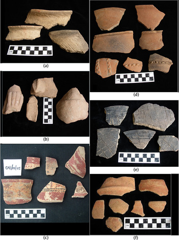
Preliminary analysis by Cassandra R. Bill suggests that the Late Classic period ceramic assemblage from the El Paraíso region is characterized by a number of locally manufactured types as well as a significant amount of pottery likely produced in the Copan region. Additional minor components include vessels imported from other parts of western Honduras as well as possible imports from the site of Quirigua in the Motagua Valley. The initial analysis was based on the examination of 7,500 potsherds, and has been supplemented and expanded by approximately 20,000 additional sherds (Bill Reference Bill, Canuto and Bell2005; Bill et al. Reference Bill, Bell, Canuto and Geller2006).
Late Classic period ceramic household inventories in the El Paraíso Valley indicate that the valley enjoyed a robust local ceramic economy that includes vessels that represent local versions of widely shared regional traditions common throughout the southeast Maya area (Bill et al. Reference Bill, Bell, Canuto and Geller2006). Based on a consistency of distinctive paste characteristics and covarying forms, Bill (Reference Bill, Canuto and Bell2005) has defined several local ware types and varieties that include jars (Cafetal Café, Scopone Brushed, and Masica Incised: Paraíso Variety, all assigned to the Cafetal Group; Morja Micaceous; and other “Jicatuyo” tradition jars), modeled and scored censers (Rosario Incised), and small orange-slipped bowls (Naranjitos Orange-Red) (see Figure 11). These and other Late Classic local types represented in smaller numbers indicate that a full range of vessel types and forms, including fine-ware serving vessels, was produced and available locally.
Household ceramic assemblages at El Paraíso (a–c) and El Cafetal (d–f) are also distinct. (a) Copan utilitarian pottery, Casaca striated: Casaca variety; (b) Copan censerware, Sepultura: Sepultura variety; (c) Copan fineware pottery, Copador; (d) El Paraíso Valley utilitarian pottery, Scopone Brushed: Scopone variety; (e) El Paraíso Valley censerware, Tesoro: variety unspecified; (f) El Paraíso Valley fineware, Los Naranjitos Orange: Los Naranjitos variety.

An additional and significant component of the valley's Late Classic assemblage consists of ceramic types that are rare to nonexistent in other parts of western Honduras, but extremely common in the Copan site core. While it is possible that some of these vessels are locally manufactured versions of Copan types and varieties, Bill has observed that the pastes and forms of the vast majority are identical to those that occur at the site of Copan itself, making it almost certain that they were produced somewhere in the Copan ValleyFootnote 1 (Bill Reference Bill, Canuto and Bell2005; Bill et al. Reference Bill, Bell, Canuto and Geller2006).
There are several clear examples of direct Copan imports. Relatively rare outside of the Copan Valley and western El Salvador, Copador polychromes comprise approximately 50% of the fine-ware sherds found in the El Paraíso Valley; vessels belonging to Copan's polished black/brown Surlo Group (also rare elsewhere in Honduras) constitute an additional 20% of the fine ware assemblage; and Copan utilitarian wares, including Casaca Striated and Raúl Group jars and bowls, account for some 40% of the utilitarian pottery recovered from sites in the region (Bill Reference Bill, Canuto and Bell2005; Bill et al. Reference Bill, Bell, Canuto and Geller2006). In brief, while the Late Classic ceramic assemblage from the El Paraíso region consists of several types of locally manufactured vessels, it also includes a large Copan-based component.
It is important to note, however, that these ceramic links to Copan are not uniformly distributed among valley centers. As is the case for the lines of evidence discussed above, the ceramic assemblages at El Paraíso and El Cafetal differ markedly from one another. For example, while Copan fine wares are present at both sites, vessels belonging to the polished black/brown Surlo Group appear, on average, to be significantly more common at El Paraíso than at El Cafetal. At El Cafetal, however, a much greater component of the Copan-derived fine-ware assemblage consists of vessels belonging to the Copador Polychrome Type. This difference between El Paraíso and El Cafetal suggests differing associations with, and presumably access to, certain classes of fine wares from Copan by the occupants of these two sites. In addition, while fully 90% of the fine wares at the site of El Paraíso consists of vessels from Copan, the fine-ware assemblage at El Cafetal also includes a large percentage (30–40%) of small locally produced orange-slipped polychrome bowls, which constitute only 5% to 10% of the fine wares from El Paraíso (Bill Reference Bill, Canuto and Bell2005; Bill et al. Reference Bill, Bell, Canuto and Geller2006).
A parallel pattern exists for incense burners found at each site. Locally made incense burners, including composite censers with scored lids and urns and lids decorated with elaborately modeled elements, are much more common at El Cafetal (comprising some 75% of the censer material recovered at that site) than at El Paraíso, where roughly 80% of the censers belong to Copan's Sepultura Group.
Equally striking are the differences in the utilitarian assemblages at El Cafetal and El Paraíso. Locally manufactured vessels, including various types of jars, make up almost 90% of the Late Classic utilitarian assemblage at El Cafetal. In contrast, at El Paraíso, these locally produced wares comprise only some 30% of the utilitarian vessels, and Copan types are much more common (Bill Reference Bill, Canuto and Bell2005; Bill et al. Reference Bill, Bell, Canuto and Geller2006).
While these percentages reflect distinctions documented to date, it should be noted that very little pottery has been recovered from the site of El Paraíso (n = 8,231). This contrasts sharply with much denser pottery deposition patterns at El Cafetal (n = 57,528) and its associated groups, including Site 07, Los Naranjitos (n = 25,663), located to the west of the El Cafetal Main Group (Hostenske Reference Hostenske2006). While these distinctions combine with the phosphate analysis of patio soils to suggest that residents at each site engaged in very different activity and refuse disposal practices, they also result in very different assemblage sizes, which must be acknowledged in the comparison.
Summary
The portable material culture associated with the sites indicates that the residents of each enjoyed a different relationship with paramounts at Copan. The assemblage at El Cafetal, while including some censers and fine wares imported from Copan, is predominantly composed of local pottery. At El Cafetal, only 10% of the utilitarian pottery, 25% of the censers, and 60–70% of the fine wares analyzed to date appear to have come from Copan. This means that a significant percentage (30–40%) of the fine wares, consisting of orange-slipped polychrome bowls, appears to have been made locally.
In marked contrast, the ceramics at El Paraíso strongly suggest that residents participated extensively in the Copan ceramic economy. While a local ceramic tradition is present in the El Paraíso assemblage, this tradition is dwarfed by the high relative frequencies of ceramics imported from Copan. Up to 95% of the fine wares, 80% of the censers, and 70% of the utilitarian wares found at El Paraíso (analyzed to date) appear to have been manufactured in and imported from the Copan Valley. Copan types commonly found at El Paraíso include Sepulturas group censers, Casaca Striated and Raúl Group utilitarian jars, and Copador and Surlo fine wares. Few locally manufactured fine wares (orange-slipped polychrome bowls) or fine wares from central Honduras (Ulua Polychrome, Chamelecon Polychrome) or the Motagua Valley (Tipón Group types) have been found at El Paraíso to date. These extremely high frequencies suggest that El Paraíso residents may have been full participants in the entire domestic economy of the Copan Valley during the Late Classic period.
The ceramic assemblage, as currently understood, therefore, underscores differences in affiliation among the residents at El Paraíso and El Cafetal, suggesting that each participated in distinct economic spheres, despite their close proximity.
Mortuary Patterns
No human interments that can be securely dated to the Classic period have been recovered to date in the El Paraíso Valley. This dearth of human skeletal remains is likely due to a combination of factors. The high acidity levels of local soils that make postdepositional contexts hostile to the preservation of organic material is one of the most likely contributing factors. Soils across much of the valley are classified as Typic Argiustoll with slightly acidic to neutral pH. As is the case for soils throughout much of Mesoamerica, this acidity combines with abundant moisture and high temperatures to make such soils notoriously hostile to the preservation of skeletal remains. Relatively low numbers of animal bones have been recovered in the valley (n = 1,069; approximately 1.14 bones/m3 excavated), suggesting that the lack of human skeletal remains is consistent with general preservation patterns.
The excavation strategies employed may also have limited the likelihood of encountering human remains. In accordance with regulations administered by the Instituto Hondureño de Antropología e Historia (IHAH), PAREP excavation strategies emphasized limited exposure of final-phase architecture rather than vertical excavations into the fill of well-preserved earthen and cobble substructures that regional patterns suggest were the likely locations of Classic period interments. This emphasis may have significantly reduced the likelihood of uncovering burials. It should be noted, however, that in cases where the final-phase architecture was not preserved, excavations did penetrate substructure fill, and no interments were found in these excavations.
Given the differences observed in other lines of evidence, it is also possible (if relatively unlikely) that a burial pattern that differed significantly from Maya and central Honduran patterns may have been employed in the El Paraíso Valley, with interments having been placed in off-mound cemeteries or other locations yet to be identified. Furthermore, given its likely role as an administrative outpost, it is possible that interments at El Paraíso were removed and returned to the Copan Valley when the site was abandoned at the end of the Classic period. This would, of course, not explain the lack of interments discovered to date at El Cafetal and its surrounding settlement.
While no interments that can be securely dated to the Classic period have been recovered, two fragmentary and incomplete concentrations of human bone have been analyzed as part of PAREP investigations. One concentration was found in wall-fall and associated with other debris (including modern trash) 1.5 m above the interior floor of El Paraíso Structure 5, a small elite residence located between Patios 1 and 2 at El Paraíso (Figures 4b and 7a). As the remains were scattered throughout the wall-fall debris and modern trash that filled the room, the context suggests that they had been extensively disturbed and redeposited, making it impossible to date them securely. A second collection of skeletal material turned over to PAREP staff by a local resident was reported to have been excavated from within a concentration of river cobble (likely the remains of a small residential structure) directly northwest of El Paraíso Patio 4 during the course of modern construction activities in the town of El Paraíso. The area had been sealed by a cement floor and the foundation of a small house by the time the find was reported. A chert biface reportedly found in association with the remains suggests their antiquity, but no further temporal assessment is possible.
PAREP osteoarchaeologist Pamela L. Geller conducted a preliminary analysis of both of these small, fragmentary collections. The redeposited concentration of remains mixed with modern refuse in El Paraíso Structure 5 included the partial skeletons of two individuals. Individual 1 appears to have been an adult male, 30–50 years of age at death, with extreme dental wear, while Individual 2 appears to have been a subadult, 5–7 years of age at death. Both individuals were represented by elements of the entire skeleton in extremely fragmentary condition. The individual turned over to PAREP investigators by a local resident was represented by approximately 25% of the skeleton and appears to have been a subadult, 5–9 years of age at death. As these interments cannot be dated securely to the Classic period, they have not been included in the lines of evidence used to explore Classic period patterns in the El Paraíso Valley.
Summary
As no human remains that can be dated securely to the Classic period have been found to date in the El Paraíso Valley, we can make no assertions about the similarities or differences in mortuary patterns at El Cafetal and El Paraíso. It is also not possible to take advantage powerful analytic techniques (including stable isotope ratio analysis, nonmetric trait analysis, and DNA assays) employed in the analysis of human remains to address questions of ethnicity, biodistance, and residential histories.
DISCUSSION
As the evidence presented above indicates, the El Paraíso Valley contains two linked but culturally distinct contemporaneous Late Classic period centers. Differences in spatial plans, architectural styles and embellishment, use of open space, and portable material culture suggest that El Cafetal was a long-lived, autochthonous center, while El Paraíso was established by Copan elites in the mid-seventh century a.d. as an administrative outpost. Located near the then-abandoned earlier regional capital of El Guayabal (Cagnato Reference Cagnato2008; Sharer et al. Reference Sharer, Canuto, Bell, Kaplan and Love2011), the siting of El Cafetal continues settlement patterns established in the Middle and Late Preclassic periods. El Paraíso, in contrast, appears to have been established ex nihilo in the foothills above El Cafetal at some point in the early to mid-seventh century a.d. Its enclosed sunken patios, plaster surfaces, cut-stone masonry, and sculpted façades suggest that, from the outset, it was constructed to resemble elite residential complexes at Classic period Copan. Furthermore, its position overlooking not only the majority of the valley, including El Cafetal, but also all major exit and entry points suggests that its location was deliberately and strategically chosen to monitor and dominate the region.
Despite marked differences in architectural style and spatial organization between the centers, residents of both carried out the same basic daily activities (tool production, residence, food preparation, and ritual behavior), although these activities were conducted in different areas of each settlement. Both El Cafetal and El Paraíso also include a full range of residences (elite to commoner) suggesting extensive hierarchical differences at each. In other words, economic and status distinctions alone do not distinguish the inhabitants of these two centers from one another.
Yet these two sites—and by association, their inhabitants—were extremely dissimilar, differing in their: (1) access to Copan elite goods, (2) strategies for the acquisition of utilitarian goods, (3) use of open space, (4) architectural traditions, (5) living space preferences, and (6) stylistic aesthetics. Given that facile functional and status distinctions alone cannot explain differences in patterning at these centers, a plausible alternate hypothesis is that their inhabitants asserted significantly different identities and affiliations, which may have included social, political, economic, linguistic, and ethnic distinctions. It seems reasonable, therefore, to suggest that El Cafetal and El Paraíso were inhabited by two distinct social groups living side-by-side in the valley during the contentious and dynamic Late Classic period. We further suggest that one of these groups, resident at El Paraíso, figured prominently in administrative strategies marshaled by Copan paramounts to exert influence in, consolidate, and effectively govern the hinterlands of the Copan kingdom.
This administrative strategy, which highlighted rather than masked cultural distinctions, is thus far unique among Maya polities. While burgeoning research in the Maya area is documenting an increasingly diverse array of administrative strategies (Golden et al. Reference Golden, Scherer, Muñoz and Vásquez2008; Houston Reference Houston1993; Inomata Reference Inomata2006; Lucero Reference Lucero1999; Marcus Reference Marcus2003; Martin and Grube Reference Martin and Grube2008; Sharer and Golden Reference Sharer, Golden, Golden and Borgstede2004; Stuart and Stuart Reference Stuart and Stuart2008), the outpost strategy presented here appears to have been limited to the Copan kingdom. This regional specificity may be due, in part, to the challenges faced by Copan rulers as they attempted to administer a kingdom on the southeastern edge of the Maya world. Considered in the context of the broader culture-history of the southeast Maya area, the observed differences between El Paraíso and El Cafetal are consistent with the proto-Ch'orti/proto-Lenca distinction that appears to have characterized the entire region in this period (Metz et al. Reference Metz, McNeil and Hull2009). The heterogeneity of this dynamic frontier zone likely presented Copan rulers with challenges not encountered by their counterparts in the Maya Lowlands, and Copan paramounts appear to have met these challenges in unique ways.
Paired Centers in the Copan Kingdom
While this administrative strategy has not been documented in other Maya polities, the patterns that appear to be its material correlates are replicated multiple times elsewhere in the Copan region. There are several examples outside the El Paraíso Valley of two contemporaneous, equivalently-sized, proximate—yet markedly different—secondary centers in a geographically circumscribed area (see Figure 5). The three best documented examples are: (1) the Río Amarillo Valley (ca. 9 km2) where the eponymous Río Amarillo site is paired with the little-known Piedras Negras site less than 3 km to the north, (2) the La Florida Valley (ca. 75 km2) where the Late Classic site of El Abra is located 2 km southwest of the contemporaneous site of El Puente, and (3) the La Venta Valley (ca. 65 km2) in which the sites of Los Higos and Roncador may form a similar pair. Additionally, Wendy Ashmore (Reference Ashmore2007:146) has suggested that the Morja site on the southwestern edge of the vast (2,000 km2) Motagua River valley may have been paired in the same way with Quirigua during the early occupation of each.
Although these other site pairs have not as yet been studied with the same intensity as El Cafetal and El Paraíso, preliminary parallels can be drawn from the data currently available. Firstly, it is clear that all of these centers flourished in the Late Classic period. Given the lack of comparable data, however, it is not currently possible to determine the precise temporal relationship between the centers in each pair. Secondly, each of these pairs is located at a critical node along routes connecting Copan with the Peten to the north and central Honduras to the east. Thirdly, the paired sites are architecturally and spatially distinct from each other in ways reminiscent of the differentiation between El Cafetal and El Paraíso. This distinction is especially clear in the case of El Puente and El Abra (Figure 12).
Additional paired sites in the Copan region suggest that the administrative strategies documented in the El Paraíso Valley are likely not unique and that Copan elites may have deployed the paired-center strategy widely within the region (after Nakamura et al. Reference Nakamura, Aoyama and Uratsuji1991; Saturno Reference Saturno2000; Vlcek and Fash Reference Vlcek, Fash, Urban and Schortman1986).

Based on these data, it would appear that the paired centers in the El Paraíso Valley are but a single instance of a wider regional pattern found throughout Copan's Classic period kingdom. If, in fact, the paired centers in the El Paraíso Valley do reflect the existence of different social groups cohabiting within the valley, it is possible to suggest that this paired center pattern reflects an administrative strategy tailored to the complex multiethnic landscape of the entire Copan region. Furthermore, if the patterns suggested by the El Paraíso Valley chronometric data hold true for the rest of the Copan region, it would then be possible to hypothesize that, in the case of each pairing, the earlier of the two centers would be the one inhabited by the local autochthonous population, while the later settlement was likely established under the auspices of, and possibly even populated by, Copan's ruling elite. These hypotheses, of course, await further testing.
As a regional distribution pattern, the pairing of secondary centers throughout the Copan region cannot be fully explained by cost-minimizing, central-placement models (contra Inomata and Aoyama Reference Inomata and Aoyama1996). We suggest, instead, that this pairing pattern is best described as a strategy of duplication, wherein a “rationally” distributed set of rural centers inhabited by local people was paired with a second functionally redundant center consisting primarily of Copan-based and/or affiliated families. As a pattern of settlement, this duplication seems to be a subtle but purposeful strategy designed to control an already inhabited landscape. New centers bearing a Copan imprimatur in style, organization, and decoration encroached on long-settled but strategic areas without displacing their pre-existing populations.
CONCLUSION
The data and interpretations provided here posit a political model of and for both Late Classic period settlement in the El Paraíso Valley and regional patterns among other secondary centers in the Copan kingdom. In fact, our explanations are consistent with all the evidence for the uniquely complex composition of the Copan region's population. Although all the mechanisms leading to the dominance of Copan's Lowland Maya dynasty remain unclear, it would seem plausible now to suggest that a major Copan strategy for controlling an inhabited region has been revealed. Furthermore, this precise and consistently applied strategy, thus far unique in the Maya area, was not only initially successful but also indicative of the Copan rulers' centralizing and expansionist agenda.
The turmoil that erupts in the mid-eighth century a.d. does much to blur and obfuscate this original paired center pattern. Copan's war with Quirigua, and the resulting death of Copan's thirteenth ruler, threw the region and its secondary centers into chaos. Even in the El Paraíso Valley, the postconflict construction sequence of El Cafetal shows the adoption of new architectural and decorative canons. It is possible that the “paired center” strategy failed—or at least shifted—with the diminishment of Copan's supremacy.
While the data presented here cannot fully resolve the larger debate concerning the nature of Classic period Maya polities, it would seem that they do indeed lend some credence to the idea that Classic Maya rulers initiated strategies of political integration that, though perhaps doomed to fail, aimed at regional and territorial centralization. It is also clear that these strategies were precisely calibrated to the local sociocultural landscape and that, in the case of Copan, these strategies included some form of identity politics.
RESUMEN
Investigaciones recientes del asentamiento clásico (400–900 d.C.) dentro del valle El Paraíso, departamento de Copan, Honduras, han identificado un patrón de centros pares que sugieren un nuevo modelo de organización política en la zona sudeste maya. El modelo abarca estrategias administrativas desconocidas en otras partes del área maya que parece haberse basado en establecer centros administrativos para salvaguardar y respaldar los intereses de los gobernantes copanecos en las zonas con mucha diversidad étnica que forman el margen del reinado de Copan.
Publicado por primera vez por el geógrafo alemán, Karl Sapper, en 1897, el asentamiento en El Paraíso ha sido el enfoque de investigaciones esporádicas desde esa época, con Sylvanus G. Morley refiriéndose a fotografías de la escultura mosaico estilo Copaneca tomadas por Samuel K. Lothrop en los 1910s para asociar El Paraíso con Copan. Jens Yde visitó el sitio en su recorrido regional y publicó una descripción más detallada en 1938 y William L. Fash y miembros del Proyecto Arqueológico Copan, Fase 1 (PAC I) publicaron la primera informe del centro El Cafetal en 1979. El Proyecto Regional El Paraíso (PAREP) inició investigaciones en la región en el 2000.
Los dos centros grandes y contemporáneos que dominaban el valle en el período clásico, El Cafetal y El Paraíso, se ubican al menos de 1.5 km de distancia entre los dos y se exhiben diferencias notables en la organización espacial, las técnicas de construcción, el embellecimiento arquitectónico, el uso de espacio abierto y la cultura material portátil. Análisis radiocarbono indica que El Cafetal era un centro de larga ocupación, mientras que El Paraíso se estableció a mediados del siglo VII d.C. Análisis de patrones espaciales confirma que El Cafetal se construyo al estilo de centros no-mayas en la región central de Honduras, con arquitectura de piedra de río, plazas con superficies informales, organización arquitectónica no-ortogonal, y superestructuras y techos perecederos, mientras que El Paraíso se conforma a las tradiciones canónicas mayas clásicas, inclusive las de mampostería de bloques cuadrados de toba, el uso extenso de estuco, la presencia de superestructuras de mampostería y la decoración de fachadas con escultura arquitectónica mosaico tridimensional. El Cafetal se encuentra en los llanos del valle, mientras que El Paraíso está ubicado en la falda de las montañas, apoderándose de una vista amplia del valle y sus rutas de ingreso y egreso. Análisis química (PO4) de los suelos en los espacios abiertos dentro de cada sitio indica que estas áreas se utilizaban de una forma muy distinta en cada sitio, con las plazas de El Cafetal abarcando actividades que producían niveles de fosfato muy altos, y con los patios hundidos en El Paraíso dejados limpios. La cultura material portátil de cada centro apoya y extiende las diferencias entre los dos, con casi 70% de la cerámica utilitaria, 90% de la cerámica fina, y 80% de los incensarios importados desde Copan, mientras que se ve lo inverso en El Cafetal. Estas diferencias sugieren que El Cafetal era centro autóctono mientras que El Paraíso se estableció bajo los auspicios de Copan, probablemente sirviendo como un centro administrativo para salvaguardar los intereses de los elites copanecos en las rutas de intercambio que pasan por el valle.
ACKNOWLEDGMENTS
This research was supported by the Heinz Foundation, Dumbarton Oaks, FAMSI, Yale University's Albers Fund and MacMillan Center for International and Area Studies, the Kenyon College Faculty Development and Teaching Initiatives programs, the Kenyon Honduras Program, Tulane University's Middle American Research Institute (MARI), the California State University (CSU), Stanislaus RSCA Grant Program, the CSU Stanislaus Student Research Council, and the National Endowment for the Humanities Summer Stipend Program. Investigations were conducted under the auspices of the Instituto Hondureño de Antropología e Historia, and we thank its directors—Ricardo Agurcia Fasquelle, Dario Euraque, and Virgilio Paredes—and the many dedicated and talented IHAH staff members with whom we've had the pleasure to work at the national, regional, and local levels. We are indebted to many colleagues for their support and advice over the years, especially William L. Fash, Robert J. Sharer, Patricia A. Urban, and Edward M. Schortman, whose work at Copan and within southeastern Mesoamerica laid the foundation for these investigations and whose valuable comments continue to inform it. We thank our collaborators and student colleagues, whose work produced much of the data presented here, and extensive gratitude is owed to Jorge Ramos, Jennifer von Schwerin, Pamela L. Geller, and William L. McFarlane for their collaboration and contributions to the research presented here. We are especially grateful to Cassandra R. Bill for her meticulous, insightful, and nuanced analysis of the El Paraíso Valley ceramic assemblage. We would also like to thank Richard E.W. Adams, Francisco Estrada-Belli, Joyce Marcus, and Jeff Seibert for their insightful review comments, which greatly improved the final version of this article. All shortcoming of this paper, however, remain entirely our own.