

How do small-scale residential sites contribute to the emergence of social complexity? This paper explores this question using data from the excavations at Gramalote on the North Coast of Peru during the second millennium BC. Furthermore, it explores how these small settlements could have been integrated into a regional economy through social encounters and exchanges of subsistence products essential for daily life, functioning as an extended community.
Studies of social dynamism and interaction among ancient small-scale settlements are scarce. Most archaeological attention has been devoted to the study of urban and/or monumental centers with obvious religious and/or civic functions (Trigger Reference Trigger1990). This is because large centers (e.g., cities, religious monumental centers) are thought to represent the most efficient managerial nodes in complex systems (Trigger Reference Trigger1990). Thus, the small-scale settlement is viewed as the antithesis of the urban center: the lowest, least diverse, most homogeneous element within a larger settlement system. In the last decades, this model has been challenged as an oversimplified perspective for small-scale communities in early complex societies (Canuto and Yaeger Reference Canuto and Yaeger2000; Hayden Reference Hayden, Schwartz and Falconer1994; Robin Reference Robin2012).
Indeed, there is an increasing worldwide interest in studying the dynamic role of small domestic sites in structuring social relations (Brumfiel Reference Brumfiel1992; Canuto and Yaeger Reference Canuto and Yaeger2000; Lau Reference Lau2010; Robin Reference Robin2012; Sheets Reference Sheets2002; Stein Reference Stein2002; Yaeger and Robin Reference Yaeger, Robin, Lohse and Valdez2004). In the case of the Andes, studies of early small-scale residential settlements are scarce (Burger Reference Burger1984; Chu Reference Chu2008; Matsumoto et al. Reference Matsumoto, Cavero and Gutierrez2013; Nesbitt Reference Nesbitt2012), although there is increasing interest in these types of studies for later periods (Bawden Reference Bawden1982; Cutright Reference Cutright, Cutright, Lopez-Hurtado and Martin2010; Vaughn Reference Vaughn2009). Thus, it is difficult to assess the role played by small-scale residential settlements during the early periods of Andean prehistory. This article attempts to address this gap, contributing a bottom-up perspective to study the social dynamics and economic interactions of early small-scale residential settlements in the Central Andean Region.
If we accept that small-scale residential settlements are part of an extended network of contemporary sites that share the same interests and that may have partially relied on the resources provided by their peers to subsist, it is reasonable to propose that settlements such as Gramalote were not isolated but part of an active social and economic network of sites during the second millennium BC.
A community can be defined as a dynamic, socially constituted institution that is contingent upon human agency for its creation and continued existence (Yaeger and Canuto Reference Yaeger, Canuto, Canuto and Yaeger2000:5), or as a group identification resulting from formation processes that promote group affiliation. A community can be a singular social institution that generates and is generated by suprahousehold interactions. In this perspective, excavations should be done at multiple sites to get a better sense of how a community functions as a whole. Because this will comprise a life-long project for a single archaeologist, an alternative approach is undertaken, in which a single site is studied on a large scale (e.g., extended areas, testing multiple sectors of the site) for a detailed understanding of a discrete part of a community. Therefore, if the community is understood as an environment that actively links people, materials, and ideology, then it becomes a dynamic, heterogeneous, and social entity that provides a unique “bottom-up” perspective for evaluating ideas about interaction in early complex societies (Lau Reference Lau2010).
Methodologically, extensive excavation of basic analytical units such as houses is important because it provides information about interactions between and also within households in a single site. Understanding the external social and economic interactions made by these households with other settlements of an extended community in a given region may help to understand both the nature of those interactions and the resulting food and product exchange. One major goal of the investigations at Gramalote was to define the household component of an Initial Period (1500–1200 BC) fishing settlement and understand how these households interacted in a larger territory. This provides many potential questions to address: How was the household organized? What was the daily praxis of these households at Gramalote? What kinds of activities did individuals perform besides fishing? Did different households have access to similar food and products? Is there any evidence of social status within the households at Gramalote? How were households integrated in this site? More specifically, were house structures similar? How big or small were they? How were the houses distributed? What kinds of activities did they perform in the houses? In a broader perspective, how can these questions detail a broader understanding of social and economic organization during the second millennium BC in the Central Andean Region?
In describing and interpreting the Gramalote site within this theoretical framework, ethnographic data from the neighboring fishing community of Huanchaco will additionally be presented as a contemporary, analogous example of a local model of social dynamics. Ethnographic data, when understood with appropriate limitations, could help to build local models that empower archaeological data sets. Within the North Coast of Peru, few to none of the existing local ethnographic studies have been discussed or included in the archaeology of coastal communities, although there is great potential for future analysis (Sandweiss Reference Sandweiss1992). In this article, local ethnographies enrich the archaeological interpretation and discussion presented.
The Gramalote Site
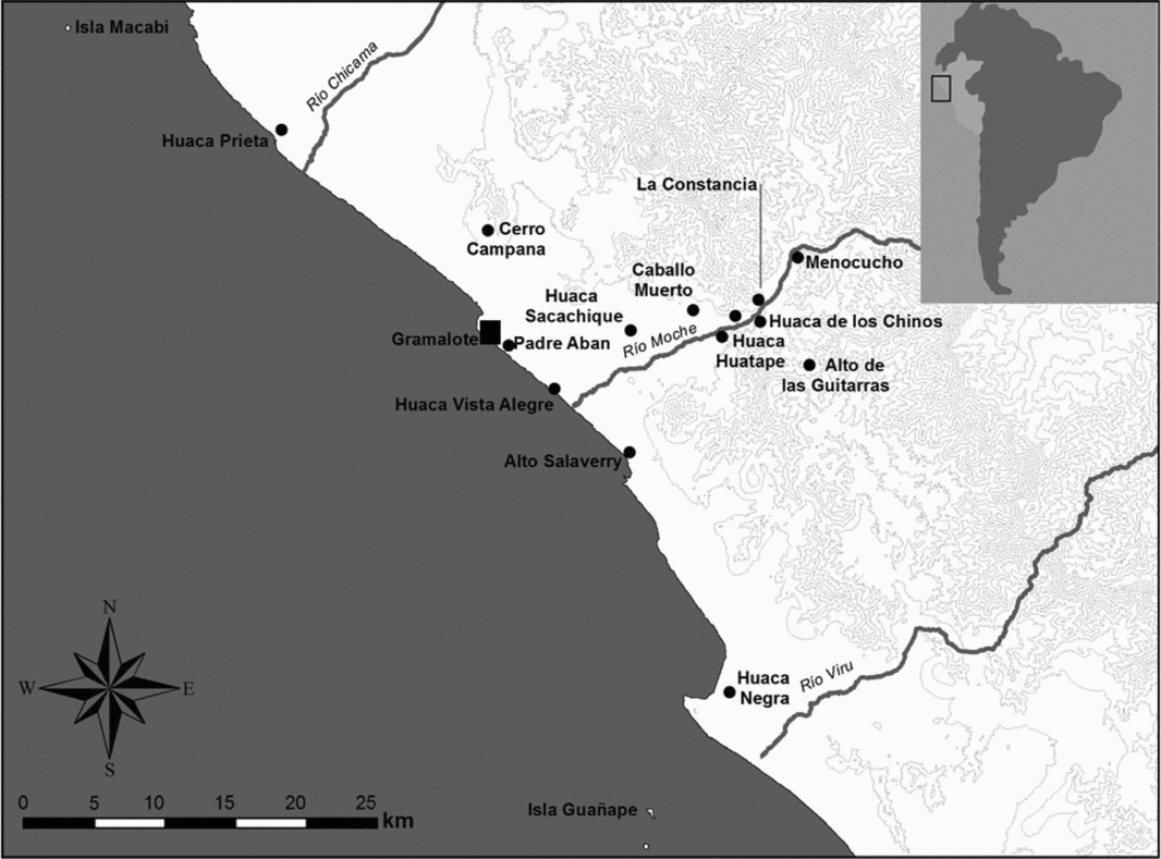
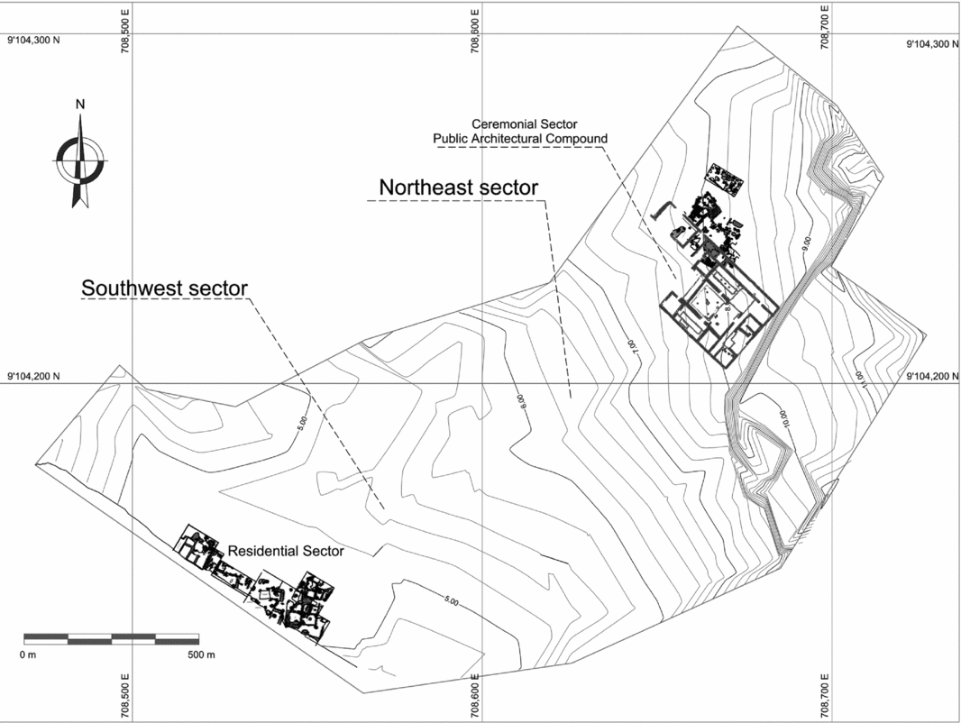
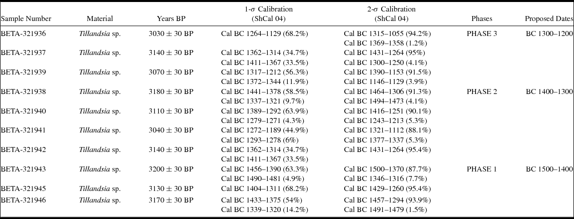
Gramalote is located on the coast of the Moche Valley, 2 km south of the traditional fishing village of Huanchaco (Figure 1). The site lies on top of a 13-m-high marine terrace overlooking the beach. Although the estimated size of the site during its use is approximately 3.5 ha, only a third of this space was covered with habitation areas and a ceremonial facility (Figure 2). The site was continuously occupied for 300 years (Table 1). During Phase 2 (1400–1300 cal BC), which represents the height of the occupation of the site, the southwest sector was a domestic area, and the northeast sector was a ceremonial sector with a large public architectural compound. This compound had an annex on its northeast side, and a few scattered domestic units are located northeast of this building.
Geographic location of the Gramalote site. Note other earlier and contemporary settlements in the Moche and neighboring valleys.

Map of the Gramalote archaeological site. Note the location of the residential sector and the ceremonial facility located on the northeast end of the site.

Absolute Dates from Gramalote and Proposed Occupational Phases. Oxcal v4.2.4 Bronk Ramsey (Reference Bronk Ramsey, Scott and van der Plicht2013); r:5 SHCal04 atmospheric curve (McCormac et al. Reference McCormac, Hogg, Blackwell, Buck, Higham and Reimer2004)

Gramalote was discovered during the surveys of the Chan Chan Moche Valley Project in 1973. It was later excavated by Shelia Pozorski, who placed test pits around the site. Pozorski used the data gathered from the test pits to study the dietary component of the Initial Period (BC 1500–1200) in the Moche Valley (Pozorski Reference Pozorski1976) and compared it with the subsistence data from the contemporaneous inland ceremonial center of Caballo Muerto Complex, proposing that Gramalote had been a domestic fishing settlement with an effective, systematic seafood procurement system, while Caballo Muerto had an efficient and productive agricultural irrigation system (Pozorski Reference Pozorski1976; Pozorski and Pozorski Reference Pozorski and Pozorski1979). Together, Gramalote and Caballo Muerto were seen as two parts of an integrated economic unit. Shelia and Thomas Pozorski argued that “the specific orientation of this procurement system plus the narrow range of non-subsistence site activities at Gramalote, suggested that the site might have been a subsidiary or even a colony established to insure a continuous supply of marine products for the inland complex” (Pozorski and Pozorski Reference Pozorski and Pozorski1979:430). An alternative interpretation is presented at the end of this article.
In 1987, Petronila Velasquez from the National University of Trujillo conducted excavations on the east side of the site, successfully identifying areas of activity related to processing seafood (Velasquez Reference Velasquez1987). In 2005, Jesus Briceño and Brian Billman opened two small units in the southwest sector of Gramalote; their report documented two human burials and recorded ceramic fragments, which constituted the first publication of illustrations of pottery from Gramalote (Briceño and Billman Reference Briceño and Billman2008). Between 2010 and 2014, the Gramalote Archaeological Project excavated 18 large units along the southwest and northeast sectors of the site. The results of these investigations are extensively described and analyzed in the doctoral dissertation of Prieto (Reference Prieto2015).
The Spatial Organization of Gramalote
Although the site occupies 3.5 ha, current evidence suggests that it was not all covered by architecture. Additionally, there seems to be an empty area between the residential sector (located on the southwest side of the site) and the northeast, where a large ceremonial facility is located. This facility is surrounded by smaller areas related to the ceremonial activities performed inside the building (Figure 2). In this article, I describe in detail the residential sector of Gramalote and three fully-excavated houses; the description and interpretation of the other houses and the ceremonial facility of the site have been presented elsewhere (Prieto Reference Prieto2015; Prieto Reference Prieto2018). The main residential sector of Gramalote seems to have been organized around a central plaza flanked by long corridors, separating the houses from the public spaces. Houses are not separated by corridors but rather by empty areas used for processing food, as suggested by the presence of hearths and the concentration of food leftovers.
The Southwest Sector: The Residential Area of Gramalote
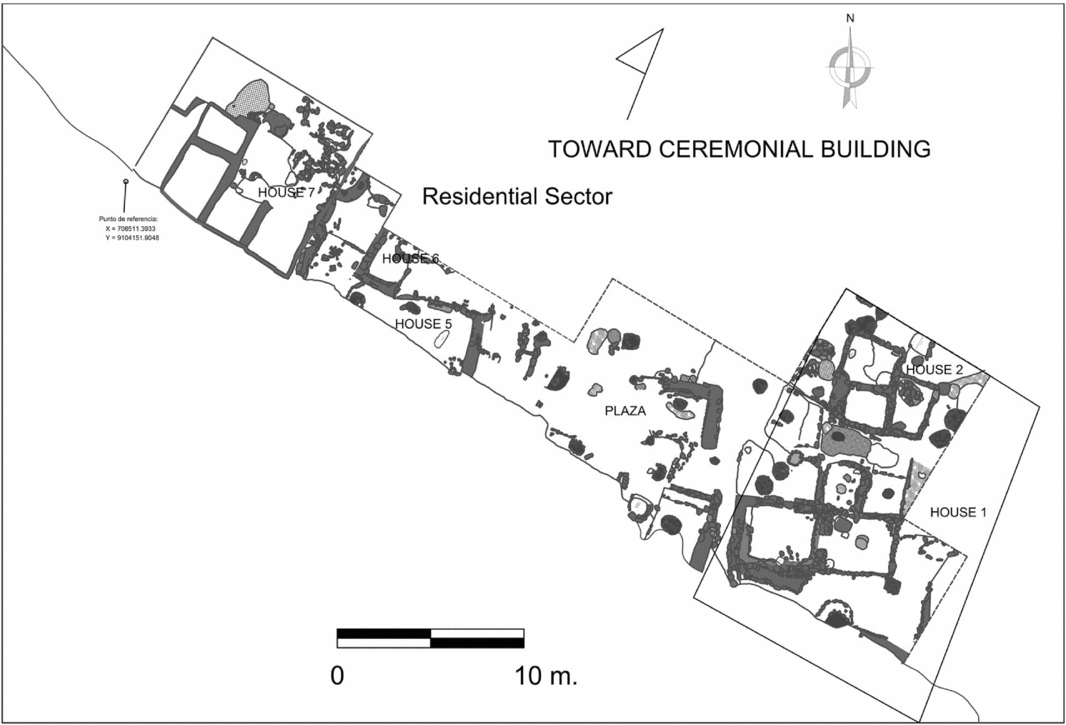
The approximate area of the domestic southwest sector is 5,760 m2 or roughly just over 1/2 ha (Figures 2 and 3). In general, the southwest sector is a residential area where most of the population of Gramalote lived. The study of nine domestic units (five fully excavated and four partially opened) and a considerable side of a plaza with corridors and shared areas between the houses, provides a glimpse into the spatial organization of the residential sector of Gramalote.
Map of the excavated houses and public plaza in the residential sector of Gramalote.

The Central Plaza
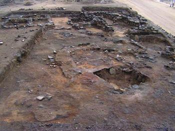
The heart of the residential sector was an open plaza that served to organize the spatial distribution of the dwellings at Gramalote. This centrally located plaza faces the ocean and was built on the edge of the bluff, surrounded by narrow corridors that separated the domestic units where the fishermen and their families lived (Figure 4). The plaza is rectangular in shape, with its widest side on the east-west axis. Current estimations suggest that the plaza is approximately 350 m2, although only 132 m2 have been excavated. The open layout and orientation to the west provided a view of the sea, and the space itself was used for food preparation and ceremonial activities, all of which fostered social interactions within the settlement. The western side of the plaza may have been used to process and cook large quantities of marine products, as suggested by the large amounts of shellfish and fish scales found on the floor, next to several circular hearths and stone grills.
General view (northwest-southeast) of the residential sector. Note on the background of the photo House 1 (right) and House 2 (left). The empty space is the public plaza.

In addition to food processing and consumption, rituals seem to have been an important activity in this public space. The presence of red-painted cobblestones and fragments of anthracite mirrors suggest that ritual ceremonies were performed in the plaza. The red paint may have been applied on the body using ceramic seal stamps, one of which was found in a ritual cache located in the plaza and depicts an anthropomorphic being with piscine and avian attributes.
Two low, rectangular platforms located on the southwest side of the plaza are intentionally built close to the edge of the cliff. They were possibly used to overlook the ocean or to perform displays and rituals. The ritual function of this space is further supported by the interment of an adult male (T-223) with many significant grave goods. His remains show evidence of severe trauma to his left femur, suggesting he would have had difficulty walking during life. This is the only adult male buried in this plaza during Phase 2. The body was buried with a pair of pendants depicting stylized fish, a whale bone snuff tray with a bone spatula, and a plant fiber bag with choloque (Sapindus saponaria) berries, a local plant with insecticide properties. Also present are the remains of an infant with no evidence of previous trauma or a traumatic death. The artifacts found in the adult male burial suggest he may have been a shaman. Furthermore, he is one of the few males at Gramalote who does not have the external osteomas or exostoses in the external auditory meatus, suggesting he did not spend a significant time in the cold ocean as the other adult males did (Kroon et al. Reference Kroon, Louise Lawson, Derkay, Hoffmann and McCook2002). The fact that this adult male was buried in the plaza suggests the Gramalote settlers recognized the public role of the shaman as a local spiritual leader in their settlement.
The plaza appears to have been used for limited storage as well. Two small rectangular deposits were found in the plaza. The first one was 1 m2 in area and approximately 50 cm in depth. Later, this storage facility was transformed into a grave where a child about 3 to 5 years of age was buried (T-217). Interestingly, in the fill of the interior of the storage facility, a wooden paddle, two fragments of anthracite mirrors, two drilled clamshells, a red-painted cobblestone, a small batan with red pigment, and eight pieces of cotton string were found. All these artifacts had to do with the production of red pigment and ritual activity that could have been performed in the plaza. Another group of materials, such as dried seaweed, seabird and unidentified sea mammal bones, and shark vertebrae were recovered inside the structure. Perhaps the food remains are actually those that were originally stored in this facility before it was repurposed as a grave. The second storage facility was a circular, above-ground structure completely sealed by a roof made of coral blocks (locally known as kisos) and mud mortar. Inside the structure, we found a scallop shell and yellow clam shell next to a fragment of a beautiful anthracite plate. At the center of the deposit floor, a red-painted cobblestone was found, and very close to that, a carved, flat piece of a cetacean bone. All these artifacts further reinforce the ceremonial role of the plaza and that despite the obvious role of the deposits, the act of storing was part of the Gramalote ritual process.
The east edge of the plaza was delineated by a long corridor oriented south to north. This public corridor was approximately 1 to 1.5 m wide, with small stones on each side, indicating the intentional division between the public and domestic realm. The plaza and this corridor suggest that Gramalote's residential sector was carefully planned and designed by the builders to establish physical boundaries between the houses and the public plaza.
The Houses at Gramalote
Nine houses were excavated at Gramalote. Due to spatial limitations, I will detail three fully excavated houses, providing a comprehensive understanding of how the inhabitants of Gramalote lived during the Initial Period, and how they were part of a regional network during the second millennium BC in this valley of the Peruvian North Coast. In general, all the houses were constructed with beach stones and kisos, with mud mortar for the walls. All the houses described in this section have small rooms for resting areas and large open spaces (usually enclosed by a low wall) for food preparation and consumption as well as for other domestic activities. The average size of a Gramalote house, including the patio area, was between 80 to 150 m2 with a median of 100 m2.
House 1
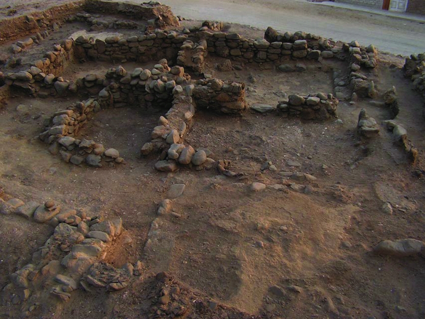
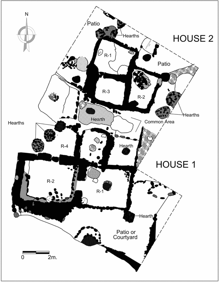
The total surface is 88 m2, and it is oriented toward the north. To date, this is the most well-preserved domestic structure excavated at Gramalote (Figure 5) and has four rooms and an L-shaped open space or patio along its southern and eastern sides (Figure 6).
General view of House 1, Gramalote.

Map of House 1 and House 2.

Within the house is an open rectangular space (R-4) that served as a kitchen, with two circular stone hearths and a circular pit filled with clean beach sand, that was possibly used to store dried and/or salted marine products. Next to the kitchen is a small rectangular room (R-3) with low walls, that was used as a storage facility. At least 70 seabird bones were recovered directly on the floor of Room 3. Most of the bones were vertebrae, furcular, sternum, coracoid, and a few humeri, which are components of the chest of the bird—that yields the most meat. Possibly, the users of Room 3 stored dried/salted seabirds for later consumption.
Room 2 had a total surface of almost 7 m2. The main feature of this room is a U-shaped bench facing the main entrance on the north wall. This bench, and its proximity to the kitchen (R-4), suggests that this room was a food consumption space for the inhabitants of House 1.
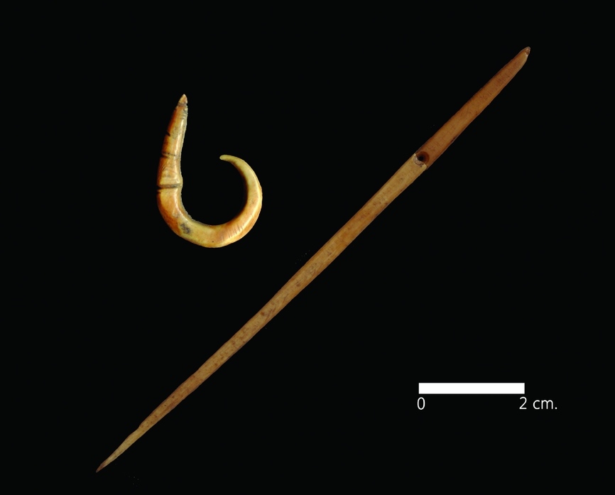
Room 1 has a rectangular shape and a surface area of 9 m2. It is the most private space in the house, and it is very possible that it served as the resting area in the house because the floor of this room was found clean. If this is the case, at least five adult individuals could have rested comfortably in this room. Inside Room 1 we found a fragment of a bone fishhook and a bone needle, suggesting that both males and females shared this private space (Figure 7).
Bone needle and bone fishhook found inside House 1.

The L-shaped courtyard/patio on the south and east sectors of the house were not connected with the private rooms of the house (Room 1 and 2; Figure 6). The access point to this courtyard was on its east side through a corridor next to Rooms 3 and 4. Processing of marine resources was intense and left a dark and sooty surface. At least two circular stone hearths were found on this patio. In the fill that covered this sector, hundreds of requiem shark (Prionace glauca), sand shark (Mustelus sp.), rays (Myliobatis peruvianus), drums (Cilus gilberti), silver fish (Odontesthes regia), cusk eel (Genypterus maculatus), and croaker (Paralonchorus peruanus) vertebrae were found. Many sea mammal bones (probably Otaria sp.) have been recorded, as well as remains of seabirds. An even smaller quantity of shells identified as gastropods (Tegula atra, Prisogaster niger, Stramonita haemastoma), large mussels (Choromytilus chorus), and clams (Semele sp., Protothaca thaca) were recovered in this sector. Along with food processing activities, the patio likely served as a space to store and mend fishing gear, as suggested by the presence of six stone net weights within a pit in the southeast corner. This is reinforced by my observation of the patios of modern fishermen houses at Huanchaco and Huanchaquito, where this space is mainly used to store and fix fishing gear (mending nets as one example), raising domestic animals, and for preparing food. Thus, these patios served as multipurpose domestic spaces.
It is important to mention that in all the areas of House 1, a noticeably large quantity of seabird bones and dried seaweed was recovered. Indeed, this house is located in the area of Gramalote that yielded the largest concentration of these products. It has been suggested elsewhere that the inhabitants of this house may have been involved in hunting, gathering, and later processing seabird meat and seaweed for local consumption as well as for trade (Prieto Reference Prieto2015).
North of House 1 is an empty space that separated the structure from House 2. Two small, circular stone hearths are present near both House 1 and House 2. Because there is an absence of separating walls between the domestic structures and these hearths, it is possible that they were shared by the inhabitants of both houses. Therefore, residents from different houses shared common food processing areas as boundaries rather than physical boundaries such as walls to indicate separation.
House 2
This domestic structure is located north of House 1, and northeast of the public plaza. House 2 is the smallest house that has been excavated at Gramalote to date, with a total surface area of 54 m2 (Figure 6). The house is organized into three rectangular rooms and appears to be located in the center of an open space that served as a patio. The small size of these three rooms suggests they were used as resting places. Additionally, the presence of a net gauge and a drilled stone net weight suggests their inhabitants were involved in fishing activities, like the individuals at House 1.
Food was prepared in the north side of the patio as indicated by the presence of three circular stone hearths in that sector. On the west side, the users of this house built two small underground storage facilities. One of them was a small circular pit outlined by small pebbles, and no artifacts were recovered from within this feature. The other storage facility had a wooden post still in place. This wooden pole may have helped to provide some shade to the pit. The pit had a hard floor on the bottom, and it was backfilled with very clean beach sand. In the bottom of this pit, it was possible to identify a cobble with red pigment. The most interesting find inside this pit was a near-complete skeleton of a seagull (Larus pipixcan). In the fill that covered this special pit, some sea lion remains were found, along with shark vertebrae, large mussel shells (Choromytilus chorus), and an avocado seed (Persea americana). The proximity of House 1 suggests that the inhabitants of this domestic structure could have been close relatives or descendants of the owners of House 1.
House 7
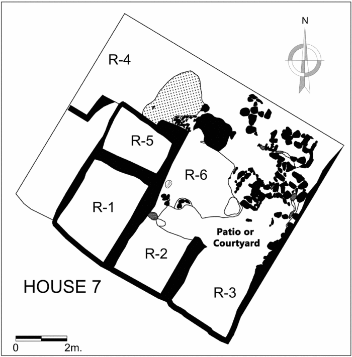
This house is located on the western side of the plaza (Figure 3), and the total surface area of this domestic structure was approximately 100 m2 (Figure 8). The presence of an enclosing wall distinguishes House 7 from Houses 1 and 2. The private rooms of the house were placed on the southwest corner of the enclosure. In Room 1, three human graves were carefully placed before this domestic structure was abandoned and backfilled. These three funerary contexts (T-103, T-104, and T-105) were located in the southeastern and the northwestern corners of the room. All three burials were identified as adult women between 30 and 50 years old, with markers of occupational stress related to weaving and basketry (Prieto Reference Prieto2015).
Map of House 7.

An isolated wall is present outside of the private rooms to the east of House 7. Other structures (Rooms 2 and 3) were built but may have been destroyed either prior to abandonment or during the process of backfilling this area. Within this sector, numerous shellfish remains were recovered, specifically clam shells and seabird bones. In addition, abundant plant fibers such as cotton and sedge were recovered, along with two wooden needles.
On the north sector of House 7 is an open space that was likely the patio of the house (Room 6). Numerous artifacts were recovered including stone net weights, cobblestones used to grind red pigment, clam shells used as red paint containers, and even cotton balls dyed in red. Perhaps the red cotton fabrics and threads found in this house and the other houses were colored in this patio. A large quantity of unspun cotton fiber (Gossypium sp.) was found, along with numerous remains of sedges (Furcraea sp.) and reeds (Scirpus sp.). Additionally, fragments of reed mats and fragments of possible baskets were discovered as well as two fragments of bone tools possibly used to process fibers. In the northeast corner of the excavated unit was a large whale vertebral disk that was possibly used to shape baskets. In one of the rooms of this house, a set of two stone pestles was carefully deposited. These lithic artifacts seem to have been bark beaters to process the sedge and reeds that were later transformed into items such as ropes, mats, and baskets. Based on the recurrence of fibers, fragments of mats and baskets, and tools related to basketry and matting activity in this house, I have previously suggested that the inhabitants of this house were involved in weaving cotton fabrics, basketry, as well as mat production. This is supported by the markers of occupational stress found on the bones of the three adult females buried in this house (Prieto Reference Prieto2014, Reference Prieto2015).
The Social Dynamics at Gramalote
Detailed excavation of these houses allows for exploration of more sophisticated questions about how these families were organized within a small residential settlement during the second millennium BC. Ethnographic data and information from other relatively contemporary sites suggest an average size of four to five members per nuclear family (Chu Reference Chu2008). Nevertheless, as is detailed below, it is quite possible that instead of a nuclear-family model at Gramalote, there was an extended-family model in which most of the members of the group lived together (Prieto Reference Prieto2015).
No distinctive pattern for layout of domestic house spaces is found at Gramalote. Each of the fully excavated houses shows a different plan, even when the houses are from the same occupational phase (Figures 6 and 8). As a general commonality, the people from Gramalote used a very small space for resting (usually rooms of 4–16 square meters) and large areas for food processing, consumption, and storage, as well as for nondomestic activities. The latter areas are usually triple the surface area of the resting spaces. Some patios, such as the one on the south side of House 1 or the patio of House 7, served for multiple activities, including processing (drying/salting) large quantities of marine resources for later consumption and/or for exchange with other contemporary settlements inland of the valley, for domestic rituals, and for manufacturing baskets and mats. The ample area given to these patios in the Gramalote houses demonstrates the importance of these food production activities in the daily praxis of this settlement. These patio areas were spaces of high production by members of the extended household. Social cohesion, gender inequality (defined by the exploitation of sea resources [see below]) domestic rituals, and the processing of marine products surplus were all performed in a shared space when the members of the house interacted in the patio areas. Therefore, it is proposed that at the site of Gramalote, the patios within the domestic house structures were the focus of the domestic activity and therefore the most important family space.
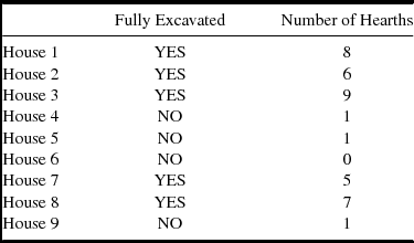
Processing of marine products far surpassed the needs required by a family unit. This idea is supported by the abundant food leftovers found in the fills that backfilled the houses. Archaeological evidence supports this, because each house patio had between three to eight circular stone hearths (Table 2). Why would the patios of Gramalote domestic structures have so many hearths? A plausible answer is the production of surplus. The standard household at Gramalote amassed more marine products than required for daily subsistence. For example, when certain resources were abundant in the nearby beaches due to the season or happenstance, the Gramalote extended household organized to effectively exploit those food resources. The resulting surplus then had to be processed for later consumption or for trade exchange with noncoastal contemporaneous settlements. It could also be argued that the presence of several hearths in the Gramalote houses indicates that members of an extended family used the same processing facilities. Therefore, the number of hearths per house can serve as an indicator of the number of members per household, as has been suggested in other archaeological contexts in the Andean region (Stanish Reference Stanish1989). Perhaps the entire group met at mealtimes or other significant moments to prepare and share the food that was obtained through the joint efforts of the extended family. Thus, preparation and consumption of food was probably a moment enriched by the interaction of all the members of the extended family, in which they shared their daily activities and experiences.
Number of Hearths per House (Complete and Incomplete, Excavated at Gramalote).

Patio areas of the domestic structures at Gramalote were not just used for food preparation, consumption, and as a resting place. A variety of nonsubsistence products were made at different houses. For example, on the patio of House 7, the presence of bone tools, stone pestles, abundant twisted sedges, and fragments of ropes and reed mats, suggests that the inhabitants of this domestic unit engaged in basketry and mat weaving. This is supported by markers of occupational stress on the arms and finger bones of the tree adult females buried within this house. House 2 seems to have specialized in the gathering of shellfish, because abundant bivalves and gastropods were recovered in and around this house. House 1 seems to have focused on hunting seabirds and the gathering and later drying of seaweed, based on the abundance of this resource in this house. At House 8 (not described in this article but see Prieto Reference Prieto2015), the inhabitants focused on processing gourds to make containers based on the abundance of gourd peduncles, seeds, and shells. This pattern suggests that although the Gramalote inhabitants shared a common economic base founded on a marine economy that exploited sharks, fish, sea mammals, and other resources to subsist, they additionally specialized in exploiting other marine resources and manufactured utilitarian goods for their own consumption, eventual exchange within their settlement, and perhaps exchange with other contemporaneous peer sites.
In summary, I propose that the social organization at Gramalote was not based on nuclear families but rather was organized as an extended household, and each group was likely led by the founding couples. This model is observed in traditional families of present-day Huanchaco (Gillin Reference Gillin1947; Hudson Reference Hudson, Albarella and Trentacoste2011). The extended family probably lived together, in houses with large patios serving as a space for their daily activities and small resting areas where all the members probably slept. The entire household worked as a group to obtain food for their daily maintenance but also to produce a surplus, which could have been used to establish contacts with other households at the site level and with other communities of the valley and the region.
The Household Economy at Gramalote
How did the household economy of a fishing community function during the second millennium BC on the North Coast of Peru? At Gramalote, all the households studied relied heavily on marine resources, mainly sharks (Prionace glauca, Isurus oxyrinchus, Mustelus sp., and Myliobatis peruvianus), large drums (Cilus gilberti and Robaloscion wieneri), sea mammals (mainly Otaria sp.), tubers (Ipomoea batata, Manihot esculenta and Solanum tuberosum), fruits (Pouteria lucuma and Persea americana), and legumes (Phaseolus vulgaris and Phaseolus lunatus; Prieto Reference Prieto2015).
It is possible that to increase production, the extended household was organized by gender to exploit marine resources. Today, the production of marine resources at Huanchaco is strongly defined by gender and age. Young and middle-aged men use reed boats for offshore fisheries, using nets and fishing lines to obtain fish, providing the bulk of daily meals. Young and middle-aged women gather seaweed, crabs, shells, gastropods, octopi, and other marine resources along the shoreline. Children help the adult females, while old males stay at home mending nets or fish from the shoreline using nets or hooks and lines. Old women stay at home weaving baskets or mats, drying fish, or preparing daily meals. Gender division of substance activities is maintained in the summer and winter. The previously detailed subsistence activities are common during the summer, when marine resources are abundant. When there is a relative scarcity of fish in the winter season, the exact nature of the activities change.
At Gramalote, during the summer, young and adult fishermen primarily engaged in shark and large drum fishing, including sea lion hunting, while the women were occupied gathering shellfish, especially the gastropods that are abundant along the shoreline during this season (Prieto Reference Prieto2015). During the winter season, the men of the community likely concentrated their efforts on fishing crabs offshore, using their reed boats and crab traps. It is possible that some men of the household were expert divers who could reach the deep, rocky bottoms where mussels dwell in colonies. During winter, the women gathered seaweed along the shoreline and collected the available shellfish, such as the pearly top shell (Tegula atra), among other species. Essentially, the abundant marine resources evidenced in the Gramalote deposits must be viewed as the result of two different kinds of diets, represented by the two seasons of the year. This seasonal model is currently supported by ethnographic observations of traditional fishermen in Huanchaco and their exploitation of marine resources. Subsequently, this seasonal model must be tested using isotopic values to determine water temperature variability on fish and shellfish species in addition to sclerochronological studies on selected shellfish species in the future.
Gramalote was not an isolated coastal site during the second millennium BC, and this is important to remember when it comes to interpreting the activities and daily praxis of the household dwellings. This site is less than a day's walk from the contemporaneous fishing communities of Guañape to the south, and Huaca Prieta to the north (Figure 1). Perhaps the exchange of various products was a good opportunity to meet new people, find future spouses, strengthen social alliances, or simply gain access to specific resources from the beaches. Longitudinal relations among fishing settlements were first noticed by Rostworowski (Reference Rostworowski1981), who used ethnohistorical documents proving the existence of these connections prior to the Spanish presence in the coast of Peru. In 1907, Robert Coker reported in Chimbote (124 kilometers south of present day Huanchaco), a small town known as “Huanchaquito” or “little Huanchaco,” so named because its inhabitants claimed to come originally from the fishing town of Huanchaco. Fishermen from this northern fishing town came to this area to fish and eventually established this town that was still inhabited in the early twentieth century (Coker Reference Coker2008:298). This ethnographic example suggests that longitudinal relations were not just fishing expeditions but perhaps led to the establishment of permanent residences, and thus new fishing settlements, along the Peruvian coast.
It raises the question of how the household structure operated to produce a surplus large enough to support year-round subsistence. Jean Hudson (Reference Hudson, Albarella and Trentacoste2011) describes the way a household of extended family members in modern Huanchaco works together to maximize production in daily sustenance activities. In essence, the whole family works as a cohesive entity to ensure the procurement and consumption of food and then the distribution and commercialization of the surplus. An interesting point made by Hudson is that all these efforts together produce a surplus for the family, which is used to buy other things they need for modern life, resources they cannot produce or afford without the surplus beyond the marine products used for daily consumption. Therefore, it can be proposed that the extended households at Gramalote worked together to obtain the surplus needed to acquire nonlocal resources.
Producing Surplus for Internal and External Demands: Generating Exchange of Subsistence Products for Social and Ceremonial Interaction
Using current ethnographic models and data obtained from the community of Huanchaco (Gillin Reference Gillin1947; Hudson Reference Hudson, Albarella and Trentacoste2011), it is not unreasonable to suggest the extended household model could have been the basis for social organization at this early maritime community during the Initial Period. Physical evidence suggests that this extended family model is evidenced in the proximity of the domestic houses at Gramalote, which is identical to the proximity of the houses of the extended households today at Huanchaco. House 1 is larger than House 2, and both are connected by an axial wall on the east side (Figure 6). Perhaps House 1 was the dwelling of the founding/head couple, and House 2 the residence of one of their siblings. As previously mentioned, both houses are next to each other and share a common space for preparing food. This is remarkably similar to modern households in the southern highlands, in which the modern hearths are shared between domestic structures (Stanish Reference Stanish1989). Similarly, Houses 5 and 6 (not described in this article) are in close proximity to one another, and both structures share common walls and food preparation areas (Figure 6). Although these houses were not as fully excavated as the two previously described, there seems to be a pattern of clustered houses at Gramalote sharing common food processing and preparation spaces. Furthermore, the presence of multiple hearths in the patio area of the houses suggests the existence of a close social relationship between the residents of the houses, who likely shared their meals and used this as a space where possibly entire extended families met during the day. This recommends the theory that extended households are physically represented in the residential architecture of Gramalote.
If the extended household model is accepted, it would be expected that after all the products were fished, gathered, or hunted, a significant part of the outcome was kept for daily consumption. The mechanism in which the food was distributed within the extended household is a matter of speculation, but one can refer to the modern accounts of how traditional fishermen in Huanchaco used to distribute their catch to the crew in boats (Gillin Reference Gillin1947:32). In this model, the fish from one fishnet is separated into two equal parts—one part for the owner of the net and the other half divided among each of the crew members. Applying this model to Gramalote, one can speculate that each fisherman from the extended household used part of his personal production for the maintenance of himself and his dependents, and the other part was commonly shared with the rest of the household members and potentially managed by the founding couple of the extended group to fulfill other social obligations within the community and for other nonlocal events (see below).
Under this model, there is no general surplus. Instead, each extended household controls its own surplus for their local obligations (maybe a coastal variation of the Quechua ayni) and other social needs (special family events, etc.). In a nonmonetized society, there is no need for wealth accumulation because production surplus serves to extend the social network of the household, at the same time enhancing its prestige through hosting or participating in ceremonial occasions. The surplus is then expended with other households to establish social links that strengthen the unity of the settlement as a whole.
During the excavations of the various houses at Gramalote, very few small storage facilities were found, suggesting that the inhabitants did not accumulate large quantities of marine resources, even when these resources were abundant at the nearby beaches. Indeed, there was no need for a massive accumulation of surplus at the household level. The lack of large storage facilities in the houses at Gramalote is strong evidence that household members during the Initial Period developed a subsistence exploitation of marine resources, which means that only the needed food for the day was gathered, fished, or hunted. This is further reinforced by the fact that marine products turn bad within hours, and it is difficult to store them in a humid environment. Although it is obvious that a great part of the marine resources was dried and salted for later consumption, it seems that fresh food was preferred for daily consumption. In preparation for special occasions or during the period of abundance for certain marine species, the extended household could work together to create the necessary surplus for their later maintenance or for their social needs in relation to other households and for exchange with other contemporary settlements in their valley and region.
The Gramalote Settlement Beyond Its Boundaries
The large span of subsistence and nonsubsistence activities undertaken at Gramalote suggests that the community was largely self-sufficient. Nonetheless, they needed a number of goods that they themselves did not produce. From utilitarian ceramic wares to cotton fabrics, it is possible that these products were obtained through trade with nearby and more distant contemporaneous communities. Preliminary petrographic analyses of the domestic ceramic vessels found at Gramalote suggest that they came from the mid-upper valley where the potters had direct access to the rough temper used in manufacturing these artifacts (Druc and Prieto Reference Druc and Prieto2016). Various nonlocal edible plants, especially tubers such as potatoes, sweet potatoes, and manioc were essential to their diet. All the samples analyzed from lithic artifacts and ceramic vessels showed residues of these nonlocal products (Prieto Reference Prieto2015). Beyond the economic transactions is the common and natural human interest in meeting new people and large communal gatherings with other peers. How and when did the Gramalote inhabitants exchange their products with other contemporary settlements?
Both marine products (dried/salted fish, shellfish, and seaweed) and nonsubsistence goods produced at Gramalote, such as gourds, carved bones, basketry, shell beads, and red pigment, suggest a local demand but also a high probability of external exchange with other contemporaneous settlements where these products and food were not available. Today, we do not know much about the economy of the so called “farming” communities, but they likely manufactured a wide range of nonsubsistence products such as ceramic vessels, stone bowls and tools, anthracite mirrors, and cotton fabrics, judging by the implicit availability of the natural resources in the vicinity required to produce these goods. This surplus of food and manufactured products made at the household level in different small residential settlements could have been the source of frequent economic interchange and social interaction between these sites.
If Initial Period fishing and farming communities are viewed as independent settlements, without an authoritarian redistributive system, how did they obtain and exchange their products? I suggest an alternative explanation to the asymmetrical exchange model previously proposed by Shelia and Thomas Pozorski (Reference Pozorski and Pozorski1979). The Pozorskis argue that small-scale residential settlements such as Gramalote might have been subsidiaries or even colonies (of the inland ceremonial center of Caballo Muerto) established to ensure a continuous supply of marine products for the inland complex (Pozorski and Pozorski Reference Pozorski and Pozorski1979:430).
Today, fishing settlements from the Moche valley go annually to the Fiesta del Señor de la Piedad at Simbal in the Middle Moche valley. They camp outside the town and for two days prior to the dia central de la fiesta, they exchange their products with local farmers and others from the upper highlands. In 2012, I was able to visit this fiesta and took ethnographic notes. Coastal fishermen and local producers take their places in the corners of the plaza of the town or in the marketplace. Then, the upper highlanders walk around them bringing commodities such as cereals and potatoes. Highlanders seek fruits, peppers, coca, salt, dry and salted fish, dry seaweed, and clean shells to produce high-quality lime. In exchange, fishermen and local farmers get potatoes, oca (native tuber), wool, wheat, and chuño (processed dried potatoes). Although this is a modern event that happens in the context of a Catholic festival, it is interesting that a similar pattern has been reported by Rostworowski for the Lurin valley during the Colonial Period (Rostworowski Reference Rostworowski1981). Elizabeth Hart recounts that early in the 16th century, fishermen from the Moche valley went up to the town of Simbal to exchange their fish for other products (Hart Reference Hart1983). Thus, it is very possible that the modern celebration of Señor de la Piedad is rooted in a Prehispanic tradition that involved gathering communities from different ecological zones to exchange their products in the context of religious festivities.
Although it is very difficult to prove that it goes back to the second millennium BC, I would like to propose the “Simbal Model.” The Simbal Model argues that small-scale residential settlements gathered around inland monumental centers for annual or other periodic celebrations. On those occasions, these communities were able to exchange their food and nonsubsistence products as well as to get access to different people, costumes, and beliefs.
Under the Simbal Model, social gatherings could create a unique situation in which multiple communities freely congregate around ceremonial centers and are not under the repressive shadow of authoritarian rulers who send them away to build irrigation canals and new staircases for the ceremonial platforms. Instead, the open social interaction of these communities around ceremonial centers fosters the exchange of ideas and new experiences relevant to their daily praxis. For example, discussion of new agricultural techniques could address how much water is required for manioc cultivation, which soil is best for production, or even more simple matters such as how many plants or how close to each other should you plant in a given plot. Fishermen could talk about baits and different technologies for manufacturing better fishhooks, their experiences watching the relationship between the moon and the tides, or the presence of certain birds and specific fish shoals in the sea. These are things that are not discussed by priests or chiefs, but certainly by the common people, those who are committed to their day-to-day tasks and enjoy being the most productive farmers or the most successful fishermen. One would expect that year after year, the people congregated around ceremonial centers during specific events throughout their calendars, indirectly modeling and improving life conditions within the domestic communities of the Moche Valley. From this standpoint, ceremonial centers played a central role in gathering people from different communities for economic and social transactions in a ceremonial context (Burger and Salazar-Burger Reference Burger, Salazar-Burger and Seki2014).
In this sense, Gramalote inhabitants were open to social interactions, both within their immediate territory and as part of larger gatherings hosted in the monumental ceremonial temples of the valley. There is no evidence that the Gramalote settlement was forced, as subjected people, to attend these regional events. The necessity of exchanging their marine products for other goods critical for their subsistence (carbohydrates, ceramic vessels, cloth) fostered social encounters as part of ceremonial festivities at which the people of Gramalote had the chance to meet populations from other settlements. The large spaces between the mounds of the contemporary ceremonial centers such as Caballo Muerto could have been venues for such encounters. We are far from demonstrating this model in the physical archaeological evidence, but it is an alternative explanation that could help understand social and economic relationships between small residential settlements and the ceremonial centers during the second millennium BC in the North Coast of Peru.
The Gramalote Settlement in a Larger Exchange Network
There is ample evidence of long-distance exchange between Gramalote and other regions of the Central Andes. Previously, Prieto and colleagues demonstrated through isotopic analysis that cinnabar pigment found in various artifacts at Gramalote came from an ore mined in the geological deposit of Huancavelica, located roughly 4,000 m above sea level and some 1,000 km to the southeast of the Moche Valley (Prieto et al. Reference Prieto, Wright, Burger, Cooke, Zeballos-Velasquez, Watanave, Suchomel and Suescun2016). It is plausible that the Gramalote inhabitants obtained this exotic element directly from the source, or more likely through direct contact with contemporaneous highland communities who in turn had access to settlements associated with the people who directly mined the cinnabar ore at Huancavelica. During the second millennium BC, cinnabar may have been passed hand to hand along an interconnected network of independent highland and coastal communities, which were constantly exchanging subsistence products and other manufactured goods (Prieto et al. Reference Prieto, Wright, Burger, Cooke, Zeballos-Velasquez, Watanave, Suchomel and Suescun2016). Similarly, the massive presence of anthracite artifacts at Gramalote may reflect direct contact with highland communities in the North Coast region where anthracite ores are common. Currently we are conducting ICP-MS analysis of beads made of a green mineral found at Gramalote to determine whether or not they were made using local copper ores. Preliminary results do not match copper ores located in the Moche Valley, suggesting that the raw material came from a distant region (Prieto Reference Prieto2015). In this light, Gramalote was a dynamic group interacting not only with local neighbors, but with an extended network of contemporary communities along the Andean region.
Final Thoughts
The spatial distribution of the houses and public areas at Gramalote shows an advanced notion of social organization. They built a public plaza where they performed ritual activities and also used the open space for production activities such as processing marine resources. None of the domestic house dwellings share a similar layout. The patios seem to have played a pivotal role in the internal dynamics of the households at Gramalote. In these spaces, they expressed the social organization of the settlement and performed the most important daily activities critical for the maintenance and continuity of the settlement. It is possible that each Gramalote household was engaged in developing specific nonsubsistence products such as baskets, dried seaweed, and carved gourds, both for local demand and for later external exchange. Instead of being a subsidiary colony or a food station as previously proposed, Gramalote and certainly almost all contemporaneous coastal and inland small-scale settlements may have been independent sites with a wide range of nonsubsistence activities which were crucial for social and economic purposes. Thus, under the Simbal Model, second millennium BC inland ceremonial centers were free congregational spaces for social dynamics and economic interactions, rather than authoritarian and repressive entities, in where common people forged the so-called path toward social complexity in this part of the Americas.
Acknowledgments
The excavations at the Gramalote site were supported by the Albers Funds of the Department of Anthropology at Yale, the Doctoral Dissertation Fieldwork Grant of the MacMillan Center, the John F. Enders Fellowship and the Institute of Agrarian Studies, all at Yale University. Special thanks to Richard Burger, my professor and friend, who encouraged me to work at Gramalote. This project was also made possible thanks to the Wenner-Gren Foundation (Dissertation Fieldwork Grant #8427), the National Geographic Society/Waitt Grants Program (Grant #W188-11) and the Sigma Xi Research Grants (Grant #G20110315156259). Current analyses on the archaeological collections found at Gramalote are supported by Beca de Repatriacion de Investigadores Peruanos at Universidad Nacional de Trujillo (Contrato #354-15) of the Programa Nacional INNOVATE Peru, Ministerio de la Produccion del Peru.
Data Availability Statement
Materials collected by the Gramalote Archaeological Project and the Huanchaco Archaeological Program between 2010 and 2016 are stored at Universidad Nacional de Trujillo, Peru. Original hard copy, digital field records, and photographs are in possession of the author at Universidad Nacional de Trujillo. Photos and tables are available open access in Prieto 2015.