1. Introduction
The Stanner Hanter Complex of the Welsh Borderland represents one of a small number of fault-bounded units that make up the record of exposed crystalline basement of Britain, south of the Iapetus Suture. An Rb–Sr isochron age of 702 ± 8 Ma presented by Patchett et al. (Reference Patchett, Gale, Goodwin and Humm1980) suggested the complex to be the oldest of these tectonic inliers. This paper presents a new, high resolution U–Pb age on zircon from the complex which, in combination with accompanying new Sm–Nd data, has resulted in a greater understanding of the affinities of basement terranes in southern Britain.
2. Regional tectonic framework
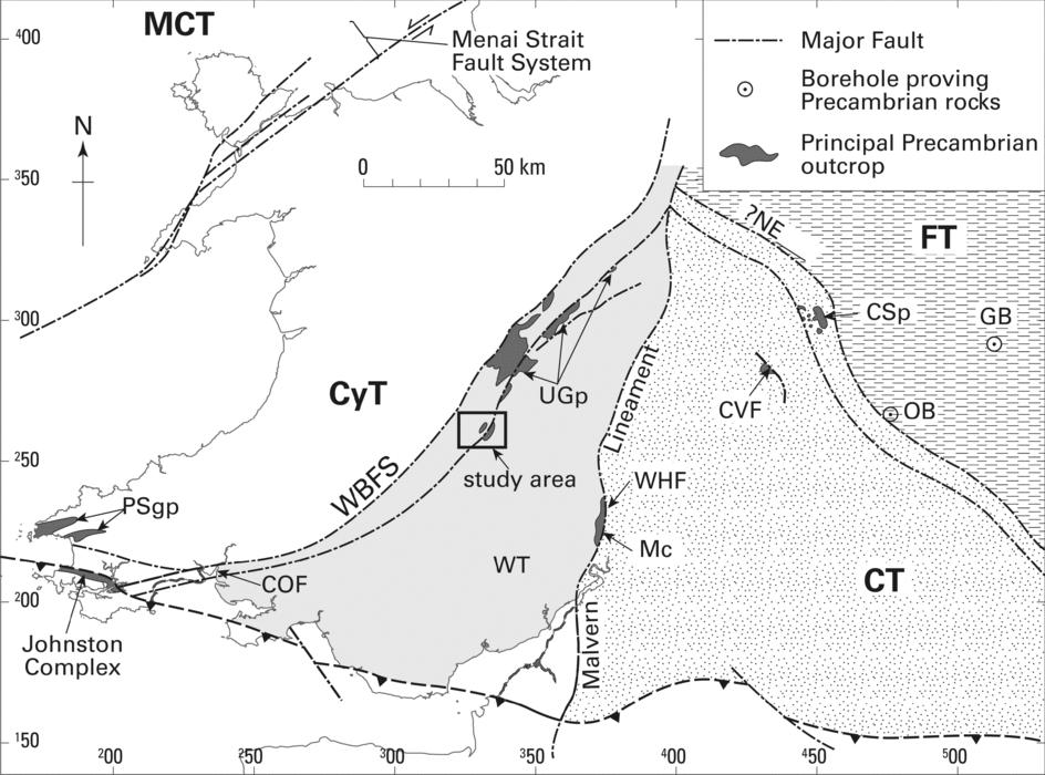
The Neoproterozoic basement of England and Wales is generally considered to comprise a collage of terranes that formed in close proximity to each other as component parts of the peri-Gondwanan eastern Avalonia microcontinent (e.g. Keppie et al. Reference Keppie, Nance, Murphy and Dostal2003; Strachan et al. Reference Strachan, Collins, Buchan, Nance, Murphy and D'Lemos2007). Individual terranes described by Pharaoh et al. (Reference Pharaoh, Webb, Thorpe, Beckinsale, Pharaoh, Beckinsale and Rickard1987) and Pharaoh & Carney (Reference Pharaoh, Carney, Carney, Horák, Pharaoh, Gibbons, Wilson, Barclay and Bevins2000) include, from west to east, the Monian Composite Terrane, the Cymru Terrane, the Wrekin Terrane, the Charnwood Terrane and the Fenland Terrane (Fig. 1). Their existence as discrete tectonostratigraphic entities is largely predicated on the presence of a series of significant structural lineaments, interpreted as terrane boundaries, supported by contrasts in the geochemical characteristics of volcanic successions entrained as tectonic inliers within them (Pharaoh et al. Reference Pharaoh, Webb, Thorpe, Beckinsale, Pharaoh, Beckinsale and Rickard1987). The upper crustal expressions of the structural lineaments are marked by broad zones of faulting, including the Menai Straits Fault Zone, Welsh Borderland Fault System and Malvern Lineament (Fig. 1). Neoproterozoic basement rocks have also been proven in a limited number of deep boreholes (e.g. Allen & Jackson, Reference Allen and Jackson1978; Noble, Tucker & Pharaoh, Reference Noble, Tucker and Pharaoh1993; Barclay et al. Reference Barclay, Ambrose, Chadwick and Pharaoh1997; Pharaoh et al. Reference Pharaoh, Merriman, Evans, Brewer, Webb and Smith1991).
Terrane map of southern Britain after British Geological Survey (1996) and Pharaoh & Carney (Reference Pharaoh, Carney, Carney, Horák, Pharaoh, Gibbons, Wilson, Barclay and Bevins2000). MCT – Monian Composite Terrane; FT – Fenland Terrane; CT – Charnwood Terrane; WT – Wrekin Terrane; CyT – Cymru Terrane; CSp – Charnian Supergroup; CVF – Caldecote Volcanic Formation; WHF – Warren House Formation; Mc – Malverns Complex; UGp – Uriconian Group; COF – Coombe Volcanic Formation; PSgp – Pebidian Supergroup; NECBF – NE Charnwood Boundary Fault; WBFS – Welsh Borderland Fault System; GB – Glinton borehole; OB – Orton borehole. Box shows approximate location of Stanner Hanter Complex as illustrated in Figure 2. Co-ordinates are British National Grid.

The terranes themselves are thought to have formed during cycles of arc-related magmatism and sedimentary deposition. Together these make up part of the record of assembly of West Gondwana at around 765–660 Ma and 635–550 Ma (Nance, Murphy & Keppie, Reference Nance, Murphy and Keppie2002; Nance et al. Reference Nance, Murphy, Strachan, Keppie, Gutiérrez-Alonso, Fernández-Suárez, Quesade, Linnemann, D'Lemos, Pisarevsky, Ennih and Liégeois2008 and references therein). This included accretion of Avalonian-type and Ganderean-type terranes against a composite West Africa–Amazonia–Baltica margin of Gondwana (Murphy et al. Reference Murphy, Pisarevsky, Nance and Keppie2004; Nance et al. Reference Nance, Murphy, Strachan, Keppie, Gutiérrez-Alonso, Fernández-Suárez, Quesade, Linnemann, D'Lemos, Pisarevsky, Ennih and Liégeois2008), recorded in southern Britain as the c. 667–650 Ma metamorphic event (Strachan et al. Reference Strachan, Nance, Dallmeyer, D'Lemos, Murphy and Watt1996, Reference Strachan, Collins, Buchan, Nance, Murphy and D'Lemos2007). Available isotopic data suggest that the Avalonian terranes of southern Britain were assembled together by latest Precambrian to Early Cambrian times (Gibbons & Horák, Reference Gibbons, Horák, Nance and Thompson1996; Strachan et al. Reference Strachan, Collins, Buchan, Nance, Murphy and D'Lemos2007).
However, the data from southern Britain in support of this tectonic assembly model are very limited, both in terms of paucity and distribution of exposure and antiquity of some of the isotopic studies. Indeed, the terrane boundaries in southern Britain, within which many of the Late Neoproterozoic rocks are entrained, are understood to be long-lived structures influenced by several accretionary cycles (e.g. Woodcock & Gibbons, Reference Woodcock and Gibbons1988; Kawai et al. Reference Kawai, Windley, Terabayashi, Yamamoto, Maruyama, Omori, Shibuya, Sawaki and Isozaki2007; Schofield et al. Reference Schofield, Evans, Millar, Wilby and Aspden2008). Consequently, considerable scope exists for a more complex assembly process in which disparate geological elements may have been combined and intercalated over a long period of geological time. Accordingly, this study, based on new isotopic data from the Stanner Hanter Complex, represents part of an ongoing reappraisal of the terrane affinities of southern Britain.
3. Geology of the Stanner Hanter Complex
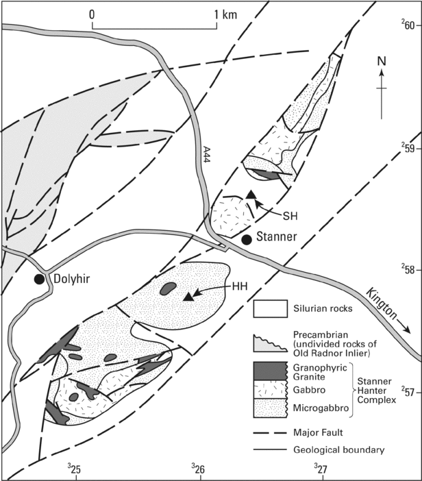
The Stanner Hanter Complex forms an inlier of intrusive igneous rocks cropping out west of the village of Kington in the Welsh Borderland (Fig. 1). It is contained within splays of the Church Stretton Fault, part of the Welsh Borderland Fault System (WBFS), and was considered an exposure of the basement to the Wrekin Terrane by Pharaoh et al. (Reference Pharaoh, Webb, Thorpe, Beckinsale, Pharaoh, Beckinsale and Rickard1987). Although contacts are poorly exposed, the inlier is interpreted to be overstepped by strata of Silurian age on its southern and eastern margin, but faulted along its northern contact (Holgate & Hallowes, Reference Holgate and Hallowes1941; Fig. 2).
Geological map of the Stanner Hanter Complex (after Holgate & Hallowes, Reference Holgate and Hallowes1941; Woodcock, Reference Woodcock1988). Filled triangles indicate the summits of Hanter Hill (HH) and Stanner Hill (SH). Co-ordinates are British National Grid.

The Church Stretton Fault makes up the easternmost strand of the Welsh Borderland Fault System, part of a plexus of structures that mark the transition from thick basinal deposits of the Lower Palaeozoic Welsh Basin to the west to the condensed sequences of the Midland Platform to the east (Woodcock & Gibbons, Reference Woodcock and Gibbons1988). The fault is thought to preserve a long history of movement, including a significant inferred component of transcurrent displacement (Woodcock, Reference Woodcock1988). Fault reactivation during the Early Palaeozoic appears to have strongly influenced sedimentation in the region; indeed the angular unconformity between Longmyndian and overlying Cambrian rocks of the nearby Wrekin hills (see below) provides evidence for probable Late Neoproterozoic movements (Greig et al. Reference Greig, Wright, Hains and Mitchell1968), while an angular sub-Wenlock unconformity has been taken to indicate an episode of pre-Acadian (Early- to Mid-Devonian), probably Late Ashgill-age, tectonism (Woodcock, Reference Woodcock1988; Woodcock & Gibbons, Reference Woodcock and Gibbons1988).
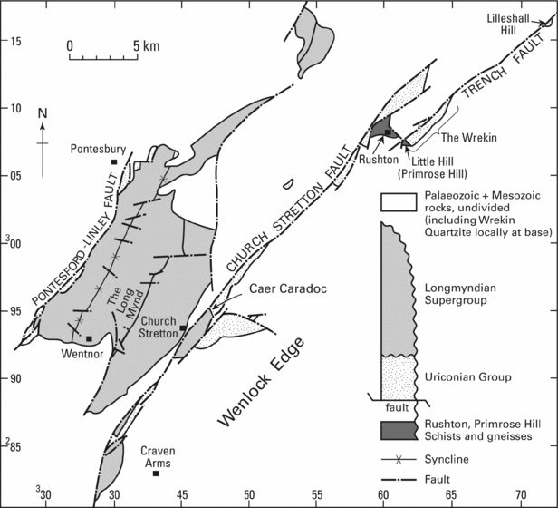
Along strike to the northeast, the Church Stretton and Pontesford Linley faults (or Pontesford Lineament, a basinward strand of the Welsh Borderland Fault System) enclose additional Neoproterozoic to Early Cambrian age inliers (Fig. 3), which along with the Malvern Complex to the east make up the entire exposure of the proposed Wrekin Terrane (Fig. 1). Recent interpretations (Pharaoh & Carney, Reference Pharaoh, Carney, Carney, Horák, Pharaoh, Gibbons, Wilson, Barclay and Bevins2000) treat the units enclosed by the Welsh Borderland Fault System as a single tectonostratigraphic succession in which the Stanner Hanter Complex preserves the oldest isotopic age. The nearby Rushton Schist is reported to have a younger Rb–Sr whole rock isochron age of 667 ± 20 Ma (Thorpe et al. Reference Thorpe, Beckinsale, Patchett, Piper, Davies and Evans1984), which along with the Primrose Hill Gneiss have been interpreted as metamorphosed sedimentary remnants of unknown protolith age.
Geological map of the Wrekin terrane inliers after Pauley (Reference Pauley1991) and Pharaoh & Carney (Reference Pharaoh, Carney, Carney, Horák, Pharaoh, Gibbons, Wilson, Barclay and Bevins2000). Co-ordinates are British National Grid.

Adjacent to these, also located within splays of the Church Stretton Fault, are a succession of acid, intermediate and basic tuffs and lavas of the Uriconian Group and intrusive Ercall Granophyre (Fig. 3). Rhyolite from the former has yielded a U–Pb age of 566 ± 2 Ma, while the Ercall Granophyre has been dated at 560 ± 1 Ma (Tucker & Pharoah, Reference Tucker and Pharoah1991). The Uriconian Group is overlain by a 6500 m thick succession of the Longmyndian Supergroup which has yielded a U–Pb age from tuff and bentonite within the succession of 555.9 ± 3.5 Ma (Compston, Wright & Toghill, Reference Compston, Wright and Toghill2002). Although the nature of their relationship has been the matter of some debate, James (Reference James1952, Reference James1956) argued that the presence of volcanic clasts similar to Uriconian lithologies demonstrated an unconformable relationship between the two. The youngest rocks of the Wrekin Terrane are represented by a succession of Early to Middle Cambrian sedimentary rocks, the Wrekin Quartzite and Lower and Upper Comley sandstones. The Wrekin Quartzite comprises approximately 50 m of indurated shoreface sands (Wright et al. Reference Wright, Fairchild, Moseley and Downey1993), which were recognized by Callaway (Reference Callaway1879) and Cope & Gibbons (Reference Cope and Gibbons1987), on the basis of derived volcanic pebbles, as unconformably overlying the Uriconian Group. The age of the Wrekin Quartzite is poorly constrained to a Placentia Series age (approximately 543–520 Ma) on the basis of a sparse shelly fauna (Brasier, Reference Brasier, Cowie and Brasier1989), while the overlying Lower and Upper Comley sandstones have yielded a more extensive fauna spanning Branch to St David's series ages (approximately 520–510 Ma; Rushton, Hamblin & Strong, Reference Rushton, Hamblin and Strong1988; Greig et al. Reference Greig, Wright, Hains and Mitchell1968).
The Stanner Hanter Complex comprises an assemblage of igneous rocks, dominated by basic lithologies but containing significant intermediate and acid components. Lithologies are generally highly altered and the complex itself is dissected by numerous faults (Fig. 2). Pocock & Whitehead (Reference Pocock and Whitehead1935) recognized similarities with the nearby Uriconian Group, although subsequent dating (Tucker & Pharoah, Reference Tucker and Pharoah1991) has shown it to be significantly younger than the Stanner Hanter Complex. Holgate & Hallowes (Reference Holgate and Hallowes1941) recognized a four-fold division of sequentially emplaced lithologies, whereas Jones (Reference Jones, Carney, Horák, Pharaoh, Gibbons, Wilson, Barclay and Bevins2000) identified the importance of magma mixing in the assembly of the complex. The oldest component, a fine-grained microgabbro, is interpreted as having intruded into an unspecified host rock as a series of sills (Jones, Reference Jones, Carney, Horák, Pharaoh, Gibbons, Wilson, Barclay and Bevins2000) and forms the majority of the exposure of the inlier. These were intruded by an array of coalesced, dyke-like gabbro sheets with prominent chilled margins. A larger gabbro body, exposed on Hanter Hill, has a low-angled basal contact, preserves compositional layering which becomes considerably more leucocratic toward the top, and was considered by Jones (Reference Jones, Carney, Horák, Pharaoh, Gibbons, Wilson, Barclay and Bevins2000) as a remnant section through a small magma chamber. Jones (Reference Jones, Carney, Horák, Pharaoh, Gibbons, Wilson, Barclay and Bevins2000) also interpreted interaction of the gabbroic facies with the final phase of narrow sheets of locally porphyritic, biotite microgranite containing abundant microgabbro xenoliths with strongly cuspate margins to indicate magma mixing and mingling. A phase of tourmaline mineralization within the main gabbro body has also been linked to the intrusion of the final granitic intrusive phase (Holgate, Reference Holgate1977). Hydrous alteration of all the magmatic facies is widespread.
4. Isotope analysis
Zircon grains were separated from a sample of granophyric granitic rock from the Stanner Hanter Complex. The sample was collected from a small unit of the intrusive biotite microgranite facies exposed on the flanks of Hanter Hill [325253 257860]. The separated zircons were chemically abraded (Mattinson, Reference Mattinson2005) and analysed at the NERC Isotope Geoscience Laboratories (NIGL), following the procedures of Noble, Tucker & Pharaoh (Reference Noble, Tucker and Pharaoh1993). Chemistry blanks were ~ 2 pg, and uranium blanks were < 0.1 pg U. All results and errors were calculated following the methods of Ludwig (Reference Ludwig1993) and plotted using Isoplot/Ex (Ludwig, Reference Ludwig2003). Pb isotope ratios were corrected for initial common Pb in excess of laboratory blank using the model of Stacey & Kramers (Reference Stacey and Kramers1975). Results were calculated using the decay constants of Jaffey et al. (Reference Jaffey, Flynn, Glendenin, Bentley and Essling1971). Sm–Nd whole-rock analyses were also carried out at NIGL on two further samples from the complex, one of granitic rock sampled from Hanter Hill [324791 256845] and one of gabbro collected from nearby Stanner Rocks [32617 3258282]. Data for both U–Pb and Sm–Nd analyses are presented in Appendix Tables A1 and A2, respectively, available as supplementary material online at http://multimediafluids.uam.elogim.com/journals/geo.
5. Discussion
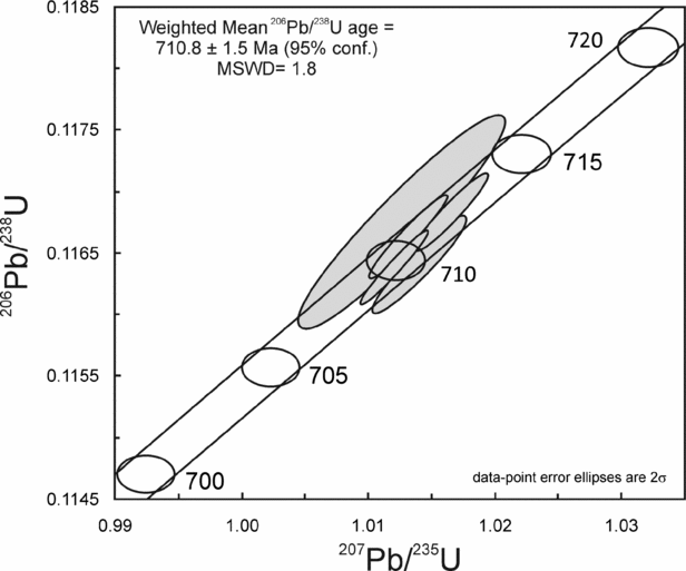
Of six analysed zircon fractions, one is highly discordant, with a 207Pb/206Pb model age of c. 1035 Ma, indicating the presence of an inherited component. The remaining five grains lie on concordia, and give a weighted mean 206Pb/238U age of 710.8 ± 1.5 Ma (95 % confidence limits), which is interpreted to reflect the crystallization age of the latest, granitic facies of the complex (Fig. 4). This age is similar to, and just within error of, the 702 ± 8 Ma Rb–Sr isochron age of Patchett et al. (Reference Patchett, Gale, Goodwin and Humm1980), yielded from granitic rocks collected from the adjacent Stanner Hill, and suggests that the latter age also approximates to the age of crystallization of that facies.
U–Pb concordia plot showing data from six zircon fractions. The error quoted on the age includes decay constant errors and the MSWD incorporates concordance and equivalence.

The new zircon age confirms that the Stanner Hanter Complex therefore remains the oldest known outcrop of the crystalline basement of southern Britain. The complex also appears to have largely been unaffected by subsequent thermal events within the Wrekin Terrane, such as the c. 667 Ma metamorphic event preserved in the Rushton Schist, and 667–650 Ma metamorphic event preserved in the nearby Malverns Complex (Strachan et al. Reference Strachan, Nance, Dallmeyer, D'Lemos, Murphy and Watt1996, Reference Strachan, Collins, Buchan, Nance, Murphy and D'Lemos2007).
Much of both western and eastern Avalonia is dominated by arc magmatic rocks ranging between 635 and 550 Ma in age (Nance, Murphy & Keppie, Reference Nance, Murphy and Keppie2002). Importantly, the new age data from the Stanner Hanter Complex confirms that it represents one of a dispersed number of magmatic relicts that together record an older, c. 765 to 650 Ma, cycle of arc magmatism (Nance, Murphy & Keppie, Reference Nance, Murphy and Keppie2002) that critically relates the basement of southern Britain to other Avalonian-type terranes preserved along the Caledonian–Appalachian Orogen. Examples from the Avalonian terrane of southern Newfoundland include: c. 687–670 Ma calc-alkaline volcanic rocks of the Tickle Point Formation and Furbys Cove Intrusive Suite (Swinden & Hunt, Reference Swinden and Hunt1991; O'Brien et al. Reference O'Brien, O'Driscoll, Greene and Tucker1995); the c. 680 Ma Cinq Cerf–Grey River gneiss terrane (Dunning & O'Brien, Reference Dunning and O'Brien1989; Valverde-Vaquero, Dunning & O'Brien, Reference Valverde-Vaquero, Dunning and O'Brien2006); the c. 760 Ma Burin Group (Murphy et al. Reference Murphy, McCausland, O'Brien, Pisarevsky and Hamilton2008); and c. 730 Ma felsic magmatic rocks of the Holyrood Horst on the Avalon Peninsula (O'Brien et al. Reference O'Brien, Dunning, Dubé, O'Driscoll, Sparkes, Israel and Ketchum2001). Early arc complexes of Nova Scotia include: the c. 676 Ma Stirling Belt (Bevier et al. Reference Bevier, Barr, White and Macdonald1993); the c. 700–630 Ma volcanic rocks of the Creignish Hills (Keppie & Dostal, Reference Keppie and Dostal1998); the c. 734 Ma calc-alkaline Economy River Gneiss (Doig, Murphy & Nance, Reference Doig, Murphy and Nance1993); and the proposed back-arc basin succession of the Gamble Brook Formation (Murphy, Reference Murphy2002). Beyond Avalonia, this phase of arc magmatism has been recorded by the c. 746 Ma Pentevrian Complex of the Cadomian Terrane in France (Egal et al. Reference Egal, Guerrot, Le Goff, Thieblemont, Chantraine, Nance and Thompson1996).
ϵNd values of −0.3 (gabbro) to −1.2 (granitic rock) from the complex are slightly lower than estimated bulk earth compositions. Because ancient crustal material evolves toward negative ϵNd, the implication of these data is that the Stanner Hanter magmas were generated either by reworking of pre-existing crust, or mixing of contemporary mantle-derived magma with much older crustal material. In the first case, TDM of 1393 Ma and 1469 Ma, respectively, for the two samples would approximate to the age for that source material. However, when taken together with analyses from the Orton and Glinton boreholes of the Fenland Terrane, which have yielded ϵNd values of −4.03 to −4.46 and TDM ranging from 1614 Ma to 1644 Ma (two-stage depleted mantle model ages, recalculated from Noble, Tucker & Pharaoh, Reference Noble, Tucker and Pharaoh1993), the Sm–Nd data suggest that mixing of c. 700 Ma mantle-derived magmas with a more ancient, Palaeoproterozoic or Archaean, source component is more likely. The analysed sample from the Stanner Hanter Complex contained one highly discordant zircon grain (online Appendix Table A1), which, if regressed through the intrusion age of 710.8 ± 1.5 Ma, yields an upper intercept age of c. 1648 Ma. Clearly, little weight can be placed upon such highly discordant data, but this at least confirms the presence of more ancient crustal material in the Stanner Hanter granite.
These data contrast with typical values for Neoproterozoic igneous rock from the western Avalonian terranes of Newfoundland and Nova Scotia, which typically have positive ϵNd values and TDM < 1.0 Ga (e.g. Murphy et al. Reference Murphy, Strachan, Nance, Parker and Fowler2000). Previous studies (e.g. Nance & Murphy, Reference Nance and Murphy1994; Murphy et al. Reference Murphy, Strachan, Nance, Parker and Fowler2000) have argued against the presence of ancient basement as a source component to the Avalonian terranes, favouring derivation from relatively juvenile ‘Grenvilian’ age, c. 1 Ga, island arcs or ocean plateaux formed during the assembly of the supercontinent of Rodinia. A more detailed study of the age distribution of inherited zircon in the Stanner Hanter granite would be required to test for the presence of such Grenville-aged material.
Some Late Neoproterozoic palaeogeographic reconstructions (e.g. Murphy et al. Reference Murphy, Strachan, Nance, Parker and Fowler2000) indicate that eastern Avalonia formed adjacent to the West African Craton. The latter is largely characterized by magmatic rocks formed during the c. 2.1 Ga Eburnean orogenic cycle as well as older, Archaean phases of crustal growth and accretion. Continental crust of this age is therefore the most likely potential source component contributing to the evolved Sm–Nd characteristics of the Late Neoproterozoic magmas of eastern Avalonia. Although not exposed in southern Britain, remnants of cratonic basement are preserved in other peri-Gondwanan terranes also thought to have originated adjacent to the West African Craton terranes. These include the c. 2.1 Ga Icartian Gneiss and Svetlik Gneiss of Cadomia (Samson & D'Lemos, Reference Samson and D'Lemos1998) and Bohemia (Wendt et al. Reference Wendt, Kröner, Fiala and Todt1993), respectively. Indeed, the Stanner Hanter rocks lie within the range of isotopic compositions for mixed source granitic magmas from Cadomia (ϵNd values of +1.6 to −1.9 and TDM ranging from 1.0 to 1.9 Ga; D'Lemos & Brown, Reference D'Lemos and Brown1993) and illustrate the potential input of an ancient crustal source of similar age. Alternative palaeogeographic reconstructions (e.g. Samson et al. Reference Samson, D'Lemos, Miller and Hamilton2005; Strachan et al. Reference Strachan, Collins, Buchan, Nance, Murphy and D'Lemos2007) suggest that Avalonia was further around the Gondwanan margin, adjacent to the Amazon Craton, during Late Neoproterozoic times. This region is in part distinguished from the West African Craton by the presence of Mesoproterozoic belts ranging from around 1.6 to 1.0 Ga in age (e.g. Tassinari & Macambira, Reference Tassinari and Macambira1999), which overlap with the TDM values from eastern Avalonia and provide another potential crustal source region to the Stanner Hanter Complex.
In conclusion, it should be noted that apparent fundamental isotopic differences in source composition between eastern and western Avalonia highlighted by these new data are balanced against similar, bi-partite cycles of arc magmatism and accretion that distinguish the Avalonian type from other peri-Gondwanan terranes (Keppie et al. Reference Keppie, Nance, Murphy, Dostal, Dallmayer and Lecorché1991). These data show that a more thorough investigation of the terrane and palaeogeographic affinities of eastern Avalonia is called for, requiring a more comprehensive isotopic dataset than is currently available.
Acknowledgements
D. I. Schofield and P. R. Wilby publish with the permission of the Executive Director, British Geological Survey.