

KRANE AND NEA KRANE
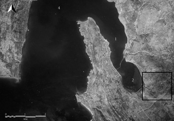
The ancient city of Krane occupies a large plain located on the south-eastern edge of the bay of Argostoli (Fig. 1:1). The site is on the shores of the Koutavos lagoon (2), the terminal part of the bay nowadays divided from the open sea by a bridge built in 1813. The bay is an excellent natural harbour, shielded from winds by hills and mountains on each side. Even today, the traveller navigating through the gulf (4) from Lixouri to modern Argostoli (3) may notice how, as the ferry enters the basin, the breeze becomes gentler and the sea calmer.
Location of Krane (in the square) and modern Argostoli (3). Elaboration of frame BSA P3 5003 (13 October 1943, scale of the original print 1:56,000, reproduced with permission from the British School at Athens).

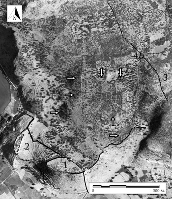
The site of Krane has been the subject of attention since the late nineteenth century, when it was recorded by Joseph Partsch (Reference Partsch1890, 80–4, pl. 2). Partsch mapped both the enceinte, which enclosed the western acropolis on the hill of Kastelli (Fig. 2:1) and the eastern hill of Pezules (Fig. 2:2), and the Early Hellenistic walls (Fig. 2:3) of a planned new city, with a so-called Dipylon Gate which has been interpreted as modelled on that in Athens (Fig. 2:4). Subsequent studies and excavations have shed light on the sequence of human activity in the area from the Early Bronze Age (EBA) onward.Footnote 1 Two sections of rubble wall have been ascribed to the EBA (Randsborg Reference Randsborg2002, vol. 2, 275, fig. IX:79 phase 1, sections U and V), and EBA pottery was identified by Sylvia Benton (Reference Benton1932, 224) in a section of the foundations of the enceinte of the acropolis. Sherds of the Late Helladic (Kavvadias Reference Kavvadias1911, 7–8; Kyparisses Reference Kyparisses1919, 83) and Geometric (Blegen Reference Blegen1932, 61) periods have been recorded as well. A Doric temple was built in the sixth century bc (Catling Reference Catling1981), followed in the Classical period by the foundation of another small temple (Kalligas Reference Kalligas1978).
The city of Krane and Nea Krane. 1: Eastern Acropolis. 2: Western Acropolis. 3: Northern Enceinte. 4. Dypilon Gate. The arrows show some of the visible marks of the orthogonal planning of Nea Krane. Elaboration of frame BSA P6 4047 (22 June 1944, scale of the original print 1:12,500, reproduced with permission from the British School at Athens). Relief of the walls of Krane after Sotiriou Reference Sotiriou2013, fig. 32.

The establishment of a planned city in the valley north of the acropolis has been dated to the Early Hellenistic period. The design of this settlement included an enceinte with regular square bastions (Randsborg Reference Randsborg2002, vol. 2, 302, fig. X:8) and the Dipylon Gate noted above (Randsborg Reference Randsborg2002, vol. 2, 301, fig. X:7, bottom), which enclosed an area of c. 144 ha (Randsborg Reference Randsborg2002, vol. 2, 56). This enceinte was meant to enclose a large planned city, named Nea Krane by Klavs Randsborg (Reference Randsborg2002). The urban plan featured intersecting north–south and east–west roads,Footnote 2 creating insulae of c. 100 x 33 m, based on a Doric foot of 32.7 cm (Randsborg Reference Randsborg2002, vol. 2, 295 n. 32).
PROBLEMS OF VISIBILITY
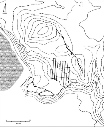
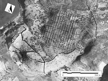
The presence of this planned city at Krane, in the area partly enclosed by the Hellenistic enceinte, was first reported by Klavs Randsborg, who published a plan of it (Fig. 3). Noting the almost total absence of surface finds, Randsborg (Reference Randsborg2002, vol. 2, 297–307) concluded that the settlement was never completed. Previously, mapping had been made difficult, if not impossible, by the presence of dense vegetation in the entire area.
The map of Nea Krane published by Klavs Randsborg (Reference Randsborg2002, vol. 2, 302, fig. X:8).

Significant emigration from the islands in the aftermath of the 1953 earthquakes resulted in the abandonment of fields and pastures. The sudden end to ploughing and grazing resulted in the rapid and uncontrolled afforestation of many areas, the shores of the Koutavos lagoon among them. In subsequent decades, the progressive shift from an economy based on husbandry and agriculture to one based on tourism and services further enhanced this phenomenon. In fact, the Danish team was able to study the site only after a fire had destroyed the vegetation in the area. This temporary, although partial, absence of coverage, made it possible to observe traces of the orthogonal road system from the surrounding hills. Nevertheless, even in the immediate aftermath of the fire, mapping with a total station was impossible due to quick regrowth of vegetation: the study was therefore undertaken using oblique aerial photographs, of which no details were published (Randsborg Reference Randsborg2002, vol. 1, pl. B:98–9). From 2009 onwards, surveying and mapping were undertaken by the Greek Archaeological Service, resulting in a new site plan which essentially confirmed the Danish findings (Sotiriou Reference Sotiriou2013, 24–7).
Imagery pre-dating the 1953 earthquake and the ensuing afforestation therefore seems a particularly promising source to investigate for additional traces of the settlement. Aerial imagery has been widely used in the last 60 years to reconstruct schemes of urban and rural planning in the Greek world, especially in the Greek colonies in Italy and Sicily where a significant amount of photographic material is available (Guaitoli Reference Guaitoli2003, 357–9, with bibliography). Recently, the remarkable potential of modern remote sensing techniques has been demonstrated, yielding excellent results. Of particular relevance to southern Kephallonia, a study of multi-spectral satellite imagery aimed at the detection and mapping of near-surface remains of orthogonal roads has revealed extensive traces of the urban planning of Mantinea and Elis, potentially dating back to the fourth century in the former case and the fifth century in the latter (Donati and Sarris Reference Donati and Sarris2016). Be it with aerial or satellite imagery, the study of urban and rural planning remains an ideal field for the application of remote sensing techniques due to the particular geometric relationship between different features (aligned, perpendicular or parallel). This peculiarity allows relevant features to be isolated easily, either manually or using specific digital algorithms.
GATHERING DATA
Relevant photographic material has been sought in the archives of the British School at Athens, at the aerial photography department of the Geographic Service of the Hellenic Army, and in the photographic archive of the Greek Cadastral agency, all of which hold material pre-dating 1953.Footnote 3 The coverage available from the Geographic Service of the Hellenic Army was made in preparation for the drawing of the 1:50,000 maps of Greece, with a scale of approximately 1:45,000. The material held by the Greek Cadastral agency was mainly connected to the planning of public works: it is therefore largely confined to urban areas and uses a scale unsuitable for archaeological photo-interpretation. The archive of the British School at Athens holds images from multiple flights covering the area of Krane made by Allied photo reconnaissance missions during World War Two.
Even though the Allied aerial imagery was not originally intended for archaeological interpretation, it has yielded excellent results in a number of cases, including the orthogonal plan of Metapontum (Adamesteanu Reference Adamesteanu1965; Bradford Reference Bradford1957, 225; De Siena Reference De Siena2003, 363, fig. 650). In that case, the fact that the ancient city was very close to an area of high strategic importance (the military airfields of Apulia) meant that a vast RAF photographic coverage was made, with a scale suitable for archaeological interpretation and mapping. A similar coincidence between an archaeological site and a strategic location is evident at Krane, where the ancient city lay close to Argostoli, with its harbour, airfield, and German garrison. Twelve flights were retrieved (BSA, Aerial Photographs Collection, flights P1–P12), made between September 1943 and September 1944, and with scales between 1:10,000 and 1:52,000. These form the core of the analysis in this study.
PRE-PROCESSING
The British School at Athens does not hold the negatives of the Allied photographs in its collection. Analysis is therefore limited to study of the prints, entailing a potential loss of data and limiting the possibility of digital enlargement of the images. In dealing with this material, special care has been taken to avoid losing further quality both in the scanning and in the digital management of the files. The first step was the double scanning of the positive photographic prints at a resolution of 600 and 1200 dpi.Footnote 4 Each frame was scanned along with a ruler for the subsequent scaling of the images. A digital white balance of the images was then carried out, using as the colour reference for white the writing on the frisket.Footnote 5 Given that the orientation of a print is connected to the direction of the flight and the position of the camera, at this stage every image was rotated to place magnetic north at the top.Footnote 6 Since the greater the focal length, the greater the optic distortion on the edges of the image, the central c. 40 per cent of each image was cropped and exported to a separate file. Before cropping, the image of the ruler scanned along with the print was substituted for a vectorial one, and a bar matching the scale of the photo added.
PRELIMINARY READING
The reading of the frames was achieved via double stereoscopic analysis: two stereoscopes with a respective magnification power of 2x and 4x were used over each pair of images with a forward overlap of at least 70 per cent. The choice of foldable stereoscopes was deliberate, due to the peculiar accentuation of elevations that they provide, and thus their considerably higher potential to detect micro-relief (Piccarreta Reference Piccarreta1987, 137–8). The importance of their capacity to detect micro-elevations on the ground is confirmed by the information gathered about the surface remains. Randsborg's published description of the site suggested the presence of exposed remains: ‘on the ground, this huge “ghost-city” appears as ribbons of flattened rock and a few rows of blocks etc. across earthen surfaces, both delineating the streets, 12+ parallel ones going north–south and at least four, also parallel, going east–west’ (Randsborg Reference Randsborg2002, vol. 2, 299). For a significant number of features, it was possible to observe some kind of micro-elevation during the stereoscopic reading.
In the material identified, the area has a modest coverage of vegetation, mainly grass and bushes with only few trees. Terraces were immediately recognisable in the north-west of the area of the ancient city, along with signs of land divisions in the entire area. A large number of anomalies in the land cover have been observed, belonging to three categories (Fig. 4):
1. Micro-elevations (with or without shadow);Footnote 7
2. Negative crop marks (anomalies of the vegetation resulting in clearer areas);
3. Positive crop marks (anomalies of the vegetation resulting in darker areas).
Cumulative drawing of the anomalies observed via stereoscopic interpretation of the positive prints.

The features noted during the stereoscopic analysis have been transcribed on the digital copy of each image.
PROCESSING AND COMPARATIVE READING
Each frame (or stereoscopic pair of frames) displayed a certain number of features which required comparative study to achieve a global reading. The traces transcribed from each photograph and each flight were all subsequently scaled to 1:12,500, the scale of flight P6.Footnote 8 Frame P6 4047 was used as the basis for the subsequent drawing of features, since it had the best coverage of the area of interest for this study.
Given that in this case the nature of the site was known, and an orthogonal plan had already been described, the next step was to isolate features with a north–south and east–west orientation.Footnote 9 Fig. 5 gives a global overview of all such features, which align over 16 axes north–south and six east–west.
Synthesis of the marks connected to the orthogonal planning of Nea Krane observed in the stereoscopic analysis of the photographs.

DESCRIBING THE ANOMALIES
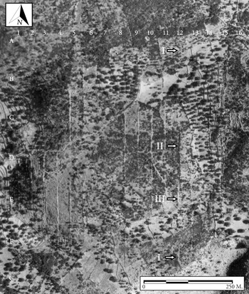
At this point, a few words must be said about the character of these features and what emerges from their comparative reading. It has already been noted that the features belong to three categories: micro elevations, negative crop marks, and positive crop marks. Clearly, an elevation, even if minimal and observable only through stereoscopic manipulation of three-dimensionality, is connected to the presence of something above ground level. Conversely, crop marks are generated by the interference of something present underground with the growth of the vegetation over it (Piccarreta Reference Piccarreta1987, 115 and 126–34). Unsurprisingly, comparative reading revealed that traces connected to micro elevations over ground were visible in all the photographs with just minor variations.Footnote 10 These features partially align with those observed and mapped by Randsborg (Reference Randsborg2002, vol. 2, 302, fig. X:8). However, the crop marks, whether positive or negative, were displayed differently in each flight. The presence and evidence of these features is directly connected to variable factors such as the moisture of the terrain, rainfall, heat, the kind of crop and the season.Footnote 11 Fig. 6 presents a comparative view of the orthogonal traces observed during the stereoscopic reading of each flight, along with the roads identified and published by Randsborg. The largest number of features appeared in flight P6, taken in late June 1944.Footnote 12
Visibility of the north–south road 12. I: negative crop mark. II: positive crop mark. III: micro elevation. Elaboration of frame BSA P6 4047 (22 June 1944, scale of the original print 1:12,500, reproduced with permission from the British School at Athens).

The crucial importance of a cumulative analysis of the features is exemplified by Fig. 6, which shows how the same north–south road can appear in different sections as a micro-elevation over terrain, as a negative crop mark, or as a positive one. To understand how this can be possible, a brief explanation of the possible dynamics of the formation of such features is needed.
The occurrence of negative crop marks seems to suggest the presence of a road buried at near ground level, thus creating an obstacle to the regular growth of vegetation. Positive crop marks seem to be compatible with at least two scenarios, if we assume them to match the presence of an underground depression filled with humus which allows vegetation to grow stronger and greener (Piccarreta Reference Piccarreta1987, 126–31). The first is that they represent a different state of completion of an abandoned project, when the trenches to lay the foundations of the roads had been dug out. The second scenario is that sections of the roads had been removed to be reused, leaving exposed some kind of ditches. Clearly those possibilities are not mutually exclusive and could easily coexist in different parts of the planned city.
A NEW MAP FOR NEA KRANE
A general study of all the isolated features allows the map of the planned city of Nea Krane to be significantly updated. It gives a better understanding of the scale of this large project of urban planning, which can now be seen to consist of 90 blocks. The map published in 2002 had 12 north–south roadsFootnote 13 and four east–west:Footnote 14 now it is possible to map 16 and seven respectively.Footnote 15 The general plan appears to be different as well, as the map published by Randsborg assumed the existence of rows of blocks of different length, ranging from 133 to 200 m and with a fixed width of 33 m, with ratios ranging from 1:4 to 1:6. The historical aerial photographs display the presence of additional west–east roads, partitioning all the blocks with a regular size of 33 x 100 m, and a ratio of 1:3 (Fig. 7).
Reconstruction of the orthogonal planning of Nea Krane (dashed lines indicate hypothetical restorations).

The area of the planned city which can be reconstructed is almost doubled, rising from 19.8 haFootnote 16 to 36.96 ha, and thus shedding new light on the scale of a majestic project which now counts 90 blocks. The newly mapped planned city occupies more than one-third of the entire area enclosed by the walls (Randsborg Reference Randsborg2002, vol. 2, 56). It is not yet possible to speculate on whether the planned city was meant to be just the central part of the wider space surrounded by the enceinte,Footnote 17 or whether this was simply the part completed at some stage of a wider project aimed at the organisation and division of the entire walled zone (Fig. 8).Footnote 18
The city of Krane and the reconstructed map of Nea Krane. Elaboration of frame BSA P6 4047 (22 June 1944, scale of the original print 1:12,500, reproduced with permission from the British School at Athens). Relief of the walls of Krane after Sotiriou Reference Sotiriou2013, fig. 32.

KRANE AND NEA KRANE: SETTLEMENT DYNAMICS
To understand some of the implications of the new data for the planned city of Nea Krane, it is useful to look at the city in the wider framework of the settlement dynamics of the entire polis of Krane. Mapping undertaken by the Greek Archaeological Service from 2009 onwards has contributed to the identification of the main settlement on the south and western slopes of the acropolis (Sotiriou Reference Sotiriou2013, 24–7). This position puts the town of Krane in direct connection with at least three important foci of economic activity: the Koutavos lagoon, the harbour of the city, to the west; the forest of Mount Ainos to the east; and the large plain to the south. Archaeological evidence points to an economic model based on a plurality of activities undertaken in a wide range of satellite sites around the central town. A number of agricultural and herding communities (attested by their burials) lay across the entire plain around the central city: their tombs were located on rocky hills to preserve arable land for cultivation (Marinatos Reference Marinatos1932, 1–5; Reference Marinatos1933, 68–70; Sotiriou Reference Sotiriou1991; Reference Sotiriou1993; Reference Sotiriou1995). Two pottery kilns, of the sixth and the third centuries bc respectively, have been identified to the south-west of the main settlement (Sotiriou Reference Sotiriou and Antonetti2010, 109, fig. 5; Reference Sotiriou2013, 27–9). Salt extraction and quarrying happened in the area of modern Svoronata in the far south of the island (Sotiriou Reference Sotiriou2013, 29). The forest of fir trees on Mount Ainos, which provided superb raw material for ship building, was divided between the poleis of Krane, Same and Pronnoi (Sotiriou Reference Sotiriou and Antonetti2010, map 3), constituting a further focus of economic activity for our city. At the centre of this wide network of economic activities, the town of Krane was in absolute terms modest in size: a narrow strip of 300 m inside the western and eastern enclosure of the walls. It does not appear to have been a monumental settlement, although its comparatively large size by Kephallonian standards, and its position by a superb harbour and at the centre of this wider network of production, testify to its eminent role as a trading centre.
The project to build a large orthogonally planned city, this time on the north-west of the acropolis, therefore poses different questions about settlement patterns. It is reasonable to suppose that urban planning could have been a local concern given comparable developments elsewhere on Kephallonia. At least two other cities underwent planned redevelopment at various stages from the early fourth to the third century, the dates in both cases being more securely archaeologically corroborated. Same, on the eastern coast, has a Late Classical orthogonal development (c. 375 bc), based on the Ionian foot (37.5 cm), with blocks of 89 x 30 m (ratio 1:3) divided into square plots of 14.8 x 14.8 m (Randsborg Reference Randsborg2002, vol. 2, fig. X:2; maps in vol. 1, pls D:LII–D:LXI). South of Same, in the polis of Pronnoi, traces of orthogonal planning (too slight to propose a model) have been identified in the coastal town of Poros, for which a date of c. 300 bc has been proposed (Randsborg Reference Randsborg2002, vol. 2, 299–301). Yet with a settlement area of almost 40 ha currently attested, in an entire walled area of almost 144 ha, Nea Krane had the potential to be one of the largest walled cities in Greece after Demetrias, depending on how much of the walled area was actually settled. For comparison, Early Hellenistic Leukas, which occupied the entire area within the walls, covered c. 100 ha.
Even if it is safe to infer that a city which was so much larger must have reflected what Andreas Sotiriou (Reference Sotiriou2013, 26) has called ‘an explosion of population’ around 300 bc, it is not clear where such a significant number of people would have come from, and even more interestingly, where they went when the project was left unfinished. Were they the original inhabitants of Krane spontaneously planning to relocate to a wider area? Were people from the satellite settlements of the polis relocating to the projected Nea Krane? If what we are looking at is effectively just a fascinating example of a failed synoikism or plan to extend the residential area, what would have formed the economic base of the new city? What would a mass relocation to a centre have meant for an economy based on the exploitation of a variety of scattered resources? If they were locals, either from the town or the wider city territory, it is difficult to understand why in later periods no one ever went to inhabit what had become a monumental ‘ghost city’, especially after the great investment required by the construction of a new enclosure and the orthogonal roads. Nevertheless, that is what the archaeological evidence at the moment suggests, with no pottery found in the planned city, inside the fortification enclosure, or at the Dipylon Gate (Sotiriou Reference Sotiriou2013, 25–7 n. 64 in particular). The aerial photographs too revealed no remains of structures in the area of Nea Krane apart from the roads.
The abandonment of the project of Nea Krane had no obvious impact on the city of Krane. Settlement continued into the Hellenistic and Roman periods both in the central town and in some of the satellite settlements, with a stoa built on the acropolis (Kalligas Reference Kalligas1969), a pottery workshop producing amphorae in the Koutavos valley (Sotiriou Reference Sotiriou2013, 27–9), and a necropolis in the southern valley at Mazarakata (Sotiriou Reference Sotiriou1993, 148). It therefore seems that settlement dynamics continued in broadly the same way after the abandonment of the project of Nea Krane, with a number of smaller production sites around a central settlement connected to the sea. The question at this point is whether these patterns had changed at all, if the local population had reverted to a dynamic of scattered settlements around a trading centre, or if this dynamic had never been abandoned. The substantial continuity of certain communities, such as that at Mazarakata, seems to point to the absence of any significant break, making it likely that that the economic model based on the exploitation of a variety of resources across the south of the island effectively continued not only unchanged but able to sustain those communities. Noting other instances of large-scale synoikism and urban relocation – Megalopolis being a striking example (Roy Reference Roy and Østby2005) – it is rarely the case that there is an immediate abandonment or visible alteration in rural settlement, whatever contemporary rhetoric may suggest. One would not, therefore, automatically expect such a change in the case of Krane. However, the unusually large scale of Nea Krane would surely have made exceptional demands on population and resources: it is instructive to note that the entire area of the old city of Krane, as mapped by the Greek Archaeological Service, would fit into less than 10 blocks of Nea Krane. So, if the abandonment of the building project (whether by a single strategic decision or continuing failure to resume operations) is to be read in this wider framework, it seems logical to assume that the fact that the new city remained uninhabited indicates that it was unsuited to the settlement needs of the local communities alone. If this new colossal city did not fit the needs of the locals, the possibility that we are looking at a failed purely local plan for synoikism can be excluded, making external intervention more plausible.
Randsborg reached the same conclusion but on different grounds, arguing that because the project looks too big to have been undertaken by a single city, it must reflect external intervention. The fact that data from aerial photographs double the size of the planned settlement adds weight to this argument. What would be the attraction for an external investor? Proximity to the harbour at Koutavos must have been a major factor, since this is one of the finest natural locations to base a fleet in the Mediterranean (Randsborg Reference Randsborg2002, vol. 2, 51), especially given the availability of timber from the pine forests of Mount Ainos. The harbour was easily defensible, with fine plain land behind it to support its population. The likelihood that the planning of Nea Krane should be linked to wider strategic, geopolitical concerns must therefore be considered.
As Randsborg indicates, the strategic location of Kephallonia in the context of the politics of the New Corinthian League (of which the central Ionian islands were part) makes investment in the defensive and urban infrastructure of the island perfectly plausible. While he does not address the question of why Krane should have been chosen, we may suggest that the harbour was a key factor. Randsborg, however, moved directly from questions of immediate strategic and political environment to propose that Demetrios I Poliorketes played a direct role in the planning of this new city, although it is never mentioned in historical sources (Randsborg Reference Randsborg2002, vol. 2, 32 and 304–7). On this argument, the project was abandoned because Demetrios moved on. This particular case is highly circumstantial and can be criticised on methodological grounds since it implies a desire to associate constructions with historical personalities and/or events. Randsborg may be correct, but there is no need to press the case to this extent.
PARALLELS FOR A GHOST CITY: NEA KRANE AND GREEK URBAN PLANNING
Randsborg's proposed Early Hellenistic date for Nea Krane appeared to be supported by the elongated shape of the city blocks (where he identified a ratio ranging from 1:4 to 1:6). In this respect, Nea Krane conforms to the Early Hellenistic fortress city in the typology of Hoepfner and Boessneck, which they considered being probably modelled on military camps (Hoepfner et al. Reference Hoepfner, Boessneck, Dakaris and Schwandner1994). Randsborg's plan, however, shows residential blocks of different lengths in different rows, a feature which does not conform to the Early Hellenistic fortress model, nor indeed to the cases which he cites as parallels (see below). Randsborg's proposition can now be re-examined by comparing the extended and revised map of Nea Krane realised with aerial photographs with those of other Greek planned cities, including interesting new data from prospections and remote sensing in the central and western Peloponnese, noting especially Mantineia and Elis (Donati and Sarris Reference Donati and Sarris2016).
The new information available for Nea Krane, and in particular the new east–west roads creating residential blocks of 100 x 33 m, calls into question the claim that the city conforms to this particular Early Hellenistic model simply because of the elongated shape of the blocks. The claim can also be criticised on methodological grounds, since recent data from the Peloponnese show how varied the shape of blocks can be, with the same ratio recurring in completely different periods (Donati and Sarris Reference Donati and Sarris2016, 394). In fact, if we follow Randsborg in using a block shape, and in particular the ratio between width and length, as a criterion, then the ‘fine general parallel’ identified by the author (Randsborg Reference Randsborg2002, vol. 2, 299) between Nea Krane (ratio 1:3) and Halos (ratio 1:6)Footnote 19 (from 302 bc) can no longer stand. The general similarities proposed with Goritsa (ratio 1:5)Footnote 20 and Demetrias (ratio 1:2)Footnote 21 do not fit the new data either. Interestingly, if we pursue Randsborg's methodology using the newly established ratio of 1:3 for Nea Krane, the closest parallel appears to be the Kephallonian polis of Same (also 1:3), the replanning of which is dated by Randsborg to the Late Classical period (with secure archaeological corroboration). Elsewhere, looking just at the Peloponnese, there is a parallel in Stymphalos in Arcadia, with its system of blocks of 100 x 30 m, dated to the mid-fourth century (Donati and Sarris Reference Donati and Sarris2016, 393). Even Tegea (75 x 25 m), the planning of which is at present dated in the sixth century, looks like a suitable candidate (Ødegård Reference Ødegård and Østby2005). All in all, the geometric relationship between the sides of residential blocks is insufficient evidence to assign a planned city to a certain type.
It is, however, interesting to compare the new map of Nea Krane with data recently obtained for Hellenistic Sikyon. Geophysical prospection, surface survey, and excavation by the University of Thessaly have revealed the orthogonal planning of a city founded by Demetrios I Poliorketes following his destruction in 303 of the previous settlement in a lower valley. Investigations have brought to light a system based on square blocks with sides of approximately 60 m (Lolos, Gourley and Stewart Reference Lolos, Gourley and Stewart2007; Lolos and Gourley Reference Lolos and Gourley2011). Notwithstanding this difference, we can recognise in Sikyon the fundamental traits of Nea Krane, notably a grid strictly following the cardinal points and not the geomorphology of the territory (an approach typical of the Hellenistic period), along with an extreme regularity and a tendency to create square blocks or plots. All of these elements, typical of Hellenistic urban planning (Greco & Torelli Reference Greco and Torelli1983, 317–94, quoted in Donati and Sarris Reference Donati and Sarris2016, 393), can be found in Nea Krane. The rigid orientation along the cardinal points has already been explained, along with the regular creation of blocks of 33 x 100 m in the entire planned city as mapped from the aerial photographs. The square plots have been identified by Randsborg (Reference Randsborg2002, vol. 2, 299), with minor traces of the divisions separating each block into 12 plots measuring 16.5 m on each side. The presence of all these elements together provides a much more reliable basis for a date in the Early Hellenistic period than reliance upon the shape of city blocks, as it fits trends widely recognisable across Greece. An example of this trend can be seen for example at Demetrias (Hoepfner et al. Reference Hoepfner, Boessneck, Dakaris and Schwandner1994, 326), with its roads with rigid north–south and east–west orientation and square plots with 25 m sides (eight plots per block).
KRANE AND THE OTHER PLANNED CITIES IN THE CENTRAL IONIAN ISLANDS
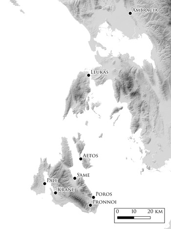
Nea Krane was not the only planned city in the central Ionian islands (Fig. 9). Further examples of orthogonal planning are found at the colonial city of Leukas and in other poleis on Kephallonia (at Same and at modern Poros, the port of Pronnoi). Leukas, a Kypselid foundation of c. 630 bc, may be treated briefly as it belongs within an earlier tradition of Corinthian colonial planning. As many rescue excavations have confirmed (Andreou Reference Andreou1998), the city plan featured insulae measuring 120 x 30 m, internally divided to form two rows of eight equally sized (15 x 15 m) plots. Preserved building phases date from the Archaic to the Hellenistic period (Fiedler Reference Fiedler2013). The city plan is similar to that found in other contemporary Corinthian colonies, including Ambracia and the second wave of foundations on Sicily (Andreou Reference Andreou1998, 147, 155).
Central Ionian Islands, with mentioned locations. ASTER GDEM is a product of METI and NASA.

Moving to Kephallonia, the Late Classical plan of Same (c. 375 bc) was orthogonal, with blocks of 89 x 30 m (ratio 1:3) divided into square plots of 14.8 x 14.8 m (Randsborg Reference Randsborg2002, vol. 2, fig. X:2; maps in vol. 1, pls D:LII–D:LXI). Traces of orthogonal planning have also been identified in the coastal town of Poros, with a proposed date of c. 300 bc, but they are too slight to propose a model (Randsborg Reference Randsborg2002, vol. 2, 299–301). While Klavs Randsborg does not exclude the possibility that further Early Hellenistic planned cities may have existed (or at least been projected) on the Palaikastro acropolis of Pronnoi and at Aetos on Ithaki, no traces of orthogonal planning have yet been identified on either site. The fourth city of the Kephallonian tetrapolis, Pale, is extremely poorly preserved, not least because its remains were used in the construction of modern Lixouri (Sotiriou Reference Sotiriou and Antonetti2010, 100).
The Kephallonian tetrapolis is an interesting example of four non-colonial cities on a single island. Three of these four poleis preserve traces of orthogonal urban planning. The earliest, Late Classical Same, is a large centralised walled settlement connected to a port and thus to the activities of a merchant fleet: while there are farmhouses in the chora outside the walls (Sotiriou Reference Sotiriou and Antonetti2010, 99), a substantial share of the population evidently lived in the city centre. The laying out of the planned city does not appear to have been a disruptive event, but was rather an extension of previous settlement growth which allowed for the continued exploitation of its harbour. The case of Poros is of particular interest given the closeness of its proposed date to that of Nea Krane. The town functioned as Pronnoi's main outlet to the sea,Footnote 22 and (like Nea Krane) is close to the slopes of Mount Ainos and its fir forests, which seem to have been the city's main economic resource.
In short, the Early Hellenistic period saw the development of two planned cities, both connected to the exploitation of the Kephallonian fir for shipbuilding. Investment in the defensive and urban infrastructure of the poleis of Krane and Pronnoi fits in the context of the politics of the New Corinthian League (of which the central Ionian islands were part). Nea Krane and the planned city at Poros show how the islands, and Kephallonia in particular, engaged with Early Hellenistic trends in urban development, as seen also at Halos, Goritsa and Demetrias.
ACKNOWLEDGEMENTS
The author expresses his thanks to Prof. Catherine Morgan for constant research guidance, and to Andreas Sotiriou (Ephorate for Underwater Archaeology) for useful input and for having shared generously information on his work in the site of Krane. This research has been possible thanks to generous access to BSA collections, and in particular to the Aerial Photographs Collection, for which thanks are due to Library staff. Generous support is acknowledged from Merton College, the Arts and Humanities Research Council, and a number of Oxford institutions: Humanities Division, Faculty of Classics (Craven Committee), and School of Archaeology (Meyerstein Fund).