Introduction
Policies, economic, and societal demands are driving an increase in the conversion of natural landscapes to human-dominated lands (Wilson et al. Reference Wilson, Chen, Corlett, Didham, Ding, Holt, Holyoak, Hu, Hughes, Jiang, Laurance, Liu, Pimm, Robinson, Russo, Si, Wilcove, Wu and Yu2016). In particular, habitat loss and fragmentation in tropical countries have led to the greatest loss of global biodiversity in natural history (Barlow et al. Reference Barlow, Lennox, Ferreira, Berenguer, Lees, Mac Nally, Thomson, Ferraz, Louzada, Oliveira, Parry, Solar, Vieira, Aragao, Begotti, Braga, Cardoso, De Oliveira, Souza, Moura, Nunes, Siqueira, Pardini, Silveira, Vaz-De-Mello, Veiga, Venturieri and Gardner2016; Newmark et al. Reference Newmark, Jenkins, Pimm, Mcneally and Halley2017). As habitat loss and fragmentation have increased dramatically, protected areas have increasingly become important refuges for sustaining biodiversity (Crooks et al. Reference Crooks, Burdett, Theobald, King, Di Marco, Rondinini and Boitani2017). Nevertheless, many protected areas in tropical countries are vulnerable to anthropogenic activities and environmental change (Bruner et al. Reference Bruner, Gullison, Rice and Da Fonseca2001; Sims Reference Sims2014). It is not clear that tropical protected areas are adequate safeguards for remaining forest habitats and facilitating species range expansions against those threats (Schleicher et al. Reference Schleicher, Peres and Leader-Williams2019). Empirical studies suggest that sufficient extent and connectivity of protected areas are vital to maintain existing species and reduce the rate of species extinctions (Pimm & Jenkins Reference Pimm and Jenkins2019). However, practical difficulties for species conservation and management in several tropical protected areas still exist due to the lack of statistical comparisons on fragmentation patterns for pre- and post-establishment, and inside and outside protected areas that can be effectively applied to sustain threatened species and maintain ecological functioning in forest ecosystems (Rodrigues and Cazalis Reference Rodrigues and Cazalis2020).
Thailand is a global biodiversity hotspot (Pimm et al. Reference Pimm, Jenkins, Abell, Brooks, Gittleman, Joppa, Raven, Roberts and Sexton2014), and is experiencing rapid economic development, with the highest rates of deforestation within the Indo-Burmese region (Zhang & Su Reference Zhang and Su2020). Most threatened species are extirpated from non-protected forests, whereas threatened species only exist within protected areas (Tantipisanuh & Gale Reference Tantipisanuh and Gale2013). In light of this, the effectiveness of protected areas is crucial to sustain the biodiversity in Thailand. Yet these protected forest ecosystems and their surroundings are threatened due to legal and illegal logging, agricultural conversion, and other types of land-use change (Trisurat Reference Trisurat2018). This trend is expected to continue and has caused large-scale deforestation and significant losses of biodiversity in Thailand (Trisurat et al. Reference Trisurat, Kanchanasaka and Kreft2014). Therefore, identification of habitat fragmentation on protected areas and protection of sufficient forest habitats is urgent. However, monitoring fragmentation patterns for pre- and post-establishment of protected areas is limited. In order to understand biodiversity loss and provide effective strategies for policymaking, ones also need to assess habitat change and evaluate the capacity of existing protected areas in protecting wildlife habitat (Bowker et al. Reference Bowker, De Vos, Ament and Cumming2017).
The protected area system in Thailand covers 96,042 km2 or ∼ 18.5% of the country’s area, which includes 108 national parks, 57 wildlife sanctuaries, 113 forest parks, 51 non-hunting areas, 16 botanical gardens, and 55 arboreta, two main categories of the protected area, national protected areas and wildlife sanctuaries, forbid all extractive use. Despite these efforts, many species in Thailand have already been extirpated and others reduced to low abundance (Pattanavibool & Dearden Reference Pattanavibool and Dearden2002; Trisurat et al. Reference Trisurat, Kanchanasaka and Kreft2014). Thailand banned all commercial logging in natural forests in 1989 and this has been effective as far as illegal logging is concerned. However, deforestation and forest degradation have continued because of the demand for land for agriculture and development (Hurni and Fox Reference Hurni and Fox2018). Most of the deforestation is on forested area outside protected areas. This leads isolation of forest habitats among those natural forests more than those within protected area network (Trisurat Reference Trisurat2018).
The Royal Forest Department in Thailand estimated that more than 12 million people inhabited national reserve forests in 1990, with a significant number of them in protected areas (Phromma et al. Reference Phromma, Pagdee, Popradit, Ishida and Uttaranakorn2019). Land speculation due to commercial tourism in the last decades has also contributed to forest encroachment. Settlements within protected areas often contribute to forest loss and degradation as well as extensive hunting activities. Encroachment at the perimeter reduces the effective size of protected areas. Fires affect forest configuration, and lower the carrying capacity for many mammal species. Roads allow greater human access for illegal activities in the protected area, contributing to wildlife mortality and causing habitat fragmentation (Andam et al. Reference Andam, Ferraro, Sims, Healy and Holland2010; Pattanavibool & Dearden Reference Pattanavibool and Dearden2002; Trisurat et al. Reference Trisurat, Alkemade and Verburg2010).
Despite establishing extensive protected area networks and the national logging ban, Thai’s Government has launched big development projects such as timber extraction, large-scale plantation and intensive commercial agriculture (Talerngsri-Teerasuwannajak Reference Talerngsri-Teerasuwannajak2020). These conflicts between economic development and conservation polices are important issues for sustaining biodiversity in many tropical countries (Watson et al. Reference Watson, Dudley, Segan and Hockings2014). Due to ongoing human population growth and the rapid expansion of oil palm and rubber plantations in Thailand, deforestation is expected to continue with increasing habitat loss and fragmentation and infrastructure development (Tantipisanuh & Gale Reference Tantipisanuh and Gale2013).
The goal was to assess the effectiveness of the protected area by analyzing the spatial pattern of the great hornbill habitat before and after Om Koi Wildlife Sanctuary was established and comparing inside and outside habitat conditions of the protected area. My objectives for this study were (1) to quantify spatial patterns of the great hornbill habitat pre- and post-establishment, inside and outside of Om Koi Wildlife Sanctuary; (2) to statistically compare spatial patterns of the great hornbill habitat change over three different time periods during 1973 to 1992.
Methods
Study area
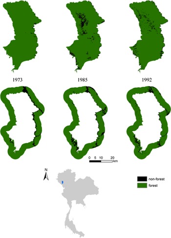
Om Koi Wildlife Sanctuary (Figure 1) covers 1,224 km2 with an elevation between 200 and 1929 meters. The major forest types are evergreen forest, mixed deciduous forest, and dry dipterocarp forest. Om Koi Wildlife Sanctuary was established in 1978 to protect threatened species and intact evergreen forests. This protected area possesses one of the most important evergreen forest communities in Thailand (Pattanavibool & Dearden Reference Pattanavibool and Dearden2002). Nevertheless, traditional agricultural activities, illegal logging, encroachments, and human developments have resulted in fragmented and degraded forests in this area, and many species have become extinct as a consequence. Om Koi is also home to many threatened species, including the great hornbill (Buceros bicornis), one of the large frugivorous birds that still exist in this protected area, though in very low abundance (Pattanavibool & Dearden Reference Pattanavibool and Dearden2002). The great hornbill, therefore, was chosen as a focal taxon in the study for many reasons. First, it is a vulnerable species experiencing populations decline due to habitat loss and fragmentation, and illegal poaching for food, medical purposes, and trade (Bachan et al. Reference Bachan, Kannan, Muraleedharan and Kumar2011). Second, this species requires a large patch of primary evergreen forest for foraging fruit in the tree canopy and nesting in large tree cavities. Reciprocally, this species plays an important role as a seed disperser and could serve as an indicator of forest health. Third, its habitat is exclusively located within and around protected areas in Thailand which are facing high rates of deforestation and habitat fragmentation which serves the primary goal of assessing forest habitat fragmentation and the effectiveness of the protected area in preserving forest habitat. Forth, this species is well studied in Thailand, so its ecology and home range are well understood.
Forest habitat distribution pattern of Om Koi Wildlife Sanctuary and its buffers in 1973, 1985, and 1992, respectively.

Data
I quantified the great hornbill suitable habitat, before and after the protected area was established and surrounding areas, using remotely sensed data on forest cover obtained from LANDSAT Multispectral Scanner System and LANDSAT Thematic Mapper imagery in 1973, 1985, and 1992. The classification of forest cover maps was simple and consisted of only forest and non-forest categories. Forest cover maps were geo-referenced. I defined the great hornbill habitat as intact evergreen forest with minimum patch size of 14.7 km2 using a previous study on the home range of the great hornbill during non-breeding season as determined by a telemetry study in Khao Yai National Park, Thailand. Although it is a different protected area, both protected areas have similar seasonal evergreen forest habitat and climate (Poonswad and Tsuji Reference Poonswad and Tsuji1994). The outside of the protected area is defined as a buffer surrounding the protected area with 6 km-belt. This buffer has a very similar size with the protected area and includes the minimum home range patch of the great hornbill (Figure 1).
Spatial pattern analysis
The FRAGSTATS spatial pattern analysis program version 3 was used to quantify spatial patterns of the great hornbill habitat (McGarigal et al. Reference McGarigal, Cushman, Neel and Ene2002). Eight class-level metrics selected for measures of Great hornbill habitat fragmentation were: (1) proportion of the landscape measures the percentage of forest habitat for Great hornbill in the study area. It is important to measure the proportion of forest habitat that exists within the landscape in the study of forest fragmentation; (2) patch density for forest habitat serves as a good fragmentation index because patch density of forest could determine the number of subpopulations or metapopulation for the great hornbill; (3) edge density indicates habitat fragmentation as an increase in habitat edge and is useful for comparison between landscapes; (4) mean patch size is also a key component of forest fragmentation. This metric is important for great hornbills that require a minimum size of habitat patch; (5) area-weighted mean patch size is used as an indicator of habitat fragmentation and may be more appropriate in cases where larger patches play a dominant role in the landscape; (6) largest patch index quantifies the percentage of landscape dominance by largest patches. It indicates fragmentation and is important to identify habitat use for great hornbills; (7) mean nearest neighbour distance for patches comprising the forest class defines the average edge-to-edge distance between a forest patch and its nearest neighbour in the landscape. This index is also used as a measure of connectivity or fragmentation; (8) clumpiness index describes a class-specific contagion and provides an effective index of fragmentation of the forest habitat (Cushman et al. Reference Cushman, Mcgariyal and Neel2008; Kupfer Reference Kupfer2012; Li et al. Reference Li, Lu, Cheng and Xiao2001). The forest cover maps of the study area are composed of 60 m2 grain size with 1329 rows and 809 columns. All class-level metrics were calculated by eight-neighbour rule.
Habitat fragmentation comparisons
Statistical comparison of changes in spatial pattern of great hornbill habitats at three different time points was conducted using the QRULE program (Gardner et al. Reference Gardner, Milne, Turnei and O’neill1987). QRULE is a program for scale-dependent analysis of landscape patterns based on neutral models. Neutral models allow a comparison between a spatial stochastic process and a real landscape. Also, a real landscape could be compared to a neutral landscape for significance testing. Moreover, it allows for the assessment of the expected range of variation about landscape pattern indices values which allows for statistical comparison and inferences from quantitative analyses of spatial patterns. I used QRULE to generate ten iterations of multifractal random maps of 128 rows and columns with spatial resolution 60 m. Three simulated landscapes were generated with forested percentage of 0.98, 0.93, and 0.95, for forest cover inside the protected area in 1973, 1985, and 1992, respectively. I chose the next-nearest-neighbour rule for analysis because this rule was comparable to eight-neighbour rule from the FRAGSTATS program and the great hornbill movement. Multifractal maps with autocorrelation parameter of 0.9 (H=0.9) were the most realistic landscapes generated by QRULE in this study because the effects of autocorrelation among sites affect the spatial patterns produced by the process of landscape fragmentation. Therefore, high H parameter well represents highly clump of forest habitat within landscapes in this study (Gardner et al. Reference Gardner, Milne, Turnei and O’neill1987; Gardner & Urban Reference Gardner and Urban2007).
I constructed confidence intervals of landscape pattern indices and compared them with a significance test using the total edge of all clusters and the total number of clusters, landscape metrics from the QRULE to patch density and edge density, and class-level metrics from FRAGSTATS.
Results
Habitat fragmentation pattern for the great hornbill
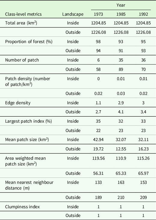
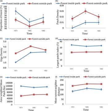
Great hornbill forest habitats in the Om Koi Wildlife Sanctuary became more fragmented after the protected area was established in 1978 based on increases in the patch density, edge density, isolation of forest patches, decreases in proportion of forest cover, mean patch size, area-weighted mean patch size and largest patch index (Table 1). However, forest habitats within the protected area were still well connected with large patches and were suitable for the great hornbill because mean patch size, and area-weighted mean patch size were greater than the minimum suitable habitat patch size of the great hornbill (14.7 km2). Also, the high percentage of the largest patch index of forest inside the protected area indicates that the protected area consists of suitable habitat for the great hornbill. Interestingly, after the national logging ban implemented in Thailand in 1989, the proportions of forest inside the protected area continued to slightly increase and the rate of fragmentation decreased (Figure 2).
Results for class-level metrics as measures of habitat fragmentation for great hornbills pre- and post-establishment, and inside and outside Om Koi Wildlife Sanctuary.

Class-level metrics of (a) percentage of forest, (b) forest patch density, (c) forest edge density, (e) the largest patch index, and (f) mean nearest neighbour distance for the great hornbill habitat pre- and post-establishment, inside and outside of Om Koi Wildlife Sanctuary in 1973, 1985, and 1992.

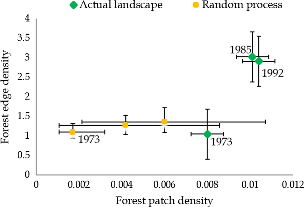
The 95% statistical confidence intervals of three simulated landscapes measure for forest patch density and edge density. The three landscapes are extracted from the proportion of forest inside Om Koi Wildlife Sanctuary in 1973, 1985, and 1992, respectively.

The rates of fragmentation for forest habitat outside the protected area was significantly increased from 1973 to 1985, but the rate of fragmentation was slightly decreased during 1985–1992. The rates of fragmentation outside the protected area were significantly greater than inside the protected area over these time periods (Figure 2). The proportions of forest habitat for the great hornbill outside the protected area were still greater than 90% of the land cover and highly clumped over the time period. As a result, forest habitats outside the protected area could support the great hornbill populations as well.
Habitat fragmentation comparisons
Based on overlapping confidence intervals generated from the empirically simulated maps, forest landscape inside the protected area was not significantly different among the three time points (p > 0.05) regarding patch density and edge density. However, the fragmentation pattern of forest habitat in the year 1973, before the protected area established, was significantly different from the fragmentation patterns after the protected area established (p < 0.05). Therefore, after the protected area established in 1978, the spatial patterns of forest habitat fragmentation inside the Omi Koi Wildlife Sanctuary for the Great hornbill did not differ over the time period (Figure 3).
Discussion
The results suggest that Om Koi Wildlife Sanctuary was not effective in protecting forest habitats for the great hornbill. However, the national logging ban in 1989 may contribute to the slow rates of fragmentation both inside and outside the protected area. Forest habitat fragmentation increasingly occurred inside the protected area after the protected area’s establishment in 1978, even though this area is forbidden from all extractive use. The forest habitat for the great hornbill inside the protected area has been degraded as a result of agricultural activities and illegal logging (Pattanavibool & Dearden Reference Pattanavibool and Dearden2002; Trisurat et al. Reference Trisurat, Shirakawa and Johnston2019). Nevertheless, forest habitat inside the protected area continued to increase and the rates of forest fragmentation were slightly decreased after 1985. These results suggest that an effectiveness of the protected area might be associated with the national logging ban in Thailand. The national logging ban in Thailand has become a practical management to prevent deforestation and allows for forest restoration (Trisurat Reference Trisurat2018; Zeng et al. Reference Zeng, Gower and Wood2018).
The fragmentation patterns in this study are consistent with previous studies of the hornbill abundance in the Om Koi Wildlife Sanctuary (Pattanavibool & Dearden Reference Pattanavibool and Dearden2002; Trisurat et al. Reference Trisurat, Alkemade and Verburg2010). My study showed that mean patch size of forest habitats within and outside of the protected area was greater than a minimum area for the great hornbill home range. Many reasons support my findings. First, after forest clearing in some areas within the protected area in 1973, those fields tended to be abandoned and later a succession caused a various stage of regrowth in the protected area (Pichler et al. Reference Pichler, Bhan and Gingrich2021). The regeneration of forest within the protected area could generate a heterogeneity of landscape and food resources for the great hornbill. Second, the national logging ban in 1989 has reduced the number of large trees which the great hornbill requires for nesting. Reduction of nesting sites can lead to change in nesting composition and reproductive success (James et al. Reference James, Bachan and Kannan2011). Lastly, continuous forest habitat patches within the protected area provide available access to foraging areas for hornbills (Chaisuriyanun et al. Reference Chaisuriyanun, Gale, Madsri and Poonswad2011; Kitamura et al. Reference Kitamura, Yumoto, Poonswad, Chuailua and Plongmai2004).
The rates of loss and fragmentation between inside and outside Om Koi Wildlife Sanctuary were very similar. Forest habitats for the Great hornbill outside the protected area showed significantly fragmented between 1973 and 1985. Previous studies of fragmentation patterns of montane forests outside the protected areas in Northern Thailand demonstrate that before the national logging ban implemented, forest systems outside protected areas were highly degraded due to human activities, such as overexploitation of forests and wildlife, an expansion of agricultural and urban areas (Trisurat et al. Reference Trisurat, Kanchanasaka and Kreft2014). However, the fragmentation rates were slow down since 1985. Several causes probably underlie such a pattern outside Om Koi Wildlife Sanctuary. First, extreme slope and elevation conditions within Om Koi wildlife sanctuary may act as a barrier to forest clearing under severe land-use need for agriculture in northern Thailand (Baicha Reference Baicha2016; Hermhuk et al. Reference Hermhuk, Chaiyes, Thinkampheang, Danrad and Marod2020). Second, there are no paved roads through or near the Om Koi wildlife sanctuary, whereas there are roads running through far south from the protected area boundary that provides access for villages to extract more resources from the forest in that area for the market, cultivate cash crops, illegal logging, and encroachments (Talerngsri-Teerasuwannajak Reference Talerngsri-Teerasuwannajak2020; Trisurat et al. Reference Trisurat, Shirakawa and Johnston2019). Third, the low density of human population around the protected area with very low growth rates may cause slow rates of deforestation, encroachments, and hunting compared to the higher population growth (Trisurat et al. Reference Trisurat, Kanchanasaka and Kreft2014). Forth, sanctuary authorities have been more vigilant in the Om Koi Wildlife Sanctuary in their efforts to control deforestation (Suksawang Reference Suksawang2018). As a result of the interaction among these factors, there are different impacts of human dimensions within the 6- km belt around the protected area in this study and the area that is further south in the previous studies (Pattanavibool & Dearden Reference Pattanavibool and Dearden2002). Therefore, the buffer area in this study could be extended to be able to assess human impacts on forest fragmentation. In addition, including the human population and activities surrounding the Om Koi Wildlife Sanctuary, could explain the slow rates of loss and fragmentation of forest habitat for the great hornbill outside the protected area because socio-economic differences among different areas surrounding Om Koi Wildlife Sanctuary may cause the discrepancy between the rate of habitat loss and fragmentation outside the protected area at different study scales.
Furthermore, differences in forest classification schemes from other studies might contribute significantly to quantitative analyses of forest habitat for the great hornbill in this study. The classification in this study was simple and consisted of only forest and non-forest classifications, while studies of forest fragmentation and the impact on wildlife in northern Thailand classified forest types and land use in 1996 into six types: montane evergreen forest, open and disturbed, montane forest, mixed deciduous forest, dry dipterocarp forest, old clearing, and crop field (Pattanavibool & Dearden Reference Pattanavibool and Dearden2002). Moreover, suitable habitat for great hornbills in this study was intact forest which might be overestimated, because information regarding several factors affecting great hornbill habitat, such as a geo-reference location of the great hornbill, climate variables, food variability, and human disturbance in the study area especially data in the three time periods from 1973 to 1992 were not available. The limitation of data could be problematic for evaluating the fragmentation of great hornbills.
For long-term conservation of great hornbill habitat, information on great hornbill habitat requirements, response to climate change, and human disturbances are needed (Trisurat Reference Trisurat2018; Watson et al. Reference Watson, Dudley, Segan and Hockings2014). In addition, studies on metapopulation in fragmented forests indicate that more connected populations may persist longer. Therefore, increasing connectivity of protected areas by improving habitat quality and landscape context to make it less inhospitable for wildlife dispersal may help improve the effectiveness of protected areas for preserving biodiversity (Pomoim et al. Reference Pomoim, Zomer, Hughes and Corlett2021). Also, reducing impacts of human disturbance, encroachments, and forest degradation need to be enforced for protected areas management strategies (Suksawang Reference Suksawang2018; Trisurat Reference Trisurat2018).
By quantifying the spatial and temporal pattern of tropical forest for great hornbill habitat, I have attempted to show how the great hornbill habitat fragmentation in the protected area and surrounding area is controlled by landscape composition and configuration as well as other drivers that may explain landscape pattern changes such as socioeconomics, abiotic and biotic factors. Also, testing whether landscape pattern indices differ significantly and understanding spatial pattern and ecological process are challenging. Although neutral models, which are one of the approaches for comparison between the outcome of a spatial stochastic process and a real landscape, have provided insight to the comparison of landscape pattern indices or significant testing of differences among landscapes, landscape pattern indices need to be compared with care because composition and configuration influence landscape pattern indices (Gardner & Urban Reference Gardner and Urban2007).
Conclusion
Tropical biodiversity conservation is faced with the challenge of managing wildlife in the context of an intricate web of biotic and abiotic factors and interacting on many scales directly and indirectly. Despite Om Koi wildlife sanctuaries protected status, habitat fragmentation for great hornbills was occurring after the protected area was established because of change in landscapes by human pressures. Therefore, successful protection for biodiversity of ecosystems and species requires increasing support for protected areas to improve effectiveness against all threats. Moreover, quantitative analyses for pre- and post-establishment conditions inside and outside protected areas and integration of other disciplines such as landscape ecology with human demography, and socioeconomics will provide insightful information to develop strategies for long-term biodiversity conservation.
Acknowledgements
I am thankful for funding from Walailak University Research Grant (grant number WU62209). I am grateful to Professor Monica G. Turner and Professor Volker C. Radeloff for insightful suggestions on the early draft. I would like to acknowledge that data for this study were provided by the Tropical Rain Forest Information Center and Dr. Katherine Sims. I thank David Helmers, Shelley Maxted, and Jodi Brandt for their assistance with securing the data. I also thank Patricia Alexandre for helpful suggestions and assistance with FRAGSTATS during data compilation and analysis for this study.