CITY OF LONDON (LONDINIUM)
(1) Crosby Square, 22 Bishopsgate (TQ 33151 81236): an archaeological excavation and watching-brief (YSQ19), started in 2019, continued in 2020.Footnote 95 The initial watching-brief led to the identification of two areas of higher archaeological survival: the UK Power Networks (UKPN) chamber and the Gas Vault (the northernmost of two vaults belonging to the Hiscox building, also called the ‘gas monitoring room’). The earliest recorded stratigraphy consisted of Roman dump layers. These are equivalent to layers recorded at adjacent site CYQ05, where they sealed a high-status Roman building in use in the mid-second to mid-third centuries a.d. The Roman dump layers were sealed by a sequence of archaeological deposits and features, all dated to the eleventh to early fifteenth centuries. The site produced an assemblage of Roman finds comprising pottery, ceramic building material, painted wall plaster and a single Roman coin.
(2) 1–2 Broadgate (TQ 33009 81712): a watching-brief (BDH20)Footnote 96 recovered two human skulls, and two more were recovered subsequently from a shaft dug at the junction of Eldon Street and Broad Street Place. They were recovered from the interface of soft organic alluvium with underlying gravels at a level consistent with being the base of the Walbrook Stream, below the level of the nearby ‘New Churchyard’. They are likely to be eroded from nearby Roman burials.
(3) 35–39 Coleman Street and 62–64 Moorgate (TQ 3268 8142): an evaluationFootnote 97 consisting of eight test-pits uncovered remnants of Roman activity in two of them. In the central part of the site a series of consolidation/ground-raising layers were recorded. A single feature of undetermined function was cut into the upper ground-raising layer. Pottery and CBM recovered from layers and the fill of the cut feature dated to a.d. 55-160. In the eastern part of the site reclamation horizons were truncated by a rubbish pit containing pottery dated a.d. 70–200, which in turn was cut by an east–west linear feature, also of Roman date. Three stake-holes observed along the south edge of the ditch were interpreted as remnants of a revetment/structure. Evidence for Roman glassmaking and other furnace industries was recovered from layers found in two test-pits, in the form of fired clay and brick fragments with molten glass adhering to the surfaces.
(4) 4a and 4b Frederick's Place (TQ 32512 81208): two adjoining basement rooms were excavated (FRP20) ahead of the demolition of the building.Footnote 98 The excavation on both areas was battered at 30 degrees from the base of the existing foundation at 10.40 m AOD along the western edge of site as required by the permanent foundation design. Roman features comprised remains of elements from buildings, largely in the form of brickearth floor layers, possible beam-slot remains and accompanying stake-holes. These survived at a maximum height of 10.74 m AOD, primarily along the western edge of the site, with pronounced slumping towards the eastern edge of the area of excavation. The slumping was due to the presence of an earlier Roman north–south ditch, irregular in its alignment and uneven along its base. The ditch was recorded across the entire excavation area, with evidence of contemporary pitting, as well as earlier pits below in the southern area, probably for quarrying. These features agree with the existing understanding that this area of Londinium would have been at the western edge of the early settlement, at a distance from buildings. Although dating needs to be confirmed, it is likely that the building remains recovered will date to the later first or second centuries a.d., in accordance with the development of the town.
(5) 1 Liverpool Street (TQ 33016 81592): a four-trench evaluationFootnote 99 revealed a stratified sequence from the natural gravels onwards. Second-century Roman activity was observed in two of the excavated trenches. In the central part of the site two small tree stumps provided the earliest evidence of a possible land-clearance episode. To the south of the stumps a substantial north-west to south-east ditch was recorded, sealed by alluvial layers overlain by a succession of ground-raising deposits, which were a likely response to seasonal inundations from the Walbrook. Directly above the ground-raising layers an east–west structure consisting of clay floor slabs and beam-slots was encountered. It was not clear whether these represented alterations to one property or were parts of different structures. The clay floor slabs were truncated by southern edge of an east–west cut, which could have represented a water-management channel or a pool/pond. A series of waterlain deposits recorded in the western part of the site indicated that the area remained marshy ground throughout the Roman period and probably lay within the Walbrook floodplain. Notable finds included a fragment of roller-stamped box-flue tile associated with a clay floor slab, and a bone hair pin. Additionally, an assemblage of pottery dated to the mid-second century a.d. was recovered from the waterlain deposits.
(6) 3 St Helen's Place (TQ 33181 81323): a watching-brief,Footnote 100 within the basement and excavation to the south of 3 St Helen's Place (HNS19), revealed a large early Roman feature that has been provisionally interpreted as either inter-cutting quarry pits or an east–west linear feature. The feature was seen cutting natural terrace gravel at the base of the excavation and was infilled with redeposited brickearth. It was sealed by structural elements relating to Roman clay and timber buildings. These buildings included elements such as an opus signinum layer and plaster-lined walls. The deposit sealing the buildings contained frequent tesserae, possibly suggesting the opus signinum was bedding for a robbed-out mosaic. These were truncated by later robbing cuts and large pits dating to the eleventh to twelfth centuries.
BARNET
(1) Clitterhouse Farm, Brent Cross Town, Cricklewood (TQ 23780 87080): an evaluationFootnote 101 (CIH21) recorded a cluster of Roman features in the eastern part of the site, comprising ditches, post-holes, and gullies apparently of first- to second-century date. These represent limited survival of a possible enclosure associated with agricultural activity. Occupation in the area may have been influenced by the presence of a major Roman road c. 500 m to the south-west of the site (present Edgware Road) as well as the nearby Clitterhouse Stream and River Brent.
HOUNSLOW
(1) Brentford Waterside Development, Block A, St Lawrence's Church and Graveyard, High Street, Brentford (TQ 17451 77275): following two phases of evaluations in 2020 an excavationFootnote 102 (BJB18) was carried out principally to excavate and record the burial ground associated with St Lawrence's church. A roughly north-west–south-east aligned double ditch was recorded cut into the natural in the northern area of the site, containing Roman pottery and ceramic building material. The ditch appeared to terminate at the northern end and measured 48 m to the eastern edge of the site where it met the limit of excavation; the middle portion was heavily truncated by post-medieval structures. A small number of Roman coins were found within post-medieval burial soil to the west of the ditch.
(2) Block D, Brentford Waterside (TQ 17641 77380): a geoarchaeological investigationFootnote 103 (HTE20) indicated that during prehistory the Thames flowed across the lower (southern) slopes of the site, forming a large bend in the river that was subsequently isolated and dried up by the later Roman period. During the early Roman period the northern Thames riverbank was quarried for building material and a series of drainage ditches excavated suggesting possible local farming. Ditches, post- and stake-holes, rubbish pits and possible hearths (fig. 42) yielded a quantity of Roman finds including decorated imported pottery.
A Roman hearth excavated at Block D, Brentford Waterside (Site HTE20). (© MOLA)

SOUTHWARK
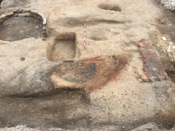
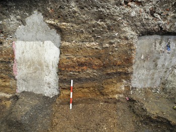
(1) New Hibernia House, Winchester Walk (TQ 32605 80320): an excavationFootnote 104 (WIW19) was carried out in the area of the Outer Court of Winchester Palace, the London residence of the bishops of Winchester from the twelfth century onwards. Although truncated by later work, there was evidence of Roman buildings with masonry walls and multiple floors (fig. 43). Opus spicatum paving bricks suggest there was a herring-bone tiled floor in one area. Previous work has found a prestigious Roman building complex to the north, and it is possible the Roman remains represent one large building with multiple rooms.
Roman stratigraphy excavated at New Hibernia House (Site WIW19). (© MOLA)

TOWER HAMLETS
(1) Iceland Wharf, Iceland Road (TQ 37356 83702): a geotechnical watching-briefFootnote 105 revealed structural timbers within two interventions in the north-eastern part of the site, in proximity to the River Lea. Although it was not possible to determine the dating for either of the timbers, they were tentatively identified as Roman, based on their position in the stratigraphic sequence. The subsequent evaluation discovered evidence of Roman activity on the high gravel terrace at the western end of the site. Roman remains appeared as two large pits (possibly related to quarrying) cut into the natural gravel and backfilled with local waste, interpreted as demolition material from the nearby mansio. A small assemblage of pottery dated to the fourth century was recovered from the pits in addition to building material consisting of brick fragments, tiles, imbrices and combed box-flue tiles.
(2) Imperial 1, Imperial Street (TQ 38252 82634): an open area excavation was undertaken following a 2019 evaluation.Footnote 106 Roman activity was indicated by a curved ditch recorded in the southwest corner of the site and a pit in the central part. The features were dated to a.d. 50–160 and a.d. 43–400 respectively, based on the small assemblages of tile and pottery recovered from their fills.
SUPPLEMENTARY MATERIAL
For supplementary material for this article please visit https://doi.org/10.1017/S0068113X22000447