Investigation of the peopling of the Americas during the last century has been defined by moments of dramatic, punctuated change followed by decades of careful, often localized, scientific investigation. The first such shift occurred in the 1920s with the discovery of unequivocal human artifacts directly associated with the bones of extinct Ice Age bison (Bison antiquus) at the Folsom site in New Mexico (Meltzer Reference Meltzer2006; Meltzer et al. Reference Meltzer, Todd and Holliday2002). With a single, widely accepted archaeological discovery, Native American history was extended into the Pleistocene, shattering the widespread belief that Native Americans arrived in the New World less than 4,000 years ago. Seven decades of research followed that helped define the Clovis-first model, which suggested that Ice Age explorers crossed the Bering Land Bridge sometime in the terminal Pleistocene, passed through an ice-free corridor (IFC) as the Cordilleran and Laurentide ice sheets retreated, rapidly spread across North America beginning around 13,500–13,200 years ago (we report all dates in calibrated years before present), and traveled south into Central and South America shortly thereafter (e.g., Holliday Reference Holliday2000; Meltzer Reference Meltzer1995, Reference Meltzer2009; Suárez and Ardelean Reference Suárez and Ardelean2019; Waters and Stafford Reference Waters and Stafford2007). Upon or shortly after their arrival, they developed the iconic Clovis projectile point that gives the archaeological culture its name. For decades, the Clovis-first model dominated scientific inquiry of terminal Pleistocene archaeology in the Americas, and most archaeologists assumed that occupation of the Pacific Coast occurred after Clovis colonization of the Americas (Dixon Reference Dixon1999; Erlandson Reference Erlandson and Jablonski2002).
Forty years ago, Knut Fladmark (Reference Fladmark1979), in an influential paper cited over 360 times, argued that the Pacific Coast offered an alternative to the ice-free corridor model as the route taken by the first Americans. During a time when Clovis was thought to represent the earliest human presence in North America, Fladmark was among the first (see also Butler Reference Butler1961, Reference Butler1965) to argue effectively for a potential coastal dispersal of peoples into the Americas. The “coastal migration theory” remained on the intellectual margins of Paleoindian archaeology until the late 1990s with the widespread acceptance of the ~14,500 cal BP pre-Clovis occupation at the Monte Verde site in southern Chile, which demonstrated that humans were in South America more than 1,000 years before Clovis (Dillehay et al. Reference Dillehay, Ramírez, Pino, Collins, Rossen and Pino-Navarro2008; Meltzer et al. Reference David J., Grayson, Ardila, Barker, Dincauze, Vance Haynes, Mena, Nunez and Stanford1997). Monte Verde and a handful of other widely accepted pre-Clovis sites (e.g., Gilbert et al. Reference Gilbert, Jenkins, Götherstrom, Naveran, Sanchez, Hofreiter, Thomsen, Binladen, Higham, Yohe, Parr, Scott Cummings and Willerslev2008; Halligan et al. Reference Halligan, Waters, Perrotti, Owens, Feinberg, Bourne, Fenerty, Winsborough, Carlson, Fisher, Stafford and Dunbar2016; Waters et al. Reference Waters, Keene, Forman, Prewitt, Carlson and Wiederhold2018; Waters, Forman et al. Reference Waters, Forman, Jennings, Nordt, Driese, Feinberg, Keene, Halligan, Lindquist, Pierson, Hallmark, Collins and Wiederhold2011; Waters, Stafford et al. Reference Waters, Stafford, Gregory McDonald, Gustafson, Rasmussen, Cappellini, Olsen, Szklarczyk, Jensen, Gilbert and Willerslev2011; Williams et al. Reference William, Collins, Rodrigues, Rink, Velchoff, Keen-Zebert, Gilmer, Frederick, Ayala and Prewitt2018) have reinvigorated the search for the first Americans, as have a series of new genetic studies (e.g., Lindo et al. Reference Lindo, Achilli, Perego, Archer, Valdiosera, Petzelt, Mitchell, Worl, Dixon, Fifield, Rasmussen, Willerslev, Cybulski, Kemp, DeGiorgio and Malhi2017; Llamas et al. Reference Llamas, Fehren-Schmitz, Valverde, Soubrier, Mallick, Rohland, Nordenfelt, Valdiosera, Richards, Rohrlach, Barreto Romero, Flores Espinoza, Tomasto Cagigao, Watson Jiménez, Makowski, Santiago, Reyna, Mansilla Lory, Ballivián Torrez, Rivera, Burger, Constanza Ceruti, Reinhard, Wells, Politis, Santoro, Standen, Smith, Reich, Ho, Cooper and Haak2016; Moreno-Mayar, Potter et al. Reference Moreno-Mayar, Potter, Vinner, Steinrücken, Rasmussen, Terhorst, Kamm, Albrechtsen, Malaspinas, Sikora, Reuther, Irish, Malhi, Orlando, Song, Nielsen, Meltzer and Willerslev2018; Moreno-Mayar, Vinner et al. Reference Moreno-Mayar, Vinner, de Barros Damgaard, de la Fuente, Chan, Spence, Allentoft, Vimala, Racimo, Pinotti, Rasmussen, Margaryan, Iraeta Orbegozo, Mylopotamitaki and Wooller2018; Raghavan et al. Reference Raghavan, Steinrücken, Harris, Schiffels, Rasmussen, DeGiorgio, Albrechtsen, Valdiosera, Ávila-Arcos, Malaspinas, Eriksson, Moltke, Metspalu, Homburger and Wall2015; Scheib et al. Reference Scheib, Li, Desai, Link, Kendall, Dewar, Griffith, Mörseburg, Johnson, Potter, Kerr, Endicott, Lindo, Haber and Xue2018). Most archaeologists now believe the first Americans traversed the IFC or a pacific coast route (PCR), or both, during the terminal Pleistocene, although alternative hypotheses on routes and chronologies persist (e.g., Holen et al. Reference Holen, Deméré, Fisher, Fullagar, Paces, Jefferson, Beeton, Cerutti, Rountrey, Vescera and Holen2017; Stanford and Bradley Reference Stanford and Bradley2012).
Despite decades of research, we still have no definitive answers about when and how the first Americans arrived. Continued interdisciplinary research will be critical to answering such questions and more fully understanding the peopling of the Americas. Compared to decades of intensive research efforts centered on central Alaska and the IFC route, however, the search for terminal Pleistocene occupations along the PCR has been much more limited. Braje and colleagues (Reference Braje, Dillehay, Erlandson, Klein and Rick2017, Reference Braje, Rick, Dillehay, Erlandson and Klein2018) recently highlighted progress made in the last 20 years to better understand human adaptations along the Pacific Coast and called for continued efforts to evaluate the viability of the PCR. Some archaeologists (O'Brien Reference O'Brien2019; Potter, Baichtal et al. Reference Potter, Baichtal, Beaudoin, Fehren-Schmitz, Vance Haynes, Holliday, Holmes, Ives, Kelly, Llamas, Malhi, Miller, Reich, Reuther, Schiffels and Surovell2018; Potter, Beaudoin et al. Reference Potter, Beaudoin, Vance Haynes, Holliday, Holmes, Ives, Kelly, Llamas, Malhi, Miller, Reich, Reuther, Schiffels and Surovell2018) countered that the IFC route remains the most viable and best understood early dispersal route into the Americas.
Here, we review what we have learned about the possibility that humans followed a terminal Pleistocene PCR from Northeast Asia into the Americas. We define the coastal route as largely along shorelines, estuaries, littoral zones, river deltas, and coastal plains, where maritime peoples relied on coastal resources as the central focus of their subsistence economy (Sutton Reference Sutton2018). This definition remains flexible in some physiographic settings, however, including the Pacific Northwest where large rivers with huge runs of anadromous fish may have drawn coastal peoples deep into the interior of the continent. We highlight future research directions and emphasize that the full peopling of the Americas entailed multiple dispersals following different routes at different times.
Coastal Adaptations and Maritime Dispersals in the Old World: What Have We Learned?
In 1979, most archaeologists, anthropologists, and other scholars believed that systematic coastal adaptations, seaworthy boats, and maritime dispersals were very late developments in human history (Erlandson Reference Erlandson2001), limited to the last 10,000–5,000 years or so (e.g., Binford Reference Binford, Binford and Binford1968; Cohen Reference Cohen1977; Greenhill Reference Greenhill1976; Johnstone Reference Johnstone1980; Osborn Reference Osborn and Binford1977:177). In subsequent decades, evidence for a greater antiquity of coastal adaptations, seafaring, and island colonization has increased dramatically (e.g., Bicho et al. Reference Bicho, Haws and Davis2011; Cortés-Sánchez et al. Reference Cortés-Sánchez, Muñiz, Simón-Vallejo, Lozano Francisco, Vera Peláez, Finlayson, Rodríguez-Vidal, Delgado-Huertas, Jiménez-Espejo, Martínez-Ruiz, Martínez-Aguirre, Pascual-Granged, Bergadà-Zapata, Gibaja-Bao, Riquelme-Cantal, López-Sáez, Rodrigo-Gámiz, Sakai, Sugisaki, Finlayson, Fa and Bicho2011; Erlandson Reference Erlandson, Anderson, Barrett and Boyle2010; Marean et al. Reference Marean, Bar-Matthews, Bernatchez, Fisher, Goldberg, Herries, Jacobs, Jerardino, Karkanas, Minichillo, Nilssen, Thompson, Watts and Williams2007; O'Connor et al. Reference O'Connor, Ono and Clarkson2011; Steele and Álvarez-Fernández Reference Steele, Álvarez-Fernández, Bicho, Haws and Davis2011).
When and where systematic seafaring originated remains unknown. There is limited evidence for the crossing of short marine straits by archaic members of our genus (probably Homo erectus), including the colonization of Flores, the Philippines, and other Southeast Asian islands 700,000–1,000,000 years ago (Brown et al. Reference Brown, Sutikna, Morwood, Soejono, Jatmiko and Due2004; Ingicco et al. Reference Ingicco, van den Bergh, Jago-on, Bahain, Chacón, Amano, Forestier, King, Manalo, Nomade, Pereira, Reyes, Sémah, Shao, Voinchet, Falguères, Albers, Lising, Lyras, Yurnaldi, Rochette, Bautista and de Vos2018; Morwood et al. Reference Morwood, Soejono, Roberts, Sutikna, Turney, Westaway, Rink, Zhao, van den Bergh, Awe Due, Hobbs, Moore, Bird and Fifield2004). However, the fact that only Homo sapiens appears to have been capable of reaching the islands of Wallacea and greater Australia, possibly as early as 60,000 ± 5,000 years ago (see Clarkson et al. Reference Clarkson, Jacobs, Marwick, Fullagar, Wallis, Smith, Roberts, Hayes, Lowe, Carah, Florin, McNeil, Cox, Arnold, Hua, Huntley, Brand, Manne, Fairbairn, Shulmeister, Lyle, Salinas, Page, Connell, Park, Norman, Murphy and Pardoe2017), suggests that seafaring by archaic hominins was limited in nature, both technologically and geographically. The successful peopling of greater Australia, which involved multiple sea crossings through island Southeast Asia and Wallacea, was part of the now famous “Out of Africa” dispersal of anatomically modern humans (AMH) that took our species to the far reaches of the world (see Erlandson Reference Erlandson2001; O'Connell et al. Reference O'Connell, Allen, Hawkes, Anderson, Barrett and Boyle2010).
After about 50,000 years ago, evidence for seafaring and island colonization around the Pacific Rim increases dramatically, with multiple voyaging episodes that took humans across salt water gaps approaching or surpassing 100 km—through Wallacea to Australia and New Guinea (O'Connell and Allen Reference O'Connell and Allen2012; O'Connor et al. Reference O'Connor, Ono and Clarkson2011), New Ireland and the Solomon Islands (Allen et al. Reference Allen, Gosden, Jones and White1989; Wickler and Spriggs Reference Wickler and Spriggs1988), Okinawa and the other Ryukyu Islands (Fujita et al. Reference Fujita, Yamasaki, Katagiri, Oshiro, Sano, Kurozumi, Sugawara, Kunikita, Matsuzaki, Kano, Okumura, Sone, Fujita, Kobayashi, Naruse, Kondo, Matsu’ura, Suwa and Kaifu2016; Matsu'ura Reference Matsu'ura and Omoto1996; Takamiya et al. Reference Takamiya, Katagiri, Yamasaki and Fujita2019), and to Honshu in Japan (Ikeya Reference Ikeya, Kaifu, Izuho, Goebel, Sato and Ono2015). Most of these Pleistocene voyagers traversed relatively warm tropical or subtropical waters, but they risked significant potential dangers from storms and tsunamis, as well as venturing into unknown waters and lands. The fact that maritime peoples established viable populations in these new lands suggests that their boats were capable of carrying whole families on long-distance voyages.
By approximately 25,000–30,000 years ago, in what is now Japan, Pleistocene voyagers ventured into colder North Pacific waters. Before and during the Last Glacial Maximum (LGM; ~23,000–18,000 years ago), ancestors of the Ainu used boats to reach obsidian outcrops on Kozushima Island roughly 40–50 km offshore (Ikeya Reference Ikeya, Kaifu, Izuho, Goebel, Sato and Ono2015), transporting artifacts made from this volcanic glass back to mainland sites. This places seafaring people in the cooler waters of Japan and the North Pacific during the LGM, suggesting that they were developing the boats and other technological capabilities to continue around the Pacific Rim to Beringia and beyond. Outlining a “kelp highway hypothesis,” Erlandson and colleagues (Reference Erlandson, Graham, Bourque, Corbett, Estes and Steneck2007, Reference Erlandson, Braje, Gill and Graham2015) argued that nearshore kelp forest, estuarine, and other ecosystems of the North Pacific harbored a diverse array of aquatic and terrestrial resources that provided numerous subsistence options and support for maritime peoples who were potentially dispersing around Pacific Rim shorelines in boats, along a route entirely at sea level and without major obstructions once the outer coast of North America's Northwest Coast deglaciated. Scores of species or genera of marine mammals, fish, birds, shellfish, and seaweed have very broad biogeographic distributions around the North Pacific, providing a continuity of similar resources and habitats stretching from the shorelines of Japan to Alta and Baja California. Past marine environments were not fully analogous to modern conditions, however, and varied considerably between the LGM and the Younger Dryas periods (Davis Reference Davis, Bicho, Haws and Davis2011). Terminal Pleistocene Pacific Coastal ecosystems were dynamic, complex, and variable, but there is no reason to believe that the terrestrial and marine resources they harbored would not have been highly attractive for small groups of early maritime peoples.
Opening Corridors and Constricting Timelines
A major question in evaluating the relative likelihood of a terminal Pleistocene maritime coastal versus interior dispersal route relates to when the two pathways became viable for humans (Mandryk et al. Reference Mandryk, Josenhans, Fedje and Mathewes2001). Recent geological and paleoecological reconstructions suggest that the IFC route was open and habitable by at least about 13,000 years ago, when the waters from Lake Agassiz were draining northward and bison were traversing the corridor between Beringia and continental North America (Froese et al. Reference Froese, Young, Norris and Margold2019; Heintzman et al 2016; Murton et al. Reference Murton, Bateman, Dallimore, Teller and Yang2010). Cosmogenic radionuclide (10Be) dating of glacial erratics indicate coalescence of the Cordilleran and Laurentide ice sheets until after ~15,000 cal BP, while OSL dating of sand dunes and Quaternary vertebrates indicate that the corridor began to open between about 14,000 and 15,000 years ago (Froese et al. Reference Froese, Young, Norris and Margold2019; Margold et al. Reference Margold, Gosse, Hidy, Woywitka, Young and Froese2019; Munyikwa et al. Reference Munyikwa, Rittenour and Feathers2017). This chronology, however, leaves little time for human settlement south of the ice sheets at Paisley Caves (~14,000 cal BP; Gilbert et al. Reference Gilbert, Jenkins, Götherstrom, Naveran, Sanchez, Hofreiter, Thomsen, Binladen, Higham, Yohe, Parr, Scott Cummings and Willerslev2008), Page Ladson (~14,500 cal BP; Halligan et al. Reference Halligan, Waters, Perrotti, Owens, Feinberg, Bourne, Fenerty, Winsborough, Carlson, Fisher, Stafford and Dunbar2016) and Monte Verde (~14,500 cal BP; Dillehay et al. Reference Dillehay, Ramírez, Pino, Collins, Rossen and Pino-Navarro2008)—and no time at all for the ~15,000 cal BP occupations at the Friedkin (Jennings and Waters Reference Jennings and Waters2014; Waters et al. Reference Waters, Keene, Forman, Prewitt, Carlson and Wiederhold2018; Waters, Forman et al. Reference Waters, Forman, Jennings, Nordt, Driese, Feinberg, Keene, Halligan, Lindquist, Pierson, Hallmark, Collins and Wiederhold2011), Gault (Williams et al. Reference William, Collins, Rodrigues, Rink, Velchoff, Keen-Zebert, Gilmer, Frederick, Ayala and Prewitt2018), and Huaca Prieta sites (Dillehay et al. Reference Dillehay, Bonavia, Goodbred, Pino, Vásquez and Tham2012). Continued paleoecological work along the IFC will be critical for understanding the timing and viability of the route for human dispersals (see Potter, Baichtal et al. Reference Potter, Baichtal, Beaudoin, Fehren-Schmitz, Vance Haynes, Holliday, Holmes, Ives, Kelly, Llamas, Malhi, Miller, Reich, Reuther, Schiffels and Surovell2018; Potter, Beaudoin et al. Reference Potter, Beaudoin, Vance Haynes, Holliday, Holmes, Ives, Kelly, Llamas, Malhi, Miller, Reich, Reuther, Schiffels and Surovell2018).
Despite relatively intensive searches by archaeologists and geologists, and the existence of slightly older sites in central Alaska, the oldest well-dated site in the heart of the IFC is Charlie Lake Cave, where the earliest evidence for human occupation—including a single fluted point—dates to ~12,400 cal BP (Driver et al. Reference Driver, Handly, Fladmark, Erle Nelson, Sullivan and Preston1996; Fladmark et al. Reference Fladmark, Driver and Alexander1988). Although small numbers of fluted Clovis-like points have long been known from Alaska, recent excavations at stratified sites suggest they date to ~12,400–12,000 cal BP (Buvit et al. Reference Buvit, Rasic, Kuehn and Hedman2018; Goebel et al. Reference Goebel, Smith, DiPietro, Waters, Hockett, Graf, Gal, Slobodin, Speakman, Driese and Rhode2013; Smith and Goebel Reference Smith and Goebel2018). Current archaeological evidence suggests that Clovis people did not follow the IFC from Beringia into the Americas, but that fluted point makers (or technology) moved through the IFC from south to north (Beck and Jones Reference Beck and Jones2010; Goebel et al. Reference Goebel, Smith, DiPietro, Waters, Hockett, Graf, Gal, Slobodin, Speakman, Driese and Rhode2013). Similar conclusions have been drawn from genetic studies of bison clades north and south of the IFC, which show no evidence of gene flow until ~13,400–12,000 cal BP (Heintzman et al. Reference Heintzman, Froese, Ives, Soares, Zazula, Letts, Andrews, Driver, Hall, Hare, Jass, MacKay, Southon, Stiller, Woywitka, Suchard and Shapiro2016). There also is no evidence for Chindadn points or Yubetsu microblade cores (hallmarks of pre–13,000 cal BP deposits in interior Alaska) within the IFC. Despite this, the IFC remains a potential route for the peopling of the Americas. Alternative terrestrial routes, potentially through unglaciated Cordilleran refugia, remain understudied but intriguing (Dawe and Kornfeld Reference Dawe and Kornfeld2017; Freeman Reference Freeman, Kornfeld and Huckell2016; Loehr et al. Reference Loehr, Worley, Grapputo, Carey, Veitch and Coltman2006).
As with the IFC, the viability of the PCR depends on when deglaciation removed dispersal barriers and allowed subsistence resources to flourish. Early syntheses suggested that a continuous ice margin extended to the edge of the continental shelf through much of southern Alaska and British Columbia until relatively late, preventing human movement along the coastal route in time to account for the terminal Pleistocene archaeological record in continental North and South America (Dyke Reference Dyke, Ehlers and Gibbard2004). Recent studies suggest a significantly earlier deglaciation of the outer Northwest Coast. Lesnek and colleagues (Reference Lesnek, Briner, Lindqvist, Baichtal and Heaton2018) suggested that a viable coastal pathway, along with productive marine and terrestrial ecosystems, existed at least 16,000 and perhaps as early as 17,000 years ago on the basis of cosmogenic 10Be dating of boulders and bedrock surfaces coupled with radiocarbon dating of mammals and birds from island caves (see also Darvill et al. Reference Darvill, Menounos, Goehring, Lian and Caffee2018). As portions of the outermost coast are now well below sea level (see Fedje and Josenhans Reference Fedje and Josenhans2000), the 10Be dates may also be minimum estimates for the initial deglaciation of coastal lowlands. This new chronology suggests ample time for human arrival and settlement of all the widely accepted pre-Clovis sites south of the Laurentide and Cordilleran ice sheets.
Much remains to be learned about the glacial history and viability of the IFC and PCR. Continued geological and paleoecological research of these areas during and immediately following the LGM are needed to resolve which routes were open and viable in time to account for the earliest human occupations of the Americas. The most compelling evidence would be the documentation of well-dated, terminal Pleistocene archeological sites along these potential dispersal routes. Currently, however, there are no well-documented and widely accepted archaeological sites along either route that predate ~13,000 cal BP.
The Archaeology of Pleistocene New World Pacific Coastlines
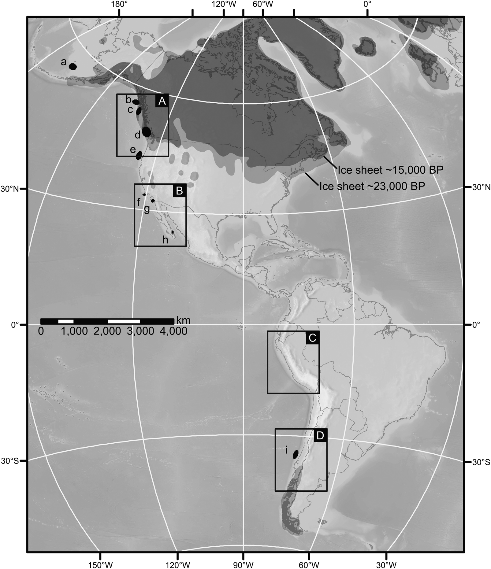
In the last 20 years, archaeologists have accelerated efforts to locate terminal Pleistocene archaeological sites along the Pacific Coast of the Americas (Figure 1). One of the major obstacles is confronting unique site preservation and discovery challenges that likely impacted any record of early coastal settlement. On a continental scale, the rise of post-glacial seas after ~18,000 years ago submerged nearly all the Pacific Coast paleoshorelines that early coastal peoples would have followed moving into the Americas. If a coastal pathway opened ~17,000 years ago and sea levels stabilized about 7,000 years ago, 10,000 years of eustatic sea-level fluctuation resulted in the loss of approximately 10 million km2 of coastal plains from Beringia to southern Chile, with shoreline transgressions of less than 1 km in some steep stretches of the Pacific Coast to ~500 km in parts of Beringia. However, not all terminal Pleistocene shorelines are underwater today (Dixon and Monteleone Reference Dixon, Monteleone, Evans, Flatman and Flemming2014; Fedje et al. Reference Fedje, McLaren, James, Mackie, Smith, Southon and Mackie2018; Potter, Baichtal et al. Reference Potter, Baichtal, Beaudoin, Fehren-Schmitz, Vance Haynes, Holliday, Holmes, Ives, Kelly, Llamas, Malhi, Miller, Reich, Reuther, Schiffels and Surovell2018). Along parts of the Northwest Coast, isostatic rebound (the rise of land masses after the retreat of ice sheets) has raised pre-Clovis shorelines to elevations at or above modern sea level (Mackie et al. Reference Mackie, Fedje and McLaren2018; McLaren et al. Reference McLaren, Fedje, Dyck, Mackie, Gauvreau and Cohen2018; Shugar et al. Reference Shugar, Walker, Lian, Earner, Neudorf, McLaren and Fedje2014). Systematic surveys for early sites along these remote, mostly forested, and difficult-to-access landforms have been productive (see below) but are still in relatively early stages.
Map of North and South America showing the approximate position of glacial ice at 23,000 cal BP and 15,000 cal BP, based on the ICE-6G_C model (Argus et al. Reference Argus, Peltier, Drummond and Moore2014; Peltier et al. Reference Peltier, Argus and Drummond2015). Boxes A, B, C, and D refer to the positions of maps in Figure 2. Locations of underwater projects are marked with lowercase letters: (a) a predictive model for sites on the Bering continental shelf (Dixon Reference Dixon1979); (b) underwater survey in Beringia (Dixon and Monteleone Reference Dixon, Monteleone, Evans, Flatman and Flemming2014; Monteleone et al. Reference Monteleone, James Dixon and Wickert2013); (c) submerged research along the Juan Perez Sound (Josenhans et al. Reference Josenhans, Fedje, Pienitz and Southon1997); (d) subtidal excavations at Montague Harbour (Easton and Moore Reference Easton and Moore1991); (e) predictive model for the outer continental shelf (ICF International et al. 2013); (f) archaeological assessment of submerged Pacific Coast landforms (Braje et al. Reference Braje, Maloney, Erlandson, Driscoll, Davis, Miller and Gusick2019; Watts et al. Reference Watts, Fulfrost, Erlandson and Ford2011); (g) submerged archaeology in San Diego Harbor (Masters Reference Masters, Masters and Flemming1983); (h) exploring the submerged landscapes of Baja California (Gusick and Davis Reference Gusick and Davis2010); (i) submerged paleolandscapes of Quintero 1 (Carabias et al. Reference Carabias, Cartajena, Simonetti, López, Morales, Ortega, Evans, Flatman and Flemming2014).
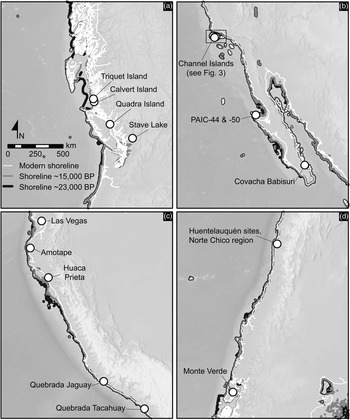
Around the North Pacific Rim, the destructive effects of other taphonomic processes—earthquakes, tsunamis, marine erosion, coastal development, and others—are more difficult to quantify (e.g., Erlandson Reference Erlandson2012; O'Rourke Reference O'Rourke2017). Coastal archaeologists are increasingly aware of the dramatic loss of cultural deposits to such destructive processes, by which sites can melt into the sea either slowly over months or years or catastrophically in a matter of hours or days. Such processes make certain coastlines particularly poor places to look for early sites. From northern California to southern British Columbia (BC), for example, recurrent earthquakes and tsunamis along the Cascadia Subduction Zone have resulted in subsidence and massive erosion along the coast, impacting archaeological records and making this region particularly challenging for locating early archaeological sites (Davis et al. Reference Davis, Jenevein, Punke, Noller, Jones, Willis, O'Connor, Dorsey and Madin2009; Erlandson et al. Reference Erlandson, Tveskov and Byram1998; Moss and Erlandson Reference Moss and Erlandson1995). Archaeologists have had success, however, in systematically searching for early sites along three regions of the New World Pacific Coast: the northern Northwest Coast, the islands of Alta and Baja California, and the arid coasts of Peru and Chile (Figure 2).
Locations of coastal or near-coastal archaeological sites more than 11,000 years old in (a) the Pacific Northwest; (b) Baja and southern Alta California; (c) Ecuador and Peru; and (d) Chile. See Figure 1 for the extent of each map. Approximate shorelines at 23,000 cal BP and 15,000 cal BP are modeled on the ICE-6G model (Argus et al. Reference Argus, Peltier, Drummond and Moore2014; Peltier et al. Reference Peltier, Argus and Drummond2015) and ETOPO1 Global Relief Model (Amante and Eakins Reference Amante and Eakins2009).

Locating early sites in coastal southeast Alaska and BC is challenging because of the dynamic history of regional paleogeography, especially with regard to deglaciation, isostatic rebound, and regional sea-level histories (Darvill et al. Reference Darvill, Menounos, Goehring, Lian and Caffee2018; Lesnek et al. Reference Lesnek, Briner, Lindqvist, Baichtal and Heaton2018; Mackie et al. Reference Mackie, Fedje and McLaren2018). Some shorelines dating to 14,500 years ago are 150 m below modern mean sea level (MSL) off Haida Gwaii, 3 to 4 m below modern MSL in the Hakai Passage area of the BC central coast, and 200 m above MSL on Quadra Island in the northern Salish Sea (|Fedje et al. Reference Fedje, Mackie, Wigen, Mackie, Lake, Fedje and Mathewes2005, Reference Fedje, McLaren, James, Mackie, Smith, Southon and Mackie2018; McLaren et al. Reference McLaren, Fedje, Dyck, Mackie, Gauvreau and Cohen2018). Along the northern Northwest Coast, paleoshorelines of this age and earlier have seen limited investigation because of low site visibility in coastal rainforests, limited access to remote subaerial or submerged study areas, the lack of high-resolution baseline data and focused high-potential landform modeling, and relatively low funding levels for terminal Pleistocene archaeological research projects.
In the last decade, following meticulous reconstruction of local sea-level records and paleoshorelines, there have been significant discoveries of early post-glacial to earliest Holocene archaeological sites on the BC coast. In Haida Gwaii, the earliest coastal sites should be deeply drowned. The earliest documented sites associated with paleoshorelines in this area date to approximately 11,000–11,500 years ago, but several inland bear-hunting sites provide a small window into human use of the landscape between 12,500 and 12,800 years ago (Fedje et al. Reference Fedje, Mackie, Lacourse and McLaren2011). In the Hakai Pass area, several early sites have recently been found associated with paleoshorelines 1–4 m below modern MSL. Examples include Pruth Bay on Calvert Island where human footprints and stone tools have been dated to ~13,000 cal BP (McLaren et al. Reference McLaren, Fedje, Dyck, Mackie, Gauvreau and Cohen2018). About 10 km to the west, preliminary work at the base of the deeply stratified Triquet Island site documented chipped stone artifacts associated with a hearth feature dating to ~13,800 cal BP (Gauvreau and McLaren Reference Gauvreau and McLaren2017). Recent work on Quadra Island discovered limited evidence of human use of paleoshorelines about 30 m above modern MSL dated to ~13,000 cal BP (Fedje et al. Reference Fedje, McLaren, James, Mackie, Smith, Southon and Mackie2018), and several sites at Stave Lake in the Fraser River lowlands date from 12,300 to 12,000 years ago (McLaren Reference McLaren and Rousseau2017).
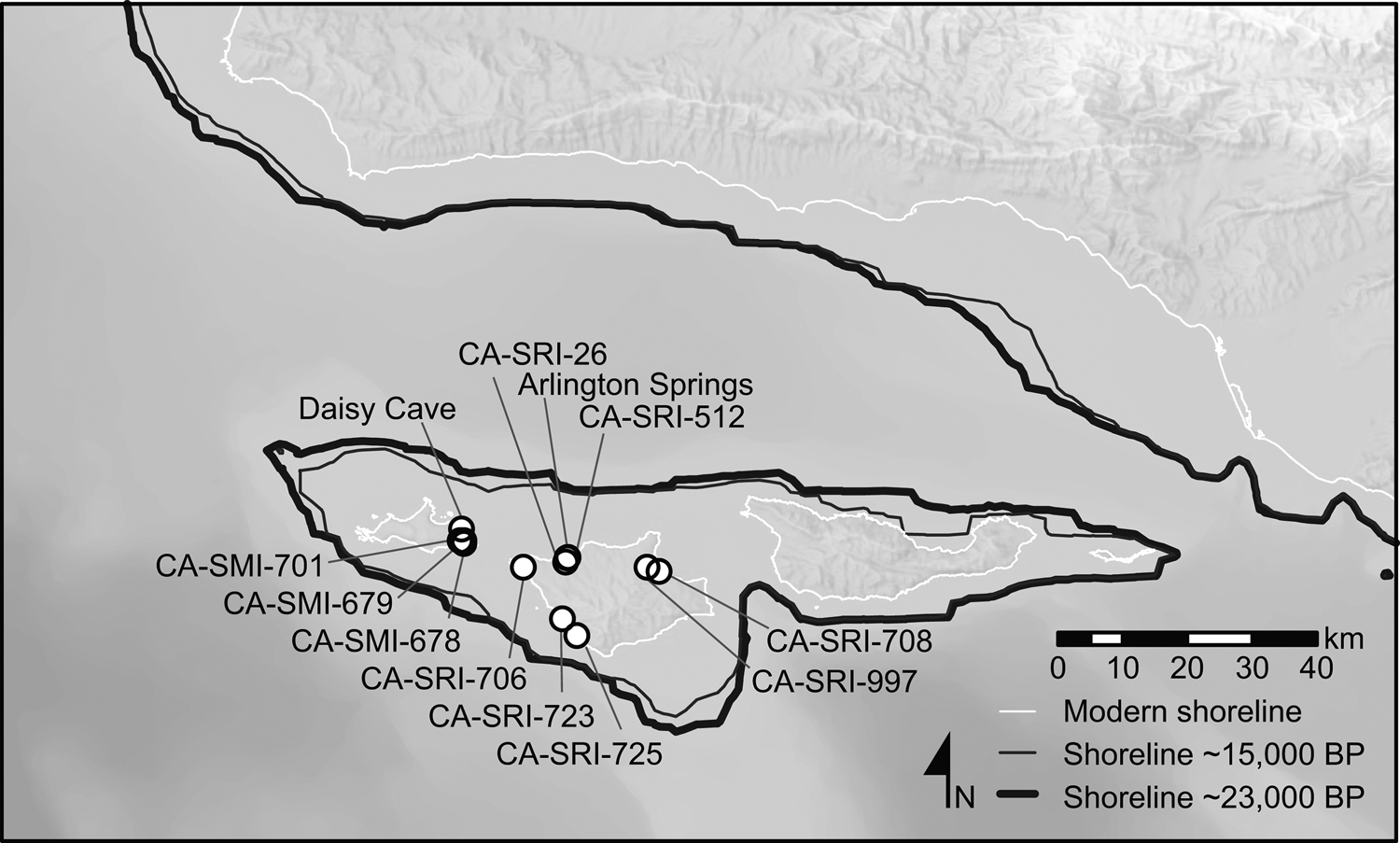
The islands of Alta and Baja California also have proved fruitful in the search for terminal Pleistocene and earliest Holocene archaeological sites. Despite the loss of nearly 75% of their land area since the LGM, the Northern Channel Islands have produced dense concentrations of terminal Pleistocene and Early Holocene sites (Figure 3). This includes four sites on San Miguel Island (CA-SMI-261, -678, -679, -701) and eight on Santa Rosa Island (CA-SRI-26, -173, -723, -512, -706, -708, -725, -997/H) with cultural components securely dated between ~13,000 and 11,000 cal BP (Erlandson et al. Reference Erlandson, Kennett, Lynn Ingram, Guthrie, Morris, Tveskov, James West and Walker1996, Reference Erlandson, Rick, Braje, Casperson, Culleton, Fulfrost, Garcia, Guthrie, Jew, Kennett, Moss, Reeder, Skinner, Watts and Willis2011; Gusick and Erlandson Reference Gusick, Erlandson, Gill, Fauvelle and Erlandson2019; Johnson et al. Reference Johnson, Stafford, Ajie, Morris, Browne, Mitchell and Chaney2002; Rick et al. Reference Rick, Erlandson, Jew and Reeder-Myers2013). Most of these sites are situated between 2 and 10 km inland from contemporary shorelines, where occupants gathered shellfish, fished, and hunted marine mammals and seabirds. Most of these sites have produced chipped stone crescents, stemmed points, and foliate bifaces, and scores of them have been found in situ within stratified and well-dated deposits.
Locations of coastal or near-coastal archaeological sites more than 11,000 years old in the Northern Channel Islands. See Figure 2 for map extent. Approximate shorelines at 23,000 cal BP and 15,000 cal BP are modeled on the ICE-6G model (Argus et al. Reference Argus, Peltier, Drummond and Moore2014; Peltier et al. Reference Peltier, Argus and Drummond2015) and ETOPO1 Global Relief Model (Amante and Eakins Reference Amante and Eakins2009).

Two islands off Baja California, Cedros and Espíritu Santo, have also produced evidence of terminal Pleistocene occupations. On Isla Cedros, radiocarbon dating of shell midden strata at PAIC-44 and -49 has documented diversified maritime foraging, fishing, and hunting activities at ~12,000 cal BP (Des Lauriers Reference Des Lauriers2010; Des Lauriers et al. Reference Des Lauriers, Davis, Turnbull, Southon and Taylor2017). On Isla Espíritu Santo, just inside the Gulf of California near the southern tip of Baja California Sur, Covacha Babisuri cave has yielded evidence of early maritime adaptations dated to ~12,350 cal BP (Fujita Reference Fujita2010).
There is growing evidence for terminal Pleistocene humans along portions of the Pacific Coast of South America. The earliest evidence comes from the Monte Verde II (~14,500–14,000 cal BP) and Huaca Prieta (15,000–13,500 cal BP) sites in Chile and Peru, respectively (Dillehay et al. Reference Dillehay, Ramírez, Pino, Collins, Rossen and Pino-Navarro2008, Reference Dillehay, Bonavia, Goodbred, Pino, Vásquez and Tham2012). Other early evidence comes from the north and south coasts of Peru, from the basal levels at Quebrada Jaguay (~13,000 cal BP) and Quebrada Tacahuay (~12,900 cal BP), as well as the Amotape sites (tentatively dated to ~12,300 cal BP). The coast of Chile has also produced the Norte Chico (~13,000 cal BP) and Huentelauquen (~11,700 cal BP) complexes (Suárez and Ardelean Reference Suárez and Ardelean2019). Less secure data come from the pre–Las Vegas site in southern Ecuador dated to ~13,000 cal BP (Stothert et al. Reference Stothert, Piperno and Andres2003). Evidence from several Fishtail and Paiján sites (~13,000–10,000 cal BP) located between 30 and 80 km inland in Peru's Andean foothills also reveals contact with the coast, either through direct procurement of marine resources or exchange with coastal groups. The economy of all the South American coastal sites is broad-spectrum foraging of marine resources (e.g., sea lions, shellfish, fish, seaweed) in nearshore marine or estuarine ecosystems, with exchange or direct procurement of inland and/or highland plants and animals (e.g., at pre–Las Vegas, Huaca Prieta, Quebrada Jaguay). Included in these early economies is ~12,000 cal BP mining of iron oxide on the north-central coast of Chile (Salazar et al. Reference Salazar, Jackson, Guendon, Salinas, Morata, Figueroa, Manríquez and Castro2011).
Stemmed Points, Foliate Bifaces, and Lunates: Technological Connections around the North Pacific Rim?
When the Clovis-first model dominated studies of the peopling of the Americas, archaeologists assumed that technological links between Clovis points and ancestral traditions in Siberia needed only to be found to connect the dots of population dispersal across the Bering Land Bridge and down the IFC. After decades of study and tenuous connections to traditions in the Far North such as the Denali or Nenana complexes, we now know that Clovis technology was a New World invention, a conclusion supported by recent morphometric and cladistic analyses (Smith and Goebel Reference Smith and Goebel2018). The earliest Americans arrived with some yet to be fully identified technological tool kit.
Beck and Jones (Reference Beck and Jones2010) reignited a long-standing debate in western North American archaeology, arguing that the Western Stemmed Tradition (WST) was technologically distinct from Clovis, potentially older, and possibly related to a coastal dispersal of people from northeast Asia into the Americas. Critics have challenged this hypothesis (Potter, Baichtal et al. Reference Potter, Baichtal, Beaudoin, Fehren-Schmitz, Vance Haynes, Holliday, Holmes, Ives, Kelly, Llamas, Malhi, Miller, Reich, Reuther, Schiffels and Surovell2018), arguing that stems are not technologically or temporally diagnostic and that there has been no detailed technological study connecting the widely varied stemmed point types found scattered from Japan to Kamchatka, the PNW and California Islands, and South America (see Erlandson and Braje Reference Erlandson and Braje2011).
Stemmed and lanceolate projectile points appeared in northeast Asia before the LGM and persisted into the Holocene (Nagai Reference Nagai2007), quite different from the tighter geographic and chronological ranges of fluted points in the Americas. Terminal Pleistocene stemmed point traditions around the Pacific Rim are broadly similar, but they occur over thousands of kilometers and more than 5,000 years, leaving any technological relationship between them uncertain (Erlandson and Braje Reference Erlandson and Braje2011). Some Incipient Jomon assemblages show remarkable technological similarities to early Channel Island Paleocoastal assemblages, however, with foliate bifaces, stemmed and barbed points, and lunates reminiscent of the crescents often found in WST assemblages in North America's Far West. At Paisley Caves, accessible from the coast via the Klamath and Sprague River corridors (Pitblado Reference Pitblado2011), stemmed points are minimally dated to ~13,000–12,700 cal BP—with no evidence of Clovis technology being present—making them at least coeval with Clovis (Jenkins et al. Reference Jenkins, Davis, Stafford, Campos, Hockett, Jones, Cummings, Yost, Connolly, Yohe, Gibbons, Raghavan, Rasmussen, Paijmans, Hofreiter, Kemp, Barta, Monroe, P. Gilbert and Willerslev2012), and similar ages are suggested at a few other sites (Davis et al. Reference Davis, Nyers and Willis2014). At the Friedkin and Gault sites in central Texas, stemmed points have been found stratigraphically below Clovis and dated as much as 2,000 years older than Clovis (Waters, Forman et al. Reference Waters, Forman, Jennings, Nordt, Driese, Feinberg, Keene, Halligan, Lindquist, Pierson, Hallmark, Collins and Wiederhold2011; Waters et al. Reference Waters, Keene, Forman, Prewitt, Carlson and Wiederhold2018; Williams et al. Reference William, Collins, Rodrigues, Rink, Velchoff, Keen-Zebert, Gilmer, Frederick, Ayala and Prewitt2018).
The connection between stemmed point varieties around the Pacific Rim remains tenuous, but it is an important avenue for future research. For now, the presence of stemmed points and crescents in many Paleocoastal assemblages provides strong links to the WST. Crescents also represent a technology distinct from Clovis and other early fluted traditions with which they rarely co-occur. Crescents occur in a variety of shapes and sizes but come in classic lunate, butterfly, and eccentric varieties (Sanchez et al. Reference Sanchez, Erlandson and Tripcevich2017). Common in WST assemblages from wetland settings of the Columbia Plateau, Great Basin, and Alta and Baja California, crescents are thought to be associated with the hunting of aquatic and marine birds (Moss and Erlandson Reference Moss and Erlandson2013).
Given such similarities, suggesting that stemmed points are “not an appropriate derived character on which to base a hypothesis of cultural affiliation” (Potter, Baichtal et al. Reference Potter, Baichtal, Beaudoin, Fehren-Schmitz, Vance Haynes, Holliday, Holmes, Ives, Kelly, Llamas, Malhi, Miller, Reich, Reuther, Schiffels and Surovell2018) seems premature, especially given the co-occurrence of foliates, stemmed points, and lunates from Incipient Jomon, early Channel Island, and WST assemblages. In the lower Pacific Northwest region, however, foliate and stemmed points may have been produced from distinct cultural and temporal traditions (see Chatters et al. Reference Chatters, Hackenberger, Lenz, Prentiss, Thomas, Bousman and Vierra2012), which suggests that these technologies do not always co-occur and also highlights their potential for understanding the spread of cultural traditions through space and time. Much remains to be learned about the morphological similarities and differences between early stemmed point assemblages and traditions around the Pacific Rim, but potential connections should not be dismissed, especially given genomic evidence for a similar distribution of some Paleo-American genetic lineages (see below).
Searching beneath the Waves
One of the last frontiers in studying the peopling of the Americas is the drowned coastlines and paleolandscapes of the eastern Pacific and broader Pacific Rim. We know humans occupied interior regions of the Americas as early as the terminal Pleistocene, meaning that the margins of the world they inhabited were flooded and reshaped by more than seven millennia of sea-level rise and post-glacial warming. Locating, sampling, and interpreting the archaeological evidence of Paleocoastal settlement along submerged coastlines is technically challenging, but this is an emerging focus for a variety of interdisciplinary scholars who are centering their research efforts off the Pacific Coast of North America (Fedje et al. Reference Fedje, McLaren, James, Mackie, Smith, Southon and Mackie2018; Gusick, Maloney, Braje et al. Reference Braje, Maloney, Erlandson, Driscoll, Davis, Miller and Gusick2019; Monteleone et al. Reference Monteleone, James Dixon and Wickert2013).
Some of the earliest efforts to locate and sample submerged Pacific Coast sites were intertidal lithic sites in British Columbia (Fladmark Reference Fladmark1979) and a submerged Middle Holocene shell midden in Montague Harbour (Easton and Moore Reference Easton and Moore1991). While it is too young to apply directly to the first Americans, the Montague Harbour site demonstrated that submerged sites can be preserved along a North Pacific coast generally characterized by high wave energy. Later researchers created paleolandscape reconstructions of the continental shelf and collected core and grab samples in areas identified as having high potential for preserved prehistoric cultural resources (Fedje and Josenhans Reference Fedje and Josenhans2000; Josenhans et al. Reference Josenhans, Fedje, Conway and Vaughn Barrie1995, Reference Josenhans, Fedje, Pienitz and Southon1997). Their efforts yielded a flaked stone tool from an associated soil on the sea floor approximately 60 m below BC's Hecate Strait. This was followed by a series of intertidal discoveries on Haida Gwaii that included a stratified and well-preserved shell midden (e.g., Kilgii Gwaay) in a submerged intertidal setting dated between 10,700 and 10,600 cal BP (Fedje et al. Reference Fedje, Mackie, Wigen, Mackie, Lake, Fedje and Mathewes2005). The human footprints from Calvert Island extend the age of submerged coastal sites in BC to at least 13,000 cal BP (McLaren et al. Reference McLaren, Fedje, Dyck, Mackie, Gauvreau and Cohen2018).
To date, all other submerged precontact terrestrial archaeological material identified off the west coast of the Americas (excluding fish weirs) have been chance finds from southern California (Masters Reference Masters, Masters and Flemming1983) and shallow submerged middens in San Francisco Bay (Bickel Reference Bickel1978). Projects in Beringia and Southeast Alaska (Dixon and Monteleone Reference Dixon, Monteleone, Evans, Flatman and Flemming2014); off the Washington, Oregon, and California coasts (Fedje and Josenhans Reference Fedje and Josenhans2000; Gusick, Maloney, Braje et al. Reference Braje, Maloney, Erlandson, Driscoll, Davis, Miller and Gusick2019; Watts et al. Reference Watts, Fulfrost, Erlandson and Ford2011); and in the Gulf of California (Gusick and Davis Reference Gusick and Davis2010) have all focused on paleolandscape and paleoenvironmental reconstruction using geographic information system (GIS) models and remote sensing equipment to identify landscapes of interest for both biological and archaeological sensitivity (see Figure 1).
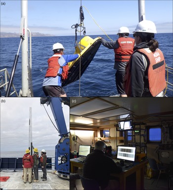
The goal of this nascent research is to establish a framework on which to build projects that can consistently identify submerged terminal Pleistocene sites, using seismic profiling systems, side scan sonar, and multibeam bathymetry to reconstruct paleolandscape features and paleodrainages. Current large-scale projects off the coasts of British Columbia, Oregon, and California are using these methods to target anomalies for testing via coring, grab samples, or diver/remote-operated vehicle (ROV) investigation (Figure 4; Gusick, Maloney, King et al. Reference Gusick, Maloney, King and Braje2019; Mackie et al. Reference Mackie, Davis, Fedje, McLaren, Gusick, Waters and Graff2013). Beginning in locations where subaerial terminal Pleistocene sites have been identified, these multidisciplinary efforts are providing the geophysical baseline data required to understand the regional evolution of paleolandscapes and paleoecologies. Data related to shallow seafloor stratigraphy, paleodrainage morphology and evolution, and submerged paleoshorelines have improved archaeological sensitivity models and formed the foundation for more targeted investigations on terminal Pleistocene-aged submerged landscapes. These projects are also helping define best practices (Gusick and Faught Reference Gusick, Faught, Bicho, Haws and Davis2011; Gusick, Maloney, King et al. Reference Gusick, Maloney, King and Braje2019; Mackie et al. Reference Mackie, Davis, Fedje, McLaren, Gusick, Waters and Graff2013) for eastern Pacific continental-shelf archaeology and exploring new technologies for advancing the discipline (King et al. Reference King, Maloney, Constable, Gusick, Braje and Ball2018).
Photographs from underwater research being conducting off the coast of southern California and central Oregon (photos by Amy Gusick): (a) preparing to launch a Compressed High-Intensity Radiated Pulse (CHIRP) system to map the sea floor and subbottom; (b) inspecting a seafloor core, collected to sample paleolandscape features; (c) analyzing data aboard ship during geophysical surveys of the ocean floor. (Color online)

Melding Datasets from Genetics, Archaeology, Paleoecology, and Linguistics
Genetic approaches to understanding the peopling of the Americas have transformed the field in recent years, challenging hypotheses such as Clovis-first and the Solutrean connection as well as revealing extraordinary complexity in the origins and dispersal of Indigenous peoples of the Americas. Paleogenomic studies of population relationships and sources of ancestry are rapidly evolving and—coupled with archaeological, paleoecology, and linguistic data—offer insights into the routes and timing of the earliest human dispersals into the Americas. Paleogenetic relationships and chronologies should be interpreted cautiously, however, as the field is rapidly evolving and is still dealing with significant interpretive hurdles such as accurately setting genetic mutation rates and extrapolating from small sample sizes, especially for aDNA from human remains dating to the terminal Pleistocene and Early Holocene.
Sikora and colleagues (Reference Sikora, Pitulko, Sousa, Allentoft, Vinner, Rasmussen, Margaryan, de Barros Damgaard, de la Fuente, Renaud, Yang, Fu, Dupanloup, Giampoudakis and Nogués-Bravo2019) reported the sequencing of high-quality genomes from two unrelated male children at Yana RHS. These genomes suggest the presence of a large and genetically diverse population (with an effective population size of 500 individuals) living above the Arctic Circle by 31,600 cal BP. These “Ancient North Siberians” (ANS) appear to have been directly ancestral to the Ancient North Eurasians (ANE) represented by the ~24,000-year-old Mal'ta genome (with additional ancestry from other early populations). Sikora and colleagues (Reference Sikora, Pitulko, Sousa, Allentoft, Vinner, Rasmussen, Margaryan, de Barros Damgaard, de la Fuente, Renaud, Yang, Fu, Dupanloup, Giampoudakis and Nogués-Bravo2019) also sequenced the genome of a 9800 cal BP individual from the Kolyma1 site in northeast Siberia, revealing the presence of a population closely related to Native Americans (“Ancient Paleosiberians”). Kolyma1 and the Yana children's genomes add to our understanding of events leading to the formation of the Native American gene pool. Sikora and colleagues (Reference Sikora, Pitulko, Sousa, Allentoft, Vinner, Rasmussen, Margaryan, de Barros Damgaard, de la Fuente, Renaud, Yang, Fu, Dupanloup, Giampoudakis and Nogués-Bravo2019) suggest that Ancient Paleosiberians, Ancient Beringians, and Native Americans all descended from a population that separated from East Asians approximately 30,000 years ago (range 26,800–36,400 cal BP); the population ancestral to Kolyma1 may have split off ~20,900–27,900 cal BP.
The gene flow event from ANS into the East Asian ancestors of North Americans (sometime between 13,300 and 23,500 cal BP) separately impacted the ancestors of Kolyma1 at about the same time (15,500–23,700 cal BP). It is still unclear where this population contraction took place because there is no direct archaeological evidence of these events. Sikora and colleagues (Reference Sikora, Pitulko, Sousa, Allentoft, Vinner, Rasmussen, Margaryan, de Barros Damgaard, de la Fuente, Renaud, Yang, Fu, Dupanloup, Giampoudakis and Nogués-Bravo2019) modeled Siberian paleoclimactic conditions during the LGM to identify possible geographic candidates for the isolation event, and they found evidence for a refugium in southeastern Beringia and “a coastal corridor along the Sea of Okhotsk and the Kamchatka Peninsula” during the LGM (see also Hoffecker et al. Reference Hoffecker, Elias, O'Rourke, Richard Scott and Bigelow2016).
During the Beringian “standstill,” which may be supported by controversial evidence for people in northern Yukon's Bluefish Caves approximately 24,000 years ago (Bourgeon et al. Reference Bourgeon, Burke and Higham2017), the ancestors of Native Americans diverged at least three times. The Ancient Beringians, represented by the Upward Sun River (Moreno-Mayar, Potter et al. Reference Moreno-Mayar, Potter, Vinner, Steinrücken, Rasmussen, Terhorst, Kamm, Albrechtsen, Malaspinas, Sikora, Reuther, Irish, Malhi, Orlando, Song, Nielsen, Meltzer and Willerslev2018) and Trail Creek Caves (Moreno-Mayar, Vinner et al. Reference Moreno-Mayar, Vinner, de Barros Damgaard, de la Fuente, Chan, Spence, Allentoft, Vimala, Racimo, Pinotti, Rasmussen, Margaryan, Iraeta Orbegozo, Mylopotamitaki and Wooller2018) genomes, may have diverged from the ancestors of other Native Americans between ~22,000 and 18,100 cal BP. Another group, detected via its contributions to the ancestry of the Mixe people but not yet directly sampled, is hypothesized to have diverged ~24,700 cal BP (30,000–22,000 years ago). The third group moved south of the ice sheets, giving rise to populations in North and South America.
Those who left Alaska gave rise to at least three genetically distinguishable groups: Northern Native Americans (NNA), Southern Native Americans (SNA), and a third group represented by the genome of a 5,600-year-old individual from Big Bar Lake (Moreno-Mayar, Vinner et al. Reference Moreno-Mayar, Vinner, de Barros Damgaard, de la Fuente, Chan, Spence, Allentoft, Vimala, Racimo, Pinotti, Rasmussen, Margaryan, Iraeta Orbegozo, Mylopotamitaki and Wooller2018). The NNA include the Algonquian, Na-Dené, Salishan, and Tsimshian, and the SNA include the Anzick-1 Paleoindian child and all ancient and contemporary peoples of Central and South America.
Recent interpretations suggest that NNA and SNA may have diverged from each other between ~17,500 and 14,600 cal BP (Moreno-Mayar, Vinner et al. Reference Moreno-Mayar, Vinner, de Barros Damgaard, de la Fuente, Chan, Spence, Allentoft, Vimala, Racimo, Pinotti, Rasmussen, Margaryan, Iraeta Orbegozo, Mylopotamitaki and Wooller2018; Rasmussen et al. Reference Rasmussen, Anzick, Waters, Skoglund, DeGiorgio, Stafford, Rasmussen, Moltke, Albrechtsen, Doyle, Poznik, Gudmundsdottir, Yadav, Malaspinas and Stockton White2014). The NNA, SNA, and Big Bar Lake populations seem to be equally related to the Ancient Beringian population, who were found at widely separated Upward Sun (interior Alaska) and Trail Creek Cave (Seward Peninsula) localities in Alaska. Currently, the most parsimonious explanation for these results is that the ancestors of NNA-SNA-Big Bar Lake moved south of the ice sheets sometime prior to their split (17,500–14,600 years ago). The Big Bar Lake population diverged first, followed by the NNA-SNA divergence. Following these initial divergences, there was a very rapid population radiation throughout North and South America “akin to leap-frogging across large portions of the diverse intervening landscape” rather than gradual expansion (Moreno-Mayar, Vinner et al. Reference Moreno-Mayar, Vinner, de Barros Damgaard, de la Fuente, Chan, Spence, Allentoft, Vimala, Racimo, Pinotti, Rasmussen, Margaryan, Iraeta Orbegozo, Mylopotamitaki and Wooller2018:362). This pattern currently fits the expected predictions of a rapid and early coastal dispersal—perhaps facilitated by familiarity with similar marine resources (shellfish, fish, sea mammals, seabirds, seaweed) along Pacific Rim coastlines (Erlandson et al. Reference Erlandson, Graham, Bourque, Corbett, Estes and Steneck2007, Reference Erlandson, Braje, Gill and Graham2015)—more than a later (and slower) overland movement through the IFC and subsequent population expansion.
Concluding Remarks
During the 40 years since the publication of Fladmark's (Reference Fladmark1979) landmark paper exploring the PCR as a potential entry point into the Americas, archaeologists have made significant progress in identifying early coastal sites. This includes identification of numerous sites in North America dated to the terminal Pleistocene and Early Holocene, as well as a few sites in or near coastal South America dated to approximately 14,500 years ago. Critics of the PCR point to the absence or dearth of Clovis-aged or older sites along the route (e.g., Potter, Baichtal et al. Reference Potter, Baichtal, Beaudoin, Fehren-Schmitz, Vance Haynes, Holliday, Holmes, Ives, Kelly, Llamas, Malhi, Miller, Reich, Reuther, Schiffels and Surovell2018, Potter, Beaudoin et al. Reference Potter, Beaudoin, Vance Haynes, Holliday, Holmes, Ives, Kelly, Llamas, Malhi, Miller, Reich, Reuther, Schiffels and Surovell2018). This is an important point, but we note that Clovis-aged or older sites are also currently absent within the central IFC.
When compared to the IFC and other interior regions of North America, the Pacific Rim's terminal Pleistocene shorelines remain largely submerged and unexplored. Recent research documents that such shorelines are located above sea level in some areas of the northern Northwest Coast (Mackie et al. Reference Mackie, Fedje and McLaren2018; Potter, Baichtal et al. Reference Potter, Baichtal, Beaudoin, Fehren-Schmitz, Vance Haynes, Holliday, Holmes, Ives, Kelly, Llamas, Malhi, Miller, Reich, Reuther, Schiffels and Surovell2018), but a systematic search of these ancient shorelines for archaeological sites is in its early stage. Where such surveys have been performed in the context of a detailed understanding of sea-level histories and paleolandscape reconstructions, they have been highly successful (see McLaren et al. Reference McLaren, Fedje, Dyck, Mackie, Gauvreau and Cohen2018). Underwater archaeology of Pacific Rim shorelines has been even rarer—especially in Northeast Asia, Beringia, and South America. Even along the Pacific Coast of North America, systematic underwater research is largely just beginning, and the dynamic nature of coastal environments—including post-glacial sea-level rise, high wave energy, and marine erosion—pose formidable challenges to site preservation and discovery. Questions persist about the timing and nature of a potential terminal Pleistocene coastal dispersal of AMH from Northeast Asia into the Americas, but we now know that from Canada to California, Mexico, Peru, and Chile, some of the first peoples in the Americas exploited a wide range of marine and estuarine resources; used stemmed points, foliate bifaces, lunates (crescents), and other technologies; and likely constructed relatively sophisticated watercraft. Such findings would have been deemed implausible to most archaeologists just 30 years ago (e.g., Aikens Reference Aikens1990:12).
Archaeologists searching for early sites along the IFC and the PCR face similar challenges—working in remote locations, narrowing search targets, confronting millennia of taphonomic processes that may have destroyed or buried sites, to name a few. While efforts should continue in both areas, the reality is that, unlike the search for sites in the IFC—where formidable challenges such as dense vegetation cover, vast search areas, and remote locations continue to plague archaeological research efforts—archaeological investigations of submerged Pacific Coast landscapes have just begun, and it may be many years before we have a better resolution of the history of human occupation of Pacific Coast paleolandscapes. Although the continental shelf of the eastern Pacific has yet to yield the same type of underwater discoveries as the Gulf of Mexico or Florida's inland waters (e.g., Dunbar et al. Reference Dunbar, Faught and Webb1988; Faught Reference Faught2004; Halligan et al. Reference Halligan, Waters, Perrotti, Owens, Feinberg, Bourne, Fenerty, Winsborough, Carlson, Fisher, Stafford and Dunbar2016), scientists are building a strong case for early human coastal occupation through incremental discoveries that advance our understanding of submerged paleolandscapes, which form the framework for future discoveries that may change what we thought we knew about the peopling of the New World.
Despite numerous advances, American archaeology remains at a crossroads with one of its most fundamental questions left unanswered: how and when did the first humans arrive in the western hemisphere? Both the IFC and PCR remain viable colonization pathways, and continued archaeological, paleoenvironmental, and genetic studies are necessary along these and other potential routes. Serious archaeological research on the PCR as a potential early human dispersal corridor, however, has only emerged in the last two to three decades—thanks largely to the pioneering efforts of Knut Fladmark (Reference Fladmark1979). We should be open to reexamining long-held assumptions about Paleoindian cultures, evaluated and codified when Clovis was first and the IFC dominated archaeological thought. Evaluating these assumptions will take time and effort, and such research is in its early stages. Suggesting that “Paleoindian industries are . . . generally terrestrial, with limited evidence of coastal exploitation in lower-latitudes” (Potter, Baichtal et al. Reference Potter, Baichtal, Beaudoin, Fehren-Schmitz, Vance Haynes, Holliday, Holmes, Ives, Kelly, Llamas, Malhi, Miller, Reich, Reuther, Schiffels and Surovell2018) may ultimately prove to be a reflection of the differential preservation of early coastal versus interior sites and a long-standing terrestrial focus of archaeological inquiry in the Americas.
When we critically evaluate the IFC and PCR pathways, some of the same shortcomings manifest. The lack of universally accepted pre-Clovis-aged sites along the PCR remains a significant obstacle, but the same is true of the central IFC, where the earliest known sites are a millennium younger than classic Clovis and the earliest well-documented coastal sites. Earlier IFC sites may be found, linking the early interior records of Beringia and mid-latitude North America, but there is currently no compelling archaeological evidence for an initial peopling via the IFC. Taphonomic issues may explain the difficulty in discovering earlier IFC sites, but such arguments are equally or even more valid for the Pacific Coast of the Americas. As Madsen noted:
While there are some ancillary data supporting the notion of an early spread of foraging populations along the west coast of the Americas, little direct evidence has been found that provides definitive support. On the other hand, there is no contradictory evidence that the Pacific coast model is wrong. The ice-free corridor/Clovis First model is more readily testable since it does not involve areas now covered by a rise in post-glacial sea level. The model can be faulted by (1) evidence that the ice-free corridor was not open sufficiently early to allow for the dispersal of Clovis peoples, (2) evidence for the presence of contemporary groups in both North and South America using different lithic technologies, (3) evidence that the earliest Clovis sites lie well south of the ice-free corridor, and (4) evidence there were people in the Americas well before the appearance of Clovis tools and technology [Madsen Reference Madsen2015:233].
Given the challenges affecting the search for the earliest sites in the PCR and IFC routes, neither the evidence for a coastal or interior dispersal refutes the existence of the other. Current evidence supports multiple potential pathways for the peopling of the Americas, including interior and coastal routes, all taking place within a few short millennia. Currently, the PCR appears to have been viable approximately 2,000 years earlier than the IFC, but the challenge is to determine if pre-Clovis aged coastal sites exist in the area, with underwater and other research having the greatest potential to confirm or refute this as the earliest dispersal route into the Americas. Shattering the Clovis barrier was critical in advancing research on the peopling of the Americas over the last few decades, and interdisciplinary research of both coastal and interior routes will be crucial for moving forward in the twenty-first century.
Acknowledgments
Thanks to Lynn Gamble and the production team at American Antiquity for all their help in the review, revision, and publication of our manuscript. We also thank the three anonymous reviewers for their helpful suggestions on an earlier version of our manuscript and our home institutions for their support of our research. We dedicate this paper to Knut Fladmark for his pioneering efforts to help bring the “coastal migration theory” and PCR into focus as a viable hypothesis for the initial peopling of the Americas.
Data Availability Statement
All data for this review paper was culled from published sources.