

INTRODUCTION
The Kuju volcanic group, located in central Kyushu, Japan (Figure 1a), consists of more than 20 small stratovolcanoes and lava domes (Kawanabe et al. Reference Kawanabe, Hoshizumi, Itoh and Yamasaki2015). In the central part of the group (Figure 1b), the majority of the lavas formed hornblende-andesitic and dacitic lava domes (Ohta Reference Ohta1991). Kamata and Kobayashi (Reference Kamata and Kobayashi1997) established the tephra-stratigraphy above the Aira-Tn (AT) ash (30 cal ka BP) and demonstrated its eruptive history through the last 15,000 yr using radiocarbon ages of paleosols intercalated with fallout tephras. However, the stratigraphic position of the lavas remained unclear due mainly to the difficulty of preserving tephra layers in the mountainous area.
(a) Map showing the distribution of volcanoes on Kyushu Island. The rectangle indicates the area of part (b). Dashed lines show the distribution of the Kj-P1 tephra (Nagaoka and Okuno Reference Nagaoka and Okuno2014). Values are in cm. (b) Topographic map of Kuju volcanic group and northern part of Aso caldera. Basement map was prepared by KASHIMIR 3D. The rectangle indicates the area of part (c). Locations A (33°3′21″N, 131°14′56″E), B (33°0′47″N, 131°14′53″E), and C (32°59′4″N, 131°19′44″E) are designated by solid circles. (c) Geological map of the central part of the Kuju volcanic group (modified from Nagaoka and Okuno Reference Nagaoka and Okuno2015). Ak: Akagawa lava; Hs: Hosshozan lava; HsK: Hossho-kita lava; Hz: Hizengajo lava; In: Inaboshiyama lava; Iw: Iwaigodake lava; Kj-Hd: Handa PF deposits; Kj-Mr: Muro PF deposits; Kk: Kutsukakeyama lava; Kr: Kuroiwayama lava; Ks: Kujusan lava; KsM: Kuju-minami lava; KYz: Kami-Yuzawa lava; Mm: Mimatayama lava; MmG: Mimata-Gairinzan lava; Og: Ogigahana lava; OgM: Ogigahana-minami lava; Sn: Sensuizan lava; Sr: Shirakuchidake lava; Tn: Tenbodai lava; and Yb: Mimaya-Yubiyama lava. TL ages are also shown with open circles (Okuno et al. Reference Okuno, Takashima, Nagaoka, Aizawa, Inenaga, Imazato, Obuchi, Fukimoto, Kaneda and Kobayashi2013; Sakaguchi et al. Reference Sakaguchi, Yuhara, Yamasaki, Takashima and Okuno2015).

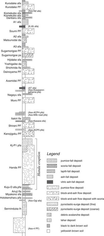
Okuno et al. (Reference Okuno, Takashima, Nagaoka, Aizawa, Inenaga, Imazato, Obuchi, Fukimoto, Kaneda and Kobayashi2013) reported thermoluminescence (TL) ages of lava domes in the central area (Figure 1c). Subsequently, Nagaoka and Okuno (Reference Nagaoka and Okuno2014, Reference Nagaoka and Okuno2015) revised the tephra-stratigraphy of the group (Figure 2). Here, we present accelerator mass spectrometry (AMS) 14C dates of charcoal samples from pyroclastic-flow (PF) deposits to refine the history of the central part of the group.
Columnar section of the tephra layers in the Kuju volcanic group (modified from Nagaoka and Okuno Reference Nagaoka and Okuno2014). Not to scale. Pfa: pumice-fall deposit; sfa: scoria-fall deposit; lfa: lapilli-fall deposit; afa: ash-fall deposit; PF: pyroclastic-flow deposit; ps: pyroclastic-surge deposit; da: debris avalanche deposit; and lh: lahar deposit. Ages of Aso-4, AT, and K-Ah are 89 ka, 30 cal ka BP, and 7.3 cal ka BP, respectively.
METHODS AND MATERIALS
Outline of Geology in Central Part of Kuju Volcanic Group
Plinian eruptions formed the Kuju-D (also named Yutsubo) and Kj-P1 pumice-fall deposits, and have a volume of 6.6 km3 (Figure 1a). During the Plinian eruptions, a portion of the eruption column collapsed and generated the Handa PF deposit (Kj-Hd). The Kj-Hd accumulated to a volume of 5 km3. Both the Kj-P1 and Kj-Hd are continuous eruptive products of the typical intra-Plinian type (Nagaoka and Okuno Reference Nagaoka and Okuno2015). This eruption, beginning with the Kuju-D pumice fall, is collectively named the Handa eruption (Figure 2). The total bulk volume of the erupted tephra could be ~12 km3, corresponding to a volcanic explosivity index (VEI; Newhall and Self Reference Newhall and Self1982) of 5 or 6. Therefore, it might have resulted in the formation of a small-scale caldera. After the Handa eruption, hornblende-andesitic lava domes emerged in the summit area, and associated PF deposits (block-and-ash flow type) flowed down to their foot during the post-caldera stage (Figures 1 and 2). We collected charcoal fragments from the Kj-Hd, Shirani PF (Kj-Sh), and Muro PF (Kj-Mr; also named Nakagumi-bokujo) at locations A and B, respectively (Figure 3).
Photographs showing the Handa (Kj-Hd), Shirani (Kj-Sh), and Muro (Kj-Mr) PF deposits: (a) Location A; (b) Location B

AMS Radiocarbon Dating
The charcoal fragments were cleaned chemically with acid-alkali-acid (AAA) treatment, and combusted to CO2. The CO2 produced was purified cryogenically and then converted catalytically to graphite (Kitagawa et al. Reference Kitagawa, Masuzawa, Nakamura and Matsumoto1993), and measured by the NEC 15SDH-2 AMS system (JAEA-AMS-TONO) at the Tono Geoscience Center, JAEA (Saito-Kokubu et al. Reference Saito-Kokubu, Matsubara, Miyake, Nishizawa, Ohwaki, Nishio, Sanada and Hanaki2015). All three carbon isotopes in both samples and an NIST oxalic acid standard (HOxII) were measured with the system. To estimate the 14C background level, the 14C content of IAEA C1 (marble) was also measured in the same sequence of sample measurements. The 14C age was calculated by subtracting the 14C concentration of the background sample. We corrected for carbon isotopic fractionation using the 13C/12C ratio (δ13CPDB) to determine the conventional 14C age. The 14C errors were evaluated by the 14C reproducibility of repeated measurements on standard targets, and errors in 14C background removal calculations. The obtained 13C/12C ratios were used. Conventional 14C dates were calibrated to a calendar year timescale using the IntCal13 data set (Reimer et al. Reference Reimer, Bard, Bayliss, Beck, Blackwell, Bronk Ramsey, Buck, Cheng, Edwards, Friedrich, Grootes, Guilderson, Haflidason, Hajdas, Hatté, Heaton, Hoffmann, Hogg, Hughen, Kaiser, Kromer, Manning, Niu, Reimer, Richards, Scott, Southon, Staff, Turney and van der Plicht2013) and the computer program CALIB 7.1 (Stuiver and Reimer Reference Stuiver and Reimer1993).
RESULTS AND DISCUSSION
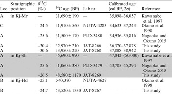
The AMS 14C dates obtained for PF deposits in the group were 53,520±1330 BP (JAT-8267) for Kj-Hd; 48,390±1170 BP (JAT-8269) for Kj-Sh; and 32,970±210 BP (JAT-8266) and 33,950±220 BP (JAT-8268) for Kj-Mr (Table 1). These dates are mostly consistent with their stratigraphic relations and previous dates (Figures 2 and 3). Although the dates for Kj-Hd and Kj-Sh are out of the range of the calibration curve IntCal13, Kj-Mr could be calibrated to 36.5–39 cal kBP (Table 1). Okuno et al. (Reference Okuno, Nakamura, Kamata, Ono and Hoshizumi1998) originally reported AMS 14C dates from locations B and C for eruption age of Kj-Hd. Based on the 14C dates of this study (Table 1), the PF deposit at location C should be correlated with Kj-Mr. Moreover, the dates for Kj-Hd and Kj-Mr allow us to constrain an age of the Kanojigoku PF deposit (Kj-Kn) (Figure 2).
AMS radiocarbon dates of charcoal fragments for the Handa (Kj-Hd), Shirani (Kj-Sh), and Muro (Kj-Mr) PF deposits.

The combination of TL and 14C methods is useful for establishing the eruptive sequence of lava domes and associated PF deposits. TL ages have been reported (Okuno et al. Reference Okuno, Takashima, Nagaoka, Aizawa, Inenaga, Imazato, Obuchi, Fukimoto, Kaneda and Kobayashi2013; Sakaguchi et al. Reference Sakaguchi, Yuhara, Yamasaki, Takashima and Okuno2015; Figure 1c) of ~40–50 ka for the Kutsukakeyama (Kk) and Hossho-kita (HsK) lavas; ~30–40 ka for the Ogigahana-Minami (OgM), Hosshozan (Hs), and Mimata-Gairinzan (MmG) lavas; and ~20–30 ka for the Hizengajo (Hz) and Kujusan (Ks) lavas. These TL ages correspond to the 14C ages for the PF deposits. Therefore, possible sources may be the HsK lava for Kj-Kn; the Kk lava for Kj-Sh; and the OgM, Hs, and MmG lavas for Kj-Mr.
The eruption of Kj-Hd is dated to ~53.5 kBP. This study also revealed that post-caldera volcanism occurred without a significant time interval after caldera formation by the Handa eruption. Regarding pre-caldera volcanism, the TL ages of the Sensuisan (Sn), Ogigahana (Og), and Iwaigo (Iw) lavas have been reported as ~90–60 ka (Okuno et al. Reference Okuno, Takashima, Nagaoka, Aizawa, Inenaga, Imazato, Obuchi, Fukimoto, Kaneda and Kobayashi2013; Figure 1c). Therefore, these lava domes formed intermittently before the caldera formation in the central part of the group.
CONCLUSIONS
We obtained four 14C dates for the Kuju volcanic group from measurements performed at JAEA-AMS-TONO. The Kj-Hd tephra was dated to ~53.5 ka BP, while the two block-and-ash flows, Kj-Sh and Kj-Mr, were dated to ~48.6 and 36.5–39 cal ka BP, respectively. These results, along with the previous TL dates, reveal that the post-caldera volcanism occurred without a significant time interval following caldera formation. As a result, the caldera depression was ponded by both lava domes and pyroclastic-flow deposits. As demonstrated by this study, the TL and 14C methods are very useful tools for establishing the eruptive sequence of lava domes and associated pyroclastic-flow deposits.
ACKNOWLEDGMENTS
This study was financially supported by a Grant-in-Aid for Scientific Research (nos. 21101002, 22240082) from the Japan Society for the Promotion of Science (JSPS) and the Ministry of Education, Culture, Sports, Science and Technology (MEXT), Japan. AMS 14C dating has conducted by AMS (JAEA-AMS-TONO) under the Common-Use Facility Program of JAEA. We thank anonymous reviewers for constructive comments that improved the manuscript.