A REGIONAL FOCUS IN THE BASIN OF MEXICO
Archaeologists often use a regional focus to identify and examine a collection of sites and explore their possible roles in larger social and economic systems. It is easy to understand the importance of this perspective, particularly for complex societies where settlements function in hierarchical systems and have roles both as individual communities as well as parts of larger, multi-settlement entities (Haggett et al. Reference Haggett, Cliff and Frey1977). Indeed, often it seems impossible to understand any individual site in such a sociocultural setting without understanding the role of that site in the broader geographic context. And yet this regional perspective is a relatively recent addition to archaeological inquiry, a perspective whose acceptance developed over time thanks in large part to a handful of key projects conducted in the second half of the twentieth century. Among these projects were the archaeological settlement pattern surveys in the Basin of Mexico.
Much of our understanding of the pre-Columbian Basin of Mexico rests on the collection and analysis of archaeological settlement data. Begun in the Teotihuacan Valley in 1960 (Sanders Reference Sanders1965), the surveys that generated these data included all portions of the basin accessible to surface examination—virtually the entire region with the exception of the area covered by Mexico City and associated sprawl in the southwestern portion of the basin and a relatively small area in the northern basin (Parsons Reference Parsons1974; Sanders Reference Sanders1981; Sanders et al. Reference Sanders, Parsons and Santley1979). These studies provided insights on regional demographics and tendencies in settlement as they evolved over time. Recent completion of a computerized database of the survey data in geographic information system (GIS) format enables examination of such issues with finalized settlement pattern data. It also provides an opportunity to explore particular characteristics of the geographic arrangement of pre-Columbian settlement in the basin as it evolved over time.
The following essay examines some fundamental characteristics of pre-Columbian settlement patterns in the Basin of Mexico using GIS data for the region. The paper begins with a brief overview of the data, focusing on the results of intensive surface surveys of eight regions between 1960 and 1975 and the aggregation of settlement data into a single dataset. It then discusses data compilation, which occurred in two phases. I reexamine certain types of settlement pattern analyses, employing finalized datasets and in some cases considering different measures of demographic change and regional organization. I also analyze pre-Columbian settlement in the basin using various measures and cartographic presentations that are tied to the spatial component of the GIS data, the results providing new ideas about evolving geographic arrangement of settlement in this region. A discussion of shortcomings of the data currently available, and limitations of analyses based upon them, yields a sense of the insights possible from analyses of basin settlement. Finally, I suggest some next steps, both in regional analysis and other types of inquiries, to increase our understanding of changing settlement patterns and sociocultural evolution in the Basin of Mexico.
BASIN OF MEXICO ARCHAEOLOGICAL SETTLEMENT PATTERNS: SURVEYS AND DATA
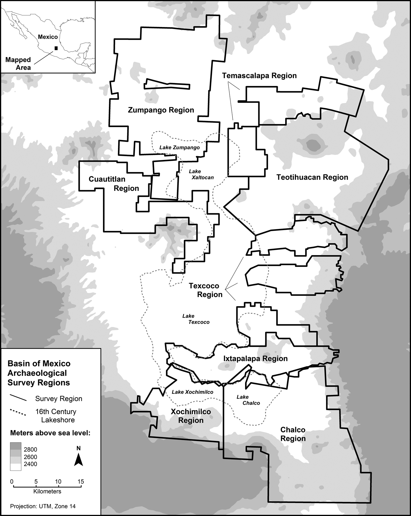
Between 1960 and 1975, archaeologists conducted surface surveys of eight large tracts of land in the Basin of Mexico (Blanton Reference Blanton1972; Evans et al. Reference Evans, Sanders, Parsons, Evans and Sanders2000; Kolb and Sanders Reference Kolb, Sanders and Sanders1996; Marino Reference Marino and Sanders1987; Parsons Reference Parsons1971, Reference Parsons2008; Parsons et al. Reference Parsons, Brumfiel, Parsons and Wilson1982; Sanders Reference Sanders1965; Sanders and Gorenflo Reference Sanders and Gorenflo2007; Sanders et al. Reference Sanders, West, Marino and Fletcher1975) (Figure 1). The goal of these surveys was to locate all archaeological sites in the Basin of Mexico, though with a distinct emphasis on sites with ceramics (Early Formative period and later), to serve as a basis for understanding how pre-Columbian complex societies evolved in the basin at a regional scale. To undertake this task, researchers defined separate geographic regions in the basin and conducted intensive surface surveys of each. With a few exceptions—for instance, narrow sections between main portions of the Texcoco region, and a few areas where field crews were not given access—the surveys examined every part of those regions not obscured by modern infrastructure, such as buildings or roads. In all, the settlement pattern surveys identified more than 3,900 archaeological sites in the Basin of Mexico dating between 1500 b.c. and a.d. 1519 (Gorenflo Reference Gorenflo and Storey2006).
Settlement survey regions in the Basin of Mexico.

The first settlement pattern survey in the Basin of Mexico occurred in the Teotihuacan Valley between 1960 and 1966, directed by William T. Sanders and inspired by both the pioneering archaeological work of Willey (Reference Willey1953) in the Viru Valley of Peru and the cultural geographical research of McBride in highland Guatemala (McBride and McBride Reference McBride and McBride1942). Survey methods evolved during this project, with the approach that emerged serving as a template for surface reconnaissance in the remaining seven portions of the basin (Parsons Reference Parsons2015). Surveys involved crews typically composed of three to five people who walked over prescribed areas and recorded on aerial photographs the archaeological remains that they encountered. Each site represented the physical evidence of past activity, usually occurring as a scatter of artifacts (often pottery sherds, occasionally including obsidian or other lithic material) and occasionally as mounds or other remnants of pre-Columbian structures. The assumption underlying the fieldwork in this and other survey regions was that most sites likely represent the remains of settlements where people lived, the main exceptions being a few isolated hilltop sites that may have served as loci of past ceremonial activity and sites that probably represented the locations of special activities (for example, quarries, irrigation canals). A description of the field methods used in the Basin of Mexico settlement pattern surveys appears in Sanders et al. (Reference Sanders, Parsons and Santley1979).
Beyond the initial inspiration to conduct a regional survey and integrate the survey with the cultural ecology of the area, one of the most important decisions of the Teotihuacan Valley project was to involve Jeffrey Parsons. Beginning as an undergraduate geology major (Parsons Reference Parsons2009, Reference Parsons2015), Parsons was a main contributor to the development of survey methods (Nichols Reference Nichols and Brereton2006). He took the lessons learned in that initial survey and applied similar methods to survey in the Texcoco region (1967), Chalco and Xochimilco regions (1969 and 1972), and the Zumpango region (1973) (see Figure 1). Richard Blanton, a student of Parsons, surveyed the Ixtapalapa region using the same approach in 1969. Through the efforts of Parsons and Blanton, much of the Basin of Mexico accessible to survey was examined between 1967 and 1973.
Augmented by surveys led by Sanders of the Cuautitlan region (in 1974) and the Temascalapa region (in 1974 and 1975), by the mid-1970s nearly 3,100 km2 of the Basin of Mexico had been explored by systematic, intensive surface surveys. Archaeological surveys in the basin recorded similar information for each site, which can be categorized generally as settlement data and environmental data (Gorenflo and Sanders Reference Gorenflo and Sanders2007; Parsons et al. Reference Parsons, Kintigh and Gregg1983).
• Settlement data: Site number (comprising identifiers for survey region and period of occupation, followed by a number), type classification, area (in hectares), population, and a listing of occupations from other periods that occur at the site locality, as well as bookkeeping information that includes the temporary site number assigned during original fieldwork or data compilation, the name of the individual originally recording the site survey information, and the year in which the site was recorded.
• Environmental data: Environmental zone, Universal Transverse Mercator map coordinates for the geographic centroid of each site, site elevation, average annual rainfall, modern soil depth, modern erosion, and modern land use.
Moreover, because the surveys used virtually identical methods, the data obtained by each can be aggregated into a database for the entire 3,100 km2 of the basin surveyed. The result is systematic documentation of settlement patterns and regional demographics over three millennia, a database virtually unparalleled in its geographic breadth and time depth for a region that witnessed the evolution of some of the most important complex societies in the world.
If Parsons made an enormous contribution in his implementation of systematic surveys throughout much of the Basin of Mexico, he made a second in systematic data compilation. That effort, spurred in part by other researchers requesting data from his settlement pattern surveys, took the form of data tables summarizing information for the five regions surveyed by him and Blanton (Parsons et al. Reference Parsons, Kintigh and Gregg1983). Inspired by Parsons' approach to assembling and presenting his data, Sanders and I developed similar tables for the Cuautitlan, Temascalapa, and Teotihuacan survey regions (Gorenflo and Sanders Reference Gorenflo and Sanders2007). Because all of these data are associated with geographic coordinates, we also constructed a GIS database containing information on each site in the entire basin, along with its geographic location.
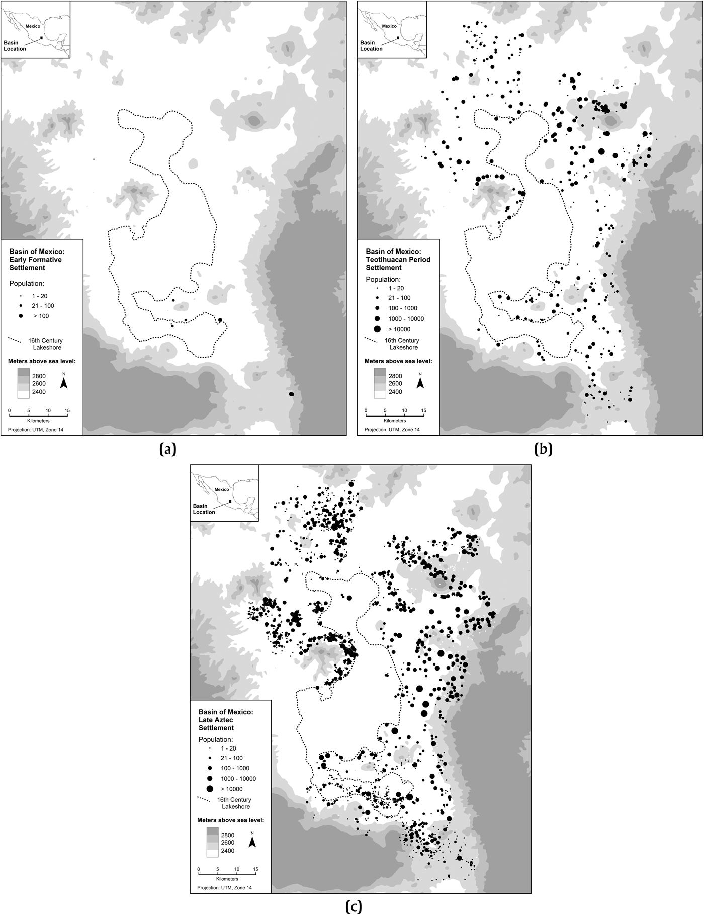
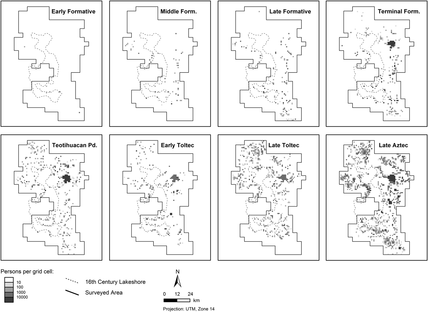
The resulting GIS database contains key information on all archaeological sites in the Basin of Mexico for eight periods of pre-Columbian occupation—Early Formative (1500–1050 b.c.), (Late) Middle Formative (900–650 b.c.), (Late) Late Formative (550–300 b.c.), (Late) Terminal Formative (100 b.c.– a.d. 150), Teotihuacan period (a.d. 150–750), Early Toltec (a.d. 750–1000), Late Toltec (a.d. 1000–1150), and Late Aztec (a.d. 1400–1519). Beyond providing the capability to develop very precise thematic maps showing the distribution of settlement and population in the region for various time periods (Figure 2), through integrating geographic space (location) explicitly into our data we introduce the potential for a number of types of analysis not possible, or at least not easily achievable, previously. I consider some of these investigations below, after first revisiting select previous analyses with these finalized data.
Archaeological settlement in the Basin of Mexico (shown as estimated populations): (a) Early Formative, (b) Teotihuacan period, (c) Late Aztec.

PRE-COLUMBIAN REGIONAL SETTLEMENT IN THE BASIN OF MEXICO
Demographics, Sites and Site Types, and Environmental Patterning
In their synthesis of Basin of Mexico settlement pattern data, Sanders, Parsons, and Santley conducted several analyses of these data to identify selected characteristics of settlement (Sanders et al. Reference Sanders, Parsons and Santley1979). Although such analyses were not necessarily spatial, in the sense of explicitly considering the geographic arrangement of settlement, they are important to our understanding of how regional organization of the basin evolved over time. Nevertheless, the data examined by Sanders and colleagues were not yet finalized—interpretations of some archaeological data were incomplete (including identification of all other occupations), adjustments were necessary to ensure consistent treatment of sites in different survey regions, and all ancillary data (for example, environmental data) had not been identified or recorded. Before considering some new issues bearing on spatial parameters of pre-Columbian regional organization in the Basin of Mexico, I revisit here some key earlier analyses.
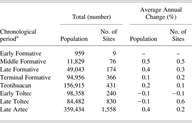
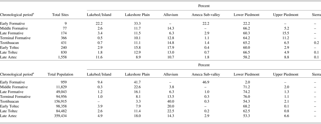
One of the most important issues that settlement pattern data address concerns regional demographics and population change over time. One gains access to such big questions through population estimates for thousands of individual sites, based on some conversion of pre-Columbian architecture (for example, domestic mounds), density of surface artifacts, or a combination of the two, into population figures. Based on survey data, population estimates for the pre-Columbian Basin of Mexico range from fewer than 1,000 people living in nine sites during the Early Formative occupation to more than 359,000 people living in nearly 1,600 sites during the Late Aztec period (Table 1). Basin population grew through the Teotihuacan period occupation and then declined during the Early Toltec and Late Toltec periods, rebounding substantially between the Late Toltec and Late Aztec occupations. As pointed out elsewhere (Gorenflo Reference Gorenflo and Storey2006), however, neither population growth nor population decline was of a magnitude that would necessarily mark some major event—say, massive in-migration from outside of the basin in the case of the former, or a surge in mortality due to widespread warfare in the case of the latter. This is not to say that such events did not happen. For example, the population decline of more than 37% following the Teotihuacan period considers a total population estimate for the Teotihuacan period and a total estimate for the Early Toltec occupation. Since more than five centuries separate the mid-points of these two time periods, there would have been ample time for population to have declined markedly and then recovered, possibly repeating such a pattern several times while introducing other types of change as well, with any major event(s) lost in the archaeological record. Increased chronological control would contribute to our understanding of how pre-Columbian demographic processes contributed to regional settlement pattern change in the Basin of Mexico, though destruction of the archaeological record by development over the past five decades precludes reexamination of many sites discovered by the settlement pattern surveys. Ultimately, researchers likely will have to turn to alternative approaches to understand pre-Columbian demography, such as the application of DNA analysis to identify the role of migration in the arrangement of regional settlement (see, for example, Mata-Míguez et al. Reference Mata-Míguez, Overholtzer, Rodríguez-Alegería, Kemp and Bolnick2012).
Rates of change over time in the Basin of Mexico: Pre-Columbian population and total sites

aMiddle Formative, Late Formative, and Terminal Formative data are for late subphases of each period.
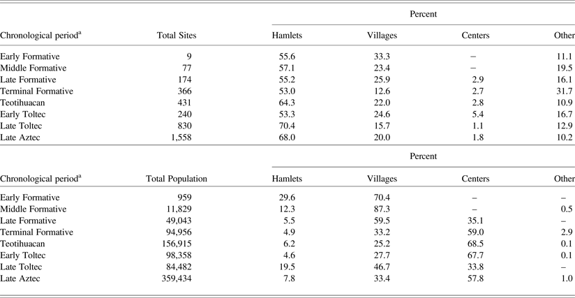
As shown in Table 1, the total number of sites in the Basin of Mexico increased throughout the region's pre-Columbian past with one exception, between the Teotihuacan and Early Toltec periods. The types of sites present in any time period, however, varied considerably. The settlement pattern surveys classified archaeological sites into more than a dozen types. For purposes of this analysis and comparison, I have collapsed these categories into four types: hamlets, villages (including barrios of centers and isolated elite districts), centers, and other—the latter including ceremonial centers, quarries, irrigation canals, and other special-function sites, as well as sites where the type was unknown. For all periods of pre-Columbian occupation in the basin, hamlets comprised the largest number of sites, followed by villages and sites in the other category (Table 2). Sites categorized as centers, based on a combination of estimated population and the presence of public architecture, do not appear until the Late Formative period, and thereafter are consistently the least frequent site type present.
Pre-Columbian settlement in the Basin of Mexico by site type

aMiddle Formative, Late Formative, and Terminal Formative data are for late subphases of each period.
In contrast to the total number of sites, the largest numbers of people in the pre-Columbian Basin of Mexico tended to live in centers (four periods of occupation) and villages (four periods, including two that featured no centers) (see Table 2). More than two-thirds of the Teotihuacan period and Early Toltec populations lived in centers, in contrast to barely one-third of the regional population during the Late Toltec occupation. In contrast, nearly 60% of the Late Formative population and almost half of the Late Toltec population lived in villages, though both of these periods also featured centers. Such differences in the allocation of population to site types likely reflect important differences in regional organization—the periods when villages were relatively more demographically important, possibly also marking occupations of dispersed settlement and less centralized political control, while periods when centers contained more population possibly indicating periods of more concentrated administration. Hamlets and sites categorized as other tend to be much less important demographically, the appearance of the latter as important during the (Late) Terminal Formative reflecting several uncategorized sites in the Cuautitlan region that almost certainly were villages (but which lack the data to support a precise classifications [see Sanders and Gorenflo Reference Sanders and Gorenflo2007]).
An important focus of the Basin of Mexico settlement pattern surveys was an emphasis on cultural ecology—exploring how the pre-Columbian residents of the basin adapted to their natural environment, and how various adaptive strategies influenced sociocultural evolution. One means of incorporating an ecological focus into the analysis of survey data was to examine the occurrence of settlement with respect to major environmental zones. Archaeologists in the Basin of Mexico divided the region into 10 environmental zones (Sanders et al. Reference Sanders, Parsons and Santley1979): lakebed, island, saline lakeshore, deep soil alluvium, thin soil alluvium, upland alluvium, lower piedmont, middle piedmont, upper piedmont, and sierra. For analytical purposes and ease of presentation, I collapse these zones into seven that would have presented similar adaptive challenges and opportunities: lakebed/island (localities within the bounds of the pre-Columbian lake), saline lakeshore, alluvium (thin and deep soil), Ameca sub-valley (upland alluvium), lower piedmont (categorized as lower and middle piedmont in some surveys), upper piedmont, and sierra. For all periods of pre-Columbian settlement except the Early Formative (which contained only nine sites, precluding the identification of any environmental patterns in the arrangement of settlement), the largest number of sites occurred in the lower piedmont (Table 3). The second most frequent location for pre-Columbian sites in the basin tends to vary between the alluvium and lakeshore plain, with the sierra becoming important in the Late and Terminal Formative and lakebed/island locations becoming important during the Late Aztec occupation.
Pre-Columbian settlement in the Basin of Mexico by environmental zone

aMiddle Formative, Late Formative, and Terminal Formative data are for late sub-phases of each period.
Excluding the Early Formative once again due to the small number of sites, the lower piedmont contained the largest pre-Columbian populations in the Basin of Mexico as well (see Table 3). Alluvium and lakeshore plain usually accounted for the second largest amounts of population in each period of pre-Columbian occupation, followed by smaller numbers of people in the remaining four environmental zones. Much of the importance of the alluvium in the Teotihuacan period, and to a lesser extent in the Terminal Formative, Early and Late Toltec, and Late Aztec periods, is due to the sprawling settlement of Teotihuacan. Although the spatial extent of Teotihuacan was less before and after the Teotihuacan period (Garraty Reference Garraty2006; Gorenflo and Sanders Reference Gorenflo and Sanders2007; Nichols Reference Nichols2013; Robertson Reference Robertson2007), large areas of occupation occurred, in part, in the lower piedmont and, in part, in the deep soil alluvium. The recurring importance of the lower piedmont and, to a lesser extent, thin and (especially) deep soil alluvium, likely reflects the advantages that these zones offered to preindustrial agriculture, the combination of soil qualities, microclimate, and topography providing favorable conditions for growing maize and the other cultigens that formed the basis of the pre-Columbian basin economy. Occupations in other environmental zones, in turn, may indicate the importance of other resources and economic activities at various times in the pre-Columbian basin—for instance, the nearly 23% of Late Aztec population living within the bounds of the ancient lake system and on the lakeshore plain likely indicates the importance of a variety of lacustrine resources, including salt as well as various plants and animals (see Parsons Reference Parsons2006).
The settlement pattern database for the Basin of Mexico provides an opportunity to revisit some previous analyses conducted more than three decades ago with data that had not yet been finalized. It also provides an opportunity to examine shifts in the distribution of site sizes (populations) over time. Results indicate a slowly changing population over time, with some more dramatic changes in the allocation of people among various site types—the latter indicating important shifts in the political and economic organization of the basin. Regional settlement, with respect to the natural environment, similarly indicates a consistency over time, the persisting dominance of the lower piedmont modified with changing levels of importance of other environmental zones that may indicate modifications in economic activity, changes in sociopolitical organization, or some combination of the two. I turn to explore how these basic insights can benefit from complementary investigations using other perspectives.
The Arrangement of Regional Settlement in Geographic Space
The creation of a GIS database for pre-Columbian settlement in the Basin of Mexico introduces the possibility of integrating geographic space into our understanding of the evolution of regional demographics and sociocultural systems in this region. Two possible categories of initial analysis emerge: the relationship of settlements with respect to one another, and the relationship of settlements with respect to important environmental variables or characteristics. The range of potential inquiries is quite broad, well beyond that possible in this single paper. But one can provide a sense of the types of studies possible with the data available, the insights they provide on sociocultural evolution in the Basin of Mexico, and additional work needed to further our understanding of the role played by regional organization.
Let us begin with some simple mapping, to provide a better sense of the distribution of pre-Columbian population in the basin over time. The maps shown in Figure 2 are one approach to this task, with the presentation of settlements using symbols proportional to the population of each showing how this variable was arranged in geographic space. An alternative approach is to reflect population variation in the shading of grid cells, here 1 × 1 km in size (Figure 3). These maps follow an earlier effort to map population by 4-km square grid cell (Gorenflo Reference Gorenflo and Storey2006), the finer resolution here providing a better sense of regional demographics over time. Showing population in a grid portrays the spatial distribution of this variable across commensurate units—enabling one to examine the geographic arrangement of population in the pre-Columbian Basin of Mexico and how this arrangement evolved over time. Moreover, because the grid consists of 1 km2 cells, this map presents population density, as persons/km2, for the region as well.
Pre-Columbian population in the Basin of Mexico (shown as 1-km square grid cells).

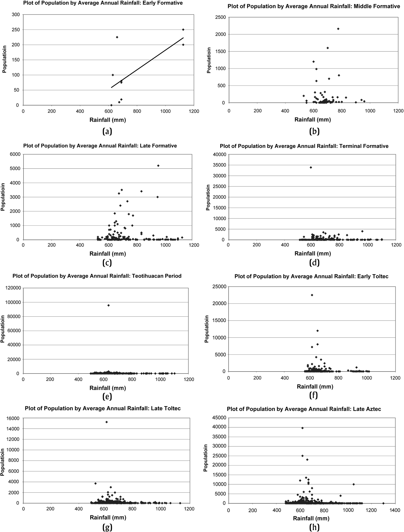
Archaeologists contend that intensive agriculture provided the economic foundation for the pre-Columbian inhabitants of the region, certainly after the Middle Formative period of occupation (Sanders et al. Reference Sanders, Parsons and Santley1979). In a region such as the Basin of Mexico, particular variables would have had an important influence on agriculture, including soil, topography, and climate (especially rainfall and microclimatic effects, such as frost). We can consider rainfall as an environmental characteristic that varied over space and that could have greatly influenced the placement of settlements in a society reliant on intensive agriculture. Through creation of a database with geographic coordinates, each site can be associated with an average annual rainfall value that provides a basis for examining the relationship between population and this essential environmental variable. Despite its potential role in crop production, rainfall appears to have had limited influence on settlement at any time in the basin with the possible exception of the Early Formative period, though once again it is difficult to identify any relationship with only nine sites (Figure 4). Middle and Late Formative settlement show a slight relationship between population and rainfall; the remaining periods show very little relationship between these two variables. Indeed, after the Late Formative period many of the largest sites in the region occur in localities receiving between 500 and 700 mm of rainfall annually, a very low amount to support maize agriculture. Research by Nichols (Reference Nichols1980, Reference Nichols1987) in the Cuautitlan region showed how risky rainfall-based agriculture could be due to annual variation in amount and timing of rain, and hence the potential importance of irrigation in that portion of the basin. Sanders (Reference Sanders1965; see also Sanders et al. Reference Sanders, Parsons and Santley1979) has argued that Teotihuacan's emergence, and especially the concentration of population in Teotihuacan during the Early Terminal Formative (250–100 b.c.) and the Late Terminal Formative periods, was largely irrigation-dependent. The presence of a slight relationship between population and rainfall in the Early, Middle, and Late Formative may indicate a reliance on rain-fed agriculture until irrigation became more widespread and accessible, with the emergence of more complex societies in the Terminal Formative and later. The general lack of association between rainfall and population throughout much of the basin's pre-Columbian occupation may indicate a broader reliance on irrigation than previously believed, with the likelihood that most larger settlements relied heavily on some form of irrigation to supplement meager amounts of rainfall—particularly, though not exclusively, in the more arid northern parts of the region.
Scatter plots of pre-Columbian population and average annual rainfall in the Basin of Mexico: (a) Early Formative, (b) (Late) Middle Formative, (c) (Late) Late Formative, (d) (Late) Terminal Formative, (e) Teotihuacan period, (f) Early Toltec, (g) Late Toltec, (h) Late Aztec.

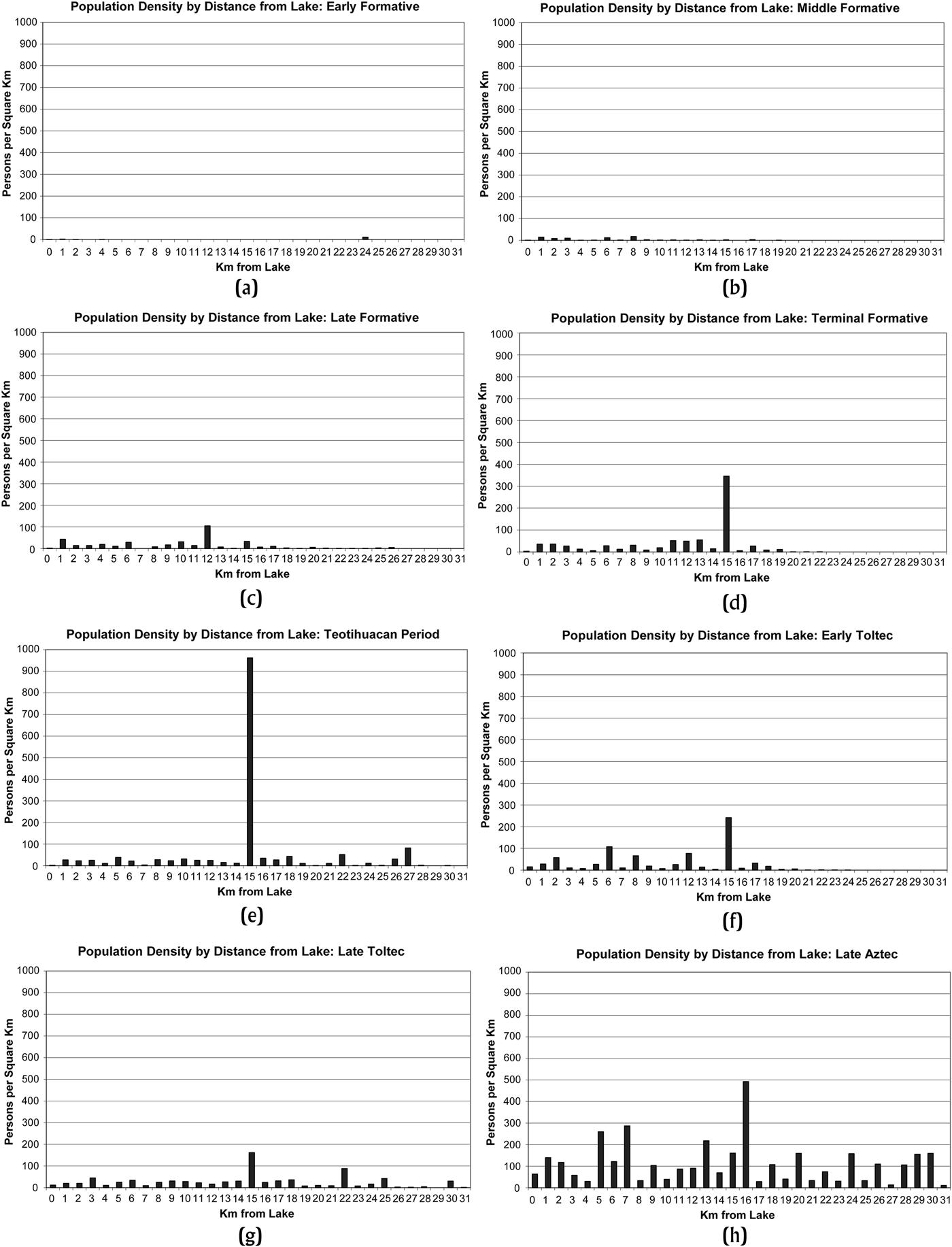
One of the most noteworthy features of Basin of Mexico physical geography was the system of shallow lakes in the center of the region. Ethnohistoric and ethnographic data indicate that the lake system played an important role in the region's economy (Gibson Reference Gibson1964; Parsons Reference Parsons2006), while other research proposes that the lake system would have been essential to the transportation of food and other bulky materials in the basin in the absence of beasts of burden (Gorenflo and Gale Reference Gorenflo and Gale1990; Hassig Reference Hassig1985; Sanders and Santley Reference Sanders, Santley, Vogt and Leventhal1983). One means of assessing the importance of this feature to regional organization is to examine the arrangement of sites in terms of proximity to the lakeshore. Although lakeshore proximity is not absolutely essential in indicating how important the lakes were in regional settlement, a tendency for population to concentrate near the lakes would support the contention that they were an important component of regional organization (Gorenflo and Garraty Reference Gorenflo, Garraty, Nichols and Rodríguez-Alegría2016). Examining the occurrence of sites in 1-km strips, or buffers, around the likely sixteenth century lakeshore (defined by the 2,238 m contour; see Sanders et al. Reference Sanders, Parsons and Santley1979) indicates some inclination to place settlements within the bounds of the lakes or nearby, beginning in Early Formative period and continuing throughout the region's pre-Columbian occupation (Figure 5). Nevertheless, this tendency is not particularly strong and tends to be less so from the Terminal Formative period onward—though larger numbers of people lived within the bounds of the lakes or near the lakeshore in later periods of occupation. Settlement densities within the 1 km-wide buffers tend to be modest near the lakes, only twice exceeding 35 persons/km2 until the Late Aztec period, when the 1 km-wide strip adjacent to the lakeshore reached 139 persons/km2 and the strip 1–2 km from the lakeshore reached 117 persons/km2. These striking differences in population density contrast with the percentage of total population living near the lakeshore, which was minimally twice as high during the Early through Late Formative occupations as during the Late Aztec period. Lake-oriented adaptation during the Formative occupations in the basin have received relatively little attention compared to their Late Aztec counterpart, though in relative terms they may indicate considerable importance of lake proximity.
Estimated pre-Columbian population density by distance from the pre-Columbian lakeshore in the Basin of Mexico: (a) Early Formative, (b) (Late) Middle Formative, (c) (Late) Late Formative, (d) (Late) Terminal Formative, (e) Teotihuacan period, (f) Early Toltec, (g) Late Toltec, (h) Late Aztec.

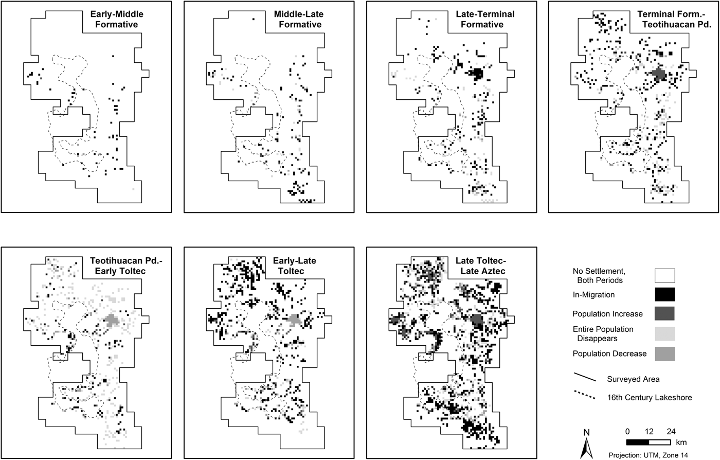
To close this brief examination of the Basin of Mexico settlement patterns using the GIS database, let us consider possible mechanisms underlying the changing arrangement of people throughout the region's pre-Columbian past. Examining the gridded population distributions presented in Figure 3 indicates considerable changes in regional settlement over time. Beyond the previously documented shift in emphasis from the southern Basin of Mexico during the early occupations to the north by the Terminal Formative period, by comparing grids one finds evidence for considerable movement throughout the region from one period of settlement to another (Figure 6). Here I consider two different indicators of mobility: grid cells unoccupied in one period that were occupied in a succeeding period, where the only explanation is migration from elsewhere (see Gorenflo Reference Gorenflo and Storey2006); and grid cells occupied in one period that were unoccupied in a succeeding period, possibly indicating that a resident population died out but more likely abandonment of one location for another. Two other indicators of change, when the population in a particular grid cell increased or decreased from one period to the succeeding period, also may indicate mobility or natural population increase or decrease associated with changing balance between mortality and fertility. A preliminary analysis of pre-Columbian population estimates for the basin using 4-km square grid cells indicated considerable movement between major periods of occupation (Gorenflo Reference Gorenflo and Storey2006). This higher resolution analysis indicates even greater occurrence of movement, in addition to other reasons for geographic shifts in settlement, across much of the region—with well-known instances of migration, such as apparent movement into Teotihuacan between Late and Terminal Formative occupations and increasing settlement of the basin between the Terminal Formative and Teotihuacan period augmented with evidence of local shifts and other apparent patterns throughout the region. Analyses of correlations between succeeding periods for grid cells that registered at least one populated site (thereby indicating a potential for occupation) revealed relatively few significant results and generally quite low correlation measures, suggesting that the pattern of occupation in one period had limited effect on the pattern in the succeeding period (Table 4). The reasons for such widespread mobility remain unknown, but the frequency with which it occurred indicates a fundamental process in basin settlement that deserves further attention.
Pre-Columbian population change in the Basin of Mexico between successive periods of occupation (shown as 1-km square grid cells).

Correlations of gridded population in one period of occupation with that in the preceding period

aSignificance at .01
The above analyses of the GIS settlement database for the Basin of Mexico represent a preliminary set of inquiries on the regional arrangement of population, how this arrangement changed over time, and possible reasons for these changes. We see evidence for a remarkably mobile population whose geographic arrangement at any point in time represents the results of people moving from other localities in the basin or beyond, and people moving to other localities inside or beyond the region as well. Reasons for frequent movement—acknowledging that we are looking at several centuries of human occupation here—remain uncertain, though given the central role of agriculture in the pre-Columbian economy of the basin soil management or other related considerations may have played an important role. Despite this tendency for geographic adjustment, rainfall apparently had surprisingly little effect on where people lived, particularly in the case of larger sites—in all likelihood indicating that the residents of the Basin of Mexico in many cases could compensate for lack of adequate rainfall with irrigation. Orientation toward the central lake system, an important source of resources and an important means of transporting resources over longer distances, varied considerably between periods, larger percentages of the regional population living within the bounds of the lakes or nearby earlier in the pre-Columbian sequence and higher densities living within or near the lakes later in the sequence. These shifts may indicate changes in regional economies, changes in local adaptation, or some combination of the two with respect to placement of settlement near the lakes.
IN SEARCH OF FURTHER UNDERSTANDING: DATA SHORTCOMINGS AND NEXT STEPS
Research on pre-Columbian regional settlement patterns in the Basin of Mexico has come a long way since those early days of the Teotihuacan Valley survey in 1960. In addition to having compiled data on more than 3,900 separate archaeological sites in the basin, basic analyses provide insights on how settlement patterns in the region evolved over time and space. But there is much work to be done. Some of this additional effort concerns further enhancements of existing datasets and the analyses possible with them. Other efforts concern research yet to be conducted, including that on the natural environment. Finally, we face inherent limitations of regional analysis of archaeological data, and these limitations need to be acknowledged and compensated for, when possible.
The biggest enhancement of existing GIS data involves the development of polygon GIS data for all known archaeological sites. With few exceptions—primarily the sites located within the bounds of urban Teotihuacan for various time periods—sites analyzed in the research presented here have been point data, representing the geographic centroids of all known sites in the Basin of Mexico. For small sites, covering a limited geographic area, the analytical discrepancy between point data and polygon data is similarly small. For larger sites, more precise boundaries showing the geographic shape of each site is important. For instance, in measuring the distance of sites to the lakeshore, portions of each site will be closer than its centroid, altering the results of analyses of proximity to this important geographic feature. In the search for broad patterns in regional settlement pattern data, polygon data will not substantially change any of the results presented here. Nevertheless, in the interest of conducting the most precise analyses possible, augmenting existing information with polygons for each site is important. Precise boundaries exist for all known archaeological sites in the basin, mapped by hand in the process of compiling settlement pattern data. Recent efforts led by Kenneth Hirth for the data collected by Parsons and Blanton have produced polygon data for a large part of the basin—those five regions surveyed by University of Michigan projects. Ongoing efforts for the data collected on surveys directed by Sanders will provide similar data for the remainder of the basin in the next year.
One of the most deficient pieces of information on regional settlement in the Basin of Mexico concerns data on the natural environment to which past societies adapted. A central component of the cultural ecological research that has dominated settlement surveys and analyses, our understanding of the natural environment, is based on a setting—the modern basin—greatly altered through pre-Columbian, historic, and modern activity. Nichols (Reference Nichols1980, Reference Nichols1987) identified the presence of considerable erosion from the piedmont into the alluvial plain below as early as the Late Middle Formative period, indicating the early emergence of substantial human impacts on the natural environment that more recent research has supported (Cordova Reference Córdova1997; Cordova and Parsons Reference Córdova and Parsons1997; Frederick Reference Frederick1997; Frederick et al. Reference Frederick, Winsborough, Popper and Brumfiel2005). Propositions of change during pre-Columbian occupations in the natural setting, and the presence of complex interactions between human land use and natural processes, are well-documented historically in the general region. Working in the Mezquital drainage north of the Basin of Mexico, Melville (Reference Melville1994) documented a number of dramatic environmental changes that accompanied Spanish colonial settlement and land use, including enormous amounts of erosion associated with herding sheep and the associated deterioration of Aztec terrace systems. Broad expanses of Colonial period erosion in the basin have been discussed previously (Cook Reference Cook1949), providing further evidence of a need to explore this problem. Ultimately, what we have examined in the Basin of Mexico is pre-Columbian adaptation to a natural environment defined in large part on modern conditions. Certain characteristics important to the inhabitants of the region likely remained unchanged—for instance, frost patterns and topography. But others, such as soil depth and quality, vegetation, hydrology, and key aspects of the climate, have changed considerably between the various periods of pre-Columbian occupation and the mid-twentieth century and probably within the pre-Columbian period as well (see McClung de Tapia Reference McClung de Tapia, Cooper and Sheets2012; McClung de Tapia and Adriano-Morán Reference McClung de Tapia and Adriano-Morán2012; McClung de Tapia and Martínez Yrizar Reference McClung de Tapia, Martínez Yrizar and Brumfiel2005; McClung de Tapia et al. Reference McClung de Tapia, Solleiro-Rebolledo, Gama-Castro, Villalpando and Sedov2003; Morehart and Frederick Reference Morehart and Frederick2014). We need to reexamine these characteristics of the natural environment to define its configuration in the past, to provide a more accurate picture of possibilities and constraints that basin biogeography posed at the time of pre-Columbian occupations. One approach is through efforts to document the paleoenvironment, such as studies conducted by McClung de Tapia (for example, McClung de Tapia and Adriano-Morán Reference McClung de Tapia and Adriano-Morán2012; McClung de Tapia and Sugiura Reference McClung de Tapia and Sugiura1999). Much of the effort might be focused on assembling key information from studies already conducted. Recent research, including that in the Teotihuacan Valley (McClung de Tapia et al. Reference McClung de Tapia, Solleiro-Rebolledo, Gama-Castro, Villalpando and Sedov2003, Reference McClung de Tapia, Villalpando, Solleiro, Gama, Benavides, Manzanilla and Mirambell2004, Reference McClung de Tapia, Domínguez-Rubio, Gama-Castro, Solleiro and Sedov2005), however, indicates that in many cases changes appear to have been localized—suggesting that understanding regional patterns of ecological adaptation will require considerable effort to control local paleoenvironmental conditions.
A main problem in analyzing archaeological settlement patterns is the equation of resulting data with pre-Columbian settlement systems. Archaeologists often treat settlement pattern data as snapshots of regional organization, and the patterns of sites, site sizes and types, regional demographics, and so on as representing coeval data (see, for example, Gorenflo Reference Gorenflo, Mastache, Parsons, Santley and Puche1996). This is, of course, both incorrect and obviously an oversimplification to anyone interested in the analysis of pre-Columbian regional settlement. The challenge is how to deal with this problem. Some have argued for analytical solutions (see Dewar Reference Dewar1991; Kintigh Reference Kintigh1994), incorporating length of time period and related considerations to address the issue of contemporaneity. Other solutions may relate to further refinement of chronology, both for the Basin of Mexico as a whole (see Cowgill Reference Cowgill1996; Parsons et al. Reference Parsons, Brumfiel and Hodge1996) and for individual sites, though in truth the potential of reanalyzing artifact collections for surveyed sites, where collections exist, will be limited given the non-systematic nature of the collections themselves. Ultimately neither solution will address the fundamental problem of determining which sites were occupied at a given time, and the number of people likely living in each—both questions frequently associated with regional survey data and important liabilities in any attempt to understand pre-Columbian regional organization.
A final problem, and something that one must live with in analyzing pre-Columbian settlement patterns in the Basin of Mexico, is incomplete regional coverage. Sanders and Parsons lamented about this shortcoming for years, with the latter writing (Parsons Reference Parsons2015) that had they known the sprawl from Mexico City would have been so rapid and at such a large scale they would have begun their surveys in the southwestern basin. As shown in Figure 1, although the largest portion of the basin not surveyed is indeed in the southwest—the area covered by Mexico City and related settlement—other small uncovered sections exist as well, mainly in the north (between the Temascalapa and Zumpango regions) and in the east (between the three sections of the Texcoco survey region). The area in the southwest is particularly concerning, with lack of data undermining our understanding both for the Terminal Formative period and the role of Cuicuilco as a major competitor with Teotihuacan for regional dominance (see Sanders et al. Reference Sanders, Parsons and Santley1979), and for the Late Aztec settlement system with its geographic base at Tenochtitlan in the unsurveyed area. Salvage archaeology has provided some clues to pre-Columbian settlement in this area, as have ethnohistoric data for Tenochtitlan and surrounding environs (see, for example, Calnek Reference Calnek and Wolf1976, Reference Calnek, Evans and Webster2001). Nevertheless, these substantial gaps in data pose major problems, and will continue to compromise our understanding of Basin of Mexico settlement and regional organization.
Solutions to the above shortcomings are not simple, but they are in some cases possible. Efforts to define each site as a polygon in a GIS database currently are underway with data that already exist. Reconstructing the paleoenvironment, although challenging and requiring a serious commitment of time and resources, similarly is occurring; improving our understanding of the past environment in the basin appears to be possible with existing data, though further research will be needed to generate a working understanding of this critical issue. Improving chronological control of regional data ultimately is limited by the nature of those data, but some improvement may be possible. Mining data on the salvage archaeology in Mexico City, as Bill Sanders was in the process of completing when he died, can help to fill in small parts of that substantial data gap, though other portions of the basin not surveyed likely will remain unknown because of modern impacts on the archaeological record. Of course, one of the greatest contributions to understanding regional settlement in the Basin of Mexico would be through more primary research, particularly excavation of selected sites to improve both chronological control and our understanding of site function in a regional context. Unfortunately, due to growing human population in the basin and increasingly destructive agricultural practices over the past five decades, many sites that might have been of interest for excavation no longer exist. For sites that do persist, settlement data could be used to select those whose excavation would address one or more of the shortcomings in our current understanding of sociocultural evolution in this important region. When excavation is not immediately possible at a remaining important site, steps should be taken to conserve that site to make it available for further inquiries in the future.
CONCLUSIONS
Research on the regional patterning of pre-Columbian settlement in the Basin of Mexico has evolved from early, tentative steps to a basin-wide dataset that covers virtually the entire region that could be surveyed prior to 1975. Although there has been considerable delay in generating the final settlement pattern database for the entire region, we have benefited greatly from the increases in technology and analytical methods that have enabled us to improve both the presentation of these data and their investigation. One group of methods that have greatly improved over the past two decades are those related to GIS technology. It is important to see GIS for what it is—not some magical source of insight to past regional organization, but rather a collection of tools for storing, manipulating, analyzing, and presenting data that requires researchers to identify pertinent questions of the data available. Nevertheless, GIS technology provides enormous potential for the analysis of settlement pattern data in the Basin of Mexico, enabling researchers to address a variety of questions through exploratory geospatial analysis that will improve our understanding of sociocultural evolution in this region.
Regional settlement in the Basin of Mexico evolved in fascinating ways over three millennia of pre-Columbian occupation. Based on settlement survey data, population changed slowly. Despite these slow rates of change, major shifts occurred in the types of settlements present and the arrangement of settlements with respect to environmental zones, both likely indicating important sociocultural changes accompanying, or accompanied by, shifts in settlement type and location. Moreover, with few exceptions, residents of the Basin of Mexico did not identify favorable locations that persisted over time. Rather, they shifted their locations from period to period of pre-Columbian occupation. These shifts occurred with surprisingly little regard to rainfall in the case of many larger sites, indicating a reliance on water control that was more geographically widespread than previously imagined. Settlement with respect to the most dominant physical geographic feature of the basin, the central lake system, varied over time as well, with changes in proximity measured in relative and absolute terms likely indicating shifts in importance of lacustrine proximity currently not well understood.
One of the great unrealized potentials for regional settlement data from the Basin of Mexico is to guide future research, something the researchers who led surveys of the region always envisioned. In the simplest form, this might occur as identifying sites in particular categories—for example, certain site types or sites in particular locations—for further investigation. In its more complex form, this might occur as identifying sites whose study could answer key questions that emerge from the study of settlement patterns—such as sites that occur in natural settings that could not easily support the population they apparently contained. The clear problem in guiding future research is that many of the most important potential candidates for such inquiries no longer exist, or have been adversely affected such that their study would yield, at best, limited insights. Even personal experience tells a grim tale here: Tepetlaoztoc, a Late Aztec site in the Texcoco region with remarkably detailed ethnohistoric documentation, found to be virtually destroyed by eucalyptus reforestation when Sanders and I visited it in the mid–1990s (Sanders Reference Sanders and Sabloff1996); TM-Cl-38, a Teotihuacan Period site in a particularly remote portion of the Temascalapa region, destroyed by a golf course; the virtual eradication of archaeological remains in the Cuautitlan region due to sprawling settlement from Mexico City during the 1970s–1990s (see Sanders and Gorenflo Reference Sanders and Gorenflo2007); and the loss of key sites throughout the basin, revealed through a reconnaissance by Jeff Parsons and myself in 2008 and 2009 (currently being augmented by more recent data and written up). Nevertheless, the possibility certainly exists that key archaeological remains from an inventory that numbered more than 3,900 individual sites have persisted despite the pressures of modern development. The challenge that faces us is to appreciate how such settlements fit into the regional organization of the Basin of Mexico over time, and to identify clues in what remains to help understand the evolution of pre-Columbian complex societies in the basin as a whole.
RESUMEN
Uno de los componentes más importantes de la investigación arqueológica en la cuenca de México ha sido una serie de recorridos de superficie regionales llevados a cabo entre 1960 y 1975. Este artículo discute los esfuerzos para completar los datos de los asentamientos generados por esos recorridos y resumir los análisis preliminares de la base de datos resultante que incluye aplicaciones de sistemas de información geográfica para examinar los patrones de asentamiento a través del tiempo. El trabajo inicia revisando brevemente los recorridos de las siete regiones de la cuenca, iniciando con el reconocimiento de superficie de la región de Teotihuacan hecho entre 1960 y 1965 bajo la dirección de William Sanders. Los recorridos subsecuentes, dirigidos por Sanders, Jeffrey Parsons y Richard Blanton generaron información de más de 3,900 sitios arqueológicos precolombinos, fechados para periodos de tiempo que van desde el periodo formativo temprano (1500–1050 a.C.) al Azteca tardío (1400–1519 d.C.). Cubriendo la mayor parte de la cuenca de México, con la excepción principal de la porción suroeste de la región obscurecida por los asentamientos modernos de la ciudad de México, estos datos proporcionan una imagen extraordinariamente detallada de esta importante región.
El análisis de los datos demográficos revela generalmente un incremento y disminución poblacional lentos que no indican eventos demográficos importantes. Sin embargo, la falta de controles cronológicos más estrechos puede obscurecer instancias más dramáticas de crecimiento o descenso poblacional que no pueden ser detectados en los datos del asentamiento regional a partir de como está definido actualmente. Los recorridos identificaron varios tipos de sitios, que para los propósitos actuales se resumen en cuatro grupos: aldeas, pueblos, centros y otros (por ejemplo, centros ceremoniales, yacimientos, canales de irrigación, y otros sitios de funciones especiales, así como sitios en los que sus tipos son desconocidos). Para todos los periodos de tiempo, las aldeas son el tipo de sitio encontrado más frecuentemente. En contraste, en los periodos de tiempo en los que hubo centros, éstos contienen frecuentemente la mayor parte de la gente, con la excepción del periodo formativo tardío (tardío) (550–300 a.C.) y el periodo Tolteca tardío (1000–1150 d.C.) cuando los pueblos albergaban grandes poblaciones, marcando muy probablemente periodos cuando la organización regional no estaba tan estrechamente controlada por la administración central de la región. Este estudio también examina los asentamientos de acuerdo a su zona medioambiental a partir de las siguientes categorías: lecho del lago/isla (localidades dentro de los límites del lago precolombino), orilla salina del lago, aluvión (suelo delgado y profundo), sub-valle de Ameca (aluvión de montaña), piamonte bajo (categorizado como piamonte bajo y medio en algunos recorridos), piamonte alto y sierra. El piamonte bajo tendió a contener tanto el mayor número de sitios como las poblaciones más grandes, consistentes con las ventajas que proporciona esta zona ambiental para la agricultura precolombina del maíz.
Organizar los datos de asentamiento de la cuenca de México en un sistema de información geográfica permite el análisis de varias cuestiones asociadas con el papel del espacio geográfico en la organización regional. Al examinar la incidencia de los sitios arqueológicos con respecto al promedio anual de precipitación se observa una asociación limitada entre estas variables a través del periodo formativo tardío (tardío) y una asociación aún menor en el resto de los asentamientos de los otros periodos precolombinos. La aparición de grandes poblaciones en zonas de baja precipitación sugiere que la irrigación pudo haber jugado un papel más importante a través de la cuenca de lo que anteriormente se pensaba. El análisis de los asentamientos con respecto a la proximidad del sistema del lago que dominaron la porción central de la cuenca de México precolombina revela una tendencia a establecerse cerca de la orilla del lago. La influencia del sistema del lago en los asentamientos es particularmente aparente durante el periodo formativo temprano-tardío (tardío) (como se mide en términos de porcentaje poblacional en la cuenca). Trazando la población en mapas con una retícula de cuadros de 1 km proporciona una imagen más clara del arreglo geográfico de la población regional a través del tiempo. También indica el grado en que la ubicación de la gente cambió con el tiempo, en muchos casos moviéndose hacia emplazamientos donde no habían vivido en periodos de tiempo anteriores, en otros casos probablemente abandonando localidades que fueron ocupadas anteriormente.
Persisten ciertas deficiencias claves en los datos de asentamiento de la cuenca de México que limitan nuestro entendimiento respecto al cambio de la organización espacial en esta importante región. Algunas de esas deficiencias pueden abordarse. Se están realizando esfuerzos para representar todos los asentamientos precolombinos como polígonos, en vez de puntos, permitiendo así análisis más precisos de los patrones espaciales. Además existen datos para mejorar nuestra comprensión del medioambiente precolombino de la cuenca y de como cambió este medioambiente a través del tiempo, lo cual proporcionará un importante entendimiento de la ecología cultural de la organización de asentamientos a escala regional. Hay otros problemas inherentes en el análisis de los datos de asentamientos arqueológicos, en particular el desarrollo de una imagen clara de asentamientos contemporáneos en ausencia de un mejor control cronológico. Sin embargo, los análisis de esta extremadamente rica base de datos proporcionan importantes ideas respecto al asentamiento regional precolombino y a como la disposición del asentamiento pudo haber afectado, o ha sido afectado, por las sociedades complejas desarrolladas en esta porción clave de mesoamérica.
ACKNOWLEDGMENTS
This paper greatly benefited from discussions with those who attended the seminar on Basin of Mexico archaeology at San Miguel Ometusco in September, 2007. Jeff Parsons and Ian Robertson read an earlier draft of this paper and provided several useful comments, augmenting the considerable advances in my own understanding of the pre-Columbian basin generated by years of collaboration with both. It is difficult to express in words the debt I owe to Bill Sanders, a teacher, collaborator, and friend for more than three decades before his passing. Although Bill and I did not always agree on Basin of Mexico settlement, his positions always made me think more about my own, and search a bit harder to make sense of the pre-Columbian occupation of the region that he explored with an unparalleled passion for more than 50 years. Oralia Cabrera Cortés kindly translated an expanded summary into Spanish.