Introduction
The booming global human population and food demand have driven deforestation for commodity expansion in many tropical and subtropical areas (Maxwell et al. Reference Maxwell, Fuller, Brooks and Watson2016, Curtis et al. Reference Curtis, Slay, Harris, Tyukavina and Hansen2018). In South America, agricultural frontiers have been expanding (De Sy et al. Reference De Sy, Herold, Achard, Beuchle, Clevers, Lindquist and Verchot2015, Fehlenberg et al. Reference Fehlenberg, Baumann, Gasparri, Piquer-Rodriguez, Gavier-Pizarro and Kuemmerle2017, le Polain de Waroux et al. Reference le Polain de Waroux, Baumann, Gasparri, Gavier-Pizarro, Godar and Kuemmerle2018) in the moist forest of Amazonia, and in deciduous and dry forest and savannahs in the Cerrado and Chaco regions (Aide et al. Reference Aide, Clark, Grau, Levy, Carr, Redo and Andrade2013). The Dry Chaco includes one of the largest continuous areas of subtropical dry forest (Portillo-Quintero & Sanchez-Azofeifa Reference Portillo-Quintero and Sánchez-Azofeifa2010), and it is among the most globally active deforestation frontiers (Hansen et al. Reference Hansen, Potapov, Moore, Hancher, Turubanova and Tyukavina2013) driven by mechanized soybean cropping and intensive cattle ranching (Gasparri et al. Reference Gasparri, Grau and Angonese2013, Baumann et al. Reference Baumann, Gasparri, Piquer-Rodríguez, Gavier Pizarro, Griffiths and Hostert2017, Fehlenberg et al. Reference Fehlenberg, Baumann, Gasparri, Piquer-Rodriguez, Gavier-Pizarro and Kuemmerle2017) (for a more in-depth description of the study region, see Supplementary Annex A1 & Fig. S1, available online).
In response to the accelerated deforestation process in northern Argentina, a national law, locally named the ‘Argentine Native Forest Law’ (hereafter NFL; Table S1; National Law number 26 331) was passed in 2007. This law aims to enhance and protect the ecological and cultural values of native forests for society (Seghezzo et al. Reference Seghezzo, Volante, Paruelo, Somma, Buliubasich and Rodríguez2011). It includes a general forest classification schema, as well as a request for the subnational political units (provinces) to assign and implement forest zonation based on the conservation value and productivity potential of dry forests at a regional level (Volante et al. Reference Volante, Mosciaro, Gavier-Pizarro and Paruelo2016). The NFL land zonation recognizes three categories of forest: (1) ‘green areas’, where productive activities are allowed due to their perceived low conservation value and high agriculture potential; (2) ‘yellow areas’, which include forests of intermediate conservation value where sustainable productive activities, such as silvopastoral systems, forest restoration programmes, tourism, gathering of forest resources and scientific research, can occur (Table S1) (Aguiar et al. Reference Aguiar, Mastrangelo, García Collazo, Camba Sans, Mosso and Ciuffoli2018); and (3) ‘red areas’, where all economic activity is prohibited due to the perceived high conservation value of forests. Additionally, the NFL offers economic subsidies to landowners for conserving forests, pending presentation and approval of sustainable management or conservation plans (Table S1). To qualify for the financial support, provinces are responsible for defining the particular requirements for those plans (Volante et al. Reference Volante, Mosciaro, Gavier-Pizarro and Paruelo2016), which typically include legal-land tenure, the delimitation of property and the demonstration of current land use (infrastructure is generally used as proof of use). In practice, provincial authorities often finance the erection of fences and the clearing of cut-fire trails as part of the activities proposed in the management plans, to prevent forest fires and to secure adequate management of the livestock within the enclosure, while simultaneously excluding livestock from outside the property (e.g., necessary for plans including restoration targets) (for a more in-depth description of the NFL and its implementation, see Annex A2).
In the Dry Chaco, the presence of large forested areas under diverse land-tenure situations, but without a physical definition of the limits, is very common. However, land-market speculation associated with the accelerated expansion of agriculture (le Polain de Waroux et al. Reference le Polain de Waroux, Baumann, Gasparri, Gavier-Pizarro, Godar and Kuemmerle2018) has contributed to reinforcing private control over the land. The privatization of land often implies erecting wire fences, frequently accompanied by removing a strip of the forest of variable width (12–50 m, depending on the legal requirements of each province). These deforested strips are locally called deslindes or picadas cortafuego (i.e., cut-fire trails) and serve both to limit fire spread and as internal roads (Fig. S2).
In the frame of the NFL, the concept of ‘sustainable land use’ is quite ambiguous and allows for divergences among the provinces’ criteria. In addition, the diversity of social actors in some sectors of the Dry Chaco further contributes to the multiple interpretations of this concept (Marinaro et al. Reference Marinaro, Grau, Gasparri, Kuemmerle and Baumann2017). Peasants (i.e., criollos or puesteros) and indigenous communities are the main local people in the region. Their livelihoods are strongly dependent on forests, which are commonly used as a common-pool resource for gathering, forage, bushmeat and fuelwood, and they contribute to cultural identity (Altricher & Basurto 2008, García-Collazo et al. Reference García-Collazo, Panizza and Paruelo2013, Dawson & Martin Reference Dawson and Martin2015). Historically, access to forest resources has been relatively unrestricted, although during the last three decades this has been increasingly restricted, largely due to the erection of fences and also to agricultural activities. In this context, it is noticeable that, of the plans approved and supported at the federal level by the NFL during 2010–2017, 88% corresponded to private owners and companies and only 2% to indigenous communities and peasants (SAyDS 2018) (for a more in-depth description of the social actors and historical land-use changes, see Annex A3).
The concepts of access and property need to be understood: access is the ability to benefit from goods and services provided by ecosystems (in this case, forests), while property recognizes the rights, whether legal or social, over the land (Ribot & Peluso Reference Ribot and Peluso2003). In the Dry Chaco, while property generally belongs to one person (although there are communal forms of property), often access is harnessed by someone else. However, the erection of fences represents the physical expression of the right over resources belonging to one person/company, while restricting the access of others. Thus, fencing is an early sign that local access to forest ecosystem services has become more limited in order to satisfy distant, often international, markets and demands (e.g., production of commodities such as soybean and beef or carbon stock for climate change mitigation). Examples of provisioning ecosystem services that are locally restricted include the access of livestock for grazing, firewood, hunting and gathering of fruits and honey and the collecting of fibres of chaguar (Bromelia hieronymi and Bromelia urbaniana) and ‘Palo santo’ wood (Bulnesia sarmientoi) pieces for the manufacturing of crafts (Arenas Reference Arenas2003, Marinaro et al. Reference Marinaro, Grau, Gasparri, Kuemmerle and Baumann2017). Sacred places in the forests confer an important cultural ecosystem service to indigenous communities, and these may also be affected by the erection of fences (Annex A3).
The erection of fences and the clearing of deslindes could thus be promoted by three different mechanisms: (1) they could be the first step leading to deforestation; (2) whether or not forest clearing is planned, the erection of fences and deslindes could indicate a recent land transaction and the resulting willingness to make the property limits clear; and (3) fences could result from an opportunity taken by the land owners to subsidize infrastructure building on their properties in the context of a management plan supported by the NFL. In satellite imagery, the first mechanism would generate a land-cover change from forest to cropland or pasture with the previous erection of fences (and often deslindes). The second and third mechanisms would manifest as the erection of fences in forest, but would not be followed by deforestation within the relevant time period. Finally, there is a fourth possible mechanism not requiring the erection of fences, which is the purchase of forest land and its later deforestation over short periods of time, at least shorter than the temporal scale of this study. This mechanism is commonly addressed by international companies investing in quick land development in a context of land-market speculation.
In this work, we explore the dynamics between private-land control reinforcement reflected in the erection of fences and deforestation in the Northern Argentinian Dry Chaco (hereafter NADC) in the context of the implementation of the NFL. The study is guided by three specific objectives. In order to specifically analyse the relationship between private land control and deforestation, we analysed what percentage of land deforested in the NADC region during 2000–2017 had been previously fenced. Secondly, to explore whether the NFL may have modified the dynamic between the erection of fences – as a proxy of private land control – and the amount of deforested land, we compared the area deforested in properties previously fenced across three time points during the development and enforcement of the NFL: before the NFL was passed (2000–2007, hereafter ‘control period’); in the transition period during which the provincial forest-zonation maps were completed (2007–2011, hereafter ‘early-law period’); and in the period following the completion of the provincial forest-zonation maps (2011–2017, hereafter ‘post-zonation period’) (Objective 2a). Within this, we also compared the area deforested within fenced land across the three classes of the land zonation (i.e., green, yellow and red). Thirdly, to understand the current area of forest resources under some level of access restriction for peasants and indigenous people in the NADC, we calculated how much forested area was fenced by the year 2017. To answer our questions, we use for the first time a remote-sensing application, taking advantage of the practice of clearing deslindes next to fences, because deslindes are a visible marker in satellite imagery.
Methods
Sampling design and data generation
In order to address what percentage of deforested land in the NADC region between 2000 and 2017 had been previously fenced (Objective 1), we estimated the area deforested in the NADC region in 2017 and in 2000 and then calculated the difference. For this, we relied on Landsat 5 TM images for the years 2000, 2007 and 2011 from National Institute of Space Research of Brazil (http://www.dgi.inpe.br/CDSR/index.php). Landsat 8 TM Images for 2017 were obtained from CONAE (National Commission of Space Activities; https://catalogos.conae.gov.ar). The scenes covered the entire NADC with: path 227, row 077; path 228, row 078; path 229, rows 076–079; and path 230, rows 075–079. We digitized deforested areas within deslindes for years when Landsat images were available during the period 2000–2017 (Fig. S2). Although ground verification of fenced/unfenced and forested/deforested areas was not conducted, the accuracy of this technique is based on expert knowledge obtained during previous fieldwork in the region. Areas where fences were erected but not adjacent to deslindes could not be identified because of the limitation of the imagery’s resolution. Thus, we assumed that our overall results underestimate the real values of fenced areas. We considered crops, pastures and silvopastures with low tree coverage (i.e., livestock systems including sown pastures under the high trees of retained forest) as deforested areas.
To explore whether the NFL could have modified the dynamic between the erection of fences as a proxy of private land control and the amount of land deforested (Objective 2), we compared the area of ‘deforested in properties previously fenced’ (hereafter DPF units) across three time points during the application of the NFL (Objective 2a): before the NFL was passed (2000–2007, hereafter ‘control period’), during the transition period when the provincial forest-zonation maps were being completed (2007–2011, hereafter ‘early-law period’) and after all the provincial maps had been completed (2011–2017, hereafter ‘post-zonation period’). Thus, for this objective, our units of analysis were DPF units. ‘DPF 2007’ are units of land deforested in 2007 that had been fenced by the year 2000, ‘DPF 2011’ are those deforested in 2011 that were fenced by 2007 and ‘DPF 2017’ units were deforested in 2017 but had been fenced by 2011. Even when the number of DPF units is a proxy for the number of properties, many polygons (i.e., units) could be part of the same property, and one polygon could have more than one owner. Deforested properties that had not been fenced in the image of the prior year of reference were not included in our analysis (i.e., a property deforested in 2017 but not fenced by 2011 was not included as a DPF unit). For each of the three sub-periods, we calculated what percentage of the total deforested area was included in a fenced property (i.e., how much of the total deforested area in a sub-period was represented by an area within DPF units) by using data published in Gasparri et al. (Reference Gasparri, Grau and Angonese2013) and posterior analysis for 2017. Finally, we compared our results among sub-periods.
For Objective 2b, we analysed the distribution of the fenced areas across the three land-zonation classes: green, yellow and red. Some provinces assigned a fourth class to the zonation, allowing special land uses. For the purpose of our work, we referred to them simply as ‘others’ and chose to not focus on this class. We included the two sub-periods since the establishment of the NFL and the ending of the land zonation (i.e., ‘early-law’ and ‘post-zonation’ sub-periods). For this, we overlapped the maps of DPF belonging to the ‘early-Law’ (2007–2011) and ‘post-zonation’ (2011–2017) sub-periods over the maps of the land zonation of the NFL (SAyDS 2018).
Finally, to reach an overview of the current area of forest resources under some level of restriction to local people in the NADC (Objective 3), we calculated how much forested area was fenced by the year 2017 in the NADC. Using the same satellite imagery as for Objective 1, we digitized the fenced forested areas with deslindes by 2017. Then, we estimated the total forest area in the NADC, as well as the specific area on restricted land-use classes of the land zonation (yellow and red classes).
Results
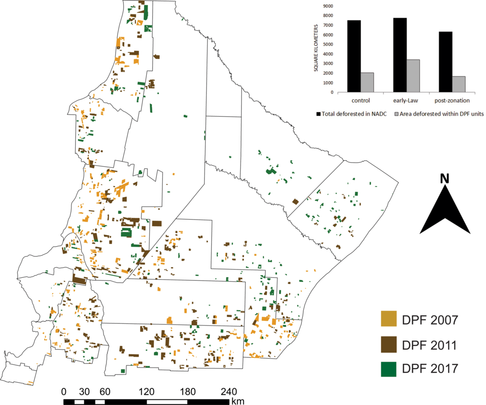
During the 2000–2017 period, 2 157 476 ha were deforested in the NADC region (12% of the total area) (Fig. 1), at a rate of 107 276 ha year–1 during 2000–2007, 193 685 ha year–1 during 2007–2011 and 105 300 ha year–1 during 2011–2017 (Table S2). A third of the area deforestation during 2000–2017 occurred within 1056 DPF units (i.e., 710 532 ha across 1056 properties that were fenced prior to being deforested). The distribution of the DPF units was uneven across the period included in our analyses, across the classes of the NFL and across the departments of the study area.
DPF units in Northern Argentinian Dry Chaco (NADC) region. Map of the NADC region showing area deforested and previously fenced (DPF units) during three periods between 2000 and 2017: DPF 2007 units belong to the ‘control period’, from 2000 to 2007; DPF 2011 units correspond to the ‘early-law period’, from 2007 to 2011; and finally, DPF 2017 units belong to the ‘post-zonation period’, from 2011 to 2017. Additionally, bar graphs show the total area deforested by period in the whole NADC and, specifically, within fences (i.e., DPF units).

To compare the area within DPF units among the three periods analysed, since the periods were of different durations, we expressed values as the percentage that the area within DPF units represented in relation to the total area deforested during the same period. The percentages of areas within DPF units were 27% during the ‘control period’ (i.e., 205 210 ha across 338 DPF units of the total 750 933 ha deforested during 2000–2007), 44% during the ‘early-law period’ (i.e., 340 161 ha across 425 DPF units of the total 744 740 ha deforested during 2007–2011) and 26% during the ‘post-zonation period’ (i.e., 165 161 ha across 293 DPF units of the total 750 933 ha deforested during 2011–2017) (Fig. 1; detailed results at the level of departments and provinces are provided in Table S2).
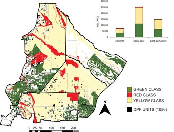
We then compared the percentages of the area in DPF units among the three classes of NFL land zonation during the period 2007–2017 (i.e., across a total of 505 322 ha within DPF units). Only 34% of the area in DPF units was in the green class, while 41% occurred in the yellow class and another 2% of the area in DPF units was observed in the red class of land zonation. The remaining 23% of deforestation belonged to the fourth class of ‘others’ (including particular adaptations of the activities allowed according to provincial criteria; see ‘Methods’ section).
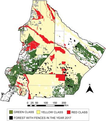
According to our results, 522 813 ha that had been deforested were located in DPF units between the creation of the NFL (year 2007) and the year 2017 (Fig. 2). A total of 177 178 ha were deforested in DPF units in green zones, and these were mostly distributed along Anta, Metán (both in Salta province) and Almirante Brown departments (in Chaco province) (44%, 14% and 10% of the total, respectively). Of the 216 276 ha deforested in DPF units within the yellow class during the same period, 64% was distributed in Alberdi, San Martín and Almirante Brown departments (26%, 21% and 15%, respectively). Of the 8358 ha deforested in DPF units within the red class between 2007 and 2017, 83% was concentrated within Anta and Rivadavia departments of Salta province (43% and 40%, respectively) (Figs 1, 2 & S1 & Table S2). A total of 121 001 ha deforested within DPF units were distributed in the ‘others’ class in the NADC. We also identified the area that was fenced but had not been deforested in 2017 (Fig. 3). A total of 327 386 ha were observed as fenced across the whole NADC by 2017, of which 182 888 ha (c. 56%) were located in the yellow class, whereas 3519 ha (c. 1%) were in the red class of land zonation (Fig. 3).
DPF units and forest-zonation maps. Map of the land zonation of forests with the three main classes (i.e., green, yellow and red classes) for the Northern Argentinian Dry Chaco region. Area deforested that was previously fenced (i.e., DPF units) is also shown. Additionally, bar graphs numerically represent the distribution of the area of DPF units across the classes of the land zonation, among the three periods of the Native Forest Law that were analysed.

Forest fenced and forest-zonation maps. Area of forest within fences by the year 2017, overlapped on maps of land zonation.

Discussion and conclusions
The digitization of Landsat imagery resulted in a novel, useful and simple technique that allowed us to identify the erection of fences with deslindes in the NADC. This work is the first to suggest the monitoring of new fences and deslindes as a proxy of private-control reinforcement, and of apparently imminent land-use changes, as well as for updating the provincial forest-zonation maps.
Up until 2017, 12% of the NADC region was deforested. Our results show that a third of the area deforested between 2000 and 2017 was previously fenced, thus confirming the first mechanism suggested: in a context of land-use changes for agricultural production, fences are often the first step prior to deforestation. This finding represents an opportunity for researchers and policymakers to design a dissuasive early-monitoring system for remote detection of deforestation, focusing on mapping the erection of new fences. In our work, we observed many areas that were deforested without the previous erection of fences. Consequently, not all deforestation occurring in the study area can be predicted by monitoring early signals from remote sensing, such as the erection of new fences. However, we argue that focusing on particularly sensitive areas (e.g., yellow zones) and monitoring early signals, coupled with contacting owners, can help dissuade actors whose intentions are to advance land-use restrictions. For example, by overlapping fences’ coordinates with the maps of the land zonation and the cadastral database, owners could be contacted and warned about penalties associated with breaking land-use restrictions. This system, however, could be improved by using shortened time periods (e.g., monthly) to identify risky areas of potential deforestation in close to real time.
The other two-thirds of the area that was deforested without previous erection of fences might reflect the fourth mechanism described: the purchase of land in a context of land-market speculation. This mechanism is mostly fuelled by international companies investing in quick land development, which would not require the settlement of fences, since the purchase of forested land, and its subsequent deforestation, occur in short periods, at least shorter than our temporal scale of analysis (Fairbairn Reference Fairbairn2014, le Polain de Waroux et al. Reference le Polain de Waroux, Garrett, Heilmayr and Lambin2016). Thus, using shorter time periods (e.g., annually or biannually) to identify properties that are rapidly fenced and deforested might better explore the questions we have posed.
Our results show that the erection of fences before deforesting mostly occurred between the NFL being passed and completion of the maps of land zonation (‘early-law’ period). This result is interesting for two reasons. Firstly, this period is the shortest under analysis, and thus values could be naturally lower. Secondly, there is evidence of a rush of deforestation in Salta province during the ‘control period’, as a consequence of uncertainties regarding land-use change allowances after 2007 because of both the shift of national and provincial governmental authorities and because of the imminent sanction of the NFL (Leake & Ecónomo Reference Leake and Ecónomo2008), in a context of social conflicts and contrasting perceptions about the deforestation (Zepharovich et al. Reference Zepharovich, Ceddia and Rist2020). Although that evidence is for Salta province, the shifts in governmental authority and context of the social conflicts were not exclusive for Salta province and operated at a national level. Our interpretation of this greatest relative area of DPF units during the ‘early-law’ period is that owners fenced and deforested their properties once the NFL was passed to secure their chance to put land to agricultural production (mostly soybean crops and cattle ranching), as they faced a possible imminent restriction that would ban them from changing land cover to productive cover once the land-zonation maps were completed.
The erection of fences in the forests of the Dry Chaco and the later deforestation occurred in all three of the classes of forest land zonation. In fact, while we expected that the highest percentages of area in DPF units would occur in the green class, since it is the class that is designated to allow drastic land-use changes, the percentage of area in DPF units (in relation to the total deforested area) was highest in yellow areas, where low-level deforestation is allowed but varies among provinces. This result demonstrates the low level of NFL compliance and is in accordance with the suggested need for strengthened law enforcement (Camba Sans et al. Reference Camba Sans, Aguiar, Vallejos and Paruelo2018, Volante & Seghezzo Reference Volante and Seghezzo2018).
The distribution of the DPF units was also heterogeneous across the study area, and in some departments the occurrence of DPFs was particularly high. When looking at departments by classes of land zonation, we observed that more than 80% of the area in DPF units was concentrated across Anta and Rivadavia; these departments of Salta province were thus complying the least with the NFL in the study area. Anta also attained the highest percentage of area in DPF units in the green class in comparison to the other departments, thus suggesting the existence of a common practice in Salta province of fencing prior to deforestation. In this province, on the other hand, the percentage of area in DPF units in the yellow zonation class was lower. Three departments belonging to three provinces together barely accounted for 50% of area in DPF units in the yellow class for the total study area.
If the deforestation rate of the period analysed continues (i.e., 105 300 ha year–1), as does the relationship between deforestation and the erection of fences that we observed (i.e., a third of the area deforested being previously fenced), we could expect that, by the year 2023, at least 109 000 ha will be deforested within previously fenced areas, and another c. 522 000 ha will be deforested in areas that were not fenced by 2017. Where exactly that deforestation is going to happen is uncertain, but if monitoring and penalties in the context of the NFL are not implemented, a large part will likely occur within the yellow class of land zonation.
We found that, by 2017, more than 300 000 ha of forest was fenced within the NADC, 56% of which was located in areas that fell under yellow zonation according to the NFL and 1% of which fell within areas classed as red zones. This stems from two possible mechanisms proposed in this work, both of which do not imply immediate deforestation. One of them is the erection of fences as a consequence of land transaction/acquisition (Altrichter & Basurto Reference Altrichter and Basurto2008), being bought by a producer or company who will either further production or as a speculative investment (i.e., land that is bought and then sold at a higher price) (Fairbairn Reference Fairbairn2014). The other possible mechanism is the erection of fences by landowners, who saw in the NFL an opportunity to subsidize their property’s infrastructure and simultaneously reinforce their private control.
Fencing in currently standing forests often represents a form of access restriction for local inhabitants (Ribot & Peluso Reference Ribot and Peluso2003, Altrichter & Basurto Reference Altrichter and Basurto2008). How fences affect the campesinos’ life, by restricting their access to natural resources, has been described for other regions worldwide (Dawson & Martin Reference Dawson and Martin2015), as well as for Córdoba province in the southern Dry Chaco ecoregion (Cáceres Reference Cáceres2015). Fences are presented as the materialization of a process of capital accumulation and a change of rules regarding the access to natural resources that are traditionally treated as common-pool resources. In addition, the NFL also promoted changes in forest resource uses, imposing in many cases restricted access for traditional producers to forage and collect forest products such as fuelwood (Cabrol & Cáceres Reference Cabrol and Cáceres2017).
In the sectors included in our study area, Altrichter and Basurto (Reference Altrichter and Basurto2008) point out that large landowners have fenced properties, thus reducing the area used by small producers of the puestos systems for livestock production and wildlife hunting. This is remarkable since puestos systems are widely distributed across the region, and half of the forested area is directly affected by their associated extensive livestock forage (Grau et al. Reference Grau, Gasparri and Aide2008). Moreover, Fernández et al. (Reference Fernández, Kuemmerle, Baumann, Grau, Nasca, Radrizzani and Gasparri2020) have characterized a sector included in our study area of traditional small producers whose cattle complete their cycle in the forest context. Lastly, there are sectors within our study area that are mostly inhabited by numerous indigenous communities (as in western Formosa province; Marinaro et al. Reference Marinaro, Grau, Gasparri, Kuemmerle and Baumann2017), whose properties are often adjacent to deforested or fenced properties. Based on those previous works and considering the regional context, we encourage the use of remote sensing to detect fences (with deslindes); this represents a significant advance and can be used as an indicator of restriction to accessing natural resources for traditional local populations at a regional level. However, future work could focus on the detection of specific conflicts at local and regional scales, such as by mapping and overlapping traditional and communal forest areas with the expansion of deforestation and the erection of fences.
Many of the local people living near to newly fenced properties are among the poorest people of Argentina (Longhi Reference Longhi2014) and are highly dependent on natural resources and ecosystem services for their survival and well-being. The state could play a key role in balancing agribusiness activities and land-privatization processes with the needs and livelihoods of local people (Krapovickas et al. Reference Krapovickas, Sacchi and Hafner2016), given that many of these fences are only for the investment of non-local peoples and have negative impacts on local people. Which ecosystem services and natural resources are the most enclosed by the erection of fences and how the restriction of access affects the daily well-being and subsistence of local people are crucial questions that still need to be more directly addressed. Future work including fieldwork and close contact with local people that is orientated towards describing social conflicts around access to natural resources and ecosystem services would be highly valuable.
Following more sustainable development trajectories requires governmental and societal intervention to simultaneously work at alleviating poverty and meeting the rising demand for agricultural commodities and natural resources, while protecting ecosystems and the services they offer (Gardner et al. Reference Gardner, Godar and Garrett2014). In this sense, even when land privatization is commonly promoted as a policy for wildlife conservation (Altrichter & Basurto Reference Altrichter and Basurto2008), and while fencing may be desirable for controlling livestock forage, it may result in the pervasive and undesirable exclusion of local people. In our opinion, the NFL represents an opportunity to better address trade-offs between forest conservation and sustainable management policies that indirectly promote the restriction of local people’s access to natural resources. Thus, focusing on human strategies in reaction to governmental policies is necessary to avoid incurring social–environmental injustices that are accidentally generated by genuinely well-intentioned conservation policies such as the NFL.
We highlight the need for exploring alternative ways to improve livestock management practices and to protect forests by developing conservation and management plans, while also guaranteeing access to natural resources for local people. This is particularly necessary in social–ecological systems including different property and land-use regimes, with mosaics of traditional land use and communal properties of indigenous people. We also encourage the tackling of new research questions in this direction, with an emphasis on deepening in particular the technical (e.g., by higher-resolution imagery) and social (e.g., by interviews on the ground) aspects of this process.
Supplementary material
To view supplementary material for this article, please visit https://doi.org/10.1017/S0376892920000314
Acknowledgements
We truly thank the comments and the language editing of Yann Le Polain, María Piquer-Rodríguez, Ricardo Grau and Olivia del Giorgio. We also thank the editors and two anonymous reviewers for their very insightful comments and suggestions.
Financial support
This work was supported by the Argentinian Ministerio de Ciencia, Tecnología e Innovación Productiva, the Agencia Nacional de Promoción Científica y Tecnológica, PICTO 2011 OTNA #98, and the CONICET.
Conflict of interest
None.
Ethical standards
None.